
Development of a UAV Based Framework for CH4 Monitoring in Sludge Treatment Centres
 ,
,
Abstract
: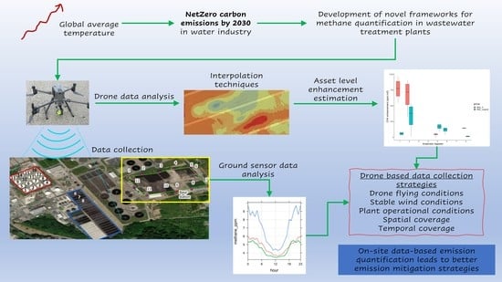
1. Introduction
2. Materials and Methods
2.1. Selection of the Case Study Area and WWTP Assets
2.2. Selection of UAV Platform and CH4 Sensor to Be Mounted Onboard
2.3. Data Collection
2.3.1. UAV Data Collection
2.3.2. Ancillary Data
2.4. Data Analysis
2.4.1. Characterization of Prevailing Winds
2.4.2. Influence of Emissions from Adjacent Sources
2.4.3. Identification of CH4 Sources
3. Results
3.1. UAV and Ancillary Data
3.2. Characterisation of Prevailing Winds
3.3. Influence of Emissions from Adjacent Sources
3.4. Identifying CH4 Sources
4. Discussion
5. Conclusions
Author Contributions
Funding
Data Availability Statement
Acknowledgments
Conflicts of Interest
Glossary
| BQL | Below quantification level |
| CAW | Carbon accounting workbook |
| CCC | Committee on Climate Change |
| CRDS | Cavity ring-down spectroscopy |
| EF | Emission factor |
| GHG | Greenhouse gas |
| GPS | Global positioning system |
| H | Height |
| L | Length |
| NDIR | Nondispersive infrared |
| RTK | Real-time kinematic |
| TDLAS | Tuneable diode laser absorption spectroscopy |
| UAV | Unmanned aerial vehicle |
| UNFCC | United Nations Framework Convention |
| VTOL | Vertical take-off and landing |
| W | Width |
| WWT | Wastewater treatment |
| WWTP | Wastewater treatment plant |
References
- Water UK. Ricardo, and Mott MacDonald, “Net Zero 2030 Routemap”. 2020, p. 90. Available online: https://www.water.org.uk/routemap2030/wp-content/uploads/2020/11/Water-UK-Net-Zero-2030-Routemap.pdf (accessed on 1 May 2023).
- Delbeke, J.; Runge-Metzger, A.; Slingenberg, Y.; Werksman, J. The paris agreement. In Towards a Climate-Neutral Europe Curbing the Trend; Routledge: London, UK, 2019; pp. 24–45. [Google Scholar] [CrossRef]
- National Statistics. Final UK Greenhouse Gas Emissions National Statistics: 1990 to 2020; Department Business, Energy & Industrial Strategy: London, UK, 2020; p. 47. Available online: https://www.ipcc-nggip.iges.or.jp/public/wetlands/index.html;%0Ahttps://www.gov.uk/government/uploads/system/uploads/attachment_data/file/295968/20140327_2013_UK_Greenhouse_Gas_Emissions_Provisional_Figures.pdf (accessed on 1 May 2023).
- UKWIR. Quantifying and Reducing Direct Greenhouse Gas Emissions from Waste and Water Treatment Process; UKWIR: London, UK, 2020. [Google Scholar]
- IPCC. Chapter 6: Wastewater Treatment and Discharge. In 2006 IPCC Guidelines for National Greenhouse Gas Inventories; IPCC: Geneva, Switzerland, 2006; Volume 5, pp. 1–56. [Google Scholar]
- Daelman, M.R.; van Voorthuizen, E.M.; van Dongen, U.G.; Volcke, E.I.; van Loosdrecht, M.C. Methane emission during municipal wastewater treatment. Water Res. 2012, 46, 3657–3670. [Google Scholar] [CrossRef]
- Nathan, B.J.; Golston, L.M.; O’brien, A.S.; Ross, K.; Harrison, W.A.; Tao, L.; Lary, D.J.; Johnson, D.R.; Covington, A.N.; Clark, N.N.; et al. Near-Field Characterization of Methane Emission Variability from a Compressor Station Using a Model Aircraft. Environ. Sci. Technol. 2015, 49, 7896–7903. [Google Scholar] [CrossRef] [PubMed]
- Allen, G.; Pitt, J.; Hollingsworth, P.; Mead, I.; Kabbabe, K.; Roberts, G.; Percival, C. Measuring Landfill Methane Emissions Using Unmanned Aerial Systems: Field Trial and Operational Guidance; Environment Agency: Bristol, UK, 2015.
- Yang, S.; Talbot, R.W.; Frish, M.B.; Golston, L.M.; Aubut, N.F.; Zondlo, M.A.; Gretencord, C.; McSpiritt, J. Natural Gas Fugitive Leak Detection Using an Unmanned Aerial Vehicle: Measurement System Description and Mass Balance Approach. Atmosphere 2018, 9, 383. [Google Scholar] [CrossRef] [Green Version]
- Delre, A.; Mønster, J.; Scheutz, C. Greenhouse gas emission quantification from wastewater treatment plants, using a tracer gas dispersion method. Sci. Total Environ. 2017, 605-606, 258–268. [Google Scholar] [CrossRef] [PubMed] [Green Version]
- Ren, H.; Zhao, Y.; Xiao, W.; Hu, Z. A review of UAV monitoring in mining areas: Current status and future perspectives. Int. J. Coal Sci. Technol. 2019, 6, 320–333. [Google Scholar] [CrossRef] [Green Version]
- Shah, A.; Pitt, J.; Kabbabe, K.; Allen, G. Suitability of a non-dispersive infrared methane sensor package for flux quantification using an unmanned aerial vehicle. Sensors 2019, 19, 4705. [Google Scholar] [CrossRef] [PubMed] [Green Version]
- Webster, R.; Oliver, M.A. Geostatistics for Environmental Scientists, 2nd ed.; John Wiley & Sons: New York, NY, USA, 2007. [Google Scholar]
- Neumann, P.P.; Kohlhoff, H.; Hüllmann, D.; Krentel, D.; Kluge, M.; Dzierliński, M.; Lilienthal, A.J.; Bartholmai, M. Aerial-based gas tomography–from single beams to complex gas distributions. Eur. J. Remote Sens. 2019, 52, 2–16. [Google Scholar] [CrossRef] [Green Version]
- AiLF. User Manual UAV Based Laser Methane Leakage Detector. AiLF (Shandong) Instruments Inc. 2019. Available online: https://www.manualslib.com/manual/1860232/Ailf-U10.html (accessed on 1 May 2023).
- Driessen, W.; Snelson, P.; Chadha, M. Advanced Reject Water Treatment. 2014, pp. 1–6. Available online: https://waterprojectsonline.com/wp-content/uploads/case_studies/2012/Minworth-STW-Anammox-Plant-2012.pdf (accessed on 1 July 2023).
- Esri. ‘Imagery’ [basemap]. Scale Not Given. ‘World Imagery’. 12 December 2009. Available online: https://www.arcgis.com/home/item.html?id=10df2279f9684e4a9f6a7f08febac2a9 (accessed on 1 May 2023).
- Shaw, J.T.; Shah, A.; Yong, H.; Allen, G. Methods for quantifying methane emissions using unmanned aerial vehicles: A review. Philos. Trans. R. Soc. A Math. Phys. Eng. Sci. 2021, 379, 20200450. [Google Scholar] [CrossRef]
- Wheeler, M.D.; Newman, S.M.; Orr-Ewing, A.J.; Ashfold, M.N.R. Cavity ring-down spectroscopy. J. Chem. Soc. Faraday Trans. 1998, 94, 337–351. [Google Scholar] [CrossRef]
- Martinez, B.; Miller, T.W.; Yalin, A.P. Cavity Ring-Down Methane Sensor for Small Unmanned Aerial Systems. Sensors 2020, 20, 454. [Google Scholar] [CrossRef] [PubMed] [Green Version]
- DJI. MATRICE 300 RTK-Specifications-DJI. Available online: https://www.dji.com/uk/matrice-300/specs (accessed on 1 November 2022).
- DJI. Matrice 600 Pro. Available online: https://www.dji.com/uk/matrice600-pro (accessed on 1 July 2023).
- Baker Hughes. Lumen Terrain User’s Manual. Baker Hughes. 2019. Available online: https://manuals.plus/m/3635b9330db4c3aaf53bb2bf1efab08ebd71213a7446afb21db2df1666d9bf59.pdf (accessed on 1 May 2023).
- Yi, W.Y.; Lo, K.M.; Mak, T.; Leung, K.S.; Leung, Y.; Meng, M.L. A survey of wireless sensor network based air pollution monitoring systems. Sensors 2015, 15, 31392–31427. [Google Scholar] [CrossRef] [PubMed] [Green Version]
- Information, T.; Sensors, M.G. Technical Information for TGS2611 an ISO9001 and 14001 Company Technical Information for Methane Gas Sensors Technical Information for TGS2611. pp. 1–13. Available online: https://asset.conrad.com/media10/add/160267/c1/-/en/000183302DS01/datenblatt-183302-figaro-gas-sensor-tgs-2611-passend-fuer-gase-methan-o-x-h-92-mm-x-78-mm.pdf (accessed on 1 May 2023).
- Carslaw, D. The Openair Manual—Open-Source Tools for Analysing Airpollution Data; Manual for Version 2.6-6; University of York: York, UK, 2019; Available online: https://davidcarslaw.com/files/openairmanual.pdf (accessed on 1 May 2023).
- Allen, G.; Gallagher, M.; Hollingsworth, P.; Illingworth, S.; Kabbabe, K.; Percival, C. Feasibility of Aerial Measurements of Methane Emissions from Landfills; Environment Agency: Bristol, UK, 2014.
- Ermolaev, E.; Sundberg, C.; Pell, M.; Smårs, S.; Jönsson, H. Effects of moisture on emissions of methane, nitrous oxide and carbon dioxide from food and garden waste composting. J. Clean. Prod. 2019, 240, 118165. [Google Scholar] [CrossRef]
- Fane, S.; Nocker, A.; Vale, P.; Casado, M.R.; Cartmell, E.; Harris, J.; Fernández, Y.B.; Tyrrel, S. Characterisation and control of the biosolids storage environment: Implications for E. coli dynamics. Sci. Total Environ. 2020, 752, 141705. [Google Scholar] [CrossRef] [PubMed]
- Aldhafeeri, T.; Tran, M.-K.; Vrolyk, R.; Pope, M.; Fowler, M. A Review of Methane Gas Detection Sensors: Recent Developments and Future Perspectives. Inventions 2020, 5, 28. [Google Scholar] [CrossRef]
- Wang, C.; Yin, L.; Zhang, L.; Xiang, D.; Gao, R. Metal Oxide Gas Sensors: Sensitivity and Influencing Factors. Sensors 2010, 10, 2088–2106. [Google Scholar] [CrossRef] [Green Version]
- Duan, Y.-F.; Reinsch, S.; Ambus, P.; Elsgaard, L.; Petersen, S.O. Activity of Type I Methanotrophs Dominates under High Methane Concentration: Methanotrophic Activity in Slurry Surface Crusts as Influenced by Methane, Oxygen, and Inorganic Nitrogen. J. Environ. Qual. 2017, 46, 767–775. [Google Scholar] [CrossRef] [Green Version]
- Maldaner, L.; Wagner-Riddle, C.; VanderZaag, A.C.; Gordon, R.; Duke, C. Methane emissions from storage of digestate at a dairy manure biogas facility. Agric. For. Meteorol. 2018, 258, 96–107. [Google Scholar] [CrossRef]
- DeBruyn, Z.J.; Wagner-Riddle, C.; VanderZaag, A. Assessment of Open-path Spectrometer Accuracy at Low Path-integrated Methane Concentrations. Atmosphere 2020, 11, 184. [Google Scholar] [CrossRef] [Green Version]


| Platform Specifications | |
|---|---|
| Maximum flight time | 55 min (no payload), 33 min (maximum payload) |
| Transmission range | 15 km |
| Transmission frequency | 2.4–5.8 GHz |
| Maximum descend speed | 7 m s−1 |
| Maximum speed | 23 m s−1 |
| Wind resistance | 15 m s−1 |
| Maximum payload capacity | 2.7 kg (mount up to 3 payloads) |
| Operating temperature | −20 °C to 50 °C |
| Volume | L 810 × W 670 × H 430 mm (unfolded, propellers excluded) |
| Weight | Approximately 3.6 kg (without batteries) |
| Sensor Specifications | |
| Detection laser | Class IIIR |
| Static detection limit | 5 ppm·m |
| Sampling frequency | 500 kHz |
| Response time | 0.025 s |
| Measuring range | 0–50,000 ppm·m |
| Maximum distance | 100 m |
| Working temperature | −20–50 °C |
| Operating humidity | <90% relative humidity |
| Volume | L 155 × W 90 × H 100 mm |
| Weight | 520 g |
| Survey Description | ||||||
|---|---|---|---|---|---|---|
| Asset | Date | N° Missions | Area (m2) | N° CH4 Points | Effective Surveying Time (h) | |
| AD | 21 March 2022 | 6 | 22,500 | 3771 | 4.5 | |
| 18 May 2022 | 8 | 22,500 | 284 | 5.5 | ||
| DST | 4 November 2022 | 1 | 1430 | 532 | 0.3 | |
| CP | 18 March 2022 | 3 | 1560 | - | 0.5 | |
| UAV ancillary data | ||||||
| Asset | (m s−1) | (°) | (°C) | (%) | (hPa) | |
| AD | 2.7 ± 0.1 | 151 ± 9 | 12.7 ± 0.7 | 59 ± 4 | 1025.8 ± 0.4 | |
| 4.7 ± 0.1 | 194 ± 5 | 18.0 ± 1.4 | 58 ± 3 | 1018.3 ± 1.2 | ||
| DST | 4.9 | 302 | 12.3 | 72 | 1013.8 | |
| CP | N/A | N/A | N/A | N/A | N/A | |
| Metal oxide ground sensor data | ||||||
| Asset | (m s−1) | (°) | (°C) | (%) | ||
| AD | 1.00 ± 0.01 | 117 ± 21 | 12.6 ± 1.2 | 64 ± 2 | ||
| 0.88 ± 0.01 | 164 ± 36 | 22.5 ± 1.4 | 62 ± 4 | |||
| DST | 0.130 ± 0.001 | 311 ± 15 | 11.8 ± 0.4 | 75 ± 1 | ||
| CP | 2.01 ± 0.04 | 126 ± 21 | 15.9 ± 0.5 | 64 ± 2 | ||
Disclaimer/Publisher’s Note: The statements, opinions and data contained in all publications are solely those of the individual author(s) and contributor(s) and not of MDPI and/or the editor(s). MDPI and/or the editor(s) disclaim responsibility for any injury to people or property resulting from any ideas, methods, instructions or products referred to in the content. |
© 2023 by the authors. Licensee MDPI, Basel, Switzerland. This article is an open access article distributed under the terms and conditions of the Creative Commons Attribution (CC BY) license (https://creativecommons.org/licenses/by/4.0/).
Share and Cite
Abeywickrama, H.G.K.; Bajón-Fernández, Y.; Srinamasivayam, B.; Turner, D.; Rivas Casado, M. Development of a UAV Based Framework for CH4 Monitoring in Sludge Treatment Centres. Remote Sens. 2023, 15, 3704. https://doi.org/10.3390/rs15153704
Abeywickrama HGK, Bajón-Fernández Y, Srinamasivayam B, Turner D, Rivas Casado M. Development of a UAV Based Framework for CH4 Monitoring in Sludge Treatment Centres. Remote Sensing. 2023; 15(15):3704. https://doi.org/10.3390/rs15153704
Chicago/Turabian StyleAbeywickrama, Hiniduma Gamage Kavindi, Yadira Bajón-Fernández, Bharanitharan Srinamasivayam, Duncan Turner, and Mónica Rivas Casado. 2023. "Development of a UAV Based Framework for CH4 Monitoring in Sludge Treatment Centres" Remote Sensing 15, no. 15: 3704. https://doi.org/10.3390/rs15153704