A Generic Classification Scheme for Urban Structure Types


Department of Geoinformatics—Z_GIS, University of Salzburg, 5020 Salzburg, Austria
*
Author to whom correspondence should be addressed.
Remote Sens. 2019, 11(2), 173; https://doi.org/10.3390/rs11020173
Submission received: 2 December 2018
/
Revised: 3 January 2019
/
Accepted: 15 January 2019
/
Published: 17 January 2019
(This article belongs to the Special Issue Remote Sensing for Urban Morphology)
Abstract
:This paper presents a proposal for a generic urban structure type (UST) scheme. Initially developed in the context of urban ecology, the UST approach is increasingly popular in the remote sensing community. However, there is no consistent and standardized UST framework. Until now, the terms land use and certain USTs are often used and described synonymously, or components of structure and use are intermingled. We suggest a generic nomenclature and a respective UST scheme that can be applied worldwide by stakeholders of different disciplines. Based on the insights of a rigorous literature analysis, we formulate a generic structural- and object-based typology, allowing for the generation of hierarchically and terminologically consistent USTs. The developed terminology exclusively focuses on morphology, urban structures and the general exterior appearance of buildings. It builds on the delimitation of spatial objects at several scales and leaves out all social aspects and land use aspects of an urban area. These underlying objects or urban artefacts and their structure- and object-related features, such as texture, patterns, shape, etc. are the core of the hierarchically structured UST scheme. Finally, the authors present a generic framework for the implementation of a remote sensing-based UST classification along with the requirements regarding sensors, data and data types.
1. Introduction
In day-to-day language, we frequently use terms like building blocks or residential areas. These terms refer to certain architectural concepts, sociological discriminable units and the organization of urban structures in space. Planners try to distinguish between land use and urban structure. Urban structure is a more generic concept describing the arrangement of actual land use and potential land use in urban areas. Seen this way, structure may be synonymous with urban spatial structure, which concerns the arrangement of public and private space in cities and the degree of density and connectivity of the constituent elements. The concept of urban structure types (USTs) was initially developed in the 1960s when they were used for urban planning in German cities [1], and then introduced in the context of urban ecology by Duhme and Pauleit [2] in 1992.
In terms of the functions of space and the city as a place of interactions, Batty [3] presents and explicates models that simulate urban dynamics in the context of complexity theories. These models relate different scales of urban structure with each other and build on the theories of complexity as they try to link urban structural processes with local or regional (inter-)actions. The concept of urban morphology is sometimes used synonymously with urban structure but is also seen differently. According to Moudon [4], urban morphology is the study of the city as a human habitat, which means that urban morphologists focus on the tangible results of social and economic forces. Levy [5] introduces the aspect of time as he highlights the differences between the typology and the morphology itself and argues for the importance of morphologic transformations for the analysis of today’s urban fabric. Considering the mentioned arguments, Gauthier & Gilliland [6] give a general definition of urban morphology as the study of city forms. Despite the fact that the other authors mention the existence of different schools of thought relating to urban morphology [4,6], the processes of city transformations, the functions of space, and the connection to certain socioeconomic aspects are intrinsic constituent parts of this field of research. In contrast, this paper focuses on the physical urban structure itself.
In the context of studies of the physical structure of urban areas and, particularly, along with the increasing number of remote sensing applications for urban areas, the urban structure type (UST) approach is somewhat established within the remote sensing community using different kinds of sensors [7,8,9,10]. However, the concept still suffers from a very inconsistent use of the term and, subsequently, from highly diverse understandings of the subject and implementations. USTs are defined by specific spatial characteristics, e.g., the morphology and the spatial relationships between urban artefacts such as buildings, streets, trees, lawns [11]. However, USTs are also often defined by a specific land use. How land use influences the process of assigning particular USTs appears to be important from the researcher’s point of view. This research investigates the correlating characteristics of urban morphology and urban land use. There is no doubt that the urban structure is influenced or may even be determined by its actual use. However, in order to be “used”, the urban structure itself has to exist; otherwise, it is impossible to address a certain land use to an urban structure.
This study analyses current classification schemes of USTs, the use of USTs within literature, and highlights existing inconsistencies and knowledge gaps. Existing studies proposing schemes for USTs are reviewed with regard to their usability and applicability. Emphasis is placed on the difference between urban structure itself and the urban land use, and it is suggested to address the land use for particular USTs at a semantic level. This semantic level refers to the (multifunctional) land use practice of those structural elements that form structure types.
We propose a new concept of a structure- and object-based typology: generic Urban Structure Types (USTs). Intrinsic goals of this generic approach are the transferability and the replicability. Secondly, we analyze the proposed hierarchical UST scheme regarding its remote sensing applicability. In analogy to Hecht et al. [12], we identify and classify possible data sources, i.e., remote sensing systems for the acquisition of USTs, as well as defining the nature and specificities of the remote sensing data itself.
2. Materials and Methods
2.1. Theoretical Background
Urban morphology studies the form of human settlements and the processes of their formation and transformation. It has its roots in geography and urban sociology, where scholars seek to understand the spatial structure and character of an urban area by examining the patterns of its component parts and the ownership and utilization of dwellings. Nevertheless, urban studies are based on different schools of thought with different aims and social theories [4,13,14,15]. Only more recent studies focusing on the objectification of urban form [16,17] try to develop neutral, purely descriptive views of urban areas.
In this article, we hypothesize that only such a pure, descriptive, almost theory-free notion needs to be enforced for a highly transferable methodology and its implementation. Such a notion may be criticized as a reductionist view and that cultural aspects, land use, and cultural and architectural traditions, etc. are neglected. However, the inclusion of the latter would hamper a comparison between cities in different climatic zones and cultural hemispheres.
The term ‘structure’ becomes a central concept when considering urban morphology as the study of urban tissue or fabric. The implementation in terms of mapping and quantification also necessitates a distinction between coherent neighborhood morphology (open spaces, buildings, roads) and functions (human activities) because functions are mostly associated with land use, which has already been excluded for a purely descriptive approach. Instead, the core idea is that urban structure exhibits recognizable patterns in the ordering of buildings, spaces and functions, in which variation reinforces an organizing set of principles. This pure descriptive view would not be possible without the progress in spatial analysis over the last three decades or so. Many disciplines use elements of urban morphology that are predominantly based on theoretical frameworks. Although this is not a problem, as such, it hinders the comparison of the urban fabric between, for instance, Helsinki and Rio de Janeiro. We argue for a purely structure-based approach where urban activities and their interactions—mainly land use and transport—will only be integrated in later steps using a variety of theoretical—mainly economic and sociologic-frameworks built around socio-economic relationships between activities [14,18,19].
2.2. An Analytical Review of Existing UST Approaches
A number of approaches have delineated the urban system into distinct configurations of built-up areas, impervious open spaces, urban green spaces and infrastructure [7]. Others have proposed a hierarchical layer order by using configurations of residential buildings, green- and other open spaces, traffic areas and industrial-/commercial areas [21]. A listing—without claiming to be exhaustive—of proposed USTs and the respective references can be found in Table 1. In Table 2, important literature has been identified that refers to the UST concept but does not provide or present particular USTs. Independently from their actual nomenclature, scale or complexity, USTs are seen as an essential support for planning authorities, spatial planners in general or as keystone in planning processes [1,7,21,22,23]. According to Banzhaf & Hofer [24], USTs support effective urban management. They could serve as a foundation for monitoring, controlling and modelling tasks of urban planners and decision makers during ongoing urbanization processes [23]. For this study, it has been essential to identify a common nomenclature, a common language between urban remote sensing and urban planning that facilitates realizing such synergistic benefits (see Section 2.3. Specificity of cities vs. generic applicability). It is a prerequisite that USTs have a multi-layered character, as will be explained further on: this scheme will avoid including objects of completely different sizes within the same level, e.g., city center and single-family house. In addition, a clear distinction between the different (semantic) layers and the object dimensions is essential (see Section 2.3 Specificity of cities vs. generic applicability). The local climate zones (LCZs) are a representative example of how different urban structures can be separated with regard to a certain typology (see Section 2.4 Related and alternative concepts). In an attempt to systematically review previous research, Table 1 summarizes a broad variety of USTs. The basis of these USTs is often a land cover map, a land use map, or a definite to indefinite combination of these two. These classifications are generated both supervised and unsupervised; even explicitly manual classifications are used to produce basic data.
2.3. Specificity of Cities vs. Generic Applicability
Among the many examples of USTs that exist in the literature, there are only a few that use the same USTs for more than one city in terms of definition, description and derivation. From the 30 articles studied, only five studies apply their presented USTs to more than one city: four studies address two cities [21,26,27,42], while Bochow et al. [11] address three cities but include country-specific aspects for the definition of the respective USTs. The derivation of local-specific structure types such as “social housing”, “informal settlement” etc. are essential for local and regional spatial analyses. As stated by Bochow et al. [11], there is a need for a flexible and adaptable approach for automatable USTs since the selection of USTs usually takes place with respect to a particular research question, a particular application and a particular type of urban agglomeration. However, this adaptation to regional and local characteristics impedes transferability to other areas or even standardization of such urban structural types [16,44]. Paradoxically, the scheme is designed to be conceptually universally applicable, but its realization leaves room for individual adaptations.
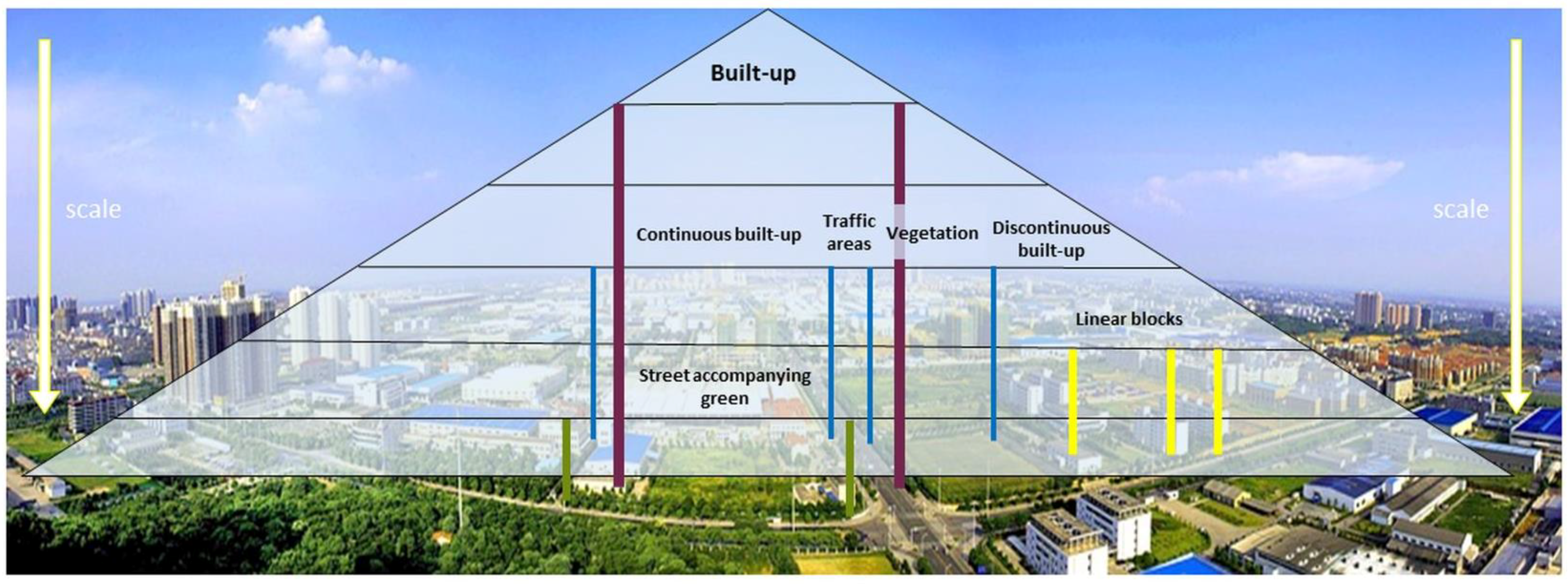
As mentioned beforehand, common UST classifications often are generated supervised, unsupervised or USTs are even partly derived manually. The extent to which each classification type is applied depends on the individual case and therefore varies between cities; sometimes even this extent remains unclear to the reader as it is not evident which urban artefacts or structures have been manually or automatically delineated. Thus, the process of establishing such a basis is not subject to standardization. In addition, the proposed USTs often have a two-dimensional character. This means that the USTs describe only one level of urban structure on the basis of a given scale. The USTs thus only cover one level of the city structure, with the recognizable tendency to cover a scale as small as possible with the help of very high-resolution remote sensing data (such as satellite data). As stated by Taubenböck et al. [22], “urban structure” must be defined as a multi-layered term including the temporal dimension of urban transformation, the physical sphere of its objects and the condition of demographic, socio-economic and political influences. Consequently, urban structure can be found at all scale levels [24,29]. It typically starts with the distinction between built-up and non-built-up, i.e., the distinction between built-up and vegetation, and develops towards the distinction between built-up, vegetation, water and bare soil. For higher-resolution data, a distinction can be made between continuous and discontinuous built-up, vegetation, water and bare soil, which demonstrates that USTs are present at all scale levels (Figure 1). The types of urban structures one chooses to depict depends on the desired scale level: mixing scale levels also makes it difficult to assign a certain urban structure type.
The presence of, e.g., the structure type “continuous built-up” next to the “single family house” type may be confusing, as both types are located at different scale levels.
For many researchers, their urban structure classification scheme should depict not only one (e.g., the morphology) but many aspects of the urban landscape.; whether these aspects merge into characteristic values of population densities [27,45], land use structures [26,46,47], or the legal aspects of how land is used [37,48]. One important aspect of urban areas is the land use. Nevertheless, land use and urban structure may or may not necessarily be congruent. Even though USTs and land use types are sometimes used interchangeably or intermingled in the literature [26,42], one may assume that a well-trained city planner can differentiate between the mere use of space for a specific purpose and the spatial-structural characteristics of buildings. With the given example, we emphasize that the term “urban structure type” refers to the constructional characteristics of a surface, i.e., its structure and not the (usable) surface for a specific purpose.
2.4. Related and Alternative Concepts
As discussed in Section 2.1 Theoretical Background and 2.3 Specificity of cities vs. generic applicability, the urban structure type approach has been established, enabling holistic descriptions of a city and its interactions [20]. In contrast to USTs, local climate zones (LCZs) are a generic, climate-based typology of urban and natural landscapes [43]. LCZs are defined as “regions of uniform surface cover, structure, material, and human activity that span hundreds of meters to several kilometres in horizontal scale” [43,49] and have a “characteristic screen-height temperature regime”. The introduction of the LCZs within the frame of the WUDAPT project highlights the definition of a common standard that is applicable for all urban agglomerations on a global scale. The abbreviation WUDAPT stands for ‘The World Urban Database and Access Portal Tools’. It is a community-based project to gather remote sensing-based information for urban climate studies. The concept of WUDAPT allows researchers around the world to study a specific city even if certain local climate zones do not occur within the area; neither the workflow nor the analysis are influenced by the absence of particular local climate zones, such as “water”, “compact high-rise”, “dense trees” or others. The LCZ approach demonstrates that the urban structure type approach has the potential to describe the composition of a city, following an urban planning-based typology.
A well-known information system of land use and land cover is the CORINE Programme with its specific CORINE Land Cover (CLC) nomenclatures and methodologies. In contrast to the LCZs typology, the minimum mapping unit of CORINE does not depend on the spatial resolution of the used satellite sensor imagery; a specific threshold is used for the classification. This means that objects of less than 25 ha area cannot be present in the database [50]. For the CORINE Land Cover Change (CLCC) mapping, the minimum mapping unit is set to 5 ha in order to collect information relevant to European policy [50]. The hierarchical nomenclature of the CLC includes land cover as well as land use and is not limited to urban areas. The objective of the program is to cover and classify the entire European area plus the areas of countries that are program partners. Every land cover type is classified according to the CLC nomenclature. The input data used for the classification varies from one country to another because national teams produce the database for their own country and that data is later integrated at the European level. Most countries still produce the data by visual interpretation of high-resolution satellite images. There is no special focus on urban areas in the CORINE Programme and the fact that the representation of (small) urban artefacts is neither prioritized nor can be achieved due to the limited resolution, impedes the use of CLC for detailed urban structural analysis.
Another remote sensing related framework for a national land use and land cover classification was proposed by Anderson et al. [46]. Although the remote sensing data, sensors, and instruments have evolved since 1976, many basic statements are still valid today, including the description of the terms “land cover” and “land use” as well as the fact that in almost any classification process, it is rare to find the clearly defined classes that one would like [46]. However, the proposed (hierarchical!) classification scheme is very remote sensing oriented and specifically emphasizes the land use. This means that certain (land cover) classes are designed in such a way that certain land use types (e.g., mining operations in the class “Industrial”) are demonstratively included. Object-related information such as the (building) density of residential (land use) areas should be included in a possible evaluation of the class “Residential”. With their innovative approach, Anderson et al. [46], highlight the still challenging task of combining remote sensing data and ancillary data for a classification of both land cover and land use by means of one classification scheme only.
2.5. Conclusions of the Status Quo
The inconclusive character of the current UST approach means that there is neither a consistent and standardized framework nor a coordinated strategy for nation-wide mapping of UST [44] which limits its actual application. One aspect of the flexibility is the use of different nomenclature that does not necessarily match with the vocabulary of the addressed target group; the urban planners. A general acceptance of any UST scheme cannot automatically be assumed. However, it is more likely that stakeholders of different disciplines use a particular typology if there is a common base, e.g., in the form of a common terminology. Consistency is crucial for this common terminology to be possible, and it must span different layers and different dimensions of scale. The consistent terminology necessitates the separation between social aspects (e.g., poor, social housing, gated communities, and suburbia), specific values (e.g., floor-space index, energy efficiency, net energy use) and USTs. Together with their expertise and with their insights from the local knowledge of communities, (local) urban planners are equipped to use (remotely sensed) USTs as a (data) base that allows for calculation of specific values such as floor-space index or net energy use. In the context of the increased discussion about participative (urban) planning and public participation in general, it is clear that planners will increasingly play a mediating role between policymakers and various public stakeholders. In this scenario, new approaches of incorporating local community knowledge need to be adopted [51]. However, USTs themselves are not specific values or “mathematical” components of a certain social aspect that urban planners may consider. The UST approach will not provide an all-encompassing explanation for urban-economical or urban spatiotemporal phenomena. The UST typology and various implementations, such as USTs based on remote sensing data, shall serve as a method and a tool for urban planners.
3. A proposal for a Generic UST Scheme
Based on the insights from the literature review and from the analyzed requirements for hierarchically and terminologically consistent USTs, we argue for the necessity of a structural- and object-based typology.
3.1. Goal
The presented typology and the USTs shall be suitable for all urban areas of all continents. Therefore, a UST scheme shall be presented which is as generic as possible. Any reference to land use as part of the typology is omitted. There are approaches in the literature that use remote sensing imagery or portals like Google Street View or Volunteered Geographic Information. Some of these approaches make statements about the use of objects. Nevertheless, it seems that efforts striving for generically applicable schemes are comparatively small in numbers. No standardized, transmittable and consistent application has been developed yet. Therefore, a land-use typology that could fulfil the requirements of a hierarchical and terminologically consistent urban structure typology is not available.
3.2. Spatial Requirements
Similar to other descriptive classification schemes [46,47,52], we propose a scheme following hierarchical levels. These hierarchical levels are aligned with the spatial scale; i.e., on a large scale (e.g., 1:1,000,000) the distinction of merely a very limited number of USTs is possible. A precondition for the application of a certain (descriptive) level is the clear and comprehensive delimitation of objects. This operation is the translation of structure-and object-related features such as texture, patterns, shape etc. into the-typically generalizing-urban structure type scheme. We need to clearly state that the generic UST scheme is not remote sensing orientated; i.e., the scale of type allocation does neither refer to the geometric resolution of satellite images (pixel sizes) nor to other remote sensing data specifications.
3.3. Proposed UST Scheme
The proposed USTs are presented in Figure 2. This generic proposal targets cities worldwide, in all climatic regions. Within these cities, the proposed USTs shall cover all types of urban artefacts that are identified at a certain level of scale.
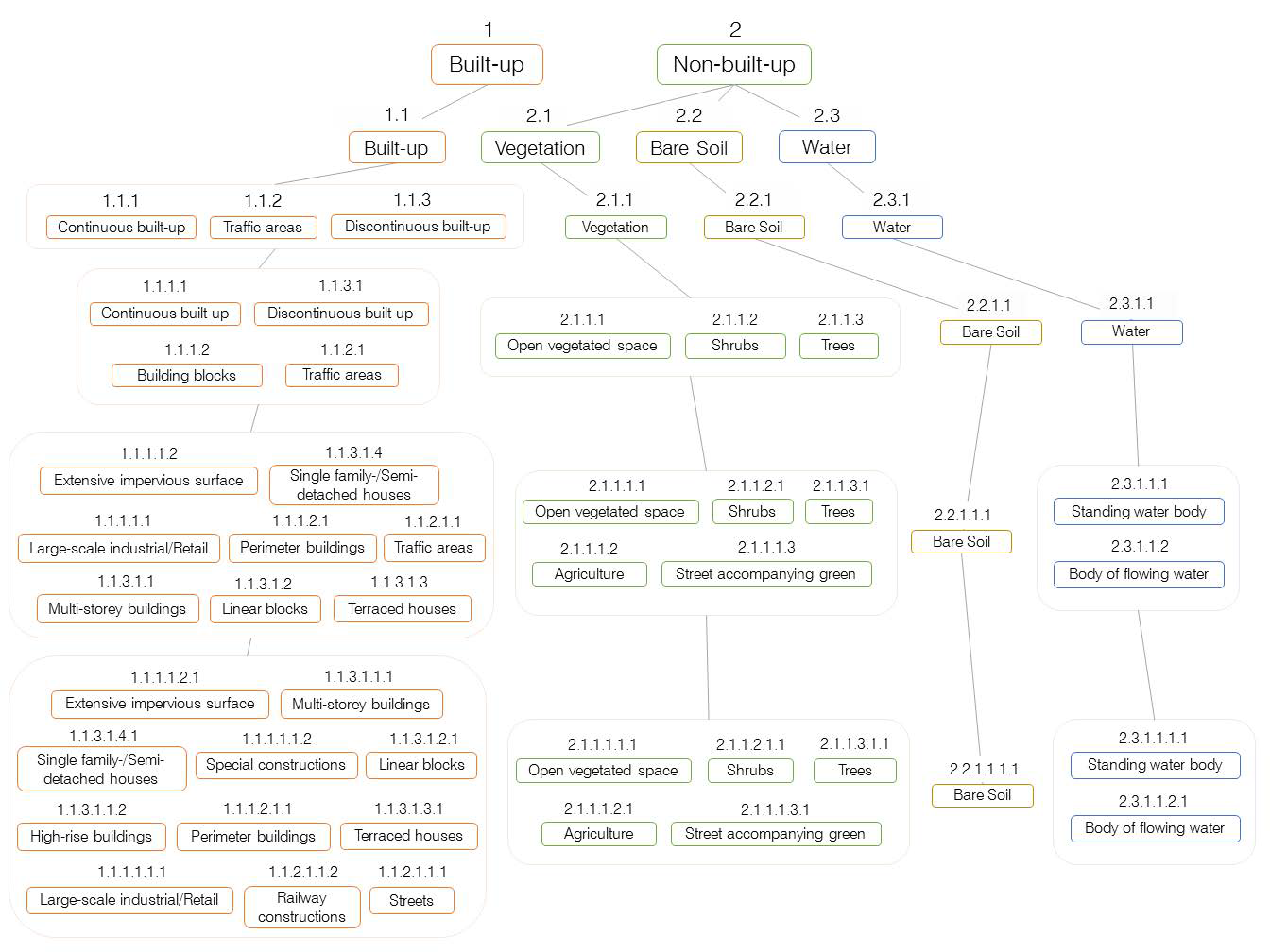
At the top level (Figure 2), a fundamental differentiation between built-up and non-built-up is made. Built-up consist of artificial surfaces such as buildings, man-made impervious surfaces and related constructions of all kind. Non-built-up includes all other areas including pervious surfaces, bare soil, vegetation and water. Thus, the second level comprises the USTs Built-up, Vegetation, Bare Soil and Water.
At the third level, only built-up areas are further differentiated into more or less isolated objects, Continuous built-up areas, and Traffic areas that constitute linear and elongated objects of, e.g., impervious surface.
At the fourth level, we differentiate built-up USTs further into continuous built-up, discontinuous built-up, building blocks, and traffic areas respectively. The UST building blocks are composed of the UST continuous built-up that is surrounded by the UST traffic areas.
A significant number of authors differentiate vegetated areas into recreational areas, urban parks, public urban green space or even differentiate between different types of recreational areas. The fact that the terms ‘recreational areas’ or ‘park’ mostly refer to a certain legal state (public) and that they have certain characteristics in accessibility or ownership restricts their suitability for urban structure typology. As mentioned before, information about the legal status of an area or its recent land use shall not be part of the proposed typology. Therefore, plausibility, transferability, and usability—in this case—can only be guaranteed at the expense of a limited level of detail within certain groups of USTs. Moreover, it is at least questionable how relevant the labour-intensive identification of, e.g., outdoor tennis courts or outdoor baseball parks is for (large-scale) urban planning purposes. At the fourth level, vegetation is differentiated into the USTs open vegetated space, shrubs, and trees. These structure types differ significantly in form, shape, and context in space. The UST open vegetated space still contains shrubs and/or trees up to a certain threshold. As mentioned before, we emphasize the clarity regarding the denomination of USTs; i.e., the denomination of a group of trees as “forest” is ambiguous. For the nonbiased reader, it is not clear whether “forest” refers to the ecological term of “forest”, the legal definition “forest” or the layperson term “forest”. An area legally defined as “forest” does not necessarily have to feature one single tree [53,54] or an area full of trees and bushes may not fulfil many ecological functions nor have a forest-specific climate.
At the fifth hierarchical level, for the UST group built-up, we differentiate between the USTs extensive impervious surface, single family-/semi-detached houses, large scale industrial/retail, perimeter buildings, traffic areas, multi-storey buildings, linear blocks, terraced houses. The USTs single family-/semi-detached houses and large-scale industrial/retail refer to the shape, the size, the form, and the spatial context of such areas rather than to a potential land use that they are usually connected with. Single family-/semi-detached houses are stand-alone houses that cover a smaller area. they are adjacent to traffic areas in a certain compass. Terraced houses (in literature often mentioned as “row houses”) appear as one linear and autonomous object. In contrast to single family-/semi-detached, this UST comprises several dwellings houses and terraced houses continuously cover a larger area. In contrast to linear blocks, terraced houses cover a smaller area, and the formed row of houses is aligned parallel to a street [55] or an extensive impervious surface within a certain proximity. The UST large-scale industrial/retail covers larger areas and usually also comprises larger areas of extensive impervious surface; it typically contains large-scale buildings. Due to the specific spatial context with other USTs and the specific form ratio (width to height) this UST can be differentiated from multi-storey buildings or perimeter blocks. Perimeter blocks are defined as building blocks that are surrounded by Traffic areas; they occupy a city block. The building(s) of a perimeter block separate the street from a possible courtyard; they usually have two orientations: street and courtyard [56]. Multi-storey buildings appear as autonomous objects, have multiple floors, cover a larger area and comprise different shapes. In contrast to multi-storey buildings, linear blocks comprise a linear shape and are generally orientated in one direction (e.g., N-S). A linear block stands free from adjacent buildings [56].
The UST vegetation is further differentiated into open vegetated space, shrubs, trees, agriculture, and street accompanying green. The UST agriculture consists of vegetated and non-vegetated areas adjacent to traffic areas or other USTs of the built-up group. Areas that form the UST agriculture usually do not contain shrubs or trees and are rectangular. Centre-pivot irrigated agricultural areas that might occur within urban areas, are in a specific spatial context (e.g., next to rectangular agricultural fields, defined by the distance to building/block related USTs). Street accompanying green is adjacent to traffic areas and has a specific elongated shape. The greening of rotary traffic (Brit.: roundabout) is enclosed by traffic areas in a certain distance and usually covers a smaller area than a centre-pivot irrigated agricultural field.
At the sixth hierarchical level (Figure 3), the UST group built-up is extended for the UST’s: special constructions, high-rise buildings, streets, and railway constructions. Special constructions consist of objects that do not belong to any other UST, due to the form and shape of the buildings, their relation to other USTs or the spatial context in general. Possible objects of this UST are antennas, antenna towers, large decorative elements, stadiums, water towers, storage tanks, power cable towers etc. High-rise buildings have a vertical form, are high, and stand free from adjacent buildings [56]; a high-rise building appears as an universal object [56]. It is defined differently according to its height in various jurisdictions which makes it impossible to provide a clear threshold. Still, for the UST high-rise buildings, the relationship between area and height is usually specific and allows the distinction to the USTs multi-storey buildings, large-scale industrial/retail and perimeter buildings. The USTs railway constructions and streets originate from the UST Traffic areas of the lower hierarchical level. The UST railway constructions have a specific elongated form, a specific shape, and the relationships to adjacent USTs usually differ from those of Streets.
The urban structure type ‘bare soil’ is not divided further and remains one type through five hierarchical levels. Neither the size, the slope, the occurring mobile objects nor the relation to adjacent USTs may serve as an exclusive characteristic of areas such as construction sites, sports areas (e.g., BMX tracks), quarries, archaeological sites, or simply uncultivated land in semi-arid climate zones. Expert knowledge, ancillary data from land use plans or information from other planning instruments are necessary to assign an area previously identified as the urban structure type ‘bare soil’ in a more precise way. In Figure 3, the USTs of the 6th hierarchical level are graphically depicted.
Table 1 reveals that the urban structure type ‘water’ is hardly recognized in literature as being a part of the urban structure. Nevertheless, depending on the location of the city and the predominant climate, water may play a decisive role within a particular urban planning project. Thus, it appears to be obligatory to recognize such area(s) as distinct urban structure types. The type ‘water’ can be further differentiated into the subsequent types ‘standing water body’ and ‘body of flowing water’ through its size, form, and the mobile objects that may be found within such an area. One may argue that (swimming) pools [57,58,59] or lakes are not considered as a proper urban structure type. Pools may vary in depth, water-level, function (recreational or aesthetic purposes) and accessibility. These characteristics and qualities are key for urban planning and for the accurate identification of land use. However, these qualities cannot be deduced from structure- or object-based properties alone and pools are therefore not assigned their own type in our UST scheme.
3.4. Remote Sensing Implementation
The acquisition of hierarchically consistent USTs by means of remote sensing requires a description of the required minimum resolution. This means that the specification of the hierarchical level should contain the specification of the minimum requirement in sensor type or information regarding the required spatial resolution. Hecht et al. [12] provide information on the possible sources for the acquisition of USTs. They highlight the remote sensing implementation and provide a workflow for the derivation of USTs. However, the presented USTs include information on the respective land use and only cover built-up land (buildings); structures, such as vegetation or water, are not represented. Kadhim et al. [60] provide a detailed overview of remote sensing systems and their spatial resolution in the context of sustainable urban development. In contrast to Kadhim et al. [60], we focus on the spatial resolution of (current) remote sensing systems in general (see Figure 4). The spatial resolution is crucial for the description of urban structure(s) and urban artefacts. The multitude of remote sensing systems and sensors available on the market allows for covering almost all spatial accuracy requirements with a variety of systems being explicitly advertised with emphasis on their high spatial resolution. Successful applications of hyperspectral data for the identification of USTs (e.g., [7] and Table 1) have been conducted. However, due to their spatial resolution (i.e., [7]), the additional use of ancillary data (LiDAR, orthophoto, vector data) is required. Furthermore, the materials used in the construction of objects can provide an important indication as to the use of these objects but does not necessarily provide information about the current use. Aside from the land use information itself, examples by Hofmann [37] and Niebergall et al. [61] show how the spectral, as well as the spatial information of urban structure (and/or image objects), allows even the legal aspect of land use to be assessed. Nevertheless, due to temporal and regional differences, the legal aspect of constructions is not included in the presented urban structure scheme.
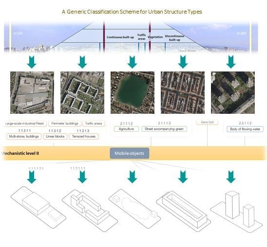
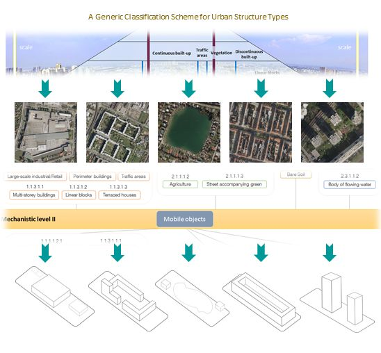
In Figure 4, the remote sensing implementation scheme for the classification of USTs is presented. The connections to USTs that form the superstructure are highlighted. Further, the connections and relationships to all subsequent groups of USTs are presented.
On a meta-level, the mechanistic level I and II (highlighted in a yellow colour bar) reside between the USTs. The mechanistic level represents an auxiliary means to improve the classification and delimitation of USTs; this level hosts so-called mobile objects. Mobile objects, e.g., depicted in optical remotely sensed imagery, may include motor vehicles, bicycles, people, tramways, sunshades of all kind etc. They should be included in the identification process of USTs of a certain hierarchical level whenever possible but cannot form an urban structure type of their own. While the terminology ‘temporary objects’ would highlight the temporal aspect of these objects’ existence within the image scene rather than the temporal aspect of their location, the authors decided to assign this class of urban artefacts the attribute ‘mobile’ in order to emphasize this characteristic.
Mobile objects potentially occur within all USTs and are hence useful for the exact identification of USTs and for the delimitation between categories. The characteristics of mobile objects such as their size, shape and number of occurrence reduce the number of eligible USTs and hence facilitate the identification process.
When working on remote sensing imagery, we propose a multiresolution image segmentation [62,63,64] for the delineation of potential USTs, following a hierarchical approach. Alternatively, existing GIS data or a combination of remote sensing data and GIS data may be utilized. Through the use of a class hierarchy and its inheritance (parent–child class relationships) [65], the UST scheme can be represented within an object-based image analysis (OBIA) [66] framework. The requirements for a structural- and object-based urban structure typology can generally be met by means of OBIA. As Blaschke et al. [67] (p. 186) point out, “image segmentation is not an end in itself. Segmentation is the partitioning of an array of measurements on the basis of homogeneity. It divides an image—or any raster or point data—into spatially continuous, disjointed and homogeneous regions. Depending on the segmentation process and segmentation parameters, resultant image objects vary in colour, shape, size and other intrinsic properties. The introduction of such objects allows for the analysis of the relationships between them: horizontally within one image layer and vertically through different super-imposed layers [68]. Created objects have (topological and non-topological) neighborhood relationships and hierarchical relationships, such as “is-part-of” or “consists of” [67]. Dependent on the user-requirements, particular levels of the USTs can hence be represented.
Examples for remote sensing sensors for each hierarchical level are presented in Table 3. The column next to the Latin numbers that indicate the hierarchical level shows the estimates of the minimum spatial resolution that is necessary to identify certain USTs of that specific hierarchical level. The values for the minimum spatial resolution of each level are mostly based on the maximum spatial resolution of current remote sensing systems (mostly satellites). The necessary resolution of the image data is indicated for each hierarchical level as well as other necessary remote sensing data.
3.5. Urban Planning Consultancy—Expert Interviews
The authors of this study aim for a high practicality of the proposed generic UST scheme for urban planning purposes. This should be achieved through the involvement of urban planning experts and their professional judgment. The proposed scheme underwent a critical evaluation by two experts. These experts were the head of an urban planning department of a city with a population of about 300,000 inhabitants and a person in charge of an urban planning and city development department in a city of about 2 million inhabitants. After a general introduction of the topic according to Section 2.1, the generic classification scheme (Figure 3) was presented to these urban planning experts in printed form. For each UST and for each hierarchical level, they were asked to evaluate the consistency and plausibility. They were asked if the used terminology coincides with their professional vocabulary. They could verify that most USTs are in accordance with the terminology used in urban planning. They mentioned that the USTs ‘Continuous built-up’ and ‘Discontinuous built-up’ are plausible but are not used within their respective departments. The UST ‘Street accompanying green’ attracted both experts’ attention since they explicated that this type reflects an important aspect of quality of urban green space; yet, there is no corresponding category within their department that covers such quality aspects. In general, they stated that this UST scheme shows a higher level of detail as compared to their current morphological or structural typologies used; examples that have a higher level of detail are as follows: ‘shrubs’, ‘trees’, ‘open green space’, ‘street accompanying green’, ‘linear blocks’, ‘single family-/semi-detached house’.
After the presentation of the generic UST classification scheme (Figure 2), the example of a remote sensing implementation of a UST interpretation key was additionally provided to these experts (Figure 5). Both experts were able to assign each UST to the corresponding orthophoto subset.
In a nutshell, the city planners understood both the generic scheme and its remote sensing implementation immediately. The hierarchies were clear to them and the terminology of the scheme largely corresponds to their vocabulary. The planners stated their interest in the scheme and considered it an interesting tool for planning purposes. In addition, they clearly stated that an automated urban morphological classification is practically relevant, for instance for time series analyses. Particularly the option to differentiate at different hierarchical levels supports varying needs of planners in distinct settings.
4. Discussion and Outlook
This paper describes current approaches to identifying urban structure types (USTs), their use within literature and it highlighted existing knowledge gaps. A guiding principle was a clear differentiation between urban structure and land use. A new urban structure typology was proposed, taking into account the nomenclature of urban planners, landscape planners, and spatial planners in general. The multi-layered character of USTs was explicated, and the arguments for the proposal of a new hierarchically consistent typology were presented as the mixing of certain scale levels impedes the assignment of a consistent UST terminology and their application in urban planning in general. It was argued that the different nomenclature used in literature does not necessarily match the vocabulary of the addressed target group. Hence the term UST suffers from a very inconsistent application. This results in highly diverse interpretations of the subject and implementations within particular studies, which is accompanied by the adaptation to regional and local characteristics and thus impedes transferability to other areas or even standardization of such USTs. We emphasized the difference between urban structure itself and the urban land use as land use and urban structure may not necessarily be congruent. In addition, we point out that the term “urban structure type” addresses the constructional characteristics of a surface, i.e., its structure and not the (usable) surface for a specific purpose. Due to the fact that the general outside appearance of buildings or other urban artefacts merely provides an indication of their actual use, land use cannot be included in an aspired generic UST scheme. Consequentially, we argue for the demand for a hierarchically consistent, structural- and object-based typology.
Our generic UST scheme builds on the existing UST concept. It shall serve as a method and a tool for urban planners as it solely builds on the urban planning terminology [25,55,56,69,70] and avoids region-specific, climate zone-specific or remote sensing specific jargon. The scheme is also new in that it does not mix scale levels when differentiations cannot be made further, i.e., the UST bare soil is not differentiated further from the second level onwards, which is consistent with the perception of bare soil.
The typology is paired with a methodology for implementation which enables the multi-scale scheme through an object-based definition building on the OBIA paradigm [67].
Blaschke and Strobl [71] have posed the question “What’s wrong with pixels?” and elucidated some shortcomings of a pure per-pixel approach. This was certainly not the first time to highlight the limitations of treating pixels individually based on multivariate statistics (see Blaschke et al. [64] for an overview of the development of OBIA). Based on the short history of OBIA, Blaschke et al. argue that around the turn of the millennium, the quest for objects reached a new dimension. Particularly for high-resolution image, it seems to make much sense to classify segments—rather than pixels.
When classifying whole objects—rather than image pixels—size, shape, relative/absolute location, boundary conditions and topological relationships can be used within the classification process itself in addition to their associated spectral information (as done by human photo interpreters, [67]).
To conclude, the study reveals the necessity for revising existing, mostly isolated and non-transferable urban structure type approaches and proposes a hierarchically consistent purely structure- and object-based typology that has its foundation in urban planning.
Author Contributions
Conceptualization, A.L. and T.B.; methodology, A.L.; validation, T.B.; formal analysis, A.L.; investigation, A.L.; resources, A.L. and T.B.; writing—original draft preparation, A.L. and T.B.; writing—review and editing, A.L. and T.B.; visualization, A.L.; supervision, T.B.; project administration, A.L.; funding acquisition, T.B.
Funding
This research was partially funded by the Austrian Science Fund (FWF) through the Doctoral College GIScience at the University of Salzburg (DKW1237-N23).
Acknowledgments
The authors want to thank the urban planning experts for the respective expert interviews.
Conflicts of Interest
The authors declare no conflict of interest.
References
- Réquia Júnior, W.J.; Roig, H.L.; Koutrakis, P. A novel land use approach for assessment of human health: The relationship between urban structure types and cardiorespiratory disease risk. Environ. Int. 2015, 85, 334–342. [Google Scholar] [CrossRef] [PubMed]
- Duhme, F.; Pauleit, S. Naturschutzprogramm für München—Landschaftsökologisches Rahmenkonzept. Geographische Rundschau 1992, 44, 554–561. [Google Scholar]
- Batty, M. Cities as Complex Systems: Scaling, Interaction, Networks, Dynamics and Urban Morphologies. 2009, pp. 1041–1071. Available online: http://discovery.ucl.ac.uk/15183/1/15183.pdf (accessed on 2 December 2018).[Green Version]
- Moudon, A.V. Urban morphology as an emerging interdisciplinary field. Urban Morphol. 1997, 1, 3–10. [Google Scholar]
- Levy, A. Urban morphology and the problem of the modern urban fabric: Some questions for research. Urban Morphol. 1999, 3, 79–85. [Google Scholar]
- Gauthier, P.; Gilliland, J. Mapping urban morphology: A classification scheme for interpreting contributions to the study of urban form. Urban Morphol. 2006, 10, 41. [Google Scholar]
- Heiden, U.; Heldens, W.; Roessner, S.; Segl, K.; Esch, T.; Mueller, A. Urban structure type characterization using hyperspectral remote sensing and height information. Landsc. Urban Plan. 2012, 105, 361–375. [Google Scholar] [CrossRef]
- Taubenböck, H.; Klotz, M.; Wurm, M.; Schmieder, J.; Wagner, B.; Wooster, M.; Esch, T.; Dech, S. Delineation of central business districts in mega city regions using remotely sensed data. Remote Sens. Environ. 2013, 136, 386–401. [Google Scholar] [CrossRef]
- Novack, T.; Stilla, U. Classifying the Built-Up Structure of Urban Blocks with Probabilistic Graphical Models and TerraSAR-X Spotlight Imagery. Remote Sens. 2018, 10, 842. [Google Scholar] [CrossRef]
- Pauleit, S.; Burkhardt, I. Umweltqualität und Stadtentwicklung: Landschaftsökologische Projekte von Friedrich Duhme für die Landeshauptstadt München. In Landschaftsökologie in Forschung, Planung und Anwendung; Zehlius-Eckert, W., Gnädinger, J., Tobias, K., Eds.; 2004; Available online: http://www.forskningsdatabasen.dk/en/catalog/2389131067 (accessed on 2 December 2018).
- Bochow, M.; Taubenböck, H.; Segl, K.; Kaufmann, H. An automated and adaptable approach for characterizing and partitioning cities into urban structure types. In Proceedings of the 2010 IEEE International Geoscience and Remote Sensing Symposium (IGARSS), Honolulu, HI, USA, 25–30 July 2010; pp. 1796–1799. [Google Scholar]
- Hecht, R.; Herold, H.; Meinel, G.; Buchroithner, M. Automatic derivation of urban structure types from topographic maps by means of image analysis and machine learning. In Proceedings of the 26th International Cartographic Conference, Dresden, Germany, 25–30 August 2013. [Google Scholar]
- Löw, M. The constitution of space: The structuration of spaces through the simultaneity of effect and perception. Eur. J. Soc. Theory 2008, 11, 25–49. [Google Scholar] [CrossRef]
- Löw, M. Raumsoziologie; Suhrkamp Verlag: Frankfurt am Main, Germany, 2013; ISBN 3-518-73208-0. [Google Scholar]
- Park, R.E.; Burgess, E.W.; McKenzie, R.D. The City; University of Chicago Press: Chicago, IL, USA, 1984; ISBN 0-226-64611-4. [Google Scholar]
- Bechtel, B.; Pesaresi, M.; See, L.; Mills, G.; Ching, J.; Alexander, P.J.; Feddema, J.J.; Florczyk, A.J.; Stewart, I. Towards consistent mapping of urban structure-global human settlement layer and local climate zones. ISPRS Int. Arch. Photogramm. Remote Sens. Spat. Inf. Sci. 2016, 41, 1371–1378. [Google Scholar] [CrossRef]
- Nielsen, M.M. Remote sensing for urban planning and management: The use of window-independent context segmentation to extract urban features in Stockholm. Comput. Environ. Urban Syst. 2015, 52, 1–9. [Google Scholar] [CrossRef]
- Pickett, S.T.; Cadenasso, M.L.; Grove, J.M.; Nilon, C.H.; Pouyat, R.V.; Zipperer, W.C.; Costanza, R. Urban ecological systems: Linking terrestrial ecological, physical, and socioeconomic components of metropolitan areas. Annu. Rev. Ecol. Syst. 2001, 32, 127–157. [Google Scholar] [CrossRef]
- Lin, D.; Allan, A.; Cui, J. The impacts of urban spatial structure and socio-economic factors on patterns of commuting: A review. Int. J. Urban Sci. 2015, 19, 238–255. [Google Scholar] [CrossRef]
- Voltersen, M.; Berger, C.; Hese, S.; Schmullius, C. Object-based land cover mapping and comprehensive feature calculation for an automated derivation of urban structure types at block level. Remote Sens. Environ. 2014, 154, 192–201. [Google Scholar] [CrossRef]
- Firmbach, L.; Höfer, R.; Thiel, M.; Lorz, C.; Weiß, H. Analyse der Relevanz der aus Fernerkundungsdaten Abgeleiteten Urbanen Struktureinheiten für Ein Integriertes Wasserressourcenmanagement. 2012. Available online: http://gispoint.de/fileadmin/user_upload/paper_gis_open/AGIT_2012/537520022.pdf (accessed on 2 December 2018).
- Taubenböck, H.; Esch, T.; Wurm, M.; Thiel, M.; Ullmann, T.; Roth, A.; Schmidt, M.; Mehl, H.; Dech, S. Urban structure analysis of mega city Mexico City using multisensoral remote sensing data. In Remote Sensing for Environmental Monitoring, GIS Applications, and Geology VIII; International Society for Optics and Photonics: San Diego, CA, USA, 2008; p. 71100E. [Google Scholar]
- Walde, I.; Hese, S.; Berger, C.; Schmullius, C. From land cover-graphs to urban structure types. Int. J. Geogr. Inf. Sci. 2014, 28, 584–609. [Google Scholar] [CrossRef]
- Banzhaf, E.; Hofer, R. Monitoring urban structure types as spatial indicators with CIR aerial photographs for a more effective urban environmental management. IEEE J. Sel. Top. Appl. Earth Observ Remote Sens. 2008, 1, 129–138. [Google Scholar] [CrossRef]
- Pauleit, S. Das Umweltwirkgefüge städtischer Siedlungsstrukturen: Darstellung des städtischen Ökosystems durch eine Strukturtypenkartierung zur Bestimmung von Umweltqualitätszielen für die Stadtplanung. Ph.D. Thesis, Technical University Munich, Munich, Germany, September 1998. [Google Scholar]
- Steiniger, S.; Lange, T.; Burghardt, D.; Weibel, R. An approach for the classification of urban building structures based on discriminant analysis techniques. Trans. GIS 2008, 12, 31–59. [Google Scholar] [CrossRef]
- Meinel, H.; Herold, H.; Schiller, G. Automatische Ableitung von stadtstrukturellen Grundlagendaten und Integration in Einem Geographischen Informationssystem, Forschungen Heft 134, Herausgeber BBR, Bonn, ISSN 1435–4659 (Schriftenreihe); Forschungen; BBR, BMVBS: Bonn, Berlin, 2008; p. 108. [Google Scholar]
- Moon, K.D.; Downes, N.K.; Rujner, H.; Storch, H. Adaptation of the Urban Structure Type Approach for Vulnerability Assessment of Climate Change Risks in Ho Chi Minh City. 2009. Available online: http://www.isocarp.net/Data/case_studies/1596.pdf (accessed on 2 December 2018).
- Wurm, M.; Taubenböck, H. Fernerkundungsdaten als Grundlage zur Identifikation von Stadtstrukturtypen; Wissenschaftliche Buchgesellschaft: Darmstadt, Germany, 2010; ISBN 3-534-23481-2. [Google Scholar]
- Wurm, M.; Taubenböck, H.; Dech, S. Quantification of Urban Structure on Building Block Level Utilizing Multisensoral Remote Sensing Data. In Proceedings of the SPIE Remote Sensing, Toulouse, France, 25 October 2010. [Google Scholar]
- Huck, A.; Hese, S.; Banzhaf, E. Delineating parameters for object-based urban structure mapping in Santiago de Chile using QuickBird data. Int. Arch. Photogramm. Remote Sens. Spat. Inf. Sci. 2011, 38, 6. [Google Scholar] [CrossRef]
- Heldens, W.; Taubenböck, H.; Esch, T.; Heiden, U.; Wurm, M. Analysis of surface thermal patterns in relation to urban structure types: A case study for the city of Munich. In Thermal Infrared Remote Sensing; Springer: Berlin/Heidelberg, Germany, 2013; pp. 475–493. [Google Scholar]
- Hernández, H.J.; Gutiérrez, M.A.; Acuña, M.P. Urban Morphological Dynamics in Santiago (Chile): Proposing Sustainable Indicators from Remote Sensing. Int. Arch. Photogramm. Remote Sens. Spat. Inf. Sci. 2016, 41, 873–877. [Google Scholar] [CrossRef]
- Danumah, J.H.; Saley, M.B.; Odai, S.N.; Thiel, M.; Akpa, L.Y. Remote Sensing Based Analysis of the Latest Development and Structure of Abidjan District, Cote d’Ivoire. Geoinfor. Geostat. Overview 2016, 5. [Google Scholar] [CrossRef]
- Heber, B.; Lehmann, I. Stadtstrukturelle Orientierungswerte für die Bodenversiegelung in Wohngebieten; Leibniz-Institut für ökologische Raumentwicklung: Dresden, Germany, 1993. [Google Scholar]
- Barnsley, M.J.; Barr, S.L. Inferring urban land use from satellite sensor images using kernel-based spatial reclassification. Photogramm. Eng. Remote Sens. 1996, 62, 949–958. [Google Scholar]
- Hofmann, P. Detecting informal settlements from IKONOS image data using methods of object-oriented image analysis—An example from Cape Town (South Africa). Remote Sens. Urban Areas/Fernerkundung in Urbanen Räumen. 2001, pp. 41–42. Available online: http://test.ecognition.com/sites/default/files/395_hofmann.pdf (accessed on 2 December 2018).
- Herold, M.; Scepan, J.; Clarke, K.C. The use of remote sensing and landscape metrics to describe structures and changes in urban land uses. Environ. Plan. A 2002, 34, 1443–1458. [Google Scholar] [CrossRef]
- Taubenböck, H.; Esch, T.; Roth, A. An urban classification approach based on an object-oriented analysis of high-resolution satellite imagery for a spatial structuring within urban areas. Proc. CD-ROM. 2006. Available online: https://pdfs.semanticscholar.org/a31f/83958e35af78554f176cb682002178e676fa.pdf (accessed on 2 December 2018).
- Geiß, C.; Taubenböck, H.; Wurm, M.; Esch, T.; Nast, M.; Schillings, C.; Blaschke, T. Remote sensing-based characterization of settlement structures for assessing local potential of district heat. Remote Sens. 2011, 3, 1447–1471. [Google Scholar] [CrossRef]
- Puissant, A.; Zhang, W.; Skupinski, G. Urban morphology analysis by high and very high spatial resolution remote sensing. In Proceedings of the International Conference on Geographic Object-Based Image Analysis, Rio de Janeiro, Brazil, 7–9 May 2012; Volume 4, pp. 524–529. [Google Scholar]
- Walde, I.; Hese, S.; Berger, C.; Schmullius, C. Graph-based mapping of urban structure types from high-resolution satellite image objects—Case study of the German cities Rostock and Erfurt. IEEE Geosci. Remote Sens. Lett. 2013, 10, 932–936. [Google Scholar] [CrossRef]
- Bechtel, B.; Conrad, O.; Tamminga, M.; Verdonck, M.L.; Van Coillie, F.; Tuia, D.; Demuzere, M.; See, L.; Lopes, P.; Fonte, C.C. Beyond the urban mask. In Proceedings of the IEEE 2017 Joint Urban Remote Sensing Event (JURSE), Dubai, United Arab Emirates, 6–8 March 2017; pp. 1–4. [Google Scholar]
- Verdonck, M.-L.; Okujeni, A.; van der Linden, S.; Demuzere, M.; De Wulf, R.; Van Coillie, F. Influence of neighbourhood information on ‘Local Climate Zone’mapping in heterogeneous cities. Int. J. Appl. Earth Observ. Geoinf. 2017, 62, 102–113. [Google Scholar] [CrossRef]
- Taubenböck, H.; Roth, A.; Dech, S. Linking structural urban characteristics derived from high resolution satellite data to population distribution. In Urban and Regional Data Management, 1st ed.; Rumor, M., Coors, V., Fendel, E., Zlatanova, S., Eds.; CRC Press: London, UK, 2007; pp. 47–58. [Google Scholar]
- Anderson, J.R.; Hardy, E.E.; Roach, J.T.; Witmer, R.E. A Land Use and Land Cover Classification System for Use with Remote Sensor Data; Geological Survey Professional Paper; US Government Printing Office: Washington, DC, USA, 1976; Volume 964.
- European Environment Agency. Corine Land Cover; European Environment Agency: Copenhagen, Denmark, 2000; p. 163. [Google Scholar]
- Hofmann, P.; Strobl, J.; Blaschke, T.; Kux, H. Detecting informal settlements from Quickbird data in Rio de Janeiro using an object-based approach. In Object-Based Image Analysis; Springer: Berlin/Heidelberg, Germany, 2008; pp. 531–553. ISBN 3-540-77057-7. [Google Scholar]
- Stewart, I.D.; Oke, T.R. Local climate zones for urban temperature studies. Bull. Am. Meteorol. Soc. 2012, 93, 1879–1900. [Google Scholar] [CrossRef]
- Manakos, I.; Braun, M. (Eds.) Land Use and Land Cover Mapping in Europe: Practices & Trends; Remote sensing and Digital Image Processing; Springer: Dordrecht, The Netherlands, 2014; ISBN 978-94-007-7969-3. [Google Scholar]
- Corburn, J. The role of local knowledge in environmental health planning. In Advancing Sustainability at the Sub-National Level: The Potential and Limitations of Planning; Feitelson, E., Ed.; Burlington: Ashgate, UK, 2017; pp. 173–195. [Google Scholar]
- Kleeschulte, S.; Büttner, G. European land cover mapping—The CORINE experience. Proc. N. Am. Land Cover Summit 2006, 2008, 31–44. [Google Scholar]
- Mackay, A.W.; Tallis, J.H. The recent vegetational history of the Forest of Bowland, Lancashire, UK. New Phytol. 1994, 128, 571–584. [Google Scholar] [CrossRef] [Green Version]
- Rackham, O. The History of the Countryside: The Classic History of Britain’s Landscape, Flora and Fauna, 1st ed.; Dent: London, UK, 1993; ISBN 978-0-460-86091-8. [Google Scholar]
- Kadatz, H.-J. Seemanns Lexikon der Architektur: Architekten und Baumeister, Biografien und Fachbegriffe, Baustile und Tendenzen, Ingenieurbau und Städtebau; Seemann: Leipzig, Germany, 2001; ISBN 978-3-363-00613-1. [Google Scholar]
- Chey, K. Multi-Unit Housing in Urban Cities: From 1800 to Present Day; Routledge: London, UK, 2017. [Google Scholar]
- Herold, M.; Scepan, J.; Müller, A.; Günther, S. Object-oriented mapping and analysis of urban land use/cover using IKONOS data. In Proceedings of the 22nd Earsel Symposium Geoinformation for European-Wide Integration, Rotterdam, Prague, Czech Republic, 4–6 June, 2002; pp. 4–6. Available online: https://pdfs.semanticscholar.org/22fe/f1289f4803ff67338e24a22f64dddaa0d0de.pdf (accessed on 2 December 2018).
- Koetz, B.; Morsdorf, F.; Van der Linden, S.; Curt, T.; Allgöwer, B. Multi-source land cover classification for forest fire management based on imaging spectrometry and LiDAR data. For. Ecol. Manag. 2008, 256, 263–271. [Google Scholar] [CrossRef]
- Salvati, L.; Ridolfi, E.; Pujol, D.S.; Ruiz, P.S. Latent sprawl, divided Mediterranean landscapes: Urban growth, swimming pools, and the socio-spatial structure of Athens, Greece. Urban Geogr. 2016, 37, 296–312. [Google Scholar] [CrossRef]
- Kadhim, N.; Mourshed, M.; Bray, M. Advances in remote sensing applications for urban sustainability. Euro-Mediterr. J. Environ. Integr. 2016, 1, 7. [Google Scholar] [CrossRef]
- Niebergall, S.; Loew, A.; Mauser, W. Integrative assessment of informal settlements using VHR remote sensing data—The Delhi case study. IEEE J. Sel. Top. Appl. Earth Observ. Remote Sens. 2008, 1, 193–205. [Google Scholar] [CrossRef]
- Blaschke, T.; Burnett, C.; Pekkarinen, A. Image Segmentation Methods for Object-based Analysis and Classification. In Remote Sensing Image Analysis: Including the Spatial Domain; Jong, S.M.D., der Meer, F.D.V., Eds.; Springer: Dordrecht, The Netherlands, 2004; Volume 5, pp. 211–236. ISBN 978-1-4020-2559-4. [Google Scholar]
- Baatz, M.; Hoffmann, C.; Willhauck, G. Progressing from object-based to object-oriented image analysis. In Object-Based Image Analysis; Blaschke, T., Lang, S., Hay, G.J., Eds.; Springer: Berlin, Heidelberg, 2008; pp. 29–42. ISBN 978-3-540-77057-2. [Google Scholar]
- Blaschke, T.; Kelly, M.; Merschdorf, H. Object Based Image Analysis: Evolution, History, State-of-the-Art and Future Vision. In Remotely Sensed Data Characterization, Classification, and Accuracies; CRC Press: Boca Raton, FL, USA, 2015; pp. 275–290. ISBN 978-1-4822-1786-5. [Google Scholar]
- Tiede, D. A new geospatial overlay method for the analysis and visualization of spatial change patterns using object-oriented data modeling concepts. Cartogr. Geogr. Inf. Sci. 2014, 41, 227–234. [Google Scholar] [CrossRef] [PubMed] [Green Version]
- Blaschke, T. Object based image analysis for remote sensing. ISPRS J. Photogram. Remote Sens. 2010, 65, 2–16. [Google Scholar] [CrossRef] [Green Version]
- Blaschke, T.; Hay, G.J.; Kelly, M.; Lang, S.; Hofmann, P.; Addink, E.; Feitosa, R.Q.; van der Meer, F.; van der Werff, H.; van Coillie, F. Geographic object-based image analysis–towards a new paradigm. ISPRS J. Photogram. Remote Sens. 2014, 87, 180–191. [Google Scholar] [CrossRef]
- Lehner, A.; Naeimi, V.; Steinnocher, K. Sentinel-1 for Object-Based Delineation of Built-Up Land within Urban Areas. In GISTAM 2017: Communications in Computer and Information Science (CCIS); Springer: Berlin/Heidelberg, Germany, 2017. [Google Scholar]
- Hoffmeyer-Zlotnik, J.H. Regionalisierung Sozialwissenschaftlicher Umfragedaten: Siedlungsstruktur und Wohnquartier; Springer: Berlin/Heidelberg, Germany, 2013; ISBN 3-322-90525-X. [Google Scholar]
- Wien, S. Siedlungsformen für die Stadterweiterung; Magistratsabteilung: Stadt Wien, Austria, 2011. [Google Scholar]
- Blaschke, T.; Strobl, J. What’s wrong with pixels? Some recent developments interfacing remote sensing and GIS. GeoBIT/GIS 2001, 6, 12–17. [Google Scholar]
Figure 1.
The multiscale character of the urban structure.

Figure 2.
Proposed UST scheme.

Figure 3.
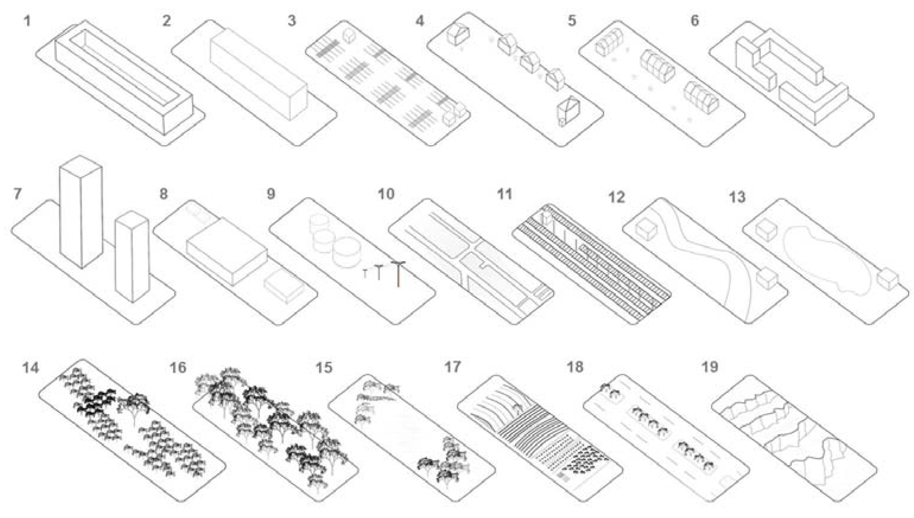
Examples of the UTS scheme of the 6th hierarchical level: (1) Perimeter blocks, (2) linear blocks, (3) extensive impervious surface, (4) single family-/semi-detached houses, (5) terraced houses, (6) multi-storey buildings, (7) high-rise buildings, (8) large industrial/retail, (9) special constructions, (10) streets, (11) railway constructions, (12) body of flowing water, (13) standing water body, (14) shrubs, (15) trees, (16) open vegetated space, (17) agriculture, (18) street accompanying green, (19) bare soil.
Figure 3.
Examples of the UTS scheme of the 6th hierarchical level: (1) Perimeter blocks, (2) linear blocks, (3) extensive impervious surface, (4) single family-/semi-detached houses, (5) terraced houses, (6) multi-storey buildings, (7) high-rise buildings, (8) large industrial/retail, (9) special constructions, (10) streets, (11) railway constructions, (12) body of flowing water, (13) standing water body, (14) shrubs, (15) trees, (16) open vegetated space, (17) agriculture, (18) street accompanying green, (19) bare soil.

Figure 4.
Remote sensing implementation scheme; introduction of the mechanistic level “mobile objects”.
Figure 4.
Remote sensing implementation scheme; introduction of the mechanistic level “mobile objects”.

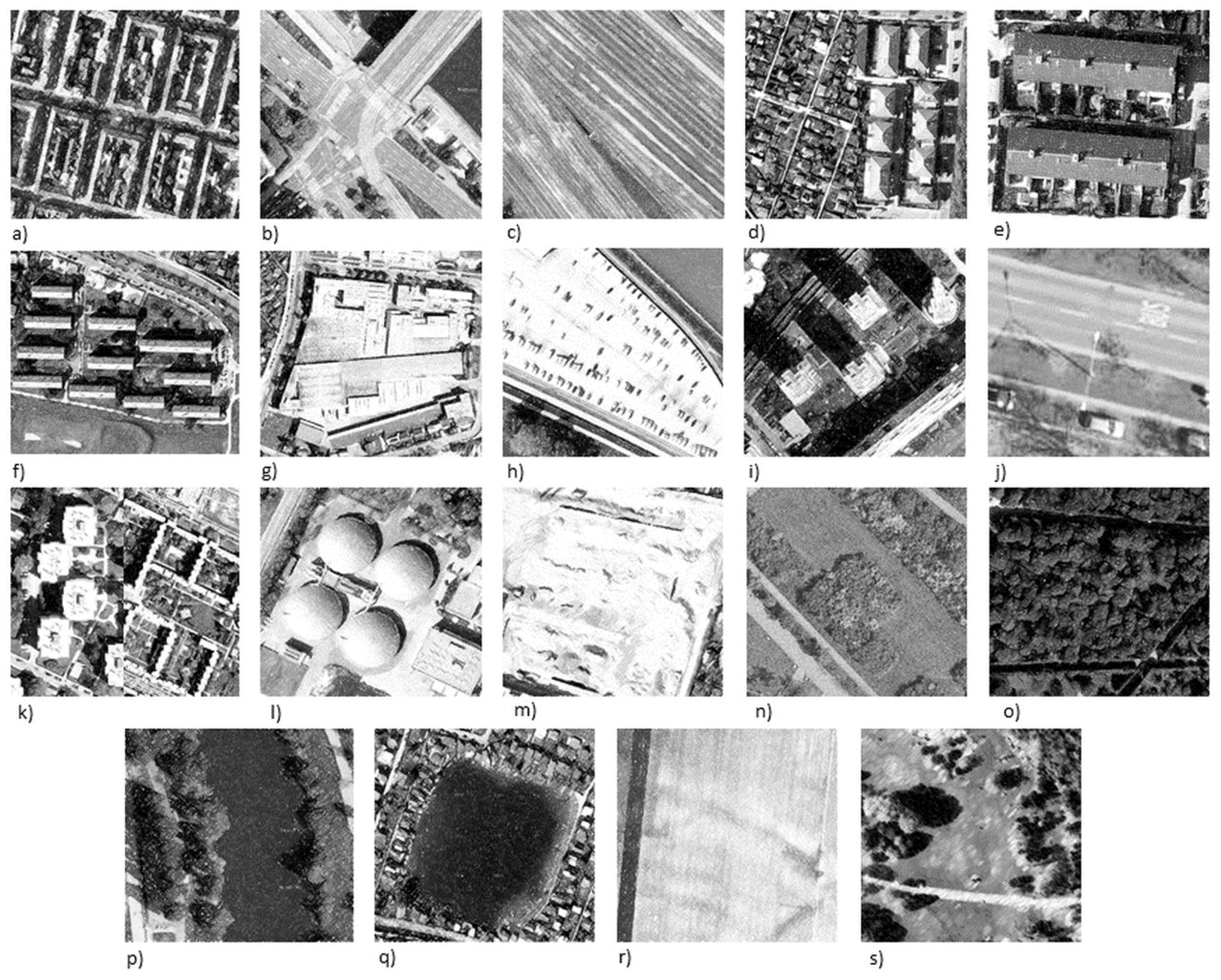
Figure 5.
Remotely sensed examples of the UTS scheme of the 6th hierarchical level: (a) Perimeter blocks, (b) streets, (c) railway constructions, (d) single family-/semi-detached houses, (e) terraced houses, (f) linear blocks, (g) large industrial/retail, (h) extensive impervious surface, (i) high-rise buildings, (j) street accompanying green, (k) multi-storey buildings, (l) bare soil, (m) special constructions, (n) shrubs, (o) trees, (p) body of flowing water, (q) standing water body, (r) agriculture, (s) open vegetated space. Source: Stadt Wien—data.wien.gv.at.


Table 1.
USTs proposed in the literature.
| Number of USTs | Proposed Urban Structure Type | Reference | Study Area | Used Remote Sensing Data |
|---|---|---|---|---|
| 18 | 1 Forests, parks and small green areas, cemeteries, uncultivated land, water bodies and water bodies’ accompanying green areas, public institutions, perimeter buildings, multi-storey buildings, old village centers and mixed areas, single-family houses and terraced houses, allotment, agricultural field, agricultural grassland, agricultural special crops and tree nurseries, industrial and commercial areas, railway tracks, streets and street accompanying green areas, separate use | [2] | Munich | Aerial images |
| 24 | Single- and semi-detached houses, terraced houses, multi-storey buildings, hall buildings and storage buildings, multi-storey and hall buildings, mixed buildings, special constructions, streets, large parking lots, railway tracks, gravel areas, sports facilities, standing water bodies, bodies of flowing water, forests, hedgerows and (urban-) woods, parks and green areas, cemeteries, extensive grassland and uncultivated land, meadows and pastures, crop land, agricultural special crops and tree nurseries | [25] | Munich | Aerial images |
| 15 | Discontinuous Wilhelmeanian style row houses with courtyard buildings, continuous Wilhelmeanian style row houses with courtyard buildings, discontinuous Wilhelmeanian style row houses, continuous Wilhelmeanian style row houses, apartment blocks, housing estates built after 1960, detached and semi-detached houses, industrial and commercial sites with high imperviousness, public buildings and service centers, shopping centers, transportation areas, parks and green spaces, community gardens/allotments, cemeteries, recreational areas | [24] | Leipzig | CIR aerial photographs |
| 5 | Industrial and commercial areas, inner city, urban area (dense buildings), suburban area (dispersed buildings), rural area (single buildings) | [26] | Zurich, Southampton | - |
| 10 | 1 Closed block development, open block development, linear block (traditional), linear block (industrial), high-rise building, single-family-/semi-detached house, terraced houses, rural-traditional building technique, industry/retail, special functional imprint | [27] | Bonn, Dresden | - |
| 27 | Shop house, informal shop house, shop house hotel, villa, modern villa, well-spaced apartments, highly-dense apartments, colonial, colonial block including shop houses, construction site, block under construction including shop houses, green open space (GOS), industry, industrial including shop houses, 1950/60s shop houses, high-rise (sic), shop houses and highly-dense apartments, shop houses adjoining green open spaces, shop houses and industry, shop houses and 1950&60s buildings, shop houses and high-rise (sic), informal shop houses and 1950/60s buildings, shop house hotel and well-spaced apartments, modern villa and highly-dense apartments, highly-dense apartment and high-rise (sic), colonial buildings adjoining GOS, colonial and high-rise (sic) | [28] | Ho Chi Minh City | Aerial photographs (?) |
| 10 (Germany), 5 (India) | Germany: detached house development, perimeter block development, mid-rise dwellings development, block development, high-rise building development, industrial areas, allotment gardens, major streets, ornamental lawns, sports areas; India: high quality urban fabric, medium quality urban fabric, low quality urban fabric, suburb, slum | [11] | Berlin, Dresden, Padang | Hyperspectral HyMap data, LiDAR data, aerial triangulation, Ikonos satellite imagery |
| 7 | 1 Single-/semi-detached house, linear block, perimeter block, multi-storey apartments, high-rise buildings, industrial/commercial, unclassified | [29] | Würzburg | Satellite sensor imagery (?) |
| 31 | City; surface water, green areas (consisting of: agricultural areas, green areas, woods and hedgerows), built-up areas (consisting of: housing construction, industrial built-up, traffic areas); housing construction (consisting of: dense built-up, loose built-up); dense built-up (consisting of: small multi-storey buildings, large multi-storey buildings, perimeter block development, dense block development, mix of various multi-storey buildings), loose built-up (consisting of: small semi-detached houses, detached and semi-detached houses, row house development, small freestanding multi-storey buildings, regular block development, row of houses linked together, high-rise buildings, old towns, mixed use area); industrial built-up (consisting of: large hall buildings, small hall buildings, special structures, mixed developments: small multi-storey & hall buildings, mixed developments: large multi-storey & hall buildings) | [30] | Munich | HRSC-AX (High Resolution Stereo Camera – Airborne Extended) optical imagery and photogrammetric DSM, IKONOS satellite imagery |
| 7 | Green spaces (parks & green areas), residential areas (single family houses, semi-detached standardized houses, social housing-row houses, building blocks with plenty of green spaces, buildings blocks of social housing, high-rise building complexes and mixed neighborhoods up to 20 storeys (sic) high | [31] | Santiago de Chile | Landsat satellite imagery, QuickBird satellite imagery, Aerial photographs |
| 9 | High density block development, perimeter block development, regular block development, row house development, detached and semi-detached houses, high-rise buildings, large halls and storage buildings, small halls and storage buildings, parks | [7] | Munich | HyMap (airborne hyperspectral imaging) imagery, SRTM (Shuttle Radar Topography Mission) |
| 5 | Residential buildings, public institutions, mixed industrial/commercial 1, mixed industrial/commercial 2, green-/open spaces | [21] | Distrito Federal do Brasíl | QuickBird satellite imagery |
| 9 | (MFH=Multifamily house; single/two-family house=SFH) MFH-closed, MFH-open, MFH-traditional rows, MFH-industrial rows, MFH-high rise, SFH-detached/semi-detached, SFH-terraced, SFH-rural, industrial/commercial usage, buildings with special purpose (e.g., public, education, health) | [12] | Dresden | - |
| 8 | Block development, perimeter block development, regular block development, row house development, detached and semi-detached housing, high-rise buildings, large multi-storey buildings, parks and urban green | [32] | Munich | Landsat satellite imagery, HyMap (airborne hyperspectral imaging) imagery Orthoimagery, Photogrammetric DEM |
| 5 | Industrial, center, block, single, allotment | [23] | Rostock | QuickBird satellite imagery, airborne LiDAR |
| 6 (15) | Residential and office blocks (block development, perimeter block development, row development, apartment block, high-rise buildings, semi-detached houses, mixed development) commercial and industrial areas, unvegetated open spaces (sealed areas, bare soil), green spaces (allotment gardens, parks, woodland) agricultural areas, water bodies | [20] | Berlin | airborne UltraCamX optical imagery and photogrammetric DSM |
| 1 (2) | Central business district (CBD) and non-central business district (Non-CBD) | [8] | London and Paris | Landsat satellite imagery, Cartosat-1 optical imagery & photogrammetric DSM |
| 5 (21) | Green areas (conservation units, green spaces, derelict spaces, urbanization), residential areas (very low density, low density, marginal, high density, medium density, high standard, very high standard, low building, low building-prime, high buildings), public areas (transportation, public building, recreation, commercial), commercial and industrial areas (commercial, industrial), mixed (commercial/residential, industrial/commercial/residential) | [1] | Distrito Federal do Brasíl | Orthoimagery |
| 8 | “UST 1-7” based on the relationships between the components of a vegetation-impervious-soil (V-I-S) model | [33] | Santiago de Chile | Landsat 5 & 8 satellite imagery, Images from Google Earth |
| 8 (including land use) | Water, public services, medium residence, low residence, industry, high residence, vegetation, bare soil | [34] | District of Abidjan | Landsat satellite imagery |
| 5 | Parks and vegetated areas, detached and semi-detached housing, large buildings and industrial areas, dense block development, regular block development | [9] | Munich | TerrarSAR-X Spotlight Imagery |
1 Translation from German into English.
Table 2.
Literature referring to the UST concept.
| Referring to the Urban Structure Type (UST) Concept Without Proposing Particular USTs | Sphere of Application |
|---|---|
| [35] | Soil sealing, rainwater management |
| [36] | Urban land use |
| [37] | Informal settlements |
| [38] | Landscape metrics, urban land use structures |
| [39] | Urban patterns and morphology |
| [40] | Local potential of district heat, settlement structures |
| [41] | Urban morphology analysis |
| [42] | Urban structure types, land use |
| [16] | Local Climate Zones, urban structure |
| [43] | Local Climate Zones, WUDAPT |
| [44] | Local Climate Zones, neighborhood information |
Table 3.
Requirements for optical remote sensing (RS) based classification of USTs.
| RS–Implementation Level | Resolution Demands | Potential Sensors | Recommended Spatial Resolution | Optical Data | 3D |
|---|---|---|---|---|---|
| I | Low resolution | MODIS (Terra, Aqua) | ≤250 m | x | |
| II | Mid-High resolution | Landsat 7/8, Aster, (Sentinel-1) | ≤30 m | x | |
| III | High resolution | Sentinel-2, Rapid Eye | ≤10 m | x | |
| IV | High resolution | SPOT-6/-7, Gaofen, IKONOS | ≤1.5 m | x | |
| V | Very high resolution | GeoEye 1, Quickbird, Pleíades | ≤0.65 m | x | x |
| VI | Very high resolution | WorldView 3/4, Orthophoto | ≤0.31 m | x | x |
© 2019 by the authors. Licensee MDPI, Basel, Switzerland. This article is an open access article distributed under the terms and conditions of the Creative Commons Attribution (CC BY) license (http://creativecommons.org/licenses/by/4.0/).
Share and Cite
MDPI and ACS Style
Lehner, A.; Blaschke, T. A Generic Classification Scheme for Urban Structure Types. Remote Sens. 2019, 11, 173. https://doi.org/10.3390/rs11020173
AMA Style
Lehner A, Blaschke T. A Generic Classification Scheme for Urban Structure Types. Remote Sensing. 2019; 11(2):173. https://doi.org/10.3390/rs11020173
Chicago/Turabian StyleLehner, Arthur, and Thomas Blaschke. 2019. "A Generic Classification Scheme for Urban Structure Types" Remote Sensing 11, no. 2: 173. https://doi.org/10.3390/rs11020173
Note that from the first issue of 2016, this journal uses article numbers instead of page numbers. See further details here.