Remote Sensing of Hydrological Changes in Tian-e-Zhou Oxbow Lake, an Ungauged Area of the Yangtze River Basin

1
Institute of Geodesy and Geophysics, Chinese Academy of Sciences, Wuhan 430077, China
2
Key Laboratory of Monitoring and Estimate for Environment and Disaster of Hubei Province, Wuhan 430077, China
*
Author to whom correspondence should be addressed.
†
The authors contributed equally to this work.
Remote Sens. 2018, 10(1), 27; https://doi.org/10.3390/rs10010027
Submission received: 28 September 2017
/
Revised: 12 December 2017
/
Accepted: 20 December 2017
/
Published: 25 December 2017
(This article belongs to the Special Issue Remote Sensing of Floodpath Lakes and Wetlands)
Abstract
:The hydrological pattern changes have a great influence on the wetland environment. However, some important wetland areas often lack historical observations due to economic and physical conditions. The Tian-e-Zhou oxbow lake wetland is an important habitat for two endangered species and also has very little historical hydrological data. Remote sensing images can be used to explore the historical water area fluctuation of lakes. In addition, remote sensing can also be used to obtain historical water levels based on the water boundary elevation integrated with a topographic data (WBET) method or the level-surface area relationship curve (LRC) method. In order to minimize the uncertainty of the derived results, both methods were introduced in the extraction of the water level of Tian-e-Zhou during 1992–2015. The results reveal that the hydrological regime of the oxbow lake has experienced a significant change after the Shatanzi Levee construction in 1998. With the impact of the levee, the mean annual water surface area of the lake was reduced by 5.8 km2 during the flood season, but, during the non-flood season, it was increased by 1.35 km2. For the same period, the water level of the lake during the flood season also showed a 1.47 m (WBET method) or 3.21 m (LRC method) decrease. The mean annual water level increased by 1.12 m (WBET method) or 0.75 m (LRC method). Both results had a good accuracy with RMSE (root-mean-square errors) of less than 0.4 m. Furthermore, the water level differences between the Yangtze River channel and the oxbow lake increased by at least 0.5 m. It is found that the hydrological pattern of the oxbow lake changed significantly after the levee construction, which could bring some disadvantages to the habitats of the two endangered species.
1. Introduction
The lower Jingjiang reach of the Yangtze River is known for its meanders with a high degree of channel sinuosity [1,2]. Due to a series of natural and artificial cut-offs since the 1880s, several oxbow lakes remain along the river bank on the floodplain [3,4]. With the implementation of some major water projects, including the Three Gorges Dam and the Gezhouba Dam [5,6], as well as river regulation and flood control projects [7,8], the hydrologic regime in the lower Jingjiang reach and the oxbow lakes have been greatly altered in recent decades.
In general, in-situ data obtained from gauged hydrological stations can be applied to analyze the hydrological changes in rivers and lakes. Limited by the underdeveloped infrastructure and the complex underlying surfaces, hydrological station networks in the middle reach of the Yangtze River Basin are sparse and poorly maintained [9,10,11]. In these ungauged basins and regions, especially in the oxbow lakes, historical or long-time series of hydrological data are either lacking or difficult to obtain. Given the lack of hydrologic data, the hydrologic changes caused by human activities have rarely been acknowledged in oxbow lakes. Nevertheless, many oxbow lakes in the middle reach of the Yangtze River Basin maintained abundant endangered species. For example, Père David’s deer (Elaphurus davidianus) and the Yangtze finless porpoise (Neophocaena asiaeorientalis). Despite the fact that hydrologic changes have a great influence on the habitats of these endangered species, no study has fully addressed the hydrologic changes in this area.
Owing to the development of satellite remote sensing technology, nearly every process of the terrestrial hydrological cycle can be observed/inferred directly or indirectly [12]. In particular, the measurement of water surface area and water level by remote sensing in ungauged areas has become more accurate and reliable. In addition, remote sensing can provide instantaneous “snapshots” of rivers and lakes, thus allowing the direct and convenient extraction of data regarding water surface area. Water level can be directly measured by using a radar altimeter and can be inferred by referring to some ground measurement data, such as the in-situ water level, discharge, or topographic data with water surface area [13,14]. However, the radar altimeter approach must ensure that the return echo data comes from water bodies instead of land [15]. The larger the water bodies are, the more echo data are returned, and the better the accuracy of the water surface elevation measurement [14]. As a consequence, the water level of rivers and some small bodies of water, such as oxbow lakes, cannot be measured directly by a radar altimeter. Remote sensing also provides two indirect approaches for water level extraction [13,16]: the water boundary elevation integrated with topographic data (WBET) method and the level–surface area relationship curve (LRC) method. The WBET method measures the water boundary line elevation integrated with ground topographic data. Through the WBET method, topographic maps and satellite images are used to obtain the water level data of the reservoirs [17] and rivers [18]. The LRC method correlates satellite-derived water surface area data with in situ water level data to construct an empirical rating curve. This method has also been widely employed in the extraction of the water level data in many water bodies [19,20].
In the present study, we focused on the application of remote sensing technology in determining the hydrologic pattern changes of an oxbow lake in the middle reach of the Yangtze River. Two remote sensing approaches (WBET and LRC methods) were applied to estimate the water level fluctuation in the ungauged oxbow lake. Then, the hydrologic pattern changes caused by human activities during 1992–2015 were analyzed. The specific aims of this study are as follows: (i) to verify the effectiveness of the remote sensing method in characterizing the hydrologic changes of ungauged ecological zones; and (ii) to quantitatively analyze the variation characteristics of hydrologic patterns in the Tian-e-Zhou oxbow lake due to the impact of human activities.
2. Study Area
A series of oxbow lakes have formed in the abandoned channel of the middle reach of the Yangtze River after the channel migration process. The Tian-e-Zhou wetland (112°31′N–112°37′N, 29°46′E–29°51′E) is a typical oxbow lake located at the north bank of the Yangtze River, adjacent to the south of the Jianghan (Yangtze–Han River) floodplain (Figure 1). Located about 180 km downstream of the Three Gorges Dam, this wetland was once a section of the middle reach of the Yangtze River before being separated from the main stream through natural realignment of the channel in 1972 [21]. This oxbow lake is approximately 21 km long. The width ranges from 1–2 km and the surface area varies from 10–20 km2 with the seasonal changes. The Tian-e-Zhou oxbow lake shown in Figure 1 is at its normal water level with a water surface area of approximately 16 km2. A subtropical monsoon climate prevails in this area and the average annual temperature and precipitation are 16.5 °C and 1200 mm, respectively. Due to its geological and meteorological conditions, this area is prone to constant flooding [7]. Therefore, to prevent floods, the well-known Great Jingjiang Levee and many other minor levees have been constructed along the middle reach of the Yangtze River Basin [4]. The hydrological connection in the flood season between the oxbow lake and the Yangtze River was absolutely cut off by the construction of the Shatanzi Levee in 1998. At present, the lake is only connected to the river channel by a narrow “cecum reach” and the Tian-e-Zhou sluice. We defined the minor levee around the oxbow lake as the boundary of the Tian-e-Zhou area. The upstream channel of the oxbow lake is entirely channelized and diked to control floods, and the rate of scouring and silting in the oxbow lake is very small.
Due to the successful reintroduction of Père David’s deer (Elaphurus davidianus) [22] and the ex situ conservation of the Yangtze finless porpoise (Neophocaena asiaeorientalis) [23], the Tian-e-Zhou oxbow lake has attracted increasing attention. The Yangtze finless porpoise (Neophocaena asiaeorientalis) is the world’s only freshwater porpoise. It was classified as Endangered in 1996 and raised to Critically Endangered in 2013 on the International Union for Conservation of Nature (IUCN) Red List of Threatened Species. Père David’s deer (Elaphurus davidianus) is listed as Extinct in the Wild on the IUCN Red list. The two national natural reserves are present in the oxbow lake to protect these endangered species. The numbers of these species in the two reserves account for 20% and 5.8%, respectively, of the total population in the world [24,25]. Hydrological changes caused by the drastic channel migrations and intensive human activities have a significant influence on the ungauged habitats of these two endangered species.
3. Data and Methods
3.1. Data Collection and Processing
The satellite imageries of the Landsat Thematic Mapper (TM), the Enhanced TM Plus (ETM+) and the Operational Land Imager (OLI) were employed in this study to determine the water surface area of the Tian-e-Zhou Oxbow Lake. The 108 satellite images from 1992–2015 (including 11 Landsat 7 ETM+ scan-line corrector (SLC)-off images) used in this study were obtained from the Earth Explorer Interface of the United States Geological Survey (USGS) (http://earth explorer.usgs.gov/). The strategy used for geometric correction was image-to-image registration, and the root-mean-square errors (RMSEs) of correction were all less than 30 m. All of the images used were cloud free or had a small cloud cover in the study area. The SLC of the Landsat 7 ETM+ sensor failed in 2003 which resulted in wedge-shaped gaps and missing pixels in the images [26]. Therefore, we used a simple gap-filling extension toolbox (landsat_gapfill.sav) in the software of ENVI (version 4.3, Research Systems Inc., Boulder, CO, USA) to remove the gaps. This gap-filling method is based on a commonly used technique by the USGS in local linear histogram matching [27].
We defined the daily water level of the Jianli Gauging Station (approximately 20 km away from the Tian-e-Zhou oxbow lake) as the water level of the Yangtze River. The ground measurement water level of the oxbow lake in 2010–2012 was provided by the administrative office of the Yangtze Finless Porpoise National Nature Reserve for our verification. Data sets in 2011 and 2012, including 14 remotely sensed images, were used in fitting the surface area–water level curve of the LRC method. In-situ water level data in 2010 were used to validate the performance of the two remote sensing methods. Monthly precipitation and evapotranspiration data from 1992–2015 of the Jianli Weather Station (approximately 20 km away from the Tian-e-Zhou oxbow lake) were obtained from the China Meteorological Data Service Centre to examine the long-term changes in meteorological conditions in this area.
Compared with classification, spectrum photometry and density-slicing approaches, the normalized difference water index (NDWI) can produce the best results to delineate the water areas [28,29]. The NDWI used in this study was developed by McFeeters (1996) [30]. The NDWI is expressed as:
where Green and NIR represent the reflectance in the green and near-infrared channels, respectively.
The water bodies were obtained by the threshold extraction method based on the NDWI values. Visual interpretation was then conducted to define the threshold value and minimize the minor error to ensure the accuracy of the water surface extraction. The water surface area and water boundary line were then extracted. The centerline of the oxbow lake was derived as the channel length from the water boundary line by using the mathematical morphology method [31]. The inundation frequency was calculated using the number of inundation images divided by the number of derived images in each pixel. It describes the probability of water submerge. The area ratio is the percentage value of the total area under different inundation frequencies. The water storage was calculated by accumulating the volume of each pixel with the Area and Volume Statistics module in Arc Map ( version 10.0. Esri, Redlands, CA, USA) The time series was divided into two distinguishable periods, namely, 1992–1998 and 1999–2015, according to the construction of the Shatanzi Levee.
3.2. Water Level Data Extraction and Results Validation
To ensure the stability of water level data extraction in this study, the remote sensing approaches of the WBET and LRC methods were utilized to extract the data from the Tian-e-Zhou oxbow lake. For the WBET method, highly accurate topographic data were required. Sonar sensors on ships in transects and global positioning system-real-time kinematic (GPS-RTK) technology was used for the underwater and beach wetland topographic surveys conducted in December 2009 and September 2014, respectively. The discrete height point data in Tian-e-Zhou were obtained from GPS-RTK technology, and the kriging interpolation method (KIM) was utilized to obtain a highly accurate digital elevation model (DEM) in the area. The extracted water boundary line was overlaid onto the DEM and the average elevation of the water boundary was defined as the water level (Figure 2). Given that many minor levees around the oxbow lake obstructed the water level fluctuation, only the water boundary on the beach wetland with a gently sloping relief could be selected. Finally, the mean elevation value of the water boundary could be regarded as the water level used here.
Generally, there exists a strong linear correlation between water surface area and water level for many lakes [13]. For the LRC method, the area-based water level can be estimated by constructing empirical rating curves that relate the satellite-derived surface area to ground measurements of the water level. According to the measurements and calculations of the water surface area, we obtained an equation in which the water level varies with the surface area. The water level in the oxbow lake was calculated by using this equation.
The RMSE, Pearson’s correlation coefficients (R), and mean relative error (MRE), were calculated to validate the two water level data extraction methods. They are respectively expressed as:
where is the water level measured by the two methods, is the ground measurement water level, is the mean value of , is the mean value of , and n is the number of total data.
4. Results
4.1. Water Level Data Extracted from the Two Methods and Their Comparison
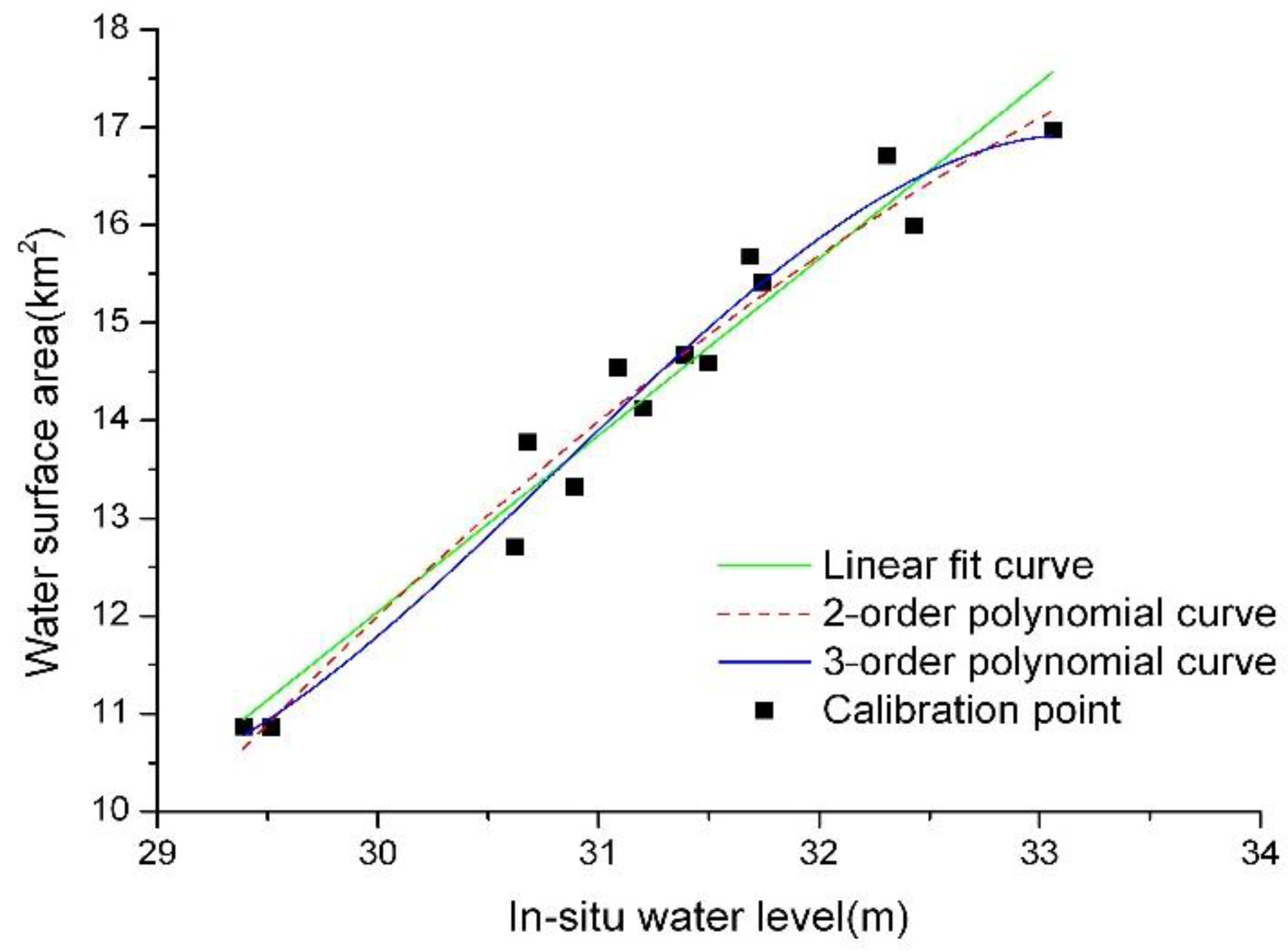
Given the highly correlated relationship between the water surface area and the in situ water levels in the oxbow lake, the water surface area–lake level fitting curves were constructed. Three fitting curves were constructed by using the LRC method, as shown in Figure 3. The results show that all of the curves produced a good fit for the relationship between the water level and the lake surface area in the Tian-e-Zhou oxbow lake (Table 1). Even a simple linear fitting curve can be used for the water level data extraction with an RMSE of 0.219 m and an R-squared value of 0.949. The lake water levels at other times could then be estimated using this empirical model.
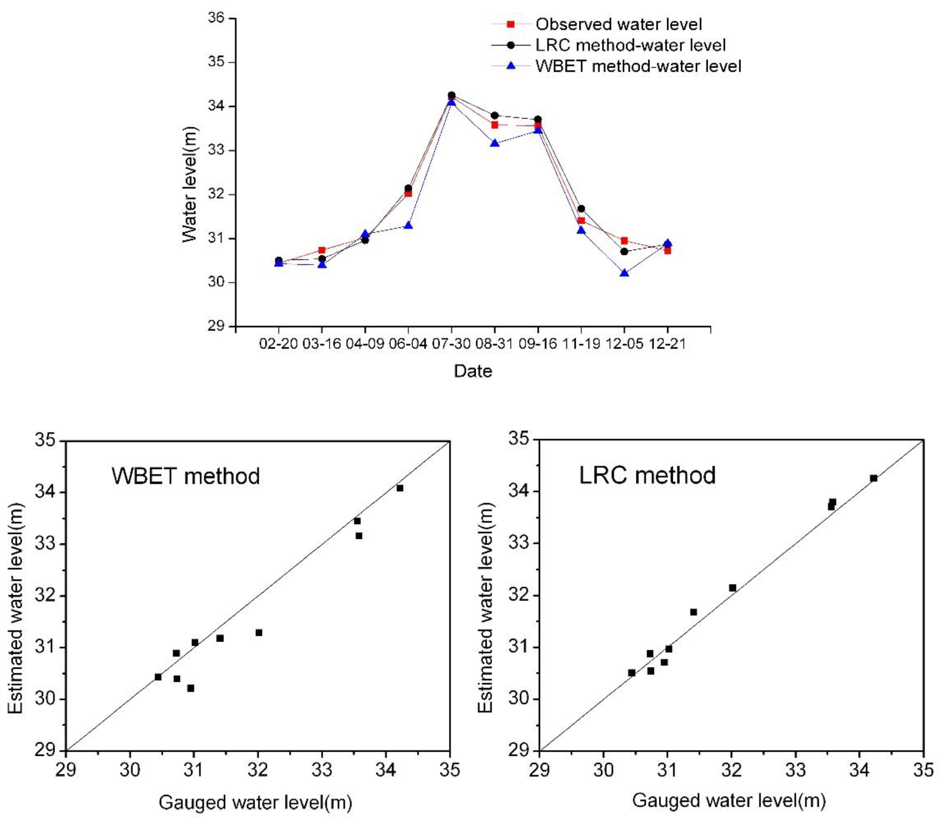
We used in-situ measurements of water level data (10 points) in 2010 to validate the observed results and confirm the accuracy of the two methods. The temporal comparison of the two methods with the observed data is shown in Figure 4. The quality indicators, including assessments of RMSE, MRE, and R, are shown in Table 2. The results indicated that the two methods exhibited a good agreement with the in situ data (red line in Figure 4) during the comparison time span. The LRC method maintained RMSE and R values of 0.168 m and 0.994, respectively, whereas the WBET method had RMSE and R values of 0.386 m and 0.975, respectively (Table 2). The small errors and high correlation coefficients indicated the feasibility of the two methods in estimating the water level in the oxbow lake.
4.2. Hydrologic Pattern Changes in the Oxbow Lake
The change trends of water level and water surface areas in the oxbow lake are illustrated in Figure 5. During the period of 1992–2015, the water level in the oxbow lake fluctuated widely from 28.54 m to 35.12 m (WBET method) or from 29.34 m to 39.97 m (LRC method), with the water surface area varying from 10.86 km2 to 30.06 km2 (Figure 5a,d). The flood and drought disaster events that occurred in this basin during the observed period were clearly shown, such as the serious flood in the summer of 1998, the drought in 2004, and the sudden turn of drought and flood in the spring and summer of 2011 [32]. The results of the two methods show that the water level and the water surface area in the flood season (from June–September) of the oxbow lake displayed statistically significant decreasing trends (95% confidence level and P < 0.05) between 1992 and 2015 (Figure 5b,e). On the contrary, the water level in the non-flood season (from October–May) displayed a slightly increasing trend (Figure 5c,f). In general, the fluctuation range of the water level and the water surface area decreased during the observed period.
After the great flood of the whole Yangtze River Basin in 1998, the Shatanzi Levee was constructed to prevent further flooding in this area. As a result, the hydrological conditions, including water surface area and water level, have been significantly altered. The maximum and minimum water surface areas in the periods of 1992–1998 and 1999–2015 were calculated in this study. The results showed that the maximum water surface area in the two periods both occurred in August. The maximum water surface areas in 1992–1998 and 1999–2015 occupied approximately 76.1% and 61.6% of the whole Tian-e-Zhou area, respectively (Figure 6). The area difference between the maximum and minimum water surface areas decreased from 19.2 km2 in 1992–1998 to 12.3 km2 in 1999–2015.
Changes in the average annual water level, the water surface area, and the water level difference with the Yangtze River before and after 1998 were all calculated. The results showed that the mean annual water level during the flood season in the oxbow lake decreased by 1.47 m (WBET method) or by 3.21 m (LRC method); the mean annual water surface area decreased by 5.8 km2. By contrast, the mean annual water level increased by 1.12 m (WBET method) or by 0.75 m (LRC method) and the mean annual water surface area decreased by 1.35 km2 during the non-flood season (Table 3). The two methods showed the same change trends. The water level in the oxbow lake increased with the Yangtze River, and the water level difference between them was small before 1998. However, the mean water level difference between the Yangtze River and the oxbow lake increased from 1.68 m in 1992–1998 to 3.32 m in 1999–2015 (WBET method) or from 3.19 m to 3.69 m (LRC method).
The inundation frequency was also analyzed in the current study by overlaying the images of all bodies of water to verify the decreasing trend of water levels in this area, especially after 1998. The result indicated that the average inundation frequencies decreased from 52.2% in 1992–1998 to 50.7% in 1999–2015 (Figure 7). The area with a low inundation frequency (0–25%) occupied 59.28% of the total area in 1992–1998. However, the area ratio increased to 68.7% in 1999–2015. Furthermore, the area ratio with an inundation frequency (25–75%) decreased from 17.48% in 1992–1998 to 5.75% in 1999–2015.
5. Discussion
5.1. Uncertainty Analysis of the Water Level Estimation
The errors and uncertainties associated with Landsat imageries and DEM directly contributed to the errors in the water level extraction. The first cause of this was because of the error in the extracted water boundary line due to the fact that two methods were needed to utilize the surface area. In this study, the water boundary was extracted using NDWI with a threshold value by visual interpretation. The pixel resolution of the used imageries was 30 m × 30 m, and the pixels located in the water and land boundaries were often mixed pixels [33]. An accurate surface area would have been able to be extracted if a high resolution satellite image was used. Although we modified the minor error of the water surface area extracted by visual interpretation, the error still remained. Thin cloud cover and SLC-off imageries might have led to the errors of surface area extraction. The other error source was from the uncertainty of the DEM data. DEM errors generally come from two sources: elevation data and altitude interpolation [34]. Although sufficient ground and underwater altimetric points were utilized by the KIM to generate the DEM in this study, the vertical inaccuracy caused by the ground measurement and interpolation could not be avoided. Some small man-made levees on the beach wetland might also be another important factor affecting the accuracy of the water level extraction. Furthermore, the terrain slope of the beach wetland could also change, which could also cause some errors.
Although the resolution of the DEM for the WBET method is high enough, the resolution of water boundary line extracted from satellite images was rather coarse (30 m × 30 m) to use for the WBET method. Thus, it is difficult to obtain results that are as good as those obtained through the LRC method. Moreover, higher resolution satellite images can lead to better and more accurate results. The average value of the extracted points of the WBET method might also cause some errors in the results. Despite the fact that the LRC method performed better than the WBET method, overall, the uncertainty of the LRC method still exists. In the LRC method, the water level was estimated from a lake level–surface area rating curve, and the uncertainty involved in this curve inevitably affected the results. Due to the randomness of the lake landform, it became more difficult to use the standard curve in describing the relationship between water surface area and water level.
The small RMSE and high correlation coefficients compared with the in situ data indicated the feasibility of the two remote sensing methods in conducting water level extraction of the Tian-e-Zhou oxbow lake. They exhibited a similar change trend of water level in the lake, which verified the credibility of the results. Given the effective application of remote sensing in the Tian-e-Zhou oxbow lake, the hydrologic change in other ungauged oxbow lakes can also be measured.
5.2. Reason and Influence Analysis of Hydrologic Pattern Changes
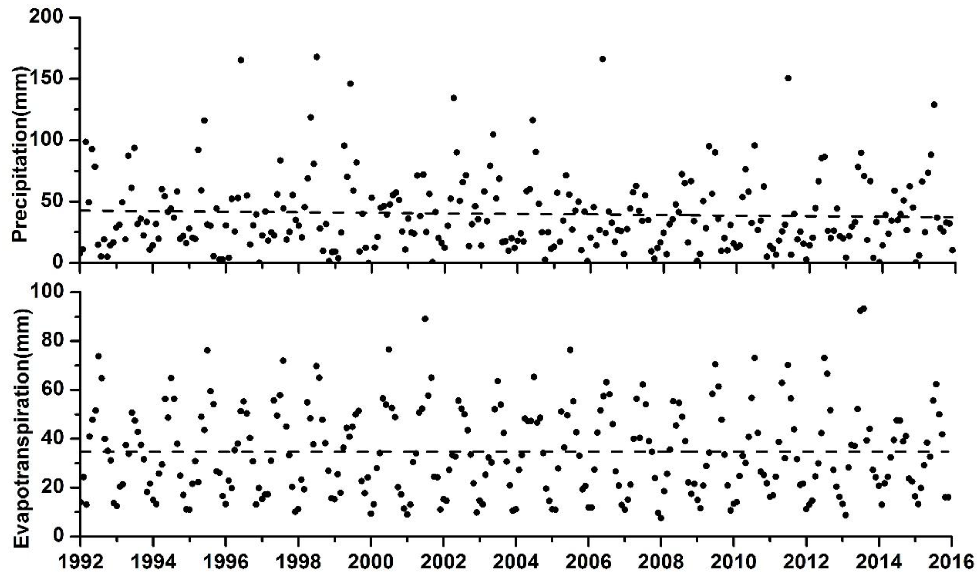
Climate conditions could be one of the main reasons of the water level fluctuation and the water surface area variation in a lake or river [35,36]. However, when examining the long-term mean monthly precipitation and evapotranspiration data in the Jianli Meteorological Station from 1992–2015, the two most important natural factors did not show an obvious synchronous change with the water level and the water surface area (Figure 8).
With the operation of the Three Gorges Reservoir in the upstream, the erosion of the river channel near the oxbow lake became aggravated, resulting in the channel’s mean scour depth of 2–3 m [4,37]. Thus, the water level in the Yangtze River channel decreased and the bank failure risks also increased. The recovery of the hydrologic connectivity between the Yangtze River and oxbow lake has become increasingly difficult. From the analysis results, the influences of river-lake isolation on the hydrologic pattern changes are more obvious than those of the Three Gorges Dam and the climate conditions. Many past studies have shown that intensive levees and revetments have been constructed in this area to prevent floods since the Ming Dynasty, and that the relationships between the Yangtze River and surrounding lakes have been significantly changed [4,38]. The isolation from the Yangtze River through the creation of man-made levees should account for the hydrologic changes in the oxbow lake. After being separated from the Yangtze River by the Shatanzi Levee in 1998, the water level in the flood season and the fluctuation frequency decreased in the oxbow lake [39,40]. However, given that the terrain of the beach wetland is relatively flat, a small decrease in water level can lead to a large decrease in water surface and a large increase in beach wetland. Consequently, the inundation frequency of beach wetland has decreased and the exposure time has become longer after 1998. Thus, the beach wetland has great potential to be influenced by human disturbances, such as agricultural activities and the planting of Italian poplar (Populus euramevicana) [41].
The changes in habitat caused by the hydrological alteration have largely affected the two endangered species living in the Tian-e-Zhou oxbow lake. With the decreasing water levels and inundation frequencies, the hygrophytes and aquatic plants, which are the major food sources of Père David’s deer (Elaphurus davidianus), can gradually be replaced with mesophytes and xerophytes [42]. The entire habitat of beach wetland went through a succession that apparently changed from a wet environment to a xeric environment. Hence, the biomass of plants which Père David’s deer (Elaphurus davidianus) preferred to eat, also decreased by 40% [43]. With the decrease in water level, the water storage of the oxbow lake also decreased. We calculated that the total average annual water storage decreased from 1.639 × 10⁸ m3 in 1992–1998 to 1.382 × 10⁸ m3 in 1999–2015. As a result, this has led to the compressed living spaces and the shortage of forage fishes for the Yangtze finless porpoises (Neophocaena asiaeorientalis) [44]. With the decreasing water level and water surface area, the habitats of Père David’s deer (Elaphurus davidianus) and the sources of food for the Yangtze finless Porpoise (Neophocaena asiaeorientalis) have been significantly changed. All of these phenomena go against the protection efforts made for the species maintained in the area. The oxbow lake may disappear, and the endangered species in the lake may have to seek new ex situ reserves to continue living.
6. Conclusions
In this study, two water level extraction methods based on remotely sensed data were applied to the ungauged area of Tian-e-Zhou Oxbow Lake. The two methods exhibited good performance in the extraction of water level data from such an ungauged area. Both methods exhibited a small RMSE within 0.4 m and a high correlation coefficient above 0.97. The hydrological pattern changes in the oxbow lake from 1992–2015, especially before and after the construction of the Shatanzi Levee in 1998, were analyzed. The results showed that the mean annual water level during the flood season in the oxbow lake decreased by 1.47 m (WBET method) or by 3.21 m (LRC method); the mean annual water surface area decreased by 5.8 km2. By contrast, the annual water level increased by 1.12 m (WBET method) or by 0.75 m (LRC method) and the mean annual water surface area decreased by 1.35 km2 during the non-flood season. The water level fluctuation in the oxbow lake thus became weak. The water level difference between the Yangtze River and the oxbow lake increased by 1.64 m (WBET method) or by 0.5 m (LRC method) but the inundation frequency decreased by 1.5% after 1998. The results verified that remote sensing methods can be used to characterize the hydrologic changes of ungauged oxbow lakes. The results demonstrate the hydrologic pattern changes and the series of ecological impacts caused by human activities in the oxbow lakes of the middle reach of the Yangtze River Basin.
Acknowledgments
This work was supported by the National Nature Science Foundation of China (Grant No. 41571202, 41171426 and 41331174). We thank the administrative office of the Yangtze Finless Porpoise National Nature Reserve for providing the underwater and beach wetland topographic data.
Author Contributions
Chao Yang, Xiaobin Cai, and Xuelei Wang conceived and designed the study. C.Y. and X.C. made substantial contributions to acquisition, analysis and interpretation of the data. The manuscript was written by C.Y. with contributions from all authors. All authors read and approved the submitted manuscript, agreed to be listed and accepted the version for publication.
Conflicts of Interest
The authors declare no conflict of interest.
References
- Wang, S.; Chen, Z.; Smith, D.G. Anastomosing river system along the subsiding middle Yangtze River Basin, southern China. Catena 2005, 60, 147–163. [Google Scholar] [CrossRef]
- Shao, X.; Wang, H.; Wang, Z. Fluvial processes in the Lower Jingjiang River: Impact of the Three Gorges Reservoir impoundment. Int. J. Sediment Res. 2005, 20, 102. [Google Scholar]
- Wang, Z.; Chen, Z.; Li, M.; Chen, J.; Zhao, Y. Variations in downstream grain-sizes to interpret sediment transport in the middle-lower Yangtze River, China: A pre-study of Three-Gorges Dam. Geomorphology 2009, 113, 217–229. [Google Scholar] [CrossRef]
- Yang, C.; Cai, X.; Wang, X.; Yan, R.; Zhang, T.; Zhang, Q.; Lu, X. Remotely sensed trajectory analysis of channel migration in lower Jingjiang reach during the period of 1983–2013. Remote Sens. 2015, 7, 16241–16256. [Google Scholar] [CrossRef]
- Jiang, L.; Ban, X.; Wang, X.; Cai, X. Assessment of hydrologic alterations caused by the Three Gorges Dam in the middle and lower reaches of Yangtze River, China. Water 2014, 6, 1419–1434. [Google Scholar] [CrossRef]
- Li, Q.; Yu, M.; Lu, G.; Cai, T.; Bai, X.; Xia, Z. Impacts of the Gezhouba and Three gorges Reservoirs on the sediment regime in the Yangtze River, China. J. Hydrol. 2011, 403, 224–233. [Google Scholar] [CrossRef]
- Yin, H.; Liu, G.; Pi, J.; Chen, G.; Li, C. On the river–lake relationship of the middle Yangtze Reaches. Geomorphology 2007, 85, 197–207. [Google Scholar] [CrossRef]
- Chuntian, C. Fuzzy optimal model for the flood control system of the upper and middle reaches of the Yangtze River. Hydrol. Sci. J. 1999, 44, 573–582. [Google Scholar] [CrossRef]
- Ibrahim, B.; Wisser, D.; Barry, B.; Fowe, T.; Aduna, A. Hydrological predictions for small ungauged watersheds in the Sudanian zone of the Volta Basin in west Africa. J. Hydrol. Reg. Stud. 2015, 4 Pt B, 386–397. [Google Scholar] [CrossRef]
- Dai, S.B.; Lu, X.X. Sediment deposition and erosion during the extreme flood events in the middle and lower reaches of the Yangtze River. Quat. Int. 2010, 226, 4–11. [Google Scholar] [CrossRef]
- Zhou, Y.; Jeppesen, E.; Li, J.; Zhang, Y.; Zhang, X.; Li, X. Impacts of Three Gorges Reservoir on the sedimentation regimes in the downstream-linked two largest Chinese freshwater lakes. Sci. Rep. 2016, 6, 35396. [Google Scholar] [CrossRef] [PubMed]
- Lakshmi, V. The role of satellite remote sensing in the prediction of ungauged basins. Hydrol. Process. 2004, 18, 1029–1034. [Google Scholar] [CrossRef]
- Smith, L.C. Satellite remote sensing of river inundation area, stage, and discharge: A review. Hydrol. Process. 1997, 11, 1427–1439. [Google Scholar] [CrossRef]
- Alsdorf, D.E.; Rodríguez, E.; Lettenmaier, D.P. Measuring surface water from space. Rev. Geophys. 2007, 45, 2637–2655. [Google Scholar] [CrossRef]
- Chu, Y.; Li, J.; Jiang, W.; Zou, X.; Fan, C.; Xu, X.; Dadzie, I. Monitoring level fluctuations of the lakes in the Yangtze River Basin from radar altimetry. Terr. Atmos. Ocean. Sci. 2008, 19, 63–70. [Google Scholar] [CrossRef]
- Schumann, G.; Bates, P.D.; Horritt, M.S.; Matgen, P.; Pappenberger, F. Progress in integration of remote sensing-derived flood extent and stage data and hydraulic models. Rev. Geophys. 2009, 47, RG4001. [Google Scholar] [CrossRef]
- Tseng, K.H.; Shum, C.K.; Kim, J.W.; Wang, X. Integrating landsat imageries and digital elevation models to infer water level change in Hoover Dam. IEEE J. Sel. Top. Appl. Earth Obs. Remote Sens. 2016, 9, 1696–1709. [Google Scholar] [CrossRef]
- Brakenridge, G.R.; Knox, J.C.; Paylor, E.D., II; Magilligan, F.J. Radar remote sensing aids study of the great flood of 1993. Earth Space Sci. News 1994, 75, 521–527. [Google Scholar] [CrossRef]
- Cai, X.; Gan, W.; Ji, W.; Zhao, X. Optimizing remote sensing-based level—Area modeling of large lake wetlands: Case study of Poyang Lake. IEEE J. Sel. Top. Appl. Earth Obs. Remote Sens. 2015, 8, 471–479. [Google Scholar] [CrossRef]
- Pan, F.; Liao, J.; Li, X.; Guo, H. Application of the inundation area—Lake level rating curves constructed from the SRTM DEM to retrieving lake levels from satellite measured inundation areas. Comput. Geosci. 2013, 52, 168–176. [Google Scholar] [CrossRef]
- Wang, T.; Wang, H.S.; Sun, G.W.; Huang, D.; Shen, J.H. Length-weight and length-length relationships for some Yangtze river fishes in Tian-e-zhou oxbow, China. J. Appl. Ichthyol. 2012, 28, 660–662. [Google Scholar] [CrossRef]
- Jiang, Z.; Yu, C.; Feng, Z.; Zhang, L.; Xia, J.; Ding, Y.; Lindsay, N. Reintroduction and recovery of Père David’s deer in China. Wildl. Soc. Bull. 2000, 28, 681–687. [Google Scholar]
- Wang, D. Population status, threats and conservation of the Yangtze finless porpoise. Chin. Sci. Bull. 2009, 54, 3473–3484. [Google Scholar] [CrossRef]
- Mei, Z.; Zhang, X.; Huang, S.L.; Zhao, X.; Hao, Y.; Zhang, L.; Qian, Z.; Zheng, J.; Wang, K.; Wang, D. The Yangtze finless porpoise: On an accelerating path to extinction? Biol. Conserv. 2014, 172, 117–123. [Google Scholar] [CrossRef]
- Jiang, Z.; Li, C.W.; Yang, D.D.; Zeng, Y.; Fang, H.X. Père david deer in China: Current status and conservation strategies. In Proceedings of the 20th Annuversary of Milu Returning Dafeng; Nanjing Normal University Press: Nanjing, China, 2008; pp. 1–14. [Google Scholar]
- Chen, J.; Zhu, X.; Vogelmann, J.E.; Gao, F.; Jin, S. A simple and effective method for filling gaps in Landsat ETM+ SLC-off images. Remote Sens. Environ. 2011, 115, 1053–1064. [Google Scholar] [CrossRef]
- Scaramuzza, P.; Micijevic, E.; Chander, G. Slc Gap-Filled Products Phase One Methodology. Available online: http://landsat.usgs.gov/documents/L7SLCGapFilledMethod.pdf (accessed on 12 January 2017).
- Hui, F.; Xu, B.; Huang, H.; Yu, Q.; Gong, P. Modelling spatial-temporal change of Poyang lake using multitemporal Landsat imagery. Int. J. Remote Sens. 2008, 29, 5767–5784. [Google Scholar] [CrossRef]
- Jain, S.K.; Singh, R.; Jain, M.; Lohani, A. Delineation of flood-prone areas using remote sensing techniques. Water Resour. Manag. 2005, 19, 333–347. [Google Scholar] [CrossRef]
- McFeeters, S. The use of the normalized difference water index (NDWI) in the delineation of open water features. Int. J. Remote Sens. 1996, 17, 1425–1432. [Google Scholar] [CrossRef]
- Guo, B.M.; Wang, T.; Zhao, R. Research on extracting skeleton line of polygon. In Proceedings of the 2nd IEEE International Conference on Information Management and Engineering (ICIME), Chengdu, China, 16–18 April 2010; pp. 514–517. [Google Scholar]
- Shen, B.; Zhang, S.; Yang, H.; Wang, K.; Feng, G. Analysis of characteristics of a sharp turn from drought to flood in the middle and lower reaches of the Yangtze River in spring and summer in 2011. Acta Phys. Sin. 2012, 61, 109202. [Google Scholar]
- Ling, F.; Cai, X.; Li, W.; Xiao, F.; Li, X.; Du, Y. Monitoring river discharge with remotely sensed imagery using river island area as an indicator. J. Appl. Remote Sens. 2012, 6, 063564. [Google Scholar] [CrossRef]
- Wise, S.M. The effect of GIS interpolation errors on the use of digital elevation models in geomorphology. Landf. Monit. Model. Anal. 1998, 99, 139–164. [Google Scholar]
- Sakamoto, T.; Van Nguyen, N.; Kotera, A.; Ohno, H.; Ishitsuka, N.; Yokozawa, M. Detecting temporal changes in the extent of annual flooding within the Cambodia and the Vietnamese Mekong delta from modis time-series imagery. Remote Sens. Environ. 2007, 109, 295–313. [Google Scholar] [CrossRef]
- Brivio, P.; Colombo, R.; Maggi, M.; Tomasoni, R. Integration of remote sensing data and GIS for accurate mapping of flooded areas. Int. J. Remote Sens. 2002, 23, 429–441. [Google Scholar] [CrossRef]
- Han, J.; Sun, Z.; Huang, Y.; Li, Y. Features and causes of sediment deposition and erosion in Jingjiang reach after impoundment of the Three Gorges Project. J. Hydraul. Eng. 2014, 45, 277–295. [Google Scholar]
- Yin, H.; Li, C. Human impact on floods and flood disasters on the Yangtze River. Geomorphology 2001, 41, 105–109. [Google Scholar] [CrossRef]
- Yin, R.L. Effect of lower-Jingjiang river evolution on Tianezhou natural protect area and countermeasures. J. Yangtze River Sci. Res. Inst. 2006, 23, 1–4. [Google Scholar]
- Zhu, Y.; Liao, W.; Feng, S. Study on the physical habitat characteristics of Yangtze finless porpoise in Tian-e-zhou oxbow of Yangtze river. J. China Inst. Water Resour. Hydropower Res. 2012, 10, 158–191. [Google Scholar]
- Zhang, Y.; Wang, M.; Xiao, Z.; Tang, Y.; Fang, F.; Li, P.; Liu, S. Land use dynamic change analysis based on “3s” technology in Shishou David’s deer national nature reserve. For. Inventory Plan. 2013, 38, 16–20. [Google Scholar]
- Yang, D.; Li, M.; Cheng, Y.; Wen, H.; Li, P.; Xu, F.; Li, W. Quantitative classification and ordination of wetland vegetations in oxbows, Yangtze River. Plant Sci. J. 2011, 29, 467–473. [Google Scholar]
- Li, P.; Yang, T.; Zhang, Y.; Cai, J.; Sha, P.; Wang, J. Habitats of edible plants for wild Milu population in Shishou and its restoration approach. J. Yangtze Univ. 2015, 12, 48–50. [Google Scholar]
- Ni, Z. Environmental and Ecological Impact Assessment of Rivers and Lakes Connection; Yangtze River Fisheries Research Institute, Chinese Academy Of Fishery Sciences: Wuhan, China, 2006. [Google Scholar]
Figure 1.
The location of the Tian-e-Zhou oxbow lake in the middle reach of the Yangtze River.
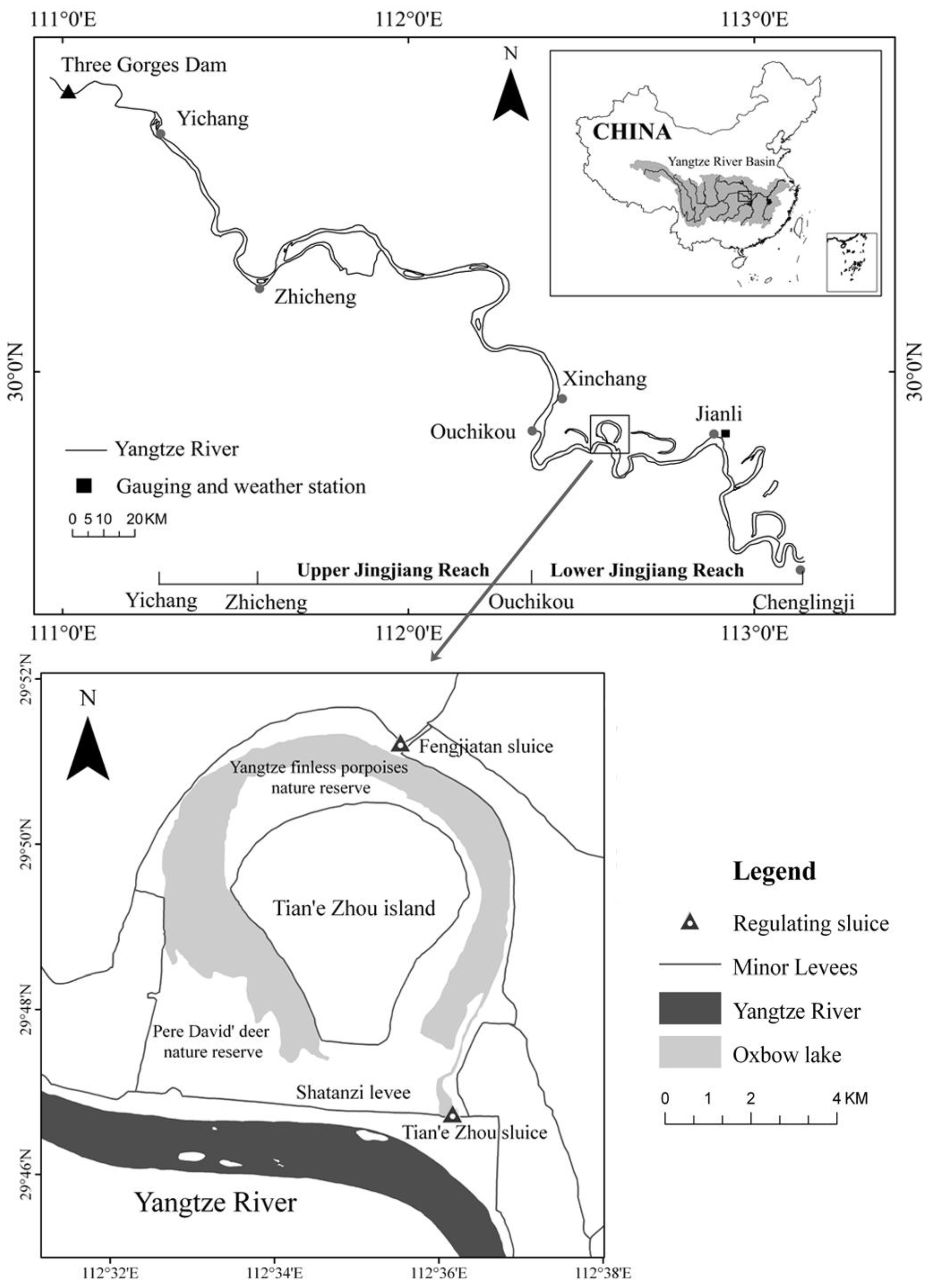
Figure 2.
A flowchart of the water level data extraction in the oxbow lake on 1 July 2011, by using the WBET method (the average elevation of vertices on the water boundary is regarded as the water level on 1 July 2011, namely 31.44 m).
Figure 2.
A flowchart of the water level data extraction in the oxbow lake on 1 July 2011, by using the WBET method (the average elevation of vertices on the water boundary is regarded as the water level on 1 July 2011, namely 31.44 m).
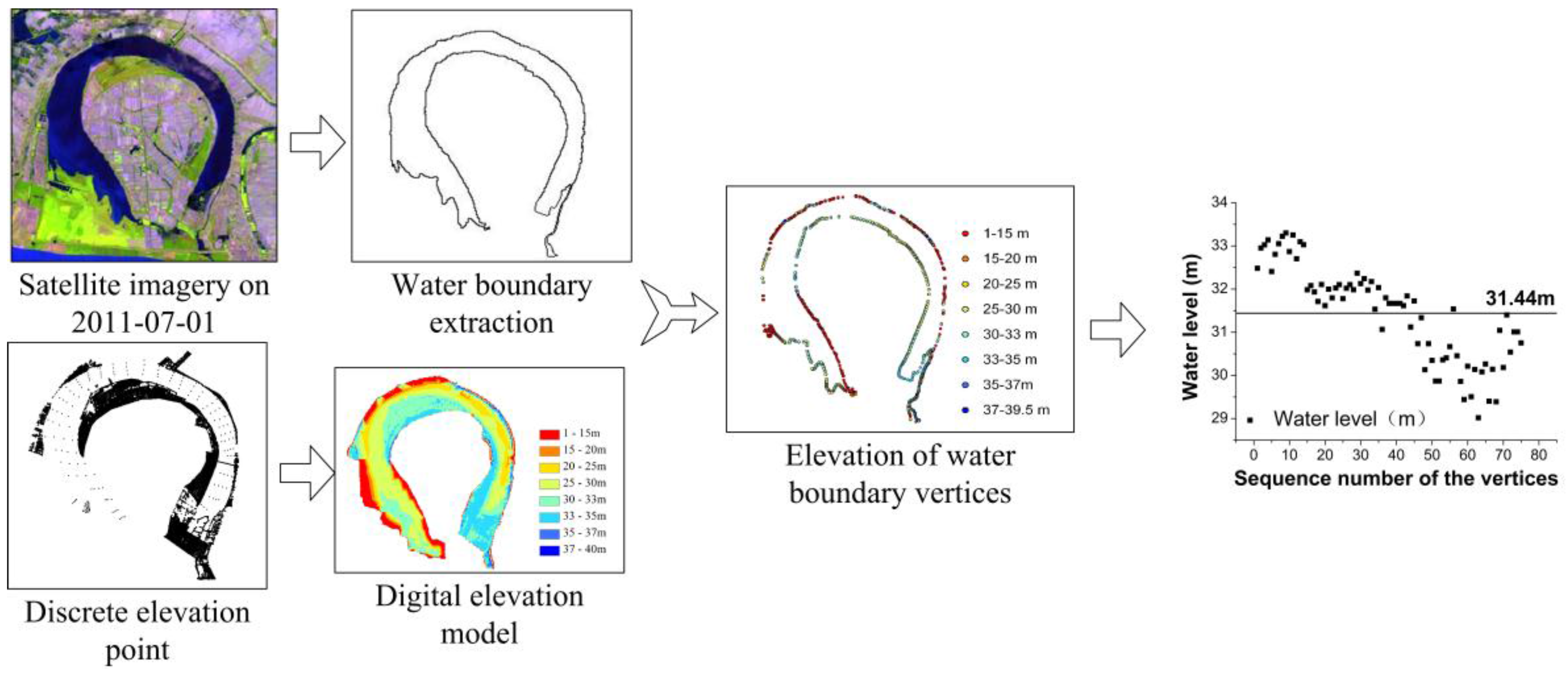
Figure 3.
Correlation analysis for the LRC method between the water surface area and the in situ water level.
Figure 3.
Correlation analysis for the LRC method between the water surface area and the in situ water level.

Figure 4.
Comparison of the gauged and estimated water levels.

Figure 5.
Temporal changes in water level and water surface areas during the flood and non-flood seasons of the Tian-e-Zhou oxbow lake from 1992–2015. (a,d) show the total water level and the water surface area variation during 1992–2015, respectively. (b,e) show the water level and the water surface area variation in the flood season (from June–September) during 1992–2015, respectively; and (c,f) show the water level and the water surface area variation in the non-flood season (from October–May) during 1992–2015, respectively. The black and grey lines in (a–c) show the water level extracted by using the WBET and LRC methods, respectively.
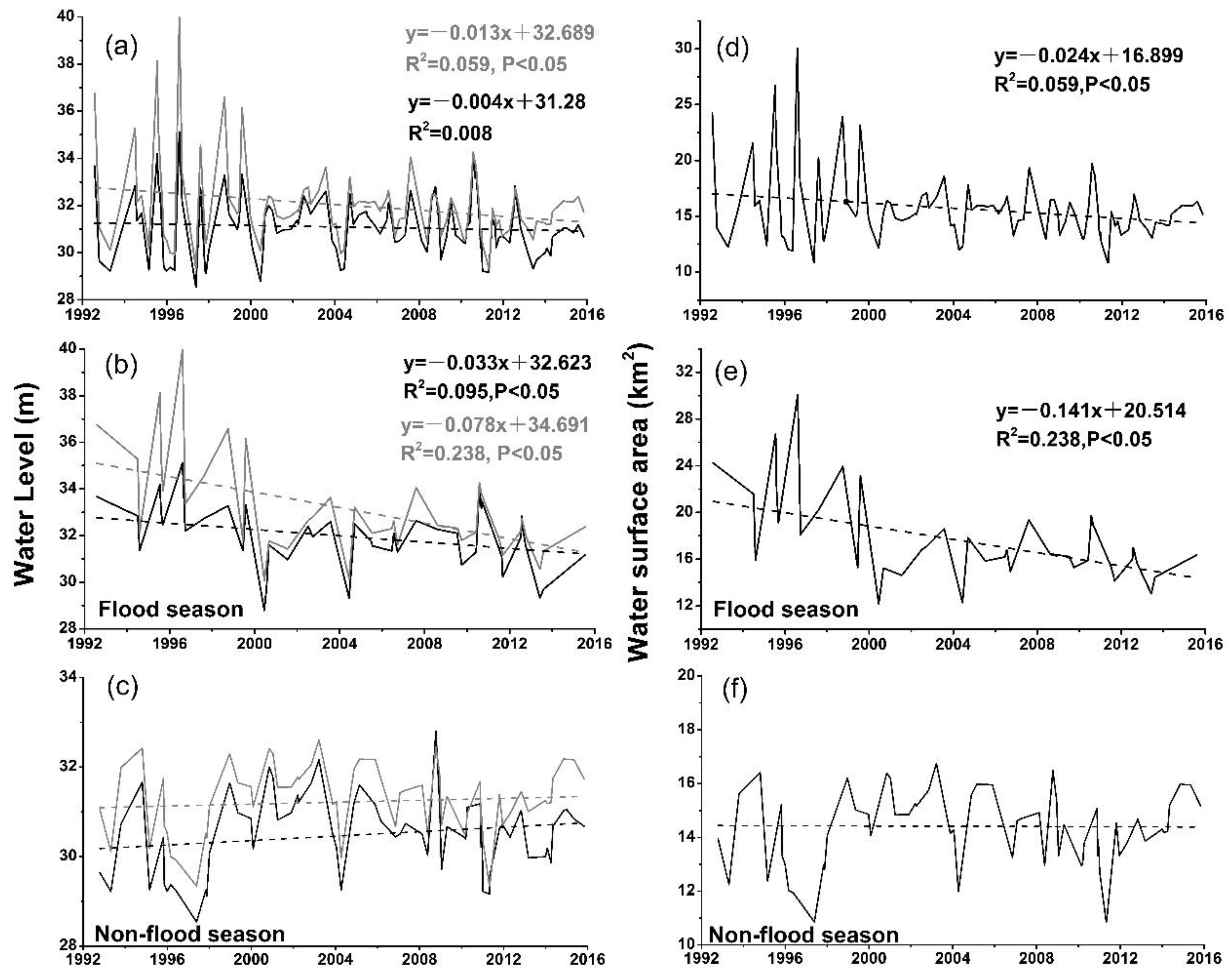
Figure 6.
Minimum and maximum water surface areas in the two observed periods: (a) 1992–1998; (b) 1999–2015.
Figure 6.
Minimum and maximum water surface areas in the two observed periods: (a) 1992–1998; (b) 1999–2015.
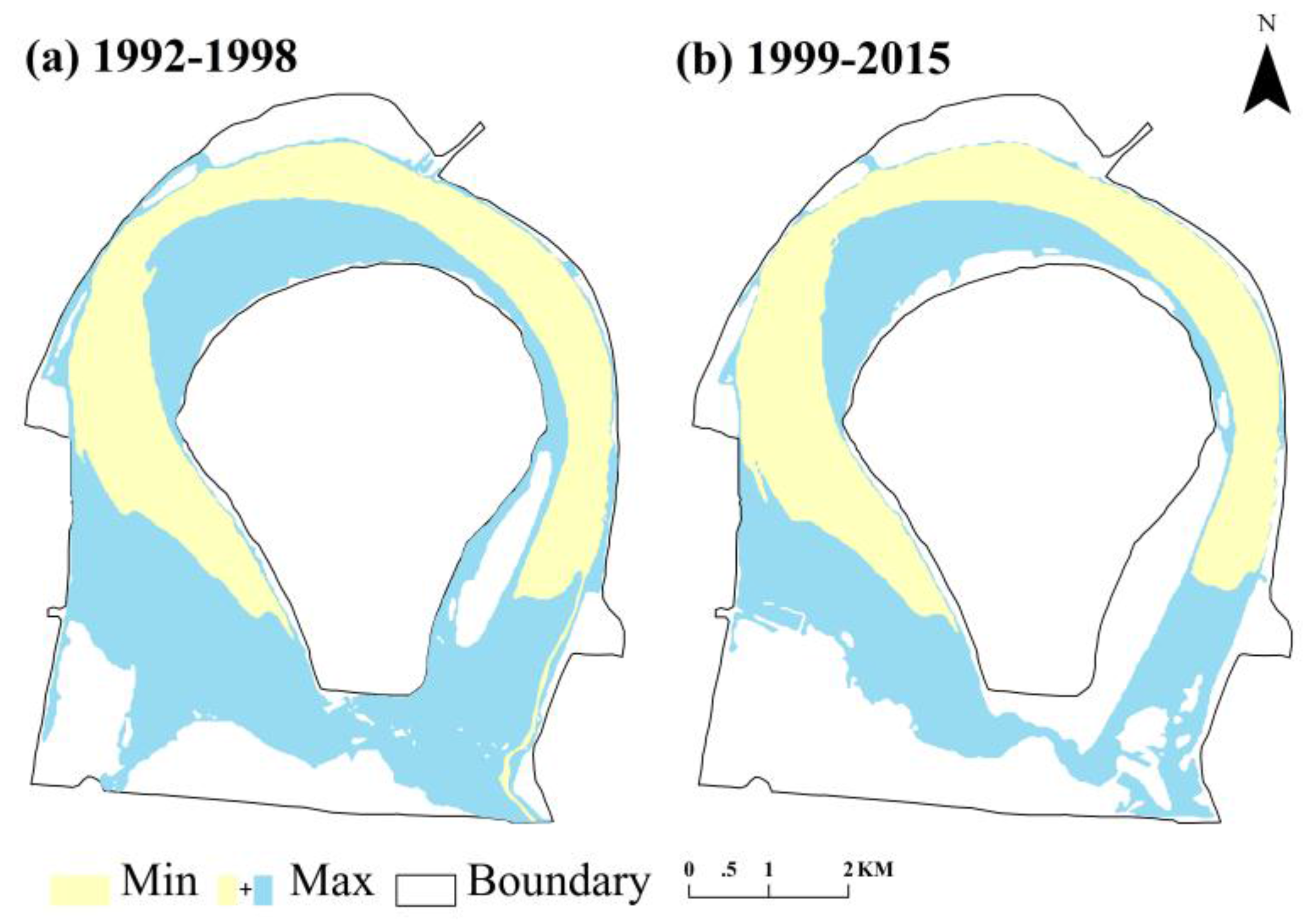
Figure 7.
The inundation frequencies in (a) 1992–1998 and (b) 1999–2015 in the oxbow lake.
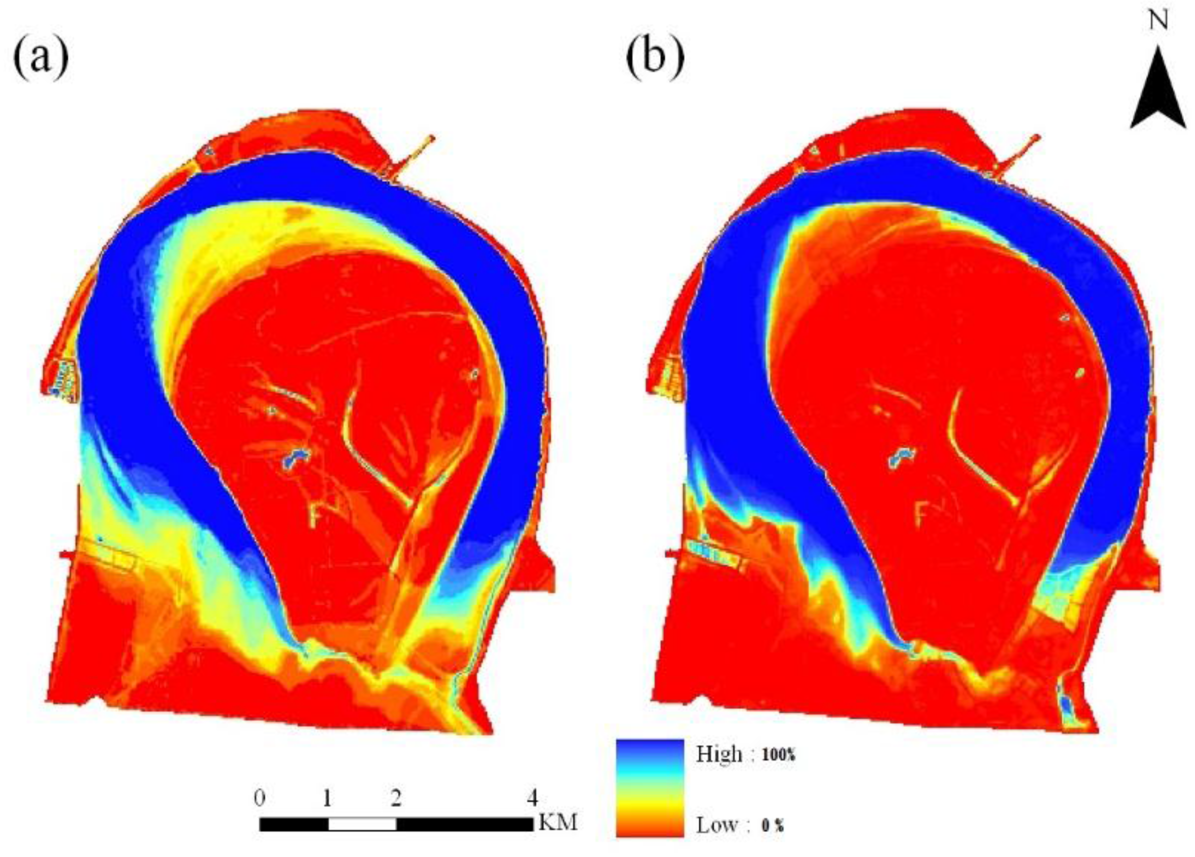
Figure 8.
The long-term precipitation and evapotranspiration in the Tian-e-Zhou oxbow lake between 1992 and 2015. The linear fitting line did not show an obvious synchronous change of the two climate factors.
Figure 8.
The long-term precipitation and evapotranspiration in the Tian-e-Zhou oxbow lake between 1992 and 2015. The linear fitting line did not show an obvious synchronous change of the two climate factors.

Table 1.
Fitting equations of the surface areas and in situ water levels in 2011 and 2012.
| Fitting Equations | R-Squared | RMSE (m) |
|---|---|---|
| y = 1.80538x − 42.1172 | 0.949 | 0.219 |
| y = −0.14654x2 + 10.9308x − 184.035 | 0.956 | 0.209 |
| y = −0.12991x3 + 12.00946x2 − 367.90225x + 3747.8398 | 0.959 | 0.215 |
Table 2.
Statistical characteristics of the two constructed models.
| Methods | RMSE (m) | MRE | R |
|---|---|---|---|
| WBET method | 0.386 | 0.9% | 0.975 |
| LRC method | 0.168 | 0.4% | 0.994 |
Table 3.
The average water level and water surface area changes before and after the construction of the Shatanzi Levee in 1998.
Table 3.
The average water level and water surface area changes before and after the construction of the Shatanzi Levee in 1998.
| Flood Season (June–September) | Non-Flood Season (October–May) | ||||||||
|---|---|---|---|---|---|---|---|---|---|
| 1992–1998 | 1999–2015 | 1992–1998 | 1999–2015 | ||||||
| WBET | LRC | WBET | LRC | WBET | LRC | WBET | LRC | ||
| Mean annual water level (m) | 33.06 | 35.51 | 31.59 | 32.3 | 29.65 | 30.72 | 30.77 | 31.47 | |
| Mean annual water surface area (km2) | 21.99 | 16.19 | 13.35 | 14.70 | |||||
© 2017 by the authors. Licensee MDPI, Basel, Switzerland. This article is an open access article distributed under the terms and conditions of the Creative Commons Attribution (CC BY) license (http://creativecommons.org/licenses/by/4.0/).
Share and Cite
MDPI and ACS Style
Yang, C.; Cai, X.; Wang, X. Remote Sensing of Hydrological Changes in Tian-e-Zhou Oxbow Lake, an Ungauged Area of the Yangtze River Basin. Remote Sens. 2018, 10, 27. https://doi.org/10.3390/rs10010027
AMA Style
Yang C, Cai X, Wang X. Remote Sensing of Hydrological Changes in Tian-e-Zhou Oxbow Lake, an Ungauged Area of the Yangtze River Basin. Remote Sensing. 2018; 10(1):27. https://doi.org/10.3390/rs10010027
Chicago/Turabian StyleYang, Chao, Xiaobin Cai, and Xuelei Wang. 2018. "Remote Sensing of Hydrological Changes in Tian-e-Zhou Oxbow Lake, an Ungauged Area of the Yangtze River Basin" Remote Sensing 10, no. 1: 27. https://doi.org/10.3390/rs10010027
Note that from the first issue of 2016, this journal uses article numbers instead of page numbers. See further details here.