
Are Crowdsourced Datasets Suitable for Specialized Routing Services? Case Study of OpenStreetMap for Routing of People with Limited Mobility


Abstract
:1. Introduction
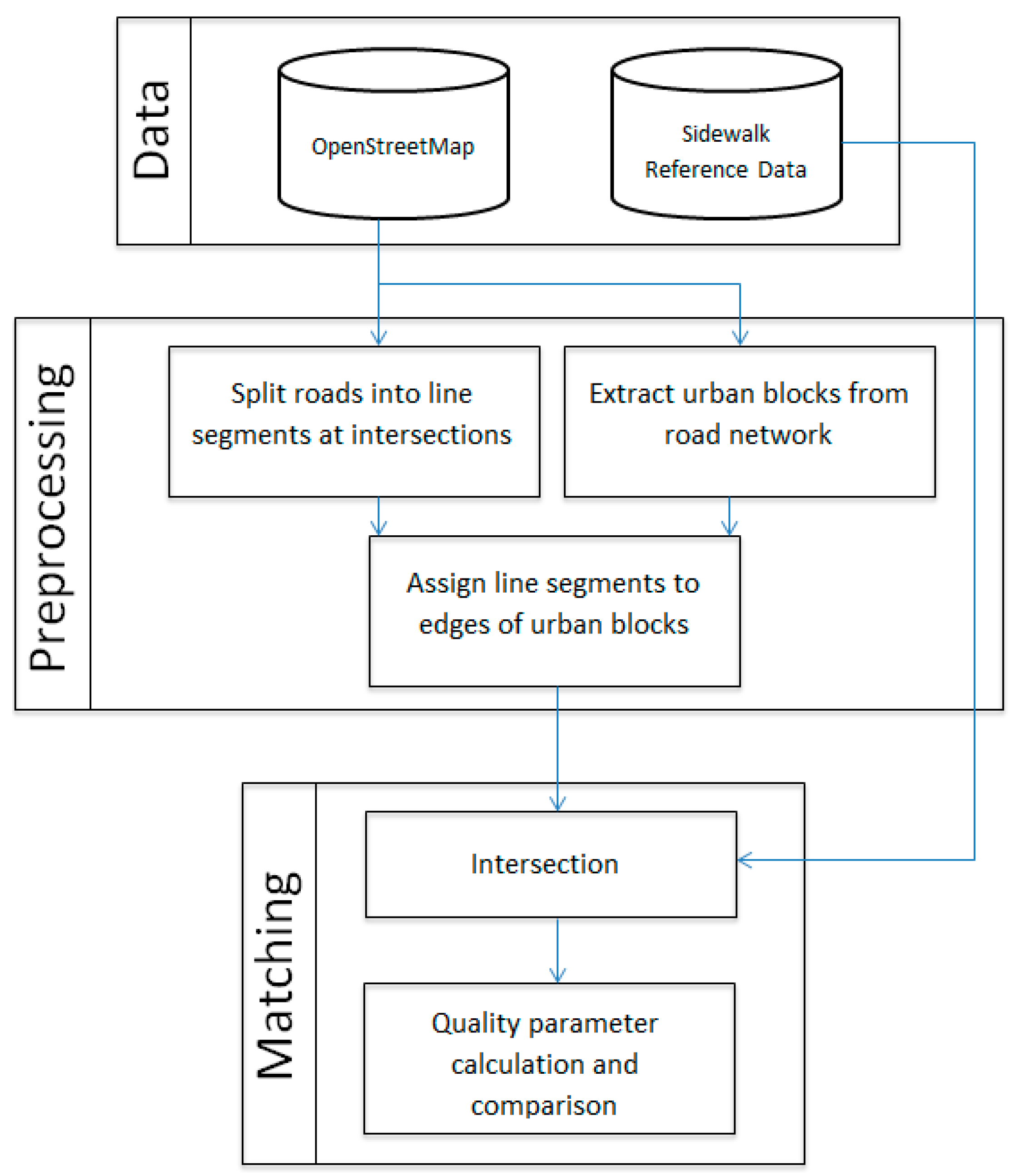
2. Methods
3. Results and Discussion
3.1. Extrinsic Quality Analysis
3.2. Intrinsic Quality Analysis
- Total number of highway features;
- Total number of residential highway features only (i.e., residential streets);
- Length of highway with major type including highways mapped as motorway, primary, secondary, tertiary and trunk;
- Length of highway with minor type including highways mapped as residential, track, and service;
- The total area covered by residential facilities;
- Total number of buildings;
- Total number of OSM users that have contributed data in a given area.
4. Conclusions and Future Work
Acknowledgments
Author Contributions
Conflicts of Interest
References
- Neis, P. Measuring the Reliability of Wheelchair User Route Planning based on Volunteered Geographic Information. Trans. GIS 2015, 19, 188–201. [Google Scholar] [CrossRef]
- Lee, J.H. Object Finder for the Visually Impaired (Bachelor of Information System Dissertation); Universiti Tunku Abdul Rahman: Kampar, Malaysia, 2013. [Google Scholar]
- Neis, P.; Zielstra, D. Generation of a tailored routing network for disabled people based on collaboratively collected geodata. Appl. Geogr. 2014, 47, 70–77. [Google Scholar] [CrossRef]
- Bakillah, M.; Lauer, J.; Liang, S.H.; Zipf, A.; Jokar Arsanjani, J.; Mobasheri, A.; Loos, L. Exploiting big VGI to improve routing and navigation services. In Big Data Techniques and Technologies in Geoinformatics; Karimi, H.A., Ed.; CRC Press: Boca Raton, FL, USA, 2014; pp. 177–192. [Google Scholar]
- Bakillah, M.; Mobasheri, A.; Liang, S.H.; Zipf, A. Towards an efficient routing web processing service through capturing real-time road conditions from big data. In Proceedings of the 2013 5th Computer Science and Electronic Engineering Conference, Colchester, UK, 17–18 September 2013; pp. 152–155. [Google Scholar]
- Rousell, A.; Hahmann, S.; Bakillah, M.; Mobasheri, A. Extraction of landmarks from OpenStreetMap for use in navigational instructions. In Proceedings of the AGILE Conference on Geographic Information Science, Lisbon, Portugal, 9–12 June 2015; Volume 83. [Google Scholar]
- Geisler, S.; Quix, C. Evaluation of real-time traffic applications based on data stream mining. In Data Mining for Geoinformatics; Springer: New York, NY, USA, 2014; pp. 83–103. [Google Scholar]
- Medjroubi, W.; Müller, U.P.; Scharf, M.; Matke, C.; Kleinhans, D. Open Data in Power Grid Modelling: New Approaches towards Transparent Grid Models. Energy Rep. 2017, 3, 14–21. [Google Scholar] [CrossRef]
- Bakillah, M.; Liang, S.; Mobasheri, A.; Jokar Arsanjani, J.; Zipf, A. Fine-resolution population mapping using OpenStreetMap points-of-interest. Int. J. Geogr. Inf. Sci. 2014, 28, 1940–1963. [Google Scholar] [CrossRef]
- Haklay, M.; Weber, P. Openstreetmap: User-generated street maps. IEEE Pervasive Comput. 2008, 7, 12–18. [Google Scholar] [CrossRef]
- Goodchild, M.F.; Li, L. Assuring the quality of volunteered geographic information. Spat. Stat. 2012, 1, 110–120. [Google Scholar] [CrossRef]
- Senaratne, H.; Mobasheri, A.; Ali, A.L.; Capineri, C.; Haklay, M. A review of volunteered geographic information quality assessment methods. Int. J. Geogr. Inf. Sci. 2017, 31, 139–167. [Google Scholar] [CrossRef]
- Haklay, M.; Ellul, C. Completeness in volunteered geographical information–the evolution of OpenStreetMap coverage in England (2008–2009). J. Spat. Inf. Sci. 2010. Available online: http://discovery.ucl.ac.uk/150397/ (accessed on 7 June 2017).
- Kounadi, O. Assessing the quality of OpenStreetMap data. In Msc Thesis in Geographical Information Science; University College of London Department of Civil, Environmental and Geomatic Engineering: London, UK, 2009. [Google Scholar]
- Haklay, M. How good is volunteered geographical information? A comparative study of OpenStreetMap and Ordnance Survey datasets. Environ. Plan. B Plan. Des. 2010, 37, 682–703. [Google Scholar] [CrossRef]
- Girres, J.F.; Touya, G. Quality assessment of the French OpenStreetMap dataset. Trans. GIS 2010, 14, 435–459. [Google Scholar] [CrossRef]
- Barron, C.; Neis, P.; Zipf, A. A comprehensive framework for intrinsic OpenStreetMap quality analysis. Trans. GIS 2014, 18, 877–895. [Google Scholar] [CrossRef]
- Castro Degrossi, L.; Porto de Albuquerque, J.; Restrepo-Estrada, C.E.; Mobasheri, A.; Zipf, A. Exploring the geographical context for quality assessment of VGI in flood management domain. In Proceedings of the 23rd Americas Conference on Information Systems, Boston, MA, USA, 10–12 August 2017. [Google Scholar]
- Ludwig, I.; Voss, A.; Krause-Traudes, M. A Comparison of the Street Networks of Navteq and OSM in Germany. In Advancing Geoinformation Science for a Changing World; Springer: Berlin/Heidelberg, Germany, 2011; pp. 65–84. [Google Scholar]
- Koukoletsos, T.; Haklay, M.; Ellul, C. Assessing data completeness of VGI through an automated matching procedure for linear data. Trans. GIS 2012, 16, 477–498. [Google Scholar] [CrossRef]
- Zielstra, D.; Zipf, A. A comparative study of proprietary geodata and volunteered geographic information for Germany. In Proceedings of the 13th AGILE International Conference on Geographic Information Science, Guimarães, Portugal, 11–14 May 2010; Volume 2010. [Google Scholar]
- Neis, P.; Zielstra, D.; Zipf, A. The street network evolution of crowdsourced maps: OpenStreetMap in Germany 2007–2011. Future Internet 2011, 4, 1–21. [Google Scholar] [CrossRef]
- Fan, H.; Zipf, A.; Fu, Q.; Neis, P. Quality assessment for building footprints data on OpenStreetMap. Int. J. Geogr. Inf. Sci. 2014, 28, 700–719. [Google Scholar] [CrossRef]
- Hochmair, H.H.; Zielstra, D.; Neis, P. Assessing the completeness of bicycle trails and designated lane features in OpenStreetMap for the United States and Europe. In Proceedings of the Transportation Research Board 92nd Annual Meeting, Washington, DC, USA, 13–17 January 2013; pp. 13–17. [Google Scholar]
- Jokar Arsanjani, J.; Mooney, P.; Zipf, A.; Schauss, A. Quality assessment of the contributed land use information from OpenStreetMap versus authoritative datasets. In OpenStreetMap in GIScience; Jokar Arsanjani, J., Zipf, A., Mooney, P., Helbich, M., Eds.; Lecture Notes in Geoinformation and Cartography; Springer International Publishing: Cham, Switzerland, 2015; pp. 37–58. [Google Scholar]
- Ding, C.; Wald, M.; Wills, G. A survey of open accessibility data. In Proceedings of the 11th Web for All Conference ACM, Seoul, Korea, 7 April 2014; p. 37. [Google Scholar]
- CAP4Access European FP7 Project. Available online: http://www.geog.uni-heidelberg.de/gis/cap4access_en.html (accessed on 7 June 2017).
- Kammoun, S.; Dramas, F.; Oriolaand, B.; Jouffrais, C. Route selection algorithm for blind pedestrian. In Proceedings of the 2010 International Conference on Control Automation and Systems, Gyeonggi-do, Korea, 27–30 October 2010; pp. 2223–2228. [Google Scholar]
- Kasemsuppakorn, P.; Karimi, H.A. Personalised routing for wheelchair navigation. J. Locat. Based Serv. 2009, 3, 24–54. [Google Scholar] [CrossRef]
- Sobek, A.D.; Miller, H.J. U-Access: A web-based system for routing pedestrians of differing abilities. J. Geogr. Syst. 2006, 8, 269–287. [Google Scholar] [CrossRef]
- Mirri, S.; Prandi, C.; Salomoni, P.; Callegati, F.; Campi, A. On combining crowdsourcing, sensing and open data for an accessible smart city. In Proceedings of the 2014 Eighth International Conference on Next Generation Mobile Apps, Services and Technologies, Oxford, UK, 10–12 September 2014; pp. 294–299. [Google Scholar]
- Zipf, A.; Mobasheri, A.; Rousell, A.; Hahmann, S. Crowdsourcing for individual needs—The case of routing and navigation for mobility-impaired persons. In European Handbook of Crowdsourced Geographic Information; Capineri, C., Haklay, M., Huang, H., Antoniou, V., Kettunen, J., Ostermann, F., Puves, R., Eds.; Ubiquity Press: London, UK, 2016; pp. 325–337. [Google Scholar]
- Rahaman, M.S.; Mei, Y.; Hamilton, M.; Salim, F.D. CAPRA: A contour-based accessible path routing algorithm. Inf. Sci. 2017, 385, 157–173. [Google Scholar] [CrossRef]
- Walter, V.; Kada, M.; Chen, H. Shortest path analyses in raster maps for pedestrian navigation in location based systems. In International Symposium on “Geospatial Databases for Sustainable Development”; ISPRS Technical Commission IV (on CDROM): Goa, India, 2006. [Google Scholar]
- Han, C.S.; Law, K.H.; Latombe, J.C.; Kunz, J.C. A performance-based approach to wheelchair accessible route analysis. Adv. Eng. Inform. 2002, 16, 53–71. [Google Scholar] [CrossRef]
- Deutsches Institut für Normung (DIN). DIN 18024-1. Available online: http://nullbarriere.de/din18024-1.htm (accessed on 7 June 2017).
- Beale, L.; Field, K.; Briggs, D.; Picton, P.; Matthews, H. Mapping for wheelchair users: Route navigation in urban spaces. Cartogr. J. 2006, 43, 68–81. [Google Scholar] [CrossRef]
- Ding, D.; Parmanto, B.; Karimi, H.A.; Roongpiboonsopit, D.; Pramana, G.; Conahan, T.; Kasemsuppakorn, P. Design considerations for a personalized wheelchair navigation system. In Proceedings of the EMBS 2007 29th Annual International Conference of the IEEE Engineering in Medicine and Biology Society, Lyon, France, 22–26 August 2007; pp. 4790–4793. [Google Scholar]
- Matthews, H.; Beale, L.; Picton, P.; Briggs, D. Modelling Access with GIS in Urban Systems (MAGUS): Capturing the experiences of wheelchair users. Area 2003, 35, 34–45. [Google Scholar] [CrossRef]
- Canavosio-Zuzelski, R.; Agouris, P.; Doucette, P. A photogrammetric approach for assessing positional accuracy of OpenStreetMap© roads. ISPRS Int. J. Geo-Inf. 2013, 2, 276–301. [Google Scholar] [CrossRef]
- Codescu, M.; Horsinka, G.; Kutz, O.; Mossakowski, T.; Rau, R. Osmonto-an ontology of openstreetmap tags. In Proceedings of the State of the Map Europe (SOTM-EU) Conference, Vienna, Austria, 15–17 July 2011. [Google Scholar]
- Mooney, P.; Corcoran, P. The annotation process in OpenStreetMap. Trans. GIS 2012, 16, 561–579. [Google Scholar] [CrossRef]
- Ali, A.L.; Sirilertworakul, N.; Zipf, A.; Mobasheri, A. Guided Classification System for Conceptual Overlapping Classes in OpenStreetMap. ISPRS Int. J. Geo-Inf. 2016, 5, 87. [Google Scholar] [CrossRef]
- Da Silva, A.C.; Wu, S.T. Consistent handling of linear features in polyline simplification. In Advances in Geoinformatics; Springer: Berlin/Heidelberg, Germany, 2007; pp. 1–17. [Google Scholar]
- Corcoran, P.; Mooney, P.; Winstanley, A. Topological consistent generalization of OpenStreetMap. In Proceedings of the GISRUK 2010: GIS Research UK 18 Annual Conference, London, UK, 14–16 April 2010. [Google Scholar]
- Hashemi, P.; Abbaspour, R.A. Assessment of logical consistency in openstreetmap based on the spatial similarity concept. In OpenStreetMap in GIScience; Arsanjani, J.J., Zipf, A., Mooney, P., Helbich, M., Eds.; Springer Lecture Notes in Geoinformation and Cartography; Springer: Cham, Switzerland, 2015; pp. 19–36. [Google Scholar]
- International Organization for Standardization. Geographic Information—Data Quality; ISO 19157; ISO: Geneva, Switzerland, 2013. [Google Scholar]
- Ciepłuch, B.; Mooney, P.; Jacob, R.; Zheng, J.; Winstanely, A. Assessing the quality of open spatial data for mobile location-based services research and applications. Arch. Fotogram. Kartogr. Teledetekcji 2011, 22, 105–116. [Google Scholar]
- Tenney, M. Quality Evaluations on Canadian OpenStreetMap Data. Available online: http://rose.geog.mcgill.ca/ski/system/files/fm/2014/tenney.pdf (accessed on 7 June 2017).
- Ballatore, A.; Bertolotto, M.; Wilson, D.C. Geographic knowledge extraction and semantic similarity in OpenStreetMap. Knowl. Inf. Syst. 2013, 37, 61–81. [Google Scholar] [CrossRef]
- Janowicz, K.; Raubal, M.; Schwering, A.; Kuhn, W. Semantic similarity measurement and geospatial applications. Trans. GIS 2008, 12, 651–659. [Google Scholar] [CrossRef]
- Kardos, J.D.; Moore, A.; Benwell, G.L. Visualising uncertainty in spatially-referenced attribute data using hierarchical spatial data structures. In Proceedings of the 7th International Conference on GeoComputation, Southampton, UK, 8–10 September 2003. [Google Scholar]
- Ali, A.L.; Schmid, F. Data quality assurance for Volunteered Geographic Information. In Geographic Information Science; Springer: Vienna, Austria, 2014; pp. 126–141. [Google Scholar]
- Neis, P.; Zielstra, D.; Zipf, A. Comparison of volunteered geographic information data contributions and community development for selected world regions. Future Internet 2013, 5, 282–300. [Google Scholar] [CrossRef]
- Jokar Arsanjani, J.; Bakillah, M. Understanding the potential relationship between the socio-economic variables and contributions to OpenStreetMap. Int. J. Digit. Earth 2015, 8, 861–876. [Google Scholar] [CrossRef]
- Mashadi, A.; Quattrone, G.; Capra, L. The impact of society on volunteered geographic information: The case of OpenStreetMap. In OpenStreetMap in GIScience; Springer International Publishing: Cham, Switzerland, 2015; pp. 125–141. [Google Scholar]
- Quinn, S. Using small cities to understand the crowd behind OpenStreetMap. GeoJournal 2015, 1–19. [Google Scholar] [CrossRef]
- Quattrone, G.; Capra, L.; De Meo, P. There’s no such thing as the perfect map: Quantifying bias in spatial crowd-sourcing datasets. In Proceedings of the 18th ACM Conference on Computer Supported Cooperative Work & Social Computing, Vancouver, BC, Canada, 14–18 March 2015; pp. 1021–1032. [Google Scholar]
- Fan, H.; Yang, B.; Zipf, A.; Rousell, A. A polygon-based approach for matching OpenStreetMap road networks with regional transit authority data. Int. J. Geogr. Inf. Sci. 2016, 30, 1–17. [Google Scholar] [CrossRef]
- OSM2PGSQL Tool. Available online: https://github.com/openstreetmap/osm2pgsql (accessed on 7 June 2017).
- Jokar Arsanjani, J.; Helbich, M.; Bakillah, M.; Loos, L. The emergence and evolution of OpenStreetMap: A cellular automata approach. Int. J. Digit. Earth 2015, 8, 76–90. [Google Scholar] [CrossRef]
- Arsanjani, J.J.; Barron, C.; Bakillah, M.; Helbich, M. Assessing the Quality of OpenStreetMap Contributors together with their Contributions. In Proceedings of the AGILE Conference, Leuven, Belgium, 14–17 May 2013. [Google Scholar]
- Neis, P.; Zipf, A. Analyzing the contributor activity of a volunteered geographic information project—The case of OpenStreetMap. ISPRS Int. J. Geo-Inf. 2012, 1, 146–165. [Google Scholar] [CrossRef]
- Roick, O.; Loos, L.; Zipf, A. A Technical Framework for Visualizing Spatio-temporal Quality Metrics of Volunteered Geographic Information. In Proceedings of the GEOINFORMATIK 2012—Mobility and Environment, Braunschweig, Germany, 28–30 March 2012. [Google Scholar]
- OSMatrix Tool, Owned by GIScience Research Group, Heidelberg University, Heidelberg, Germany. Available online: http://osmatrix.uni-hd.de/ (accessed on 7 June 2017).
- Bakillah, M.; Mobasheri, A.; Rousell, A.; Hahmann, S.; Jokar, J.; Liang, S.H. Toward a collective tagging Android application for gathering accessibility-related geospatial data in European cities. In Proceedings of the 18th AGILE International Conference on Geographic Information Science, Lisbon, Portugal, 9–12 June 2015. [Google Scholar]


| Data | Total Number of Sidewalks | Percentage of Sidewalks (Total) | Total Length of Sidewalks (km) | Percentage of Sidewalks Length |
|---|---|---|---|---|
| OpenStreetMap | 1443 | 22.5% | 86.6 | 17.6% |
| Reference Data | 6398 | 100% | 492 | 100% |
| City | Total Number of Highways | Number of Highways with Sidewalk Tag | Percentage of Highways with Sidewalk Info. |
|---|---|---|---|
| Berlin | 101,189 | 8320 | 8.2% |
| Munich | 69,143 | 846 | 1.2 % |
| Hamburg | 81,812 | 1715 | 2.1% |
| Freiburg | 18,829 | 2225 | 11.8% |
| Heidelberg | 10,178 | 1443 | 14.1% |
| Parameter | OSM Tag | Scale |
|---|---|---|
| Type of street | highway = living_street | |
| Sidewalk | sidewalk = left|right|yes|no|both | |
| Footway | footway = left|right|yes|no|both | |
| Sidewalk, width | sidewalk(:left|:right):width = * | [m] |
| Sidewalk, surface | sidewalk(:left|:right):surface = paved | |
| Sidewalk, smoothness | sidewalk(:left|:right):smoothness = good | |
| Sidewalk, slope/incline | sidewalk(:left|:right):incline = * | [%] |
| Sidewalk, curb | sidewalk(:left|:right):sloped_curb(:start|:end) = * | [m] |
| Steps | step_count = * | |
| Step height | step:height = * | |
| Ramp | highway = steps | |
| ramp = yes | ||
| ramp:wheelchair = yes | ||
| ramp:stroller = yes |
| City | Width | Surface | Smoothness | Incline | Curb | Step Count | Step Height | Ramp |
|---|---|---|---|---|---|---|---|---|
| Berlin | 452 | 2632 | 952 | 25 | 0 | 1 | 0 | 0 |
| Munich | 17 | 195 | 59 | 1 | 0 | 0 | 0 | 0 |
| Hamburg | 76 | 345 | 2 | 3 | 0 | 4 | 0 | 0 |
| Freiburg | 9 | 459 | 0 | 6 | 0 | 0 | 0 | 0 |
| Heidelberg | 8 | 113 | 126 | 6 | 0 | 0 | 0 | 0 |
| % of Coverage *: | ||||||||
| Berlin | 5.4% | 31.6% | 11.4% | 0.3% | 0 | 0.01% | 0 | 0 |
| Munich | 2.0% | 23% | 6.9% | 0.11% | 0 | 0 | 0 | 0 |
| Hamburg | 4.4% | 20.1% | 0.1% | 0.17% | 0 | 0.2% | 0 | 0 |
| Freiburg | 0.4% | 20.6% | 0 | 0.26% | 0 | 0 | 0 | 0 |
| Heidelberg | 0.9% | 13.1% | 14.7% | 0.7% | 0 | 0 | 0 | 0 |
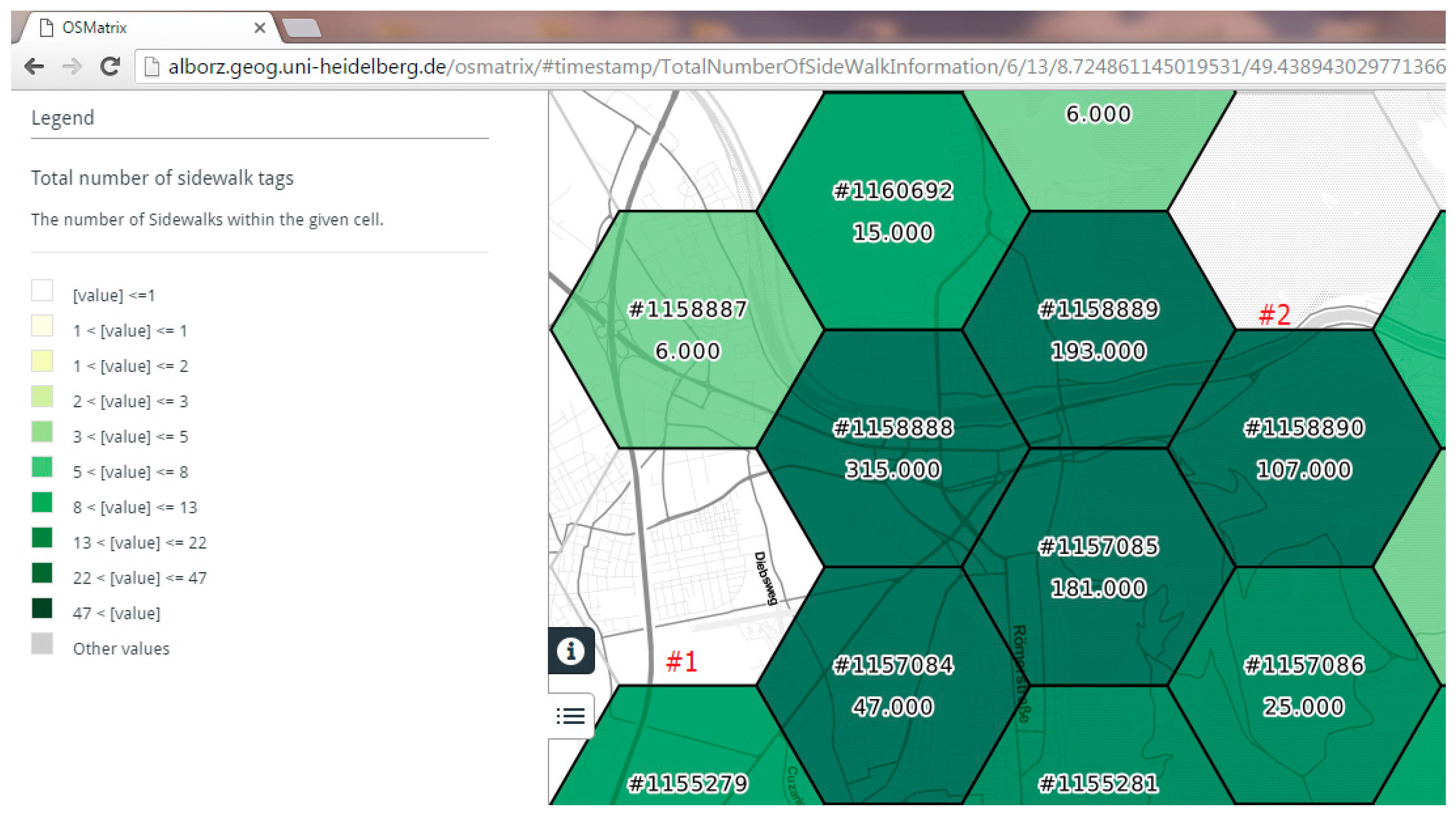
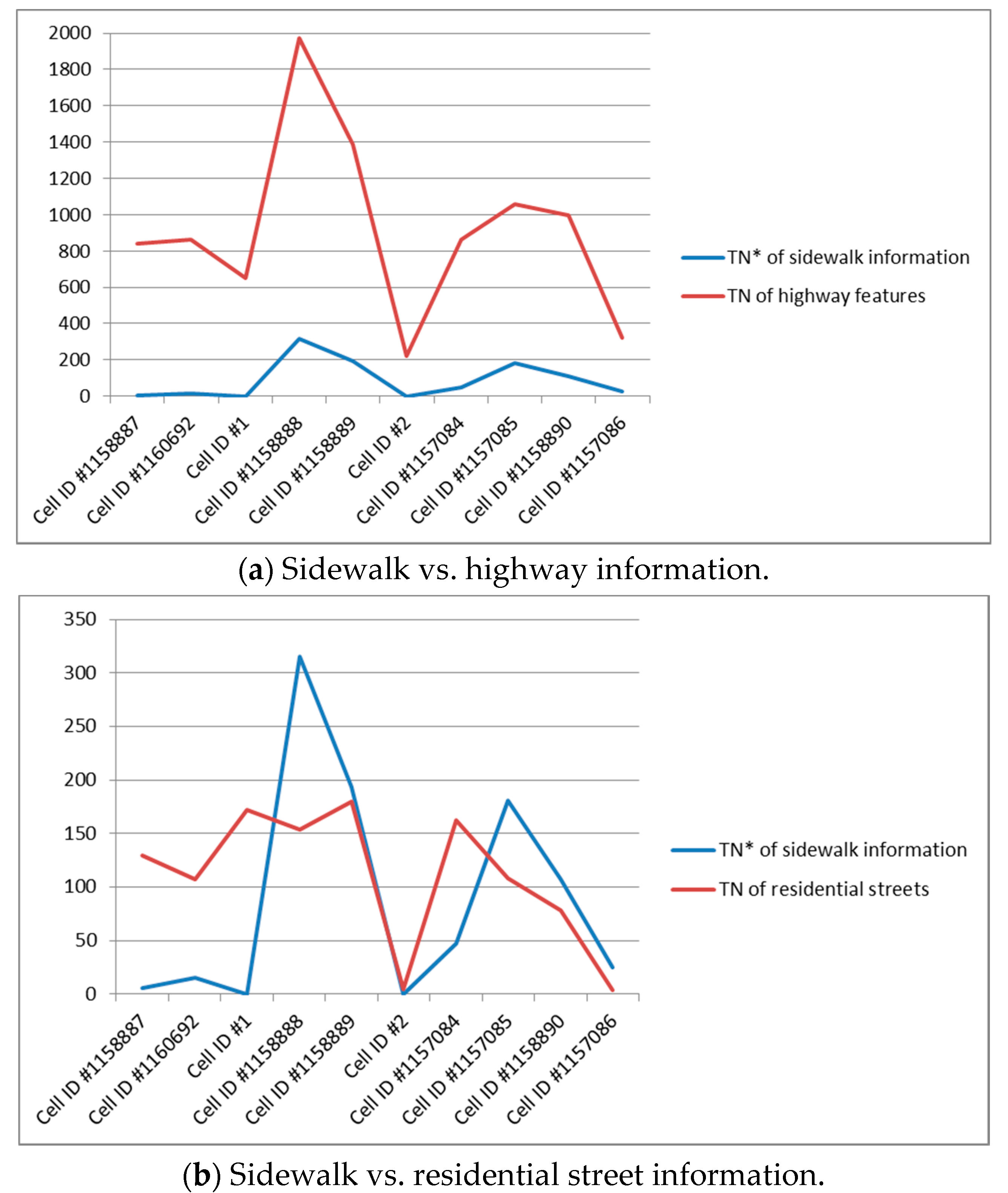
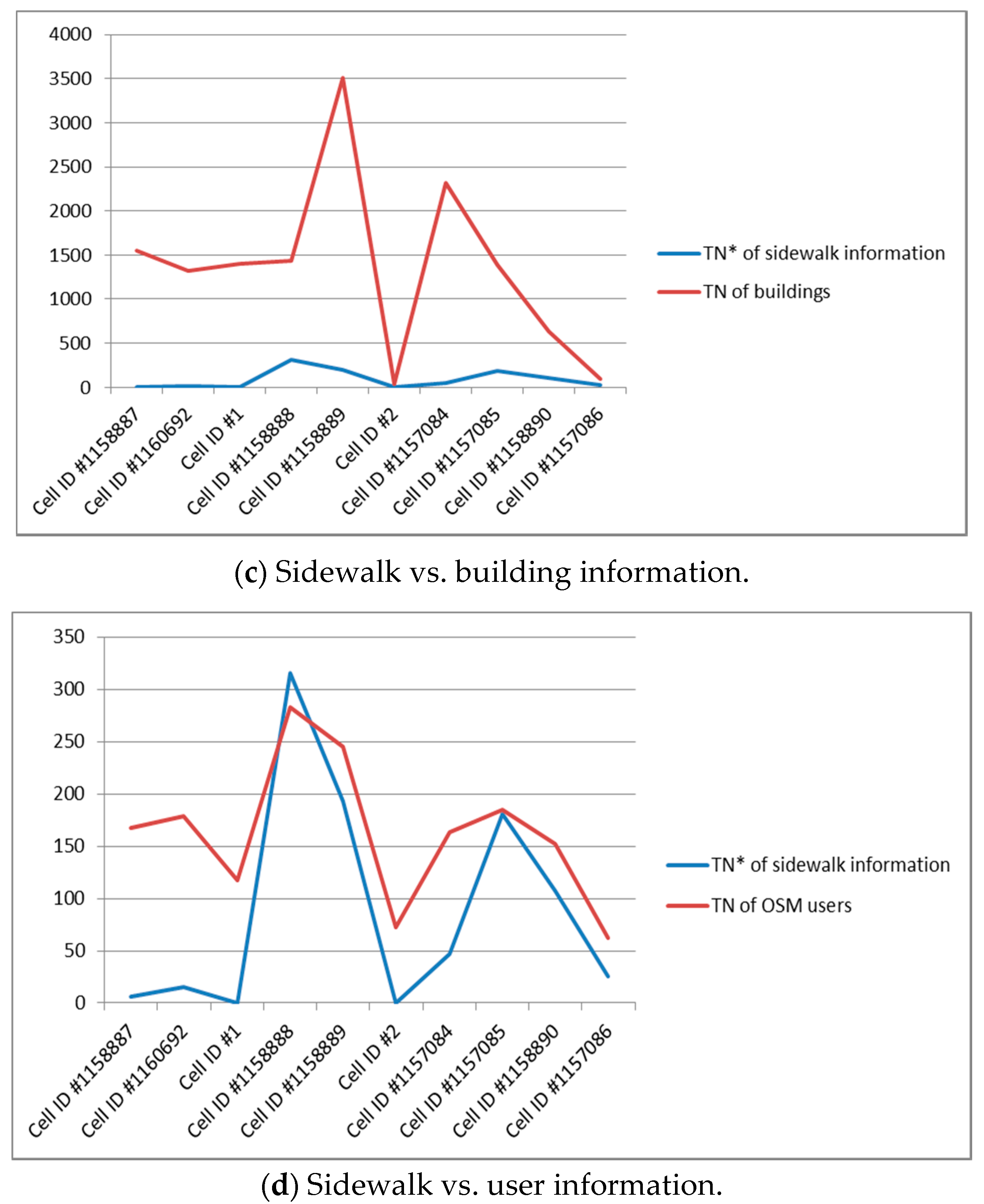
| Indicators | TN * of Sidewalk Information | TN of Highway Features | TN of Residential Streets | Length of Highway (Major)-km | Length of Highway (Minor)-km | TA ^ of Residential Facilities-m2 | TN of Buildings | TN of OSM Users |
|---|---|---|---|---|---|---|---|---|
| Cell ID #1158887 | 6 | 842 | 129 | 40,934 | 81,513 | 2,287,254 | 1544 | 167 |
| Cell ID #1160692 | 15 | 863 | 107 | 6479 | 80,900 | 2,420,076 | 1321 | 179 |
| Cell ID #1 | 0 | 651 | 172 | 22,559 | 89,624 | 4,053,674 | 1402 | 117 |
| Cell ID #1158888 | 315 | 1972 | 154 | 39,578 | 82,649 | 2,660,671 | 1440 | 283 |
| Cell ID #1158889 | 193 | 1387 | 180 | 16,317 | 86,489 | 5,459,871 | 3506 | 245 |
| Cell ID #2 | 0 | 223 | 5 | 2163 | 61,188 | 208,298 | 34 | 72 |
| Cell ID #1157084 | 47 | 865 | 162 | 20,179 | 84,250 | 3,663,269 | 2312 | 163 |
| Cell ID #1157085 | 181 | 1057 | 108 | 20,242 | 65,002 | 3,373,008 | 1385 | 185 |
| Cell ID #1158890 | 107 | 995 | 78 | 12,257 | 61,310 | 1,608,136 | 628 | 152 |
| Cell ID #1157086 | 25 | 319 | 4 | 12,624 | 54,871 | 55,584 | 99 | 62 |
© 2017 by the authors. Licensee MDPI, Basel, Switzerland. This article is an open access article distributed under the terms and conditions of the Creative Commons Attribution (CC BY) license (http://creativecommons.org/licenses/by/4.0/).
Share and Cite
Mobasheri, A.; Sun, Y.; Loos, L.; Ali, A.L. Are Crowdsourced Datasets Suitable for Specialized Routing Services? Case Study of OpenStreetMap for Routing of People with Limited Mobility. Sustainability 2017, 9, 997. https://doi.org/10.3390/su9060997
Mobasheri A, Sun Y, Loos L, Ali AL. Are Crowdsourced Datasets Suitable for Specialized Routing Services? Case Study of OpenStreetMap for Routing of People with Limited Mobility. Sustainability. 2017; 9(6):997. https://doi.org/10.3390/su9060997
Chicago/Turabian StyleMobasheri, Amin, Yeran Sun, Lukas Loos, and Ahmed Loai Ali. 2017. "Are Crowdsourced Datasets Suitable for Specialized Routing Services? Case Study of OpenStreetMap for Routing of People with Limited Mobility" Sustainability 9, no. 6: 997. https://doi.org/10.3390/su9060997
APA StyleMobasheri, A., Sun, Y., Loos, L., & Ali, A. L. (2017). Are Crowdsourced Datasets Suitable for Specialized Routing Services? Case Study of OpenStreetMap for Routing of People with Limited Mobility. Sustainability, 9(6), 997. https://doi.org/10.3390/su9060997