
The Spatial Differentiation of the Suitability of Ice-Snow Tourist Destinations Based on a Comprehensive Evaluation Model in China


Abstract
:1. Introduction
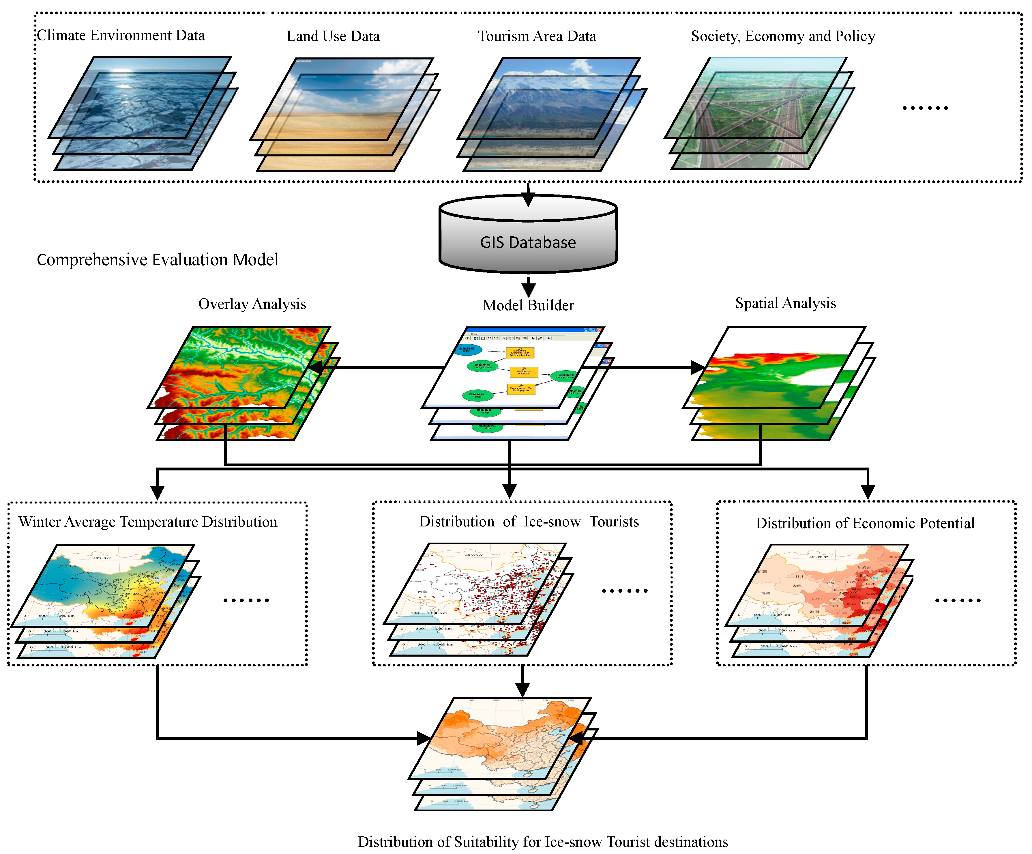
2. Data and Model
2.1. Data
2.2. Suitability Model
3. Research Results and Analysis
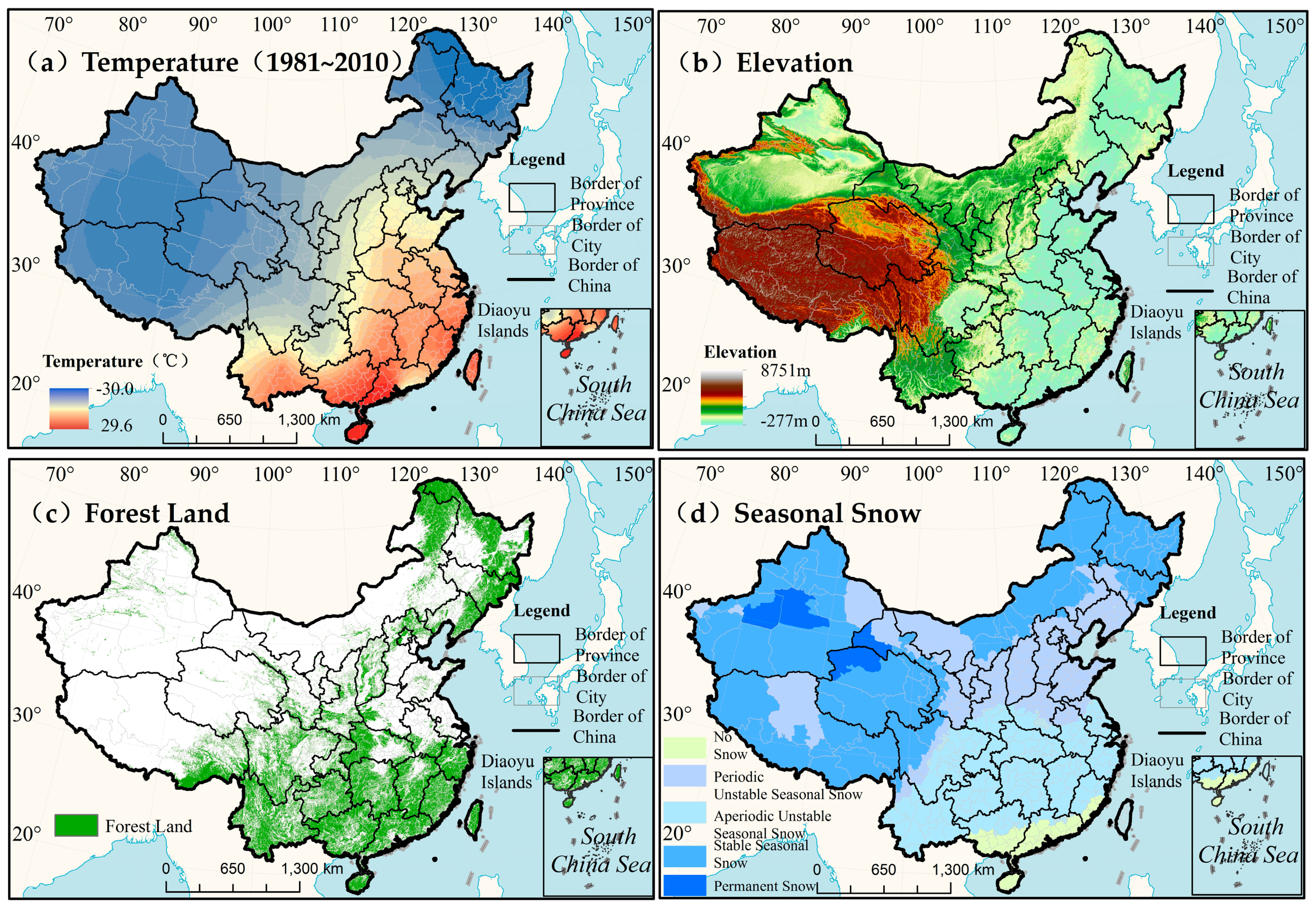
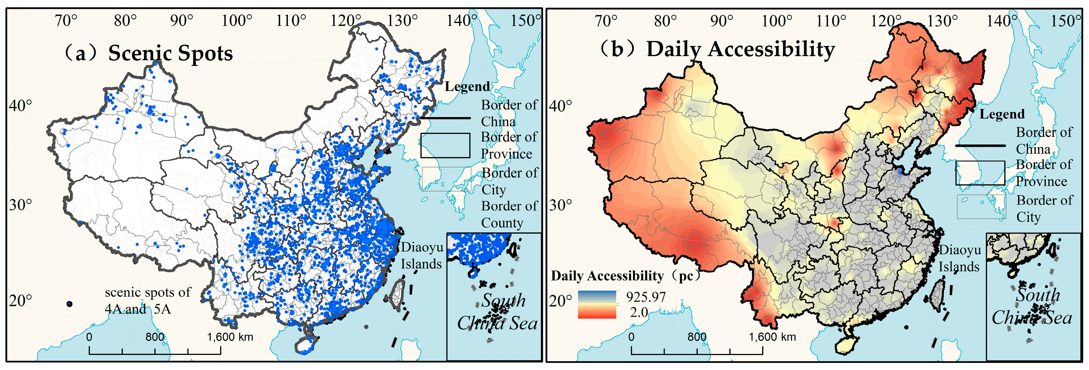
3.1. Environmental Resource Index
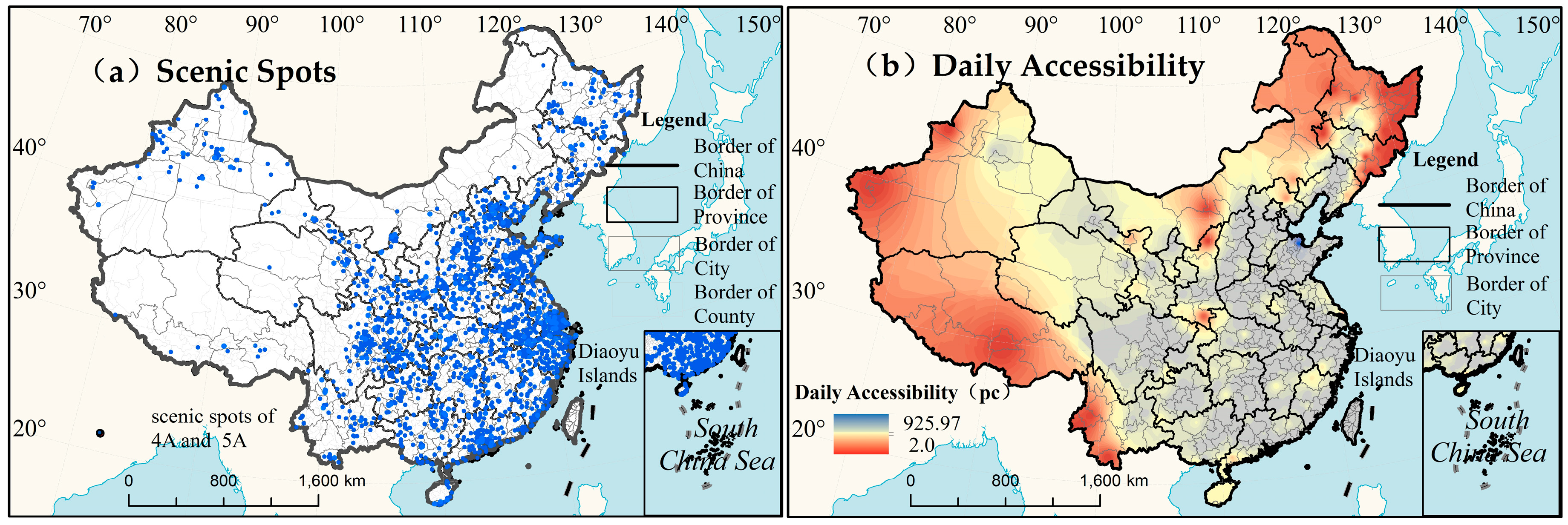
3.2. Development Status Index
3.3. Industry Potential Index
4. Results and Discussion
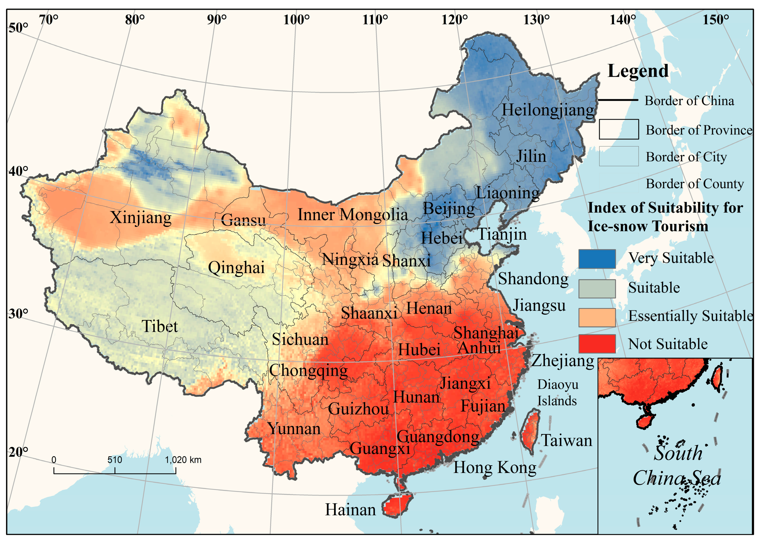
4.1. Results
4.2. Conclusions
- (1)
- Taking into account the three factors, which are dependent on the city + tourist area development model, which considers the difference between the dependence on ice and snow resources and the status of urban development considerations, China’s ice and snow tourism destination is better suited to the Heilongjiang region in Jilin central city, Xinjiang and some cities in Hebei Province; Harbin (longitude 125°42’–130°10’, latitude 44°04’–46°40’), Changchun (longitude 124°18’–127°02’ , latitude 43°05’–45°15’), Changji Hui Autonomous Prefecture (east longitude 86°24’–87°37’, latitude 43°06’–45°20’) and Zhangjiakou (longitude 113°50’–116°30’, latitude 39°30’–42°10’). China's ice and snow resources are limited to the northeastern region of ice and snow tourism development in the scale and impact of a leading position. The resources and environmental advantages of an outstanding ice and snow tourism industry development is substantial.
- (2)
- The snow and ice resources and the development of an urban development status has improved with the potential for the development of cities in the western region of China. Tibet (longitude 78°25’–99°06’, latitude 26°44’–36°32’ ), Qinghai (east longitude 89°41’–103°07’, latitude 31°41’–39°07’) and other places have stable ice and snow resources but a small scale and underdeveloped economy. The Inner Mongolia 97°21’–126°07’, latitude 37°41’–53°38’) area’s mountains and rivers are rich in forest resources, have unique winter snow and ice resources, and have a long period of snowfall; this city can easily implement ice and snow tourism projects.
- (3)
- Northern China does not have sufficient snow and ice resources. As the center of the social and economic advantages of its ice and snow tourism industry, the city of Beijing has to rely on market demand, traffic location advantages and artificial development technology, which occupy a relatively small part of the snow and ice market share. Tourism development and the potential of the large southeast and coastal cities, which do not have snow and ice tourism resources and are not suitable for outdoor snow and ice tourism projects, are lacking. Individual large cities have to consider the cost and effectiveness of the construction of urban artificial ice and snow and snow and ice leisure travel.
4.3. Discussion
Acknowledgments
Author Contributions
Conflicts of Interest
References
- Fischer, A.; Olefs, M.; Abermann, J. Glaciers, snow and ski tourism in Austria's changing climate. Ann. Glaciol. 2011, 52, 89–96. [Google Scholar] [CrossRef]
- May, V. Environmental implications of the 1992 Winter Olympic Games. Tour. Manag. 1995, 16, 269–275. [Google Scholar] [CrossRef]
- Sharpley, R. Snow Business: A Study of the International Ski Industry. Tour. Manag. 2002, 23, 419–425. [Google Scholar] [CrossRef]
- Dewar, K.; Meyer, D.; Wen, M.L. Harbin, lanterns of ice, sculptures of snow. Tour. Manag. 2001, 22, 523–532. [Google Scholar] [CrossRef]
- Scott, D.; McBoyle, G.; Minogue, A.; Mills, B. Climate Change and the Sustainability of Ski-based Tourism in Eastern North America: A Reassessment. J. Sustain. Tour. 2006, 14, 376–398. [Google Scholar] [CrossRef]
- Burakowski, E.; Magnusson, M. Climate Impacts on the Winter Tourism Economy in the United States; The Natural Resources Defense Council: New York, NY, USA, 2012. [Google Scholar]
- DemiRoglu, O.C.; Turp, M.T.; Ozturk, T.; Kurnaz, M.L. Impact of climate change on natural snow reliability, snowmaking capacities, and wind conditions of ski resorts in Northeast Turkey: A dynamical downscaling approach. Atmosphere 2016, 7, 52. [Google Scholar] [CrossRef]
- Scott, D.; Dawson, J.; Jones, B. Climate change vulnerability of the US Northeast winter recreation—Tourism sector. Mitig. Adapt. Strateg. Glob. Chang. 2008, 13, 577–596. [Google Scholar] [CrossRef]
- Chen, Z.W.; Zhang, Q. The Orientation and Developing Proposition of Ice Tourism in Jilin Province. J. Jilin Norm. Univ. 2005, 26, 32–33. (In Chinese) [Google Scholar]
- Huang, C. Harbin construction and the world of ice and snow tourist city of strategic thinking. Heilongjiang Local Chron. 2004, 5, 31–33. (In Chinese) [Google Scholar]
- Yu, T.F.; Gu, C.L.; Wang, H.; Duan, X.J.; Yi, X.F. The evaluation and analysis of the tourism resources in Jilin Province. Chin. Geogr. Sci. 2002, 12, 186–192. [Google Scholar] [CrossRef]
- Spina, L.D.; Ventura, C.; Viglianisi, A. Enhancement and Governance of the Local Tourist Destinations in Integrated Perspective. Procedia Soc. Behav. Sci. 2016, 223, 327–334. [Google Scholar] [CrossRef]
- Freitas, C.R.D. Tourism climatology: Evaluating environmental information for decision making and business planning in the recreation and tourism sector. Int. J. Biometeorol. 2003, 48, 45–54. [Google Scholar] [CrossRef] [PubMed]
- Claveria, O.; Poluzzi, A. Positioning and clustering of the world’s top tourist destinations by means of dimensionality reduction techniques for categorical data. J. Destin. Market. Manag. 2016, 1, 1–11. [Google Scholar] [CrossRef]
- Tang, Q.; Li, Y.; Xu, Y. Land suitability assessment for post-earthquake reconstruction: A case study of Lushan in Sichuan, China. J. Geogr. Sci. 2010, 65, 164–176. [Google Scholar] [CrossRef]
- Cui, L.; Wu, K.; Tseng, M. Exploring a Novel Agricultural Subsidy Model with Sustainable Development: A Chinese Agribusiness in Liaoning Province. Sustainability 2017, 9, 19. [Google Scholar] [CrossRef]
- Mérida, A.L.; Carmona, M.; Congregado, E.; Golpe, A.A. Exploring the regional distribution of tourism and the extent to which there is convergence. Tour. Manag. 2016, 57, 225–233. [Google Scholar] [CrossRef]
- Song, H.; Li, G. Tourism demand modelling and forecasting—A review of recent research. Tour. Manag. 2008, 29, 203–220. [Google Scholar] [CrossRef]
- Hong, Z.; Guo, Y. A study on the spatial flow intensity of overseas travelers in tourist hotspots of China—taking Beijing as an example. J. Chin. Geogr. 2000, 1, 79–83. [Google Scholar]
- Mutinda, R.; Mayaka, M. Application of destination choice model: Factors influencing domestic tourists destination choice among residents of Nairobi, Kenya. Tour. Manag. 2012, 33, 1593–1597. [Google Scholar] [CrossRef]
- Dietz, A.J.; Kuenzer, C.; Dech, S. Analysis of Snow Cover Time Series—Opportunities and Techniques. In Remote Sensing Time Series; Springer: Cham, Switzerland, 2015; pp. 75–98. [Google Scholar]
- Li, Y.; Zhao, M.Y.; Guo, P.; Zheng, J.; Li, Z.H.; Li, F.J.; Shi, Y.Y.; Dong, S.C. Comprehensive evaluation of ski resort development conditions in northern China. Chin. Geogra. Sci. 2016, 26, 401–409. [Google Scholar] [CrossRef]
- Tervo, K. The operational and regional vulnerability of winter tourism to climate variability and change: The case of the Finnish nature-based tourism entrepreneurs. Scand. J. Hosp. Tour. 2008, 8, 317–332. [Google Scholar] [CrossRef]
- Xie, G.D.; Li, W.H.; Xiao, Y.; Zhang, B.; Lu, C.X.; An, K.; Wang, J.X.; Xu, K.; Wang, J.Z. Forest ecosystem services and their values in Beijing. Chin. Geogra. Sci. 2010, 20, 51–58. [Google Scholar] [CrossRef]
- Li, R.; Guo, Q.; Wu, D.T.; Zhu, T.X. Spatial characteristics of development efficiency for urban tourism in eastern China: A case study of six coastal urban agglomerations. J. Geogr. Sci. 2014, 24, 1175–1197. [Google Scholar] [CrossRef]
- Zhang, L.; Zhang, X.M. Heilongjiang Ice-Snow Tourism Industry Competitiveness Evaluation Index System Design; Springer: Berlin/Heidelberg, Germany, 2011; pp. 605–610. [Google Scholar]
- Zhang, Y. Analysis and Prediction of the Total Number of Harbin Ice-Snow Tourism Based on Times Series; Springer: Berlin/Heidelberg, Germany, 2012; pp. 495–501. [Google Scholar]
- Pan, J.H.; Cong, Y.B. Spatial Accessibility of Scenic Spot at 4A Level and Above in China. Sci. Geogr. Sin. 2012, 32, 1321–1327. [Google Scholar]
- Jin, Q.; Hu, H.; Philip, K. Factors Influencing Perceived Crowding of Tourists and Sustainable Tourism Destination Management. Sustainability 2016, 8, 976. [Google Scholar] [CrossRef]
- Pan, J.H.; Cong, Y.B. Tourism Regionalization in China Based on Spatial Accessibility of A-grade Scenic Spots. Sci. Geogr. Sin. 2014, 34, 1161–1168. [Google Scholar]
- Karl, M. Risk and Uncertainty in Travel Decision-Making: Tourist and Destination Perspective. J. Travel Res. 2016, 1–18. [Google Scholar] [CrossRef]
- Zheng, Q.; Kuang, Y.; Huang, N. Coordinated Development between Urban Tourism Economy and Transport in the Pearl River Delta, China. Sustainability 2016, 8, 1338. [Google Scholar] [CrossRef]
- Zhu, H.; Liu, J.M.; Chen, C.; Lin, J.; Tao, H. A spatial-temporal analysis of urban recreational business districts: A case study in Beijing, China. J. Geogr. Sci. 2015, 25, 1521–1536. [Google Scholar] [CrossRef]
- Zhou, X.; Chen, X.H.; Zhang, T.R. Impact of Megacity Jobs-Housing Spatial Mismatch on Commuting Behaviors: A Case Study on Central Districts of Shanghai, China. Sustainability 2016, 8, 122. [Google Scholar] [CrossRef]


| Data Source | Coverage Information |
|---|---|
| Data center of the Ministry of Environmental Protection of the People’s Republic of China (http://datacenter.mep.gov.cn/index) | Data of national and regional forest coverage |
| China Meteorological Data Sharing Network (http://www.cma.gov.cn/2011qxfw/2011qsjgx/) | National and regional temperature and snow data (December to February) (756 basic stations and 112 radiation sites) |
| Statistical database on China‘s economic and social development | Data on the urban population, greenery, economy, traffic, and regional production |
| China Yearbook Database: China Tourism Yearbook (2016) and China City Statistics Yearbook (2016) | Survey on tourism in China, regional tourism, bulletins, policies, and regulations |
| National Tourism Bureau of the People’s Republic of China: Report on the development of tourist attractions in China (2016) | Distribution of 5A scenic areas, star-level hotels, and travel agency information |
| National Geographic Information Bureau (http://www.sbsm.gov.cn/) | Remote sensing images (used for the extraction of snow area), administrative division and digital elevation data (unified to use the 1980 geodetic coordinate system of Xi’an and the Albers equal area conic projection) |
| China Traffic Atlas (plastic set) and Atlas of China’s Transport Operation | Railway, road, and waterway networks and airports |
| Target Layer | Domain Layer | Factor Layer | Description | Methods of Calculation |
|---|---|---|---|---|
| Comprehensive index | Basic tourism resources index | Winter temperature | Regional average temperature in January is below −6 °C~−15 °C | −6° C ≤ −[average temperature in January] ≤ −15 °C |
| Elevation of snow line | Regional annual total amount of snow, coverage range, and terrain | [elevation] 4500 m | ||
| Number of snow days | Range for permanent or stable snow | [number of snow days] ≥ 60 d | ||
| Forest coverage | The forest coverage is higher than the average for the region | [forest coverage] = [green land area]/[regional land area] [forest coverage] ≥ [average forest coverage in the province] | ||
| Tourism development status index | Distribution of scenic areas | Spatial distribution of 5A tourism regions or scenic areas with primarily 4A grades | [density of scenic areas] = [number of scenic areas]/[regional land area] | |
| Tourism income level and reception trips | Proportion of the regional tourism income level relative to the total income level | [tourism income level] = [total sum of annual tourism income] [tourism reception trips] = [total sum of annual tourism reception trips] | ||
| Tourism development potential index | Transportation accessibility | Weighted average accessibility | [weighted average accessibility] ≥ [normal] | |
| Population size | Population size and density in cities and urban agglomerations | [population density] = [total population]/[land area] | ||
| Economic level | Per capita GDP and growth velocity in cities and urban agglomerations | [economic development level] = f([per capita GDP], [GDP growth rate]) |
| Ranking | Province (Municipalities\Autonomous Region) | Total Tourism Revenue (Billion) | Year-on-Year Growth (%) | Ranking | Province (Municipalities\Autonomous Region) | Total Tourism Revenue (Billion) | Year-on-Year Growth (%) |
|---|---|---|---|---|---|---|---|
| 1 | Guangdong | 11560 | 11.50 | 16 | Liaoning | 4225 | 12.50 |
| 2 | Jiangsu | 10263 | 13.40 | 17 | Guangxi | 4191 | 28.80 |
| 3 | Zhejiang | 8093 | 13.40 | 18 | Fujian | 3935 | 25.30 |
| 4 | Shandong | 8031 | 13.70 | 19 | Shanghai | 3820 | 9.00 |
| 5 | Sichuan | 7706 | 24.10 | 20 | Shaanxi | 3813 | 26.78 |
| 6 | Henan | 5764 | 14.47 | 21 | Tianjin | 3100 | 10.90 |
| 7 | Guizhou | 5027 | 43.00 | 22 | Jilin | 2897 | 25.15 |
| 8 | Beijing | 5021 | 9.00 | 23 | Inner Mongolia | 2715 | 20.28 |
| 9 | Jiangxi | 4993 | 37.27 | 24 | Chongqing | 2645 | 17.50 |
| 10 | Anhui | 4932 | 20.00 | 25 | Heilongjiang | 1603 | 17.76 |
| 11 | Hubei | 4870 | 13.00 | 26 | Xinjiang | 1401 | 37.00 |
| 12 | Yunnan | 4726 | 44.10 | 27 | Gansu | 1220 | 25.00 |
| 13 | Hunan | 4707 | 26.79 | 28 | Hainan | 670 | 16.97 |
| 14 | Hebei | 4655 | 35.60 | 29 | Tibet | 331 | 17.30 |
| 15 | Shanxi | 4247 | 23.19 | 30 | Qinghai | 310 | 25.10 |
| Coastal Province (Direct-Controlled Municipality, Autonomous Region) | Major Ice-Snow Tourism City | Total Population (×10,000) | Population of Urban Area (×10,000) | Per Capita GDP (RMB Yuan) |
|---|---|---|---|---|
| Heilongjiang Province | / | 3833 | 3155.4 | 42,928 |
| Harbin | 944.4 | 427.5 | 50,423 | |
| Heihe | 171.5 | 21.0 | 22,654 | |
| Mudanjiang | 259.8 | 89.0 | 46,953 | |
| Jilin Province | / | 2475.9 | 863.3 | 54,997 |
| Changchun | 754.8 | 363.4 | 66,443 | |
| Yanbian Chao Autonomous Prefecture | 218.6 | 139.1 | 24,900 | |
| Xinjiang | / | 298.1 | 292.0 | 40,569 |
| Changji Hui Autonomous Prefecture | 169.4 | / | 72,261 | |
| Yunnan Province | / | 2864.0 | 639.8 | 28,918 |
| Lijiang Naxi Autonomous Prefecture | 119.5 | 15.1 | 21,908 |
| Suitability Grade for Ice-Snow Tourism | Spatial Distribution |
|---|---|
| Very suitable for ice-snow tourism | Central area of Heilongjiang Province, central and eastern areas of Jilin Province, western and northern areas of Liaoning Province, Beijing, Tianjin, Hebei Province, region near the Tianshan Mountains in Xinjiang |
| Suitable for ice-snow tourism | Tibet, most of Qinghai, central and northern areas of Xinjiang, eastern area of Inner Mongolia |
| Moderately suitable for ice-snow tourism | Gansu, Ningxia, western and southern areas of Xinjiang, western area of Inner Mongolia and northern area of Sichuan |
| Not suitable for ice-snow tourism | Southeastern area of China and areas without periodic, stable snowfall |
© 2017 by the authors. Licensee MDPI, Basel, Switzerland. This article is an open access article distributed under the terms and conditions of the Creative Commons Attribution (CC BY) license (http://creativecommons.org/licenses/by/4.0/).
Share and Cite
Yang, J.; Yang, R.; Sun, J.; Huang, T.; Ge, Q. The Spatial Differentiation of the Suitability of Ice-Snow Tourist Destinations Based on a Comprehensive Evaluation Model in China. Sustainability 2017, 9, 774. https://doi.org/10.3390/su9050774
Yang J, Yang R, Sun J, Huang T, Ge Q. The Spatial Differentiation of the Suitability of Ice-Snow Tourist Destinations Based on a Comprehensive Evaluation Model in China. Sustainability. 2017; 9(5):774. https://doi.org/10.3390/su9050774
Chicago/Turabian StyleYang, Jun, Ruimeng Yang, Jing Sun, Tai Huang, and Quansheng Ge. 2017. "The Spatial Differentiation of the Suitability of Ice-Snow Tourist Destinations Based on a Comprehensive Evaluation Model in China" Sustainability 9, no. 5: 774. https://doi.org/10.3390/su9050774
APA StyleYang, J., Yang, R., Sun, J., Huang, T., & Ge, Q. (2017). The Spatial Differentiation of the Suitability of Ice-Snow Tourist Destinations Based on a Comprehensive Evaluation Model in China. Sustainability, 9(5), 774. https://doi.org/10.3390/su9050774