1. Introduction
Ever since the onset of urban development, numerous problems have emerged that can be attributed to limited land resources. These problems are traffic congestion, insufficient water and electricity supplies, deterioration of living environment and interpersonal relationships, and reduced social stability [
1,
2,
3]. Improving urban land use efficiency is commonly recognized to be of paramount importance in balancing the protection of farmland and the accommodation of the socio-economic development. This is particularly true for a country like China with its intense human–land relationship and rapid ongoing urbanization [
4,
5]. Careful evaluation of land use capabilities is required to deal with the issues that cities currently face within the limited land area and to provide a reliable basis for the improved use of urban land [
6,
7]. Land use efficiency is an important indicator for the level of urban land use [
8]; however, the complexity of cities should not be overlooked. In particular, the coexistence and coordination of economic, social, and environmental systems within cities should be taken into account [
9,
10,
11]. Assessing how these systems are being coordinated in light of the pursuit of land use efficiency can further provide insight into urban land use [
12].
Urban land use has been investigated from many theoretical perspectives, including ecology, regional economic, social behavior, and political economics [
13,
14]. In recent years, scholars from various countries have conducted extensive research into urban land use. Macedo [
15], Kironde [
16], Terry and Raoul [
17], and Jessica [
18] focused on urban land policies, Pauleit et al. [
19], Mouri and Aisaki [
20], and Mirzaei et al. [
21] studied the impact of urban land use on the environment, while Lin and Ho [
22], and Sanjiv and Venkatesh [
23] examined the urban land use status of different countries and regions. After studying the externalities of land use [
24,
25] and issues related to urban expansion, Irwin and Bockstael [
26] and other scholars indicated the existence of a “dangerous” mode of land development and predicted negative effects from urban land expansion. Pouriyeh et al. [
27] conducted a case study of Yazd city to explore the impact of ecological factors, including the intensive use of land in the process of urban development. Herold et al. [
28] studied the application of the spatial measurement method in the process of urban land use change. This method is widely utilized for urban land use measurements, and Aguilera et al. have studied how this method can be applied to assess urban land use [
28,
29,
30].
Studies in the U.S. have measured land use efficiency in terms of developmental density, population density, and/or employment density [
31,
32]. However, in China, researchers have developed indicators to both measure and monitor land use efficiency. Key indices include investment intensity and economic output per land unit [
4]. Fang [
33] argued that objective and effective evaluation of land use efficiency requires the establishment of a scientific and effective land use evaluation indexing system, and presented principles as well as additional ideas for building such an indexing system. Wang et al. [
34] used a national survey to analyze institutional setups for rural residential land use, thus assessing the effectiveness of existing regulations, and to evaluate the efficiencies of rural residential land use. Xie [
35] analyzed spatial differences of urban industrial land use efficiencies in the six main economic zones of China based on the slacks-based measure (SBM) model. In this study, we analyzed land use efficiency from an economic perspective, which refers to effects of resource allocation and economic activities that show the extent to which the respective resource or labor value has been realized. The efficiency index framework is acquired at an early stage by selecting from an existing index that can reflect land use efficiency. This framework is then used to compute efficiency scores via Data Envelopment Analysis (DEA).
Many studies have investigated the relationships and coordination among economic, social, and environmental systems in city development [
36]. Feiock and Stream [
37] examined investment variations at the state level in the U.S. and found that administrative arrangements for environmental regulations have the potential to enhance economic development. Yang [
38] calculated indexes for environmental quality, economic development, and degree of coordinated development in Guangzhou, China, to investigate both urban environment and economy. Differences in the studies above can be found in the creative study of the relationship between urban land use efficiency and coordination in China.
In this study we used urban land use efficiency and the degree of coordination as a measure of urban land use. Efficiency assesses the proportion of both inputs and outputs in the process of urban land use. Decreased input with increased output indicates higher efficiency, reflecting a high level of urban land use. The degree of land use coordination measures whether the development of all systems and elements of urban land use is reasonable and consistent. Improved coordination among subsystems reflects a higher level of urban land use [
39,
40]. The aim of this study was to discover a correlation between land use efficiency and land use coordination through a comprehensive evaluation of both parameters. The remainder of the paper is organized into three sections: the “Methodology” section describes the study region and approaches of evaluation and sample selection; the “Results and discussion” section provides a presentation and an analysis of the acquired results; and the “Concluding remarks” section offers a demonstrative conclusion to the study and policy implications of the findings.
2. Materials and Methods
2.1. Evaluation System
According to systematic theory, the related factors and their interactions in urban land use are an extensive system. In the specific analysis and evaluation process, the entire system can be decomposed into social, economic, and environmental subsystems [
41]. Our analysis therefore focused on these subsystems of selected evaluation indexes [
42].
2.2. Evaluation of Urban Land Use Efficiency
We employed data envelopment analysis (DEA) to evaluate urban land use efficiency. This method of analysis not only overcomes the limitations of a subjective assessment, but also tests inputs and outputs of efficiency, rendering it well suited for application in this study. We used the DEAP 2.1 software to conduct an efficiency analysis. We conducted the efficiency evaluation in terms of input and output indicators that we extracted from the entire process of urban land use, rather than specifically focusing on economic, social, and environmental subsystems.
In the system of urban land use, capital represents fixed asset investments of the society as a whole as well as its regenerative capacity. Therefore, we used the following input indicators: acreage of land, total year-end population, and total fixed assets investment (
Table 1).
To measure the level of economic output in relation to urban land use, we used the regional gross domestic product (GDP). We assessed the social development using the people’s standard of living, urban infrastructure, and the level of educational development, corresponding to the following output indicators: the Engel coefficient, the actual year-end acreage of road within a municipal district, and the number of kindergartens and ordinary schools (including ordinary primary schools, middle schools, colleges, and universities). To measure environmental development in urban land use, we assessed pollution control, represented by the "three wastes" output value, and the green level, which is the green coverage within a built-up area.
Table 1 lists the selected input and output indicators of urban land use efficiency in this study.
2.3. Evaluation of Urban Land Use Coordination
We employed the coordination coefficient method to study the degree of land use coordination. This method is widely applicable, features simple and clear calculations and intuitive results, and facilitates comparisons within time or spatial dimensions [
43]. The principles of this method are as follows:
The data are Z standardized, and then the main components that reflect more than 80% of the system information are extracted, via principal component analysis. If there are two or more main components, their corresponding variance contribution is utilized as weight, added to the main components, and divided by their total variance contribution. Given the resulting main component of the system (extracted at a specific point in time), the level of development metric function value Fi(t, x) can be obtained via calculation of F1(t, x) and F2(t, y).
We utilized Equation (1) to calculate the coordination degree between the systems S1 and S2.
where
G(
t) is the coordination degree between S1 and S2 within year
t;
F1(
t,
x) is the development level metric of S1 within year
t;
F2(
t,
y) is the development level metric of S2 within year
t; and,
k is the distinguished coefficient.
When the G(t) value calculated from Equation (1) exceeds a specific value, the coordination level is higher, which indicates the existence of a higher degree of coordination between S1 and S2 within year t.
We evaluated this coordination based on economic, social, and environmental aspects. The resulting indexing system of urban land use coordination evaluation is shown in
Table 2.
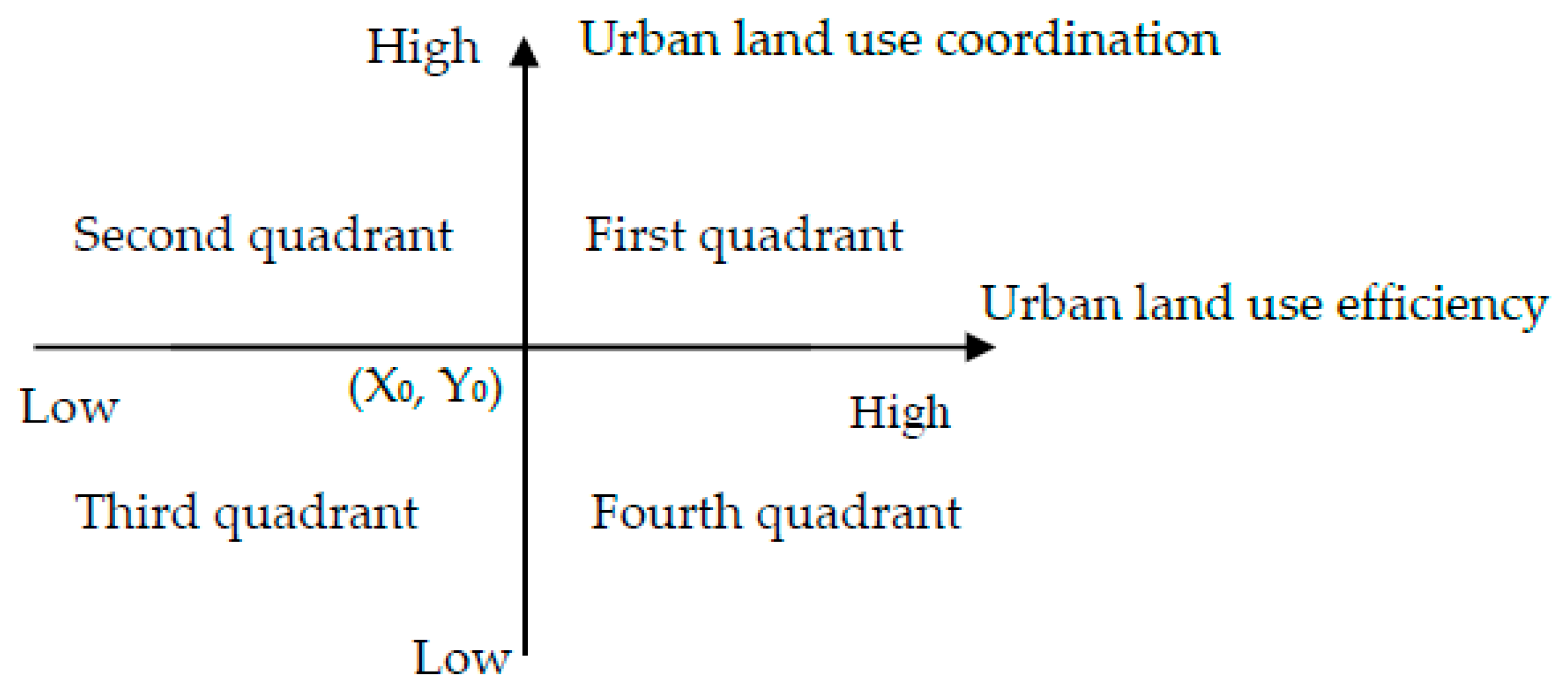
2.4. Evaluation Coordinate System of Urban Land Use Efficiency and Coordination
We employed the Boston matrix method to study urban land use efficiency and coordination, as this method can classify samples according to individual performance in two aspects. We created a coordinate system with land use efficiency as the
x-axis and land use coordination as the
y-axis and plotted the corresponding data of our research subjects. A boundary value was set for both efficiency level and coordination degree (i.e., the coordinate origin (X
0, Y
0)). When the efficiency level (coordination degree) increased beyond this value, the efficiency (coordination) of urban land use is high, and vice versa. This coordinate system is shown in
Figure 1.
2.5. Sample Selection
The samples in our study include 33 provincial capital cities, municipalities, and municipalities with independent planning status in China. The distribution of these cities basically covers the entire Chinese mainland; therefore, these representative cities can objectively reflect the basic situation of land use in China. The socio-economic data employed in this study were assembled from the China Statistical Yearbook and the region Area Statistical Yearbooks. All data of socio-economic indices were confirmed by the Chinese National Bureau of Statistics in 2015, which reflects real values of 2014.
We divided the cities in our sample into three geographical regions as follows: 17 eastern cities include Beijing, Tianjin, Harbin, Shanghai, Nanjing, Hangzhou, Fuzhou, Xiamen, Shenzhen, Haikou, Qingdao, Ningbo, Dalian, Changchun, Jinan, Shijiazhuang, and Shenyang; 6 central cities include Hefei, Nanchang, Wuhan, Taiyuan, Zhengzhou, and Changsha; and 10 western cities include Nanning, Chongqing, Lanzhou, Xi’ning, Yinchuan, Xi’an, Urumqi, Guiyang, Chengdu, and Hohhot.
3. Results
3.1. Urban Land Use Efficiency in China
The DEA method was utilized to analyze the urban land use efficiency in China. The results are shown in
Table 3.
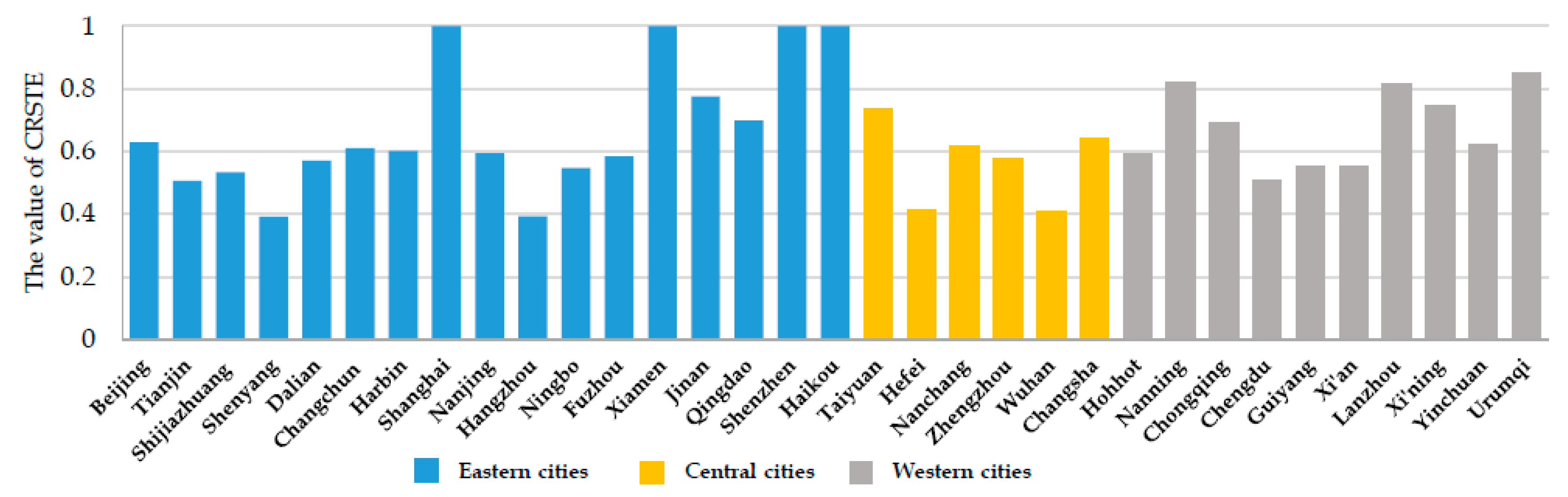
We analyzed these results focusing of Constant Returns to Scale (CRS) and Variable Returns to Scale (VRS). When CRS are constant, technical efficiency (TE) was considered, which stands for comprehensive efficiency. Technical efficiency of individual decision-making units is plotted as a column chart in
Figure 2.
For variable VRS, we considered technical efficiency, which simply refers to the technology. The technical efficiency of individual decision-making units is plotted as a column chart in
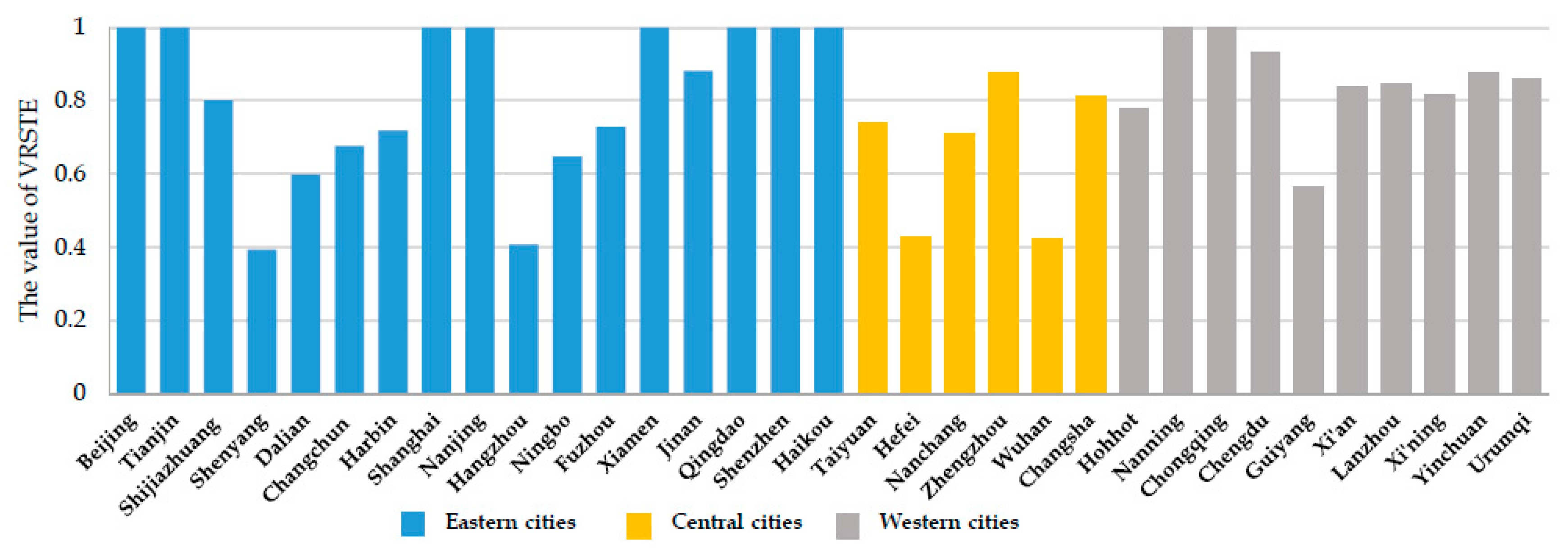
Figure 3.
The land use efficiencies of the cities in our sample vary depending on the region where the city is located. Four (23.5%) of the eastern cities have high land use efficiency (1.0), while five (29.4%) eastern cities have low land use efficiency (<0.80). None of the central cities have high land use efficiency, but two (33.3%) central cities have low land use efficiency. None of the western cities have high land use efficiency, but five (50%) western cities have low land use efficiency. This evident increase in low land use efficiency from eastern to central to western regions is in accordance with the distribution of economic development in China, indicating that lower land use efficiency coincides with areas with lower economic development more so than with areas of higher economic development. We suggest three main reasons for this phenomenon:
Cities with higher economic development have a much more reasonable industrial structure [
44]. In contrast to primary and secondary industries, tertiary industries use higher land productivity per unit area, leading to higher land use efficiency in developed cities.
Cities with higher economic development place more emphasis on the relationship between economic development and social development. The theory of economic development suggests increasing social demands for better infrastructure, better education, and better medical services with the improvement of the level of economic development in a city. This guides local government investment to improve public services, which in turn increases land development intensity and land productivity per unit area [
45].
Cities with higher economic development invested far more in environmental protection, which can also increase land productivity per unit area.
3.2. The Degree of Urban Land Use Coordination in China
We evaluated the coordination level of economic (S1) and social environmental systems (S2) for the urban land use of each city. The results of principal component analysis of the standardized data are shown in
Table 4 and
Table 5. In the extraction process for the economic system, the variance contribution of the first principal component reached 90.075, revealing a good result. Therefore, the first principal component can represent each of the developmental levels of the economic system of a city. The extraction process for the social environmental system revealed a cumulative variance contribution of the first four principal components of 80.277. Therefore, the first four principal components can represent the developmental level of the social environmental system of each city.
According to Equation (2), the horizontal metrics
F1(2014,
xi) and
F2(2014,
yj) are equal to the main factor in the extracted variance contribution–weighted average.
where
ai is the characteristic index weight of S1, which is the principal component variance contribution of S1; and
bj is the characteristic index weight of S2, which is the principal component variance contribution of S2.
We utilized Equation (2) to determine the degree of coordination between the economic system and the social environmental system G (2014), as shown in
Table 6.
The degree of land use coordination of the sampled cities varied according to the region, a given city is located in and its land use efficiency. Five (29.4%) of the eastern cities have relatively high land use coordination degrees (>0.9), while two (11.8%) eastern cities have especially low land use coordination degrees (<−1.0). Two (33.3%) central cities have relatively high land use coordination degrees (>0.9), while four (66.7%) central cities have especially low land use coordination degrees (<−1.0). Two (20.0%) western cities have high land use coordination degrees (>0.9), while two (20.0%) eastern cities have particularly low land use coordination degrees (<−1.0).
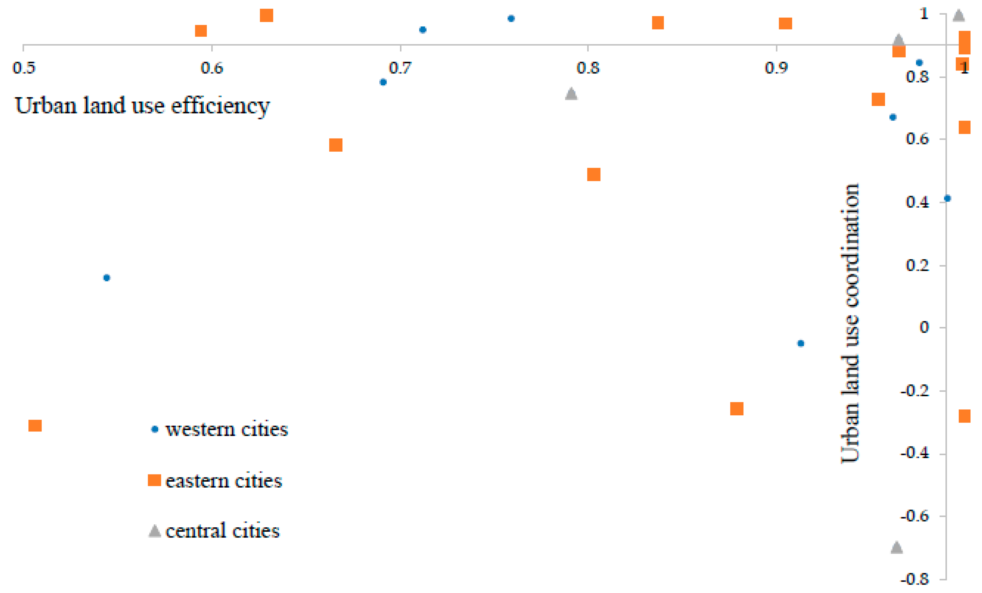
3.3. Urban Land Use Efficiency and Coordination in China
We plotted the values for each city on a coordinate system with urban land use efficiency on the
x-axis and coordination degree on the
y-axis. The origin was defined for efficiency and coordination as values of 0.99 and 0.9, respectively. We detected a wide range of coordination values in our sample; consequently, to arrive at clearer results, we omitted those cities with a coordination value below −1.0. The resulting plot is displayed in
Figure 4.
Based on the above analysis, the cities of our sample can be divided into four categories according to the occupied quadrant of the coordinate system. One (5.9%) eastern city (Shenzhen) is the only city which features both high efficiency and well-coordinated development (with coordinates of 1, >0.9). Three (17.6%) eastern cities have highly efficient but poorly coordinated development (with coordinates of 1, <0.9), including Shanghai, Xiamen, and Haikou. Four (23.5%) eastern cities have inefficient but well-coordinated development (with coordinates of <1, >0.9), including Beijing, Changchun, Harbin, and Nanjing. Two (33.3%) central cities have inefficient but well-coordinated development (with coordinates of <1, >0.9), including Taiyuan and Hefei. Two (20.0%) western cities have inefficient but well-coordinated development (with coordinates of <1, >0.9), including Hohhot and Yinchuan. Nine (52.9%) eastern cities have inefficient and poorly coordinated development (with coordinates of <1, <0.9), including Tianjin, Shijiazhuang, Shenyang, Dalian, Hangzhou, Ningbo, Fuzhou, Jinan, and Qingdao. Four (66.7%) central cities have inefficient and poorly coordinated development (with coordinates of <1, <0.9), including Nanchang, Zhengzhou, Wuhan, and Changsha. Eight (80%) western cities have inefficient and poorly coordinated development (with coordinates of <1, <0.9), including Nanning, Chongqing, Chengdu, Guiyang, Xi’an, Lanzhou, Xi’ning, and Urumqi.
4. Discussion and Conclusions
This study aimed to analyze urban land use efficiency and coordination of China from an economic perspective. The results revealed a gradually increasing proportion of land use efficiency from eastern to central to western regions in China, coinciding with China’s patterns of socioeconomic development. Regions with lower economic development have lower land use efficiency. Moreover, we found a strong correlation between low land use efficiency and low land use coordination. There are nine citiesx which have low land use coordination degrees among twelve cities with low land use efficiency. Furthermore, our results indicate no significant correlation between high levels of urban land use efficiency and land use coordination in our sample. Due to the limited nature of the data, this study does not address the impact of land use types on land use efficiency. Moreover, the development direction of a city is relatively small, with no distinction between resource-based cities or service-oriented cities, etc., which may have an impact on urban land use. Therefore, in future research, factors such as land use type and urban development planning should be taken into account to obtain a more accurate evaluation of land use coordination.
This paper analyzed urban land use efficiency and coordination in China based on a sample of 33 provincial capital cities, municipalities, and municipalities with independent planning status in China. For this, we combined theoretical analysis, data envelopment analysis, principal component analysis, the coordination coefficient method, and four-quadrant analysis. We decomposed the entire system into social, economic, and environmental subsystems via theoretical analysis and employed data envelopment analysis (DEA) to evaluate urban land use efficiency. The results revealed a gradually increasing proportion of low land use efficiency from eastern to central to western regions of China, coinciding with China’s patterns of socioeconomic development (see
Table 3). We employed the coordination coefficient method to study the degree of land use coordination and calculated the land use coordination degree of 33 sample cities (see
Table 6). We employed the Boston matrix method to study urban land use efficiency and coordination (see
Figure 4) and evaluated the coordination level of the economic (S1) and social environmental systems (S2) for the urban land use of each city. The results of a principal component analysis of the standardized data are shown in
Table 4 and
Table 5.
As engines of national economic growth, the local economies of Beijing, Shanghai, Shenzhen, and other core cities in China are directly related to and affect the country as a whole and the regional economic development. These cities are under great pressure to increase economic development and to improve noneconomic urban conditions to keep pace with the fast-growing economy. Therefore, although these cities feature high economic development, reflected in high land use efficiency, such development is generally not well coordinated. When urban land use lacks efficiency, local governments tend to intensify their efforts to develop the urban land, thus over-emphasizing economic returns, while neglecting other aspects of city construction. Such practices lead to ever-present problems, e.g., lack of public service, environmental pollution, and low land use coordination.
The policy implications are clear. First, the Chinese government should strengthen the scientific basis of urban land use planning and improve its enforcement. Rational urban land use planning is vital to the effective operation of a city [
46]. Coordinated economic, social, and environmental urban development should also be considered. However, under China’s existing fiscal decentralization policy, the central government’s assessment of local officials is assumed to be GDP-oriented, which inevitably leads to an emphasis on economic construction at the expense of other aspects of urban planning. Therefore, the central government and all levels of government should increase supervision of urban land use planning of local governments and guide them to optimize urban land use planning in line with the individual characteristics of a city. Furthermore, the single GDP-oriented assessment of local officials needs to change. Instead, local officials should be guided to plan for the long-term development of their city to achieve long-lasting, efficient, and coordinated development.
Second, the independence of land management agencies should be promoted and a system of dual supervision by both the government and the public should be established. One reason for the severe urban land use problem in China is that local governments are both law enforcers and offenders. Local land management agencies are subordinates of local governments and cannot effectively constrain the behavior of local governments. Thus, the vertical management functions of land management agencies should be strengthened to promote independence of such agencies, consequently weakening or eliminating intervention by the local government. China can also learn from the successful land management efforts of other countries and establish a regime with a Land Management Commissioner.
Third, suppressing the investment impulses of local governments and strengthening governmental management functions are effective ways to promote land use. One central problem that currently affects China is that local governments have diverted extensive energy and resources to the economy, while neglecting the development of social undertakings and environmental protection, resulting in difficulties in developmental coordination among these three systems [
47,
48]. To address this situation, the GDP-oriented developmental approach to economic development should be reformed to suppress the investment impulsion of local governments. Local governments should also adjust their allocation of fiscal expenditures to improve public services and environmental protection, thus transitioning from a production-oriented government to a service-oriented government.
Finally, organizations outside of government agencies should be encouraged to play a more prominent role in the development of social undertakings and environmental protection, thus counteracting the adverse impact of governmental absence in urban development. The government could support such efforts by offering positive publicity, funding, and tax benefits.
Since the proposed Boston matrix method of urban land use efficiency and coordination of ideas is still in development, the resulting ideas and methods of this study are innovative and exploratory. To optimize the effectiveness of this relatively simple method for application to management practice, further in-depth studies should employ an improved research methodology via inter alia, independent evaluation of each city.


