Revisiting Ecosystem Services: Assessment and Valuation as Starting Points for Environmental Politics


Abstract
1. Introduction
“We want to make clear that expressing the value of ecosystem services in monetary units does not mean that they should be treated as private commodities that can be traded in private markets… Even if fish and other provisioning services enter the market as private goods, the ecosystems that produce them (i.e., coastal systems and oceans) are common assets. Their value in monetary units is an estimate of their benefits to society expressed in units that communicate with a broad audience… to inform better, more balanced decisions regarding trade-offs with policies that enhance GDP but damage ecosystem services”.[15] (p. 157)
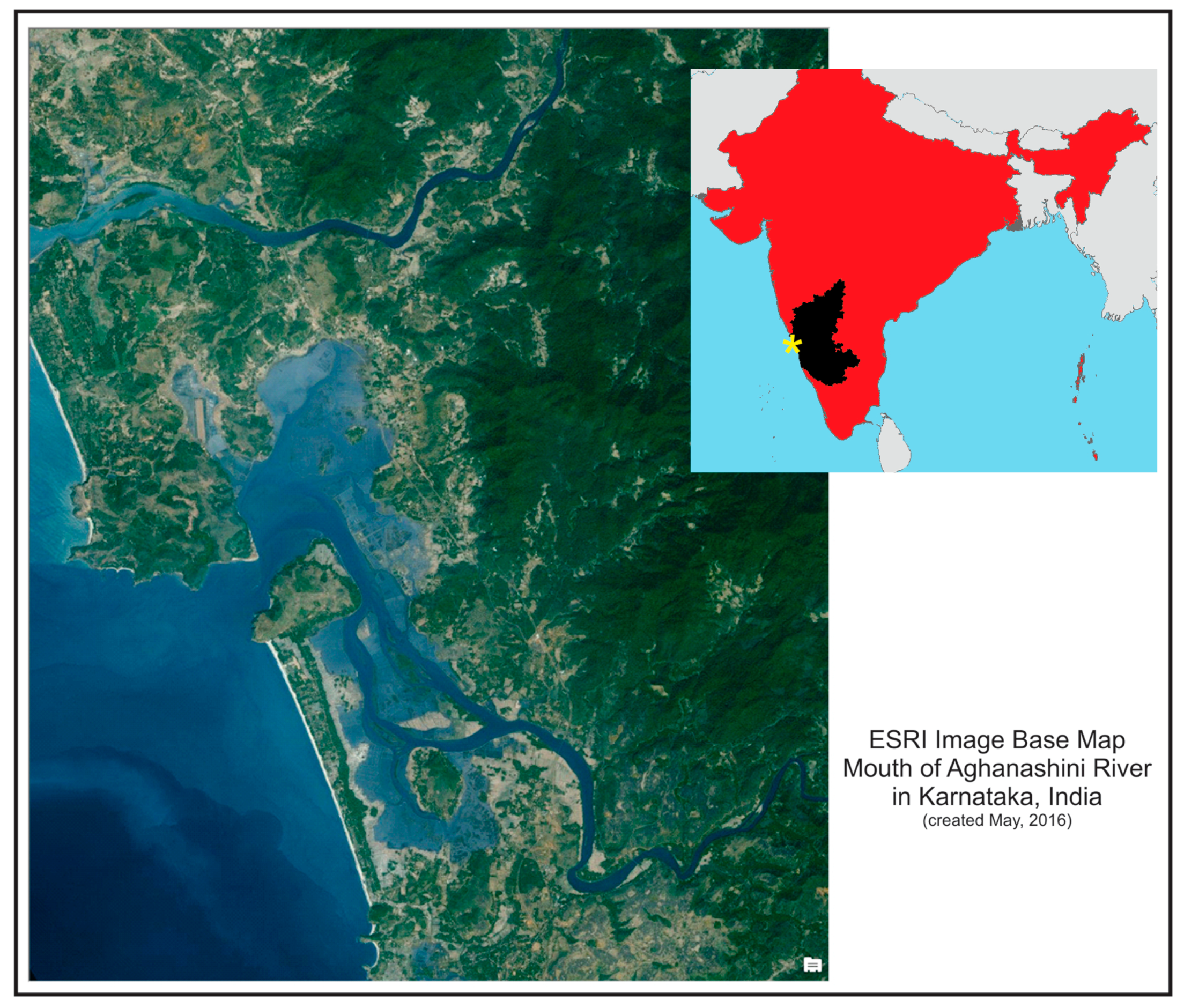
2. Study Context
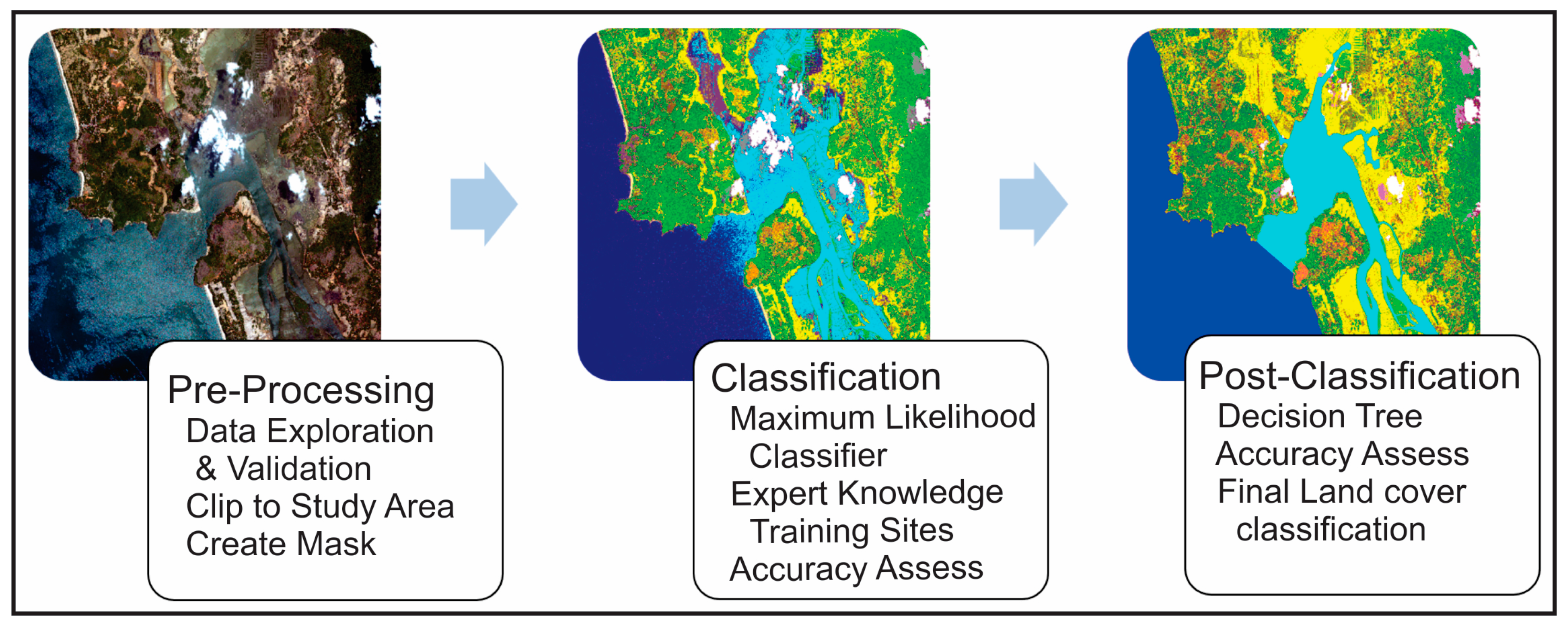
3. Materials and Methods
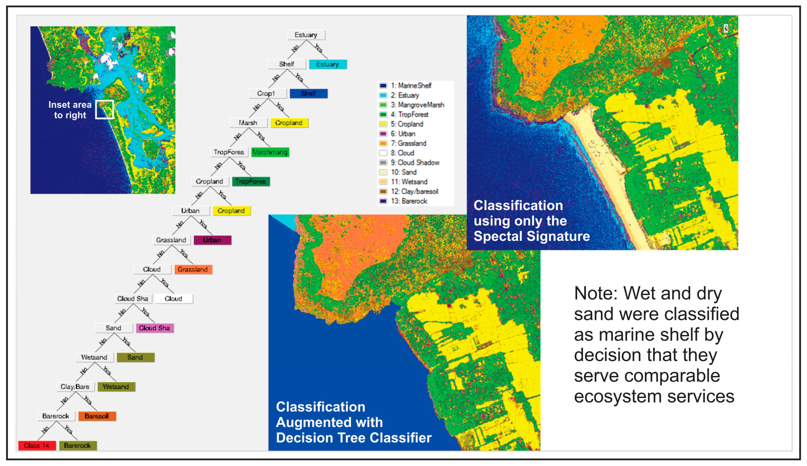
3.1. Land-Cover Classification
3.2. Benefit Transfer
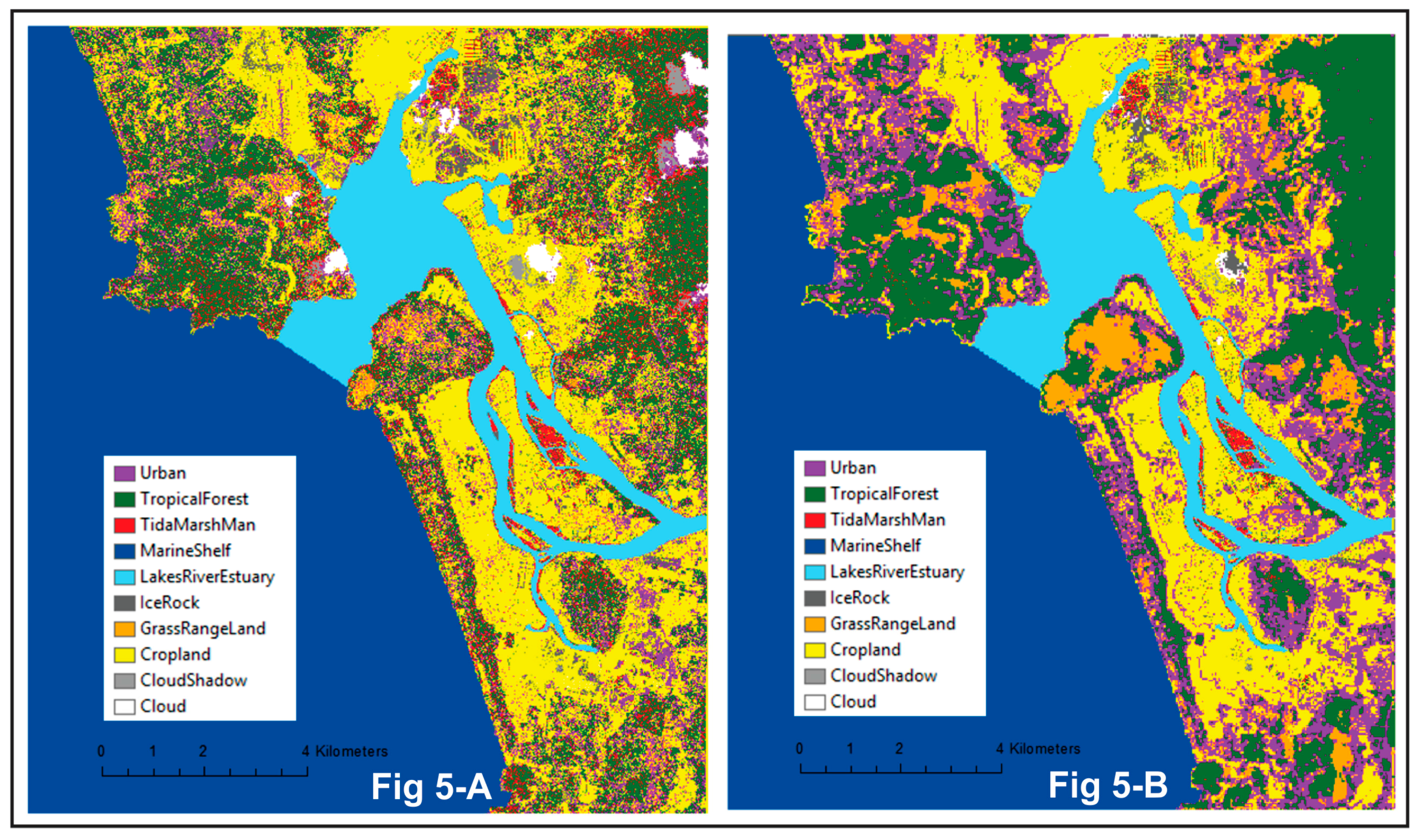
4. Results
5. Discussion
ES Valuation in Environmental Politics
“It is very evident that either due to ignorance or design, the EIA team… presented a seriously erroneous picture, particularly of the estuarine ecology and also biodiversity of the adjoining lands integral to the estuarine system. The team also failed to provide a convincing picture of the socio-economic implications on the community that would ensue the port execution. Yet, with all these glaring shortcomings in the EIA study, the proponents and the consultants were able to secure a favourable recommendation [from a government project review committee] for execution of the port project, which would amount to large scale destruction of the estuarine system and inflict serious livelihood consequences in the coastal zone”.[96] (p. 12)
6. Conclusions
Acknowledgments
Author Contributions
Conflicts of Interest
References and Notes
- Hansen, M.C.; Potapov, P.V.; Moore, R.; Hancher, M.; Turubanova, S.A.; Tyukavina, A.; Thau, D.; Stehman, S.V.; Goetz, S.J.; Loveland, T.R.; et al. High-resolution global maps of 21st-century forest cover change. Science 2013, 342, 850–853. [Google Scholar] [CrossRef] [PubMed]
- Halpern, B.; Walbridge, S.; Selkoe, K.A.; Kappel, C.V.; Micheli, F.; D’Agrosa, C.; Bruno, J.F.; Casey, K.S.; Ebert, C.; Fox, H.E.; et al. A global map of human impact on marine ecosystems. Science 2008, 319, 948–952. [Google Scholar] [CrossRef] [PubMed]
- Lambin, E.; Meyfroidt, P. Global land use change, economic globalization, and the looming land scarcity. Proc. Natl. Acad. Sci. USA 2011, 108, 3465–3472. [Google Scholar] [CrossRef] [PubMed]
- Thomas, W.L. Man’s Role in Changing the Face of the Earth; University of Chicago: Chicago, IL, USA, 1956. [Google Scholar]
- Jha, C.S.; Dutt, C.B.S.; Bawa, S.K. Deforestation and land use changes in Western Ghats, India. Curr. Sci. 2000, 79, 231–238. [Google Scholar]
- Foley, J.A.; DeFries, R.; Asner, G.P.; Barford, C.; Bonan, G.; Carpenter, S.R.; Chapin, F.S.; Coe, M.T.; Daily, G.C.; Gibbs, H.K.; et al. Global consequences of land use. Science 2005, 309, 570–574. [Google Scholar] [CrossRef] [PubMed]
- Costanza, R.; d’Arge, R.; de Groot, R.; Farber, S.; Grasso, M.; Hannon, B.; Limburg, K.; Naeem, S.; O’Neill, R.; Paruelo, J.; et al. The value of the world’s ecosystem services and natural capital. Nature 1997, 387, 253–260. [Google Scholar] [CrossRef]
- Daily, G. (Ed.) Nature’s Services: Societal Dependence on Natural Ecosystems; Island Press: Washington, DC, USA, 1997. [Google Scholar]
- Millennium Ecosystem Assessment (MEA). Ecosystems and Human Well-Being: Synthesis; Island Press: Washington, DC, USA, 2005. [Google Scholar]
- Braat, L.; de Groot, R. The ecosystem services agenda: Bridging the worlds of natural science and economics, conservation and development, and public and private policy. Ecosyst. Serv. 2012, 1, 4–15. [Google Scholar] [CrossRef]
- Kumar, P.; Martinez-Alier, J. The economic of ecosystem services and biodiversity: An international assessment. Econ. Political Wkly. 2011, 46, 76–80. [Google Scholar]
- Abson, D.J.; von Wehrdena, H.; Baumgärtner, S.; Fischer, J.; Hanspach, J.; Härdtle, W.; Heinrichs, H.; Klein, A.M.; Langa, D.J.; Martens, P.; et al. Ecosystem services as a boundary object for sustainability. Ecol. Econ. 2014, 103, 29–37. [Google Scholar] [CrossRef]
- Schröter, M.; van der Zanden, E.; van Oudenhoven, A.; Remme, R.; Serna-Chavez, H.; de Groot, R.; Opdam, P. Ecosystem services as a contested concept: A synthesis of critique and counter-arguments. Conserv. Lett. 2014, 7, 514–523. [Google Scholar] [CrossRef]
- TEEB Synthesis. Mainstreaming the Economics of Nature: A Synthesis of the Approach, Conclusions and Recommendations of TEEB; Earthscan Publications Ltd.: London, UK; Washington, DC, USA, 2010. [Google Scholar]
- Costanza, R.; de Groot, R.; Sutton, P.; van der Ploeg, S.; Anderson, S.; Kubiszewski, I.; Farber, S.; Turner, R. Changes in the global value of ecosystem services. Glob. Environ. Chang. 2014, 26, 152–158. [Google Scholar] [CrossRef]
- De Groot, R.; Brander, L.; van der Ploeg, S.; Costanza, R.; Bernard, F.; Braat, L.; Christie, M.; Crossman, N.; Ghermandi, A.; Hein, L.; et al. Global estimates of the value of ecosystems and their services in monetary units. Ecosyst. Serv. 2012, 1, 50–61. [Google Scholar] [CrossRef]
- Barbier, E. Capitalizing on Nature: Ecosystems as Natural Assets; Cambridge University Press: Cambridge, UK, 2011. [Google Scholar]
- Díaz, S.; Demissew, S.; Carabias, J.; Joly, C.; Lonsdale, M.; Ash, N.; Larigauderie, A.; Adhikari, J.R.; Arico, S.; Báldi, A.; et al. The IPBES Conceptual Framework—Connecting nature and people. Curr. Opin. Environ. Sustain. 2015, 14, 1–16. [Google Scholar] [CrossRef]
- Díaz, S.; Demissew, S.; Joly, C.; Lonsdale, W.M.; Larigauderie, A. A Rosetta Stone for nature’s benefits to people. PLoS Biol. 2015, 13, e1002040. [Google Scholar] [CrossRef] [PubMed]
- Pascual, U.; Balvanera, P.; Díaz, S.; Pataki, G.; Roth, E.; Stenseke, M.; Watson, R.T.; Dessane, E.B.; Islar, M.; Kelemen, E.; et al. Valuing nature’s contributions to people: The IPBES approach. Curr. Opin. Environ. Sustain. 2017, 26, 7–16. [Google Scholar] [CrossRef]
- Heynen, N.; Robbins, P. The neoliberalization of nature: Governance, privatization, enclosure and valuation. Capital. Nat. Soc. 2005, 16, 5–8. [Google Scholar] [CrossRef]
- Gómez-Baggethun, E.; Ruiz-Pérez, M. Economic valuation and the commodification of ecosystem services. Prog. Phys. Geogr. 2011, 35, 613–628. [Google Scholar] [CrossRef]
- Spash, C. The new environmental pragmatists, pluralism and sustainability. Environ. Values 2009, 18, 253–256. [Google Scholar] [CrossRef]
- Neimeyer, S.; Spash, C. Environmental valuation analysis, public deliberation and their pragmatic synthesis: A critical appraisal. Environ. Plan. C Gov. Policy 2001, 19, 567–585. [Google Scholar] [CrossRef]
- Vatn, A. The environment as a commodity. Environ. Values 2000, 9, 493–509. [Google Scholar] [CrossRef]
- Spash, C.; Vatn, A. Transferring environmental value estimates: Issues and alternatives. Ecol. Econ. 2006, 60, 379–388. [Google Scholar] [CrossRef]
- Das, S. The strange valuation of forests in India. Econ. Political Wkly. 2010, 45, 16–18. [Google Scholar]
- De Groot, R.; Alkemade, R.; Braat, L.; Hein, L.; Willemen, L. Challenges in integrating the concept of ecosystem services and values in landscape planning, management and decision making. Ecol. Complex. 2010, 7, 260–272. [Google Scholar] [CrossRef]
- Robbins, P. Fixed categories in a portable landscape: The causes and consequences of land-cover categorization. Environ. Plan. A 2001, 33, 161–179. [Google Scholar] [CrossRef]
- Hejnowicz, A.P.; Rudd, M.A. The value landscape in ecosystem services: Value, value wherefore art thou value? Sustainability 2017, 9, 850. [Google Scholar] [CrossRef]
- Castree, N. Neoliberalising nature: The logics of deregulation and reregulation. Environ. Plan. A 2008, 40, 131–152. [Google Scholar] [CrossRef]
- Castree, N. Neoliberalising nature: Processes, effects, and evaluations. Environ. Plan. A 2008, 40, 153–173. [Google Scholar] [CrossRef]
- Walker, J. Bringing liquidity to life: Markets for ecosystem services and the new political economy of extinction. In Business Interests and the Environmental Crisis; Kohli, K., Menon, M., Eds.; Sage: New Delhi, India, 2016; pp. 3–27. [Google Scholar]
- Bakker, K. The limits of ‘neoliberal natures’: Debating green neoliberalism. Prog. Hum. Geogr. 2010, 34, 715–735. [Google Scholar] [CrossRef]
- Dempsey, J.; Robertson, M. Ecosystem services: Tensions, impurities, and points of engagement within neoliberalism. Prog. Hum. Geogr. 2012, 36, 758–779. [Google Scholar] [CrossRef]
- Kull, C.A.; de Sartre, X.A.; Castro-Larrañaga, M. The political ecology of ecosystem services. Geoforum 2015, 61, 122–134. [Google Scholar] [CrossRef]
- Norgaard, R. Ecosystem services: From eye-opening metaphor to complexity blinder. Ecol. Econ. 2010, 69, 1219–1227. [Google Scholar] [CrossRef]
- Ostrom, E. Governing the Commons: The Evolution of Institutions for Collective Action; Cambridge University Press: Cambridge, UK, 1990. [Google Scholar]
- Scott, J. Seeing Like a State: How Certain Schemes to Improve the Human Condition Have Failed; Yale University Press: New Haven, CT, USA, 1999. [Google Scholar]
- Thiemea, M.; Lehnera, B.; Abella, R.; Hamilton, S.K.; Kellndorferd, J.; Powella, G.; Riveros, J.C. Freshwater conservation planning in data-poor areas: An example from a remote Amazonian basin (Madre de Dios River, Peru and Bolivia). Biol. Conserv. 2007, 135, 484–501. [Google Scholar] [CrossRef]
- Termorshuizen, J.; Opdam, P. Landscape services as a bridge between landscape ecology and sustainable development. Landsc. Ecol. 2009, 24, 1037–1052. [Google Scholar] [CrossRef]
- Shrivastava, A.; Kothari, A. Churning the Earth: The Making of Global India; Penguin: New Delhi, India, 2012. [Google Scholar]
- World Bank Disaster Management and Climate Change Unit. India Diagnostic Assessment of Selected Environmental Challenges: An Analysis of Physical and Monetary Losses of Environmental Health and Natural Resources; Report No. 70004-IN; World Bank: New Delhi, India, 2013; Volume 1. [Google Scholar]
- Gadgil, M.; Guha, R. The Use and Abuse of Nature, Incorporating This Fissured Land: An Ecological History of India and Ecology and Equity; Oxford University Press: New Delhi, India, 2005. [Google Scholar]
- Kurien, J. Are our seas up for grabs? Econ. Political Wkly. 2015, 50, 15–18. [Google Scholar]
- Sridhar, A.; Menon, M.; Rodriguez, S. Coastal zone management: Better or bitter fare? Econ. Political Wkly. 2007, 42, 3838–3840. [Google Scholar]
- Cook, I.; Bhatta, R.; Dinker, V. The multiple displacements of the Mangalore Special Economic Zone. Econ. Political Wkly. 2013, 48, 40–46. [Google Scholar]
- Kundu, R.; Sahu, G. Selective inclusions and exclusions: Land-use planning and development in Ratnagiri. Econ. Political Wkly. 2014, 49, 69–76. [Google Scholar]
- Robson, J.; Nayak, P. Rural out-migration and resource-dependent communities in Mexico and India. Popul. Environ. 2010, 32, 263–284. [Google Scholar] [CrossRef]
- Chandran, M.; Mesta, P.; Boominathan, M.; Rao, G.; Vishnu, D.; Ramachandra, T. Aghanashini Estuary in Kumta Taluk, Uttara Kannada—Biological Heritage Site; ENVIS Technical Report No. 35; Indian Institute of Science Centre for Ecological Sciences: Bangalore, India, 2012. [Google Scholar]
- Office of the Registrar General and Census Commissioner, India. Census of India. Primary Census Abstract 2011. Available online: http://censusindia.gov.in (accessed on 17 April 2017).
- Field observations and interviews come from extended participant observation, interviews conducted by a research team and other NGO research and conservation programming from January 2015 to July 2016.
- Chandran, M.; Ramachandra, T.; Joshi, N.; Mesta, P.; Settur, B.; Vishnu, D. Conservation and Management of Mangroves in Uttara Kannada, Central Western Ghats; ENVIS Technical Report No. 50; Indian Institute of Science Centre for Ecological Sciences: Bangalore, India, 2012. [Google Scholar]
- Bhat, M.; Nayak, V.; Chandran, M.; Ramachandra, T. Fish distribution dynamics in the Aghanashini estuary of Uttara Kannada, west coast of India. Curr. Sci. 2014, 106, 1739–1744. [Google Scholar]
- Boominathan, M.; Chandran, M.; Ramachandra, T. Economic Valuation of Bivalves in the Aghanashini Estuary, West Coast, Karnataka; ENVIS Technical Report No. 30; Indian Institute of Science Centre for Ecological Sciences: Bangalore, India, 2008. [Google Scholar]
- Rangarajan, M.; Sivaramakrishnan, K. (Eds.) India’s Environmental History; Permanent Black: Ranikhet, India, 2012; Volumes 1 and 2. [Google Scholar]
- Jadhav, A. Coastal development in Karnataka: Seeing neoliberalism through legal plural eyes. In Proceedings of the International Conference of the Commission on Legal Pluralism, Mumbai, India, 14–16 December 2015. [Google Scholar]
- National Environmental Engineering Research Institute (NEERI). Environmental Impact Assessment Studies for Development of Sea Port at Tadadi, Karwar, Karnataka; Karnataka State Industrial and Infrastructure Development Corporate, Ltd.: Bangalore, India, 2012. [Google Scholar]
- Jadhav, A. Place-based perceptions of estuarine conservation in India: “We don’t threaten mangroves; mangroves threaten us”. In Proceedings of the Annual Meeting of the American Association of Geographers, Boston, MA, USA, 21–25 April 2015. [Google Scholar]
- Menon, M.; Kohli, K. A strange proposal to build Karnataka's largest port raises serious (and awkward) questions. Scroll.in. 22 March 2015. Available online: https://scroll.in/article/715364/ (accessed on 17 April 2017).
- Even as we write this paper, coastal development regulations were undergoing revisions by government technocrats that are widely seen as diluting protections of livelihoods and natural resources, further calling into question sustainable coastal development. Sinha, A.; Ranjan, A. “Govt plans to ease coastal rules, allow land reclamation for commercial use”. The Indian Express. 22 March 2017. Available online: http://indianexpress.com/article/india/govt-plans-to-ease-coastal-rules-allow-land-reclamation-for-commercial-use-4579820/s (accessed on 17 April 2017).
- Ramesh, J. The two cultures revisited: The environment-development debate in India. Econ. Political Wkly. 2010, 45, 13–16. [Google Scholar]
- ISRO. Coastal Zones of India; Indian Space Applications Centre: Ahmedabad, India, 2012.
- For example, mapping projects and social ecology surveys by the National Centre for Sustainable Coastal Management, though mandated under Indian regulations and by courts for years, continue to be embroiled in ongoing controversies.
- Badola, R.; Hussain, S. Valuing ecosystem functions: An empirical study on the storm protection function of Bhitarkanika mangrove ecosystem, India. Environ. Conserv. 2005, 32, 85–92. [Google Scholar] [CrossRef]
- Lele, S.; Patil, I.; Badiger, S.; Menon, A.; Kumar, R. Forests, hydrological services, and agricultural Income: A case study from Mysore district of the Western Ghats of India. In Environmental Valuation in South Asia; Haque, A., Murty, M., Shyamsundar, P., Eds.; Cambridge University Press: Cambridge, UK, 2011; pp. 141–169. [Google Scholar]
- Maharana, I.; Rai, S.; Sharma, E. Valuing ecotourism in a sacred lake of the Sikkim Himalaya, India. Environ. Conserv. 2000, 27, 269–277. [Google Scholar] [CrossRef]
- Ghermandi, A.; Sheela, A.M.; Justus, J. Integrating similarity analysis and ecosystem service value transfer: Results from a tropical coastal wetland in India. Ecosyst. Serv. 2016, 22A, 73–82. [Google Scholar] [CrossRef]
- TEEB Foundations. The Economics of Ecosystems and Biodiversity: Ecological and Economic Foundations; Earthscan Publications Ltd.: London, UK, 2010. [Google Scholar]
- Kuppusamy, S.; Johnson, J.A.; Pande, A. Research gaps in coastal and marine conservation in India. In Coastal and Marine Protected Areas in India: Challenges and Way Forward; Sivakumar, K., Ed.; Wildlife Institute of India: Dehradun, India, 2013; pp. 230–241. [Google Scholar]
- For example, he EIA for the Aghanashini port proposal put forward to a public hearing in 2015 contained outright plagiarism, lifting wholesale a policy and economic paper on bivalves in the estuary from scientists at the Indian Institute of Science, while still grossly under-estimating the number of fishers in the estuary.
- Johannes, R.E. The case for data-less marine resource management: Examples from tropical nearshore finfisheries. TREE 1998, 13, 243–246. [Google Scholar] [CrossRef]
- Kumar, M.; Saravanan, K.; Jayaraman, N. Mapping the coastal commons: Fisherfolk and the politics of coastal urbanization in Chennai. Econ. Political Wkly. 2014, 49, 46–53. [Google Scholar]
- This high-resolution multi-spectral imagery was specifically provided by data grant from the Digital Globe Foundation.
- Story, M.; Congalton, R. Accuracy Assessment: A user’s perspective. Photogramm. Eng. Remote Sens. 1986, 52, 397–399. [Google Scholar]
- Richardson, L.; Loomis, J.; Kroeger, T.; Casey, F. The role of benefit transfer in ecosystem service valuation. Ecol. Econ. 2015, 115, 51–58. [Google Scholar] [CrossRef]
- Rosenberger, R.; Loomis, J. Benefit transfer. In A Primer on Nonmarket Valuation; Champ, P.A., Boyle, K.J., Brown, T.C., Eds.; Kluwer Academic Publishers: Boston, MA, USA, 2003; pp. 395–444. [Google Scholar]
- Johnston, R.J.; Rosenberger, R. Methods, trends, and controversies in contemporary benefit transfer. J. Econ. Surv. 2010, 24, 479–510. [Google Scholar] [CrossRef]
- Ninan, K.N.; Kontoleon, A. Valuing forest ecosystem services and disservices—Case study of a protected area in India. Ecosyst. Serv. 2016, 20, 1–14. [Google Scholar] [CrossRef]
- Kubiszewski, I.; Costanza, R.; Dorji, P.; Thoennes, P.; Tshering, K. An initial estimate of the value of ecosystem services in Bhutan. Ecosyst. Serv. 2013, 3, e11–e21. [Google Scholar] [CrossRef]
- Sangha, K.K.; Russell-Smith, J.; Morrison, S.; Costanza, R.; Edwards, A. Challenges for valuing ecosystem services from an Indigenous estate in northern Australia. Ecosyst. Serv. 2017, 25, 167–178. [Google Scholar] [CrossRef]
- Bauer, D.; Johnston, R. The economics of rural and agricultural ecosystem services: Purism versus practicality. Agric. Resour. Econ. Rev. 2013, 42, 3–15. [Google Scholar] [CrossRef]
- Loomis, J.; Richardson, L.; Kroeger, T.; Casey, F. Valuing ecosystem services using benefit transfer: Separating credible and incredible approaches. In Valuing Ecosystem Services: Methodological Issues and Case Studies; Ninan, K.N., Ed.; Edward Elgar Publishing: Northampton, MA, USA, 2014; pp. 78–89. [Google Scholar]
- Sutton, P. Space matters: Exploring problematic spatial issues in the valuation of ecosystem services. In Valuing Ecosystem Services: Methodological Issues and Case Studies; Ninan, K.N., Ed.; Edward Elgar Publishing: Northampton, MA, USA, 2014; pp. 132–147. [Google Scholar]
- Konarska, K.; Sutton, P.; Castellon, M. Evaluating scale dependence of ecosystem service valuation: A comparison of NOAA-AVHRR and Landsat TM datasets. Ecol. Econ. 2002, 41, 491–507. [Google Scholar] [CrossRef]
- Reserve Bank of India. Historical Exchange Rate Data. Available online: https://www.rbi.org.in/scripts/PublicationsView.aspx?id=15268 (accessed on 16 May 2017).
- Barbier, E.; Hacker, S.; Kennedy, C.; Koch, E.; Stier, A.; Silliman, B. The value of estuarine and coastal ecosystem services. Ecol. Monogr. 2011, 81, 169–193. [Google Scholar] [CrossRef]
- Government of Karnataka. Uttara Kannada District Human Development Report 2014; Planning, Programme Monitoring and Statistics Department: Bangalore, India, 2015.
- Myers, N. Environmental refugees: A growing phenomenon of the 21st century. Philos. Trans. R. Soc. B 2002, 357, 609–613. [Google Scholar] [CrossRef] [PubMed]
- Sassen, S. Explusions: Brutality and Complexity in the Global Economy; Belknap: Cambridge, UK, 2014. [Google Scholar]
- Coscieme, L.; Pulselli, F.; Niccolucci, V.; Patrizi, N.; Sutton, P. Accounting for ‘land-grabbing’ from a biocapacity viewpoint. Sci. Total Environ. 2016, 539, 551–559. [Google Scholar] [CrossRef] [PubMed]
- Government of Karnataka. Proceedings of the 10th Meeting of the Karnataka State Coastal Zone Management Authority; Government of Karnataka: Bangalor, India, 2015.
- Hegde, B. Proposal for Declaration of Aghanashini Estuary as Critically Vulnerable Coastal Area (CVCA) under CRZ Notification 2011; Snehakunja Trust: Honnavar, India, 2014. [Google Scholar]
- Peluso, N.L. Whose woods are these? Counter-mapping forest territories in Kalimantan, Indonesia. Antipode 1995, 27, 383–406. [Google Scholar] [CrossRef]
- Harris, L.M.; Hazen, H.D. Power of maps: (Counter) mapping for conservation. ACME 2006, 4, 99–130. [Google Scholar]
- Though the letter was delivered to officials in February 2017 and circulated among activists and researchers, we choose to provide the author the protection of anonymity under our own research ethics.
- Harvey, D. The “new” imperialism: Accumulation by dispossession. Soc. Regist. 2004, 40, 63–87. [Google Scholar]
- Berbés-Blázquez, M.; González, J.; Pascual, U. Towards an ecosystem services approach that addresses social power relations. Curr. Opin. Environ. Sustain. 2016, 19, 134–143. [Google Scholar] [CrossRef]


| Parameters | Landsat 8 OLI | WorldView-3 |
|---|---|---|
| Spatial Resolution | 30 m | 1.24 m |
| Spectral Window | 0.433–2.3 µm | 0.400–1.040 µm |
| Number of Bands | 8 | 8 |
| Radiometric Resolution | 16 bit | 11 bit |
| Date of Acquisition | 1 April 2015 | 28 April 2015 |
| Land Cover/Biome | Area (Hectares) | Value of ES per Hectare (in 2007 US$) | Aggregate ES Value (in 2007 US$) |
|---|---|---|---|
| Tidal/Marsh/Mangroves | 749 | 193,843 | 145,122,646 |
| Urban | 1297 | 6661 | 8,636,490 |
| Lake/River/Estuary | 1482 | 28,916 | 42,860,134 |
| Cropland | 4297 | 5567 | 23,922,321 |
| Tropical Forest | 3156 | 5382 | 16,987,894 |
| Grass/Range Land | 237 | 4166 | 988,044 |
| Ice/Rock | 510 | 0 | 0 |
| Marine Shelf | 8448 | 2222 | 18,771,116 |
| TOTAL | 257,288,646 |
| Land Cover/Biome | Area (Hectares) | Value of ES per Hectare (in 2007 US$) | Aggregate ES Value (in 2007 US$) |
|---|---|---|---|
| Tidal/Marsh/Mangroves | 936 | 193,843 | 181,506,831 |
| Urban | 2771 | 6661 | 18,454,700 |
| Lake/River/Estuary | 1485 | 28,916 | 42,927,248 |
| Cropland | 2763 | 5567 | 15,380,619 |
| Tropical Forest | 3097 | 5382 | 16,669,453 |
| Grass/Range Land | 955 | 4166 | 3,977,738 |
| Ice/Rock | 117 | 0 | 0 |
| Marine Shelf | 8456 | 2222 | 18,788,321 |
| TOTAL | 297,704,911 |
© 2017 by the authors. Licensee MDPI, Basel, Switzerland. This article is an open access article distributed under the terms and conditions of the Creative Commons Attribution (CC BY) license (http://creativecommons.org/licenses/by/4.0/).
Share and Cite
Jadhav, A.; Anderson, S.; Dyer, M.J.B.; Sutton, P.C. Revisiting Ecosystem Services: Assessment and Valuation as Starting Points for Environmental Politics. Sustainability 2017, 9, 1755. https://doi.org/10.3390/su9101755
Jadhav A, Anderson S, Dyer MJB, Sutton PC. Revisiting Ecosystem Services: Assessment and Valuation as Starting Points for Environmental Politics. Sustainability. 2017; 9(10):1755. https://doi.org/10.3390/su9101755
Chicago/Turabian StyleJadhav, Adam, Sharolyn Anderson, Michael J. B. Dyer, and Paul C. Sutton. 2017. "Revisiting Ecosystem Services: Assessment and Valuation as Starting Points for Environmental Politics" Sustainability 9, no. 10: 1755. https://doi.org/10.3390/su9101755
APA StyleJadhav, A., Anderson, S., Dyer, M. J. B., & Sutton, P. C. (2017). Revisiting Ecosystem Services: Assessment and Valuation as Starting Points for Environmental Politics. Sustainability, 9(10), 1755. https://doi.org/10.3390/su9101755