
Predicting the Potential Distribution of Olea ferruginea in Pakistan incorporating Climate Change by Using Maxent Model

Abstract
:1. Introduction
2. Materials and Methods
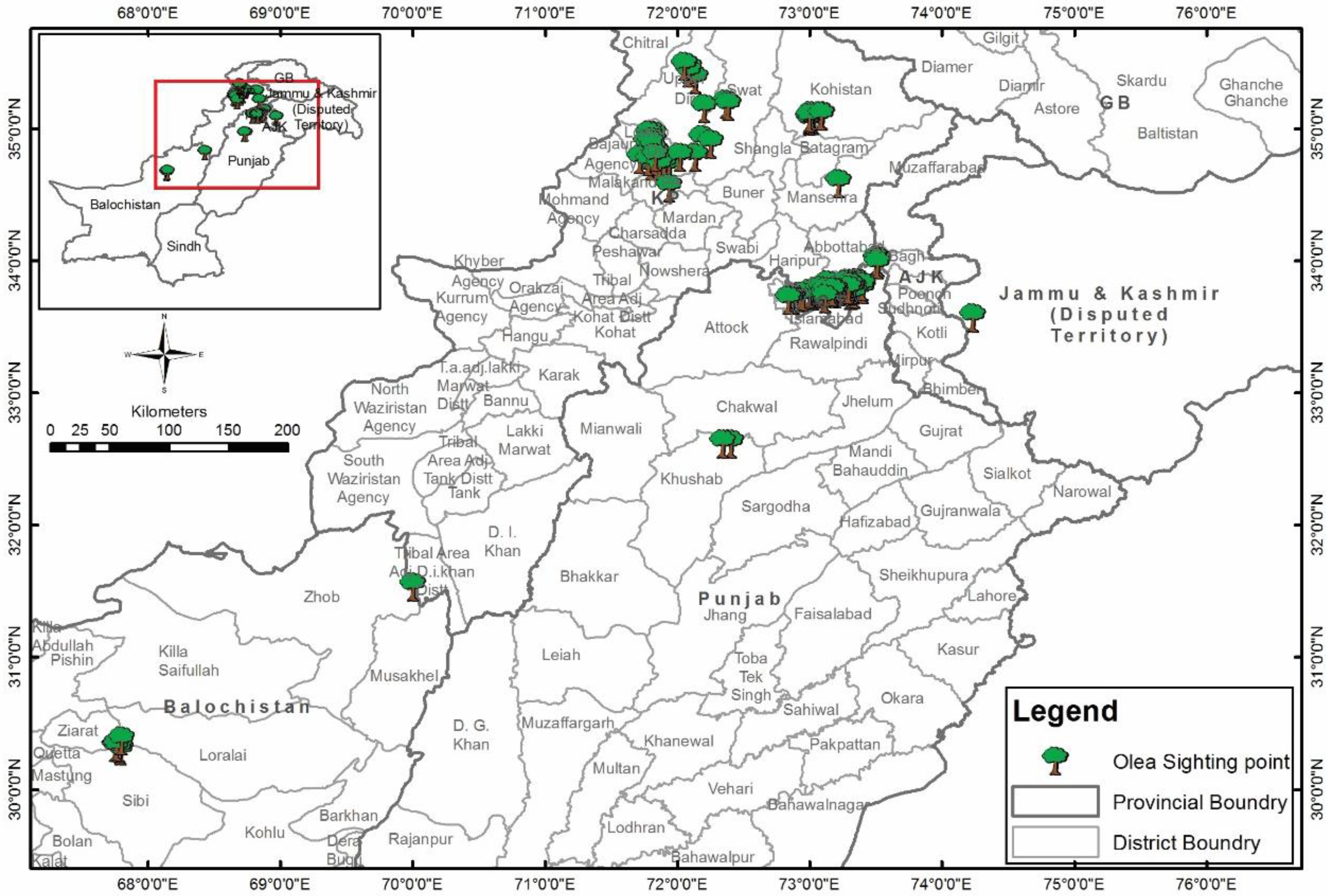
2.1. Data Collection
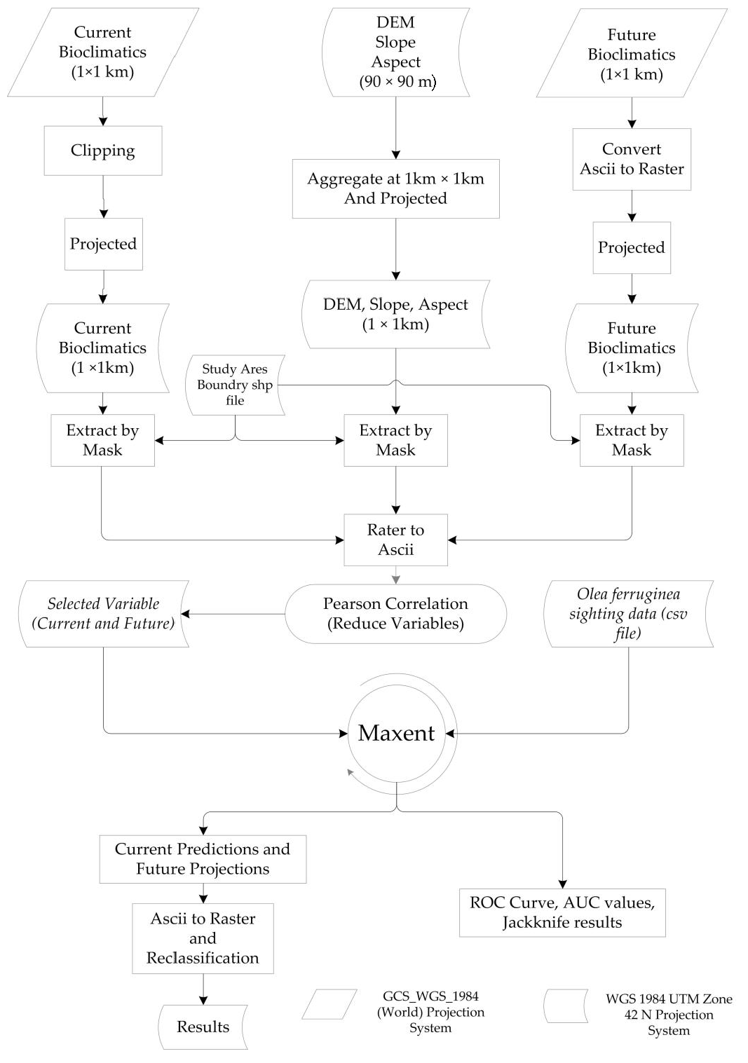
2.2. Data Processing
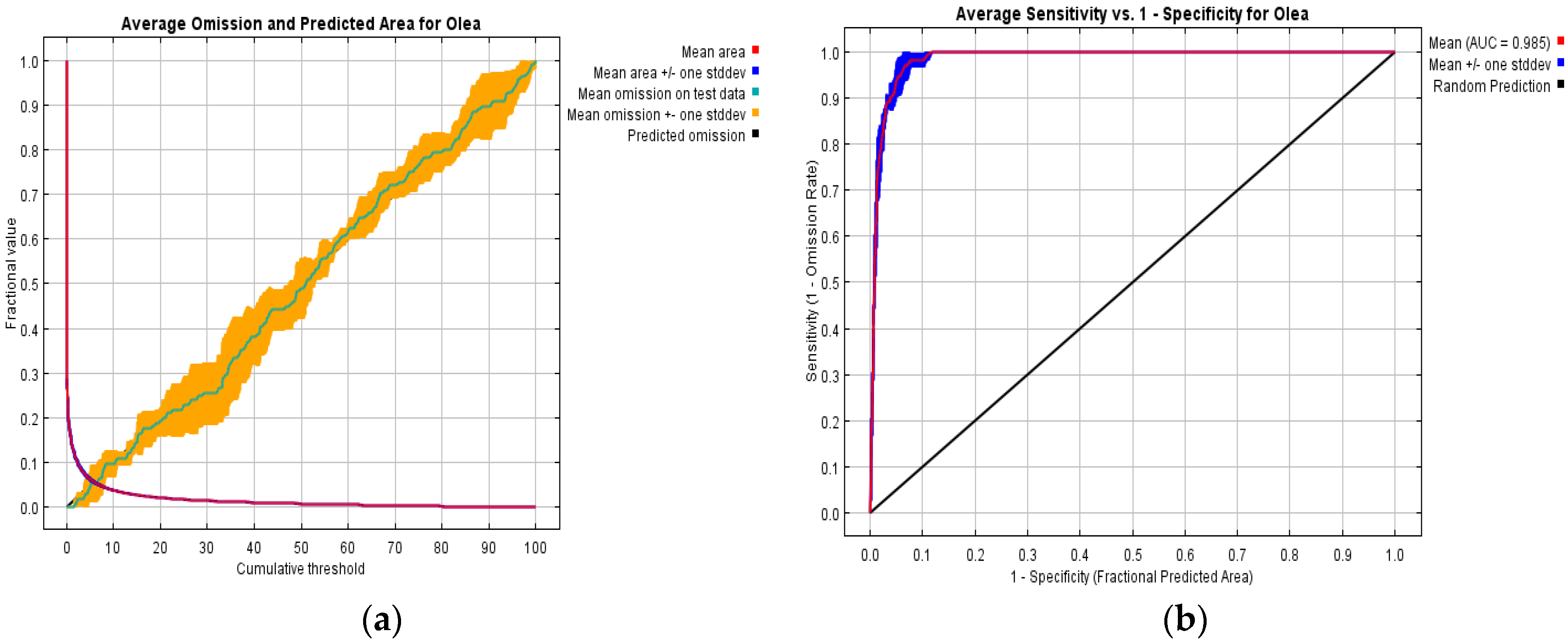
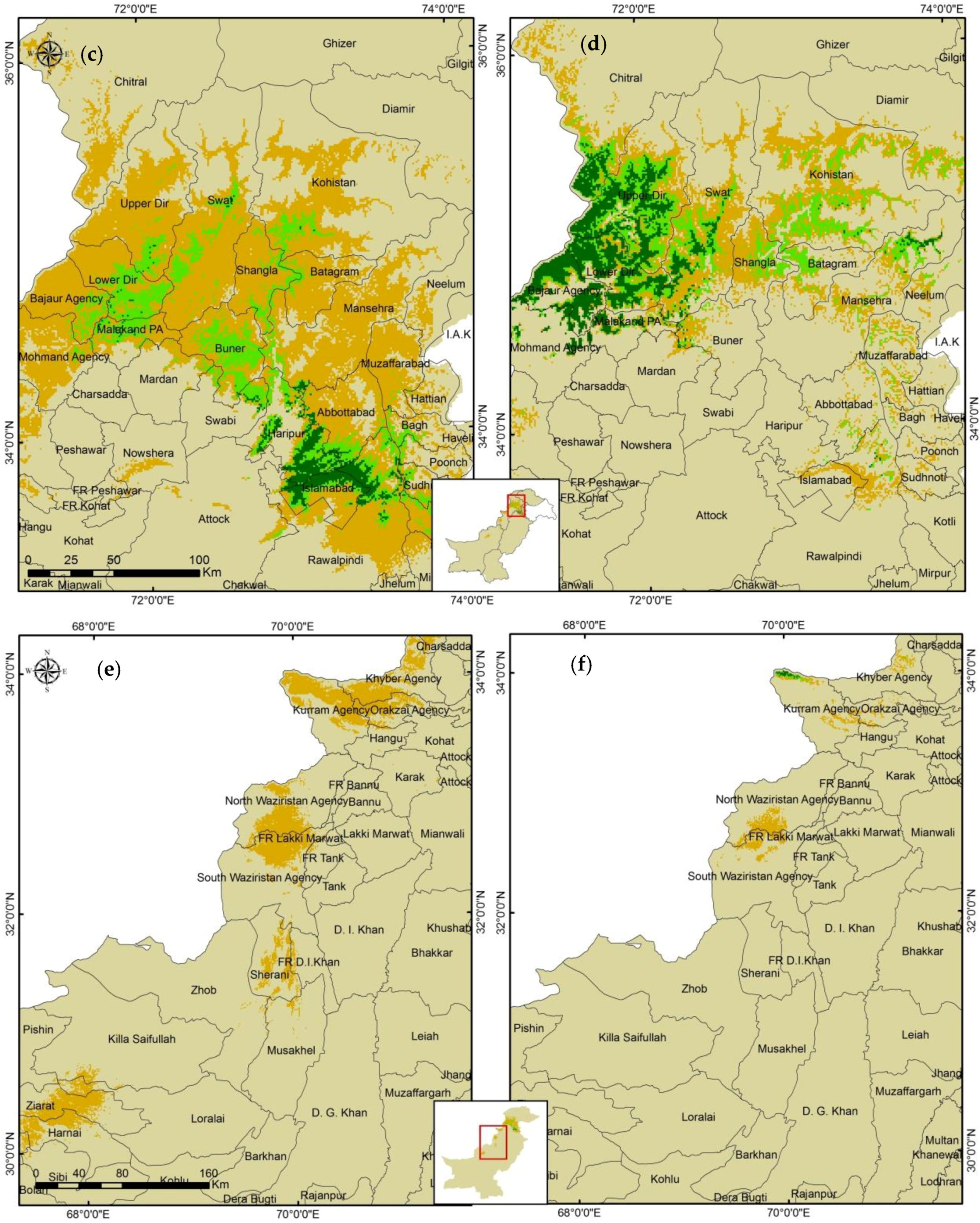
3. Results and Discussions
4. Conclusions
Author Contributions
Conflicts of Interest
Appendix

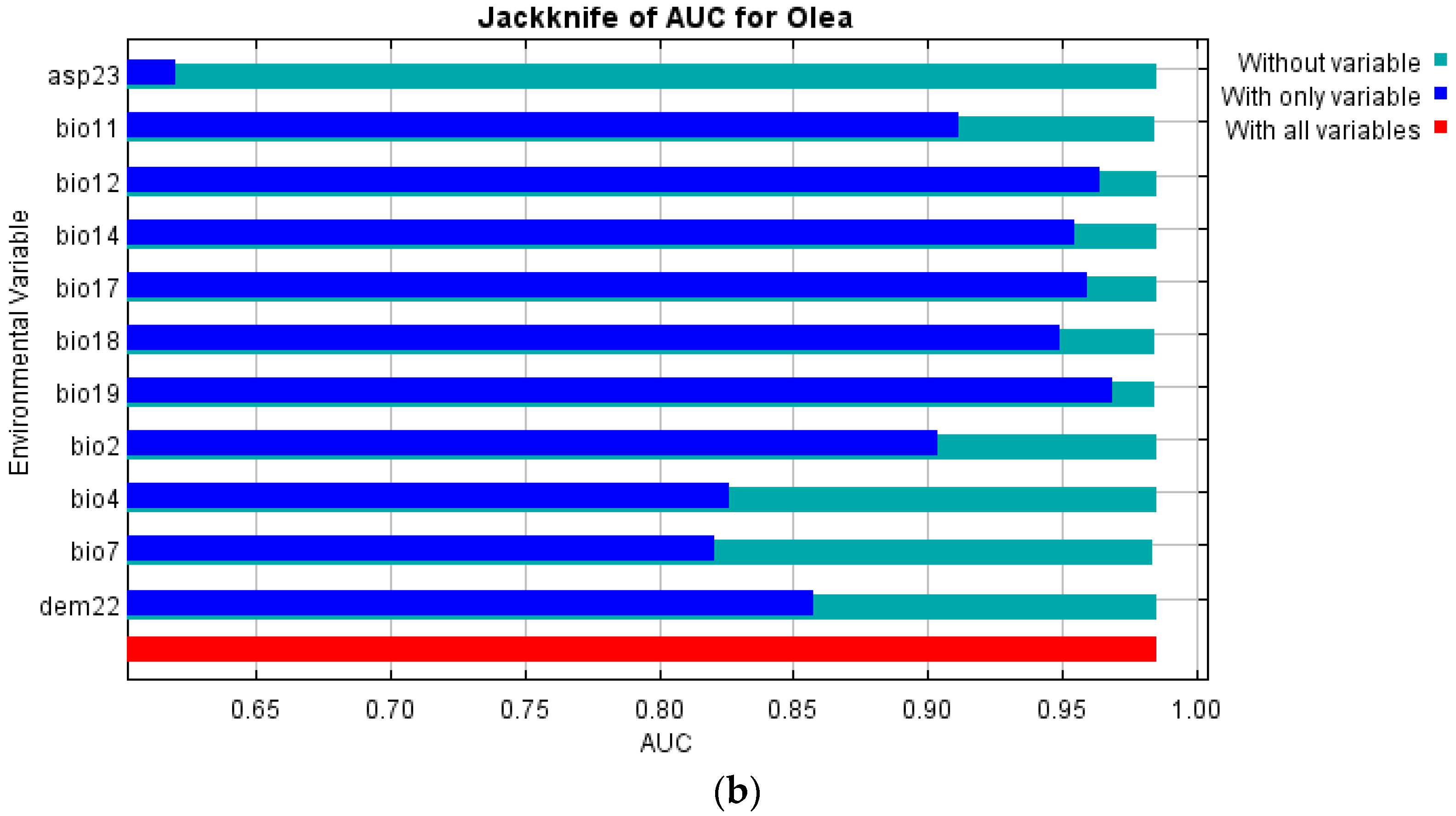
| Variable | Percent Contribution | Permutation Importance |
|---|---|---|
| bio12 | 38.6 | 4 |
| bio19 | 20.5 | 21.2 |
| bio17 | 12.3 | 0.1 |
| bio11 | 8 | 19.3 |
| bio18 | 6.1 | 39.1 |
| bio2 | 4.1 | 0.2 |
| bio14 | 3.2 | 6.6 |
| dem22 | 2.8 | 2.5 |
| bio7 | 2.5 | 4.4 |
| bio4 | 1.3 | 2.2 |
| asp23 | 0.5 | 0.4 |
References
- Zohary, D.; Spiegel-Roy, P. Beginning of fruit growing in the Old World. Science 1975, 187, 319–327. [Google Scholar] [CrossRef] [PubMed]
- Paudel, S. Current Status of Wild Olive (Olea cuspidata Wall.ex G. Don) in Bajura District of Nepal. Bachelor’s Thesis, Tribhuvan University, Kirtipur, Nepal, December 2001. [Google Scholar]
- Ahmed, M.; Khan, N.; Wahab, M.; Hamza, S.; Siddiqui, M.F.; Nazim, K.; Khan, M.U. Vegetation structure of olea ferruginea Royle forest of Lower Dir District of Pakistan. Pak. J. Bot. 2009, 41, 2683–2695. [Google Scholar]
- Khan, N.; Ahmed, M.; Wahab, M.; Ajaib, M.; Hussain, S.S. Studies along an altitudinal Gradient in Monotheca Buxifolia (Faloc.) A.D, Forest, District Lower Dir, Pakistan. Pak. J. Bot. 2010, 42, 3029–3038. [Google Scholar]
- Lennon, J.J.; Greenwood, J.J.B.; Turner, J.R.G. Bird Diversity and environmental gradients in Britian: A test of the species-energy hypothesis. J. Anim. Ecol. 2000, 69, 581–598. [Google Scholar] [CrossRef]
- Barbosa, A.M.; Real, R.; Olivero, J.; Vargas, J.M. Otter (Lutra lutra) distribution modelling at two resolution scales suited to conservation planning in the Iberian Peninsula. Biol. Conserv. 2003, 114, 377–387. [Google Scholar] [CrossRef]
- Phillips, S.J.; Anderson, R.P.; Schapire, R.E. Maximum entropy modeling of species geographic distributions. Ecol. Model. 2006, 190, 231–259. [Google Scholar] [CrossRef]
- Jeschke, J.; Strayer, D. Usefulness of bioclimatic models for studying climate change and invasive species. Ann. N. Y. Acad. Sci. 2008, 1134, 1–24. [Google Scholar] [CrossRef] [PubMed]
- Trisurat, Y.; Shrestha, R.P.; Kjelgren, R. Plant species vulnerability to climate change in Peninsular Thailand. Appl. Geogr. 2011, 31, 1106–1114. [Google Scholar] [CrossRef]
- Khan, N. A community analysis of Quercus baloot Griff, forest District Dir, Upper Pakistan. Afr. J. Plant Sci. 2012, 6, 21–31. [Google Scholar] [CrossRef]
- Ellis, C.J. Ancient woodland indicators signal the climate change risk for dispersal-limited species. Ecol. Indicat. 2015, 53, 106–114. [Google Scholar] [CrossRef]
- Slee, B.; Feliciano, D. Challenges in the design of indicators for assessing the impact of the Scotland Rural Development Programme 2007–2013 on climate change mitigation. Ecol. Indic. 2015, 59, 94–103. [Google Scholar] [CrossRef]
- Joly, P.; Morand, C.; Cohas, A. Habitat fragmentation and amphibian conservation: Building a tool for assessing landscape matrix connectivity. Comptes Rendus Biol. 2004, 4, 500–511. [Google Scholar] [CrossRef]
- Negga, H. Predictive modelling of amphibian distribution using ecological survey data: A case study of central Portuga. Master’s Thesis, International Institute for Geo-Information Science and Earth Observation, Enschede, The Netherlands, March 2007. [Google Scholar]
- Carpenter, G.; Gillson, A.N.; Winter, J. DOMAIN: A flexible modeling procedure for mapping potential distributions of plants and animals. Biodivers. Conserv. 1993, 2, 667–680. [Google Scholar] [CrossRef]
- Stockwell, D.R.B.; Peters, D.P. The GARP modelling system: Problems and solutions to automated spatial prediction. Int. J. Geogr. Inf. Syst. 1999, 13, 143–158. [Google Scholar] [CrossRef]
- Hirzel, A.H.; Hausser, J.; Chessel, D.; Perrin, N. Ecological-niche factor analysis: How to compute habitat-suitability map without absence data. Ecology 2002, 83, 2027–2036. [Google Scholar] [CrossRef]
- Pearson, R.G.; Dawson, T.P.; Berry, P.M.; Harrison, P.A. Species: A spatial evaluation of climate impact on the envelope of species. Ecol. Model. 2002, 154, 289–300. [Google Scholar] [CrossRef]
- Thuiller, W. Biomod—Optimizing predictions of species distributions and projecting potential future shifts under global change. Glob. Chang. Biol. 2003, 9, 1353–1362. [Google Scholar] [CrossRef]
- Elith, J.; Leathwick, J.R. Predicting species’ distributions from museum and herbarium records using multiresponse models fitted with multivariate adaptive regression splines. Divers. Distrib. 2007, 13, 165–175. [Google Scholar] [CrossRef]
- Franklin, J.; Davis, F.W.; Ikegami, M.; Syphard, A.D.; Flint, L.E.; Flint, A.L.; Hannah, L. Modeling plant species distributions under future climates: How fine scale do climate projections need to be? Glob. Chang. Biol. 2013, 19, 473–483. [Google Scholar] [CrossRef] [PubMed]
- Yu, J.; Wang, C.; Wan, J.; Han, S.; Wang, Q.; Nie, S. A model-based method to evaluate the ability of nature reserves to protect endangered tree species in the context of climate change. For. Ecol. Manag. 2014, 327, 48–54. [Google Scholar] [CrossRef]
- Moreno-Amat, E.; Mateo, R.G.; Nieto-Lugilde, D.; Morueta-Holme, N.; Svenning, J.C.; García-Amorena, I. Impact of model complexity on cross-temporal transferability in Maxent species distribution models: An assessment using paleobotanical data. Ecol. Model. 2015, 312, 308–317. [Google Scholar] [CrossRef]
- Pearson, R. Species Distribution Modeling for Conservation Educators and Practitioners. Available online: http://citeseerx.ist.psu.edu/viewdoc/download?doi=10.1.1.174.8844&rep=rep1&type=pdf#page=54 (accessed on 25 June 2016).
- Sillero, N. What does ecological modelling model? A proposed classification of ecological niche models based on their underlying methods. Ecol. Model. 2011, 222, 1343–1346. [Google Scholar] [CrossRef]
- Warren, D.L. In defense of ‘niche modeling’. Trends Ecol. Evol. 2012, 27, 497–500. [Google Scholar] [CrossRef] [PubMed]
- Guisan, A.; Thuiller, W. Predicting the species distribution: Offering more than simple habitat models. Ecol. Lett. 2005, 8, 993–1009. [Google Scholar] [CrossRef]
- Yost, A.N.; Petersen, S.L.; Gregg, M.; Miller, R. Predictive modeling and mapping sage grouse (Centrocercus urophasianus) nesting habitat using Maximum Entropy and a long-term dataset from Southern Oregon. Ecol. Inform. 2008, 3, 375–386. [Google Scholar] [CrossRef]
- Yuan, H.-S.; Wei, Y.-L.; Wang, X.-G. Maxent modeling for predicting the potential distribution of Sanghuang, an important group of medicinal fungi in China Fungal. Ecology 2015, 17, 140–145. [Google Scholar] [CrossRef]
- Cardona, J.N.; Loyola, R.D. Applying niche-based models to predict endangered-hylid potetial dsitributions: Are neotropical protected areas effective enough? Trop. Convers. Sci. 2008, 1, 417–445. [Google Scholar]
- Kgosiesele, E. Predictive Distribution Modelling of Timon lepida in Spain. Master’s Thesis, ITC, Enschede, The Netherlands, 2010. [Google Scholar]
- Yang, X.Q.; Kushwaha, S.P.S.; Saran, S.; Xu, J.; Roy, P.S. Maxent modeling for predicting the potential distribution of medicinal plant, Justicia adhatoda L. in Lesser Himalayan foothills. Ecol. Eng. 2013, 51, 83–87. [Google Scholar] [CrossRef]
- Khan, A.U.; Ahmad, F.; Sharif, F. Rapid Ranking Method for Prioritizing Restoration by Evaluating Human Influences on the Status of Scrub Forest: A Case Study. Pak. J. Bot. 2013, 45, 11–16. [Google Scholar]
- Ahmad, G. Mapping a Dry Shrub Forest for Biodiversity. Available online: https://www.itc.nl/library/Papers/msc_2001/Ghayyas_Ahmed.pdf (accessed on 28 July 2016).
- Sharma, R.K.; Sharma, N.; Samant, S.S.; Nandi, S.K.; Palni, L.M.S. Antioxidant Activities in Methanolic Extracts of Olea Ferruginea Royle Fruits. Int. J. Biosci. Biochem. Bioinform. 2013, 3, 154–156. [Google Scholar]
- Kumar, S.; Stohlgren, T.J. Maxent modeling for predicting suitable habitat for threatened and endangered tree Canacomyrica monticola in New Caledonia. J. Ecol. Nat. Environ. 2009, 1, 094–098. [Google Scholar]
- SRTM 90m Digital Elevation Database v4.1. Available online: http://www.cgiar-csi.org/data/srtm-90m-digital-elevation-database-v4-1 (accessed on 28 July 2016).
- Kaba, E.; Ginzler, O.; Ogilvie, J.; Pinner, L.; Patterson, D. ArcGIS Destop Help 9.2—Determining Aspect. 2007. Available online: http://webhelp.esri.com/arcgisdesktop/9.2/index.cfm?TopicName=Calculating_slope (accessed on 21 June 2013).
- Leyequien, E.; Verrelst, J.; Slot, M.; Schaepman-Strub, G.; Heitkonig, I.; Skidmore, A.K. Applying remote sensing to terrestrial animal distribution and diversity. Int. J. Appl. Earth Obs. Geoinfomation 2007, 9, 1–20. [Google Scholar] [CrossRef]
- Khanum, R.; Mumtaz, A.S.; Kumar, S. Prediciting impact of climate change on medicinal asclepiads of Pakistan using Maxent modeling. Acta Oecol. 2013, 49, 23–31. [Google Scholar] [CrossRef]
- WorldClim. Available online: www.worldclim.org (accessed on 28 July 2016).
- Shannon, C. A Mathematical Theory of Communication. Bell Syst. Tech. J. 1948, 27, 379–423. [Google Scholar] [CrossRef]
- Marquina, A. (Ed.) Environmental Challenges in the Mediterranean 2000–2050: Proceedings of the NATO Advanced Research Workshop on Environmental Challenges in the Mediterranean 2000–2050 Madrid, Spain 2–5 October 2002; Kluwer Academic Publishers: Dordrecht, the Netherlands, 2004; Volume 37.
- Papes, M.G. Modelling ecological niches from low numbers of occurrences: Assessment of the conservation status of poorly known viverrids (Mammalia, Carnivora) across two continents. Divers. Distrib. 2007, 13, 890–902. [Google Scholar] [CrossRef]
- Maxent Software for Species Habitat Modeling. Most Current Version: 3.3.3k. Available online: http://www.cs.princeton.edu/~schapire/maxent/ (accessed on 28 July 2016).
- Fielding, A.H.; Bell, J.F.L. A review of methods for the assessment of prediction errors in conservation presence/absence models. Environ. Conserv. 1997, 24, 38–49. [Google Scholar] [CrossRef]
- Van der Putten, W.H.; Macel, M.; Visser, M.E. Predicting species distribution and abundance responses to climate change: Why it is essential to include biotic interactions across trophic levels. Philosophical Transactions of the Royal Society of London B. Biol. Sci. 2010, 365, 2025–2034. [Google Scholar] [CrossRef] [PubMed]
- Chen, I.C.; Hill, J.K.; Ohlemüller, R.; Roy, D.B.; Thomas, C.D. Rapid range shifts of species associated with high levels of climate warming. Science 2011, 333, 1024–1026. [Google Scholar] [CrossRef] [PubMed]


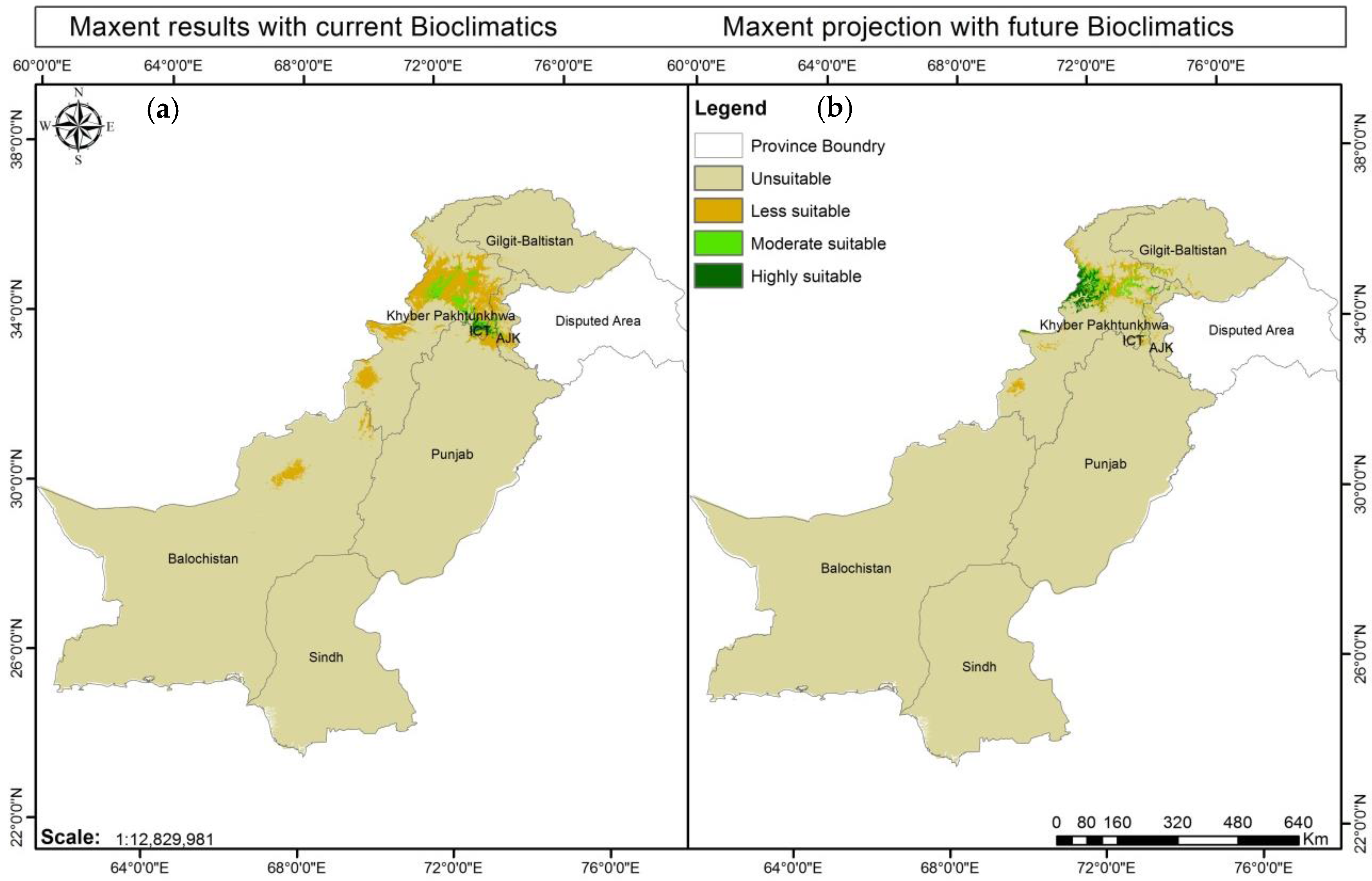

| Suitability | Threshold | Current Prediction (Km2) | Current Prediction (%) | Future Projection (Km2) | Future Projection (%) |
|---|---|---|---|---|---|
| Unsuitable area | <0.2 | 816169 | 95.16 | 838426 | 97.76 |
| Less suitable area | 0.2–0.4 | 35185 | 4.10 | 11098 | 1.29 |
| Moderately Suitable area | 0.4–0.6 | 4972 | 0.57 | 4361 | 0.50 |
| Highly Suitable area | >0.6 | 1292 | 0.15 | 3733 | 0.43 |
| Total Suitable area | 0.2–1.0 | 41449 | 4.83 | 19192 | 2.23 |
© 2016 by the authors; licensee MDPI, Basel, Switzerland. This article is an open access article distributed under the terms and conditions of the Creative Commons Attribution (CC-BY) license (http://creativecommons.org/licenses/by/4.0/).
Share and Cite
Ashraf, U.; Ali, H.; Chaudry, M.N.; Ashraf, I.; Batool, A.; Saqib, Z. Predicting the Potential Distribution of Olea ferruginea in Pakistan incorporating Climate Change by Using Maxent Model. Sustainability 2016, 8, 722. https://doi.org/10.3390/su8080722
Ashraf U, Ali H, Chaudry MN, Ashraf I, Batool A, Saqib Z. Predicting the Potential Distribution of Olea ferruginea in Pakistan incorporating Climate Change by Using Maxent Model. Sustainability. 2016; 8(8):722. https://doi.org/10.3390/su8080722
Chicago/Turabian StyleAshraf, Uzma, Hassan Ali, Muhammad Nawaz Chaudry, Irfan Ashraf, Adila Batool, and Zafeer Saqib. 2016. "Predicting the Potential Distribution of Olea ferruginea in Pakistan incorporating Climate Change by Using Maxent Model" Sustainability 8, no. 8: 722. https://doi.org/10.3390/su8080722