Communication

New Insights into the Geography and Modelling of Wind Erosion in the European Agricultural Land. Application of a Spatially Explicit Indicator of Land Susceptibility to Wind Erosion

European Commission, Joint Research Centre, Institute for Environment and Sustainability, Via E. Fermi 2749, Ispra (VA) I-21027, Italy
*
Author to whom correspondence should be addressed.
Sustainability 2015, 7(7), 8823-8836; https://doi.org/10.3390/su7078823
Submission received: 9 June 2015 / Revised: 28 June 2015 / Accepted: 29 June 2015 / Published: 7 July 2015
(This article belongs to the Section Environmental Sustainability and Applications)

Abstract

:
The current state of the art in erosion research does not provide answers about the “where” and “when” of wind erosion in European agricultural lands. Questions about the implications for the agricultural productivity remain unanswered. Tackling this research gap, the study provides a more comprehensive understanding of the spatial patterns of land susceptibility to wind erosion in European agricultural lands. The Index of Land Susceptibility to Wind Erosion (ILSWE) was applied in a GIS environment. A harmonized input dataset ranked following a fuzzy logic technique was employed. Within the 36 European countries under investigation, moderate (17.3 million ha) and high levels (8.8 million ha) of land susceptibility to wind erosion were predicted. This corresponds to 8.0% and 4.1% of total agricultural land, respectively.

Graphical Abstract

1. Introduction

Soil erosion by wind is a serious environmental threat [1] that causes severe soil degradation in arid, semi-arid, and agricultural areas [2,3]. It implies a loss of the finest and most biologically active part of the soil layer which is rich in organic matter and nutrients [4]. The transport of soil occurs when forces exerted by wind overcome the gravitational and cohesive forces of soil particles on the surface of the ground [5] and when the surface is mostly devoid of vegetation, stones, and/or snow [6]. These conditions are more likely in arid regions. Still, wind erosion is not restricted to these areas [7].
In Europe, wind erosion is a well-known threat in many parts of Northern Germany, the Eastern Netherlands, Eastern England, and the Iberian Peninsula [8,9,10,11,12,13] among others. Estimates of the extent of wind erosion range from 10 to 42 million ha of Europe’s total land area, with around 1 million ha being categorized as severely affected [1,14,15]. The results of recent studies, however, indicate that few details are known about the magnitude of wind erosion in Europe [16]. The aforementioned numbers, derived from dated literature, may not deliver an up-to-data realistic picture of this environmental threat [17,18]. Recent studies, conducted at a European scale, to assess the soils’ susceptibility to wind erosion [19] and the land susceptibility to wind erosion [20] have provided important insights into the spatial variability of the susceptibility of land to wind erosion across Europe.
The innovative objectives of this communication are (i) to integrate the study of Borrelli et al. [20] providing spatially explicit information about the wind erosion susceptibility of agricultural lands in Europe; and (ii) to present the downscaling ability of the proposed modeling approach to deal with the scale-dependency of wind erosion [6]. The focus is set on identifying regions that suffer from high susceptibility to wind erosion, where inappropriate agricultural land management practices may further accelerate wind erosion rates, e.g., unprotected fallow lands, overgrazed rangeland pastures and, to a lesser extent, over-harvested vegetation, intensive crop cultivation, increased mechanisation, increased field sizes, and removal of hedges [4,21,22].

2. Material and Methods

2.1. Study Area

The study area includes the agricultural area of the 28 Member States of the European Union (EU-28), the three European Union candidate countries (Montenegro, Serbia, Former Yugoslav Republic of Macedonia), the three potential European Union candidate countries (Albania, Bosnia and Herzegovina, Kosovo), Norway and Switzerland. The study area covers about 2.15 million km2, corresponding to all the agricultural units of the CORINE land cover 2006 database [23], i.e., arable land (114.50 × 10⁶ ha, 53.1%), heterogeneous agricultural land (52.8 × 10⁶ ha, 24.5%), pastures (37.80 × 10⁶ ha, 17.5%) and permanent crops (10.44 × 10⁶ ha, 4.9%).

2.2. The Index of Land Susceptibility to Wind Erosion—ILSWE

Wind erosion is a complex geomorphic process that involves multiple variables [6] which makes it difficult to comprehensively parameterize this set of variables for large scale studies [4]. The most advanced field-scaled models (Wind Erosion Prediction System [22], among others) are too complex to be adequately upscaled for this purpose. Pan-European studies thus call for a complexity reduction [4,24] yet keeping the key factors that express the complex interactions between the wind erosion variables [20]. The ILSWE follows the well-established concept according to which wind erosion occurs when three conditions are met: (1) the wind is strong enough; (2) the soil surface is susceptible; and (3) there is no or little surface protection by crops, residues or snow [25]. In the light of the above, the extent of an erosive event is governed by the eroding capacity of the wind and the inherent potential of the land to be eroded [26]. The pan-European assessment described in this paper is based on the integration of the most influential parameters, i.e., climate (wind, rainfall, evaporation), soil characteristics (sand, silt, clay, CaCO3, organic matter, water-retention capacity, soil moisture) and land use (land use, percent of vegetation cover, landscape roughness). The spatial and temporal variability of these factors is appropriately defined through Geographic Information System (GIS) analyses. Harmonized datasets and a unified methodology were employed to suit the pan-European scale and to avoid misleading findings that could have resulted from heterogeneous input data. Conceptually, the selected soil erosion parameters were divided into three groups: (i) climate erosivity; (ii) soil erodibility; and (iii) vegetation cover and landscape roughness.
Climate Erosivity: The influence of the climate on the wind erosion process depends not only on the wind speed but also on the soil moisture conditions. Accordingly, a simplified topsoil moisture model was used to predict the daily water content in the uppermost soil layer (5 cm) of European soils:
W t =   W t 1 + P E T   , forced in the interval  ( 0 , AWC )
where Wt is the potential daily soil moisture content in the first 5 cm of the topsoil layer , Wt−1 is the potential daily soil moisture content of the previous day, P is the daily precipitation, ET is the daily Penman potential evapotranspiration and AWC is the available water capacity of soil. Daily time-series of climate data (25 × 25 km cell size) were provided by the JRC’s Monitoring Agriculture Resources Unit (covering the period 1981–2010). Days showing high soil moisture content (>7%) were filtered out from the computation of the wind force (WF) [26]. Finally, the monthly wind force (WFm) was computed as:
W F m   = α   = 1 s ( U   ( U   U t ) 2 )   α
where WFm is the monthly wind force for erosive days α, and s is the number of erosive days in a month period, U is the average daily wind speed and Ut is the threshold wind speed set to 7 m·s−1.
Soil erodibility: It represents the susceptibility of soil to erosion and was assessed [19] by using the multiple regression equation proposed by Fryrear et al. [26] to predict the wind-erodible fraction of soils based on their texture and chemical properties:
E F =   29.09 + 0.31   S a + 0.17   S i + 0.33 S c 2.59   O M 0.95   C a C O 3 100
where all variables are expressed as percentages. Sa is the soil sand content, Si is the soil silt content, Sc represents the ratio of sand to clay contents, OM is the organic matter content, and CaCO3 is the calcium carbonate content.
Vegetation cover and landscape roughness: This module deals with the different status of vegetation and landscape conditions affecting the wind erosion process by dissipating the wind erosivity and providing an efficient shelter effect. The ENVISAT/MERIS satellite images were adopted to describe the monthly vegetation cover (Leaf Area Index, LAI) and bare soil conditions (Fraction of Soil, FSoil) [27]. To represent the potential effect of land use on wind energy, the aerodynamic roughness length in Europe ( z 0 in m) was estimated on the basis of Corine land cover 2006 data and the TA-LUFT [28] roughness classification [4].
The sensitivity of the contribution factor groups was ensured using a fuzzy logic technique [29]. This technique allows for an unambiguous definition of the sensitivity range of each factor in Europe [30]. The sensitivity ranges and threshold values of the input factors were ranked according to the relationships defined in literature and derived by field experiments. The functions used to reclassify the factors were (i) linear for the Climate Erosivity (WFm); (ii) linear for the Soil Erodibility (EF); (iii) half-hyperbolic for the Vegetation Cover (VCm); and (iv) logarithmic for the Land Roughness (LR). Monthly Index of Land Susceptibility to Wind Erosion values (ILSWEM) were computed using a multiplicative equation (Equation (4)) and aggregated in the annual ILSWE (Equation (5)):
I L S W E M =   W F M E F V C M L R
I L S W E = j = 1 J = 12 ( I L S W E M )   j
According to Equation (4), the land susceptibility to wind erosion is the result of the multiplication of the wind erosion driving force (WFM) for three decreasing factors (EF, VCM, LR). Further details about the methodology are given in Borrelli et al. [20].

3. Results and Discussion

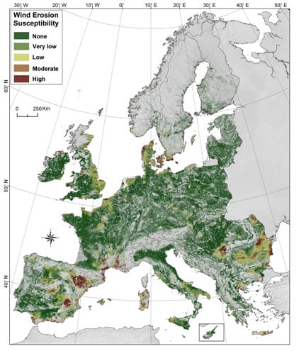
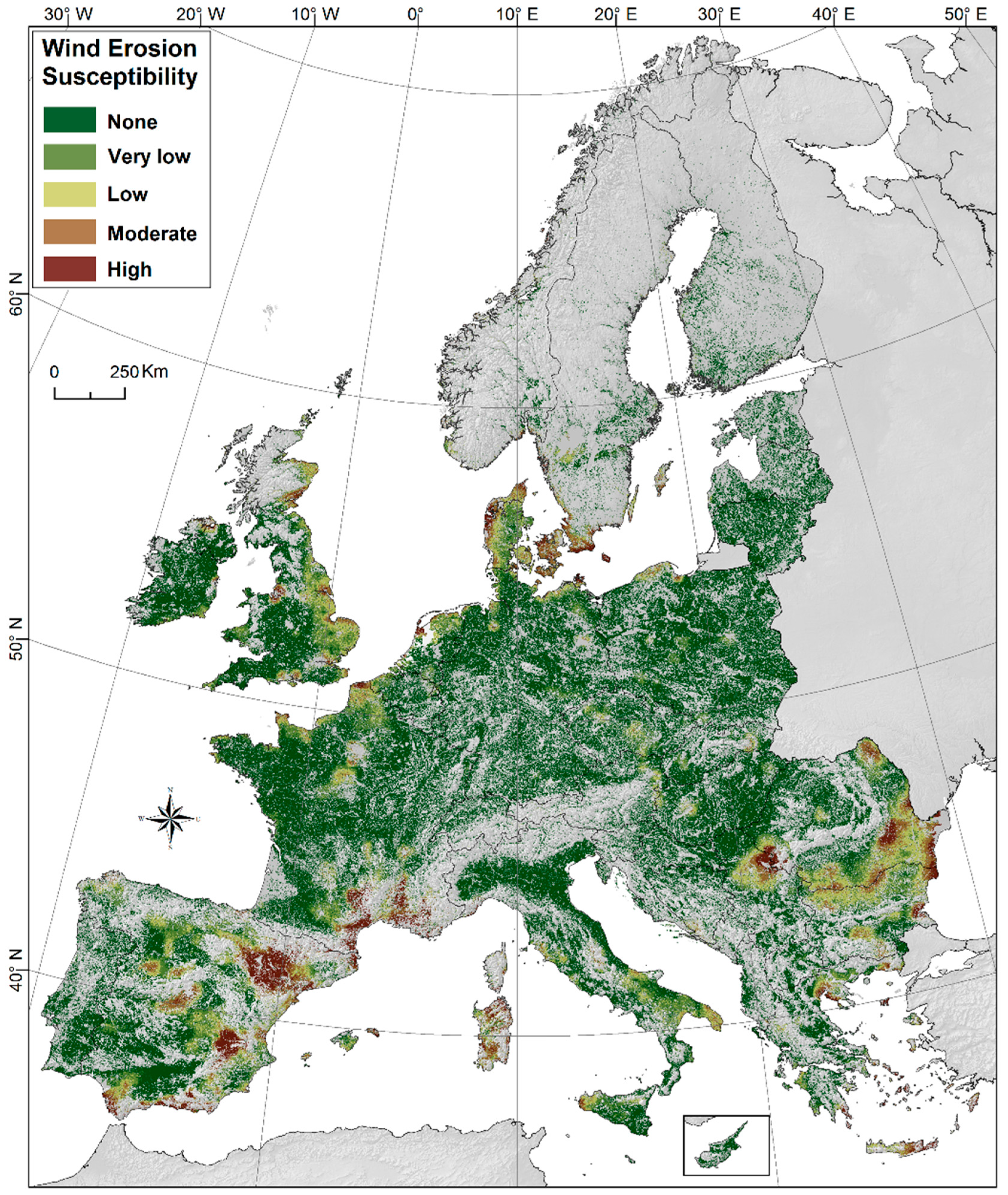
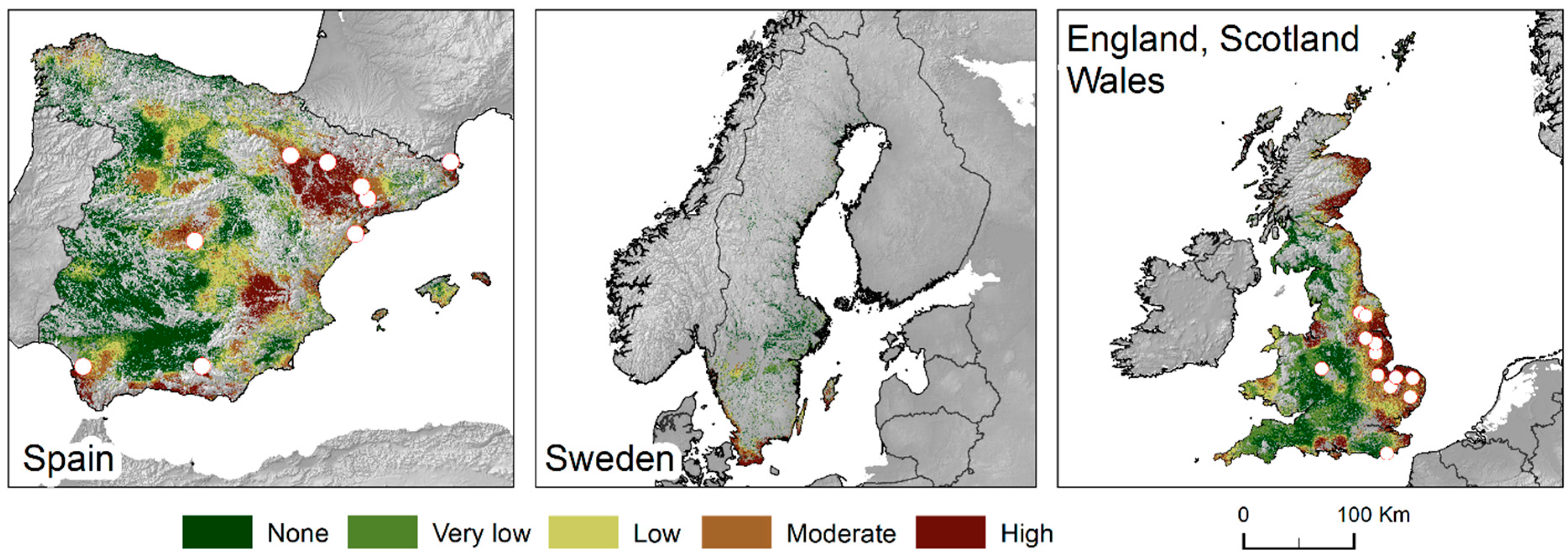
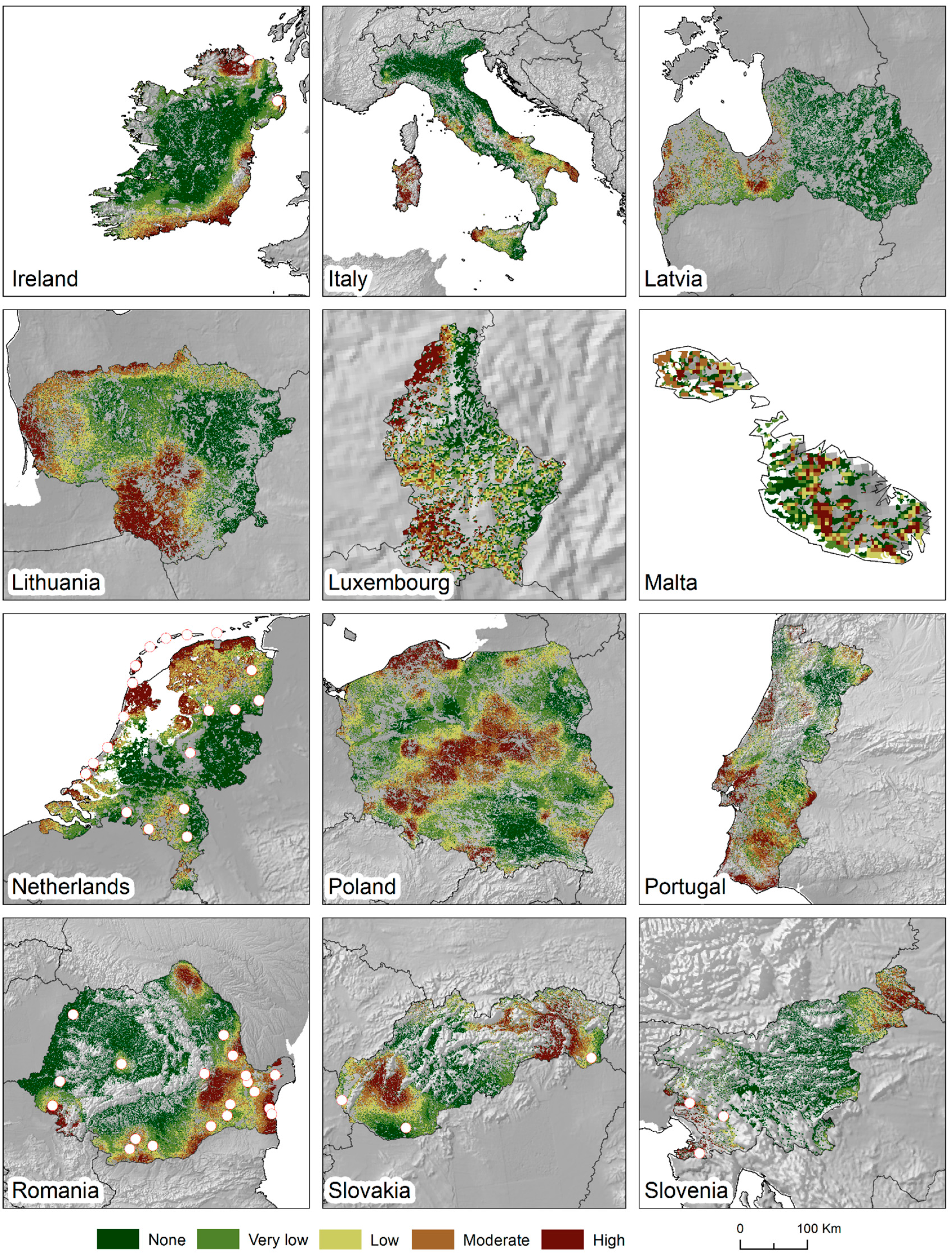
3.1. Agricultural Land Susceptibility to Wind Erosion

The Index of Land Susceptibility to Wind Erosion (ILSWE) to subdivide the surface of the 36 European countries was estimated based on a 215.1 million cells format (100 m spatial resolution derived by Corine subsetting of the 500 m original format). Figure 1 shows the ILSWE outcomes using daily climate data for the period from 1981 to 2010 and the land cover condition of 2012. The modelling results were ranked into five classes using quintiles as a classification method. Approximately 68.4% of the land surface under investigation showed no susceptibility to wind erosion. The portion of the studied area with low and very low susceptibility accounted for 19.5%, whereas moderate susceptibility was reported for 8% of the area (ca. 17.3 million ha). The remaining 4.1% (ca. 8.8 million ha) of the study area showed high land susceptibility to wind erosion.
The modeling results illustrate that the vast majority of the agricultural area shows none or very low susceptibility to wind erosion. Agricultural areas potentially affected by moderate to high erosion levels can be found in specific regions. The disclosure of highly susceptible agricultural regions in Northern Europe confirm the findings previously reported in literature. The Swedish Scania region is the area with the highest susceptibility [10]. The Danish islands and large sectors on the Northwest Danish coasts also show high susceptibility [31]. Other highly susceptible regions are found along the coastal area, such as in North Holland and Friesland in the Netherlands [8], Mecklenburg-Western Pomerania, Lower Saxony and Schleswig-Holstein in Germany [7,17], Eastern and Southern England [16], Nord-Pas-de-Calais and Normandy in France, and Pomeranian Voivodeship in Poland. Some hotspots of moderate to high susceptibility were identified in the inner regions, like Centre-Val de Loire in France. It seems that soil erosion by wind, by contrast, is not a significant environmental threat for the Eastern Baltic states and large parts of Finland and Ireland. In the Mediterranean area, the susceptibility is high to moderate along the South-west coast of Spain which shows large sectors of agricultural lands potentially affected by wind erosion (i.e., Andalucía, Castilla-La Mancha, Aragón, Cataluña and some hotspots located in the Inner Peninsula) [9,18], in the Gulf of Lion and on the Italian (Sardinia and Western Sicily) and Greek islands (mostly Crete and Cyclades Islands). Severe susceptibility was modelled for sizable regions along the Romanian and Bulgarian coasts and in the lowlands surrounding the Carpathian Mountains.
Figure 1. Index of Land Susceptibility to Wind Erosion (ILSWE) predicted for the agricultural land of 36 European countries.
Sustainability 07 08823 g001
Considering the bio-geographical regions, the results reveal that the Black Sea bio-geographical region shows average annual land susceptibility values (Table 1). It is followed by the Steppic, Mediterranean and Arctic.
Table 1. Average annual land susceptibility aggregated per biogeographical region.
Bio-Geographical RegionLand Susceptibility to Wind Erosion
NameSurface (%)NoneVery LowLowModerateHigh
(%)
Alpine3.388.75.23.81.60.7
Arctic0.0472.43.38.99.95.5
Black Sea0.29.10.75.516.268.5
Continental38.577.67.27.26.21.7
Mediterranean21.347.412.516.412.411.3
Pannonian5.280.47.45.24.12.8
Steppic1.45.72.719.652.319.7
Atlantic23.264.511.614.47.81.6
Boreal7.091.53.32.72.10.4
Descriptive statistics of the proposed index for the 36 European countries are provided in Table 2. The agricultural lands with the highest land susceptibility to wind erosion (moderate and high susceptibility) are Denmark (1.82 million ha; 56.2% of the land area), Bulgaria (1.86 million ha; 32.3%), Romania (1.14 million ha; 30.1%), Spain (3.33 million ha; 27%) and to a lesser extent Sweden (0.36 million ha; 23.8%), Greece (1.11 million ha; 21.4%) and Serbia and Kosovo (0.3 million ha; 19.9%). None to very low susceptibility to wind erosion is detected for Cyprus, Luxembourg and Malta. Here, the observed geomorphological process appears to be a less prominent environmental threat.
Table 2. Descriptive statistics of the agricultural land susceptibility to wind erosion for European countries.
CountryLand Susceptibility to Wind Erosion
NoneVery LowLowModerateHigh
(%)
Albania96.82.10.40.50.0
Austria82.57.07.82.70.0
Belgium78.27.410.83.60.0
Bosnia and Herzegovina93.42.11.72.80.0
Bulgaria29.811.126.827.05.3
Cyprus1000.00.00.00.0
Croatia95.52.81.50.20.0
Czech Republic67.618.611.22.50.0
Denmark6.17.630.137.818.3
Estonia98.21.70.10.00.0
Finland91.84.43.00.80.0
Former Yugoslav Rep. Macedonia84.711.93.40.00.0
France71.010.69.15.24.0
Germany88.75.83.71.50.2
Greece53.210.415.112.29.2
Hungary87.87.43.71.10.0
Ireland85.27.34.62.20.6
Italy65.111.612.67.73.0
Latvia98.41.00.30.20.0
Liechtenstein1000.00.00.00.0
Lithuania1000.00.00.00.0
Luxembourg1000.00.00.00.0
Malta1000.00.00.00.0
Montenegro86.59.24.40.00.0
Netherlands48.314.624.39.43.4
Norway64.97.711.911.04.5
Poland89.67.02.30.90.1
Portugal97.32.30.30.00.0
Romania47.47.415.021.78.4
Serbia and Kosovo64.16.69.313.86.1
Slovakia78.511.17.42.90.1
Slovenia99.80.10.00.00.0
Spain39.713.919.514.013.0
Sweden59.57.88.914.69.2
Switzerland98.50.90.50.10.0
United Kingdom53.211.720.112.52.4
The modelling outcomes presented in Figure 1 were ranked into five classes using quintiles as a classification method. Note that risk and susceptibility are relative concepts (also scale-dependent). Therefore, the susceptibility of the subdimensions of the study area can been further classified according to the new index range. Figure 2 shows the reclassification of the ILSWE for Germany. The results are consistent with local studies and literature [32,33,34,35]. Although the German areas outlined have a relevant susceptibility to wind erosion and potentially high risk compared to the rest of Germany, at a European scale, relatively seen, they appear less significant (e.g., compared to some Danish and Spanish regions, Scania or the Greek islands). To resolve this issue, ILSWE is dynamic and can be downscaled to the area of interest, thereby providing an assessment of land susceptibility to wind at multiple scales. Figure 3 shows the reclassification of the ILSWE for the other 27 EU countries.

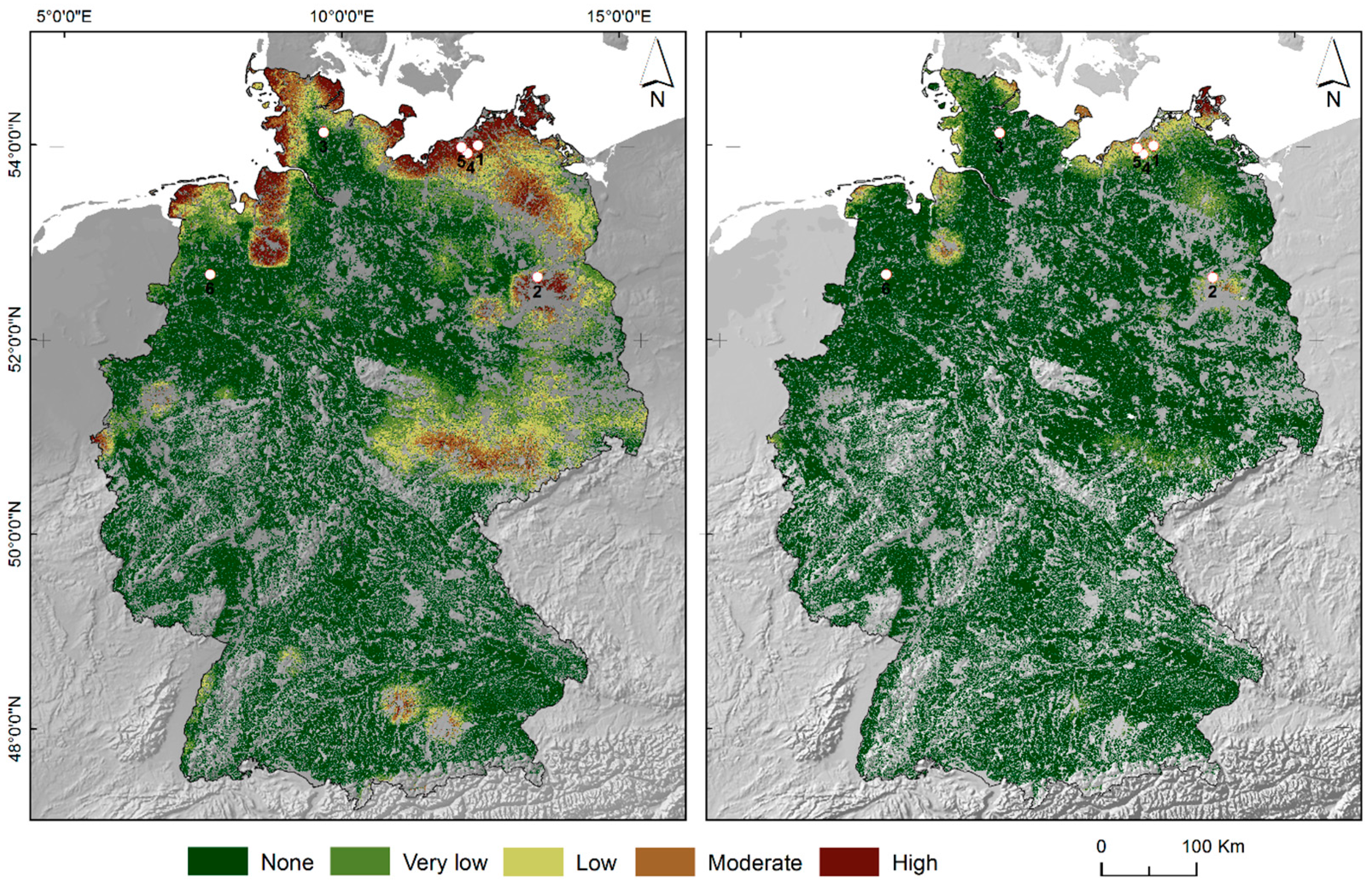
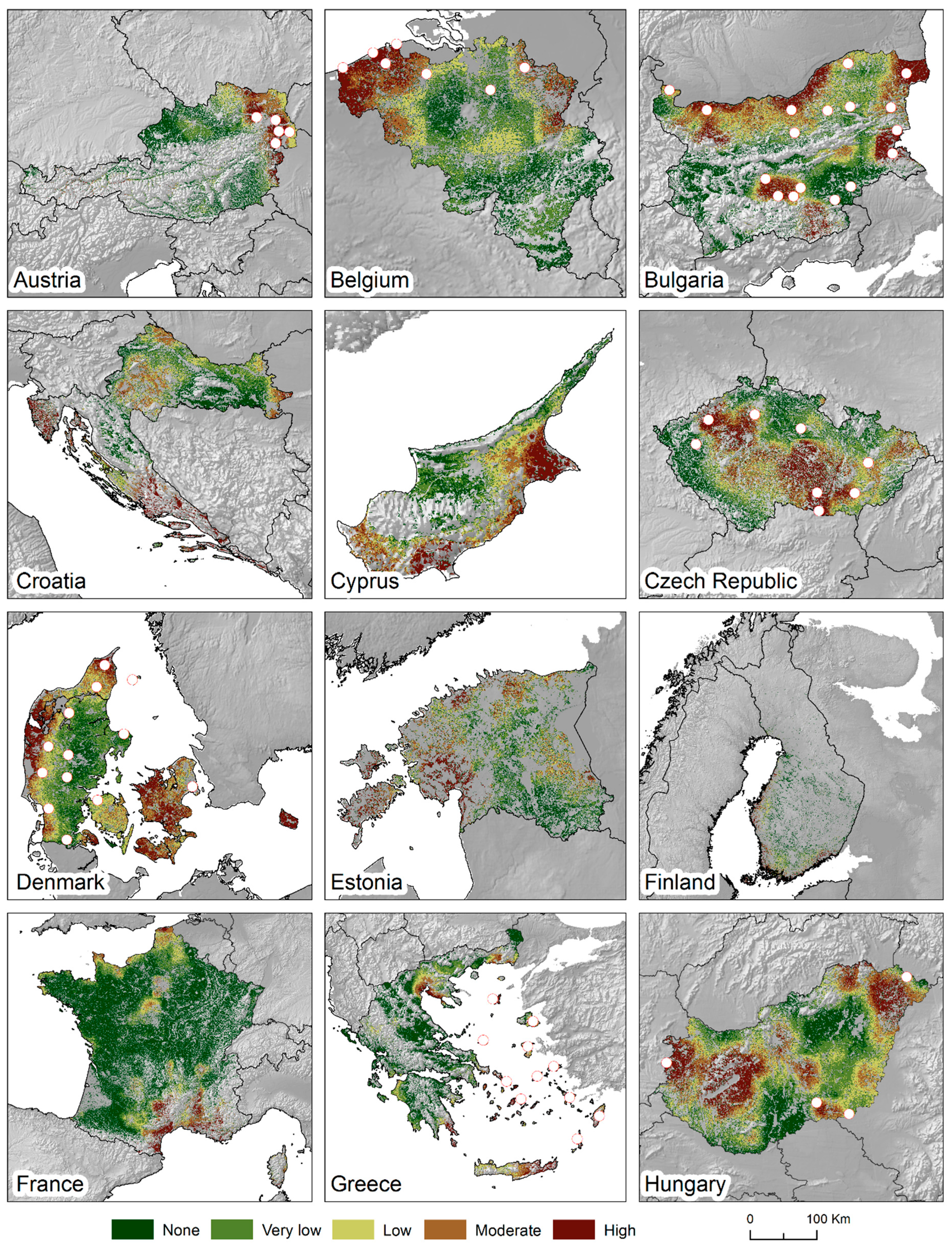
3.2. Model Evaluation

Regarding the model performance, the validation procedure revealed that the areas that were predicted as susceptible to wind erosion coincided with the reference locations reported in the literature. The overall accuracy was 95.5% with a Kappa Index of Agreement (KIA) of 0.910. Accordingly, 109 (69.7%) of the 156 locations reported in literature were classified as being moderately/highly susceptible while another 13 (8.4%) fell into areas defined as having low susceptibility. Another 27 (17.4%) of the literature sites fell into areas classified as being very lowly susceptible.
Figure 2. Comparison of the predicted land susceptibility to wind erosion in German agricultural lands classified according to the German (left) and European (right) index range. The white points indicate locations described in the literature as being affected by wind erosion (point 1, [33]; point 2, [32]; points 3–5 [35]; point 6, [34]).
Sustainability 07 08823 g002
Figure 3. ILSWE modelling outcomes for each EU country ranked into five classes using quintiles as a classification method. The white points indicate locations described in the literature as being affected by wind erosion [20].
Sustainability 07 08823 g003aSustainability 07 08823 g003bSustainability 07 08823 g003c

3.3. Data Availability

The European map of agricultural land susceptibility to wind erosion is available on the European Soil Data Centre (ESDAC) web platform [36]. It can be downloaded free of charge in GeoTIFF raster format [37] to encourage further regional and pan-European investigations into the spatial variability of agricultural land susceptibility to wind erosion.

4. Conclusions

The state of the art in erosion research lacked knowledge about the “where” and “when” of wind erosion in European agricultural lands, and its productivity implications [11]. This lack constituted a major obstacle that restricted national and European institutions from taking actions aimed at an effective mitigating of the resulting land degradation. The elaboration of daily climate data, LUCAS-Topsoil data satellite imagery and land use information combined with a digital soil mapping and Geographical Information System techniques allowed for the creation of the first map of agricultural land susceptibility to wind erosion at a European scale to close the described gap. The outcomes of the current study constitute an important step towards a better understanding of the spatial (“where”) and temporal (“when”) patterns in land susceptibility to wind erosion in the European agricultural land. These insights are essential to design effective management strategies in order to control the land degradation. The proposed Index of Land Susceptibility to Wind Erosion (ILSWE) carries spatially explicit information about the observed geomorphological process. New insights into the geography of wind erosion susceptibility in European agricultural areas are obtained. This provides a solid basis for further investigations into the spatial variability and susceptibility of land to wind erosion in Europe. The index indicates that, although the areas along the Northern Sea coasts show high susceptibility to erosion (phenomenon largely described by the cited literature), wind erosion seems to be a greater problem for the Southern European countries. Alarming wind erosion susceptibility values were observed in several locations throughout Mediterranean Europe. This calls for a new phase of field measurements and local monitoring operations that are adequately distributed across Europe.

Acknowledgments

The authors are grateful to JRC’s Monitoring Agriculture Resources Unit (MARS) who have donated the climate data. The authors also wish to thank the Copernicus project and the European Space Agency for providing the satellite imagery.

Author Contributions

The authors belong to the Resource Soil Assessment group of the European Commission Joint Research Centre, which conducts research on soil-related topics. All the authors have cooperated for the design, development, and preparation of this work and all have read and approved the final manuscript. All authors have read and approved the final manuscript.

Conflicts of Interest

The authors declare no conflict of interest.

References

  1. Lal, R. Soil erosion by wind and water: Problems and prospects. Soil Eros. Res. Methods 1994, 2, 1–9. [Google Scholar]
  2. Woodruff, N.P.; Siddoway, F.H. A wind erosion equation. Soil Sci. Soc. Am. J. 1965, 29, 602–608. [Google Scholar] [CrossRef]
  3. Kalma, J.D.; Speight, J.G.; Wasson, R.J. Potential wind erosion in Australia: A continental perspective. J. Climatol. 1988, 8, 411–428. [Google Scholar] [CrossRef]
  4. Funk, R.; Reuter, H.I. Wind erosion. In Soil Erosion in Europe; Boardman, J., Poesen, J., Eds.; Wiley: Chichester, UK, 2006; pp. 563–582. [Google Scholar]
  5. Bagnold, R.A. The Physics of Blown Sand and Desert Dunes; Methuen and Company: London, UK, 1941. [Google Scholar]
  6. Shao, Y. Physics and Modelling of Wind Erosion; Springer: Cologne, Germany, 2008. [Google Scholar]
  7. Funk, R.; Skidmore, E.L.; Hagen, L.J. Comparsion of wind erosion measurements in Germany with simulated soil losses by WEPS. In Proceedings of the ICAR5/GCTE-SEN Joint Conference, Lubbock, TA, USA, 22–25 July 2002; pp. 235–238.
  8. Eppink, L.A.A.J.; Spaan, W.P. Agricultural wind erosion control measures in The Netherlands. Soil Technol. Ser. 1989, 1, 1–13. [Google Scholar]
  9. López, M.V.; Sabre, M.; Gracia, R.; Arrue, J.L.; Gomes, L. Tillage effects on soil surface conditions and dust emission by wind erosion in semiarid Aragon (NE Spain). Soil Tillage Res. 1998, 45, 91–105. [Google Scholar] [CrossRef]
  10. Bärring, L.; Jönsson, P.; Mattsson, J.O.; Åhman, R. Wind erosion on arable land in Scania, Sweden and the relation to the wind climate—A review. Catena 2003, 52, 173–190. [Google Scholar] [CrossRef]
  11. Warren, A. Wind Erosion on Agricultural Land in Europe: Research Results for Land Managers; Office for Official Publications of the European Communities: Bruxelles, Belgium, 2003. [Google Scholar]
  12. Martínez-Graña, A.M.; Goy, J.L.; Zazo, C. Water and Wind Erosion Risk in Natural Parks—A Case Study in “Las Batuecas-Sierra de Francia” and “Quilamas” Protected Parks (Central System, Spain). Int. J. Environ. Res. 2014, 8, 61–68. [Google Scholar]
  13. Martínez-Graña, A.M.; Goy, J.L.; Zazo, C. Cartographic procedure for the analysis of aeolian erosion hazard in natural parks (Central System, Spain). Land Degrad. Dev. 2015, 26, 110–117. [Google Scholar] [CrossRef]
  14. European Environment Agency (EEA). Europe’s Environment: The Second Assessment; Elsevier: London, UK, 1998. [Google Scholar]
  15. European Environment Agency (EEA). The Third Assessment. Environmental Assessment; Report No 10; European Environment Agency: Copenhagen, Denmark, 2003. [Google Scholar]
  16. Chappell, A.; Warren, A. Spatial scales of 137Cs-derived soil flux by wind in a 25 km2 arable area of eastern England. Catena 2003, 52, 209–234. [Google Scholar] [CrossRef]
  17. Böhner, J.; Schäfer, W.; Conrad, O.; Gross, J.; Ringeler, A. The WEELS model: Methods, results and limitations. Catena 2003, 52, 289–308. [Google Scholar] [CrossRef]
  18. Gomes, L.; Arrue, J.L.; Lopez, M.V.; Sterk, G.; Richard, D.; Gracia, R.; Frangi, J.P. Wind erosion in a semiarid agricultural area of Spain: The WELSONS project. Catena 2003, 52, 235–256. [Google Scholar] [CrossRef]
  19. Borrelli, P.; Ballabio, C.; Panagos, P.; Montanarella, L. Wind erosion susceptibility of European soils. Geoderma 2014, 232, 471–478. [Google Scholar] [CrossRef]
  20. Borrelli, P.; Panagos, P.; Ballabio, C.; Lugato, E.; Weynants, M.; Montanarella, L. Towards a pan-European assessment of land susceptibility to wind erosion. Land Degrad. Dev. 2014. [Google Scholar] [CrossRef]
  21. Leys, J.F. Wind Erosion on Agricultural Land. In Aeolian Environments, Sediments and Landforms; Goudie, A.S., Livingstone, I., Eds.; Wiley: Chichester, UK, 1999; pp. 143–166. [Google Scholar]
  22. Wagner, L.E. An overview of the wind erosion prediction system. Available online: https://webdisk.ucalgary.ca/~walkerd/public_html/Wind%20Erosion%20Prediction/WEPS_Overview.pdf (accessed on 30 June 2015).
  23. European Environment Agency (EEA). Assessment and Reporting on Soil Erosion; Technical Report 94; European Environment Agency: Copenhagen, Denmark, 2011. [Google Scholar]
  24. Zobeck, T.M.; Parker, N.C.; Haskell, S.; Guoding, K. Scaling up from field to region for wind erosion prediction using a field-scale wind erosion model and GIS. Agric. Ecosyst. Environ. 2000, 82, 247–259. [Google Scholar] [CrossRef]
  25. Shao, Y.; Leslie, L.M. Wind erosion prediction over the Australian continent. J. Geophys. Res. Atmospheres 1997, 102, 30091–30105. [Google Scholar] [CrossRef]
  26. Fryrear, D.W.; Bilbro, J.D.; Saleh, A.; Schomberg, H.; Stout, J.E.; Zobeck, T.M. RWEQ: Improved wind erosion technology. J. Soil Water Conserv. 2000, 55, 183–189. [Google Scholar]
  27. Poilve, H. BioPar Product User Manual: MERIS FR Biophysical Products. Available online: http://web.vgt.vito.be/documents/BioPar/g2-BP-RP-BP053-ProductUserManual-MERISFR-I1.50.pdf (accessed on 30 June 2015).
  28. TA-Luft. Erste Allgemeine Verwaltungsvorschrift zum Bundes-Immissionsschutzgesetz. Available online: https://recht.nrw.de/lmi/owa/br_bes_text?anw_nr=1&gld_nr=7&ugl_nr=7129&bes_id=994&val=994&ver=7&sg=0&aufgehoben=N&menu=1 (accessed on 30 June 2015).
  29. Klir, G.J.; Yuan, B. Fuzzy Sets and Fuzzy Logic; Prentice Hall: Upper Saddle River, NJ, USA, 1995. [Google Scholar]
  30. Mezõsi, G.; Blanka, V.; Bata, T.; Kovács, F.; Meyer, B. Estimation of regional differences in wind erosion sensitivity in Hungary. Nat. Hazards Earth Syst. Sci. Discuss. 2013, 1, 4713–4750. [Google Scholar] [CrossRef]
  31. Veihe, A.; Hasholt, B.; Schiøtz, I.G. Soil erosion in Denmark: Processes and politics. Environ. Sci. Policy 2003, 6, 37–50. [Google Scholar] [CrossRef]
  32. Funk, R. Quantifizierung der Winderosion auf einem Sandstandort Brandenburgs unter besonderer Beruecksichtigung der Vegetationswirkung; ZALF-Berichte: Ems, Germany, 1995. [Google Scholar]
  33. Funk, R.; Voelker, L. Einschätzung der potentiellen Winderosionsgefährdungin Mecklenburg-Vorpommern im Landesmaßstab mit der Revised WindErosion Equation. In Mitteilungen der Deutschen Bodenkundlichen Gesellschaft; Deutsche Bodenkundliche Gesellschaft: Göttingen, Germany, 1998; pp. 557–560. [Google Scholar]
  34. Goossens, D. Wind erosion and tillage as a dust production mechanism on North European farmland. In Wind Erosion and Dust Dynamics: Observations, Simulations, Modelling; Goossens, D., Riksen, M., Eds.; ESW Publications: Wageningen, The Netherlands, 2004; pp. 15–40. [Google Scholar]
  35. BGR (Federal Institute for Geosciences and Natural Resources) Winderosion. Available online: http://www.bgr.bund.de/DE/Themen/Boden/Ressourcenbewertung-management/Bodenerosion/Wind/BodenerosionWind_node.html (accessed on 1 December 2013).
  36. Panagos, P.; Van Liedekerke, M.; Jones, A.; Montanarella, L. European Soil Data Centre: Response to European policy support and public data requirements. Land Use Policy 2012, 29, 329–338. [Google Scholar] [CrossRef]
  37. European Soil Data Centre (ESDAC). Available online: http://esdac.jrc.ec.europa.eu/ (accessed on 30 June 2015).

