Remote Sensing Time Series to Evaluate Direct Land Use Change of Recent Expanded Sugarcane Crop in Brazil

 ,
,
Abstract
:
1. Introduction
2. Materials and Methods
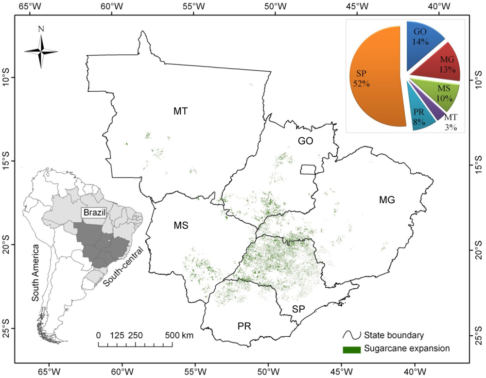
2.1. Study Area


2.2. Materials
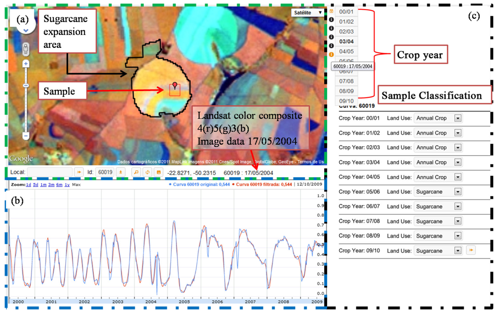
2.3. Methods

 is the estimated proportion of samples that belong to class c. The expansion of the area for each class ac is estimated by
  .
.
 ; whose confidence interval for each class (CIc) is estimated by

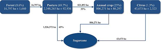
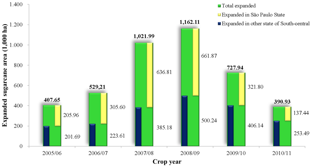
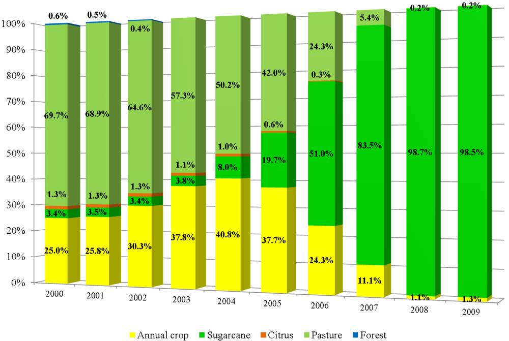
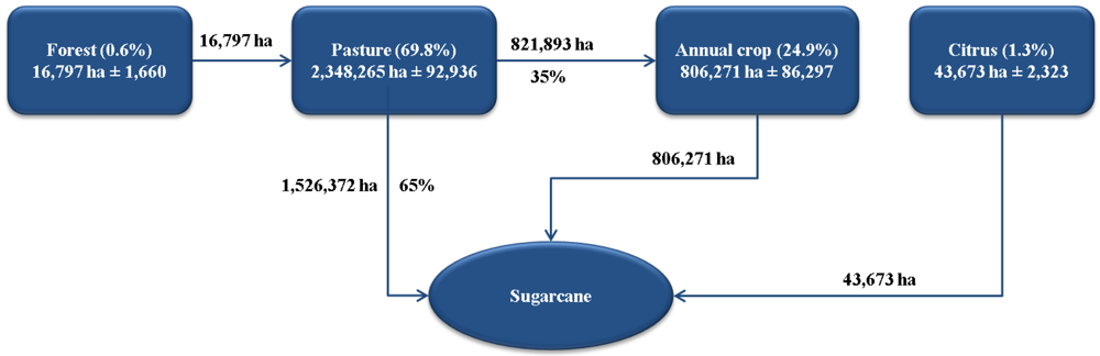
3. Results and Discussion

4. Conclusions
Acknowledgments
Conflict of Interest
References
- Zuurbier, P.J.P.; van de Vooren, J. Sugarcane ethanol: Contributions to climate change mitigation and the environment; Wageningen Academic Publishers: Wageningen, The Netherlands, 2008. [Google Scholar]
- Goldemberg, J. Ethanol for a sustainable energy future. Science 2007, 315, 808–810. [Google Scholar]
- Coelho, S.T.; Goldemberg, J.; Lucon, O.; Guardabassi, P. Brazilian sugarcane ethanol: Lessons learned. Energy Sustain. Dev. 2006, 10, 26–39. [Google Scholar]
- Nass, L.L.; Pereira, P.A.A.; Ellis, D. Biofuels in Brazil: An overview. Crop Sci. 2007, 47, 2228–2237. [Google Scholar]
- Hira, A.; Oliveira, L.G. No substitute for oil? How Brazil developed its ethanol industry. Energy Policy 2009, 37, 2450–2456. [Google Scholar]
- Rudorff, B.F.T.; Aguiar, D.A.; Silva, W.F.; Sugawara, L.M.; Adami, M.; Moreira, M.A. Studies on the rapid expansion of sugarcane for ethanol production in São Paulo State (Brazil) using Landsat data. Remote Sens. 2010, 2, 1057–1076. [Google Scholar]
- Goldemberg, J.; Coelho, S.T.; Guardabassi, P. The sustainability of ethanol production from sugarcane. Energy Policy 2008, 36, 2086–2097. [Google Scholar]
- Smeets, E.; Junginger, M.; Faaij, A.; Walter, A.; Dolzan, P.; Turkenburg, W. The sustainability of Brazilian ethanol: An assessment of the possibilities of certified production. Biomass Bioenergy 2008, 32, 781–813. [Google Scholar]
- Loarie, S.R.; Lobell, D.B.; Asner, G.P.; Mu, Q.; Field, C.B. Direct impacts on local climate of sugar-cane expansion in Brazil. Nat. Clim. Change 2011, 1, 105–109. [Google Scholar]
- Martinelli, L.A.; Garrett, R.; Ferraz, S.; Naylor, R. Sugar and ethanol production as a rural development strategy in Brazil: Evidence from the state of São Paulo. Agric. Syst. 2011, 104, 419–428. [Google Scholar]
- Mueller, S.A.; Anderson, J.E.; Wallington, T.J. Impact of biofuel production and other supply and demand factors on food price increases in 2008. Biomass Bioenergy 2011, 35, 1623–1632. [Google Scholar]
- Hill, J.; Polasky, S.; Nelson, E.; Tilman, D.; Huo, H.; Ludwig, L.; Neumann, J.; Zheng, H.; Bonta, D. Climate change and health costs of air emissions from biofuels and gasoline. Proc. Natl. Acad. Sci. USA 2009, 106, 2077–2082. [Google Scholar]
- Kim, H.; Kim, S.; Dale, B.E. Biofuels, land use change, and greenhouse gas emissions: Some unexplored variables. Environ. Sci. Technol. 2009, 43, 961–967. [Google Scholar] [CrossRef]
- Macedo, I.C.; Seabra, J.E.A.; Silva, J.E.A.R. Green house gases emissions in the production and use of ethanol from sugarcane in Brazil: The 2005/2006 averages and a prediction for 2020. Biomass Bioenergy 2008, 32, 582–595. [Google Scholar]
- Figueiredo, E.B.; La Scala, N., Jr. Greenhouse gas balance due to the conversion of sugarcane areas from burned to green harvest in Brazil. Agric. Ecosyst. Environ. 2011, 141, 77–85. [Google Scholar]
- Lapola, D.M.; Schaldach, R.; Alcamo, J.; Bondeau, A.; Koch, J.; Koelking, C.; Priess, J.A. Indirect land-use changes can overcome carbon savings from biofuels in Brazil. Proc. Natl. Acad. Sci. USA 2010, 107, 3388–3393. [Google Scholar]
- Nassar, A.M.; Rudorff, B.F.T.; Antoniazzi, L.B.; Aguiar, D.A.; Bacchi, M.R.P.; Adami, M. Prospects of the sugarcane expansion in Brazil: Impacts on direct and indirect land use changes. In Sugarcane ethanol: Contributions to climate change mitigation and the environment; Zuurbier, P., van De Vooren, J., Eds.; Wageningen Academic Publishers: Wageningen, The Netherlands, 2008; pp. 63–92. [Google Scholar]
- IBGE: Instituto Brasileiro de Geografia e Estatística. Sistema IBGE de Recuperação Automática. 2011. Available online: http://www.sidra.ibge.gov.br/ (accessed on 15 June 2011).
- CANASAT: Sugarcane Crop Mapping in Brazil by Earth Observing Satellite Images. Maps and Graphs. 2011. Available online: http://www.dsr.inpe.br/laf/canasat/en/map.html (accessed on 15 June 2011).
- Jank, M.S. Etanol: Novo ciclo de crescimento. 2011. Available online: http://www.unica.com.br/opiniao/show.asp?msgCode=3FAE426A-0046-4987-8CAF-C2ADDDF86BF9 (accessed on 23 July 2011).
- Silva, W.F.; Aguiar, D.A.; Rudorff, B.F.T.; Sugawara, L.M. Canasat Project: Monitoring of the sugarcane cultivation area in South central Brazil. In Proceedings of ISPRS TC VII Symposium – 100 Years ISPRS, Vienna, Austria, 5–7 July 2010; Wagner, W., Székely, B., Eds.; ISPRS: Vienna, Austria, 2010; XXXVIII. Part 7B. [Google Scholar]
- Visualisation of MODIS time series for land use and land cover change analyses. 2011. Available online: https://www.dsr.inpe.br/laf/series/en/index.html (accessed on 19 April 2011).
- Cochran, W.G. Sampling techniques; John Wiley & Sons: New York, NY, USA, 1977; p. 428. [Google Scholar]
- NASA. National Aeronautics and Space Administration. The warehouse inventory search tool. Available online: http://edcimswww.cr.usgs.gov/pub/imswelcome/ (accessed on 15 March 2011).
- Vermote, E.F.; Vermeulen, A. Atmospheric correction algorithm: Spectral reflectances (MOD09). Algorithm Theoretical Background. National Aeronautics and Space Administration: 1999. p. 107. Available online: http://modis.gsfc.nasa.gov/data/atbd/atbd_mod08.pdf (accessed on 25 May 2011).
- Freitas, R.M.; Arai, E.; Adami, M.; Ferreira, A.S.; Sato, F.Y.; Shimabukuro, Y.E.; Rosa, R.R.; Anderson, L.O.; Rudorff, B.F.T. Virtual laboratory of remote sensing time series: Visualization of MODIS EVI2 data set over South America. JCIS J. Comput. Interdiscip. Sci. 2011, 2, 57–68. [Google Scholar]
- Sakamoto, T.; Yokozawa, M.; Toritani, H.; Shibayama, M.; Ishitsuka, N.; Ohno, H. A crop phenology detection method using time-series MODIS data. Remote Sens. Environ. 2005, 96, 366–374. [Google Scholar]
- Thayn, J.B.; Price, K.P. Julian dates and introduced temporal error in remote sensing vegetation phenology studies. Int. J. Remote Sens. 2008, 29, 6045–6049. [Google Scholar]
- Daubechies, I. Ten lectures on wavelets; Society for Industrial and Applied Mathematics: Philadelphia, PA, USA, 1992; p. 352. [Google Scholar]
- Jiang, Z.; Huete, A.R.; Didan, K.; Miura, T. Development of a two-band enhanced vegetation index without a blue band. Remote Sens. Environ. 2008, 112, 3833–3845. [Google Scholar]
- CONAB: Companhia Nacional de Abastecimento. In Perfil do Setor de Açúcar e Álcool no Brasil; CONAB: Brasilia, Brazil, 2008; p. 76.
- Boddey, R.M.; Xavier, D.F.; Alves, B.J.R.; Urquiaga, S. Brazilian agriculture: The transition to sustainability. J. Crop Prod. 2003, 9, 593–621. [Google Scholar]
- Naylor, B.Y.R.L.; Liska, A.J.; Burke, M.B.; Falcon, W.P.; Gaskell, J.C.; Rozelle, S.D.; Cassman, K.G. The ripple efect: Biofuels, food security, and the environment. Environment 2007, 49, 30–43. [Google Scholar] [CrossRef]
- Costa, F.P.; Rehman, T. Exploring the link between farmers' objectives and the phenomenon of pasture degradation in the beef production systems of Central Brazil. Agric. Syst. 1999, 61, 135–146. [Google Scholar]
- Searchinger, T.; Heimlich, R.; Houghton, R.A.; Dong, F.; Elobeid, A.; Fabiosa, J.; Tokgoz, S.; Hayes, D.; Yu, T.-H. Use of U.S. croplands for biofuels increases greenhouse gases through emissions from land-use change. Science 2008, 319, 1238–1240. [Google Scholar]
- EPA: Environmental Protection Agency, Draft regulatory impact analysis: Changes to renewable fuel standard program; EPA: Washington, DC, USA, 2009.
- Leite, R.C.; Leal, M.R.; Cortez, L.A.; Griffin, W.M.; Scandiffio, M.I. Can Brazil replace 5% of the 2025 gasoline world demand with ethanol? Energy 2009, 34, 655–661. [Google Scholar] [CrossRef]
- Macedo, L.O.B. Modernização da pecuária de corte bovina no Brasil e a importância do crédito rural. Inf. Econ. 2006, 36, 83–95. [Google Scholar]
- Nassar, A.M. Brazil as an economic superpower. In Brazil as an economic superpower? Understanding Brazil’s changing role in the global economy, 1st; Brainard, L., Martinez‑Diaz, L., Eds.; Brookings Institution: Washington, DC, USA, 2009; pp. 55–80. [Google Scholar]
- CONAB : Companhia Nacional de Abastecimento. Séries históricas relativas às safras 1976/77 a 2009/2010 de área plantada, produtividade e produção; Brasilia, Brazil, 2011. Available online: http://www.conab.gov.br/conteudos.php?a=1252&t=2 (accessed on 17 September 2011).
- Rudorff, B.F.T.; Adami, M.; Aguiar, D.A.; Moreira, M.A.; Mello, M.P.; Fabiani, L.; Amaral, D.F.; Pires, B.M. The soy moratorium in the Amazon biome monitored by remote sensing images. Remote Sens. 2011, 3, 185–202. [Google Scholar]
© 2012 by the authors; licensee MDPI, Basel, Switzerland. This article is an open-access article distributed under the terms and conditions of the Creative Commons Attribution license (http://creativecommons.org/licenses/by/3.0/).
Share and Cite
Adami, M.; Rudorff, B.F.T.; Freitas, R.M.; Aguiar, D.A.; Sugawara, L.M.; Mello, M.P. Remote Sensing Time Series to Evaluate Direct Land Use Change of Recent Expanded Sugarcane Crop in Brazil. Sustainability 2012, 4, 574-585. https://doi.org/10.3390/su4040574
Adami M, Rudorff BFT, Freitas RM, Aguiar DA, Sugawara LM, Mello MP. Remote Sensing Time Series to Evaluate Direct Land Use Change of Recent Expanded Sugarcane Crop in Brazil. Sustainability. 2012; 4(4):574-585. https://doi.org/10.3390/su4040574
Chicago/Turabian StyleAdami, Marcos, Bernardo Friedrich Theodor Rudorff, Ramon Morais Freitas, Daniel Alves Aguiar, Luciana Miura Sugawara, and Marcio Pupin Mello. 2012. "Remote Sensing Time Series to Evaluate Direct Land Use Change of Recent Expanded Sugarcane Crop in Brazil" Sustainability 4, no. 4: 574-585. https://doi.org/10.3390/su4040574