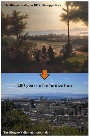
Geomorphological Landscape Research and Flood Management in a Heavily Modified Tyrrhenian Catchment


 ,
,  , ,
, ,
Abstract
:
1. Introduction
2. Literature Review
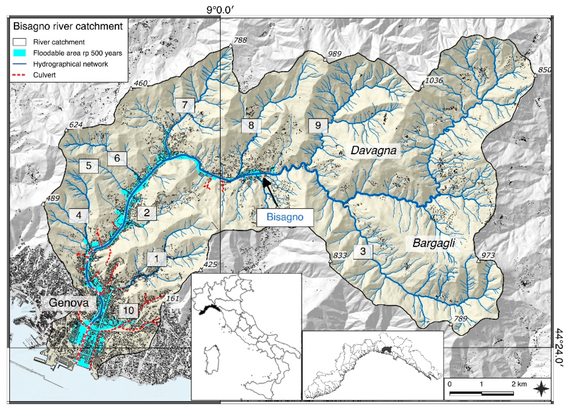
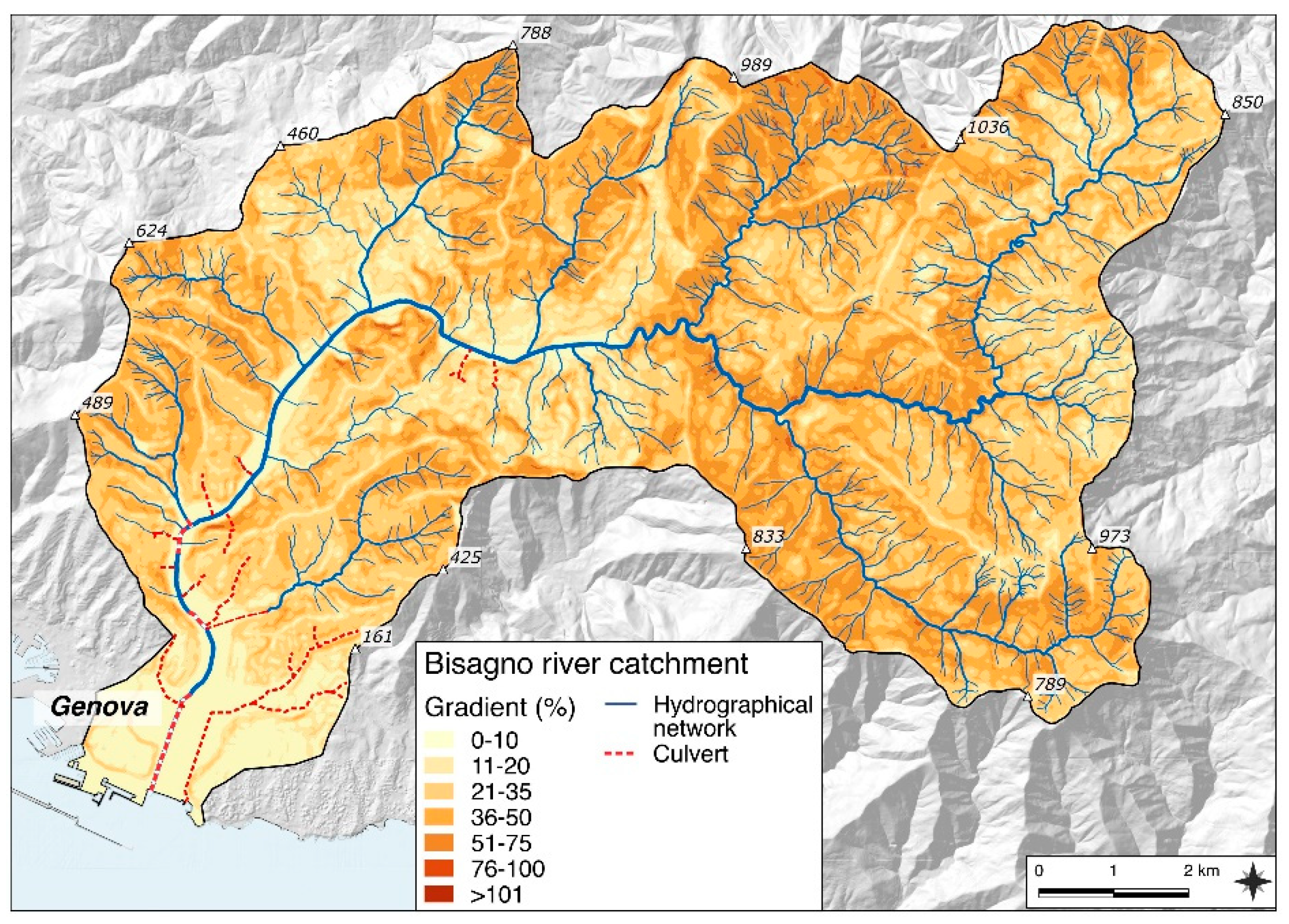
3. Study Area
4. Methods
4.1. Land Use Change Assessment
4.2. Scientific and Quantitative Evaluation
5. Results
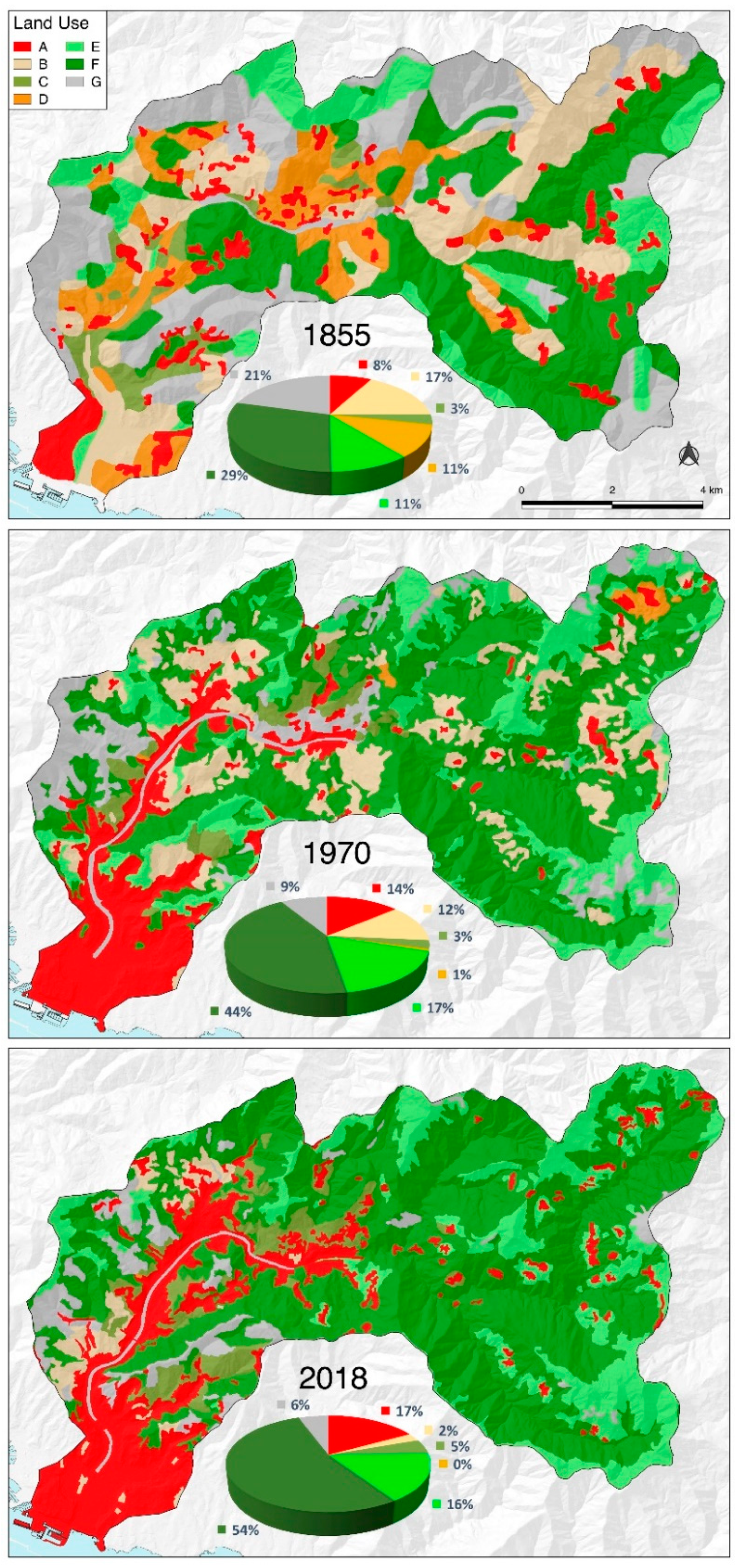
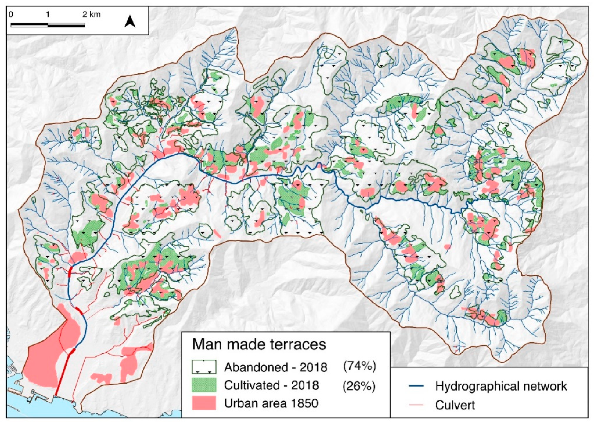
5.1. Landscape Changes
5.1.1. Land Use Changes
5.1.2. Urban Geomorphology
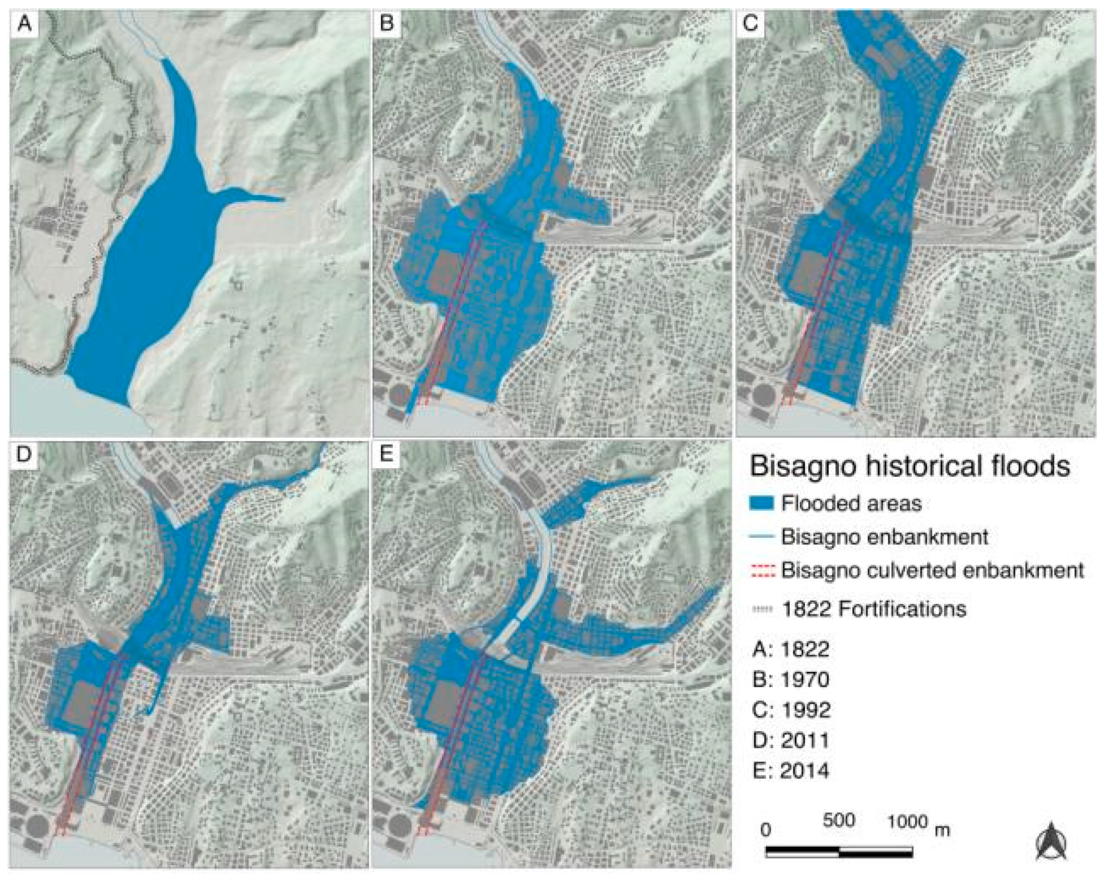
5.2. Floodplain Changes and Main Floods
5.2.1. Floodplain and Riverbed Changes
5.2.2. Main Floods of the Bisagno
6. Discussion
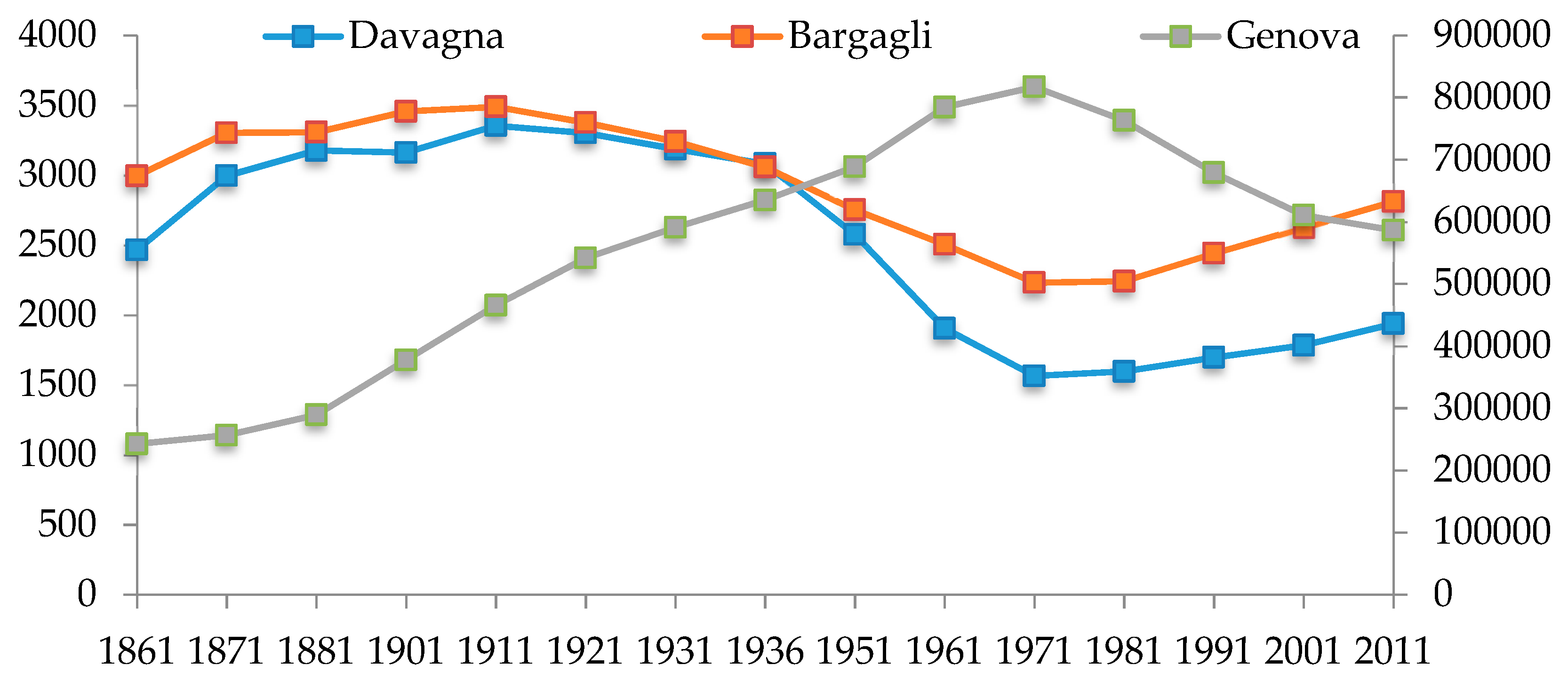
6.1. Some Remarks on Land Use, Anthropogenic and Demographic Changes in the Bisagno Valley
6.2. Landscape Planning for Flood Management
- (a)
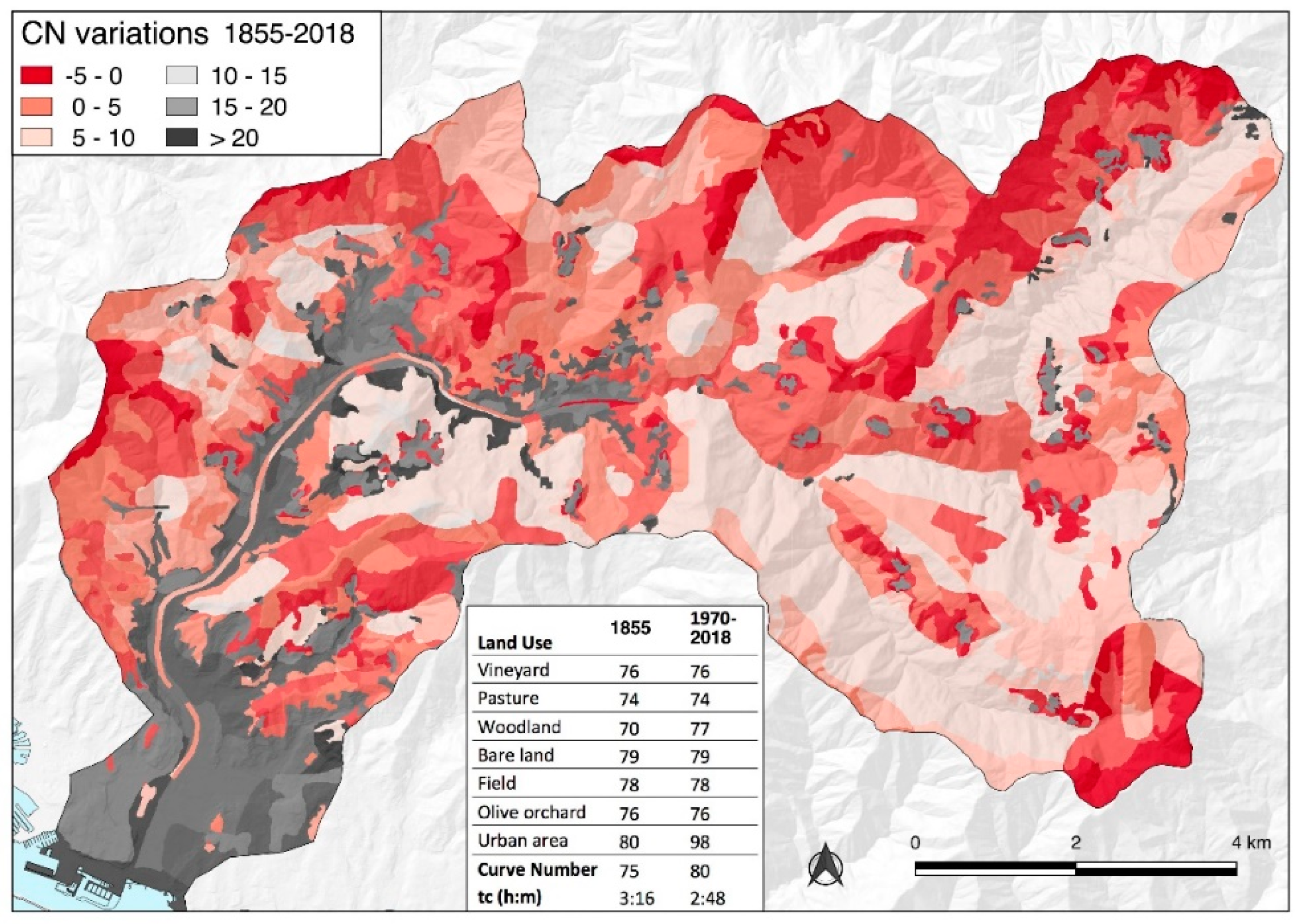
- Landscape maintenance: Small, timely and widespread maintenance interventions, particularly in the upper slope, would reduce runoff and solid transport and increase time of concentration. Given the significant reduction in the time of concentration that has occurred in the last three centuries (Figure 5), widespread interventions are almost crucial, in particular the management of terraces to avoid gullying. Access to funding should be facilitated, while specific financial rewards should be given to local stakeholders involved in sustainable landscape management policies [11]. Land use planning at the watershed level should be promoted and an authority at this level is recommended [74,75].
- (b)
- Socio-environmental policy: Following the industrial boom of the post-war period, rural areas became marginal and have been largely neglected by politicians and the public opinion. In this sense, specific policies to encourage rural population recovery and promote sustainable but profitable agriculture and outdoor activities should be developed. The delocalization of businesses, as well as the improvement of transport and infrastructure, could encourage people to move to the countryside and reduce human pressure on the city centre. New sustainable outdoor rural activities in areas which have been devoted to agriculture for centuries would allow a diversification of the land use typology, for the benefit of flood hazard mitigation, as well as for the aesthetic value of the landscape [76,77,78].
- (c)
- Landscape planning: Landscape diversification would also be improved by the establishment of new green urban areas, parks and sustainable urban drainage in the lower Bisagno valley, intensively urbanised and characterized by a very high CN. Green infrastructures would not only reduce runoff, but also contribute to absorb carbon and increase environmental quality near urban areas [79].
- (d)
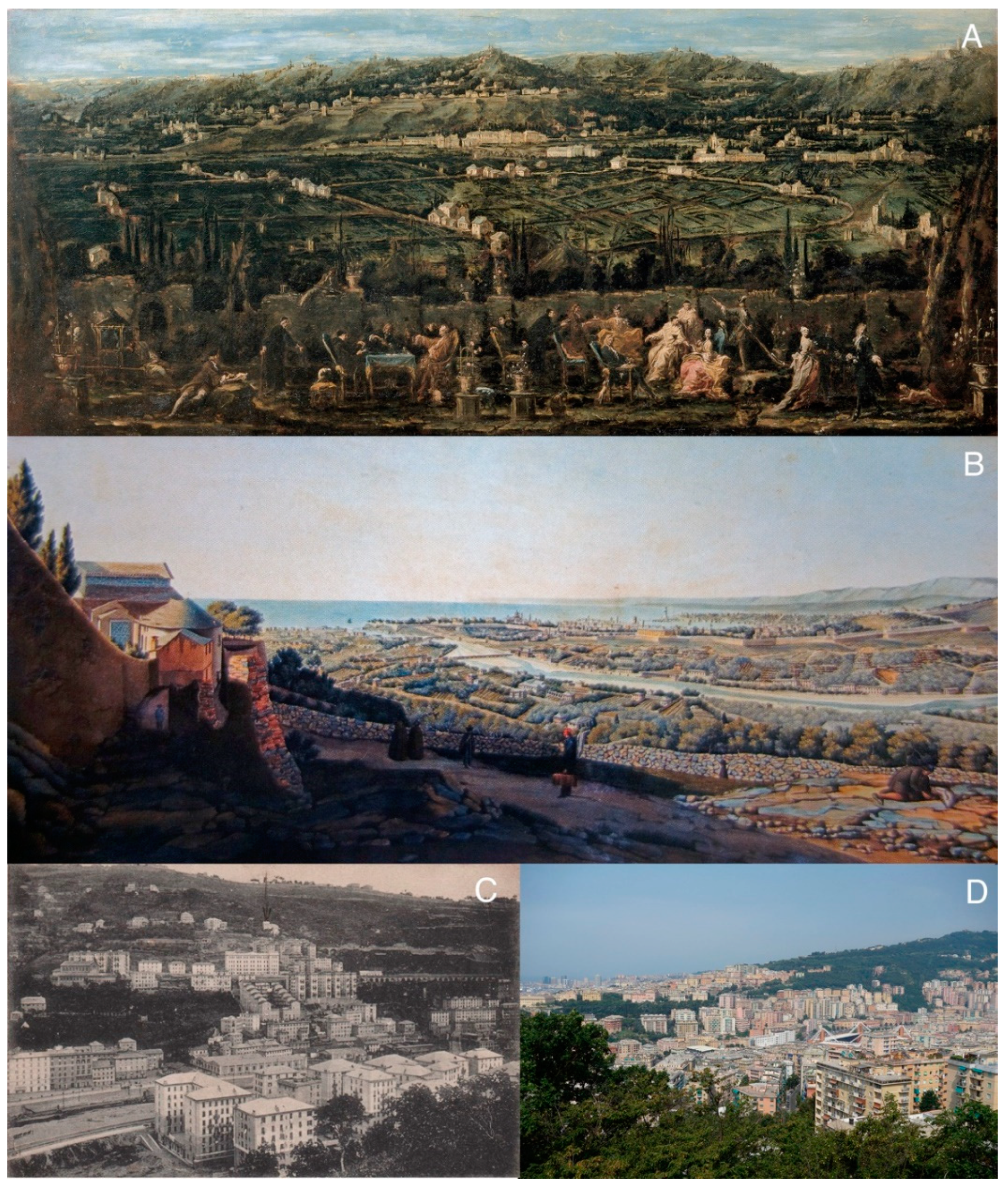
- Public engagement: Urban resilience and public awareness campaigns should be further promoted, and the local population should be actively involved in the management of the territory, including the maintenance of traditional drainage channels associated with terrace agriculture [80,81]. The wealth of historical documents, some of them analysed in this work, are a valuable tool for educational activities on the landscape evolution of the valley and its connection with floods. Further efforts should be aimed at reducing the gap between institutions at national and European level and the local communities, in order to increase their involvement in the decision-making process, a problem which is common to many rural areas of Europe [82].
7. Conclusions
Author Contributions
Funding
Conflicts of Interest
References
- Brenner, R. Agrarian Class Structure and Economic Development in Pre-Industrial Europe. Past Present 1976, 70, 30–75. [Google Scholar] [CrossRef]
- Antrop, M. Landscape change and the urbanization process in Europe. Landsc. Urban Plan. 2004, 67, 9–26. [Google Scholar] [CrossRef]
- Grove, A.T.; Rackham, O. The Nature of Mediterranean Europe: An Ecological History; Yale University Press: London, UK, 2001; p. 384. ISBN 0-300-08443-9. [Google Scholar]
- Agnoletti, M. Valorizing the European rural landscape: The Italian national register of historical rural landscapes. In Proceedings of the international conference The European Landscape Convention in Research Perspective, Florence, Italy, 18–19 October 2010; pp. 59–85. [Google Scholar]
- Moreno, D. Dal Documento al Terreno (From the Document to the Field); Il Mulino: Bologna, Italy, 1990; p. 276. ISBN 8815025197. [Google Scholar]
- Zomeni, M.; Tzanopoulos, J.; Pantis, J.D. Historical analysis of landscape change using remote sensing techniques: An explanatory tool for agricultural transformation in Greek rural areas. Landsc. Urban Plan. 2008, 86, 38–46. [Google Scholar] [CrossRef]
- Antrop, M. Changing patterns in the urbanized countryside of Western Europe. Landsc. Ecol. 2000, 15, 257–270. [Google Scholar] [CrossRef]
- Viciani, D.; Dell’Olmo, L.; Gabellini, A.; Gigante, D.; Lastrucci, L. Landscape dynamics of Mediterranean montane grasslands over 60 years and implications for habitats conservation. A case study in the northern Apennines (Italy). Landsc. Res. 2017, 43, 952–964. [Google Scholar] [CrossRef]
- Hearn, R.; Watkins, C.; Balzaretti, R. The cultural and land use implications of the reappearance of the wild boar in North West Italy: A case study in the Val di Vara. J. Rural Stud. 2014, 36, 52–63. [Google Scholar] [CrossRef]
- Ureña, J.M.; Ollero, A. Fluvial Landscapes, Catchment Administration and Land-use Planning: Experience based on two rivers in Spain. Landsc. Res. 2010, 26, 225–243. [Google Scholar] [CrossRef]
- Wheater, H.; Evans, E. Land use, water management and future flood risk. Land Use Policy 2009, 26, 251–264. [Google Scholar] [CrossRef]
- Latocha, A. Land-use changes and longer-term human–environment interactions in a mountain region (Sudetes Mountains, Poland). Natural versus human-induced effects. Geomorphology 2009, 108, 48–57. [Google Scholar] [CrossRef]
- Boudou, M.; Danière, B.; Lang, M. Assessing changes in urban flood vulnerability through mapping land use from historical information. Hydrol. Earth Syst. Sci. 2016, 20, 161–173. [Google Scholar] [CrossRef]
- Luino, F.; Nigrelli, G.; Turconi, L.; Faccini, F.; Agnese, C.; Casillo, F. A proper land-use planning through the use of historical research. Disaster Adv. 2015, 9, 789–801. Available online: https://worldresearchersassociations.com/Archives/DA/Vol(9)2016/January2016.aspx (accessed on 4 July 2019).
- Ward, P.J.; Van Balen, R.T.; Verstraeten, G.; Renssen, H.; Vandenberghe, J. The impact of land-use and climate change on Late Holocene and future suspended sediment yield of the Meuse catchment. Geomorphology 2009, 103, 389–400. [Google Scholar] [CrossRef]
- Brancucci, G.; Paliaga, G. The hazard assessment in a terraced landscape: The Liguria (Italy) case study in Interreg III Alpter project. In Geohazards—Technical, Economical and Social Risk Evaluation; Berkely Electronics Press: Berkeley, CA, USA, 2006; pp. 1–10. [Google Scholar]
- Agnoletti, M.; Errico, A.; Santoro, A.; Dani, A.; Preti, F. Terraced landscapes and hydrogeological risk. Effects of land abandonment in Cinque Terre (Italy) during severe rainfall events. Sustainability 2019, 11, 235. [Google Scholar] [CrossRef]
- Paliaga, G.; Giostrella, P.; Faccini, F. Terraced landscape as cultural and environmental heritage at risk: An example from Portofino Park (Italy). Annal. Ser. Hist. Sociol. 2016, 26, 1–10. [Google Scholar] [CrossRef]
- Montanari, A.; Young, G.; Savenije, H.H.G.; Hughes, D.; Wagener, T.; Ren, L.L.; Koutsoyiannis, D.; Cudennec, C.; Toth, E.; Grimaldi, S.; et al. Panta Rhei—Everything Flows: Change in hydrology and society- The IAHS Scientific Decade 2013–2022. Hydrol. Sci. J. 2013, 58, 1256–1275. [Google Scholar] [CrossRef]
- Jansa, A.; Alpert, P.; Arbogast, P.; Buzzi, A.; Ivancan-Picek, B.; Kotroni, V.; Llasat, M.C.; Ramis, C.; Richard, E.; Romero, R.; et al. MEDEX: A general overview. Nat. Hazards Earth Syst. Sci. 2014, 14, 1965–1984. [Google Scholar] [CrossRef]
- Llasat, M.C.; Ghabeli, J.; Turco, M.P. Flash flood evolution in North Western Mediterranean. Atmos. Res. 2014, 149, 230–243. [Google Scholar] [CrossRef]
- Marchi, L.; Cavalli, M.; Amponsah, W.; Borga, M.; Crema, S. Upper limits of flash flood stream power in Europe. Geomorphology 2016, 272, 68–77. [Google Scholar] [CrossRef]
- Paliaga, G.; Donadio, C.; Bernardi, M.; Faccini, F. High-Resolution Lightning Detection and Possible Relationship with Rainfall Events over the Central Mediterranean Area. Remote Sens. 2019, 11, 1601. [Google Scholar] [CrossRef]
- Guzzetti, F.; Tonelli, G. Information system on hydrological and geomorphological catastrophes in Italy (SICI): A tool for managing landslide and flood hazards. Nat. Hazards Earth Syst. Sci. 2004, 4, 213–232. [Google Scholar] [CrossRef]
- Faccini, F.; Piccazzo, M.; Robbiano, A. Natural hazards in San Fruttuoso of Camogli (Portofino Park, Italy): A case study of a debris flow in a coastal environment. Boll. Soc. Geol. It. 2009, 128, 641–654. [Google Scholar] [CrossRef]
- Faccini, F.; Piccazzo, M.; Robbiano, A.; Roccati, A. Applied Geomorphological Map of the Portofino municipal territory (Italy). J. Maps 2008, 4, 451–462. [Google Scholar] [CrossRef]
- Roccati, A.; Luino, F.; Turconi, L.; Piana, P.; Watkins, C. Historical geomorphological research of a Ligurian coastal floodplain (Italy) and its value for management of flood risk and environmental sustainability. Sustainability 2018, 10, 3727. [Google Scholar] [CrossRef]
- Luino, F.; Paliaga, G.; Roccati, A.; Sacchini, A.; Turconi, L.; Faccini, F. Anthropogenic changes in the alluvial plains of the Tyrrhenian Ligurian basins. Rend. Online Soc. Geol. It. 2019, 48, 10–16. [Google Scholar] [CrossRef]
- Sacchini, A.; Faccini, F.; Ferraris, F.; Firpo, M.; Angelini, S. Large-scale landslide and Deep-Seated Gravitational Slope Deformation of the Upper Scrivia Valley (Northern Apennine, Italy). J. Maps 2015, 12, 344–358. [Google Scholar] [CrossRef]
- Faccini, F.; Robbiano, A.; Sacchini, A. Geomorphic hazard and intense rainfall: The case study of the Recco Stream Catchment (Eastern Liguria, Italy). Nat. Hazards Earth Syst. Sci. 2012, 12, 893–903. [Google Scholar] [CrossRef]
- Paliaga, G.; Faccini, F.; Luino, F.; Turconi, L. A spatial multicriteria prioritizing approach for geohydrological risk mitigation planning in small and densely urbanized Mediterranean basins. Nat. Hazards Earth Syst. Sci. 2019, 19, 53–69. [Google Scholar] [CrossRef]
- Faccini, F.; Luino, F.; Sacchini, A.; Turconi, L.; De Graaf, J.V. Geohydrological hazards and urban development in the Mediterranean area: An example from Genoa (Liguria, Italy). Nat. Hazards Earth Syst. Sci. 2015, 15, 2631–2652. [Google Scholar] [CrossRef]
- Paliaga, G.; Luino, F.; Turconi, L.; Faccini, F. Inventory of geo-hydrological phenomena in Genoa Municipality (NW Italy). J. Maps 2018, 15, 28–37. [Google Scholar] [CrossRef]
- Faccini, F.; Luino, F.; Paliaga, G.; Sacchini, A.; Turconi, L.; de Jong, C. Role of rainfall intensity and urban sprawl in the 2014 flash flood in Genoa City, Bisagno catchment (Liguria, Italy). Appl. Geogr. 2018, 98, 224–241. [Google Scholar] [CrossRef]
- Faccini, F.; Luino, F.; Paliaga, G.; Sacchini, A.; Turconi, L. Yet another disaster flood of the Bisagno stream in Genoa (Liguria, Italy): 9–10 October 2014 event. Rend. Online Soc. Geol. It. 2015, 35, 128–131. [Google Scholar] [CrossRef]
- Faccini, F.; Luino, F.; Sacchini, A.; Turconi, L. The 4th October 2010 flash flood event in Genoa Sestri Ponente (Liguria, Italy). Disaster Adv. 2015, 8, 1–14. [Google Scholar]
- Acquaotta, F.; Faccini, F.; Fratianni, S.; Paliaga, G.; Sacchini, A.; Vilìmek, V. Increased flash flooding in Genoa Metropolitan Area: A combination of climate changes and soil consumption? Meteorol. Atmos. Phys. 2018, 1–12. [Google Scholar] [CrossRef]
- Acquaotta, F.; Faccini, F.; Fratianni, S.; Paliaga, G.; Sacchini, A. Rainfall intensity in the Genoa Metropolitan Area (Northern Mediterranean): Secular variations and consequences. Weather 2018. [Google Scholar] [CrossRef]
- Basoni, A.; Pepe, M.; Brivio, A.; Mancini, M. Effect of seasonal land use cover from satellite data on surface runoff in two Mediterranean catchments. Remote Sens. Agric. Ecosyst. Hydrol. II 2000. [Google Scholar] [CrossRef]
- Rosso, R.; Rulli, M.C. An integrated simulation method for flash flood risk assessment: 1. Frequency predictions in the Bisagno River by combining stochastic and deterministic methods. Hydrol. Earth Syst. Sci. 2002, 6, 267–284. [Google Scholar]
- Rulli, M.C.; Rosso, R. An integrated simulation method for flash-flood risk assessment: 2. Effects of changes in land-use under a historical perspective. Hydrol. Earth Syst. Sci. 2002, 6, 285–294. [Google Scholar] [CrossRef] [Green Version]
- Silvestro, F.; Gabellani, S.; Giannoni, F.; Parodi, A.; Rebora, N.; Rudari, R.; Siccardi, F. A hydrological analysis of the 4 November 2011 event in Genoa. Nat. Hazards Earth Syst. Sci. 2012, 12, 2743–2752. [Google Scholar] [CrossRef]
- Silvestro, F.; Rebora, N.; Giannoni, F.; Cavallo, A.; Ferraris, L. The flash flood of the Bisagno Creek on 9th October 2014: An unfortunate combination of spatial and temporal scales. J. Hydr. 2016, 541, 50–62. [Google Scholar] [CrossRef]
- Paliaga, G.; Faccini, F.; Luino, F.; Turconi, L.; Bobrowsky, P. Geomorphic processes and risk related to a large landslide dam in a highly urbanized Mediterranean catchment (Genova, Italy). Geomorphology 2019, 327, 48–61. [Google Scholar] [CrossRef]
- Faccini, F.; Paliaga, G.; Piana, P.; Sacchini, A.; Watkins, C. The Bisagno stream catchment (Genoa, Italy) and its major floods: Geomorphic and land use variations in the last three centuries. Geomorphology 2016, 273, 14–27. [Google Scholar] [CrossRef]
- Radaelli, P.; Bringiotti, M. The Fereggiano River diversion in Genoa. In Tunnels and Underground Cities: Engineering and Innovation Meet Archaeology, Architecture and Art; Peila, D., Viggiani, G., Celestino, T., Eds.; CRC Press: Boca Raton, FL, USA, 2019; pp. 6110–6119. [Google Scholar]
- Brandolini, P.; Cevasco, A.; Firpo, M.; Robbiano, A.; Sacchini, A. Geo-hydrological risk management for civil protection purposes in the urban area of Genoa (Liguria, NW Italy). Nat. Hazards Earth Syst. Sci. 2012, 12, 943–959. [Google Scholar] [CrossRef] [Green Version]
- Brandolini, P.; Faccini, F.; Paliaga, G.; Piana, P. Man-Made landforms survey and mapping of an urban historical centre in a coastal Mediterranean environment. Geogr. Fis. Din. Quat. 2018, 41, 23–34. [Google Scholar] [CrossRef]
- Autorità di Bacino Regionale. Piano di Bacino Torrente Bisagno, Relazione Generale; Regione Liguria: Genova, Italy, 2017. [Google Scholar]
- Sacchini, A.; Ferraris, F.; Faccini, F.; Firpo, M. Environmental climatic maps of Liguria. J. Maps 2012, 8, 199–207. [Google Scholar] [CrossRef]
- Crutzen, P.J. Geology of mankind. Nature 2002, 415, 3. [Google Scholar] [CrossRef] [PubMed]
- Bürgi, M.; Silbernagel, J.; Wu, J.; Kienast, F. Linking ecosystem services with landscape history. Landsc. Ecol. 2015, 30, 11–20. [Google Scholar] [CrossRef]
- Marcucci, D.J. Landscape history as a planning tool. Landsc. Urban Plan. 2000, 49, 67–81. [Google Scholar] [CrossRef]
- Agnoletti, M. The development of a historical and cultural evaluation approach in landscape assessment: The dynamic of Tuscan Landscape between 1832 and 2004. In The Conservation of Cultural Landscapes; Agnoletti, M., Ed.; CAB International: Wallingford, UK, 2006; pp. 3–29. [Google Scholar]
- Harvey, F.; Kaim, D.; Gajda, A. Analysis of historical change using cadastral materials in the Carpathian foothills. Eur. J. Geogr. 2014, 5, 6–21. Available online: http://www.eurogeographyjournal.eu/articles/EJG050301_ANALYSIS%20OF%20HISTORICAL%20CHANGE%20.pdf (accessed on 20 July 2019).
- Cevasco, R. La copertura vegetale dell’alta Val Trebbia nelle ricognizioni topografiche del Corpo di Stato Maggiore Sardo (The vegetation cover in Upper Trebbia Valley by the Royal Sardinian Army topographical surveyes). Archeol. Postmediev. 2002, 6, 195–214. [Google Scholar]
- Tarolli, P.; Sofia, G.; Calligaro, S.; Prosdocimi, M.; Preti, F.; Della Fontana, G. Vineyards in Terraced Landscapes: New Opportunities from Lidar Data. Land Degrad. Dev. 2014, 26, 92–102. [Google Scholar] [CrossRef]
- Watkins, C. The management history and conservation of terraces in the Val di Vara, Liguria. In Ligurian Landscapes Studies in Archaeology, Geography and History; Balzaretti, R., Pearce, M., Watkins, C., Eds.; Accordia: London, UK, 2004; pp. 141–154. [Google Scholar]
- Piana, P.; Balzaretti, R.; Moreno, D.; Watkins, C. Topographical art and landscape history: Elizabeth Fanshawe in early nineteenth-century Liguria. Landsc. Hist. 2012, 33, 65–82. [Google Scholar] [CrossRef]
- Piana, P.; Watkins, C.; Balzaretti, R. Art and landscape history: British artists in nineteenth-century Val d’Aosta. Landsc. Hist. 2018, 39, 91–108. [Google Scholar] [CrossRef]
- Soil Conservation Service. National Engineering Handbook, Section 4, Hydrology; United States Department of Agriculture: Washington, DC, USA, 1972. [Google Scholar]
- McCuen, R.H. Guide to Hydrologic Analysis Using SCS Methods; Prentice Hall: Englewood Cliffs, NJ, USA, 1982. [Google Scholar]
- Romero, P.; Castro, G.; Gómez, J.A.; Fereres, E. Curve Number Values for Olive Orchards under Different Soil Management. Soil Sci. Soc. Am. J. 2007, 71, 1758–1769. [Google Scholar] [CrossRef]
- Mishra, S.K.; Singh, V. Soil Conservation Service, Curve Number (SCS-CN) Methodology; Springer: Berlin/Heidelberg, Germany, 2003. [Google Scholar]
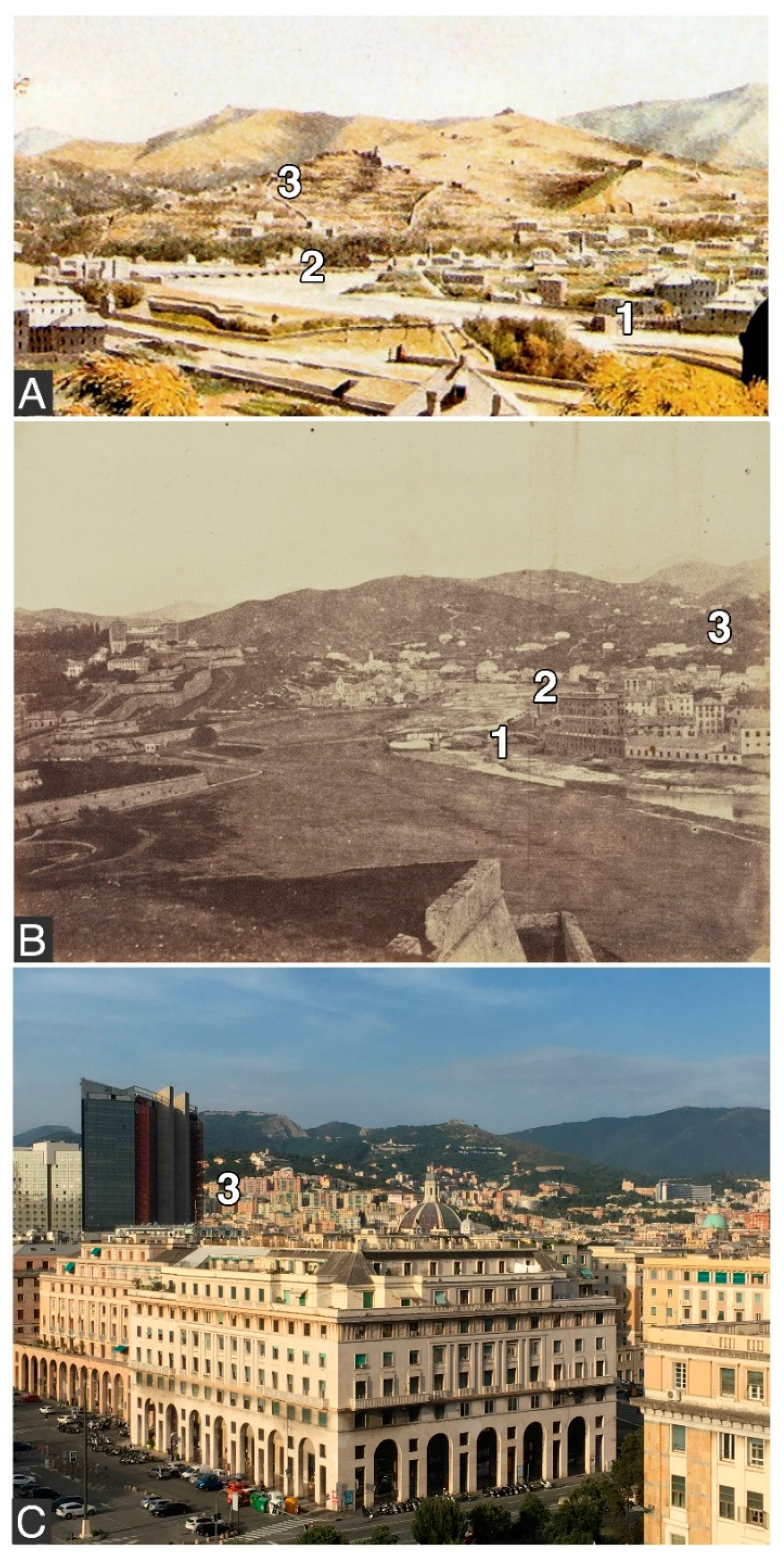
- Poleggi, E. Iconografia di Genova e Delle Due Riviere [Iconography of Genoa and the two Rivieras]; Sagep: Genova, Italy, 1976. [Google Scholar]
- Rosenbaum, M.S.; McMillan, A.A.; Powell, J.H.; Cooper, A.H.; Culshaw, M.G.; Northmore, K.J. Classification of artificial (man-made) ground. Eng. Geol. 2003, 69, 399–409. [Google Scholar] [CrossRef] [Green Version]
- Faccini, F.; Luino, F.; Sacchini, A.; Turconi, L. Flash flood events and urban development in Genoa (Italy): Lost in translation. In Engineering Geology for Society and Territory; Lollino, G., Manconi, A., Guzzetti, F., Culshaw, M., Bobrowsky, P., Luino, F., Eds.; Springer International Publishing: Cham, Switzerland, 2014; Volume 5, pp. 797–801. [Google Scholar]
- US Department of Agriculture, National Resources Conservation Service. National Engineering Handbook Hydrology Chapters; US Department of Agriculture: Washington, DC, USA, 2000; p. 530.
- Sorg, L.; Medina, N.; Feldmeyer, D.; Sanchez, A.; Vojinovic, Z.; Birkmann, J.; Marchese, A. Capturing the multifaceted phenomena of socioeconomic vulnerability. Nat. Haz. 2018, 92, 257–282. [Google Scholar] [CrossRef] [Green Version]
- Rhoads, B.L.; Lewis, Q.W.; Andresen, W. Historical changes in channel network extent and channel planform in an intensively managed landscape. Geomorphology 2016, 252, 17–31. [Google Scholar] [CrossRef]
- Lunardi, G.; Cassani, G.; Gatti, M.; Spigarelli, B.; Zenti, C.L. Resilient city: The case of Bisagno diversion tunnel. In Tunnels and Underground Cities: Engineering and Innovation Meet Archaeology, Architecture and Art; Peila, D., Viggiani, G., Celestino, T., Eds.; CRC Press: Boca Raton, NY, USA, 2019; pp. 5159–5169. [Google Scholar]
- Ferrari, M.; Belicchi, M.; Cerlini, D.; Majone, U. The Bisagno River Diversion. In Proceedings of the International Conference on Fluvial Hydraulics River Flow, Lausanne, Switzerland, 3–5 September 2014; pp. 1757–1765. [Google Scholar] [CrossRef]
- Rogger, M.; Agnoletti, M.; Alaoui, A.; Bathurst, J.C.; Bodner, G.; Borga, M.; Chaplot, V.; Gallart, F.; Glatzel, G.; Hall, J.; et al. Land use change impacts on floods at the catchment scale: Challenges and opportunities for future research. Water Resour. Res. 2017, 53, 5209–5219. [Google Scholar] [CrossRef] [Green Version]
- Erickson, D.L. Rural land use and land cover change: Implications for local planning in the River Raisin watershed. Land Use Policy 1995, 12, 223–236. [Google Scholar] [CrossRef]
- Sharma, A.; Tiwari, K.N.; Bhadoria, P.B.S. Effect of land use land cover change on soil erosion potential in an agricultural watershed. Environ. Monit. Assess. 2011, 173, 789–801. [Google Scholar] [CrossRef]
- Sacchini, A.; Imbrogio Ponaro, M.; Paliaga, G.; Piana, P.; Faccini, F.; Coratza, P. Geologial Landscape and Stone Heritage of the Genoa Walls Urban Park and surrounding area (Italy). J. Maps 2018, 14, 528–541. [Google Scholar] [CrossRef]
- Huang, Q.; Huang, J.; Yang, X.; Ren, L.; Tang, C.; Zhao, L. Evaluating the Scale Effect of Soil Erosion Using Landscape Pattern Metrics and Information Entropy: A Case Study in the Danjiangkou Reservoir Area, China. Sustainability 2017, 9, 1243. [Google Scholar] [CrossRef]
- Jung, H.J.; Ryu, J.H. Sustaining a Korean Traditional Rural Landscape in the Context of Cultural Landscape. Sustainability 2015, 7, 11213–11239. [Google Scholar] [CrossRef] [Green Version]
- Ellis, J.B. Sustainable surface water management and green infrastructure in UK urban catchment planning. J. Env. Plan. Manag. 2013, 56, 24–41. [Google Scholar] [CrossRef]
- Meerow, S.; Newell, J.P.; Stults, M. Defining Urban resilience: A review. Landsc. Urban Plan. 2016, 147, 38–49. [Google Scholar] [CrossRef]
- Rounsevell, M.; Reay, D. Land use and climate change in the UK. Land Use Policy 2009, 26, 160–169. [Google Scholar] [CrossRef]
- Pinto Correia, T.; Gustavsson, R.; Pirnat, J. Bridging the gap between centrally defined policies and local decisions-towards more sensitive and creative rural landscape management. Landsc. Ecol. 2006, 21, 333–346. [Google Scholar] [CrossRef]


| Main Bisagno Tributaries | Slope | Geomorphological Features | Catchment Surface (km2) | Lenght (km) | Max Altitude (M asl) |
|---|---|---|---|---|---|
| 1. Fereggiano | left | Main urban, only upper part natural | 4.9 | 4.7 | 555 (Mt. Forte Ratti) |
| 2. Mermi | left | Main urban | 2.2 | 2.0 | 480 (slopes of Mt. Forte Ratti) |
| 3. Lentro | left | Mountain | 11.6 | 7.5 | 894 (Mt. Becco) |
| 4. Veilino | right | Only plain strongly urbanised | 3.3 | 2.9 | 640 (Mt. Forte FratelloMinore) |
| 5. Cicala | right | Only plain strongly urbanised | 1.5 | 2.5 | 650 (Mt. Forte Fratello Maggiore) |
| 6. Trensasco | right | Only plain strongly urbanised | 2.7 | 3.5 | 670 (Mt. Forte Diamante) |
| 7. Geirato | right | Only plain strongly urbanised | 7.6 | 4.3 | 790 (Mt. Alpe) |
| 8. Torbido | right | Only plain strongly urbanised | 6 | 4.8 | 984 (Mt. Alpesisa) |
| 9. Canate | right | Mountain | 8.8 | 5.4 | 1032 (Mt. Bastia di Marsiglia) |
| 10. Noce | left | Totally urbanised and artificially diverse | Originally c. 3 | 2.7 | 320 (Camaldoli) |
| Bisagno | 95 | 25.0 | 1034 (Mt. Candelozzo) |
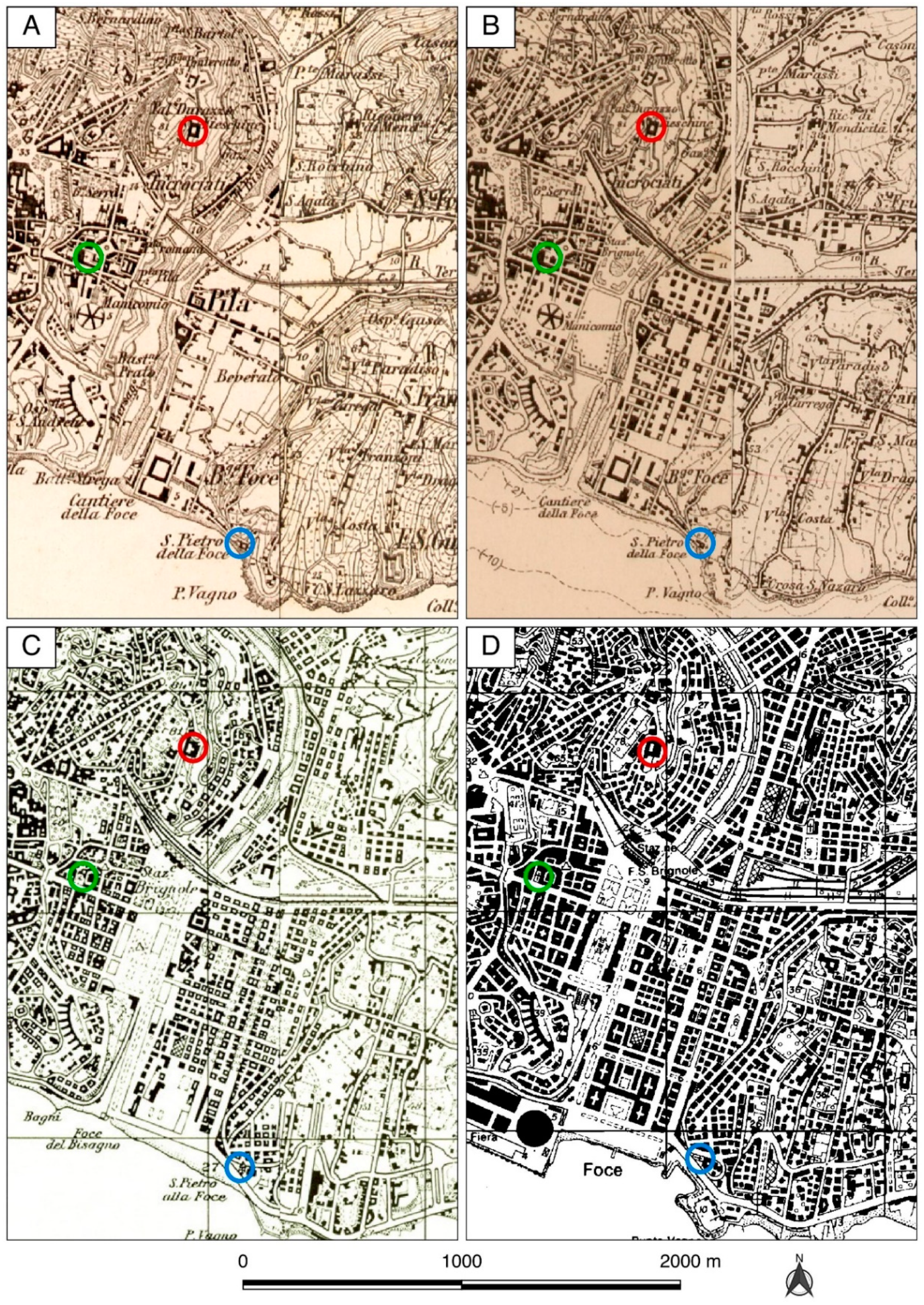
| Map | Authority | Scale | Year | Fig./Tab. Reference |
|---|---|---|---|---|
| Printed topographical map | Savoy Kingdom Army | 1:50,000 | 1853 | 3a, 4, 5 |
| Various manuscript topographical maps | Savoy Kingdom Army | 1:9450 | c.1820 | 5, 10a |
| Topographical map | Italian Military Geographical Institute | 1:25,000 | 1907, 1939 | 7 |
| Topographical map | Liguria Region | 1:25,000 | 1995 | 7 |
| Thematic maps related to regional land use | Liguria Region | 1:25,000 | 1973–1975 | 1, 2, 3b, 4 |
| Technical map | Liguria Region | 1:5000 | 1990–2007 | 4, 10b–e, tab1 |
| Digital Terrain Model | Liguria Region | 1:5000 | 2007 | 1, 2, 7, 10b–e |
| Land use | Liguria Region | 1:25,000 | 2012 | 3c, 5 |
| Urban evolution | Liguria Region | 1:25,000 | 1986 | 7 |
| Storm Event Date | Flood Event | Discharge Estimated in the Final Stretch | Damage and Fatalities |
|---|---|---|---|
| 1822/10/25 | Regular 24-h flood, with a final 3-h peak (total 812 mm/24 h) in the lower Bisagno catchment (Marassi) | 1200 m3/s | Collapse of two bridges and mud and water up to second floor of houses |
| 1842/8/25 | Regular 10-h flood, flooding of many streams in the final part of the catchment | 600 m3/s | Mud and water up to second floor of houses |
| 1872/10/17 | Regular 48-h flood above all in the western and top part of the catchment and flooding of the final stretch | >300 m3/s | Unknown |
| 1892/10/08 | Regular 24-h flood in the upper catchment | >300 m3/s | Unknown |
| Storm Event Date | Flood Event | Discharge Estimated in the Final Stretch | Damage and Fatalities |
|---|---|---|---|
| 1907/10/10 | Regular 24-h flood, overflowing in the middle and final stretch of the stream | 500 m3/s | Unknown |
| 1908/07/18 | Regular 9-h flood in the middle-upper part of the catchment, with a 1.5-h rainfall peak | Approximately 450 m3/s | Flooding of the Foce district |
| 1945/10/29 | Flash flood (6 h) in the western slope with overflowing of the final stretch. | >450 m3/s | The river overflowed upstream of the cover |
| 1953/09/19 | Flash flood (5 h peak) in the western slope and in the middle and lower part of the catchment with complete overflowing | 800 m3/s | Damage losses for Genoa area: ITL 50 billion (over EUR 25 million) |
| 1970/10/08 | Regular 24-h flood, overflowing of the middle and final stretch and tributaries. | 950 m3/s | Damage losses: EUR 19 billion, 1000 people homeless, 50,000 people unemployed, and 44 fatalities (25 within Genoa) |
| 1992/09/27 | Regular floods with final 2-h peak, overflowing of the final stretch | 700 m3/s | Damage losses: EUR 125 million, 250 people homeless, and two fatalities |
| 2011/11/04 | Flash flood in the western and final part of the catchment, overflowing of the final stretch and Fereggiano tributary | 700 m3/s, final culvert under pressure | Damage losses: EUR 155 million, 150 people homeless, and six fatalities |
| 2014/10/09 | Regular 48-h flood with a 5-h peak causing overflowing of the final stretch | Approximately 1000 m3/s | Damage losses: EUR 250 million, 250 people homeless, and one fatality |
© 2019 by the authors. Licensee MDPI, Basel, Switzerland. This article is an open access article distributed under the terms and conditions of the Creative Commons Attribution (CC BY) license (http://creativecommons.org/licenses/by/4.0/).
Share and Cite
Piana, P.; Faccini, F.; Luino, F.; Paliaga, G.; Sacchini, A.; Watkins, C. Geomorphological Landscape Research and Flood Management in a Heavily Modified Tyrrhenian Catchment. Sustainability 2019, 11, 4594. https://doi.org/10.3390/su11174594
Piana P, Faccini F, Luino F, Paliaga G, Sacchini A, Watkins C. Geomorphological Landscape Research and Flood Management in a Heavily Modified Tyrrhenian Catchment. Sustainability. 2019; 11(17):4594. https://doi.org/10.3390/su11174594
Chicago/Turabian StylePiana, Pietro, Francesco Faccini, Fabio Luino, Guido Paliaga, Alessandro Sacchini, and Charles Watkins. 2019. "Geomorphological Landscape Research and Flood Management in a Heavily Modified Tyrrhenian Catchment" Sustainability 11, no. 17: 4594. https://doi.org/10.3390/su11174594