Walkability and Resilience: A Qualitative Approach to Design for Risk Reduction


1
Faculty of Architecture, Cracow University of Technology, 31-155 Kraków, Poland
2
DICEAA, University of Sassari, 07100 Sassari, Italy
3
DADU, University of L’Aquila, 67100 L’Aquila, Italy
4
Faculty of Regional Collaboration, Kochi University, Kochi 780-8520, Japan
5
School of Contemporary International Studies, Nagoya University of Foreign Studies, Aichi 470-0197, Japan
*
Author to whom correspondence should be addressed.
Sustainability 2019, 11(10), 2878; https://doi.org/10.3390/su11102878
Submission received: 31 March 2019
/
Revised: 8 May 2019
/
Accepted: 12 May 2019
/
Published: 21 May 2019
(This article belongs to the Special Issue Walkable living environments)
Abstract
:Quality of life and well-being are hardly ever an issue when life itself is at stake. The advantages of high-quality walkable streets and public spaces are underestimated when larger problems need to be addressed first and seemingly more serious solutions need to be applied. Hence, a quantitative approach to evacuation route planning and design prevails over a qualitative one or at least a hybrid one. The scope of the ongoing study partially presented in this paper is to find methods for addressing the complicated present and the disastrous future at the same time. The one applied in the case study reported here—Susaki City in Kōchi Prefecture, Japan, which is preparing for the next Nankai earthquake and tsunami, expected sometime soon—was a cycle of active research and international workshops organized in cooperation with the local community and administration. The aim was to understand the challenges that concern the design of dual spaces that are suitable for both everyday life and emergency situations and are connected by walkable spaces. As a result, the paper offers insight into the limits of punctual treatments as well as the relativity of objective and subjective dimensions of urban walkability in the context of risk. Despite the complexity of the issue, a walkable built environment was revealed to be a countermeasure rather than a fad.
1. Introduction
1.1. Walkability and Accessibility as Human Rights
1.1.1. Walkable Spaces in the Context of Risk
Whatever the risk—an earthquake, a tsunami, a flood, or a landslide—the basic rule is to escape from it. Whatever the damage, the first step toward reconstruction is to find and provide a way to return, both literally and figuratively. Walkability measures and evaluation methods, rightfully upheld as sacrosanct in sustainable planning, could be applied as a decision-making support system, if not a rule, in pre-disaster preparedness as well as post-disaster rescue, relief, recovery, and (re)construction processes. As presented in Section 1.1.2, such an approach is supported by both national and international regulations, good design practices, and development strategies featuring sustainability, adaptability, and resilience. Unfortunately, the criteria for evacuation routes and evacuation points are quantitative rather than qualitative, despite the advantages of the latter (listed in Section 1.1.3 and revealed in Section 3), and are applied separately from the role those spaces play or may play in everyday life.
The aim of the study partially presented in this paper is to understand how to design a network of dual places suitable for both everyday life and emergencies and connected by walkable spaces in the context of an ultimate risk. It is quite a complex issue, for “one of the easiest ways to distinguish a project of a dual, resilient space from the one of a vulnerable space is that the first makes life easier for the users, the latter makes it easier for the designer” [1]. This paper focuses on tracking linkages between uncertainty and mobility and emphasizing the complexity of the context of risk, including the impact it has on objective and subjective dimensions of urban walkability.
1.1.2. Walkable Space: A Right or a Privilege?
The right to live and to survive can hardly be fulfilled unless the right to walk safely is fulfilled, too. There are many direct and indirect arguments for high-quality walkable spaces to be found in national and international law, from constitutions to the Universal Declaration of Human Rights [2,3,4]. Rights to freedom of movement, to peaceful assembly and association, etc., cannot be met unless access to secure public spaces is provided. What these documents are not referring to is the quality of this fulfilment. This, however, can be drawn from development strategies [5,6,7] and the 2006 UN Convention on the Rights of Persons with Disabilities [8], where rights to full and effective participation and inclusion in society (Article 3) and community (Article 27) are emphasized. This approach gave birth to the concept of universal design, as political as many others before, but this time of a democratic nature. Its goal was to provide all citizens with the ability to participate in public life, where the use of buildings and spaces should not be limited by any of our individual qualities, be they physical, psychological, social, or cultural [9,10,11,12,13,14].
The history of the concept shows that it takes equal distribution of consequences to accelerate changes. In this case, the breakout came in the 1960s and 1970s with a prevalence of polio-disabled professionals, including architects, designers, and lawyers: polio stayed at epidemic levels until the introduction of vaccination in 1956 [9,10]. It was Selwyn Goldsmith, who suffered from polio himself, who coined a term for architecturally disabled people who “when using or attempting to use buildings can find themselves confronted by impediments which prevent them from doing so or allow them to do so only with difficulty or inconvenience” [9].
Today, universal design is defined as a strategic approach to the planning and design of both products and an appropriate environment to promote a society that is inclusive of all citizens and one that provides them with full equity and participation [14]. According to universal design manuals, public spaces, in general, should be accessible to everyone, to the greatest possible degree, without the need for adaptation or a specialist design [9,10,11,12,13,14]. However, when it comes to designing such a space or evaluating a design proposal, it is more difficult than it seems. If we compare the language of manuals published in the 1960s and 1970s to those published recently, the terminology in the latter is more vague and undetermined. First, universal spaces are to be equitable, flexible, simple, intuitive, perceptible, and informative, allowing tolerance for error, requiring low physical effort, and designed at a proper scale for approach and use [11]. Today, they should be inclusive, connective, unplugged, sustainable, and adaptable.
Since universal design is considered a standard and its principles should have already been introduced into the curricula of all professions working in the built environment [13], then why have its qualitative aspects been dropped to make room for “serious” solutions and quantitative measures when it comes to evacuation routes and evacuation point design? Is it just “First Things First” syndrome, or is it that quality and equality would ruin models and statistics when put into the equations? As our research, among other research, has revealed, it is definitely not because they are unmeasurable or irrelevant [15].
Resilience, a paradigm to be taken into account in any risk-oriented study, is a concept that was introduced in the 1990s when narrowly understood sustainability was discovered to be inefficient in making cities last in the face of economic, demographic, and environmental crises, along with climate change and rapid urbanization. Derived from physics and engineering, resilience refers to the (potential) “ability of an urban system—and all its constituent socio-ecological and socio-technical networks across temporal and spatial scales—to remain or rapidly return to desired functions in the face of a disturbance, to adapt to change, and to quickly transform systems that limit current or future adaptive capacity” [16]. The concept of resilience would not be complete without the category of vulnerability. According to classic dichotomies [17,18,19,20,21], rigidity, disconnectedness, homogeneity, ineffectiveness, inefficiency, and dissonance are attributes of vulnerability, while adaptability, connectivity, diversity, effectiveness, redundancy, and collaboration are attributes of resilience [1,22,23]. Resilience is a paradigm similar to sustainable adaptive planning, which, as defined by W.E. Walker, also aims to “explore a wide variety of relevant uncertainties, connect short-term targets to long-term goals over time, commit to short-term actions while keeping options open, and continuously monitor the world and take actions if necessary. (…) A major challenge in designing sustainable plans is the requirement to accept, understand and manage uncertainty, since not all uncertainties about the future can be eliminated; (…) ignoring uncertainty can result in missed chances and opportunities, and lead to unsustainable plans” [21]. According to these principles, as A. Toffler already suggested back in 1973, any intervention should aim at “sparing ourselves the trauma of future shock and reaching out and humanising distant tomorrows” [24] by making imaginative use of change to channel change. The context of the case study presented here—Susaki City in Kōchi Prefecture, Japan, which is preparing for the next Nankai earthquake and tsunami, expected sometime soon—is even more complicated, as both known and unknown uncertainties and certain inevitability overlap.
1.1.3. On the Beaten Track: From the Challenging Present Toward a Disastrous Future
Constant human–environment interaction is crucial for more than just well-being. Citizens who only know their way from a parking lot to their door in an enclosed condominium have no chance to gain knowledge and awareness of their territory [1,25], something that would allow them a minimum of autonomous adaptation [20,21,26,27]. On the other hand, spaces people are familiar with, create a sense of belonging that can substitute for the sense of community often lacking in modern cities. However, as isolating and degrading of social ties and as inimical to the community they may be considered, as F. Tonkiss emphasizes, “urban contexts have also been primary sites for imagining and re-imagining forms of community” [28].
The mere fact of walking the same way everyday does not make us more aware and included. It is quality, not quantity, that binds us to our surroundings. Such quality appreciated on a regular basis may be much more efficient in learning the local network of evacuation routes or in finding one in unknown surroundings than a map, a mobile application, or even a top-down action. According to data collected in 2005 on earthquake and tsunami risk awareness in Japan, the average evacuation drill participation rate was only 19.5% [29,30].
To accustom oneself to the need for an evacuation point is one step. To domesticate such a need and such a place is another. As a landscape must be known to people who dwell in it in order to be called a landscape [31], be it urban, natural, or third [32], so should an evacuation route be. If learned by heart, it will be faster, safer, and more secure. Anything that draws our attention generates interactions and opens us up to experience the space along a route, which can be turned into an instrument for restoring bonds with the territory, for understanding nature and the consequences of a threat, and for familiarizing countermeasures and the dynamic of potential post-disaster phases. Such a bond cannot be forged hastily, and it can hardly be the result of an evacuation drill.
Regardless of the quality of the space, when the next Nankai strikes, all individual reactions, including a sense of safety, comfort, and interest [15], can and probably will be replaced by a sense of loss, fear, uncertainty, and solitude. Loneliness and isolation are the basic conditions of evacuation points or evacuation centers, while privacy is a desperately needed one [25,33,34]. True comfort in a post-trauma condition is an unachievable goal, but this must not be an argument for not addressing it. Walkable spaces have already revealed their efficiency in addressing modern urban solitude, with loneliness having twice the impact on early deaths in developed societies (the United Kingdom being the case study quoted here) as obesity [35]. In the search for privacy, a high-quality condition of being alone but also consciously being here and now, we are stuck in solitude, i.e., alone with a limited interaction with our surroundings, drifting toward loneliness or isolation where interactions with our surroundings are of very low quality or are absent [25].
Barriers that determine levels of solitude, at the same time as being responsible for our architectural and urban disability (vulnerability factors per se) are the intrinsic linkage between mobility, uncertainty, and disaster risk reduction. They are not only of a physical nature. They can be material (made of stone, concrete, and steel; of walls, steps, and inclines), but they can be immaterial, too (economic, social, cultural, linguistic, etc.). They can be made of the time we need to get from one point to another, or can even be made of absence—an absence of reason, comfort, quality, opportunity, or future [25]—and we do not know what they will be made of tomorrow.
2. Walking a Mile in Someone Else’s Shoes: Transdisciplinary Research Methods
The aim of this study was to establish strategies for a network of walkable spaces and dual places that would provide all of the advantages offered by high-quality spaces in everyday life but also work as countermeasures in the face of risk. Depending on the context and the type of threat, approaches, tools, methods, vulnerabilities, etc., may be different, but movement and mobility are critical for any evacuation plan in any disaster mitigation process. Accessibility is an intrinsic part of coping with risk in all phases: before, during, and after a dramatic event. It is even more important should an event erode, break, or destroy spatial, functional, and social relationships.
To design a dual space is a challenge of its own. Dual space is not a double-function space, neither a multifunctional one. It is a result of a multilayered and comprehensive social design. Regardless of the quantity of functions and activities a structure can accommodate, it is not dual unless it offers an awareness of here and now apart from mere functionality. It is one of the keys to resilience and adaptability in general. Such a space opens up new experiences and restores the intrinsic bond between who, what, and where [2] in space, which is basic for embracing the perspective of a future shock [24], be it an economic crisis, climate change, or a natural disaster [36,37,38].
J. Gehl did not use the term resilience to describe an ideal urban space. However, his vision fits the definitions of a walkable, resilient, and dual space, as he emphasized that urban spaces should be safe, livable, open, democratic, diverse, active, universal, accessible, healthy, designed to a human scale, and should offer many opportunities [39]. They should make it easier for us to know our city, its citizens, and ourselves. Optimistic as he was, Gehl assumed that the new communication media would never replace actual meetings in a real space. Unfortunately, a bench on a square is no longer enough to reconnect people with their territory, especially if the territory is the thread itself.
In the context of risk, a dual walkable space should allow for identifying the nature of the risk or the risk itself and should be part of a network rather than its (dead) end. Turning evacuation routes and points into high-quality walkable areas is a different approach to evacuation drills and risk communication, but also to evacuation plans in general. Currently, not only are these calculated exclusively on a quantitative basis, as emphasized before, but directions other than a home evacuation point, a work evacuation point, or non-flat or non-empty surfaces are not even taken into account.
Since it has to fit within an already complex, difficult, and vulnerable local context, the planning, design, and execution of a dual space requires combining local wisdom and habits with the competences of (many) experts in (many) different fields. Hence, participation processes and techniques such as gaming simulation are often on the table [40,41,42] in order to allow for exchanging different points of view and properly identifying needs, responsibilities, strong and weak points, as well as the very nature of risk. This study focuses on a phase preceding participation and aims to understand what can become a subject of a potential participatory process and what elements of the existing strategy pattern should or could be improved. To address this, more flexible, interdisciplinary, and diversity-oriented research methods are necessary, including the active research presented in this paper.
Active research [30], in this case, was organized into four phases: preliminary research including in situ surveys and meta-analysis; international workshops held onsite, organized in cooperation with local authorities and communities, involving students, researchers, and decision-makers; participatory design; and application. It is a format that has been applied by the authors for over 10 years now [42,43] when working on subjects of cultural heritage protection, disaster risk reduction, and post-disaster reconstruction in different countries including Japan, Italy, Poland, and Thailand.
Acknowledging the scientific value of teaching is often neglected, as teaching and the transfer of knowledge is one of the strongholds of the top-down academic approach. It is uncomfortable for academics to admit that they can actually learn something themselves while working with students. However, as over 10 years of experience with the International Summer School on Awareness and Responsibility for Environmental Risk [43] and two years of experience with the International Spring School PREPARe have revealed, there are aspects to this approach that must not be underestimated, from literally walking a mile in local shoes to stimulating the local community.
Susaki City in Kōchi Prefecture, Japan, was a case study for two consecutive international PREPARe workshops organized by Kōchi University in cooperation with the Diver-s-City urban lab; the Nagoya University of Foreign Studies; the University of L’Aquila, Italy; the Cracow University of Technology, Poland; and Thammasat University, Thailand. The aim of the workshops was to understand local vulnerabilities and risk, in particular but not exclusively those related to earthquakes and tsunamis; to understand the economic situation of the area, the local lifestyle, and daily life problems, including those related to the depopulation of the area and an aging society; to focus on groups that are socially vulnerable, including the elderly, young parents, small children, and foreigners; and to review the countermeasures already implemented in the area in order to draft strategies for dual areas. This consisted of meta-analyses; onsite surveys; meetings and interviews with local community members, stakeholders, experts, and activists; as well as drills of various kinds.
Such a format is a response to some of the major difficulties of sustainable design in the context of risk: the “First Things First” syndrome; a lack of collaboration between sectorial agencies; overlapping competencies, mandates, and regulations; a lack of efficient top-down communication and bottom-up feedback, etc. In sustainable adaptive planning, explaining and understanding risk is an issue of its own [40,41,42,44], and so is measuring the unmeasurable [15], which in the context of risk turns out to be even more complicated.
3. Walkable Spaces and Pre-Disaster Preparedness
3.1. Walking in the Shadow of Ultimate Disaster: The Nankai Earthquakes
Shikoku Island in southern Japan is located on the edge of the Nankai Trough, a submarine trough marking the subduction zone between two tectonic plates: the Philippine Sea plate and the Amur plate (Figure 1). The underlying fault, the Nankai megathrust, is the source of devastating earthquakes called Nankai, Tōnankai, or Tōkai depending on the position of the epicenter along the fault. There have been a dozen great Nankai megathrust earthquakes (with a magnitude of 8.0 or higher) over the last 13 centuries. Each gave rise to a large tsunami that hit coastal areas soon after the earthquake [45,46,47,48,49].
The shortest interval between earthquakes lasted 90 years, the longest was 200 years, and the average time between earthquakes was 100 to 150 years [45,46,47,48,49]. The last Nankai 1854 megathrust earthquake covered the entire area of the fault and measured from 8.4 to 8.7 on the Richter scale (ML), depending on the source [45,46,47,48,49], destroying 10,000 buildings and killing 3000 people. Tōnankai, with the epicenter in the central part, occurred 90 years later. It destroyed 30,000 buildings and killed over 1000 people. Two years later, in 1946, the Nankai-do, with its epicenter located in the southern part, followed. It destroyed almost 40,000 buildings and killed almost 1000 people. These last two measured 8.4 and 8.0, respectively, and yet were able to give rise to six-meter-tall tsunami waves (Table 1 and Table 2).
Since the last two earthquakes were relatively weak, the one that can happen any moment now is expected to be stronger, up to 8.9 (ML) [46]. This means that the next Nankai will be comparable in magnitude to the 2011 Honsiu earthquake responsible for the Fukushima Daiichi nuclear disaster and 40,000 fatalities. According to national authorities, the probability of this event occurring in the next 30 years is 73% [48,49]. If it were to happen today, it would destroy 153,000 buildings, injure 36,000, and kill 42,000 people [46], as tremors of up to 7 degrees on the shindo scale that may last up to three minutes are expected in most land areas. These will be followed by a tsunami 14 to 34 meters tall that will reach the shore in 3 to 17 min [49].
The shindo scale is an effective scale describing seismic perceptibility on the surface. Levels 6+ and 7 mean that people are unable to stand or walk. An already delayed evacuation may be subsequently impeded by fallen objects, collapsed buildings, etc., as well as injuries or a state of panic caused or enforced by time pressure.
3.2. First Things First: The Quantitative versus the Qualitative Approach to Design for Risk Reduction in Kōchi Prefecture
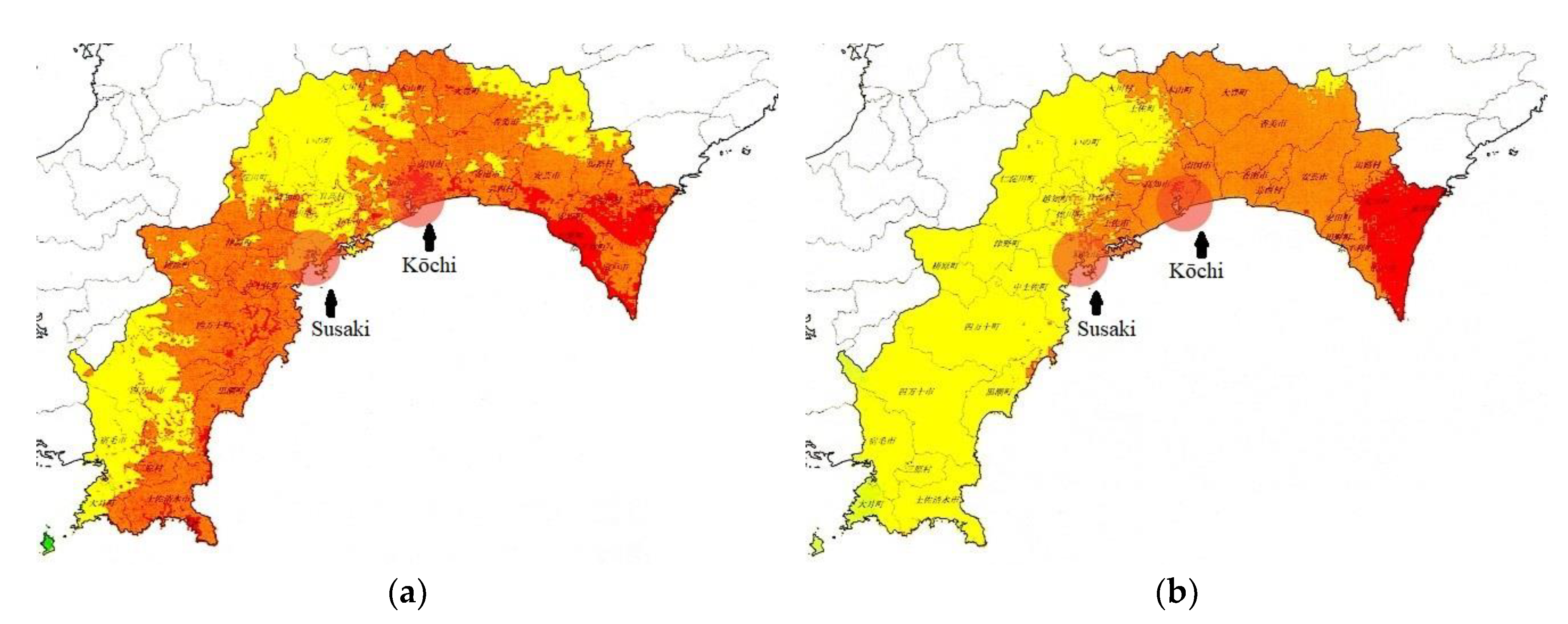
Kōchi is the largest but least populous of Shikoku’s four prefectures and is located on the south coast of the island. According to the latest estimates [48,49], during the next Nankai earthquake, 26 municipalities in the prefecture will suffer from level 6+ or 7 shocks, and the other 8 from level 6 shocks, with the maximum seismic activity lasting from two to three minutes (Figure 2). A rather conservative estimate issued in 2004 presumed that 15% of the built environment of the prefecture would be destroyed and 2.5% of the population injured immediately or within 24 h. Even considering the relatively low density of the area, this means the next Nankai earthquake will destroy 150,000 buildings, kill 10,000 people, hurt another 10,000, and force hundreds of thousands to evacuate [48,49].
All of the 1445 planned evacuation points are ready, 111 out of 115 evacuation towers have been built, and the shelters in the area that will be reached by the tsunami in just three minutes are complete [48,49]. In the capital of the prefecture, there are buildings tall enough and strong enough to serve as evacuation points. There is still a lot to be done in the field of communicating risk as well as increasing autonomous preparedness, not only about the fact that the tsunami will make landfall, but that the water will remain for days, weeks, or months [50].
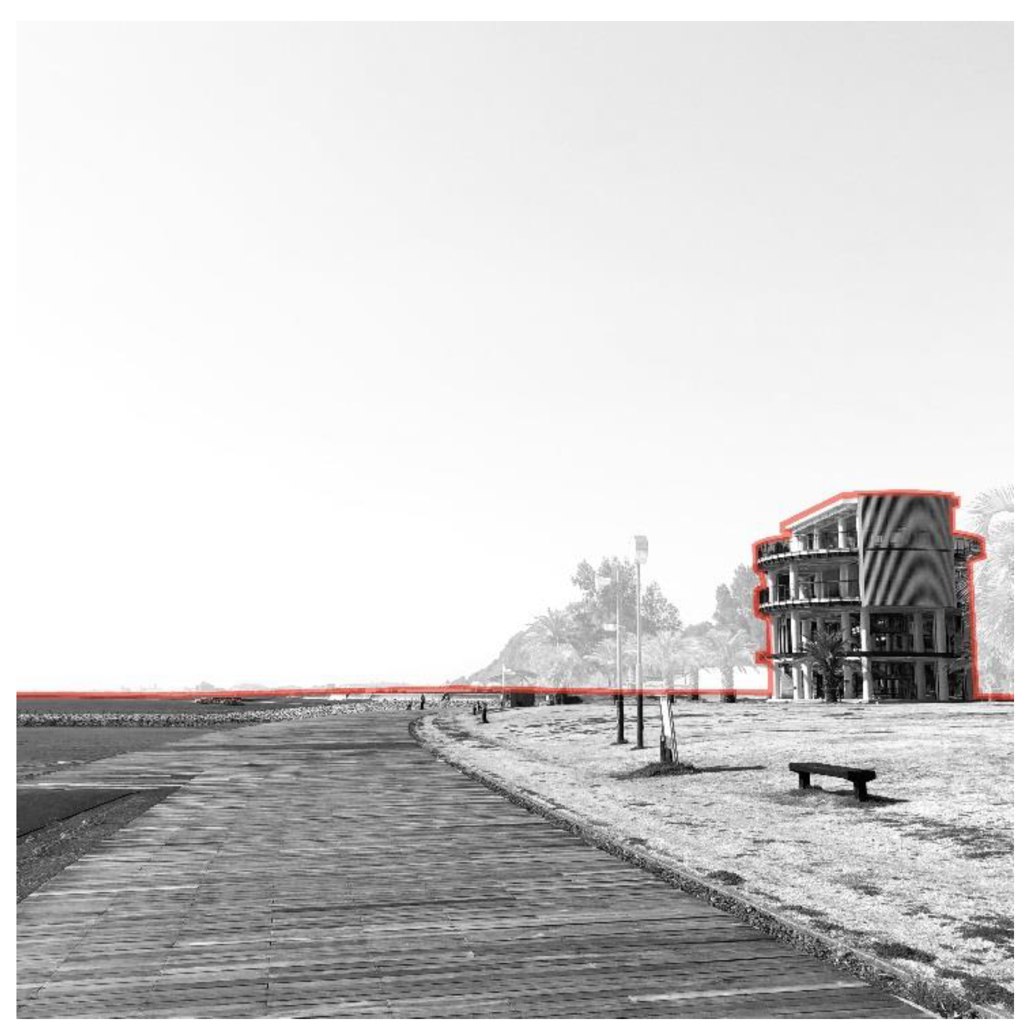
As the first thing to be done, it is a matter of utmost importance to analyze whether the means already provided are actually sufficient and efficient and whether they will remain so in the future. Evacuation towers spread out as a sort of unfinished, obsolete version of Follies designed by Bernard Tschumi for the La Villete park in Paris in the 1980s changed both the rural flatland and the coastal skyline (Figure 3). Extremely rigid in structure, both literally and figuratively speaking, they seem a wasted opportunity, as it may be extremely difficult to turn them into dual spaces a posteriori or to modify them should their capacity or efficiency be rated negatively. This is connected to the economy and demography of the region and the future of small towns such as Susaki, which are vulnerable and in danger of disappearing soon.
3.3. Uncertainty and Mobility: A Susaki City Case Study
Susaki is a small coastal city less than 40 km to the southwest of Kōchi, the capital of the prefecture of the same name. The area was once an active fishing industry center. Unfortunately, this sector, along with all related economy, has been in a constant decline for the last 30 years. Today, the economy has become stagnant, the society is aging, and the clock measuring the time remaining to prepare for the next Nankai earthquake is already in the red.
The seismic hazards in the area are evenly estimated as level 6 and 6+. The maximum shocks will last two to three minutes, and a tsunami measuring 10 to 15 m in height will make landfall in approximately 15 m. It will take another 10 s to flood half of the city’s old district and yet another 10 m to cover the rest of it (Figure 4 and Figure 5). In comparison to the other parts of the prefecture, these are not the most terrifying of estimates, but they are more than alarming, especially when combined with other vulnerabilities of the area.
The urban tissue of the old district, which is the most exposed, may seem regular and basically orthogonal, but its boundaries are not. If it were compared to a circle, 240 degrees of its diameter would be surrounded by water, which changes the perception of space and direction significantly.
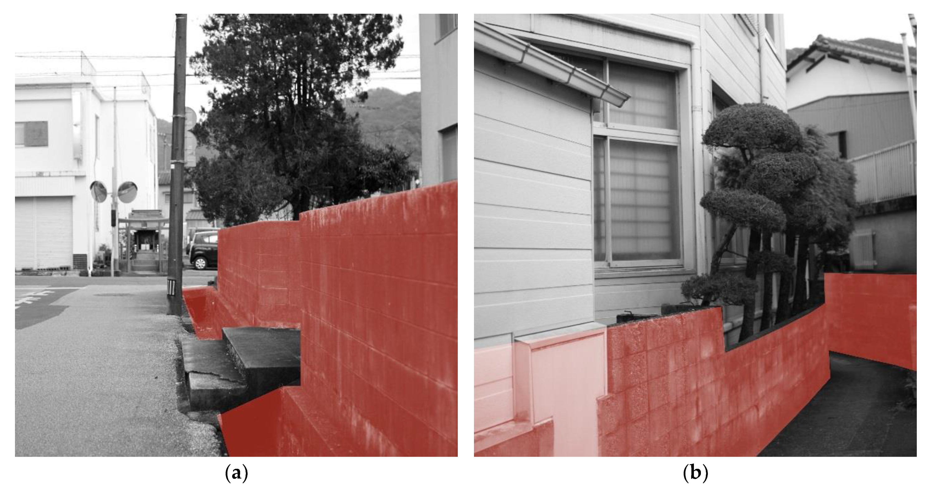
Susaki, as with many villages and small towns in Japan that are suffering from a declining economy as well as a shrinking and aging population, seems a “post-place where all sense has been replaced by the lack of profitability” [25]. There are many empty houses in the area, even though the city has been subsidizing their demolition. Some streets are meandering, and many of them are narrow (with some extremely narrow passages), lined by open sewers and vulnerable enclosures (Figure 6a,b) that could collapse immediately during even moderate shocks. They are still prevalent in the city’s landscape regardless of the efforts of the local authorities and will impede evacuation during and after the earthquake way before the tsunami will make landfall.
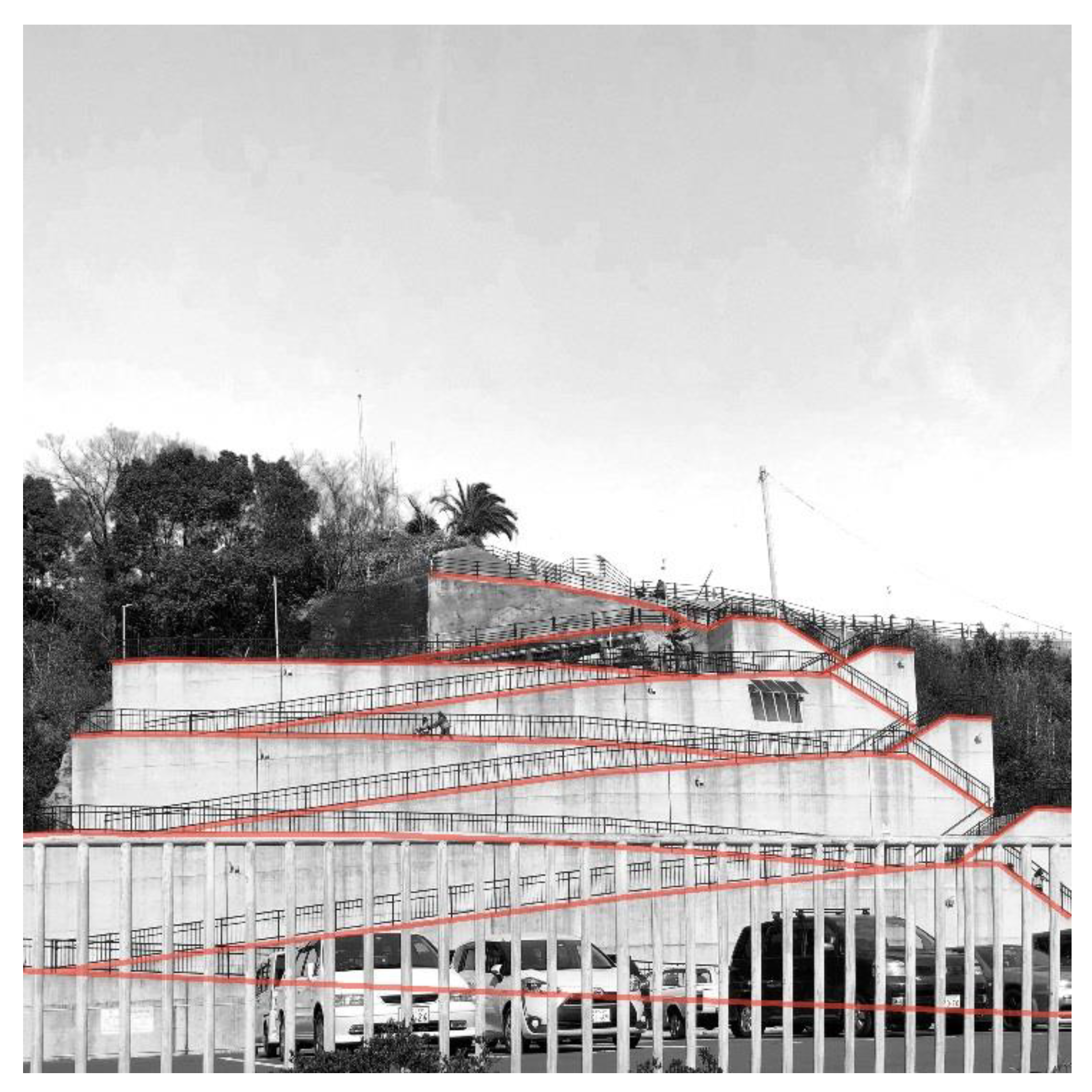
Apart from the evacuation tower in the central area, which is in an advanced phase of construction (Figure 7), basic countermeasures have already been provided, including an evacuation hill (Figure 8 and Figure 9), flood control dams and blockheads, railings to keep trains and heavy infrastructure from floating away toward buildings, etc. Local authorities, benefiting from top-down support, are organizing evacuation drills, disaster assimilation camps, community disaster mitigation units, etc. As mentioned before, they are also subsidizing the reinforcement or demolition of vulnerable structures as well as solutions for making houses and apartments more secure. Unfortunately, these actions and interventions overlap with everyday life instead of aiming to become part of it.
The 2019 edition of the workshop shed some light on the vulnerability of two groups: foreigners and young mothers with newborns. The first were young men from the Philippines coming to Susaki for a three year training program. Interviews held by the students, who were foreigners themselves, revealed that despite being familiar with the nature of the danger (as the Philippines suffers from many natural disasters, earthquakes and tsunamis included) or Japan being at high risk in general, they knew nothing or very little of the local situation. They spoke English, but very little Japanese, and they were unable to read it. They dedicate their entire time to work, and they know only one way through the town: from home to the workplace, with an alternative route to the nearest grocery store.
3.4. Urban Acupuncture: Punctual Treatments
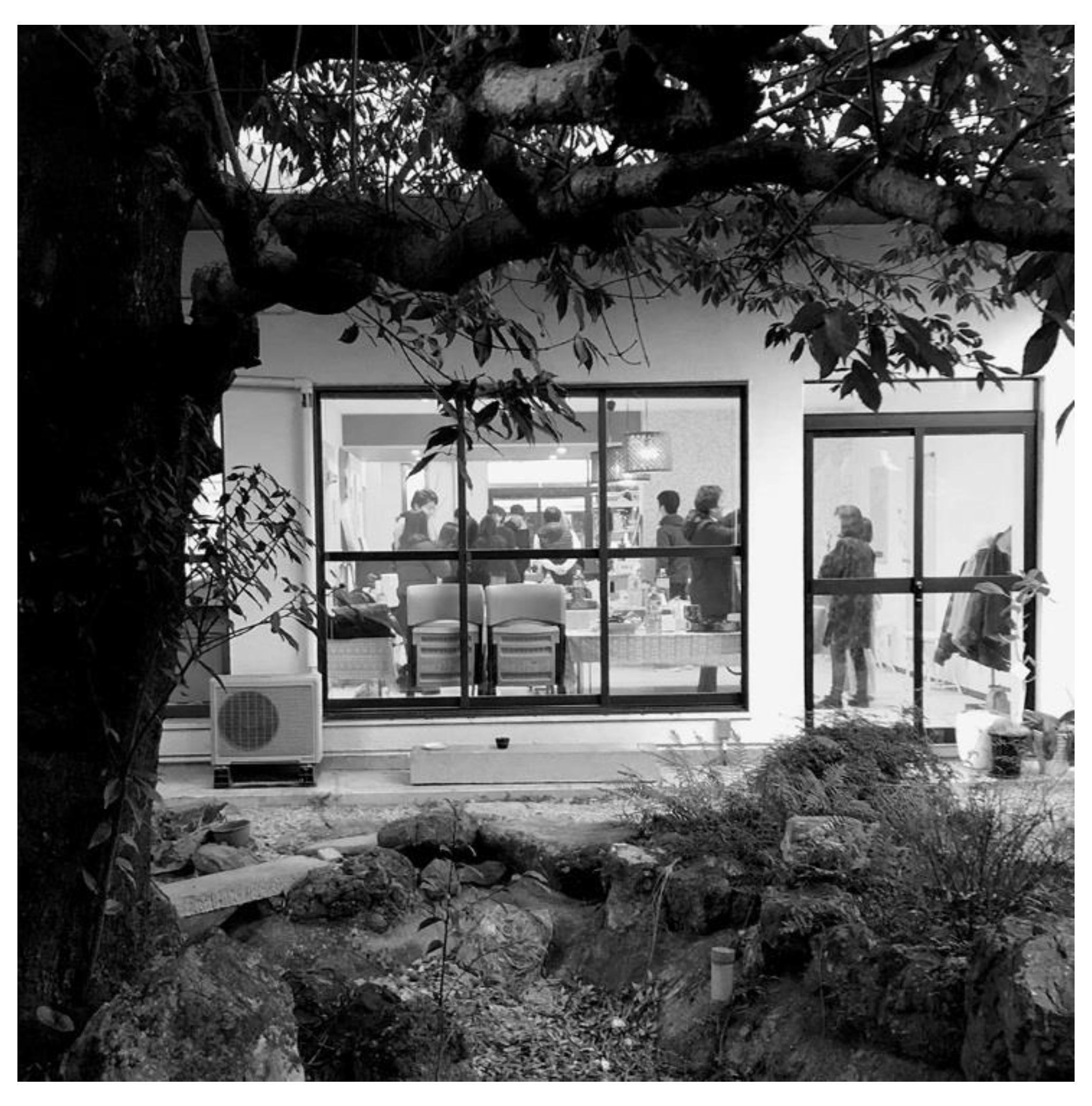
Sometimes small, low-cost interventions may have an immediate impact on everyday life. In the process of creating a network of dual places and walkable spaces, they can be of different types, scales, and measures, and can be applied at different levels of the network itself [51]. As a result of preliminary research, a wheelchair stock at the foot of the evacuation hill (Figure 8) was provided, and some modifications were made to the list of items stocked at the evacuation points (Figure 10). They were both examined during the first and second PREPARe workshops held in Susaki. Drills, walks, and exercises of mapping both risks and vulnerabilities as well as strong points and potentialities have become common activities since then. A former hospital was turned into a cafe and a community center (Figure 11). However, a lot has to be done to improve inclusiveness and adaptability of the key points of the evacuation plan as well as the quality of life: life as it is today, and what it will be during and after a disaster.
The vulnerability of the urban issue derived from the presence of many empty buildings can be turned into an advantage. Some of them can be demolished, allowing new spatial and functional relationships between existing landmarks to be established, and others can be dedicated to low-cost activities or low-profile cultural spots. Finally, a new place for young mothers could be provided in the proximity of the nursery and evacuation tower, as the current one is but a room in a city office building in the new district. The evacuation hill and evacuation points can be turned into free-time recreational spots, with natural playgrounds integrated with a picnic area and wood storage but also preferably with sanitary services and a furoya, for its current state offers but an absolute minimum of a flat asphalted area at a certain level above the sea (Figure 10).
Such a network would not only be a potential improvement of the quality of life, but also would open possibilities for the diversification and revival of the local economy through a “visit-eat-buy” policy. Given the beauty of the region, its clean ocean, its picturesque seashore, the many available empty properties, the excellent food, and reasonable prices in comparison to the most popular Japanese destinations, etc., slow tourism may be an option. However, unless addressed properly, this would bring yet another vulnerable group into the equation. Hence, the universality of the public spaces and evacuation routes should not only derive from their quality as walkable spaces, but also from the language(s) used to transfer knowledge and increase awareness of a possible threat. Kawaii aesthetics commonly applied may not be enough, as instructions are usually in Japanese. Relying on mobile phones and portable translators in the matter seems far too optimistic. It would be much easier to start with the utmost primary type of human activity in the environment: walking and exchanging goods, feelings, and experiences.
3.5. Walkable Distance in the Context of Risk
For humans, short and effortless walkable distances fit within the range of our senses, which is more or less 100 m [15,39,52]. Anything further depends on velocity, which subsequently depends on many other factors, including age and individual abilities. The preferred walking speed of a child (or a flâneur) is ~2 km/h, while the preferred walking speed of an adult is <5 km/h. Walking faster than 5 km/h, unless we are trained, cannot be maintained for too long, even if we are running away from danger, or, as a Kōchi prefecture study revealed [49], especially if we are running away from danger. As a result, walkable distances in everyday life and in case of emergency are different (Table 3). Furthermore, in the case of emergency and evacuation, it is the effective walkable distance that counts. In terms of minutes and meters, they are not only shorter than under normal circumstances [53], but may be subsequently shortened by the very nature of the danger [54,55]. The average escape speed, depending on age and time of evacuation, be it night or day, measured and estimated by the Kōchi Prefecture Section for Countermeasures for the Nankai Trough Earthquake, is surprisingly low in comparison to the average walking speed. Furthermore, it was estimated for flat surfaces only.
The stairs leading to the evacuation hill (Figure 8) are 85.7 m long, and it takes approximately 1′40″ for a healthy adult to climb them under normal circumstances. The slope is 266.3 m long, and it takes 3′30″ for a healthy adult to climb it under normal circumstances, unless drawing a wheelchair. If we compare these distances to the walkable range presented in Table 3, the evacuation hill may be too far away to be reached and climbed in time.
- Walkable Distances in Everyday Life and in the Case of Emergency
- In everyday life, the walkable range depends on individual capacities and attributes (health, age, etc.), as well as external factors (weather, barriers, inclines, etc.).
- In case of an emergency, the walkable range depends on individual capacities, attributes, and vulnerabilities (health, age, abilities, knowing/not knowing the way, etc.); external factors and vulnerabilities (weather, visibility, time of day, barriers, obstacles); things to carry (a baby, an oxygen concentrator, etc.); people who need to be attended to and/or carried; properties of the evacuation route; collapsed buildings and infrastructure; information; and the nature of the danger, in particular its scale and the time available before it strikes.
- Effective Walkable Distances in the Face of Danger
- (S) Evacuation is immediate: evacuation points or secure places are in close proximity; and individual, external, and hazard factors are irrelevant to evacuation (“I’m sure I’m going to make it”).
- (M) Evacuation is relatively fast and easy; individual, external, and hazard factors have an impact on length, effort, etc.; and weak points and vulnerabilities should be addressed in order to reach a net walkable distance (“I’m going to make it”).
- (L) Evacuation is difficult and/or requires effort; individual, external, and hazard factors may impede it significantly; and weak points and vulnerabilities must be addressed in order to secure an evacuation (“I’m going to make it, am I not…?”).
- (XL) Evacuation is very difficult or impossible, and new solutions must be provided or some elements and/or negative factors eliminated (“I’m not going to make it, am I…?”).
In this context, a network of dual places connected by walkable spaces that invites members of the most vulnerable groups to stay within a walkable range of evacuation points is necessary—not through force or a drill but voluntarily, as result of opportunities offered by high-quality public spaces.
4. Discussion
Worldwide, the need for evacuation routes and points results in infrastructural interventions in which pedestrians are limited to their numbers and the square feet necessary to meet the fact of their very presence or their basic activities. There are no consolidated strategies for historical city centers and dense areas that integrate sustainable development and evacuation plans. The dual dimension of public spaces, derived from their capacity to fulfill the needs of everyday life and an adaptation to emergency situations, is not emphasized enough in the discourse deriving from either the field of compact cities and walkability or risk mitigation. As the case study of Susaki City presented in this paper revealed, future research directions should focus on the complexity of relations between networks of walkable spaces, evacuation plans, urban structures, and inclusiveness in order to meet the criteria of adaptable, sustainable, and resilient design.
In everyday life or after having faced trauma, being able to go out for a walk can change a lot. All vulnerabilities and potentials that natural hazards bring to light (the decline/beauty of the landscape (including the third one [32]), the obsolescence/importance of infrastructure, indifference to or denial of risk/awareness, the devastation/value of cultural heritage, a depopulation/population influx, commuting/migration [56], etc.) can be approached while applying measures and methods derived from the concept of walkability. Adaptability, resilience, and dual spaces are not about aesthetics. However, they do not exclude an interest in beauty and pleasure in the surroundings.
Designs for risk reduction require planning with the public instead of planning for the public [44] and also planning with risk instead of planning against risk [1,57]. Since awareness, responsibility, and resilience cannot be enhanced and change cannot be embraced [24] without embracing the territory [1], shared walkable places (extending to the shared walkable territory) are the key to participatory processes oriented toward natural risk management and mitigation. In the case of disaster mitigation, punctual treatment is often the only solution on the table. Unfortunately, it cannot be assumed to be efficient without the entire system being taken into consideration. Small treatments, including expensive ones, will not prevail against large-scale vulnerability.
It is not true that “First Things” must be addressed “First”, and the issue of making them useful in everyday life, or at least maintainable, can wait. Evacuation points and routes should be walkable and dual from day one. Sustainability, adaptability, resilience, universality, and walkability are all faces of the same coin and should be considered intrinsic to any disaster mitigation-oriented action. The criteria of walkability and a hybrid quantitative–qualitative approach to design for risk reduction, evacuation routes, and evacuation plans included, could have a significant impact on the efficiency of all strategies for adaptation under deep uncertainties, from pre-disaster preparedness to post-disaster rescue, relief, recovery, and (re)construction [1,56,58,59,60].
Walkability can and should be part of autonomous adaptation, individual resilience, community resilience, preparedness, evacuation, recovery, and reconstruction. Designing dual walkable spaces in the context of natural hazards, something that, given the consequences of climate change, may soon apply to all but the larger parts of the built environment, requires competence in many fields, as those spaces have to be truly flexible, accessible, inclusive, and adapted (as well as adaptable) to extreme conditions (c.f. tsunami evacuation towers). Future studies should be focused on making design guidelines simpler, or at least more comprehensible, in order to simplify their application in decision-making processes.
The intention of this paper was to explain why evacuation routes should be traversed as any other preferred route: for everyday purposes, for pleasure, in search of health and a sense of belonging, to make acquaintances, and to bond with the surroundings. The intention was also to emphasize the complexity and challenges of designing walkable spaces in the context of risk. In the zero-sum applied to disaster mitigation plans, dual walkable evacuation points and routes may prove to be cheaper and more efficient, as a dual evacuation point can bring profit instead of generating costs, etc., along with non-direct, subjective benefits that should not be underestimated.
Author Contributions
Conceptualization, A.P. and P.R.; methodology, S.O., A.P., P.R., M.S.; investigation, S.O., A.P., P.R., M.S.; supervision, P.R.; writing—original draft preparation, A.P.; writing—review and editing, A.P., P.R.; visualization, A.P.
Funding
This research received no external funding.
Conflicts of Interest
The authors declare no conflict of interest.
References
- Porębska, A.; Rizzi, P. Urban Acupuncture: Dual Spaces as a Strategy for Urban Resilience. In Nano, Bio, Green and Space: Technologies for a Sustainable Future. Proceedings of the SGEM International Multidisciplinary Scientific Geoconference, Vienna, Austria, 27–29 November 2017; STEF92 Technology Ltd.: Sofia, Bulgaria, 2017; Volume 17, pp. 827–834. ISBN 9786197408294. [Google Scholar] [CrossRef]
- Konstytucja Rzeczypospolitej Polskiej z dnia 2 kwietnia 1997, Dz.U. 1997 nr 78 poz. 483. Available online: http://prawo.sejm.gov.pl/isap.nsf (accessed on 1 October 2018).
- 1950 European Convention on Human Rights; European Court of Human Rights, Council of Europe. Available online: www.echr.coe.int/Documents/Convention_ENG.pdf (accessed on 1 October 2018).
- 1948 Universal Declaration of Human Rights, General Assembly Resolution 217A. Available online: www.un.org/en/universal-declaration-human-rights/ (accessed on 1 October 2018).
- World Commission on Environment and Development. Our Common Future; Oxford University Press: Oxford, UK, 1987. [Google Scholar]
- 2012 UN-Habitat, General Assembly Resolution 67/216. Available online: unhabitat.org/wpdm-package/resolution-adopted-by-the-general-assembly-ares67216-implementation-of-the-outcome-of-the-united-nations-conference-on-human-settlements-habitat-ii-and-strengthening-of-the-united-nations-huma/ (accessed on 10 October 2018).
- Human Rights: A Reality for All. Council of Europe Disability Strategy 2017–2023. Available online: http://edoc.coe.int (accessed on 2 February 2018).
- 2006 Convention on the Rights of Persons with Disabilities, UN General Assembly Resolution 61/06. Available online: www.un.org/disabilities/documents/convention/convention_accessible_pdf.pdf (accessed on 1 September 2018).
- Goldsmith, S. Designing for the Disabled, 1st ed.; RIBA Publications: London, UK, 1963; ISBN 9780080572802. [Google Scholar]
- Goldsmith, S. Designing for the Disabled: The New Paradigm, 1st ed.; Architectural Press: Oxford, UK, 1997; ISBN 978-0900630507. [Google Scholar]
- Story, M.F.; Mueller, J.L.; Mace, R.L. The Universal Design File: Designing for People of All Ages and Abilities, revised ed.; North Carolina State University: Raleigh, NC, USA, 1998. [Google Scholar]
- Goldsmith, S. Universal Design: A Manual of Practical Guidance for Architects, 1st ed.; Architectural Press: Oxford, UK, 2000; ISBN 075064785X. [Google Scholar]
- Resolution Res/AP/2001/1 on the Introduction of the Principles of Universal Design into the Curricula of All Occupations Working on the Built Environment Adopted by the EU Committee of Ministers on 12 February 2001. Available online: rm.coe.int/16805a2a1e (accessed on 2 November 2014).
- Universal Design: Clarification of the Concept, The Norwegian Ministry of the Environment: Oslo, Norway, 2007. Available online: www.universell-utforming.miljo.no/file_upload/udclarification.pdf (accessed on 2 November 2014).
- Porębska, A.E. Spaces of Solitude: People and Places in Deadened Cities. Ph.D. Thesis, University of Sassari, Sassari, Italy, 4 March 2016. [Google Scholar]
- Ewing, R.; Handy, S. Measuring the Unmeasurable: Urban Design Qualities Related to Walkability. J. Urban Des. 2009, 14, 65–84. [Google Scholar] [CrossRef]
- Meerow, S.; Newell, J.P.; Stults, M. Defining Urban Resilience: A review. Landsc. Urban. Plan. 2016, 147, 38–49. [Google Scholar] [CrossRef]
- Holling, C.S. Resilience and Stability of Ecological Systems. Annu. Rev. Ecol. Evol. Syst. 1973, 4, 1–23. [Google Scholar] [CrossRef] [Green Version]
- Godschalk, D.R. Urban Hazard Mitigation: Creating Resilient Cities. Nat. Hazards Rev. 2003, 4, 136–143. [Google Scholar] [CrossRef]
- Klein, R.J.T.; Nicholls, R.J.; Thomalla, F. Resilience to Natural Hazards: How useful is this concept? Environ. Hazards 2003, 5, 35–45. [Google Scholar] [CrossRef]
- Walker, B.; Salt, D. Resilience Thinking: Sustaining Ecosystem and People in a Changing World; Island Press: Washington, DC, USA, 2006. [Google Scholar]
- Walker, W.E.; Haasnoot, M.; Kwakkel, J.H. Adapt or Perish: A Review of Planning Approaches for Adaptation Under Deep Uncertainty. Sustainability 2013, 5, 955–979. [Google Scholar] [CrossRef]
- UNISDR. Natural Disasters and Sustainable Development: Understanding the Links between Development, Environment and Natural Disasters. May 2002. Available online: https://www.unisdr.org (accessed on 10 March 2019).
- Vale, L.J.; Campanella, T.J. The Resilient City: How Modern Cities Recover from Disaster; Oxford University Press: Oxford, UK, 2004; ISBN 9780195175837. [Google Scholar]
- Toffler, A. Future Shock; Random House: New York, NY, USA, 1970; ISBN 0394425863. [Google Scholar]
- Burton, I. Climate Change and the Adaptation Deficit. In The Earthscan Reader on Adaptation to Climate Change; Schipper, E.L.F., Burton, I., Eds.; Earthscan: London, UK, 2009. [Google Scholar]
- Dewar, J.A. Assumption-Based Planning: A Tool for Reducing Avoidable Surprises; Cambridge University Press: Cambridge, UK, 2002. [Google Scholar]
- Tonkiss, F. The Ethics of Indifference: Community and Solitude in the City. Int. J. Cult. Stud. 2003, 6, 297–311. [Google Scholar] [CrossRef]
- Wakayama Prefecture. Survey on Earthquake and Tsunami Risk Awareness 2005. Available online: http://www.pref.wakayama.lg.jp/prefg/011400/bousai/050415/top.html (accessed on 20 June 2018). (In Japanese).
- Sun, Y.; Yamori, K. Risk Management and Technology: Case Studies of Tsunami Evacuation Drills in Japan. Sustainability 2018, 10, 2982. [Google Scholar] [CrossRef]
- Ingold, T. The Perception of the Environment: Essays on Livelihood, Dwelling and Skill; Routledge: London, UK, 2000; ISBN 9780415228312. [Google Scholar] [CrossRef]
- Clément, G. Manifeste du Tiers Paysage; Sujet-Objet: Paris, France, 2004; ISBN 9782914981026. [Google Scholar]
- Japan Women’s Network for Disaster Risk Reduction. Japanese Women’s Perspective on 3/11 (2013). Available online: http://preventionweb.net (accessed on 15 November 2015).
- Women as a Force for Change. Gender Equality and Disaster Mitigation. Available online: http://jwndrr.org/main/wp-content/uploads/2015/08/Report_qatar_final.pdf (accessed on 20 April 2019).
- Loneliness in Later Life: Evidence Review, 2015. Available online: http://www.ageuk.org.uk (accessed on 10 October 2015).
- McDaniel, R.R.; Driebe, D.J. Uncertainty and Surprise in Complex Systems: Questions on Working the Unexpected; Springer: Berlin, Germany, 2005. [Google Scholar]
- IISD. Designing Policies in a World of Uncertainty. Change and Surprise—Adaptive Policy-Making for Agriculture and Water Resources in the Face of Climate Change—Phase I Research Report; International Institute for Sustainable Development: Winnipeg, MB, Canada, 2006. [Google Scholar]
- Collins, A.E.; Jones, S.; Manayena, B.; Jayawickrama, J. Hazards, Risk and Disasters in Society; Elsevier: Oxford, UK, 2014; ISBN 9780123964519. [Google Scholar]
- Gehl, J. Cities for People; Island Press: Washington, DC, USA, 2010; ISBN 9781597265737. [Google Scholar]
- Klabbers, J. The Magic Circle, 3rd ed.; Sense Publishers: Rotterdam, The Netherlands, 2009; ISBN 9789087900069. [Google Scholar]
- Rizzi, P. Giochi di città: Manuale per imparare a vivre in una comunità equa e sostenibile; La Meridiana: Molfetta, Italy, 2004; ISBN 9788889197202. (In Italian) [Google Scholar]
- Rizzi, P.; Marcia, A.; Denti, B.; D’Ascanio, F. Strumenti di supporto a territori fragili e vulnerabili: Dal giocosimulazione al Piano di Protezione Civile. Urb. Inf. 2017, 272, 307–310. (In Italian) [Google Scholar]
- Diver-s-City Urban Lab. Available online: http://diver-s-city.sdvb9.net (accessed on 8 May 2019).
- Healey, P. Collaborative Planning: Shaping Places in Fragmented Societies; UBC Press: Vancouver, BC, Canada, 1997; ISBN 0774805978. [Google Scholar]
- Cabinet Office. Report on Estimates of the Distribution of Seismic Intensity and the Height of Tsunami Waves of Nankai Trough Earthquake. 31 March 2012. Available online: http://bousai.go.jp/jishin/nankai/model/ (accessed on 1 June 2014). (In Japanese)
- EERI. Earthquake Engineering Research Institute. The Great East Japan Earthquake and Tsunami: Social Dimension. Special Report. Available online: http://www.eqclearinghouse.org/2011-03-11-sendai/files/2011/03/Japan-SocSci-Rpt-hirez-rev.pdf (accessed on 1 March 2019). (In Japanese).
- National Policies for Japanese Cities. Available online: http://blog.mipimworld.com/2012/09/national-policies-for-japanese-cities/ 6 September 2012 (accessed on 30 May 2018). (In Japanese).
- National Police Agency of Japan. Tohoku Earthquake Tsunami Damage and Police Measures. 10 April 2014. Available online: http://www.npa.go.jp/archive/keibi/biki/higaijokyo.pdf (accessed on 1 June 2014). (In Japanese)
- Nakano, T.; Section for Countermeasures for Nankai Trough Earthquake, Kochi Prefecture; Taniwaki, H.; Disaster Prevention Section, Susaki City Office. Personal communication, 2nd International Spring School PREPARe, Susaki. 18 February 2019.
- Tsunami Hazard Map (Depth and Wave Arrival Time) and Seismic Hazard Map for Susaki City. Available online: bousaimap.pref.kochi.lg.jp/kochi/map (accessed on 28 March 2019).
- Rizzi, P.; Denti, B.; Marcia, A.; Promsaka Na Sakronnakron, S. Dual Spaces_Resilient Spaces: Risk Awareness and Responsibility. In Proceedings of the RRRC 2016 Conference, Bucharest, Romania, 3–4 November 2016; UAUIM: Bucarest, Romania, 2016. ISBN 9786066381550. [Google Scholar]
- Hall, E.T. Hidden Dimension; Doubleday: Garden City, NY, USA, 1966; ISBN 9780385084765. [Google Scholar]
- Zhu, X.; Sun, B. Study on earthquake risk reduction from the perspectives of the elderly. Saf. Sci. 2017, 91, 326–334. [Google Scholar] [CrossRef]
- Bacon, P.; Hobson, C. Human Security and Japan’s Triple Disaster: Responding to the 2011 Earthquake, Tsunami and Fukushima Nuclear Crisis; Routledge: Abingdon, UK, 2014; ISBN 9781138013131. [Google Scholar]
- Read, J.K.; Norris, F.H.; Ruback, R.B. Predicting evacuation in two major disasters: Risk perception, social influence, and access to resources. J. Appl. Soc. Psychol. 1999, 29, 918–934. [Google Scholar] [CrossRef]
- Rizzi, P.; Marcia, A. Spazi duali_spazi resilienti: Essere consapevoli e responsabili nel rischio. In Disegnare le dinamiche del territorio. Trasferimento tecnologico e informazione territoriale; Cicalò, E., Ed.; Franco Angeli: Milan, Italy, 2015; ISBN 9788891728371. [Google Scholar]
- de Graaf, R. Four Walls and a Roof: The Complex Nature of a Simple Profession; Harvard University Press: Cambridge, MA, USA, 2017; ISBN 9780674976108. [Google Scholar]
- OECD Report. L’azione delle politiche a seguito dei disastri naturali: Aiutare le regioni a sviluppare la resilienza—il caso dell’Abruzzo posst-terremoto; OECD Publishing: Paris, France, 2013. (In Italian) [Google Scholar] [CrossRef]
- Reconstruction Design Council. Towards Reconstruction: Hope beyond the Disaster, 2011. Available online: http://www.reconstruction.go.jp/topics/2011/06/000084.html (accessed on 10 March 2019). (In Japanese)
- GFDRR World Bank Report. The Great East Japan Earthquake—Learning from Mega Disasters: Knowledge Notes; World Bank: Washington, DC, USA, 2012; Available online: https://openknowledge.worldbank.org (accessed on 1 March 2019).
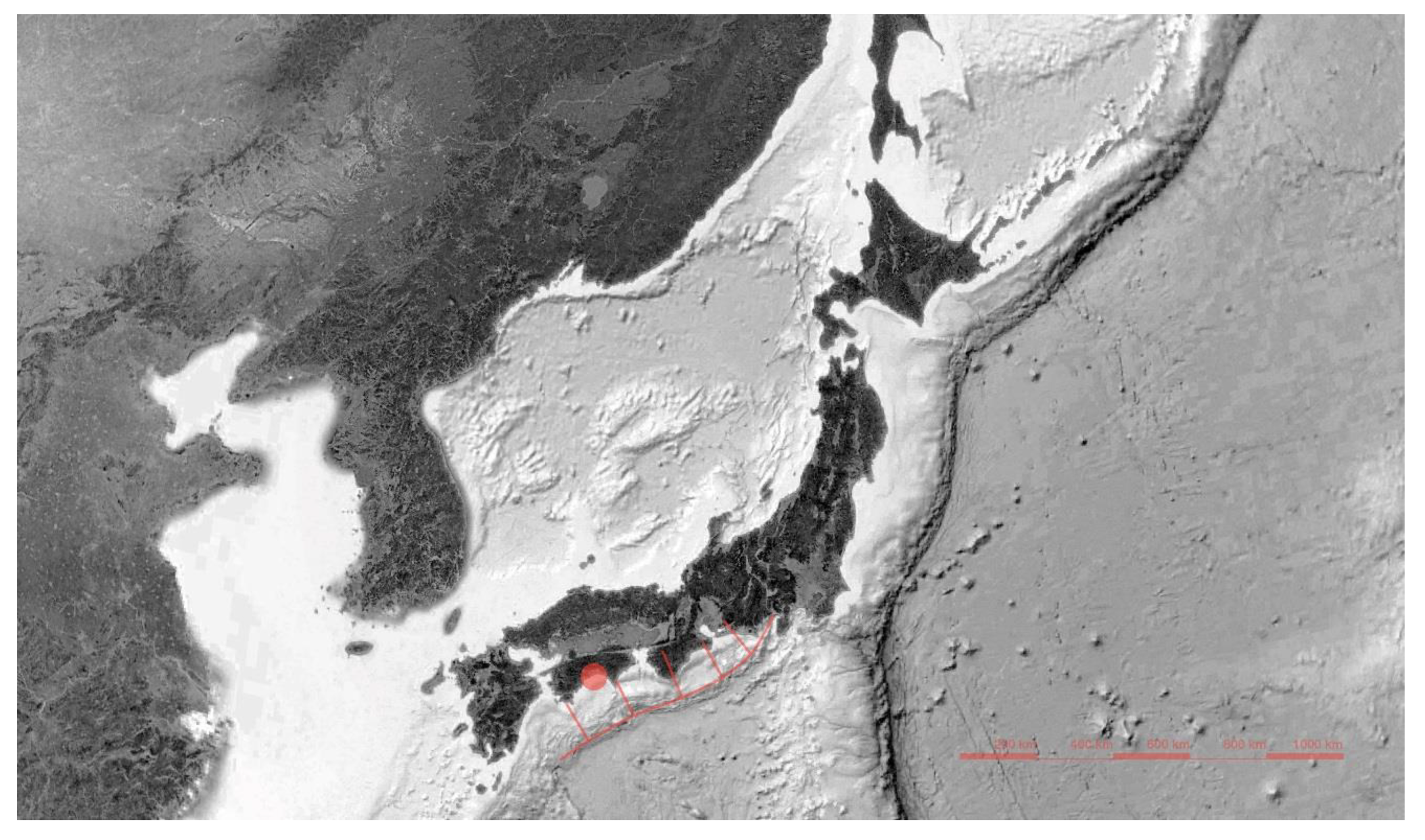
Figure 1.
Japanese archipelago and the Japan Trench as seen from orbit (data: SIO, NOAA, U.S. Navy, NGA, GEBCO, Google Earth; 25°44′ N–45°28′ N, 109°16′ E–157°36′ E). The Nankai megathrust and the area of Kōchi and Susaki are marked red.
Figure 1.
Japanese archipelago and the Japan Trench as seen from orbit (data: SIO, NOAA, U.S. Navy, NGA, GEBCO, Google Earth; 25°44′ N–45°28′ N, 109°16′ E–157°36′ E). The Nankai megathrust and the area of Kōchi and Susaki are marked red.

Figure 2.
Estimates for the upcoming Nankai earthquake for Kōchi Prefecture: (a) 6+ and 7 on the shindo scale, meaning people are unable to stand or walk without crawling, are marked orange and red, correspondingly; (b) the length of maximum shocks in minutes. The cities of Susaki and Kōchi are marked [49].

Figure 3.
Typical element of the Shikoku coastal skyline: an evacuation tower in Yosa, Kōchi Prefecture (photo by A. Porębska, February 2019).
Figure 3.
Typical element of the Shikoku coastal skyline: an evacuation tower in Yosa, Kōchi Prefecture (photo by A. Porębska, February 2019).

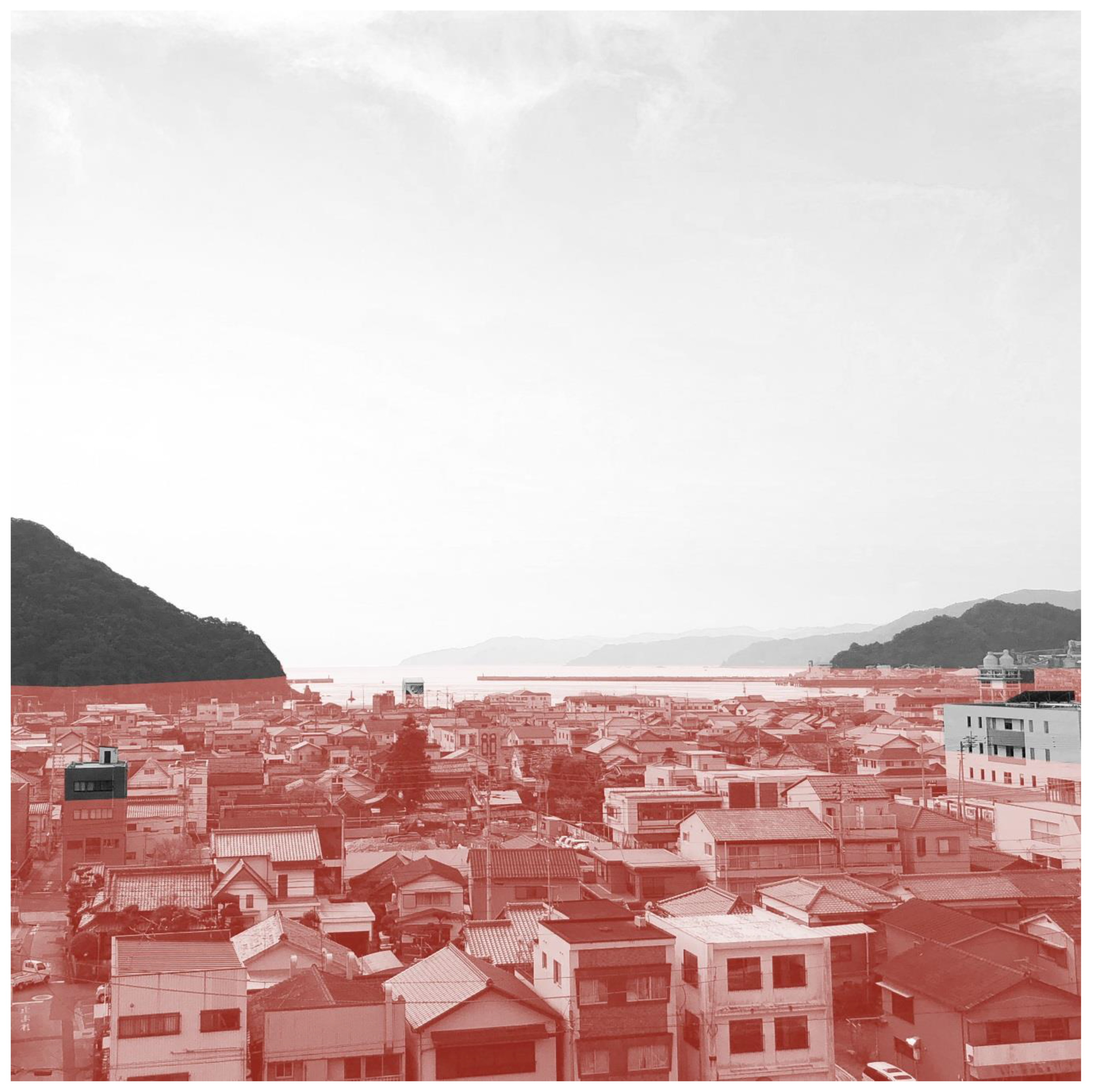
Figure 4.
Susaki: a view of the old district and the ocean from the evacuation hill. Graphic simulation of the predicted tsunami height [50] (photo by A. Porębska, February 2019).
Figure 4.
Susaki: a view of the old district and the ocean from the evacuation hill. Graphic simulation of the predicted tsunami height [50] (photo by A. Porębska, February 2019).

Figure 5.
Susaki city: the old district and port. Existing evacuation points and the urban area at risk of flooding according to official data [50]. Position of figures marked red: Figure 6a. Typical street view: Figure 6b. Typical narrow passage: Figure 7. Evacuation tower: Figure 8. Evacuation hill: Figure 9a. Route toward the evacuation point: Figure 9b. Path from the evacuation point toward the north: Figure 10. Evacuation point: Figure 11. ChuChuman Cafe.

Figure 6.
Susaki city: vulnerable elements in narrow streets. (a) Vulnerable walls along open sewers; (b) vulnerable walls along narrow, curved passages (photo by A. Porębska, February 2019).
Figure 6.
Susaki city: vulnerable elements in narrow streets. (a) Vulnerable walls along open sewers; (b) vulnerable walls along narrow, curved passages (photo by A. Porębska, February 2019).

Figure 7.
Evacuation tower under construction (photo by A. Porębska, February 2019).

Figure 8.
Evacuation hill and its climb, starting at 5 m a.c.s.l. and reaching 31 m a.c.s.l. The stairs are 85.7 m long, and in normal circumstances it takes approximately 1′40″ for a healthy adult to climb them. The slope is 266.3 m long, and in normal circumstances it takes 3′30″ for a healthy adult to climb it, unless drawing a wheelchair. Currently, official average evacuation speeds for evacuation plans are estimated only for flat surfaces (photo by A. Porębska, February 2019).

Figure 9.
Susaki evacuation point: (a) route along Joyama Park leading from the evacuation hill (Figure 8) to the evacuation point (Figure 10). The path is 257 m long and too narrow for a standard ambulance to pass (photo by A. Porębska, February 2019). (b) Route from the evacuation point (Figure 10) toward the north (photo by A. Porębska, February 2019).

Figure 10.
Students and teachers of the second International Spring School PREPARe preparing to cook lunch at the evacuation point. Currently, the area is just a flat asphalted surface equipped with storage (photo by A. Porębska, February 2019).
Figure 10.
Students and teachers of the second International Spring School PREPARe preparing to cook lunch at the evacuation point. Currently, the area is just a flat asphalted surface equipped with storage (photo by A. Porębska, February 2019).

Figure 11.
ChuChuman Cafe on Furuichi Street: the view from the backyard garden. As a result of the preliminary research held by the Diver-s-City lab, the University of Sassari, Italy, and the University of L’Aquila before the first PREPARe International Spring School, an abandoned building in the old hospital was successfully turned into a local community center and café, creating a new point for the future network of dual spaces (photo by A. Porębska, February 2019).


Table 1.
Last Nankai earthquakes and tsunamis compared to estimates of the upcoming event [49].
Table 1.
Last Nankai earthquakes and tsunamis compared to estimates of the upcoming event [49].
| Event | Date | Magnitude (Richter) | Magnitude (Shindo) | Max. Tsunami Height (m) |
|---|---|---|---|---|
| Tōkai/Nankai | 1854 | 8.4 | 6+ | 28 |
| Tōnankai | 1944 | 7.9 | >5 | 10 |
| Nankai | 1946 | 8.0 | 6+ | 6 |
| Nankai | Expected | 9.0 | 7 | 34 |
Table 2.
Last Nankai and Nankaido earthquakes and tsunamis compared to estimates of the upcoming event (affected population) [49].
Table 2.
Last Nankai and Nankaido earthquakes and tsunamis compared to estimates of the upcoming event (affected population) [49].
| Event | Date | Affected Population | Casualties Dead/Injured | Homeless |
|---|---|---|---|---|
| Tōkai/Nankai | 1854 | n/a | thousands | tens of thousands |
| Tōnankai | 1944 | tens of thousands | thousands/1223 | 57,248 |
| Nankai | 1946 | tens of thousands | thousands/1443 | 36,529 |
| Nankai | Expected | millions | >300,000 | >2,300,000 |
Table 3.
Walkable distance perceptions depending on the context: everyday life versus evacuation. In terms of minutes and meters, walkable distances in the case of evacuation are much shorter than in everyday life and, as the Kochi prefecture case study revealed [49], may be subsequently limited by the very nature of the danger.
| Target Group/Context | Average Speed | Near (S) | Quite Near (M) | Quite Far (L) | Too Far (XL) |
|---|---|---|---|---|---|
| everyday (average) | 1.4 m/s 5 km/h | <2′–5′ 300 m | <30′ <2 km | >30′ >2 km | >1 h >5 km |
| everyday (slow) | 0.55 m/s 2 km/h | <2′–5′ 100 m | <10′ 300 m | >20′ 700 m | >30′ >1 km |
| evacuation (average) daytime | 0.7 m/s 2.5 km/h | <3′ <130 m | <5′ <210 m | >10′ >420 m | >15′ >630 m |
| evacuation (average) night-time | 0.56 m/s 2 km/h | <3′ <100 m | <5′ <170 m | >10′ >340 m | >15′ >500 m |
| evacuation (slow) night-time | 0.42 m/s 1.5 km/h | <3′ <75 m | <5′ <130 m | >10′ >250 m | >15′ >380 m |
| evacuation | individual | I’m there/almost there | I’m going to make it! | I’m going to make it, am I not? | I’m not going make it… |
© 2019 by the authors. Licensee MDPI, Basel, Switzerland. This article is an open access article distributed under the terms and conditions of the Creative Commons Attribution (CC BY) license (http://creativecommons.org/licenses/by/4.0/).
Share and Cite
MDPI and ACS Style
Porębska, A.; Rizzi, P.; Otsuki, S.; Shirotsuki, M. Walkability and Resilience: A Qualitative Approach to Design for Risk Reduction. Sustainability 2019, 11, 2878. https://doi.org/10.3390/su11102878
AMA Style
Porębska A, Rizzi P, Otsuki S, Shirotsuki M. Walkability and Resilience: A Qualitative Approach to Design for Risk Reduction. Sustainability. 2019; 11(10):2878. https://doi.org/10.3390/su11102878
Chicago/Turabian StylePorębska, Anna, Paola Rizzi, Satoshi Otsuki, and Masahiro Shirotsuki. 2019. "Walkability and Resilience: A Qualitative Approach to Design for Risk Reduction" Sustainability 11, no. 10: 2878. https://doi.org/10.3390/su11102878
Note that from the first issue of 2016, this journal uses article numbers instead of page numbers. See further details here.