Research Progress on Changes in Land Use and Land Cover in the Western Himalayas (India) and Effects on Ecosystem Services


1
Key Laboratory of Land Surface Pattern and Simulation, Institute of Geographic Sciences and Natural Resources Research, CAS, Beijing 100101, China
2
University of Chinese Academy of Sciences, Beijing 100049, China
3
CAS Center for Excellence in Tibetan Plateau Earth Sciences, Beijing 100101, China
*
Author to whom correspondence should be addressed.
Sustainability 2018, 10(12), 4504; https://doi.org/10.3390/su10124504
Submission received: 30 September 2018
/
Revised: 21 November 2018
/
Accepted: 27 November 2018
/
Published: 29 November 2018
(This article belongs to the Section Environmental Sustainability and Applications)
Abstract
:Western Himalaya is an important region in terms of its enriched biodiversity and immense ecosystem services (ESS). However, its biodiversity and ESS are under tremendous pressure from rapid population growth, developmental activities, unplanned urbanization, agricultural expansion, climate change, and the associated changes in land use and land cover (LULC). This study provides a systematic review of the composition and pattern of LULC (from existing literature) and the effects of LULC change on various ESS provided by the western Himalayan ecosystems. Despite being such a significant area, data and studies concerning the impacts of LULC change on the spatial distribution of ESS, focused particularly on the western Himalayan region are inadequately reported. Most existing studies indicate a general decrease in forest cover and an increase in forest fragmentation along with generally increasing trends in built-up areas, croplands, and barren lands. These results imply ecosystem degradation and a reduction in the potential for the sustainable flow of ESS from this region. In this respect, this study suggests that quantification and spatial mapping of ESS in the western Himalayan region is conducted.
1. Introduction
Land use refers to the utilization of land for different purposes, whereas land cover indicates the natural and artificial cover on the land surface (e.g., natural vegetation, agriculture, bare earth, water bodies, and man-made structures). Scientists refer to land use as the utilization of land for various human activities, including conservation, development, and mixed uses. On the other hand, land-use and land-cover change (LUCC) refers to the modification of Earth’s terrestrial surface by anthropogenic forces. Although humans have modified land to obtain food and other essential resources for thousands of years, unprecedented LUCC has occurred since the beginning of 20th century. Examples of the extensive changes during this period include a doubling of agricultural land, a four-fold increase in human population, a 14-fold increase in economic production, a 15-fold increase in energy use, and a 17-fold increase in carbon dioxide emissions [1]. LUCC has recently become a major focus area in the global research community [2,3] because of its significant effects on climate change [4,5], biogeochemical cycles [6], ecosystem services (ESS), and biodiversity [7]. LUCC is driven by socio-economic and biophysical phenomena that depend on the spatial location, scale, demographics, political structure, economy, and existing land uses [8,9,10,11,12]. Furthermore, the driving factors of LUCC vary with location and time, making LUCC both spatially and temporally heterogeneous. Therefore, to better understand the human influence on the natural environment, it is essential to investigate the spatial and temporal dynamics of LUCC.
Ecosystem services, which have been defined as benefits that people obtain from ecosystems [13], include provisioning services, regulating services, supporting services, and cultural services. ESS have also been defined as the result of interactions between the biotic and abiotic components of an ecosystem [14]. Lawton defined ESS as the conditions and processes through which ecosystems and the species within them sustain and fulfill human life [15]. Some economists treat ESS as components of nature that are enjoyed, consumed, or used for human well-being [16]. Terrestrial ecosystems provide a number of vital services for people and society, including food, fiber, water resources, fresh air, carbon sequestration, and recreation. ESS at local level are mostly categorized by how they affect human well-being. The sustained availability of ESS in the future depends on changes in socio-economic conditions, land cover, land use policy, biodiversity, and climate. However, the modern gross domestic product (GDP)-driven approach to development shows little consideration for the damages to natural and social capital and replaces natural capital with built capital [17,18]. Furthermore, policies that affect the future ecosystem service potential have the greatest impact on the poorest population [19]. Between 1997 and 2011, the global value of ESS decreased by an estimated USD 20 trillion/year as a result of land use changes [18]. This loss is comparable to approximately 1/3 of global GDP in 2011. Kubiszewski et al. [20] modeled the changes in terrestrial ESS in 47 countries in the Asia Pacific and Oceania regions from 2011 to 2050 under four future scenarios: Market forces (MF), fortress world (FW), policy reform (PR), and great transition (GT) [21,22,23]. Under the MF and FW scenarios, they predicted that ESS in India will decrease by 14% and 26% compared to the 2011 values, respectively. In contrast, they predicted that ESS would remain stable under the PR scenario and increase by 21% under the GT. These predictions are consistent with the recently adopted United Nations Sustainable Development Goals [24]. Therefore, mapping and valuation of ESS are of great significance for conservation and local development planning [25]. Qualifying and quantifying ecosystem goods and services and integrating their local value with their market value can help both local users and national decision-makers make balanced and sustainable management decisions in consideration of the equality principle [26,27]. Various studies [28,29] on ESS mapping and valuation found that methodologies differ widely, in terms of estimation of spatial variations of ESS values, their geographic range, and the rationale and focus of ESS. Recently, several spatially explicit modeling approaches have been developed for ecosystem assessment [30,31]. These approaches combine the potential effects of land use changes with vulnerability assessments and rely on ecological information to map, quantify, and value ESS across a landscape [32].
India is amongst a few countries that have developed a biogeographic classification system, which serves as the basis for conservation planning. According to this four-tier classification scheme [33], India is classified into 10 biogeographic zones that are further divided into 26 biotic provinces. A biogeographic zone is a large unit with distinctive ecology, biome representation, community, and species; examples include the Himalaya and the western Ghats. In contrast, a biotic province is a secondary unit within a zone. Biotic provinces represent particular communities separated by dispersal barriers or gradual changes in environmental factors (e.g., the northwestern and western Himalaya on either side of the Sutlej River). The watersheds of the western Himalayas are extremely important both for their biodiversity and the ecosystem services they provide to the downstream densely populated north Indian plains. This region faces severe challenges in terms of population explosion, intense natural resources extraction, and forest fragmentation resulting in rapid changes in land-use and land-cover pattern. Ecosystem services such as water security, nutrient cycling, climate change mitigation, biodiversity conservation, and rural livelihoods are today under serious threat. Spatial map of ESS valuation data can greatly help managers and decision makers to identify the potential areas vulnerable to changes in ecosystem services at landscape level. Thus, the objective of this review work is to scientifically collect, analyze, and synthesize information related to the status and dynamics of LUCC and the impacts of developmental activities on ESS flow and sustainability in this region.
2. Study Area and Data Sources
2.1. Study Area
The study area is the western Himalaya biotic province (Figure 1), which covers 51,747 km2 between latitudes 29°08′14″ N to 31°51′54″ N and longitudes 76°22′50″ E to 81°03′14″ E. The western Himalaya biotic province incorporates almost all of Uttarakhand and part of Himachal Pradesh, two adjoining hill states in northern India. Approximately 86% of the state of Uttarakhand is mountainous, while about 71% is covered by forest [34]. Almost all of Himachal Pradesh is mountainous, with elevation ranging from 450 to 6500 m and about 66% is covered by forest [34].
2.2. Sources of Data
To systematically review the overall land use/land cover (LULC) status and LUCC over a period of almost 130 years, we reviewed the available published literature, documents, and reports and analyzed available spatial datasets. The available western Himalayan region-level LULC studies carried out by various authors/agencies are listed in Table 1.
First, available literature was searched using specific keywords from various web resources such as Web of Science, ResearchGate, Google Scholar, and most relevant and recent studies from major journals and books from Elsevier, Springer, Science, Nature, and other journals were collected for review. The literature was searched with keywords including land use land cover, land use and land cover change, land use and land cover dynamics, ecosystem services, ecosystem services valuation, Himalaya, and western Himalaya.
Furthermore, LULC datasets were obtained from various Internet portals such as the National Remote Sensing Centre (NRSC), National Bureau of Soil Survey and Land Use Planning (NBSSLUP), Food and Agriculture Organization (FAO). Most studies used Landsat and Indian Remote Sensing (IRS) series satellite images. Non-spatial and qualitative studies on LUCC were completed using inventory [45] and secondary sources from official Statistical Year Book of India [46], published government reports, and research papers along with national and international project reports.
3. Land Use and Land Cover Change (LUCC) in the Western Himalayan Region
During the last 100 years, LUCC in India has been characterized by agricultural expansion at the expense of forests [47]. However, since the 1960s, the implementation of a modern economic development policy has set new courses and direction regarding LUCC processes. Agriculture modernization and transformation (known as the Green Revolution) through the use of high-yield varieties, extension of irrigation facilities, introduction of mechanized tools, and use of fertilizers and pesticides, resulted in significant increase of cropland [48]. This coincided with rapid urbanization due to population explosion and economic growth. Tian et al. [49] for the first time, attempted to analyze LULC in India over a period of 130 years (1880–2010). The study integrated high-resolution remote sensing images with archived inventory datasets to reconstruct a time series of LULC records for the entire time period. The results indicated a nearly 30% loss of forest (from 89 to 63 million ha) from 1880 to 2010. In contrast, cropland area increased by 52% from 92 to 140.1 million ha during the same period. This study also revealed that cropland expansion was maximized in the post-independence period from the 1950s to the 1980s, which coincided with the Green Revolution. On the other hand, the trend in urbanization rate, which was relatively slower during 1880 to 1950, has increased significantly after 1950s in tandem with rapid population growth and urbanization.
Similarly, in recent times, the western Himalayan region has undergone rapid changes in LULC due to population explosion, unplanned and unstructured development, and intense resource extraction, resulting in forest fragmentation and biodiversity loss. Although comprehensive and detailed information on the spatial distribution of LULC and drivers of land-cover dynamics over an extended period of time is available, spatial concordance among various datasets varies widely (Figure 2). Table 1 summarizes the different LULC studies in the western Himalayan region reported by various authors. Table 1 indicates that at the regional level, the existing studies based on spatial and non-spatial data sources have produced dissimilar findings. These discrepancies might be attributed to the use of different methodologies and satellite data with differing quality and spatial resolution. Furthermore, there is the inherent difference in definition of “crop” or “forest” or other land use land cover classes as methodologies adopted by different authors.
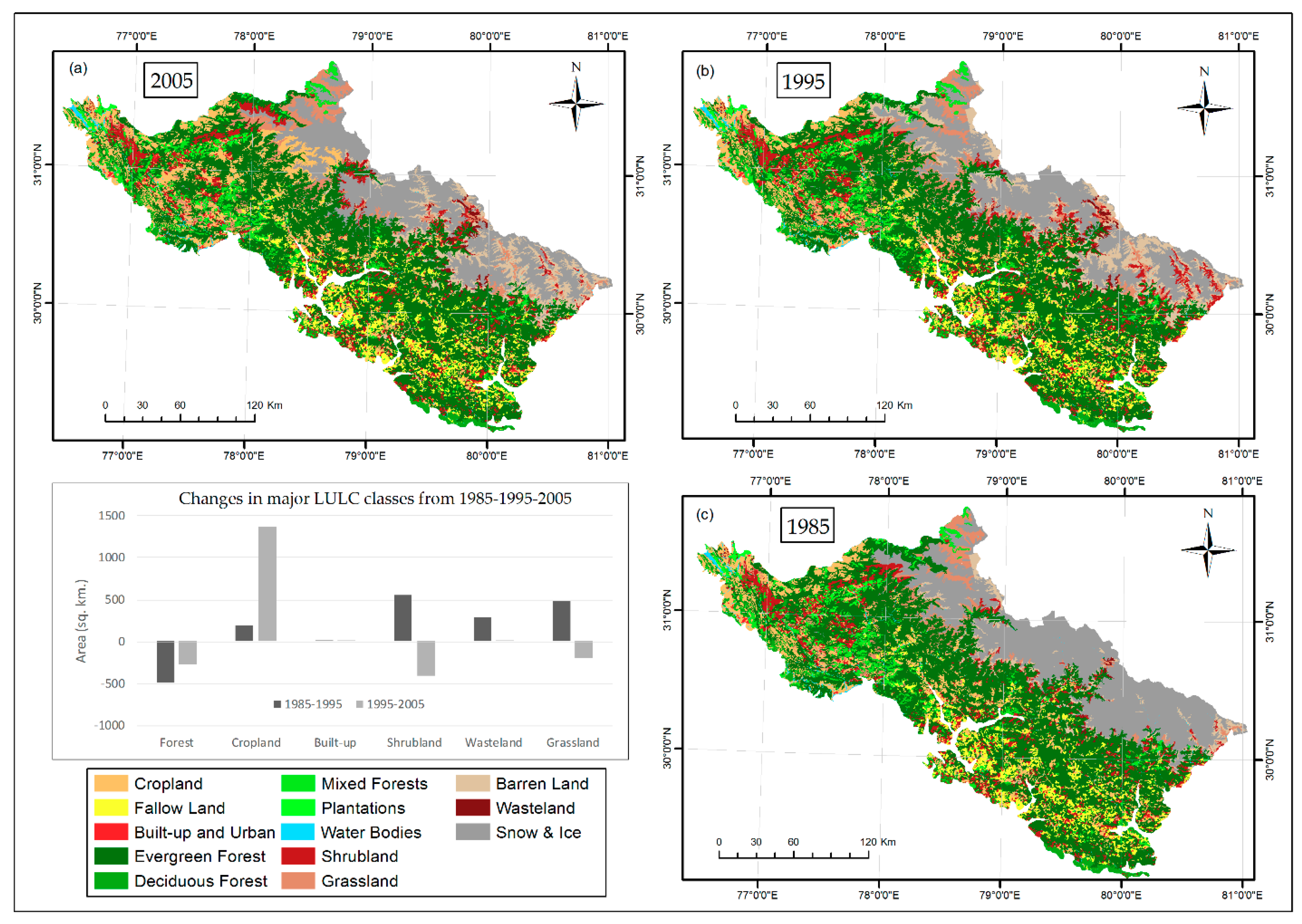
A few local/watershed-level studies [50,51] in this area revealed increases in agriculture and settlements at the expense of forest and barren land at elevations in the range of 1200 to 1600 m. Naqvi et al. [52] identified LUCC as the primary factor responsible for soil loss in this region and emphasized the importance of adopting soil conservation and vegetation rehabilitation measures to ameliorate soil loss. Munsi et al. [51] quantitatively analyzed the change in forest cover over a two-decade period (1990 to 2006) in the Shiwalik range of the Himalaya (lower Himalaya) in Uttarakhand and found that although forest areas are getting degraded by human disturbances, deforestation/degradation is not a key factor in the expansion of urban areas. Instead, agricultural and fallow lands were found to be the main contributors to the increase in urban areas. Increases in human activities enhance the deforestation rate, forest fragmentation, and the probability of forested areas being converted to another LULC class [53]. The dominant trend in land cover dynamics was found to be a decrease in scrub forest and alpine meadows along with an increase in open forest, cropland, and fallow land [54,55]. Natural Resources Census Project data [56,57] show a general decrease in agricultural land in the two western Himalayan states of Uttarakhand and Himachal Pradesh (2.5% and 6.5%, respectively) between 2005/2006 and 2011/2012; in contrast, the data indicate a significant increase in built-up land (78.1% and 7.8%, respectively) and barren land (55.4% and 50.8%, respectively) during this time period. Forest cover has decreased marginally by 5.61 km2 (0.04%) in Himachal Pradesh between 2005/2006 and 2011/2012, whereas forest cover has increased significantly by 425.17 km2 (1.7%) in the state of Uttarakhand. An analysis of the LULC data from [47] for the western Himalaya biotic zone (Figure 3) indicated a consistent decrease in forest area (1.94% from 1985 to 1995 and 1.07% from 1995 to 2005) along with significant increases in cropland (2.31% from 1985 to 1995 and 15.97% from 1995 to 2005) and built-up land (14.53% from 1985 to 1995 and 19.49% from 1995 to 2005).
4. Impact of Land Use and Land Cover Change on Ecosystem Services in the Western Himalayan Region
The Himalaya, which is often referred to as the Water Tower of Asia, provides key resources for livelihood, including food, fodder, timber, and medicine; a wide range of services such as fresh air, water, climate regulation, and carbon sequestration; and other services including recreational, cultural and spiritual well-being [58,59,60,61,62,63]. In terms of nature and types of ESS, western Himalayan biotic province shares similar characteristics as that of other parts of the Himalayan biogeographic zone. As many as 28 ESS have been identified to be flowing out of the central Himalayan forest ecosystems at three distinct elevation levels, including eight provisioning services (food, fodder, fiber, timber, fuel, fresh water, manure, non-timber forest products), nine regulatory services (air quality maintenance, micro-climate regulation, water regulation, water purification and waste treatment, soil erosion control/slope stability, regulation of soil fertility, biological regulation/pest control, carbon sequestration, seed dispersal), four cultural services (aesthetical value/traditional heritage, spiritual and religious, recreational and community activities, information and knowledge) and seven supporting services (soil formation, nutrient cycling, net primary productivity, pollination, biodiversity resources, wildlife habitat, grazing) [64]. While commercial exploitation such as large-scale infrastructure development and dam construction has historically been a primary cause of forest degradation in the entire Himalayan region including western Himalayan biotic province, chronic disturbances related to the harvesting of fuel wood and fodder, climate change, and changes in traditional land use practices have recently led to serious forest loss, degradation and significant effects on bird and other wildlife diversity [65]. Increased developmental activities, such as hydropower projects, are also modifying local ecosystems through the generation of debris and changes in water flow. The conversion of forested areas for agricultural expansion has resulted in increased surface runoff [66,67,68]. Natural springs are drying up completely, becoming seasonal, or experiencing reduced discharge [69,70,71,72,73], primarily due to land use changes that have led to decreased groundwater recharge. With the current rate of increase in mean annual temperature in various parts of the Himalayas triggered by climate change and local-level changes in land use (e.g., the conversion of forest area into built-up land), an upward movement of plants is expected [74,75,76,77,78,79,80]. Watershed-level carbon dynamics study carried out by Sharma and Rai [81] in the western Himalayan region found that intense LUCC is causing western Himalayan watersheds to become a net source of carbon in the atmosphere (7.78 MgC/ha/yr). Phenological studies indicate the widespread browning of irrigated croplands in contrast to the dominant greening of rain-fed cultivated areas. A spatiotemporal analysis of vegetation trends indicated an advancement of growing season in most regions [82,83,84]. With increasing temperature, upward shifts in agriculture may result in the loss of the remaining small patches of permanent pastures and arable grasslands (locally called Bugyals), loss of crop biodiversity, and reduction in productivity, which will in turn reduce the availability of fodder and adversely affect the livestock and agriculture sectors [85]. These trends in climate change and demographics brought about by rapid unplanned urbanization and related outmigration in the Himalayan region are likely to affect water and energy usage and food security in a variety of ways [86]; in particular, these trends may generate significant changes in land use by way of abandonment of traditional agroforestry practices [87,88] which will lead to land degradation as abandoned land does not automatically lead to re-generation of native vegetation [89]. Changes in traditional land use practices and market-based economies have led to serious vulnerabilities for traditional rain-fed subsistence agroforestry systems, which typically have high ecological adaptability and resilience. This in turn induces high soil loss, runoff, and input cost along with decreased farm productivity of introduced crop varieties with each passing years of cultivation [90,91,92,93,94]. Traditional agroforestry ecosystems, which are the source of many useful ESS [95], are being abandoned due to the outmigration of the male population, resulting in demographic changes and the conversion of agricultural land into permanent fallow [96]. Although many studies have discussed the state and dynamics of LULC change and their causes in western Himalayan region, little attention was given to address the impacts of such changes on various ecosystem services flowing out of this region. Table 2 summarizes list of few key studies that specifically dealt with the impact of land use land cover change on different ecosystem services in the region.
5. Existing Problems and Research Gaps in the Western Himalayan Region
Himalayan ecosystems provide crucial and valuable ESS in greater numbers than any other mountain system; downstream, more than one billion people depend on Himalayan ESS for their daily livelihood [97,98,99,100]. However, the local value of ESS is often ignored or inadequately understood [101]. An exploration of the upstream–downstream linkage reveals that upstream communities play a critical role in sustaining crucial ecosystem functions and the resulting supply of ESS to downstream communities [102]. This relationship may create equality problems. For example, why should products such as food security, hydroelectricity, and domestic water supply, which are consumed mainly by the downstream urban populations, be subsidized at the cost of upstream rural people where these ESS are generated? The lack of fair systems to share benefits with upstream communities where valuable ESS are generated [103], leads to vociferous local protests against development projects such as hydropower dams. Rural populations might choose to stop conserving ecosystems in favor of short-term local benefits, which would be dangerous in the long run if not disastrous. Thus, an appropriate mechanism needs to be developed to transfer the benefits from the consumers of ESS to the producers and in order to ensure fair transfer of benefits/payments for ecosystem services, it is necessary to thoroughly understand the flow of benefits through upstream–downstream linkages. As demonstrated in some parts of the western Himalayan region, it is important for local people to have access to subsidized energy alternatives and modern agricultural technology to enable them to conserve forest resources.
This review identifies some research gaps and critical questions. As LULC is often taken as a proxy for the provision of services [104], lack of spatial concordance between different LULC datasets as outlined in Section 3, will introduce uncertainty in the quantification of ESS across different time scales and may give a contradictory picture about the trend in change in ESS over time. Also the assumed linear relationship between ecosystem structure and provision of services is often untested for and is unlikely to be held as valid [105]. As a result, our understanding of the interaction between ecosystem processes and the resulting provision of services remains relatively poor for most ecosystems and services [106,107]. Certain problem areas exist. For example, in the high mountain areas it is difficult to collect socio-economic and ecological data due to biophysical and socio-political inaccessibility that hampers our understanding of socio-ecological processes and hinders qualitative and quantitative assessment of various services. Government policies mostly follow economic growth-based development models to fight poverty and handle environmental conservation issues. However, in remote and biodiverse areas native communities often have different needs, priorities, cultural requirements, and attachment to the ecosystems; welfare schemes by the government may not fulfill their aspirations as they are often left out of the decision-making process and do not have the capacity to negotiate. There is a need for participatory approaches that consider all stakeholders (i.e., farmers, scientists, agricultural extension agents, and policymakers) and engage and inform local people about the status of ecosystems and the value of their services. There is also a need to develop processes for each local community regarding conservation and maintenance of ESS by recognizing their cultural values and beliefs, traditional knowledge systems, and organizational capacity in decision-making processes and by adopting a participatory and coordinated mixed governance model, which will compliment state-imposed policies, to ensure sustainability of ESS [108,109].
6. Conclusions
Since 1960s, LUCC in western Himalaya, in line with the rest of India, was mainly characterized by agricultural expansion at the expense of forest land, fast population growth and urbanization. Despite being biodiversity rich and treasure trove of ESS, studies related to spatial mapping of ESS and impact of LULC change dynamics on ESS are sparse and not comprehensive in the western Himalayan region. A few watershed/micro-watershed/village level studies exist which identify the local ecosystem services and quantify them, but they do not map various ESS spatially or quantify their economic valuation, thus fail to portray the entire scenario of state and trend of ecosystem services potential of this important region. A regional/landscape level spatial map of area of production of crucial ecosystem services emanating from this region can be immensely beneficial to the national/regional level policy making so that conservation measure or alternative land use regimes can be planned in such a way that it will benefit both the native ecosystems and biodiversity as well as ensure local livelihood, towards achieving the sustainable development goals. Therefore, there is ample scope to carry out further research in this aspect through a large-scale interdisciplinary effort which will also explore the relationships between ecosystem services based on the role of land use change drivers and the interactions between the services.
Author Contributions
Y.Z. had conceptualized the idea for this review. P.P.M. had reviewed the materials and written the original draft. Y.Z. had scrutinized the manuscript and provided input in editing and finalizing the paper. All authors have read and approved the final manuscript.
Funding
This work is supported by a Strategic Priority Research Program of the Chinese Academy of Sciences (XDA20000000), National Natural Science Foundation of China (41761144081), International Partnership Program of Chinese Academy of Sciences (131C11KYSB20160061) and Chinese Academy of Sciences-The World Academy of Sciences (CAS-TWAS) President’s Fellowship Program for international Ph.D. students.
Acknowledgments
The authors are really grateful to Mr. Surajit Ghosh of International Center for Agricultural Research in the Dry Area (ICARDA), New Delhi, India for his valuable comments and inputs and the anonymous reviewers for their constructive suggestions to significantly enhance the manuscript.
Conflicts of Interest
The authors declare no conflict of interest.
References
- Peterson, G.D.; Carpenter, S.R.; Brock, W.A. Uncertainty and The Management of Multistate Ecosystems: An Apparently Rational Route to Collapse. Ecology 2003, 84, 1403–1411. [Google Scholar] [CrossRef]
- National Research Council. Advancing Land Change Modeling: Opportunities and Research Requirements; The National Academies Press: Washington, DC, USA, 2014; ISBN 978-0-309-28833-0. [Google Scholar]
- Rogan, J.; Chen, D. Remote sensing technology for mapping and monitoring land-cover and land-use change. Progr. Plan. 2004, 61, 301–325. [Google Scholar] [CrossRef]
- Pielke, R.A.; Pitman, A.; Niyogi, D.; Mahmood, R.; McAlpine, C.; Hossain, F.; Goldewijk, K.K.; Nair, U.; Betts, R.; Fall, S.; et al. Land use/land cover changes and climate: Modeling analysis and observational evidence. Wiley Interdiscip. Rev. Clim. Chang. 2011, 2, 828–850. [Google Scholar] [CrossRef]
- Climate Change 2013—The Physical Science Basis: Working Group I Contribution to the Fifth Assessment Report of the Intergovernmental Panel on Climate Change; Intergovernmental Panel on Climate Change (Ed.) Cambridge University Press: Cambridge, UK, 2014; ISBN 978-1-107-41532-4. [Google Scholar]
- Houghton, R.A.; House, J.I.; Pongratz, J.; van der Werf, G.R.; DeFries, R.S.; Hansen, M.C.; Le Quéré, C.; Ramankutty, N. Carbon emissions from land use and land-cover change. Biogeosciences 2012, 9, 5125–5142. [Google Scholar] [CrossRef] [Green Version]
- Phalan, B.; Onial, M.; Balmford, A.; Green, R.E. Reconciling Food Production and Biodiversity Conservation: Land Sharing and Land Sparing Compared. Science 2011, 333, 1289. [Google Scholar] [CrossRef]
- Briassoulis, H. Analysis of Land Use Change: Theoretical and Modeling Approaches; Regional Research Institute, West Virginia University Morgantown: Morgantown, WV, USA, 2000. [Google Scholar]
- Lambin, E.F.; Turner, B.L.; Geist, H.J.; Agbola, S.B.; Angelsen, A.; Bruce, J.W.; Coomes, O.T.; Dirzo, R.; Fischer, G.; Folke, C.; et al. The causes of land-use and land-cover change. Glob. Environ. Chang. 2001, 11, 261–269. [Google Scholar] [CrossRef]
- Lesschen, J.P.; Verburg, P.H.; Staal, S.J. Statistical Methods for Analyzing the Spatial Dimension of Changes in Land Use and Farming Systems; LUCC Focus 3 Office, Department of Environmental Sciences, Wageningen University, The Netherlands and The International Livestock Research Institute: Nairobi, Kenya, 2005; ISBN 92-9146-178-4. [Google Scholar]
- Meyer, W.B.; Turner, B.L. Human Population Growth and Global Land-Use/Cover Change. Annu. Rev. Ecol. Syst. 1992, 23, 39–61. [Google Scholar] [CrossRef]
- Turner Ii, B.L.; Skole, D.; Sanderson, S.; Fischer, G.; Fresco, L.; Leemans, R. Land-Use and Land-Cover Change. Science/Research Plan; IGBP Report: 35; IGBP: Stockholm, Sweden, 1995; ISBN 0284-8015. [Google Scholar]
- Ecosystems and Human Well-Being. Vol. 1: Current State and Trends; Hassan, R.M.; Millennium Ecosystem Assessment (Eds.) Millennium Ecosystem Assessment Series; Island Press: Washington, DC, USA, 2005; ISBN 978-1-55963-227-0. [Google Scholar]
- Singh, S.P. Balancing the approaches of environmental conservation by considering ecosystem services as well as biodiversity. Curr. Sci. 2002, 82, 1331–1335. [Google Scholar]
- Lawton, J.H. Nature’s Services. Societal Dependence on Natural Ecosystems; Daily, G.C., Ed.; Island Press: Washington, DC, USA, 1997; ISBN 1-55963-475-8. [Google Scholar]
- Boyd, J.W.; Banzhaf, H.S. What are Ecosystem Services? The Need for Standardized Environmental Accounting Units. SSRN Electron. J. 2006. [Google Scholar] [CrossRef] [Green Version]
- Kubiszewski, I.; Costanza, R.; Franco, C.; Lawn, P.; Talberth, J.; Jackson, T.; Aylmer, C. Beyond GDP: Measuring and achieving global genuine progress. Ecol. Econ. 2013, 93, 57–68. [Google Scholar] [CrossRef] [Green Version]
- Costanza, R.; de Groot, R.; Sutton, P.; van der Ploeg, S.; Anderson, S.J.; Kubiszewski, I.; Farber, S.; Turner, R.K. Changes in the global value of ecosystem services. Glob. Environ. Chang. 2014, 26, 152–158. [Google Scholar] [CrossRef]
- Fisher, J.A.; Patenaude, G.; Giri, K.; Lewis, K.; Meir, P.; Pinho, P.; Rounsevell, M.D.A.; Williams, M. Understanding the relationships between ecosystem services and poverty alleviation: A conceptual framework. Ecosyst. Serv. 2014, 7, 34–45. [Google Scholar] [CrossRef]
- Kubiszewski, I.; Anderson, S.J.; Costanza, R.; Sutton, P.C. The Future of Ecosystem Services in Asia and the Pacific: Future of EcoServices in Asia & Pacific. Asia Pac. Policy Stud. 2016, 3, 389–404. [Google Scholar] [CrossRef]
- Hunt, D.V.L.; Lombardi, D.R.; Atkinson, S.; Barber, A.R.G.; Barnes, M.; Boyko, C.T.; Brown, J.; Bryson, J.; Butler, D.; Caputo, S.; et al. Scenario Archetypes: Converging Rather than Diverging Themes. Sustainability 2012, 4, 740–772. [Google Scholar] [CrossRef] [Green Version]
- Raskin, P.; Banuri, T.; Gallopin, G.; Gutman, P.; Hammond, A.; Kates, R.W.; Swart, R. Great Transition: The Promise and Lure of the Times Ahead; Stockholm Environment Institute: Boston, MA, USA, 2002; ISBN 0-9712418-1-3. [Google Scholar]
- McGrail, S. Environmentalism in Transition? Emerging Perspectives, Issues and Futures Practices in Contemporary Environmentalism. J. Futures Stud. 2011, 15, 117–144. [Google Scholar]
- Transforming Our World: The 2030 Agenda for Sustainable Development. In A New Era in Global Health; Rosa, W. (Ed.) Springer Publishing Company: New York, NY, USA, 2017; ISBN 978-0-8261-9011-6. [Google Scholar]
- Willemen, L.; Drakou, E.G.; Dunbar, M.B.; Mayaux, P.; Egoh, B.N. Safeguarding ecosystem services and livelihoods: Understanding the impact of conservation strategies on benefit flows to society. Ecosyst. Serv. 2013, 4, 95–103. [Google Scholar] [CrossRef]
- Crossman, N.D.; Burkhard, B.; Nedkov, S.; Willemen, L.; Petz, K.; Palomo, I.; Drakou, E.G.; Martín-Lopez, B.; McPhearson, T.; Boyanova, K.; et al. A blueprint for mapping and modelling ecosystem services. Ecosyst. Serv. 2013, 4, 4–14. [Google Scholar] [CrossRef]
- Paavola, J.; Hubacek, K. Ecosystem Services, Governance, and Stakeholder Participation: An Introduction. Ecol. Soc. 2013, 18. [Google Scholar] [CrossRef]
- Schägner, J.P.; Maes, J.; Brander, L.M.; Hartje, V. Mapping Ecosystem Services’ Values: Current Practice and Future Prospects. SSRN Electron. J. 2012. [Google Scholar] [CrossRef] [Green Version]
- Bagstad, K.J.; Semmens, D.J.; Waage, S.; Winthrop, R. A comparative assessment of decision-support tools for ecosystem services quantification and valuation. Ecosyst. Serv. 2013, 5, 27–39. [Google Scholar] [CrossRef]
- Metzger, M.J.; Rounsevell, M.D.A.; Acosta-Michlik, L.; Leemans, R.; Schröter, D. The vulnerability of ecosystem services to land use change. Agric. Ecosyst. Environ. 2006, 114, 69–85. [Google Scholar] [CrossRef]
- Cabral, P.; Feger, C.; Levrel, H.; Chambolle, M.; Basque, D. Assessing the impact of land-cover changes on ecosystem services: A first step toward integrative planning in Bordeaux, France. Ecosyst. Serv. 2016, 22, 318–327. [Google Scholar] [CrossRef]
- Sharp, R.; Tallis, H.T.; Ricketts, T.; Guerry, A.D.; Wood, S.A.; Chaplin-Kramer, R.; Nelson, E.; Ennaanay, D.; Wolny, S.; Olwero, N.; et al. InVEST 3.5.0.post358+he23ea3e79185 User’s Guide. Available online: http://data.naturalcapitalproject.org/nightly-build/invest-users-guide/html/# (accessed on 9 June 2018).
- Rodgers, W.A.; Panwar, H.S.; Mathur, V.B. Wildlife Protected Areas in India: A Review (Executive Summary); Wildlife Institute of India: Dehradun, India, 2002; ISBN 81-85496-08-0. [Google Scholar]
- Ministry of Environment, Forest & Climate Change. State of Forest Report 2017. Available online: http://fsi.nic.in/forest-report-2017 (accessed on 18 November 2018).
- U.S. Geological Survey. Global 30 Arc-Second Elevation (GTOPO30). Available online: https://lta.cr.usgs.gov/GTOPO30 (accessed on 4 July 2018).
- Cartosat-1 Digital Elevation Model (CartoDEM). National Remote Sensing Centre, ISRO, Government of India: Hyderabad, India. Available online: http://bhuvan-noeda.nrsc.gov.in/data/download/index.php? (accessed on 4 July 2018).
- ESA CCI Land Cover Data. Available online: http://maps.elie.ucl.ac.be/CCI/viewer/download.php (accessed on 4 June 2018).
- Hansen, M.C.; Reed, B. A comparison of the IGBP DISCover and University of Maryland 1 km global land cover products. Int. J. Remote Sens. 2000, 21, 1365–1373. [Google Scholar] [CrossRef] [Green Version]
- Loveland, T.R.; Reed, B.C.; Brown, J.F.; Ohlen, D.O.; Zhu, Z.; Yang, L.; Merchant, J.W. Development of a global land cover characteristics database and IGBP DISCover from 1 km AVHRR data. Int. J. Remote Sens. 2000, 21, 1303–1330. [Google Scholar] [CrossRef] [Green Version]
- Klein Goldewijk, K.; Beusen, A.; Doelman, J.; Stehfest, E. Anthropogenic land use estimates for the Holocene—HYDE 3.2. Earth Syst. Sci. Data 2017, 9, 927–953. [Google Scholar] [CrossRef]
- Moulds, S.; Buytaert, W.; Mijic, A. A spatio-temporal land use and land cover reconstruction for India from 1960–2010. Sci. Data 2018, 5, 180159. [Google Scholar] [CrossRef]
- Roy, P.S.; Meiyappan, P.; Joshi, P.K.; Kale, M.P.; Srivastav, V.K.; Srivasatava, S.K.; Behera, M.D.; Roy, A.; Sharma, Y.; Ramachandran, R.M.; et al. Decadal Land Use and Land Cover Classifications across India 1985, 1995, 2005; ORNL Distributed Active Archive Center: Oak Ridge, TN, USA, 2016. [Google Scholar]
- Bicheron, P.; Defourny, P.; Brockmann, C.; Schouten, L.; Vancutsem, C.; Huc, M.; Bontemps, S.; Leroy, M.; Achard, F.; Herold, M.; et al. GLOBCOVER, Products, Description, and Validation Report. Available online: http://ionia1.esrin.esa.int/docs/GLOBCOVER_Products_Description_Validation_Report_I2.1.pdf (accessed on 12 July 2018).
- Bartholomé, E.; Belward, A.S. GLC2000: A new approach to global land cover mapping from Earth observation data. Int. J. Remote Sens. 2005, 26, 1959–1977. [Google Scholar] [CrossRef]
- Richards, J.F.; Flint, E.P. Historic land use and carbon estimates for South and Southeast Asia 1880–1980. In ORNL/CDIAC-61, NDP-046; Daniel, R.C., Ed.; Oak Ridge National Laboratory: Oak Ridge, TN, USA, 1994. [Google Scholar]
- Ministry of Statistics and Programme Implementation. Statistical Year Book India 2017. Available online: http://mospi.nic.in/ (accessed on 2 June 2018).
- Flint, E. Historical reconstruction of changes in land use and land cover of vegetation in the Gangetic Plain, 1880–1980: Methodology and case studies. In Land Use Historical Perspective—Focus on Indo-Gangetic Plains; Abrol, Y.P., Sangwan, S., Tiwari, M.K., Eds.; Allied Publishers Pvt. Limited: New Delhi, India, 2002; ISBN 81-7764-274-X. [Google Scholar]
- Abrol, Y.P.; Sangwan, S.; Tiwari, M.K. Land Use Historical Perspective—Focus on Indo-Gangetic Plains; Allied Publishers Pvt. Limited: New Delhi, India, 2002; ISBN 817764-274-X. [Google Scholar]
- Tian, H.; Banger, K.; Bo, T.; Dadhwal, V.K. History of land use in India during 1880–2010: Large-scale land transformations reconstructed from satellite data and historical archives. Glob. Planet. Chang. 2014, 121, 78–88. [Google Scholar] [CrossRef]
- Bisht, B.S.; Kothyari, B.P. Land-Cover change analysis of garur Ganga watershed using GIS/Remote Sensing technique. J. Indian Soc. Remote Sens. 2001, 29, 137–141. [Google Scholar] [CrossRef]
- Munsi, M.; Areendran, G.; Joshi, P.K. Modeling spatio-temporal change patterns of forest cover: A case study from the Himalayan foothills (India). Reg. Environ. Chang. 2012, 12, 619–632. [Google Scholar] [CrossRef]
- Naqvi, H.R.; Mallick, J.; Devi, L.M.; Siddiqui, M.A. Multi-temporal annual soil loss risk mapping employing Revised Universal Soil Loss Equation (RUSLE) model in Nun Nadi Watershed, Uttrakhand (India). Arab. J. Geosci. 2013, 6, 4045–4056. [Google Scholar] [CrossRef]
- Munsi, M.; Malaviya, S.; Oinam, G.; Joshi, P.K. A landscape approach for quantifying land-use and land-cover change (1976–2006) in middle Himalaya. Reg. Environ. Chang. 2010, 10, 145–155. [Google Scholar] [CrossRef]
- Sharma, M.; Areendran, G.; Raj, K.; Sharma, A.; Joshi, P.K. Multitemporal analysis of forest fragmentation in Hindu Kush Himalaya—A case study from Khangchendzonga Biosphere Reserve, Sikkim, India. Environ. Monit. Assess. 2016, 188. [Google Scholar] [CrossRef] [PubMed]
- Sharma, M.; Chakraborty, A.; Garg, J.K.; Joshi, P.K. Assessing forest fragmentation in north-western Himalaya: A case study from Ranikhet forest range, Uttarakhand, India. J. For. Res. 2017, 28, 319–327. [Google Scholar] [CrossRef]
- NRSC. Land Use/Land Cover Database on 1:50,000 Scale, Natural Resources Census Project, LUCMD, LRUMG, RS & GIS AA; National Remote Sensing Centre, ISRO: Hyderabad, India, 2006.
- NRSC. Land Use/Land Cover database on 1:50,000 scale, Natural Resources Census Project, LUCMD, LRUMG, RSAA; National Remote Sensing Centre, ISRO: Hyderabad, India, 2014.
- Grêt-Regamey, A.; Brunner, S.H.; Kienast, F. Mountain Ecosystem Services: Who Cares? Mt. Res. Dev. 2012, 32, S23–S34. [Google Scholar] [CrossRef]
- Schild, A. ICIMOD’s Position on Climate Change and Mountain Systems: The Case of the Hindu Kush–Himalayas. Mt. Res. Dev. 2008, 28, 328–331. [Google Scholar] [CrossRef]
- Bhat, J.A.; Iqbal, K.; Kumar, M.; Negi, A.K.; Todaria, N.P. Carbon stock of trees along an elevational gradient in temperate forests of Kedarnath Wildlife Sanctuary. For. Sci. Pract. 2013, 15, 137–143. [Google Scholar] [CrossRef]
- Sandhu, H.; Sandhu, S. Linking ecosystem services with the constituents of human well-being for poverty alleviation in eastern Himalayas. Ecol. Econ. 2014, 107, 65–75. [Google Scholar] [CrossRef]
- Ahmad, A.; Syed Moazzam, N. Carbon stocks of different land uses in the Kumrat Valley, Hindu Kush Region of Pakistan. J. For. Res. 2014, 26, 57–64. [Google Scholar] [CrossRef]
- Hamilton, L.S. When the Sacred Encounters Economic Development in Mountains. George Wright Forum 2015, 32, 132–140. [Google Scholar]
- Joshi, A.K.; Joshi, P.K. Forest Ecosystem Services in the Central Himalaya: Local Benefits and Global Relevance. Proc. Natl. Acad. Sci. India Sect. B Biol. Sci. 2018. [Google Scholar] [CrossRef]
- Thadani, R.; Singh, V.; Shahabuddin, G. Forests of the Western Himalaya. Curr. Sci. 2014, 107, 1225–1226. [Google Scholar]
- Sharma, E.; Bhuchar, S.; Xing, M.; Kothyari, B.P. Land use change and its impact on hydro-ecological linkages in Himalayan watersheds. Trop. Ecol. 2007, 48, 151–161. [Google Scholar]
- Tiwari, P.C. Land-use changes in Himalaya and their impact on the plains ecosystem: Need for sustainable land use. Land Use Policy 2000, 17, 101–111. [Google Scholar] [CrossRef]
- Tiwari, P. Land use changes in Himalaya and their impacts on environment, society and economy: A study of the Lake Region in Kumaon Himalaya, India. Adv. Atmos. Sci. 2008, 25, 1029–1042. [Google Scholar] [CrossRef]
- Tiwari, P.C.; Joshi, B. Environmental changes and their impact on rural water, food, livelihood, and health security in Kumaon Himalaya. Int. J. Urban Reg. Stud. Contemp. India 2014, 1, 1–12. [Google Scholar]
- Vashisht, A.K.; Sharma, H.C. Study on hydrological behaviour of a natural spring. Curr. Sci. 2007, 93, 4. [Google Scholar]
- Vashisht, A.K.; Bam, B. Formulating the spring discharge-function for the recession period by analyzing its recession curve: A case study of the Ranichauri spring (India). J. Earth Syst. Sci. 2013, 122, 1313–1323. [Google Scholar] [CrossRef]
- Tambe, S.; Kharel, G.; Arrawatia, M.; Kulkarni, H.; Mahamuni, K.; Ganeriwala, A.K. Reviving Dying Springs: Climate Change Adaptation Experiments from the Sikkim Himalaya. Mt. Res. Dev. 2012, 32, 62–72. [Google Scholar] [CrossRef]
- Valdiya, S.K.; Bartarya, S. Diminishing discharges of mountain springs in a part of Kumaun Himalaya. Curr. Sci. 1989, 58, 417–426. [Google Scholar]
- Grabherr, G.; Gottfried, M.; Pauli, H. Climate effects on mountain plants. Nature 1994, 369, 448. [Google Scholar] [CrossRef] [PubMed]
- Paulsen, J.; Weber, U.M.; Korner, C. Tree Growth near Treeline: Abrupt or Gradual Reduction with Altitude? Arct. Antarct. Alp. Res. 2000, 32, 14. [Google Scholar] [CrossRef]
- Pauli, H.; Gottfried, M.; Grabherr, G. High summits of the Alps in a changing climate. In “Fingerprints” of Climate Change; Walther, G.-R., Burga, C.A., Edwards, P.J., Eds.; Springer US: Boston, MA, USA, 2001; pp. 139–149. ISBN 978-1-4613-4667-8. [Google Scholar]
- Dubey, B.; Yadav, R.R.; Singh, J.; Chaturvedi, R. Upward shift of Himalayan pine in western Himalaya, India. Curr. Sci. 2003, 85, 2. [Google Scholar]
- Joshi, P.K.; Rawat, A.; Narula, S.; Sinha, V. Assessing impact of climate change on forest cover type shifts in Western Himalayan Eco-region. J. For. Res. 2012, 23, 75–80. [Google Scholar] [CrossRef]
- Brandt, J.S.; Haynes, M.A.; Kuemmerle, T.; Waller, D.M.; Radeloff, V.C. Regime shift on the roof of the world: Alpine meadows converting to shrublands in the southern Himalayas. Boil. Conserv. 2013, 158, 116–127. [Google Scholar] [CrossRef]
- Telwala, Y.; Brook, B.W.; Manish, K.; Pandit, M.K. Climate-Induced Elevational Range Shifts and Increase in Plant Species Richness in a Himalayan Biodiversity Epicentre. PLoS ONE 2013, 8, e57103. [Google Scholar] [CrossRef] [PubMed]
- Sharma, P.; Rai, S.C. Carbon sequestration with land-use cover change in a Himalayan watershed. Geoderma 2007, 139, 371–378. [Google Scholar] [CrossRef]
- Mishra, N.B.; Chaudhuri, G. Spatio-temporal analysis of trends in seasonal vegetation productivity across Uttarakhand, Indian Himalayas, 2000–2014. Appl. Geogr. 2015, 56, 29–41. [Google Scholar] [CrossRef]
- Ranjitkar, S.; Luedeling, E.; Shrestha, K.K.; Guan, K.; Xu, J. Flowering phenology of tree rhododendron along an elevation gradient in two sites in the Eastern Himalayas. Int. J. Biometeorol. 2013, 57, 225–240. [Google Scholar] [CrossRef]
- Hart, R.; Salick, J.; Ranjitkar, S.; Xu, J. Herbarium specimens show contrasting phenological responses to Himalayan climate. Proc. Natl. Acad. Sci. USA 2014, 111, 10615–10619. [Google Scholar] [CrossRef] [Green Version]
- Indian Network for Climate Change Assessment (INCCA). Climate Change and India: A 4x4 Assessment—A Sectoral and Regional Analysis for 2030s; Ministry of Environment and Forests: New Delhi, India, 2010.
- Mukherji, A.; Scott, C.; Molden, D.; Maharjan, A. Megatrends in Hindu Kush Himalaya: Climate Change, Urbanisation and Migration and Their Implications for Water, Energy and Food. In Assessing Global Water Megatrends; Biswas, A.K., Tortajada, C., Rohner, P., Eds.; Springer: Singapore, 2018; pp. 125–146. ISBN 978-981-10-6695-5. [Google Scholar]
- Pathak, S.; Pant, L.; Maharjan, A. De-Population Trends, Patterns and Effects in Uttarakhand, India—A Gateway to Kailash Mansarovar; ICIMOD Working Paper 2017/22; ICIMOD: Kathmandu, Nepal, 2017. [Google Scholar]
- Jaquet, S.; Schwilch, G.; Hartung-Hofmann, F.; Adhikari, A.; Sudmeier-Rieux, K.; Shrestha, G.; Liniger, H.P.; Kohler, T. Does outmigration lead to land degradation? Labour shortage and land management in a western Nepal watershed. Appl. Geogr. 2015, 62, 157–170. [Google Scholar] [CrossRef]
- Khanal, N.R.; Watanabe, T. Abandonment of Agricultural Land and Its Consequences. Mt. Res. Dev. 2006, 26, 32–40. [Google Scholar] [CrossRef]
- Nautiyal, S.; Kaechele, H.; Rao, K.S.; Maikhuri, R.K.; Saxena, K.G. Energy and economic analysis of traditional versus introduced crops cultivation in the mountains of the Indian Himalayas: A case study. Energy 2007, 32, 2321–2335. [Google Scholar] [CrossRef]
- Maikhuri, R.; Rao, K.; Semwal, R.L. Changing scenario of Himalayan agroecosystems: Loss of agrobiodiversity, an indicator of environmental change in Central Himalaya, India. Environmentalist 2001, 21, 23–39. [Google Scholar] [CrossRef]
- Sharma, G.; Hunsdorfer, B.; Singh, K.K. Comparative analysis on the socio-ecological and economic potentials of traditional agroforestry systems in the Sikkim Himalaya. Trop. Ecol. 2016, 57, 751–764. [Google Scholar]
- Arunachalam, A.; Khan, M.; Arunachalam, K. Balancing traditional jhum cultivation with modern agroforestry in eastern Himalaya—A biodiversity hot spot. Curr. Sci. 2002, 83, 117–118. [Google Scholar]
- Sharma, G.; Rai, L.K. Climate change and sustainability of agrodiversity in traditional farming of the Sikkim Himalaya. In Climate Change in Sikkim: Patterns Impacts, and Initiatives; Arrawatia, M., Tambe, S., Eds.; Information and Public Relations Department, Government of Sikkim: Gangtok, India, 2012; ISBN 978-81-920437-0-9. [Google Scholar]
- Padalia, K.; Bargali, S.S.; Bargali, K.; Parihaar, R.S. Socio-economic Analysis Based on Energy Input and Output of Mixed Cropping Systems of Bhabhar Region (Shiwalik Range of Kumaun Himalaya, India). Curr. Agric. Res. J. 2018, 6, 123–140. [Google Scholar] [CrossRef]
- Joshi, B. Recent Trends of Rural Out-migration and its Socio-economic and Environmental Impacts in Uttarakhand Himalaya. J. Urban Reg. Stud. Contemp. India 2018, 4, 1–14. [Google Scholar]
- OuYang, H. The Himalayas—water storage under threat. ICIMOD Sustain. Mt. Dev. 2009, 3–5. [Google Scholar]
- Xu, J.; Grumbine, R.E.; Shrestha, A.; Eriksson, M.; Yang, X.; Wang, Y.; Wilkes, A. The Melting Himalayas: Cascading Effects of Climate Change on Water, Biodiversity, and Livelihoods. Conserv. Boil. 2009, 23, 520–530. [Google Scholar] [CrossRef] [Green Version]
- Molden, D.J.; Vaidya, R.A.; Shrestha, A.B.; Rasul, G.; Shrestha, M.S. Water infrastructure for the Hindu Kush Himalayas. Int. J. Water Resour. Dev. 2014, 30, 60–77. [Google Scholar] [CrossRef]
- Sharma, B.; Rasul, G.; Chettri, N. The economic value of wetland ecosystem services: Evidence from the Koshi Tappu Wildlife Reserve, Nepal. Ecosyst. Serv. 2015, 12, 84–93. [Google Scholar] [CrossRef]
- van Oort, B.; Bhatta, L.D.; Baral, H.; Rai, R.K.; Dhakal, M.; Rucevska, I.; Adhikari, R. Assessing community values to support mapping of ecosystem services in the Koshi river basin, Nepal. Ecosyst. Serv. 2015, 13, 70–80. [Google Scholar] [CrossRef]
- Bhandari, P.; Kc, M.; Shrestha, S.; Aryal, A.; Shrestha, U.B. Assessments of ecosystem service indicators and stakeholder’s willingness to pay for selected ecosystem services in the Chure region of Nepal. Appl. Geogr. 2016, 69, 25–34. [Google Scholar] [CrossRef]
- Shrestha, P.; Lord, A.; Mukherji, A.; Shrestha, R.K.; Yadav, L.; Rai, N. Benefit Sharing and Sustainable Hydropower: Lessons from Nepal; ICIMOD: Kathmandu, Nepal, 2016. [Google Scholar]
- Nelson, E.; Mendoza, G.; Regetz, J.; Polasky, S.; Tallis, H.; Cameron, D.; Chan, K.M.; Daily, G.C.; Goldstein, J.; Kareiva, P.M.; et al. Modeling multiple ecosystem services, biodiversity conservation, commodity production, and tradeoffs at landscape scales. Front. Ecol. Environ. 2009, 7, 4–11. [Google Scholar] [CrossRef] [Green Version]
- Naidoo, R.; Balmford, A.; Costanza, R.; Fisher, B.; Green, R.E.; Lehner, B.; Malcolm, T.R.; Ricketts, T.H. Global mapping of ecosystem services and conservation priorities. Proc. Natl. Acad. Sci. USA 2008, 105, 9495–9500. [Google Scholar] [CrossRef] [PubMed] [Green Version]
- Bennett, E.M.; Peterson, G.D.; Gordon, L.J. Understanding relationships among multiple ecosystem services: Relationships among multiple ecosystem services. Ecol. Lett. 2009, 12, 1394–1404. [Google Scholar] [CrossRef]
- Carpenter, S.R.; Mooney, H.A.; Agard, J.; Capistrano, D.; DeFries, R.S.; Diaz, S.; Dietz, T.; Duraiappah, A.K.; Oteng-Yeboah, A.; Pereira, H.M.; et al. Science for managing ecosystem services: Beyond the Millennium Ecosystem Assessment. Proc. Natl. Acad. Sci. USA 2009, 106, 1305–1312. [Google Scholar] [CrossRef] [Green Version]
- Kandel, P.; Tshering, D.; Uddin, K.; Lhamtshok, T.; Aryal, K.; Karki, S.; Sharma, B.; Chettri, N. Understanding social-ecological interdependence using ecosystem services perspective in Bhutan, Eastern Himalayas. Ecosphere 2018, 9, e02121. [Google Scholar] [CrossRef]
- Badola, R.; Hussain, S.A.; Dobriyal, P.; Barthwal, S. Assessing the effectiveness of policies in sustaining and promoting ecosystem services in the Indian Himalayas. Int. J. Biodivers. Sci. Ecosyst. Serv. Manag. 2015, 11, 216–224. [Google Scholar] [CrossRef]
Figure 1.
Location of Western Himalaya Biotic Province [33] with Elevation data (freely available GTOPO data from the U.S. Geological Survey [35] and CartoDEM from NRSC/ISRO [36]).

Figure 2.
Comparative analysis of major LULC classes for the western Himalayan biotic province as estimated by various studies for the year 2005.
Figure 2.
Comparative analysis of major LULC classes for the western Himalayan biotic province as estimated by various studies for the year 2005.

Figure 3.
Land-use and Land-cover pattern of Western Himalaya Biotic Province; Data Source: [48].
Figure 3.
Land-use and Land-cover pattern of Western Himalaya Biotic Province; Data Source: [48].

Table 1.
Summarization of studies on Land-use Land-cover (LULC) (in sq. km.) by various sources in western Himalayan biotic province.
Table 1.
Summarization of studies on Land-use Land-cover (LULC) (in sq. km.) by various sources in western Himalayan biotic province.
| Year | Dataset | Forest | Cropland | Built-Up | Dataset Type | Reference |
|---|---|---|---|---|---|---|
| 2015 | ESA CCI | 31644.00 | 9890.19 | 34.83 | S | [37] |
| MODIS-UMD | 12584.00 | 4541.50 | 38.50 | S | [38] | |
| MODIS-IGBP | 12584.00 | 4541.50 | 38.50 | S | [39] | |
| HYDE 3.2 | - | 8682.91 | 55.55 | C | [40] | |
| 2010 | ESA CCI | 31707.63 | 9897.03 | 25.38 | S | [37] |
| MODIS-UMD | 11631.25 | 5572.00 | 37.25 | S | [38] | |
| MODIS-IGBP | 11631.25 | 5572.00 | 37.25 | S | [39] | |
| Moulds | 24651.17 | 9684.60 | 124.22 | C | [41] | |
| HYDE 3.2 | - | 8707.14 | 50.13 | C | [40] | |
| 2005 | Roy et al. | 24617.24 | 9748.88 | 118.68 | S | [42] |
| ESA CCI | 31535.91 | 10041.03 | 16.92 | S | [37] | |
| MODIS-UMD | 11908.75 | 6073.50 | 37.25 | S | [38] | |
| MODIS-IGBP | 11909.00 | 6073.50 | 37.25 | S | [39] | |
| GlobCover | 18605.97 | 15601.32 | - | S | [43] | |
| Moulds | 24610.50 | 9749.06 | 119.37 | C | [41] | |
| HYDE 3.2 | - | 8674.66 | 47.35 | C | [40] | |
| 2000 | ESA CCI | 31185.54 | 10341.18 | 3.96 | S | [37] |
| GLC2000 | 28128 | 18114 | - | S | [44] | |
| Moulds | 24839.92 | 9651.86 | 110.25 | C | [41] | |
| HYDE 3.2 | - | 8542.80 | 41.54 | C | [40] | |
| 1995 | Roy et al. | 24884.29 | 8544.50 | 99.32 | S | [42] |
| ESA CCI | 31041.72 | 10513.98 | 2.61 | S | [37] | |
| Moulds | 25123.01 | 9622.09 | 107.59 | C | [41] | |
| 1985 | Roy et al. | 25375.40 | 8351.61 | 86.72 | S | [42] |
| Moulds | 25558.40 | 9418.54 | 99.19 | C | [41] | |
| 1980 | Moulds | 25752.74 | 9322.32 | 95.56 | C | [41] |
| HYDE 3.2 | - | 8160.14 | 24.77 | C | [40] | |
| 1970 | Moulds | 28078.07 | 7192.98 | 81.84 | C | [41] |
| HYDE 3.2 | - | 7897.66 | 20.82 | C | [40] | |
| 1960 | Moulds | 28674.40 | 6568.36 | 71.70 | C | [41] |
| HYDE 3.2 | - | 7581.77 | 18.33 | C | [40] | |
| 1880 | HYDE 3.2 | - | 4657.19 | 12.34 | C | [40] |
S = Spatial, C = Spatial + Non-spatial (inventory).
Table 2.
List of key studies on the impact of land-use and land-cover change (LUCC) on ecosystem services (ESS).
Table 2.
List of key studies on the impact of land-use and land-cover change (LUCC) on ecosystem services (ESS).
| Spatial/Non-Spatial | Study Scale | ESS Quantified? | ESS | Reference | |||
|---|---|---|---|---|---|---|---|
| Provisioning Services | Regulatory Services | Supporting Services | Cultural Services | ||||
| Spatial | local/micro-watershed | yes | water regulation (surface runoff), soil erosion control (sediment output) | [67] | |||
| Spatial | local/micro-watershed | yes | food, fodder, fuel, fresh water | flood regulation/protection | [68] | ||
| Spatial | local/watershed | yes | food, fresh water, manure, fodder, fuel | water regulation (irrigation) | [69] | ||
| Spatial | local/watershed | yes | carbon sequestration | [81] | |||
| Non- spatial | local/village level | no | food, fodder | biological regulation/weed control, soil erosion control, water regulation | net primary productivity | [91] | |
| Spatial | state level | no | net primary productivity | [82] | |||
© 2018 by the authors. Licensee MDPI, Basel, Switzerland. This article is an open access article distributed under the terms and conditions of the Creative Commons Attribution (CC BY) license (http://creativecommons.org/licenses/by/4.0/).
Share and Cite
MDPI and ACS Style
Mondal, P.P.; Zhang, Y. Research Progress on Changes in Land Use and Land Cover in the Western Himalayas (India) and Effects on Ecosystem Services. Sustainability 2018, 10, 4504. https://doi.org/10.3390/su10124504
AMA Style
Mondal PP, Zhang Y. Research Progress on Changes in Land Use and Land Cover in the Western Himalayas (India) and Effects on Ecosystem Services. Sustainability. 2018; 10(12):4504. https://doi.org/10.3390/su10124504
Chicago/Turabian StyleMondal, Partho Protim, and Yili Zhang. 2018. "Research Progress on Changes in Land Use and Land Cover in the Western Himalayas (India) and Effects on Ecosystem Services" Sustainability 10, no. 12: 4504. https://doi.org/10.3390/su10124504
Note that from the first issue of 2016, this journal uses article numbers instead of page numbers. See further details here.