Article

Variation in Mountain Vegetation Composition between the East and the West Sides of Southern Taiwan

1
Graduate Institute of Bioresources, National Pingtung University of Science and Technology, Pingtung 91201, Taiwan
2
Department of Forestry, National Pingtung University of Science and Technology, Pingtung 91201, Taiwan
*
Author to whom correspondence should be addressed.
Forests 2016, 7(8), 179; https://doi.org/10.3390/f7080179
Submission received: 21 April 2016 / Revised: 25 July 2016 / Accepted: 15 August 2016 / Published: 18 August 2016

Abstract

:
In this study, we classified twenty associations, 179 families, 810 genera, 1897 species, and identified 291 rare species. The vegetation units were named following floristic-sociological approach. A cocktail determination key was used to classify the following vegetation units of association. More of the west side than the east side of the study area was at a higher altitude, and the vegetation experienced significant compression. Follow the result of detrended correspondence analysis (DCA), winter rainfall and average January temperature were the main environmental factors affecting variation in vegetation distribution by elevation gradient in this area. The particular association type on the eastern side of the study area is attributable to the northeast monsoon experienced year-round in this area, which causes relatively low temperature and humidity and wind rush, as well as the compression of the elevation range in each forest. The monsoon deciduous vegetation area exists only on the west of the low altitude mountains.

1. Introduction

Situated on the Tropic of Cancer, Taiwan is a subtropical island that is rich in natural forests. Its mountainous topography (highest peak: 3952 m a.s.l.) forms distinct altitudinal vegetation zones, with vegetation corresponding to several latitudinal zones from subarctic to tropical [1] and different geographic areas that vary by precipitation and temperature. Based on climatic data, Taiwan has been classified into seven ecoregions [2]. Our study area involved the west and east sides of Southern Taiwan. Although the west and east sides are close, the types and distribution of vegetation in these areas differ according to the climate [2]. The weather on the west side is moist in summer and dry in winter. By contrast, the weather on the east side is moist the entire year. Several studies have evaluated the types and distribution of vegetation in these areas [3,4,5,6,7,8,9,10,11]. However, synthetic comparative studies that investigate vegetation types across Southern Taiwan on the basis of floristic composition are lacking, except for studies on Chamaecyparis montane cloud forests [12], high-mountain coniferous forests [13], and beech forests [14] in other areas. Formalized vegetation classification can comprise repeatable classification sometimes accompanied by unequivocally described rules for assigning individual vegetation stands to classification units [15]. To classify vegetation types formally, unsupervised numerical classification methods such as cluster analysis [16] or TWINSPAN [17], which consistently apply selected classification criteria to the whole data set, can be used. To describe and parameterize recognized vegetation types, formalization can be achieved using supervised classification methods that create unequivocal rules and criteria for determining vegetation types. An example is the cocktail determination key [18,19,20,21], which describes each vegetation type using a logical formula that combines statements concerning the presence or absence of typical or dominant species [1]. The cocktail determination key was developed by combining the presence or absence of specific ecologically meaningful species groups [18] that provide unequivocal rules for assigning relevés to vegetation types [20,21,22,23]. We used the vegetation dataset from the National Vegetation Database of Taiwan and used the cocktail determination key to defining unequivocal assignment rules for each vegetation type in this study. We established vegetation types (associations) and sampled environment factors in the study area. In the present study, we describe the most crucial determinants of floristic composition and ecologically essential vegetation types by sampled relevés and environment factors. Furthermore, understanding relationships between vegetation types and environmental factors in Southern Taiwan can facilitate understanding diversity patterns across all of the Taiwan and vegetation change.

2. Materials and Methods
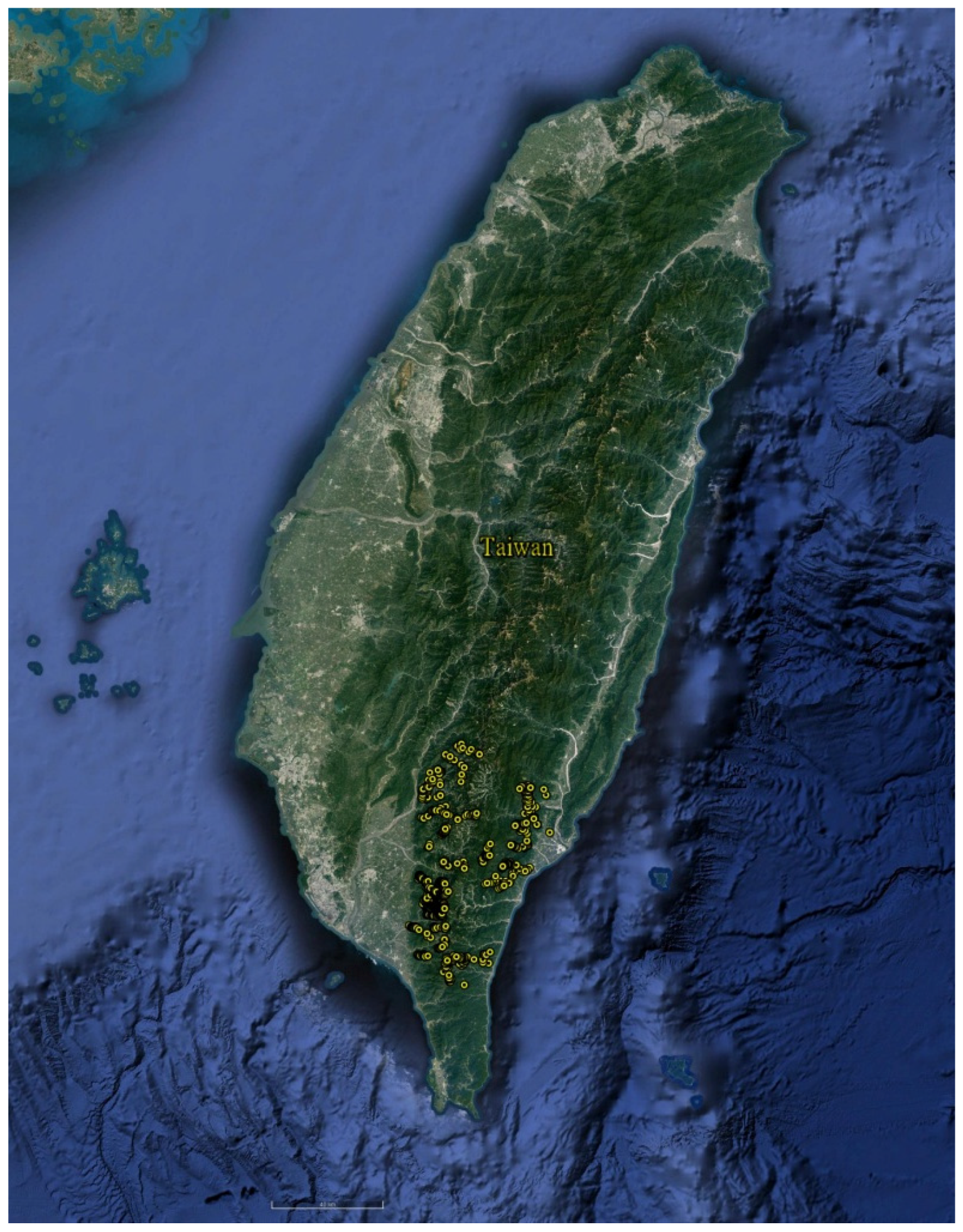
2.1. Study Area

Southern Taiwan is a mountainous area located on the Tropic of Cancer. Its area is more than 12,000 km2, and the Central Ridge contains more than 50 peaks that are 3000 m asl. Metamorphic rocks are the main bedrock, except in the lowland sedimentary plains. Steep and fragile slopes are common, and landslides frequently occur following heavy rains, road construction, or earthquakes. Temperature mostly corresponds with altitude, with a mean altitudinal lapse rate of 0.55 °C per 100 m, whereas differences in precipitation are caused primarily by monsoon exposure, particularly the northeastern monsoon in winter [1]. In summer, the warm southwestern monsoons and typhoons lead to abundant precipitation across the entire island. In winter, the cool northeastern monsoon leads to moderate precipitation on only the windward slopes. The area not influenced by the winter monsoon experiences a dry period of 2 to 6 months [12]. Because of the northeastern monsoon in winter, southwestern Taiwan experiences a dry season of 6 months from late October to early April; however, southeastern Taiwan does not experience a dry season. More than two typhoons typically hit Taiwan each year in the period from June to September [24]. According to a 2005 inventory made by the Taiwan Forestry Bureau, forests cover 58% of Taiwan. Natural forests, including successional forests after natural disturbances, are concentrated on poorly accessible steep slopes, in remote mountain areas, and in areas without drinking water, soil resources, or seeds from timber species. Of the remaining natural forests, 53% are broadleaf forests, and the remaining are mixed or coniferous forests. Several original broadleaf evergreen forests below 500 m a.s.l. have been converted into buildings or agricultural lands, including bamboo plantations [25]. Su [26] evaluated overall vegetation patterns and proposed six altitudinal vegetation zones by some dominant species in Taiwan that include Abies, Tsuga, Quercus (upper), Quercus (lower), MachilusCastanopsis, and FicusMachilus zones, but drier habitats were more suitable for deciduous or coniferous trees than for broad-leaved evergreens. This scheme was commonly accepted by Taiwanese foresters and vegetation ecologists and widely applied in nature resource management.

2.2. Vegetation Data and Environmental Variables

There were 891 relevés in the study area (Figure 1) that were used classification. The vegetation relevés were taken from the National Vegetation Database of Taiwan (AS-TW-001) and from a field survey. The National Vegetation Database of Taiwan (AS-TW-001) comprises data from 2003 to the end of 2011. It includes 3564 relevés that were sampled in 2003 to 2007 as a part of a vegetation mapping project organized by the Taiwan Forestry Bureau [27]. Other relevés were taken from a field survey conducted in 2010 to 2014. The standardized relevé size was 20 × 20 m2, the floristic data included trees and shrubs taller than 1.5 m. The diameter at breast height (DBH) of all individuals in this layer was measured and DBH data were used to calculate the importance value index (IVI: relative dominance, represented by the basal area + relative density, represented by the number of individuals). All the vascular plant species including trees, shrubs, herbs, lianas, and epiphytes were recorded in these relevés. The percentage cover of lianas, epiphytes, and herbs was estimated and used as a measure of abundance and richness. Information about life forms of all the species, endemic rate, invasive rate and leaf types (coniferous, deciduous broad-leaved or evergreen broad-leaved) of tree species were compiled from the Flora of Taiwan [28].
In total, the following eight environmental variables were evaluated: altitude, canopy cover, slope inclination, rock cover, rockiness, ratio of winter precipitation (WP), temperature in January (T1), and topography. Environmental factors such as altitude, slope inclination, aspect, and geographic coordinates of relevés were measured in the field, and rock cover and rockiness were estimated in each relevés. Topography was recorded on a 1 to 6 ordinal scale (1 (ridge), 2 (upper slope), 3 (middle slope), 4 (lower slope), 5 (valley), and 6 (plain)) and was used as a surrogate for soil water availability. Rock cover was estimated as the percentage of area covered by stones larger than 10 cm inside the relevés, and rockiness was estimated as the percentage content of stones with sizes 1~10 cm in the soil. Canopy cover and height were estimated in the field, and the canopy cover was used as a surrogate for light conditions in the understory. Temperature in January was calculated from the monthly mean temperatures computed from satellite images with a resolution of 1 km × 1 km. Temperature data derived from satellite images were more sensitive to topography than the temperature data calculated from the regression model of weather stations [1]. Winter precipitation (the ratio of the sum of precipitation of December, January and February divided by the annual precipitation) was taken as interpolated values from the WorldClim database [29].

2.3. Classification of Vegetation Types

In this study, association was a community unit with homogeneous floristic composition and similar habitat conditions among relevés [30] that was the basic vegetation unit in the Braun–Blanquet system and named by the floristic-sociological approach [31]. In this study, we define association as a community unit with homogeneous floristic composition and similar habitat requirements among plots and classified associations by the cocktail determination key, which provided information on the environment and species composition, which evaluates the composition of different habitats and species. The cocktail determination key is a crucial basis for establishing different species groups. The species group comprises different species that have a similar geographical area and habitat [23,32]. The species groups were based on the species established, and selected from the National Vegetation Database of Taiwan (AS-TW-001) by fidelity (phi coefficient). There were three crucial elements in the cocktail determination key: species groups, logical operators (AND, OR, WITH, WITHOUT, and NOT), and numbers as defining criteria for specifying how many species from a species group must occur in a relevés for the group to be considered present in the relevés. For the species groups, the cover of each species was added to more clearly define them; alternatively, only their presence or absence was considered. Twenty associations were established using cocktail determination key in this study. The cocktail determination key can accurately divide species into different vegetation types; however, when the database search for that vegetation type fails to retrieve a complete identity for that unit of vegetation from the retrieval table, a sample area may be unclassifiable; in such cases researchers should determine new methods for retrieving vegetation type definitions to facilitate gradually establishing a complete database of vegetation units. If the sample could not be defined as a new vegetation unit, then the sample the similarity of species composition with other associations was calculated to determine the most approach association. Therefore, classifying a vegetation unit through the vegetation type may indicate a richness of environmental information. However, retrieving species group changes can be impossible when searching for the association if the sample of the repository has increased or is inconsistent with the status of the classification results. Nonetheless, we followed the discussed steps to determine changes in species groups. We divided the study area into east and west sides by relevés and different zones (Abies, Tsuga, Quercus (upper), Quercus (lower), MachilusCastanopsis, and FicusMachilus zones) by some dominant species, the distribution of altitudes was evaluated in this study follow even warn of its effects on vegetation.

2.4. Ordination, Synoptic Table and Software

Ordination by detrended correspondence analysis (DCA) was used to visualize major gradients. A square-root transformation was applied to IVI data of trees and shrubs prior to the analysis. The synoptic table was summarized by species composition of the resulting vegetation types, in which diagnostic species were identified using a fidelity calculation. Fidelity was measured us as the Phi coefficient of association (Φ). Environmental factors were associated with the first two DCA axes using multiple regression [33]. Species data and a synoptic table were prepared using JUICE Version 7.0.84 software [34]. The ordination diagram and related analysis were computed using the R Version 3.0.1 statistical package [35] and the vegan library package [36].

3. Results

3.1. Vascular Plants and Rare Plant Species

Our data include 179 families, 810 genera, and 1897 species (Supplementary Table S1). The endemic rate and invasive rate in the study area were 24.4%. The staseff included 375 pteridophytes, 23 gymnosperms, 1141 dicotyledons, and 358 monocotyledons. The dicotyledons comprised 70 Fabaceae, 63 Asteraceae, 46 Euphorbiaceae, 46 Lauraceae, 45 Rubiaceae, and 39 Rosaceae species. The monocotyledons comprised 78 Poaceae, 130 Orchidaceae, 32 Cyperaceae, 19 Smilacaceae, and 20 Liliaceae species. A rare species assessment based on the preliminary red list of Taiwanese vascular plants [7] identified 291 rare species, including 10 critically endangered, 32 endangered, 91 vulnerable, 119 near-threatened, and 39 data-deficient species (Supplementary Table S1).

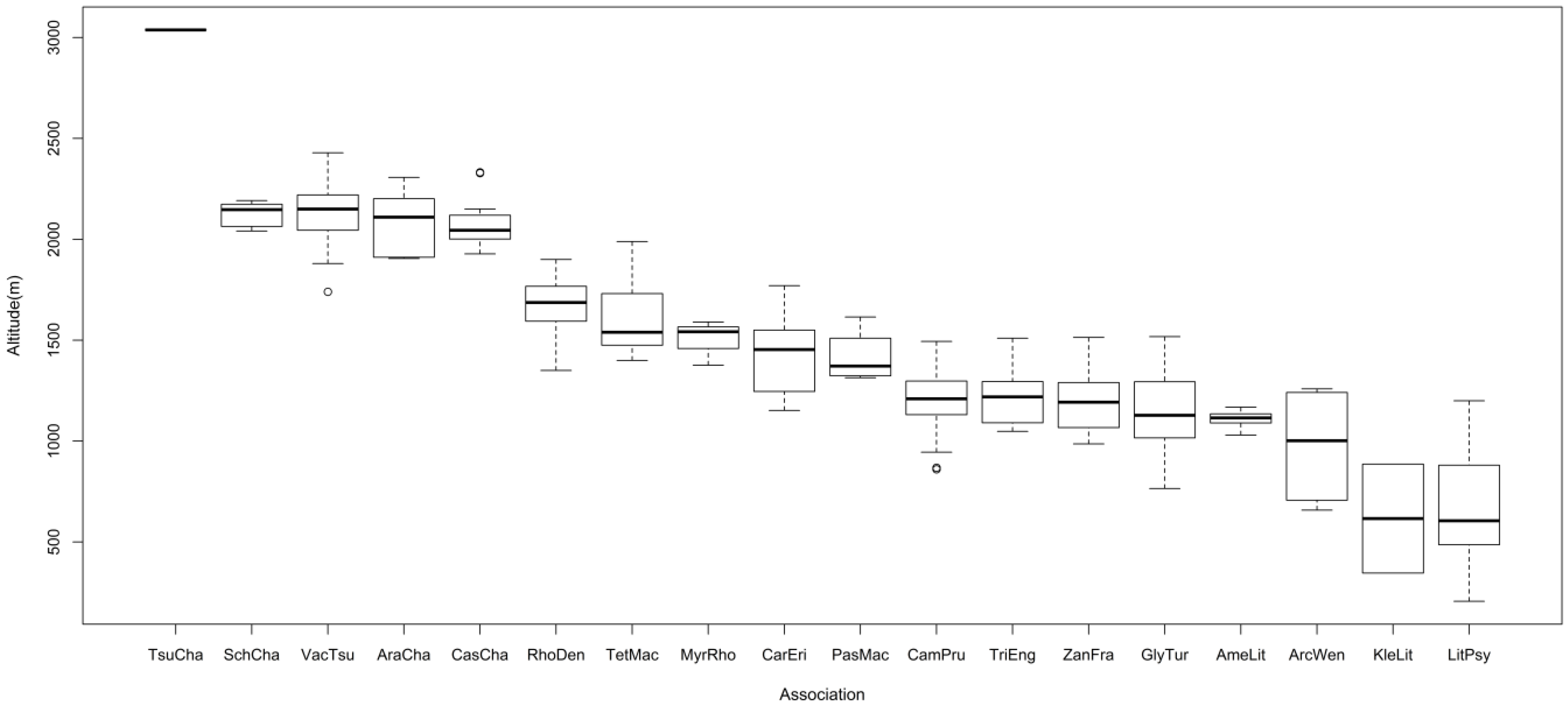
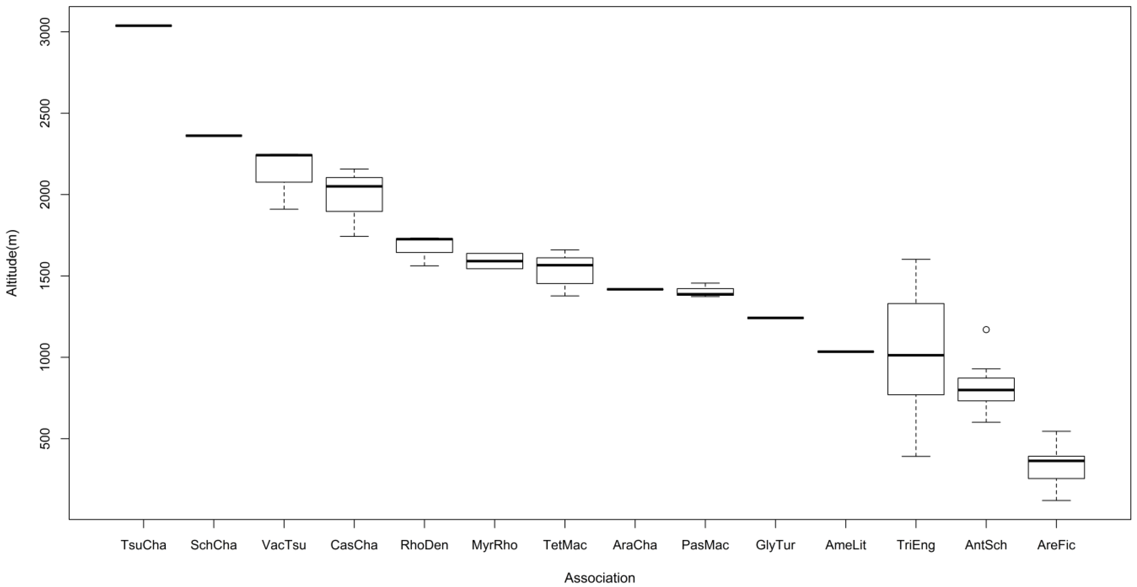
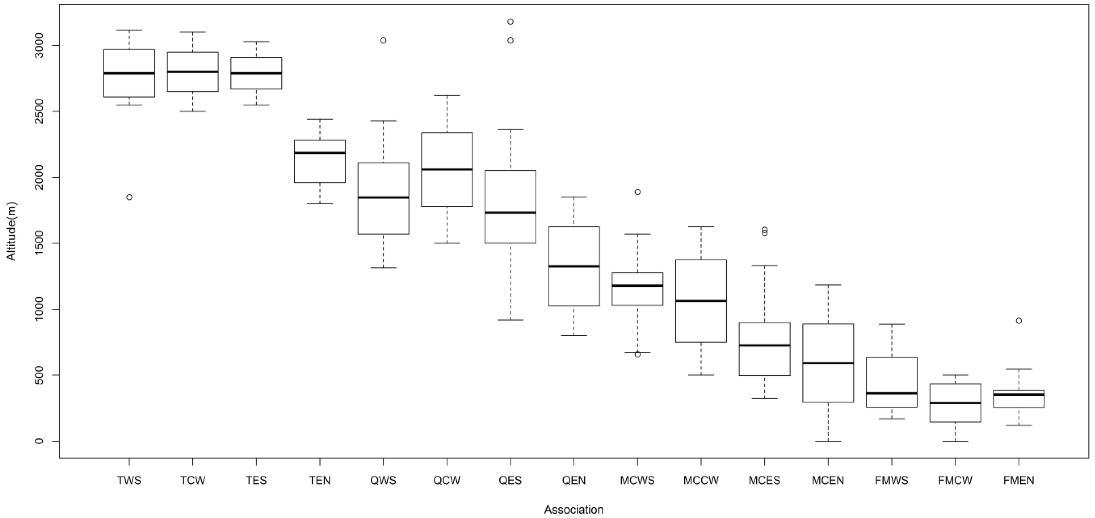
3.2. Vegetation Types

A cocktail determination key was used to classify the following associations (Supplementary Table S2): Tsugo formosanaeChamaecyparidetum formosanae Ching-Yu Liou ex Ching-Feng Li et al. 2014 ass. nova hoc loco; Tetrastigmo umbellateMachilietum japonicae Yi-Shin Chian et al. 2016 ass. Nov.hoc loco; Vaccinio lasiostemonisTsugetum formosanae Ching-Feng Li et al. 2014 ass. nov. hoc loco; Schefflero taiwanianaeChamaecyparidetum formosensis Ching-Long Yeh et Chien-Chun Liao ex Ching-Feng Li et al. 2014 ass. nov. hoc loco; Castanopsio carlesiiChamaecyparidetum formosensis Ching-Feng Li et al. 2014 ass. nov. hoc loco; Arachniodo rhomboideaeChamaecyparidetum formosensis Ching-Feng Li et al. 2014 ass. nov. hoc loco; Rhododendro formosanaeDendropanacetum dentigeri Yi-Shin Chian et al. 2016 ass. Nov.hoc loco; Antidesmo hiiranenseSchimetum kankaoensis Yi-Shin Chian et al. 2016 ass. Nov.hoc loco; Archidendro lucidaeWendlandietum uvariifoliae Yi-Shin Chian et al. 2016 ass. Nov.hoc loco; Camellio salicifoliaePrunetum phaeostictae Yi-Shin Chian et al. 2016 ass. Nov.hoc loco; Glycosmio citrifoliaeTurpinietum formosanae Yi-Shin Chian et al. 2016 ass. Nov.hoc loco; Tricalysio dubiaeEngelhardietum roxburghianae Yi-Shin Chian et al. 2016 ass. Nov.hoc loco; Amentotaxo formosanaeLitsetum acutivenae Yi-Shin Chian et al. 2016 ass. Nov.hoc loco; Pasanio konishiiMachiletum thunbergii Yi-Shin Chian et al. 2016 ass. Nov.hoc loco; Myrico adenophoraeRhododendretum formosanum Yi-Shin Chian et al. 2016 ass. Nov.hoc loco; Arengo tremulaeFicetum irisanae Yi-Shin Chian et al. 2016 ass. Nov.hoc loco; Carpino kawakamiiEriobotryetum deflexa Yi-Shin Chian et al. 2016 ass. Nov.hoc loco; Zanthoxylo pistaciiflorumFraxinuetum insularis Yi-Shin Chian et al. 2016 ass. Nov.hoc loco; Litseo akoensisPsychotrietum rubrae Yi-Shin Chian et al. 2016 ass. Nov.hoc loco; and Kleinhovio hospitaeLitseetum hypophaeae Yi-Shin Chian et al. 2016 ass. Nov.hoc loco. The distributions of associations in the study area were from 120 to 3000 m and comprised the Tsuga, Quercus, MachilusCastanopsis, and FicusMachilus zones [37]. There are 18 associations in southwestern side (Figure 2) and 14 associations in southeastern side (Figure 3).

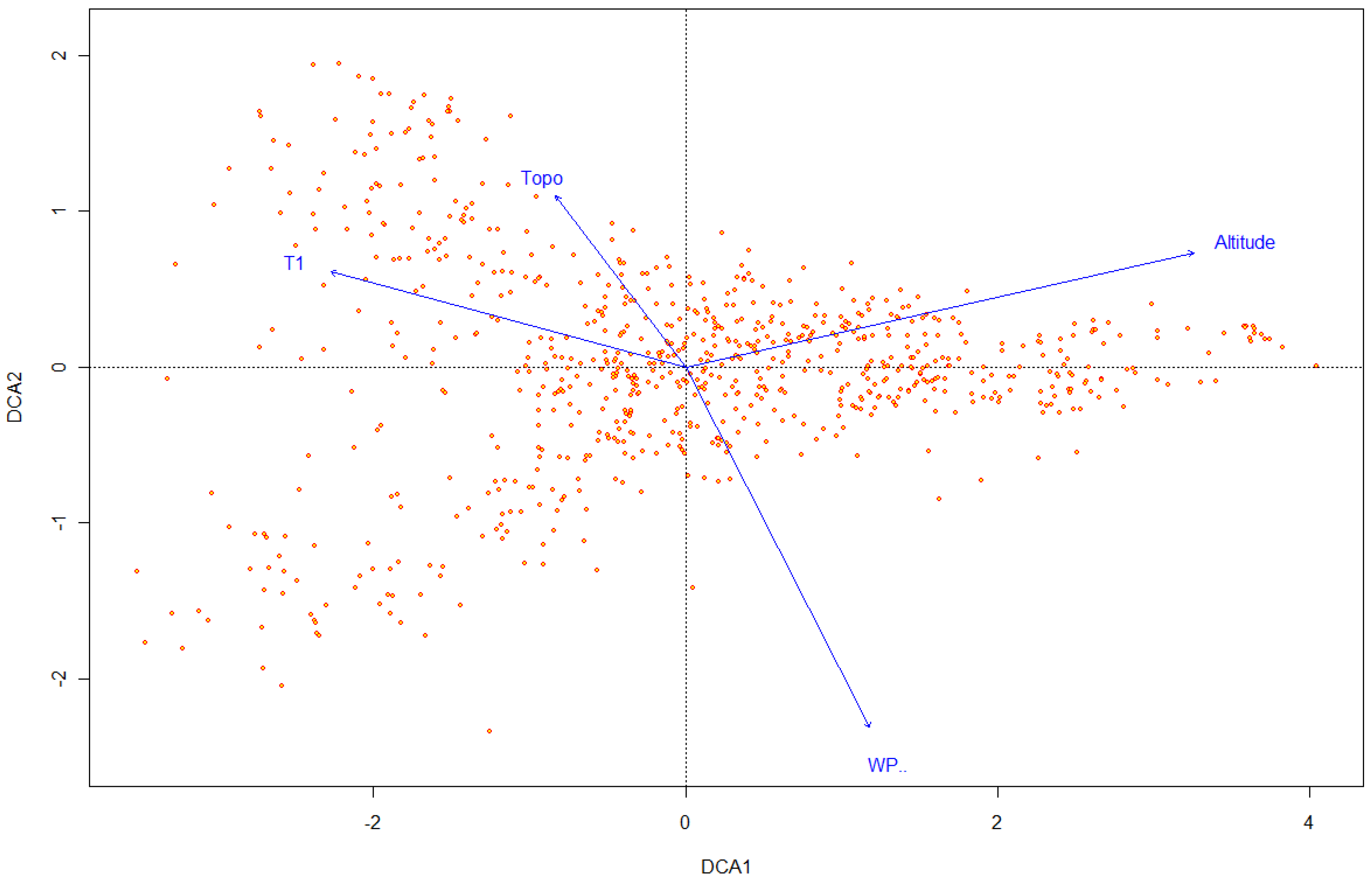
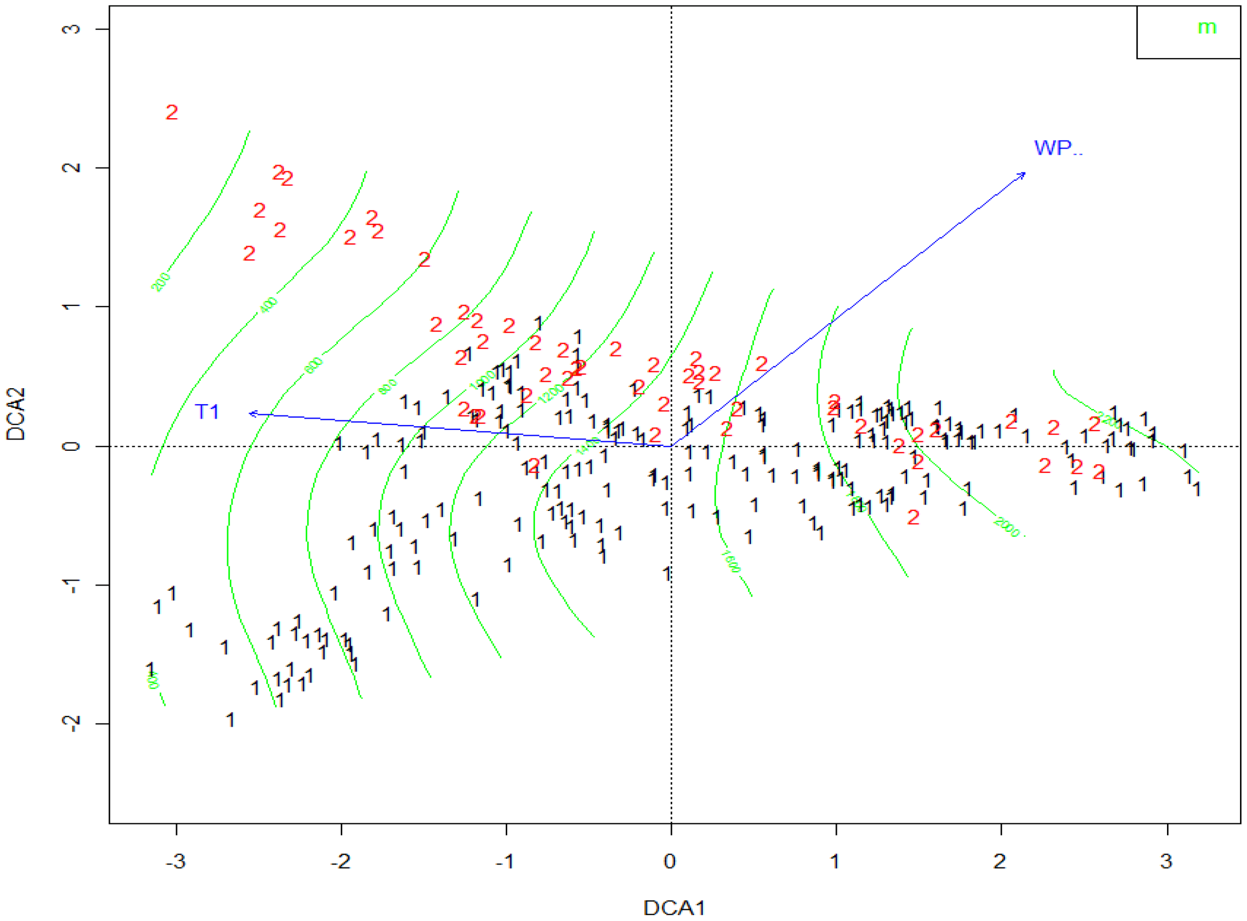
3.3. Relationship between Vegetation and Environmental Factors

DCA was based on data from 891 relevés, which included a total of 1504 vascular plant species. The result of DCA shows the length, the eigenvalues (Table 1) and the Correlation value of environment factors (Table 2) with each axis. The distribution of vegetation units in Southern Taiwan is structured strongly by the altitude, January temperature (T1) and winter precipitation (WP) gradient by DCA (Figure 4).
Because the length of all three axis were more than four SD, the species composition of relevés are different in two side of axis. The results were compared with the vegetation types. Species were classified after dividing the study area into east and west sides for each vegetation zone (Table 3). High fidelity species in study area of the southwestern side include Prunus phaeosticta, Turpinia formosana, Litsea akoensis, Polygonum chinense, Camellia sinensis f. formosensis, Ilex asprella, Maesa perlaria var. formosana, Eriobotrya deflexa, Strobilanthes cusia, Wendlandia uvariifolia and Pittosporum illicioides. High fidelity species in the southeastern side were as Schima superba var. kankaoensis, Calamus quiquesetinervius, Turpinia ternata, Psychotria serpens, Selaginella delicatula, Ventilago elegans, Syzygium euphlebium, Ficus fistulosa, Antidesma hiiranense, Wendlandia formosana, Schefflera octophylla, Magnolia kachirachirai, Ormosia hengchuniana, Vandenboschia auriculata, Machilus thunbergii, Piper kadsura, Arenga tremula, Pileostegia viburnoides, Alpinia pricei, Eria ovata, Pothos chinensis, Bridelia balansae and Callicarpa remotiserrulata. The result from classification were similar in the two sides. For example, Antidesmo hiiranenseSchimetum kankaoensis and Arengo tremulaeFicetum irisanae were found in the study area of the southeastern side only, and habitat of associations was moist. On the southwestern side, Archidendro lucidaeWendlandietum uvariifoliae, Camellio salicifoliaePrunetum phaeostictae, Carpino kawakamiiEriobotryetum deflexa, Zanthoxylo pistaciiflorumFraxinuetum insularis, Litseo akoensisPsychotrietum rubrae and Kleinhovio hospitaeLitseetum hypophaeae were found in this side only, and habitat of associations was dry in winter and landslide. We divided vegetation types into east and west zones using DCA (Figure 5).
On the western side, the Quercus zone was located at approximately 1400 m asl, the MachilusCastanopsis zone was located 600 m asl or higher, and only remnants of the FicusMachilus zone were located in a valley at 400 m or lower. On the eastern side, the Quercus zone was located at more than 1000 m asl, the MachilusCastanopsis zone was located 400 m asl or higher, and the FicusMachilus zone was distributed in a forest area at 400 m or lower (Figure 6).
The results indicated vegetation of the east side was lower than the west side of the study area, with obvious vegetation compression in the forest on the east side. The effect of the altitude distribution on the east and west sides of the Quercus zone at more than 1400 m asl was insignificant. The natural elevation drop on the east side of the MachilusCastanopsis zone significantly affected the compression. The DCA results showed that the main environmental factors affecting variation in vegetation distribution by elevation gradient between the east and west sides were winter rainfall (WP) and the average January temperature (T1).

4. Discussion

Relationship between Distribution of Vegetation and Environmental Factors

The study area included to the west side and east side other of Taiwan Central Mountain Range [38]. Theoretically, different geographies and climate zones have different vegetation types, but the Quercus zone had similar associations in the two regions. For example, the variety of types in the high altitudes of the Quercus zone was limited, including vegetation such as Tsugo formosanaeChamaecyparidetum formosanae, Vaccinio lasiostemonisTsugetum formosanae, and Schefflero taiwanianaeChamaecyparidetum formosensis. Although temperature and moisture were similar in these two regions, the average rainfall on the west side was less than the east side of the Quercus zone. That was caused by the factor compensation effect (altitude, fog, and temperature) in the west side, which maintains the moisture content of this area at a certain level [39]. The climate of the west and east sides of the Quercus zone are different, due to winter rainfall being greater on the east side that is no dry season in southeastern Taiwan.. Although rainfall concentrated along east side and Hengchun Peninsula in summer, a phenomenon similar to the wet season persists because of the northeast monsoon. In the west side, the rainfall mainly results from the southwest monsoon on the west side and from typhoons in summer. In addition, heavy rainfall caused by convection of afternoon heat and the temperature was high in the west side. Moreover, the barrier of the Central Mountain Range produces a rain shadow effect, with less precipitation than summer. Several deciduous species, such as Albizia procera, Castanopsis formosana and Kleinhovia hospita, and several deciduous associations, such as Carpino kawakamiiEriobotryetum deflexa, Zanthoxylo pistaciiflorumFraxinuetum insularis, Litseo akoensisPsychotrietum rubrae and Kleinhovio hospitaeLitseetum hypophaeae, can be found on the west side, corresponding to the seasonal deciduous vegetation [40].
The east side is more humid during the winter due to the northeast monsoon, which is characterized by increased airflow. Moreover, the northeast is not as humid as the southeast. However, the terrain along the southern tip of the Central Mountain Range causes east winds to ascend the slope. The physiognomy of this forest zone is caused primarily by factors such as wind speed and the ridgeline slope. Because of the southwest and northeast monsoons the composition and distribution of species from Beidawushan to Chinshueiying include tropical cloud vegetation types such as Grammitidaceae and Hymenophyllaceae that are tropical mountain cloud forest species [41]. The area between Dahanshan and Chachayalaishan connects the crucial transition zone between Beidawushan alpine plants and Hengchun Peninsula species [3]. In the west side of the study area, the clouds begin at approximately 1000 m asl [42], whereas in the southwest of the Hengchun Peninsula, the clouds begin at 500 m [43]. We could find some deciduous associations in the west side [44,45] and found vegetation settlement on the east side (Figure 6). Clouds on the mountains of the west side have been gradually moving to the climatic conditions east side that has no dry season [46], but west lowlands were different [44]. Due to its special habitat, the montane cloud band on the east side that includes many rare species in narrow habitats [47]. We found similar results by associations. The east side of the study area comprised associations such as Antidesmo hiiranense–Schimetum kankaoensis, Arengo tremulae–Ficetum irisanae, Amentotaxo formosanae–Litsetum acutivenae, Pasanio konishii–Machiletum thunbergii, and Myrico adenophorae–Rhododendretum formosanum. The northeast monsoon, which is experienced year-round in this area, induces this particular environmental habitat with its accompanying wind rush and relatively low temperature and humidity, in addition to compressing the elevation range of each forest. In the low-altitude mountainous terrain of the study area’s west side, we observed the deciduous vegetation association of Kleinhovio hospitae–Litseetum hypophaeae, Carpino kawakamii–Eriobotryetum deflexa and Zanthoxylo pistaciiflorum–Fraxinuetum insularis; however, these were not observed on the east side. Many species of high altitude occur in Nandawushan and continue to the southern boundary of the habitat [42], such as Juniperus formosana, Tsuga chinensis var. formosana, Grammitis nuda, Hymenophyllum devolii, Swertia changii and Sorbus randaiensis, and they are particularly apparent in the southern section of the Central Mountain Range, from Beidawushan to Chinshueiying.
Montane ecosystems are thought to be at disproportionate risk to climate change due to temperature sensitivity and restricted geographical ranges [48]. Southern Taiwan is a mountainous area located on the Tropic of Cancer that includes different topography (mountain, valley, Landslides, etc.), habitat (moisture, dry, etc.) and rare species that include tropical and subtropical species (Supplementary Table S1) in a small geographic area. There is high diversity by many different species group and associations in the study area. Careful planning is needed to sustain diversity and habitat, particularly for rare associations.

5. Conclusions

We identified 179 families, 810 genera, and 1897 species (Supplementary Table S1), including 291 rare species (Supplementary Table S1), in the study area, which comprised 891 plant plots. A classification system that employed vegetation taxa and cocktail determination key identified twenty associations. By comparing the vegetation types and species, we determined the distribution status of each vegetation zone. More of the west side than the east side of the study area was at a higher altitude, and the vegetation experienced significant compression. The natural elevation drop on the east side of the Machilus–Castanopsis zone significantly affected the compression. Winter rainfall and the average January temperature were the main environmental factors affecting variation in vegetation distribution by elevation gradient in the study area. The particular association types on the eastern side of the study area are attributable to the northeast monsoon experienced year-round in this area, which causes relatively low temperature and humidity and wind rush, as well as the compression of the elevation range in each forest. The deciduous vegetation exists only on the western of the mountains.

Supplementary Materials

The following are available online at www.mdpi.com/1999-4907/7/8/179/s1, Table S1: Plant list in study area, Table S2: Synoptic table of associations.

Acknowledgments

This study would not have been possible without the hard fieldwork of dedicated researchers who collected vegetation plots data, often in poorly accessible and remote areas. We gratefully acknowledge the Forestry Bureau, Council of Agriculture, Executive Yuan, Taiwan, for support in the use of vegetation data. The formalized classification used in this study was inspired by Ching-Feng Li and David Zelený. We also appreciated his very helpful comments and those from reviewers and editors.

Author Contributions

Yi-Shin Chian conceived and designed the study, carried out fieldwork, analyzed data and prepared the manuscript. Ching-Long Yeh and Chih-Chiang Wang supervised the study, analyzed data, and reviewed and edited the work.

Conflicts of Interest

The authors declare no conflict of interest.

References

  1. Li, C.F.; Chytrý, M.; Zeleny, D.; Chen, M.Y.; Chen, T.Y.; Chiou, C.R.; Hsia, Y.J.; Liu, H.Y.; Yang, S.Z.; Yeh, C.L.; et al. Classification of Taiwan forest vegetation. Appl. Veg. Sci. 2013, 16, 698–719. [Google Scholar] [CrossRef]
  2. Su, H.J. Studies on the climate and vegetation types of the natural forests in Taiwan (III): A scheme of geographical climatic regions. Q. J. Chin. For. 1985, 18, 33–44. [Google Scholar]
  3. Chen, C.F. Studies on Vegetation Ecology between Chinshuiying and Chachayalaishan Areas of Southern Taiwan. Master’s Thesis, NPUST, Pingtung, Taiwan, 2006. [Google Scholar]
  4. Chian, Y.S.; Liao, C.F.; Yeh, C.L. Vegetation Analysis of Shihkochiehshan Area. Hwa Kang J Agric. 2010, 25, 15–40. [Google Scholar]
  5. Chian, Y.S.; Liu, H.Y.; Yeh, C.L.; Liao, C.F. Vegetation classification and mapping of Ailao river basin. Q. J. For. Res. 2010, 32, 1–14. [Google Scholar]
  6. Lo, K.P. Classification and Ordination of Plant Community on the Kutzulun River Basin of Eastern Taiwan. Master’s Thesis, NPUST, Pingtung, Taiwan, 2006. [Google Scholar]
  7. Wang, C.C.; Ou, C.H.; Lu, K.C.; Yeh, C.L.; Chiu, C.A.; Fan, K.C.; Chian, Y.S. The studies on flora and vegetation of Shuangkueihu wildlife important habitat. Q. J. Chin. For. 2014, 47, 27–36. [Google Scholar]
  8. Yeh, C.L.; Liao, J.H. Study on vegetation diversity of Peitawushan. J. Exp. For. NTU 2007, 21, 117–132. [Google Scholar]
  9. Yeh, C.L.; Liao, J.H. Vegetation ecology of Peitawushan in Pingtung County. Q. J. Chin. For. 2008, 41, 165–179. [Google Scholar]
  10. Yeh, C.L.; Liao, C.C. Vegetation mapping of the Peitawushan. Q. J. Chin. For. 2009, 42, 319–333. [Google Scholar]
  11. Yeh, Q.W.; Hsieh, S.I.; Chen, T.Y.; Yeh, C.L.; Lee, C.T. Study of vegetation diversity at Lilung mountains. Q. J. Chin. For. 2012, 45, 451–470. [Google Scholar]
  12. Li, C.F.; Zeleny, D.; Chytrý, M.; Chen, M.Y.; Chen, T.Y.; Chiou, C.R.; Hsia, Y.J.; Liu, H.Y.; Yang, S.Z.; Yeh, C.L.; et al. Chamaecyparis montane cloud forest in Taiwan: Ecology and vegetation classification. Ecol. Res. 2015, 30, 771–791. [Google Scholar] [CrossRef]
  13. Lin, C.T.; Li, C.F.; David, Z.; Chytrý, M.; Yukito, N.; Chen, M.Y.; Chen, T.Y.; Hsia, Y.J.; Hsieh, C.F.; Liu, H.Y.; et al. Classification of the high-mountain coniferous forests in Taiwan. Folia Geobot. 2012, 47, 373–401. [Google Scholar] [CrossRef]
  14. Hukusima, T.; Lu, S.Y.; Matsui, T.; Nishio, T.; Liu, C.L.; Pignatti, S. Phytosociology of Fagus hayatae forests in Taiwan. Rend. Lincei 2005, 16, 171–189. [Google Scholar] [CrossRef]
  15. Chytrý, M.; Schaminée, J.H.J.; Schwabe, A. Vegetation survey: A new focus for Applied Vegetation Science. Appl. Veg. Sci. 2011, 14, 435–439. [Google Scholar] [CrossRef]
  16. Legendre, P.; Legendre, L. Numerical Ecology, 2nd ed.; Elsevier: Amsterdam, The Netherlands, 1998. [Google Scholar]
  17. Hill, M.O. TWINSPAN—A FORTRAN Program for Arranging Multivariate Data in an Ordered Two-Way Table by Classification of the Individuals and Attributes; Cornell University: Ithaca, NY, USA, 1979. [Google Scholar]
  18. Bruelheide, H. Using formal logic to classify vegetation. Folia Geobot. 1997, 32, 41–46. [Google Scholar] [CrossRef]
  19. Bruelheide, H. A new measure of fidelity and its application to defining species groups. J. Veg. Sci. 2000, 11, 167–178. [Google Scholar] [CrossRef]
  20. Bruelheide, H.; Chytrý, M. Towards unification of national vegetation classifications: A comparison of two methods for analysis of large data sets. J. Veg. Sci. 2000, 11, 295–306. [Google Scholar] [CrossRef]
  21. Koci, M.; Chytrý, M.; Tichý, L. Formalized reproduction of an expert-based phytosociological classification: A case study of subalpine tall-forb vegetation. J. Veg. Sci. 2003, 14, 601–610. [Google Scholar] [CrossRef]
  22. Janišová, M.; Dúbravková, D. Formalized classification of rocky Pannonian grasslands and dealpine Sesleria-dominated grasslands in Slovakia using a hierarchical expert system. Phytocoenologia 2010, 40, 267–291. [Google Scholar] [CrossRef]
  23. Landucci, F.; Tichý, L.; Šumberová, K.; Chytrý, M. Formalized classification of species-poor vegetation: A proposal of a consistent protocol for aquatic vegetation. J. Veg. Sci. 2015, 26, 791–803. [Google Scholar] [CrossRef]
  24. Yang, W.F. Hydrological year book of Taiwan Republic of China; Water Resources Agency Ministry of Economic Affairs: Taipei, Taiwan, 2014. [Google Scholar]
  25. Forestry Bureau, Council of Agriculture, Executive Yuan. Available online: http://www.forest.gov.tw/0001493 (accessed on 5 July 2016).
  26. Su, H.-J. Studies on the climate and vegetation types of the natural forests in Taiwan (II): Altitudinal vegetation zones in relation to temperature gradient. Q. J. Chin. For. 1984, 17, 57–73. [Google Scholar]
  27. Chiou, C.R.; Hsieh, C.F.; Wang, J.C.; Chen, M.Y.; Liu, H.Y.; Yeh, C.L.; Yang, S.Z.; Chen, T.Y.; Hsia, Y.J.; Song, G.Z.M. The first national vegetation inventory in Taiwan. Taiwan J. For. Sci. 2009, 24, 295–302. [Google Scholar]
  28. Huang, T.C.; Hsieh, C.F. Flora of Taiwan, 2nd ed.; National Taiwan University: Taipei, Taiwan, 1994; Volume I–VI. [Google Scholar]
  29. WorldClim—Global Climate Data. Available online: http://www.worldclim.org (accessed on 5 October 2014).
  30. Mueller-Dombois, D.; Ellenberg, H. Aims and Methods of Vegetation Ecology; Wiley & Sons: New York, NY, USA, 1974. [Google Scholar]
  31. Su, H.J.; Liou, C.Y. The Floristic-sociological Approach of Vegetation Classification. J. Exp. For. NTU 2004, 18, 129–151. [Google Scholar]
  32. Landucci, F.; Gigante, D.; Venanzoni, R.; Chytrý, M. Wetland vegetation of the class Phragmito-Magno-Caricetea in central Italy. Phytocoenologia 2013, 43, 67–100. [Google Scholar] [CrossRef]
  33. Kruskal, J.B. Nonmetric multidimensional scaling: A numerical method. Psychometrika 1964, 29, 115–129. [Google Scholar] [CrossRef]
  34. Tichý, L. JUICE, Software for vegetation classification. J. Veg. Sci. 2002, 13, 451–453. [Google Scholar] [CrossRef]
  35. R Core Team. R: A Language and Environment for Statistical Computing. R Foundation for Statistical Computing: Vienna, Austria, 2013. Available online: http://www.R-project.org (accessed on 30 April 2013).
  36. Oksanen, J.; Blanchet, F.G.; Kindt, R.; Legendre, P.; Minchin, P.R.; O’Hara, R.B.; Simpson, G.L.; Solymos, P.; Stevens, M.H.H.; Wagner, H. Vegan: Community Ecology Package. R Package Version 2.0-6. 2013. Available online: http://CRAN.R-project.org/package=vegan (accessed on 30 April 2013).
  37. Su, H.J. The diversification and synthesis of vegetation classification. J. Exp. For. NTU 2002, 16, 269–282. [Google Scholar]
  38. Su, H.J. A geographical data organization system for the botanical inventory of Taiwan. Institute of Botany, Academia Sinica. Monogr. Ser. 1992, 12, 23–36. [Google Scholar]
  39. Chiu, C.A.; Lin, P.H.; Lu, K.C. GIS-based tests for quality control of meteorological data and spatial interpolation of climate data. MRD 2009, 29, 339–349. [Google Scholar] [CrossRef]
  40. Chian, Y.S.; Liao, C.F.; Yeh, C.L.; Wang, C.C. The Study of Vegetation in Shihbaluohanshan Natural Reserve Area. Q. J. Chin. For. 2012, 45, 299–308. [Google Scholar]
  41. Wang, J.C.; Chiou, W.L.; Chang, H.M. A Preliminary Red List of Taiwanese Vascular Plants; Endemic Species Research Institute and Taiwan Society of Plant Systematics: Taipei, Taiwan, 2012. [Google Scholar]
  42. Chen, S.Y. Vegetation Ecology Along Varus River to Nantawushan in Pingtung County. Master’s Thesis, NPUST, Pingtung, Taiwan, 2014. [Google Scholar]
  43. Liu, C.P.; Yeh, C.L.; Chen, T.Y. Natural vegetation classification system of the Hengchun peninsula. J. Exp. For. NTU 2006, 20, 133–152. [Google Scholar]
  44. Chiu, C.A.; Wang, C.C.; Lu, K.C.; Lin, P.H.; Tzeng, H.Y. Examination of semi-arid regions and potential savanna vegetation in Taiwan. Taiwan J. For. Sci. 2008, 23, 23–36. [Google Scholar]
  45. Lin, C.J. Conferring the Composition and Distribution of Vegetation Diversity in Taiwan. Master’s Thesis, NTU, Taipei, Taiwan, 2009. [Google Scholar]
  46. Chiu, C.A.; Lin, P.H.; Tsai, C.Y. Spatio-temporal variation and monsoon effect on the temperature lapse rate of a subtropical island. TAO Sci. 2014, 20, 203–217. [Google Scholar] [CrossRef]
  47. Wang, J.C.; Huang, S.; Lue, K.Y.; Hsu, Y.F.; Chen, S.H. The Investigation on the Biota of Tawushan Nature Preserve—Jinlun Watershed; Taitung Forest District Office, Bureau of Forestry, Council of Agriculture Executive Yuan: Taipei, Taiwan, 2003. [Google Scholar]
  48. Sarah, J.I.; Regan, E.; Dov, F.S.; James, R. Niche expansion and temperature sensitivity of tropical African montane forests. Glob. Ecol. Biogeogr. 2016, 25, 693–703. [Google Scholar] [Green Version]
Figure 1. Vegetation relevés in study area (Resource: https://www.google.com/maps).
Forests 07 00179 g001
Figure 2. Distribution of associations in western side (TsuCha: Tsugo formosanaeChamaecyparidetum formosanae; SchCha: Schefflero taiwanianaeChamaecyparidetum formosanae; VacTsu: Vaccinio lasiostemonisTsugetum formosanae; AraCha: Arachniodo rhomboideaeChamaecyparidetum formosensis; CasCha: Castanopsio carlesiiChamaecyparidetum formosensis; RhoDen: Rhododendro formosanaeDendropanacetum dentigeri; TetMac: Tetrastigmo umbellateMachilietum japonicae; MyrRho: Myrico adenophoraeRhododendretum formosanum; CarEri: Carpino kawakamiiEriobotryetum deflexa; PasMac: Pasanio konishiiMachiletum thunbergii; CamPru: Camellio salicifoliaePrunetum phaeostictae; TriEng: Tricalysio dubiaeEngelhardietum roxburghianae; ZanFra: Zanthoxylo pistaciiflorumFraxinuetum insularis; GlyTur: Glycosmio citrifoliaeTurpinietum formosanae; AmeLit: Amentotaxo formosanaeLitsetum acutivenae; ArcWen: Archidendro lucidaeWendlandietum uvariifoliae; KleLit: Kleinhovio hospitaeLitseetum hypophaeae; LitPsy: Litseo akoensisPsychotrietum rubrae).
Forests 07 00179 g002
Figure 3. Distribution of associations in eastern side (TsuCha: Tsugo formosanaeChamaecyparidetum formosanae; SchCha: Schefflero taiwanianaeChamaecyparidetum formosensis; VacTsu: Vaccinio lasiostemonisTsugetum formosanae; CasCha: Castanopsio carlesiiChamaecyparidetum formosensis; RhoDen: Rhododendro formosanaeDendropanacetum dentigeri; MyrRho: Myrico adenophoraeRhododendretum formosanum; TetMac: Tetrastigmo umbellateMachilietum japonicae; AraCha: Arachniodo rhomboideaeChamaecyparidetum formosensis; PasMac: Pasanio konishiiMachiletum thunbergii; GlyTur: Glycosmio citrifoliaeTurpinietum formosanae; AmeLit: Amentotaxo formosanaeLitsetum acutivenae; TriEng: Tricalysio dubiaeEngelhardietum roxburghianae; AntSch: Antidesmo hiiranenseSchimetum kankaoensis; AreFic: Arengo tremulaeFicetum irisanae).
Forests 07 00179 g003
Figure 4. Distribution of relevés and environment factors in detrended correspondence analysis (DCA) (T1: temperature of January; WP: precipitation in winter; Topo: topography; Altitude: Altitude).
Forests 07 00179 g004
Figure 5. Relevés of different area and environment factors in DCA (1: indicates the relevés of western area of Southern Taiwan; 2: indicates the relevés of eastern area of Southern Taiwan; T1: temperature of January; WP: precipitation in winter; contour line: altitude (m)).
Forests 07 00179 g005
Figure 6. Distribution of different vegetation zones with different climatic regions in Taiwan. (TWS: Tsuga zone in southwestern climatic regions; TCW: Tsuga zone in central west climatic regions; TES: Tsuga zone in southeastern climatic regions; TEN: Tsuga zone in northeastern climatic regions; QWS: Quercus zone in southwestern climatic regions; QCW: Quercus zone in central west climatic regions; QES: Quercus zone in southeastern climatic regions; QEN: Quercus zone in northeastern climatic regions; MCWS: MachilusCastanopsis zone in southwestern climatic regions; MCCW: MachilusCastanopsis zone in central west climatic regions; MCES: MachilusCastanopsis zone in southeastern climatic regions; MCEN: MachilusCastanopsis zone in northeastern climatic regions; FMWS: FicusMachilus zone in southwestern climatic regions; FMCW: FicusMachilus zone in central west climatic regions; FMES: FicusMachilus zone in southeastern climatic regions).
Forests 07 00179 g006
Table 1. Results of the length and the eigenvalues with each axis in detrended correspondence analysis (DCA).
Axis 1Axis 2Axis 3
eigenvalue0.7430.4310.343
length8.1595.0745.071
Monte Carlo significance testing
p value0.002 **0.0620.086
** p ≤ 0.01.
Table 2. Correlation value of environment factors and axis in DCA.
VariableAxis 1Axis 2Axis 3
Altitude−0.915 **−0.109−0.112
Canopy cover−0.057−0.046−0.099
Slope0.15−0.323−0.320
Rock cover0.069−0.2610.26
Rockiness0.375−0.211−0.497
WP−0.415 **−0.814 **−0.006
T10.402 **−0.0230.172
Topography0.3430.368 **−0.338
** p ≤ 0.01.
Table 3. Diagnostic species of southwestern and southeastern climatic regions. Values are the percentage constancy and species are sorted by decreasing fidelity (Φ).
Scientific NameEcoclimatic Regions
SouthwesternSoutheastern
Prunus phaeosticta38.2
Litsea akoensis34.8
Turpinia formosana32.6
Camellia sinensis f. formosana27.5
Ilex asprella25.2
Maesa perlaria v. formosana22.7
Pittosporum illicioides21.3
Polygonum chinense21.2
Wendlandia uvariifolia20.8
Schima superba v. kankaoensis 43.2
Psychotria serpens 41.9
Calamus quiquesetinervius 41.4
Syzygium euphlebium 37.1
Turpinia ternata 36.8
Ventilago elegans 36.4
Antidesma hiiranense 35.5
Wendlandia formosana 34.2
Ficus fistulosa 32.9
Selaginella delicatula 31.8
Ormosia hengchuniana 31.5
Alpinia pricei 30.8
Callicarpa remotiserrulata 30.1

