1. Introduction
Forested watersheds provide essential ecosystem services such as the provision of high quality water. As watershed land becomes increasingly urbanized, valuable filtration services once provided by the forested catchments are lost. Drinking water treatment authorities in locations such as Boston, MA, Portland, OR, and New York, NY recognize the water quality benefits from forested catchments and actively purchase natural land in supplying watersheds. For example, an improvement in turbidity of 30% saved $90,000 to $553,000 per year for drinking water treatment in the Neuse Basin of North Carolina [
1]. An analysis of 27 US water suppliers concluded that a reduction from 60% to 10% forest land increased drinking water treatment costs by 211% [
2]. The progressive loss of forest ecosystem services risks harm to human health through lowered drinking water quality, as well as increased drinking water treatment cost [
2].
One water quality variable of particular interest to water providers is total organic carbon (TOC) because of disinfection byproduct (DBP) formation. Source water TOC is a good indicator of the amount of DBP that may form as a result of chemical disinfection [
3]. TOC reacts with chlorine during the disinfection phase of water treatment to form DBPs. Several DBPs have been identified by the US Environmental Protection Agency (US EPA) as probable human carcinogens. Evidence is insufficient to support a causal relationship between chlorinated drinking water and cancer. However, the US EPA concluded that epidemiology studies support a potential association between exposure to chlorinated drinking water and bladder cancer leading to the introduction of the Stage 2 DBP rule. The American Cancer Society (ACS) estimates that there will be about 74,000 new cases of bladder cancer diagnosed in the United States each year [
4]. Approximately 2260 drinking water treatment plants nationwide are estimated to make treatment technology changes to comply with the Stage 2 DBP rule [
5]. An alternate method to mitigate DBP formation is the management of watershed land to reduce source water TOC [
6,
7].
While water providers are struggling to maintain low source water TOC concentrations and minimize DBP formation potential, many source water catchments are undergoing rapid forest to urban land use change [
8]. The impact of forest to urban land conversion on lotic TOC concentrations varies, however literature reports elevated TN and TP concentrations in urban streams [
9]. Elevated nutrient concentrations can support increased algae growth thereby increasing overall TOC in reservoirs regardless of the allochthonous contribution.
Here we assess the impact of forest to urban land conversion on reservoir TOC concentrations at Converse Reservoir, which supplies the drinking water for the City of Mobile, Alabama through the Mobile Area Water and Sewer Systems (MAWSS). MAWSS is one of the >2000 water treatment facilities nationally making changes to comply with the Stage 2 DBP rule because of existing elevated TOC concentrations. Rapid urbanization is occurring in the contributing watershed and urbanization projections concur that the watershed will undergo significant urbanization in the coming decades [
8,
10,
11]. Like other urbanizing watersheds, the concern is that Mobile source water TOC concentrations may increase as watershed urbanization continues.
Along with watershed forest to urban land conversion, changes in reservoir concentrations may be related to variations in ocean-atmosphere oscillation, known as El Niño Southern Oscillation (ENSO). In southern Alabama, interannual variations in precipitation and streamflow are related to ENSO. El Niño events, which occur every 2 to 10 years, are caused by positive sea surface temperature anomalies. Conversely, La Niña events are caused by negative sea surface temperature anomalies (SST). Strong relationships have been established between ENSO and precipitation in certain regions including southern Alabama, ENSO and water temperature and ENSO and streamflow in the Converse watershed [
12]. El Niño seasonal precipitation has been shown to be higher than normal and La Niña precipitation in the three southern climate divisions in Alabama [
13]. Precipitation during JFM in the La Niña phase is lower than normal for the southern climate divisions [
14]. TOC loads from watershed sources have also been linked with ENSO phase and reflect a seasonal component wherein El Niño TOC loads are higher than neutral or La Niña phase loads during Jan-Mar, but lower than La Niña during Aug-Oct [
15]. During El Niño events in January to March, the higher precipitation and streamflow could lead to higher nutrient loads delivered to Converse or similar reservoirs.
Changes in precipitation and temperature can have a significant effect on surface water quality [
16]. There is a relationship between ENSO phase, precipitation and streamflow in Alabama [
13]. Seasonal streamflow is related to both ENSO phase and surface water nutrient loadings [
17]. ENSO phase has been found to have strong nitrate concentration, streamflow and precipitation predictive effects in a southeastern U.S. watershed [
18]. ENSO phase has been linked to flow, stream temperature, dissolved oxygen and water quality parameters in southeast Alabama and related to ENSO phase for predicting periods restrictive to point-source discharge to limit water quality impairment [
19].
Changes in land use can significantly alter the quality of adjacent surface waters [
16]. Increased nutrient concentrations are associated with urban streams [
9]. However, the relationship between land use and water quality can vary regionally and even on a stream-by-stream basis due to many factors including land use intensity, geology, precipitation patterns. In the greater Converse Watershed urban subwatersheds had higher TP and TN loads and concentrations than undisturbed forested watershed [
20,
21]. Watershed simulations also support elevated post-urbanization nutrient concentrations [
22]. Converse Reservoir response to changing land use was evaluated previously using a BATHTUB reservoir model [
23]. Modelers found increased TP and TN loads, changes in trophic state and increased algal blooms.
This study improves upon previous research by evaluating the impacts of two major stressors to water resources of Converse Reservoir simultaneously. Here we concurrently evaluate the impacts of watershed urbanization and ENSO phase on reservoir water quality. The modeling utilized in this study expands previous efforts by utilizing coupled watershed and reservoir models rather than the BATHTUB model [
23], simulating the entire year, rather than April to September only, and using a realistic estimate of watershed urbanization, rather than the expectation of 100% land development. This study builds upon previous efforts [
15,
19] by relating ENSO phase to reservoir, rather than stream, water quality. Reservoir modeling studies most often evaluate nitrogen and phosphorous fractions, but here we simulate TOC, the variable of most interest to drinking water managers. The rigor of modeling efforts used here, the relation to multiple watershed stressors and the incorporation of reservoir water quality serve to enhance our understanding of the relationship between urbanization, ENSO phase and water quality. To evaluate the impact of forest to urban land conversion and ENSO phase on reservoir water quality, linked watershed [
24] and reservoir [
25] models were used. Daily nutrient concentrations and streamflow from watershed simulations provide input data to estimate the effects on nutrient and TOC concentrations within the reservoir under base and future land use conditions. Total (1992 to 2005) and monthly median TOC concentrations at a source water intake from base and future scenarios were compared. Additionally, six ENSO indices were correlated with (1) measured TOC; (2) simulated pre-urbanization monthly nutrient and reservoir TOC concentrations; and (3) simulated post- urbanization monthly nutrient and TOC concentrations.
The objectives of this study were to (1) utilize linked watershed and reservoir models to test the hypothesis that watershed nutrient loads during future scenarios will lead to increased TOC concentrations and algae growth at the source water intake when compared with base scenarios; (2) evaluate the influence of anticipated forest to urban land use change in terms of the daily and monthly changes in source water nutrient and TOC concentrations; and (3) evaluate the influence of ENSO phase on measured TOC and simulated pre- and post- urbanization TN, TP, chlorophyll-a and TOC concentrations.
Study Area
Converse Reservoir supplies the majority of drinking water for the City of Mobile, Alabama through the Mobile Area Water and Sewer Service (MAWSS). Past concerns about the quality of Converse Reservoir as a supply source for drinking water prompted various scientific investigations [
20,
21,
23,
26,
27,
28]. Tributary and reservoir water quality data were collected by the United States Geological Survey (USGS), Auburn University (AU) and MAWSS under various sampling programs beginning in 1990.
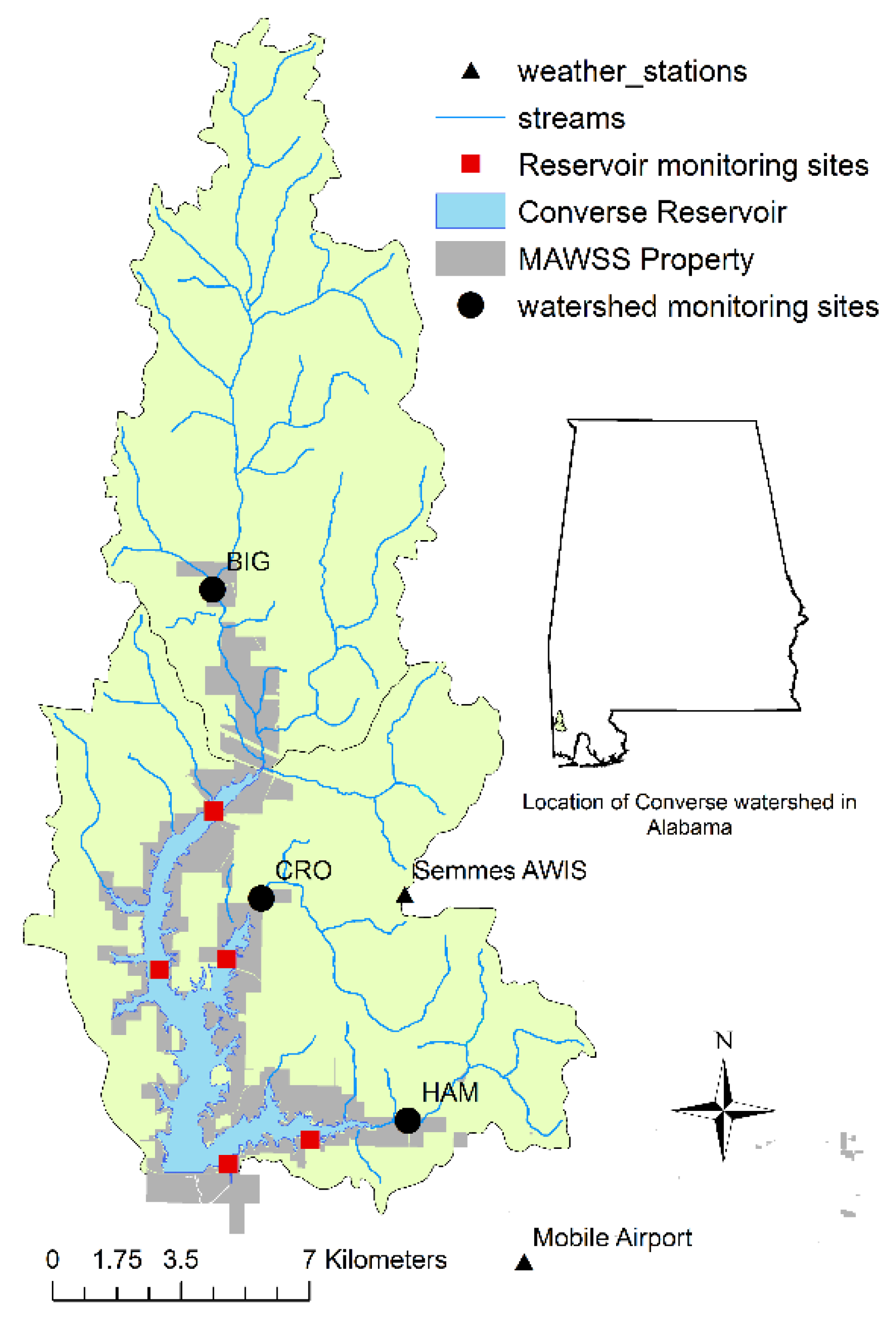
Converse Reservoir was formed in 1952 by impoundment of Big Creek in Mobile County, Alabama with a 37 m high earthen dam. The physical characteristics of the reservoir include: volume 64,100,000 m
3, surface area 14.6 km
2, mean depth 4.4 m, and maximum depth 15.2 m. Converse Reservoir has two main branches, Big Creek, which is the reservoir mainstem, and Hamilton Creek, which contains the drinking water intake 4.8 km from the reservoir mainstem (
Figure 1).
Figure 1.
Monitoring locations, weather stations, and Mobile Area Water and Sewer System (MAWSS) property in the Converse watershed and reservoir located in southwestern Alabama.
Figure 1.
Monitoring locations, weather stations, and Mobile Area Water and Sewer System (MAWSS) property in the Converse watershed and reservoir located in southwestern Alabama.
Precipitation near the study area is some of the highest in the US, with a 48-year (1957–2005) median monthly precipitation of 12.40 cm (1953–2005). A firm-yield analysis of Converse Reservoir estimated ~5% of the total reservoir volume is from groundwater [
29]. Streamflow from the 3 major tributaries has been monitored by USGS gauging stations since 1990.
A 267 km
2 watershed drains to the reservoir. Within the watershed there are wetlands, forests, dairy farms, plant nurseries, pecan groves and residential areas using septic tanks for sewage disposal. Watershed soils are generally acidic, low in organic matter content and composed of fine sand or loamy find sand [
30]. The eastern watershed boundary extends to within 500 m of Mobile, Alabama city limits. Local, regional and national urbanization studies concur that the study area will likely experience significant urbanization in the coming decades [
8,
10,
11,
31].
4. Conclusions
Simulated forest to urban land conversion of 52 km2 in the 267 km2 Converse Reservoir watershed increased monthly median TN, TP, TOC and chlorophyll-a concentrations (p < 0.05) at a source water intake located 4.8 km upstream of the mainstem of Converse Reservoir. Expected increases in future TOC concentrations are important due to the potential for increased carcinogenic DBP formation. Simulated forest to urban land conversion to 2020 in the Converse Watershed increased median overall TOC concentrations, calculated from daily concentrations, from 1992 to 2005, by 1.1 mg·L−1 (41%). Total median TOC concentrations (1992 to 2005) increased by 0.02 mg·L−1 km−2 following urbanization. The percent TOC change per area urbanized (%Δ/areaΔ) was 0.8% per km2 urbanized over the 15-year simulation period, indicating that for each km2 of forest land converted to urban land, reservoir TOC concentrations at the source water intake increased 0.8%. Monthly median TOC concentrations between May and October increased between 33% and 49% following urbanization during the same simulation period. Chlorophyll-a, indicating algae growth, accounted for most of the variance (R2 > 0.37; p < 0.05) in simulated TOC concentration between May and November. In early spring (March and April), prior to high algae growth, allochthonous TOC load predicted 47% to 58% of the variance in intake TOC concentration. Simulated urbanization was associated with a significant relationship between chlorophyll-a and intake TOC concentrations earlier in the spring season of most years. It was found that under simulated 1992 land cover conditions, additional drinking water treatment is necessary in 47% of the simulated days between May and October. Reservoir modeling with future land use indicated the need for continuous additional treatment in Converse Reservoir between May and October based on daily TOC concentrations at the drinking water intake. Simulated urbanization indicated the need for continuous additional drinking water treatment between May and October to comply with the Safe Drinking Water Act DBP regulations.
Along with urbanization, climatic factors may influence reservoir nutrient concentrations. Only one of six ENSO indices was associated with measured TOC data. The small negative correlation between ONI and TOC concentrations may suggest higher TOC associated with lower streamflow of La Niña. Simulated TN and TP were correlated with ENSO phase with El Niño events having higher reservoir concentrations. This relationship was not evident in chlorophyll-a or TOC indicating that a delayed response and other factors such as temperature, light and reservoir flushing may have a larger impact on monthly in-reservoir TOC concentrations than TN and TP concentrations in Converse Reservoir. Converse watershed should be managed to retain forest cover. Water providers can use predictions of ENSO phase to estimate changes to streamflow, stream nutrient loads and in-reservoir TN and TP concentrations, thereby minimizing some uncertainty in the provision of potable water.


