
Exploring Local Perspectives for Conservation Planning: A Case Study from a Remote Forest Community in Indonesian Papua

Abstract
:1. Introduction
2. Methods
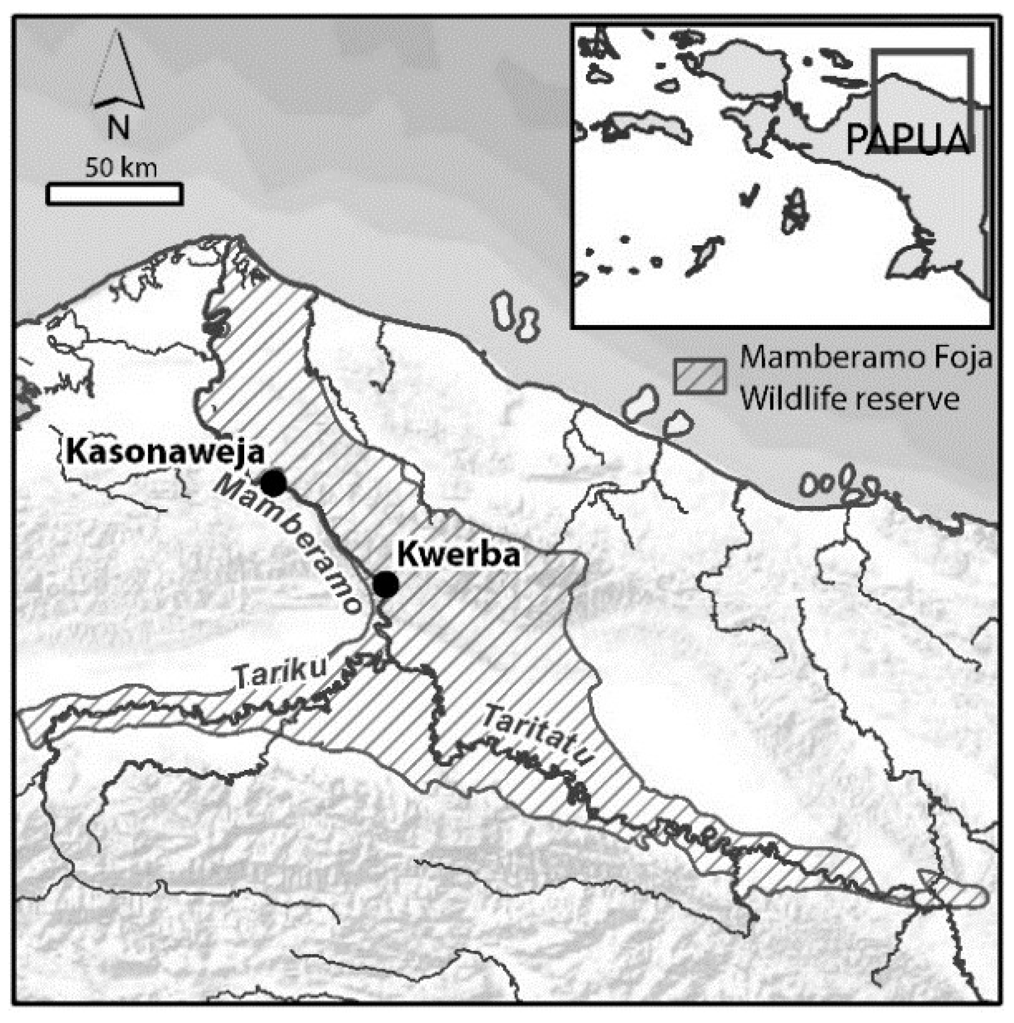
2.1. Study Area
2.2. Community Meetings, Interviews and Household Survey
2.3. Participatory Mapping
2.4. Scoring Exercises
- (1)
- the relative importance of land types, for each use category,
- (2)
- the relative importance of forest types for each use category, and
- (3)
- the relative importance of the ten “most important” species listed for each use category (plants and animals separately). This exercise includes a pre-score of the relative importance of each use category.
3. Results
3.1. Description of Context
3.1.1. Settlement and Population
3.1.2. Livelihoods; Main Sources of Food and Income
3.1.3. Aspirations and Threats to Livelihoods
3.2. Scoring the Importance of Land Types, Forest Types and Species
3.2.1. The Importance of Land Types

| Use Category (Overall Importance Score) | Settlement | Garden | Sago Garden | Sago Hamlet | Old Garden | Old Village | River | Lake | Swamp Forest | Forest | Total |
|---|---|---|---|---|---|---|---|---|---|---|---|
| Food (12 ¼) | 10 ¾ | 15 | 11 ½ | 11 ½ | 4 ¾ | 6 ¾ | 10 ¼ | 9 ¼ | 7 | 13 ¼ | 100 |
| Heavy construction (12 ¼) | 9 | 3 | 10 ¼ | 16 | 15 ¼ | 3 ¼ | 3 ¼ | 2 ¾ | 3 ½ | 33 ¾ | 100 |
| Firewood (10 ¼) | 2 ½ | 25 ¼ | 5 | 5 | 11 ½ | 3 ¾ | 19 ¼ | 4 ½ | 2 ½ | 20 ¾ | 100 |
| Hunting place (8 ¼) | ½ | 1 ¼ | 4 ¼ | 6 ¾ | 3 ¾ | 4 | 24 ¾ | 19 ½ | 2 ¼ | 33 | 100 |
| Boat building (7 ½) | 3 ½ | 4 ¾ | ¼ | ½ | 4 ½ | ¾ | 18 ¼ | 15 ½ | 3 ½ | 48 ½ | 100 |
| Tools (7) | 6 | 4 ¾ | 9 ¾ | 11 | 4 ½ | 1 | 16 ¼ | 7 | 3 ¼ | 36 ½ | 100 |
| Future (7) | 13 ¼ | 7 ¼ | 14 | 13 ¾ | 4 ¾ | 4 ¼ | 9 ¾ | 7 ¾ | 4 ½ | 20 ¾ | 100 |
| Medicine (6 ½) | 14 | 10 ¾ | 5 | 5 ¾ | 7 | 5 ¾ | 11 ¼ | 10 ½ | 6 ¼ | 23 ¾ | 100 |
| Basketry/Cordage (6 ½) | 1 ½ | 2 ¾ | 2 ¼ | 4 | 7 ¾ | 4 ¼ | 8 ¼ | 9 ½ | 6 ¼ | 53 ½ | 100 |
| Marketable items (6) | 10 | 10 | 11 | 10 ½ | 2 ¼ | 3 | 14 ¾ | 15 ½ | 3 ½ | 19 ½ | 100 |
| Hunting tools (5 ¾) | 7 ½ | 6 ¼ | 2 ¾ | 2 ¾ | 5 ¾ | 9 ½ | 8 ¾ | 1 ¾ | 3 ½ | 51 ½ | 100 |
| Light construction (4 ¼) | 5 | 6 ¼ | 5 | 13 ¼ | 19 ¼ | 6 ½ | 5 | 4 | 4 ½ | 31 ¼ | 100 |
| Ornament/Ritual (3 ¾) | 8 ½ | 0 | 2 ½ | 9 ¼ | 6 ¾ | 4 | 4 | 4 ¼ | 2 ¾ | 58 | 100 |
| Recreation (2 ¾) | 24 ½ | 10 ½ | 0 | 0 | 0 | 0 | 22 | 6 ½ | 0 | 36 ½ | 100 |
| Use Categories | Description |
|---|---|
| Food | Primary and secondary foods |
| Heavy construction | Timber for house construction and bridges |
| Firewood | Fuel for cooking, warmth |
| Hunting place | Indirect, benefiting hunting (usually when fruiting) |
| Boat building | Timber for making boats (not oars or poles) |
| Tools | Tools in agriculture, boating, household use |
| Future | General (not explained in detail) |
| Medicine | Medicinal and health related |
| Basketry/Cordage | For weaving or tying |
| Marketable items | Products sold for cash |
| Hunting tools | Spear handle, bait, poison, trap |
| Light construction | For making temporary shelter, chicken or pig runs, fences |
| Ornament/Ritual | Used in ceremony, dress, jewellery and decoration |
| Recreation | For entertainment, rest |
| Land Types | |
| Settlement | Human habitation; semi permanent houses, church, school |
| Garden | Area planted with a mix of annual and perennial species |
| Sago garden | Area planted with sago palms |
| Sago hamlet | This term includes wild stands as well as planted but not maintained sago gardens |
| Old garden | Abandoned garden, where forest has regenerated |
| Old village | Abandoned village (before 1974). Planted fruit trees and sago remained, as well as graves |
| River | Mamberamo and its tributaries |
| Lake | Small waterbodies, scattered around Kwerba |
| Swamp forest | Area of wet, (seasonally) flooded forest |
| Forest | Primary, non-swamp forest |
3.2.2. The Importance of Forest Types
| Use Category (Overall Importance Score) | Primary Forest * | Agathis Forest | Mountain Forest ** | Swamp Forest | Secondary Forest (old Sago) | Secondary Forest (Old Garden) | Total |
|---|---|---|---|---|---|---|---|
| Food (12 ¼) | 28 ¼ | 10 ½ | 12 ¾ | 10 | 24 ½ | 14 | 100 |
| Heavy construction (12 ¼) | 37 | 0 | 9 ¼ | 11 | 29 ¼ | 13 ½ | 100 |
| Firewood (10 ¼) | 30 ½ | 5 ½ | 12 ¾ | 5 | 6 ½ | 39 ¾ | 100 |
| Hunting place (8 ¼) | 50 ½ | 7 ½ | 17 | 8 | 9 ¼ | 7 ¾ | 100 |
| Boat building (7 ½) | 64 ½ | 8 ¼ | 15 | 6 ½ | ½ | 5 ¼ | 100 |
| Tools (7) | 43 ½ | 10 ½ | 16 ¼ | 7 ½ | 8 ½ | 13 ¾ | 100 |
| Future (7) | 27 | 20 ¼ | 18 | 10 ½ | 9 ¾ | 14 ½ | 100 |
| Medicine (6 ½) | 35 ¼ | 10 | 16 ½ | 8 ½ | 14 ¾ | 15 | 100 |
| Basketry/Cordage (6 ½) | 43 ½ | 15 | 12 ¾ | 7 | 9 ¾ | 12 | 100 |
| Marketable items (6) | 46 ¼ | 7 ½ | 22 | 8 ¼ | 10 ¾ | 5 ¼ | 100 |
| Hunting tools (5 ¾) | 43 ¾ | 7 | 13 ¾ | 8 | 8 ¾ | 18 ¾ | 100 |
| Light construction (4 ¼) | 40 ¼ | 8 ¾ | 21 | 5 ¼ | 9 ½ | 15 ¼ | 100 |
| Ornament/Ritual (3 ¾) | 53 ¾ | 6 ¾ | 17 ¼ | 7 ½ | 4 ½ | 10 ¼ | 100 |
| Recreation (2 ¾) | 51 ¾ | 8 | 20 | 6 ½ | 6 | 7 ¾ | 100 |
3.2.3. The Most Important Species
| a | |||||||||||||||||
| TOP 10 Plants Local Name (s) | Overall LUVI | (Total Number of Species Scored = 157), Species Name; Indonesian; English | Food | Heavy Construction | Firewood | Hunting Place | Boat Building | Tools | Future | Medicine | Basketry/Cordage | Marketable Items | Hunting Tool | Light Construction | Ornament/Ritual | Recreation | number of Use Categories/14 |
| Kuikar/kwekar/ kwikar | 9.69 | Calophyllum sp.; kayu bitangur | x | X | x | X | X | x | x | x | x | 9 | |||||
| Wac | 7.93 | Gnetum gnemon L.; melinjo; gnetum/ paddy oats | X | x | x | x | X | X | x | x | 8 | ||||||
| Panipiroric/panibidoric | 6.41 | Ficus sp.; kayu goro; fig tree | X | X | x | X | 4 | ||||||||||
| Cirih | 5.55 | Intsia bijuga (Colebr.) Kuntze; kayu merbau; ironwood/ipil | X | x | X | X | 4 | ||||||||||
| (Kaniw) namuk | 5.26 | Metroxylon sagu Rottb.; sago; true sago palm | X | x | x | X | x | X | x | X | 8 | ||||||
| Hiber/hiper | 5.14 | Pometia pinnata J.R. Forst. & G. Forst.; matoa; island lychee | X | x | X | x | x | x | x | x | x | 9 | |||||
| Mampai/Nampai | 5.08 | Unidentified; kayu merah | X | x | x | x | 4 | ||||||||||
| Haruk | 4.64 | Unidentified; kayu seman | X | x | x | X | 4 | ||||||||||
| Piric | 3.30 | Gulubia costata (Becc.) Becc. | x | x | X | x | x | 5 | |||||||||
| Petanic | 3.07 | Unidentified (fruit eaten by pigs) | x | x | x | x | 4 | ||||||||||
| Number of top 10 species in this use category | 4 | 7 | 3 | 5 | 4 | 5 | 7 | 1 | 4 | 6 | 7 | 3 | 2 | 1 | |||
| b | |||||||||||||||||
| TOP 10 Animals Local Name (s) | Overall LUVI | (Total Number of Species Scored = 64), Species Name; Indonesian; English * | Food | Heavy Construction | Firewood | Hunting Place | Boat Building | Tools | Future | Medicine | Basketry/Cordage | Marketable Items | Hunting Tool | Light Construction | Ornament/Ritual | Recreation | number of Use Categories/14 |
| Kama (h) | 9.08 | Casuarius unappendiculatus; kasuari; northern cassowary VU | X | X | X | x | x | X | X | X | x | 9 | |||||
| Cidam/ciram | 7.10 | Crocodylus novaeguineae; buaya irian; New Guinea crocodile LC | x | x | X | X | X | x | 6 | ||||||||
| Cipic | 6.74 | Sus scrofa; babi hutan; wild pig/boar LC | X | X | x | X | X | x | x | 7 | |||||||
| Hower | 5.37 | Dorcopsis hageni; lao-lao; greater forest wallaby LC | x | X | x | x | X | X | 6 | ||||||||
| Kaci (h/j) | 4.26 | Paradisaea minor; cendrawasih kecil; lesser bird-of-paradise LC | X | x | X | X | X | 5 | |||||||||
| Habwa | 3.75 | Dendrolagus inustus; kanguru; grizzled tree kangaroo VU | X | x | x | x | x | x | x | x | 8 | ||||||
| Maris | 3.67 | Goura victoria; mambruk Victoria; Victoria crowned pigeon NT | x | x | x | x | X | x | x | 7 | |||||||
| Pawir | 3.66 | Cacatua galerita; kakatua putih; sulfur-crested cockatoo LC | X | X | X | x | x | X | 6 | ||||||||
| Koreta | 2.36 | Megapodius sp.; maleo/ayam hutan; megapode/scrubfowl | X | x | x | x | X | 5 | |||||||||
| Kahuk | 2.06 | Murexechinus melanurus; tikus air; black-tailed dasyure LC | x | X | 2 | ||||||||||||
| Number of top 10 species in this use category | 8 | 0 | 0 | 2 | 0 | 8 | 9 | 4 | 2 | 9 | 6 | 0 | 6 | 7 | |||
| FOOD PLANTS | |||
| Local Name (s) | LUVI | Species Name; Indonesian; English | Notes |
| (Total Number of Species Scored = 20) | |||
| Tamih | 2.28 | Artocarpus sp.; sukun hutan; wild breadfruit | fruits and seeds |
| Wac | 2.00 | Gnetum gnemon L.; melinjo; gnetum/paddy oats | nut, strobilus and leaves |
| Papar | 1.19 | Dioscorea sp.1; umbi hutan; a wild yam (1) | tubers |
| Hiper | 1.15 | Pometia pinnata J.R. Forst. & G. Forst.; matoa; island lychee | fruits |
| (Kaniw) namuk | 1.00 | Metroxylon sagu Rottb.; sago; true sago palm | staple food; stem pith |
| Kwarah | 0.98 | Unidentified | leaves |
| Cecerih | 0.96 | Dioscorea sp.2; umbi hutan; a wild yam (2) | tubers |
| Harut | 0.80 | Nephrolepis sp.1; paku-pakuan; fern (1) | young red leaves |
| Kanar | 0.79 | Nephrolepis sp.2; paku-pakuan; fern (2) | young green leaves |
| Pakiu | 0.77 | Unidentified | leaves |
| FOOD ANIMALS | |||
| Local Name (s) | LUVI | Species Name; Indonesian; English | IUCN Status |
| (Total Number of Species Scored = 20) | |||
| Cipic | 1.45 | Sus scrofa; babi hutan; wild pig/boar | LC |
| Kama (h) | 1.10 | Casuarius unappendiculatus; kasuari; northern cassowary | VU |
| Habwa | 1.09 | Dendrolagus inustus; kanguru; grizzled tree kangaroo | VU |
| Koreta | 1.03 | Megapodius sp.; maleo/ayam hutan; megapode/scrubfowl | |
| Hower/lao-lao | 0.96 | Dorcopsis hageni; lao-lao; greater forest wallaby | LC |
| Maris | 0.80 | Goura victoria; mambruk Victoria; Victoria crowned pigeon | NT |
| Karah | 0.65 | Dendrolagus sp.; kanguru; golden-mantled? tree kangaroo | |
| Asian | 0.57 | Peroryctes raffrayana; tikus tanah; Raffray‘s bandicoot | LC |
| Kapahen | 0.44 | Varanus sp; biawak; monitor lizards | |
| Kahuk | 0.39 | Murexechinus melanurus; tikus air; black-tailed dasyure | LC |
| HEAVY CONSTRUCTION | |||
| Local Name (s) | LUVI | Species Name | Notes |
| (Total Number of Species Scored = 20) | |||
| Cirih | 3.61 | Intsia bijuga (Colebr.) Kuntze; kayu merbau; ironwood/ipil | Used as poles and beams, also tables |
| Kuikar/kwekar/kwikar | 2.45 | Calophyllum sp.; kayu bitangur | Used as poles or for floors |
| Haruk | 2.38 | Unidentified; kayu seman | Used for roofs (bark for floors) |
| Namuk | 1.88 | Metroxylon sagu Rottb.; sago; true sago palm | Woven leaves as roof cover, bark as walls |
| Piric | 1.85 | Gulubia costata (Becc.) Becc. | Used for floors |
| Petanic | 1.74 | Unidentified | Used for walls |
| Kanawar | 1.42 | Unidentified | Used for floors (and leaves for roofs) |
| Micebwa | 1.41 | Unidentified | Used for floors or walls |
| Namotac | 1.41 | Unidentified | Leaves used as roof cover |
| Kwih | 0.93 | Unidentified | Used for floors |
3.3. Traditional Management of Territories and Natural Resources
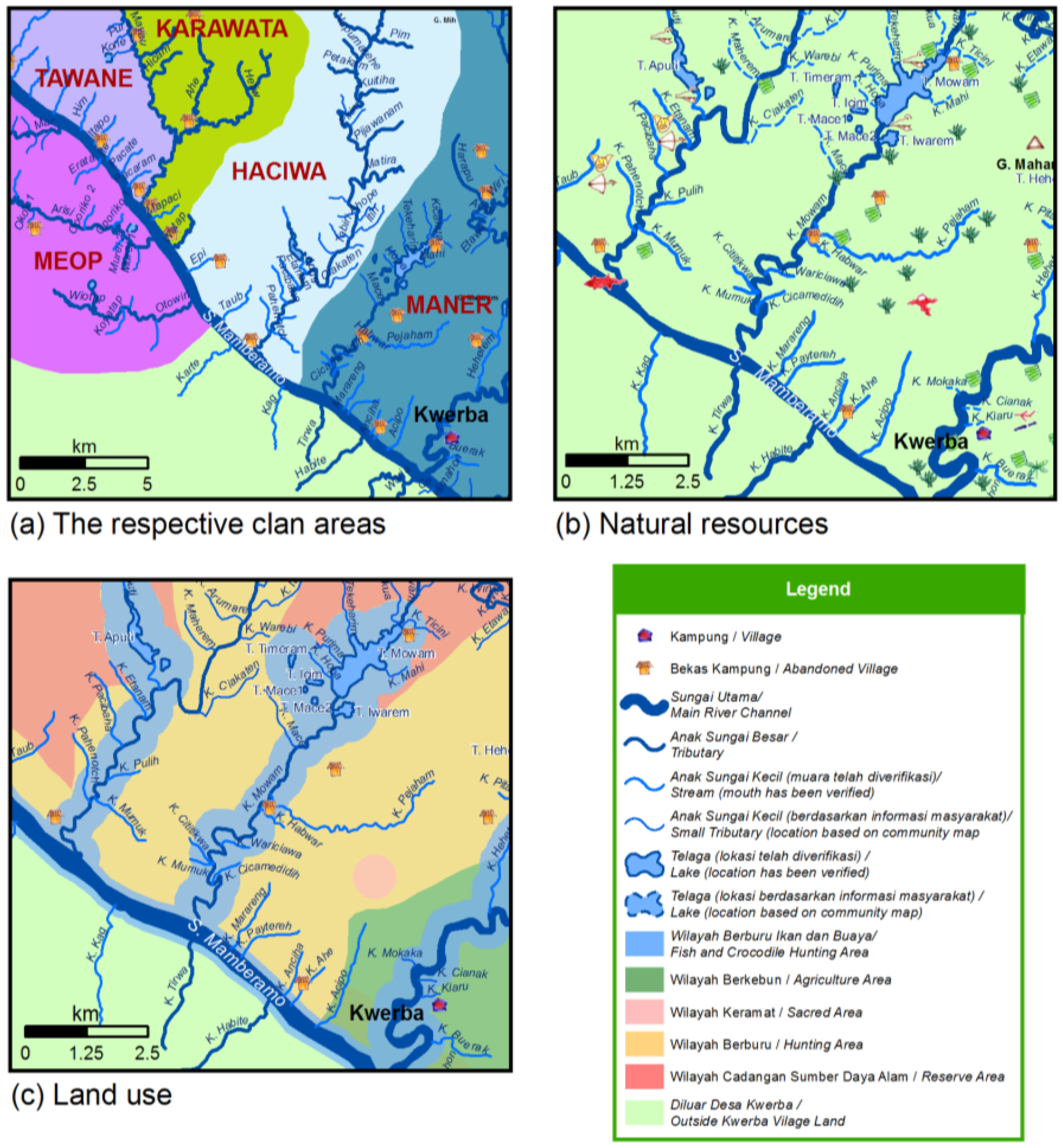
3.3.1. Mapping of Territories, Sites and Resources

- (1)
- Cultivation zone. Close to the principal settlement, in Maner territory near the Wiri River.
- (2)
- Hunting zones. Extensive forest areas located along each clan’s main tributary.
- (3)
- Reserved zones. Upstream of the tributaries, in primary forest.
- (4)
- Sacred areas. Scattered over the territory.
3.3.2. Area Protection
3.3.3. Protection or Restoration of Specific Resources
Crocodiles
Catfish
Birds of Paradise
Specific Plant Resources
4. Discussion
- People depended on natural resources for their livelihoods.
- For 12 of 14 use categories people found forests the most important land type.
- For food supply, however, people most valued their gardens, sago palms and the river.
- The most important species were Calophyllum sp., cassowary (Casuarius unappendiculatus), gnetum (Gnetum gnemon L.), crocodile (Crocodylus novaeguineae) and wild pig (Sus scrofa).
- People still respected customary leadership.
- Customary control systems and regulations for protecting sites and resources were operational and were updated when necessary.
- People recognized “reserved areas,” where activities were regulated, and “sacred areas,” where all access was restricted.
- People saw exploitation by outsiders as a threat, but wanted to benefit from development, without losing control over their lands, forest and resources.
5. Looking Ahead
6. Conclusions
Acknowledgments
Author Contributions
Conflicts of Interest
References
- Sayer, J.; Sunderland, T.; Ghazoul, J.; Pfund, J.L.; Sheil, D.; Meijaard, E.; Venter, M.; Boedhihartono, A.K.; Day, M.; Garcia, C.; et al. Ten principles for a landscape approach to reconciling agriculture, conservation, and other competing land uses. Proc. Natl. Acad. Sci. USA 2013, 110, 8349–8356. [Google Scholar] [CrossRef] [PubMed]
- Hutton, J.; Adams, W.M.; Murombedzi, J.C. Back to the barriers? Changing narratives in biodiversity conservation. Forum Dev. Stud. 2005, 32, 341–370. [Google Scholar] [CrossRef]
- McCarthy, D.P.; Donald, P.F.; Scharlemann, J.P.; Buchanan, G.M.; Balmford, A.; Green, J.M.H.; Bennun, L.A.; Burgess, N.D.; Fishpool, L.D.C.; Garnett, S.T.; et al. Financial costs of meeting global biodiversity conservation targets: Current spending and unmet needs. Science 2012, 338, 946–949. [Google Scholar] [CrossRef] [PubMed]
- Mittermeier, R.; Mittermeier, C.; Brooks, T.; Pilgrim, J.; Konstant, W.; da Fonseca, G.A.; Kormos, C. Wilderness and biodiversity conservation. Proc. Natl. Acad. Sci. USA 2003, 100, 10309–10313. [Google Scholar] [CrossRef] [PubMed]
- Redpath, S.M.; Young, J.; Evely, A.; Adams, W.M.; Sutherland, W.J.; Whitehouse, A.; Amar, A.; Lambert, R.A.; Linnell, J.D.C.; Watt, A.; et al. Understanding and managing conservation conflicts. Trends Ecol. Evol. 2013, 28, 100–109. [Google Scholar] [CrossRef] [PubMed]
- Sheil, D.; Meijaard, E.; Angelsen, A.; Sayer, J.; Vanclay, J.K. Sharing future conservation costs. Science 2013, 339, 270–271. [Google Scholar] [CrossRef] [PubMed]
- Chape, S.; Harrison, J.; Spalding, M.; Lysenko, I. Measuring the extent and effectiveness of protected areas as an indicator for meeting global biodiversity targets. Philos. Trans. R. Soc. Ser. B: Biol. Sci. 2005, 360, 443–455. [Google Scholar] [CrossRef] [PubMed]
- Brooks, T.M.; Wright, S.J.; Sheil, D. Evaluating the success of conservation actions in safeguarding tropical forest biodiversity. Conserv. Biol. 2009, 23, 1448–1457. [Google Scholar] [CrossRef] [PubMed]
- Baker, J.; Milner-Gulland, E.; Leader-Williams, N. Park gazettement and integrated conservation and development as factors in community conflict at Bwindi Impenetrable Forest, Uganda. Conserv. Biol. 2012, 26, 160–170. [Google Scholar] [CrossRef] [PubMed]
- Scholte, P.; Degroot, W. From debate to insight: Three models of immigration to protected areas. Conser. Biol. 2010, 24, 630–632. [Google Scholar] [CrossRef] [PubMed]
- Solomon, J.; Jacobson, S.K.; Wald, K.D.; Gavin, M. Estimating illegal resource use at a Ugandan park with the randomized response technique. Hum. Dimens. Wildl. 2007, 12, 75–88. [Google Scholar] [CrossRef]
- Agrawal, A.; Redford, K. Conservation and displacement: An overview. Conserv. Soc. 2009, 7, 1–10. [Google Scholar] [CrossRef]
- Sharpe, B. “First the forest”: Conservation, “community” and “participation” in south-west Cameroon. Africa 1998, 68, 25–45. [Google Scholar] [CrossRef]
- Boissière, M.; Sheil, D.; Basuki, I.; Wan, M.; Le, H. Can engaging local people’s interests reduce forest degradation in Central Vietnam? Biodivers. Conserv. 2009, 18, 2743–2757. [Google Scholar] [CrossRef]
- Ellis, E.C.; Ramankutty, N. Putting people in the map: Anthropogenic biomes of the world. Front. Ecol. Environ. 2008, 6, 439–447. [Google Scholar] [CrossRef]
- Gorenflo, L.J.; Romaine, S.; Mittermeier, R.A.; Walker-Painemilla, K. Co-occurrence of linguistic and biological diversity in biodiversity hotspots and high biodiversity wilderness areas. Proc. Natl. Acad. Sci. USA 2012, 109, 8032–8037. [Google Scholar] [CrossRef] [PubMed]
- Adams, W.M.; Hulme, D. If community conservation is the answer in Africa, what is the question? Oryx 2001, 35, 193–200. [Google Scholar] [CrossRef]
- Kaimowitz, D.; Sheil, D. Conserving what and for whom? Why conservation should help meet basic human needs in the tropics. Biotropica 2007, 39, 567–574. [Google Scholar] [CrossRef]
- Mcshane, T.O.; Hirsch, P.D.; Trung, T.C.; Songorwa, A.N.; Kinzig, A.; Monteferri, B.; Mutekanga, D.; Thang, H.V.; Dammert, J.L.; Pulgar-Vidal, M.; et al. Hard choices: Making trade-offs between biodiversity conservation and human well-being. Biol. Conserv. 2011, 144, 966–972. [Google Scholar] [CrossRef]
- Vermeulen, S.; Sheil, D. Partnership for tropical conservation. Oryx 2007, 41, 434–40. [Google Scholar] [CrossRef]
- Mavhunga, C. Even the rider and a horse are a partnership: A response to Vermeulen & Sheil. Oryx 2007, 41, 441–442. [Google Scholar]
- Robinson, J.G. Recognizing differences and establishing clear-eyed partnerships: A response to Vermeulen & Sheil. Oryx 2007, 41, 443–444. [Google Scholar]
- Sheil, D.; Boissière, M. Local people may be the best allies in conservation: Letter to the editor. Nature 2006, 440, 868–868. [Google Scholar] [CrossRef] [PubMed]
- Sheil, D.; Puri, R.K.; Basuki, I.; van Heist, M.; Wan, M.; Liswanti, N.; Rukmiyati; Sardjono, M.A.; Samsoedin, I. Exploring Biological Diversity, Environment and Local People’s Perspectives in Forest Landscapes, 2nd ed.; CIFOR: Bogor, Indonesia, 2003; Available online: http://www.cifor.org/mla/_ref/publications/detail/exploring_biological_diversity.htm (accessed on 2 September 2015)).
- Sheil, D.; Puri, R.K.; Wan, M.; Basuki, I.; van Heist, M.; Liswanti, N.; Rukmiyati; Rachmatika, I.; Samsoedin, I. Recognizing local people’s priorities for tropical forest biodiversity. Ambio 2006, 35, 17–24. [Google Scholar] [CrossRef] [PubMed]
- Bemei, Y.; Watopa, Y. Tantangan di bentang alam mamberamo raya. Trop. Indone. 2006, 10, 14–16. [Google Scholar]
- Boissière, M.; Liswanti, N.; Padmanaba, M.; Sheil, D. People Priorities and Perceptions. In Towards Conservation Partnership in Mamberamo; CIFOR: Bogor, Indonesia, 2007; Available online: http://www.cifor.org/mla/download/publication/People%20priorities.pdf (accessed on 2 September 2015).
- Supriatna, J.; Fretes, Y.; de Mack, A.; Yeager, C.P.; Olivieri, S.; Burnett, J.B.; Wijayanto, I.; Suryadi, S.; Suhandi, A. The Irian Jaya Biodiversity Conservation Priority-Setting Workshop (Final Report); Conservation International: Washington, DC, USA, 1999. [Google Scholar]
- Diamond, J.M. Rediscovery of the Yellowfronted Gardener Bowerbird. Science 1982, 216, 431–434. [Google Scholar] [CrossRef] [PubMed]
- Diamond, J.M. New distributional records and taxa from the outlying mountain ranges of New Guinea. Emu 1985, 85, 65–91. [Google Scholar] [CrossRef]
- Boissière, M.; van Heist, M.; Sheil, D.; Basuki, I.; Frazier, S.; Ginting, U.; Wan, M.; Hariadi, B.; Hariyadi, H.; Kristianto, H.D.; et al. Pentingnya sumberdaya alam bagi masyarakat lokal di daerah aliran Sungai Mamberamo, Papua, dan implikasinya bagi konservasi. J. Trop. Ethnobiol. 2006, 1, 76–95. [Google Scholar]
- Marshall, A.J.; Beehler, B.M. The Ecology of Papua, 1st ed.; Periplus Editions: Singapore, 2007. [Google Scholar]
- Richards, S.J.; Suryadi, S. A biodiversity assessment of Yongsu-Cyclops mountains and the southern Mamberamo basin, Papua, Indonesia. In RAP Bulletin of Biological Assessment, 25; Conservation International: Washington, DC, USA, 2002. [Google Scholar]
- Franky, Y.L.; Morgan, S. Papua Oil Palm Atlas: The Companies Behind the Plantation Explosion; Yayasan PUSAKA: Jakarta, Indonesia, 2015. [Google Scholar]
- Van Heist, M.; Sheil, D.; Rachman, I.; Gusbager, P.; Raweyai, C.; Yoteni, H. The forests and related vegetation of Kwerba, on the Foja Foothills, Mamberamo, Papua (Indonesian New Guinea). Blumea J. Plant Taxon. Plant Geogr. 2010, 55, 153–161. [Google Scholar] [CrossRef]
- Sheil, D.; Liswanti, N. Scoring the importance of tropical forest landscapes with local people: Patterns and insights. Environ. Manag. 2006, 38, 126–136. [Google Scholar] [CrossRef] [PubMed]
- Colfer, C.J.P.; Brocklesby, M.A.; Diaw, C.; Etuge, P.; Günter, M.; Harwell, E.; McDougall, C.; Porro, N.M.; Porro, R.; Prabhu, R.; et al. The Grab Bag: Supplementary Methods for Assessing Human Well-Being; The Criteria & Indicators Toolbox Series, Number 6; CIFOR: Bogor, Indonesia, 1999; Available online: http://www.cifor.org/livesinforests/publications/pdf_files/toolbox-6c.pdf (accessed on 2 September 2015).
- Maner, A.; (Kwerba, West Papua, Indonesia). Personal communication, 2004.
- Frazier, S. Crocodile Monitoring in Irian Jaya, Indonesia (Final Consultancy Report on FAO Project GCP/INS/060/JPN “Crocodile Industry Development on a Sustainable Basis”); Food and Agriculture Organization of the United Nations: Rome, Italy, 1989; Available online: http://agris.fao.org/aos/records/XF9091655 (accessed on 2 September 2015).
- Cox, J. Development of the Crocodile Industry on a Sustainable Basis (Terminal Report FAO-PHPA Project GCP/INS/060/JPN); Food and Agriculture Organization of the United Nations: Rome, Italy, 1992; Available online: http://agris.fao.org/aos/records/XF9661333 (accessed on 2 September 2015).
- Untung, B.; (Natural Resource Conservation Agency or BKSDA, Jayapura, West Papua, Indonesia). Personal communication, 2004.
- Sheil, D. Villagers: Villains or allies in forest biodiversity conservation? The IUCN/WWF Forest Conservation Newsletter. Arborvitae 2006, 30, 12. [Google Scholar]
- Sheil, D.; Wunder, S. The value of tropical forest to local communities: Complications, caveats and cautions. Conserv. Ecol. 2002, 6, 9. [Google Scholar]
- Redford, K.H.; Stearman, A.M. Forest-dwelling native Amazonians and the conservation of biodiversity. Conserv. Biol. 1993, 7, 248–255. [Google Scholar] [CrossRef]
- Lawrence, A.; Sheil, D. Tropical biologists, local people and conservation: New opportunities for collaboration. Trends Ecol. Evol. 2004, 19, 634–638. [Google Scholar]
- Gadgil, M.; Rao, P.R.S.; Utkarsh, G.; Pramod, P.; Ashwini Chhatre and Members of the People’s Biodiversity Initiative. New meaning for old knowledge: The people’s biodiversity registers program. Ecol. Appl. 2000, 10, 1307–1317. [Google Scholar] [CrossRef]
- Adams, M.; Aveling, R.; Brockington, D.; Dickson, B.; Elliot, J.; Hutton, J.; Roe, D.; Vira, B.; Wolmer, W. Biodiversity conservation and the eradication of poverty. Science 2004, 306, 1146–1149. [Google Scholar] [CrossRef] [PubMed]
- Berkes, F. Rethinking community-based conservation. Conserv. Biol. 2004, 18, 621–630. [Google Scholar] [CrossRef]
- Sheil, D.; Boissière, M.; Beaudoin, G. Unseen sentinels: Local monitoring and control in conservation’s blind-spots. Ecol. Soc. 2015, 20, 39. [Google Scholar] [CrossRef]
- Boissière, M.; Sassen, M.; Sheil, D.; van Heist, M.; de Jong, W.; Cunliffe, R.; Wan, M.; Padmanaba, M.; Liswnati, N.; Basuki, I.; et al. Researching local perspectives on biodiversity in tropical landscapes: Lessons from ten case studies. In Taking Stock of Nature: Participatory Biodiversity Assessment for Policy Planning and Practice, 1st ed.; Lawrence, A., Ed.; Cambridge University Press: Cambridge, UK, 2010; pp. 113–141. [Google Scholar]
- Garden. New Plants Found in Indonesian “Lost World” (News); Royal Horticultural Society: London, UK, 2006. [Google Scholar]
- Garden. Plant Discoveries: Palm Tree is A New Genus; Royal Horticultural Society: London, UK, 2006. [Google Scholar]
- Cyranoski, D. Calls to conserve biodiversity hotspots. Nature 2006, 439, 774. [Google Scholar] [CrossRef] [PubMed]
- Beehler, B.M.; Prawiradilaga, D.M.; de Fretes, Y.; Kemp, N. A new species of Smoky Honeyeater (Meliphagidae: Melipotes) from western New Guinea. Auk 2007, 124, 1000–1009. [Google Scholar] [CrossRef]
- Padmanaba, M.; Boissière, M.; Ermayanti, S.; Sumantri, H.; Achdiawan, R. Perspectives on Collaborative Land Use Planning in Mamberamo Raya Regency, Papua, Indonesia; Case studies from Burmeso, Kwerba, Metaweja, Papasena, and Yoke; Project Report; CIFOR: Bogor, Indonesia, 2012; Available online: http://www.cifor.org/mla/download/publication/Mamberamo_en_web.pdf (accessed on 2 September 2015).
- Somba, N.D. Mamberamo Raya strives to conserve forested lands. The Jakarta Post. Available online: http://www.thejakartapost.com/news/2012/05/29/mamberamo-raya-strives-conserve-forested-lands.html (accessed on 2 September 2015).
- Indopacific Conservation Alliance IPAC. Facilitating community-driven conservation and strengthening local cultural institutions in Asmat and the Greater Lorentz Lowlands, 2012. Available online: http://indopacific.org/asmat.asp (accessed on 2 September 2015).
- Agrawal, A.; Angelsen, A. Using community forest management to achieve REDD+ goals. In Realising REDD+. National Strategy and Policy Options; Angelsen, A., Ed.; CIFOR: Bogor, Indonesia, 2009. [Google Scholar]
- Ostrom, E.; Burger, J.; Field, C.B.; Norgaard, R.B.; Policansky, D. Revisiting the commons: Local lessons, global challenges. Science 1999, 284, 278–282. [Google Scholar] [CrossRef] [PubMed]
- Cole, D.; Ostrom, E. The Variety of Property Systems and Rights in Natural Resources; Environmental Affairs Research Paper No. 2010-08-01; Indiana University-Bloomington School of Public and Environmental Affairs: Bloomington, IN, USA, 2010. [Google Scholar]
- FAO. Tenure Security for Better Forestry. Understanding Forest Tenure in South and Southeast Asia; Food and Agriculture Organization of the United Nations: Rome, Italy, 2007. [Google Scholar]
- Porter-Bolland, L.; Ellis, E.A.; Guariguata, M.R.; Ruiz-Mallén, I.; Negrete-Yankelevich, S.; Reyes-García, V. Community managed forests and forest protected areas: An assessment of their conservation effectiveness across the tropics. For. Ecol. Manag. 2012, 268, 6–17. [Google Scholar] [CrossRef]
© 2015 by the authors; licensee MDPI, Basel, Switzerland. Licensee MDPI, Basel, Switzerland. This article is an open access article distributed under the terms and conditions of the Creative Commons Attribution (CC BY) license ( http://creativecommons.org/licenses/by/4.0/).
Share and Cite
Van Heist, M.; Liswanti, N.; Boissière, M.; Padmanaba, M.; Basuki, I.; Sheil, D. Exploring Local Perspectives for Conservation Planning: A Case Study from a Remote Forest Community in Indonesian Papua. Forests 2015, 6, 3278-3303. https://doi.org/10.3390/f6093278
Van Heist M, Liswanti N, Boissière M, Padmanaba M, Basuki I, Sheil D. Exploring Local Perspectives for Conservation Planning: A Case Study from a Remote Forest Community in Indonesian Papua. Forests. 2015; 6(9):3278-3303. https://doi.org/10.3390/f6093278
Chicago/Turabian StyleVan Heist, Miriam, Nining Liswanti, Manuel Boissière, Michael Padmanaba, Imam Basuki, and Douglas Sheil. 2015. "Exploring Local Perspectives for Conservation Planning: A Case Study from a Remote Forest Community in Indonesian Papua" Forests 6, no. 9: 3278-3303. https://doi.org/10.3390/f6093278