Article

Do Anthropogenic Dark Earths Occur in the Interior of Borneo? Some Initial Observations from East Kalimantan

1
Institute of Tropical Forest Conservation, P.O. Box 44, Kabale, Uganda
2
School of Environmental Science and Management, Southern Cross University, P.O. Box 157, Lismore, NSW 2480, Australia
3
Center for International Forestry Research (CIFOR), P.O. Box 0113 BOCBD, Bogor 16000, Indonesia
4
Department of Anthropology, University of Georgia, 255 Baldwin Hall, Athens, GA 30602, USA
5
Department of Soil Quality, Wageningen University, P.O. Box 47, Wageningen NL-6700 AA, The Netherlands
6
Fauna & Flora International—Indonesia Program, Komplek Laboratorium Pusat UNAS, JL. Harsono RM No 1 Ragunan, Jakarta Selatan 12550, Indonesia
7
Centre for BioCultural Diversity, School of Anthropology and Conservation, University of Kent at Canterbury, Kent CT2 7NR, UK
8
Centre Asie du Sud-Est (Centre National de la Recherche Scientifique and Ecole des Hautes Etudes en Sciences Sociales), Maison de l'Asie, 22, Avenue du Président Wilson, Paris 75016, France
9
World Agroforestry Centre, ICRAF Southeast Asia, Jalan CIFOR, Situgede, Sindangbarang, Bogor 16115, Indonesia
10
Gund Institute for Ecological Economics and Rubenstein School of Environment and Natural Resources, University of Vermont, 617 Main Street, Burlington, VT 05405, USA
*
Author to whom correspondence should be addressed.
Forests 2012, 3(2), 207-229; https://doi.org/10.3390/f3020207
Submission received: 16 February 2012 / Revised: 31 March 2012 / Accepted: 11 April 2012 / Published: 7 May 2012
(This article belongs to the Special Issue Long-Term Effects of Fire on Forest Soils)

Abstract

:
Anthropogenic soils of the Amazon Basin (Terra Preta, Terra Mulata) reveal that pre-Colombian peoples made lasting improvements in the agricultural potential of nutrient-poor soils. Some have argued that applying similar techniques could improve agriculture over much of the humid tropics, enhancing local livelihoods and food security, while also sequestering large quantities of carbon to mitigate climate change. Here, we present preliminary evidence for Anthropogenic Dark Earths (ADEs) in tropical Asia. Our surveys in East Kalimantan (Indonesian Borneo) identified several sites where soils possess an anthropogenic development and context similar in several respects to the Amazon’s ADEs. Similarities include riverside locations, presence of useful fruit trees, spatial extent as well as soil characteristics such as dark color, high carbon content (in some cases), high phosphorus levels, and improved apparent fertility in comparison to neighboring soils. Local people value these soils for cultivation but are unaware of their origins. We discuss these soils in the context of local history and land-use and identify numerous unknowns. Incomplete biomass burning appears key to these modified soils. More study is required to clarify soil transformations in Borneo and to determine under what circumstances such soil improvements might remain ongoing.

Graphical Abstract

1. Introduction

The anthropogenic soils of the Amazon Basin have generated considerable interest. These Hortic Anthrosols, also known as Terra Preta do Indio, contrast strongly with the surrounding soils (mostly Oxisols and Ultisols) in terms of higher and more stable soil organic matter, presence of charcoal, higher phosphorus (P), and superior moisture-holding capacity [1]. Patches of these Anthropogenic Dark Earths (ADEs) range in size from less than one to as large as 350 ha, but most are only a few hectares [2]. The majority of sites are 500 to 2,500 years old [3]. Present-day farmers value these soils for their high and sustained productivity and ability to grow crops that would otherwise require chemical fertilizers. Glaser [1] argued that understanding how to generate these soils may revolutionize agricultural production in the humid tropics. The soils also store up to 150 g kg−1 of carbon (C) [4] compared to the 20–30 g kg−1, stored in surrounding Oxisols, suggesting wider application may mitigate climate change [5,6,7]. The nature and origin of these soils has thus become a subject of interest.
The processes, activities and human intentions that contributed to these ADEs are still debated [8,9]. Their development likely involved positive feedbacks, where soil improvement supported local population growth which led to further soil use and development [10]. Evidence shows that Terra Preta was formed through the addition of char (incompletely combusted organic material under conditions of low O2 availability [11]) and nutrient inputs from village refuse and manure [12,13,14].
Rainforest soils are often low in the mineral nutrients required for agriculture. This is due to prolonged weathering and leaching on stable landforms and to the tendency for soil organic matter and associated nutrients to be quickly lost to decomposition following the clearing of vegetation [15]. Generally soil nutrient levels, and agricultural fertility, are highly correlated with levels of soil organic matter [16]. Most soil organic matter is short-lived (weeks to months). Soil clay and silt content are the primary correlates of soil C in the humid tropics, as they provide physical protection of organic compounds from microbial breakdown [17]. By contrast char is long-lived, and independent of soil texture, due to its recalcitrance to microbial decomposition. Typical half-lives are in the order of thousands of years [18]. Char contains large numbers of carboxylic and phenolic groups, which underlies the high cation exchange capacity (CEC) and nutrient retention capacity found in many anthropogenic soils [11,19]. Terra Preta has markedly higher levels of soil organic matter than the surrounding soils. Most is in the form of char.
Swidden farming, or the use of fire to convert vegetative biomass into nutrients, can result in either “slash-and-burn” (generating ash, rather than char, having ephemeral effects and leading to shifting cultivation with long fallows) or “slash-and-char” (generating char, having persistent effects and allowing the transformation towards permanent agriculture or short-term fallows) [20]. Slash-and-char produces more recalcitrant C. Other smoldering fires also produce char (such as cooking fires and fires to chase insects away). The resulting stable organic matter affects the soil’s nutrient and water-holding capacity, structure and pH buffering and provides a useful index of fertility [16].
Kämpf et al. [21] proposed criteria for the identification of Amazonian Dark Earths. These include a thickness of 20 cm or more overlying an Oxisol or Ultisol (this being evidence for accumulation of earth material); the presence of artifacts, shells and aquatic organisms or other cultural material; levels of elemental P ≥ 65 mg kg−1 (Mehlich-1, an assay method widely used in Brazil), charcoal ≥ 10 g kg−1 (in the top soil to 40 or 60 cm depth); a humic-to-fulvic acid (HA/FA) ratio larger than two; and clear spatial association with prior human activities. For cases where available P (Mehlich-1) do not reach 65 mg kg−1 due to recent crop production and depletion of that pool Kämpf et al. [21] suggest an additional criterion of 200 mg kg−1 of total soil P. Other features that tend to set ADEs apart from surrounding soils include higher total nitrogen (N) content (the high C:N ratio of these soils can nonetheless result in lower N availability than in surrounding soils), higher soil pH (associated with ash and inputs of shells and bones), higher CEC (associated with the high HA/FA ratio) and base saturation, coarser texture, and lower exchangeable aluminum (due to higher pH). In the Amazon, forested Terra Preta locations also support above average densities of fruit trees, palms and other useful plants [22]. High levels of P in ADEs are of interest given the low levels found in most lowland tropical soils and the constraint these pose to plant growth [23,24]. Phosphorus is usually the key nutrient limiting agricultural productivity in the lowland tropics [25]. Very high P levels are often an indicator of human settlement due to long-term additions of P rich organic material [26].
Aside from prolonged human presence, details of the processes that led to ADEs remain poorly understood. The processes leading to Terra Preta and the associated intensity of agriculture (e.g., long vs. short-fallow rotations, or permanent fields) are the subject of debate. Processing of soils by earthworms and other soil organisms is believed to play a role by helping to stabilize the organic matter from char [27,28,29]. Conventional thinking states that Terra Preta cannot result from long-fallow shifting cultivation after slash-and-burn, as most biomass is transformed to ash rather than longer-lived char, and relatively ephemeral nutrient increases.
The study of anthropogenic soils in the tropics has focused on the Amazon Basin. Soils similar to ADEs have been described elsewhere in the neotropics [30] as well as in southern and western Africa [31,32]. However, to date, comparable evaluations in tropical Asia are absent. This paper presents findings from an exploratory search for ADEs in Malinau District, Kalimantan (Indonesian Borneo) and places these in the context of what we know and can surmise about land-use history.
We use the rest of section 1 to summarize key aspects of land-use history in the interior of Borneo. In section 2 we present our results, discuss evidence for ADEs and evaluate the circumstances that could have led to their formation. In section 3 we provide a more detailed overview of the research site and our methods. We summarize our main conclusions in section 4.

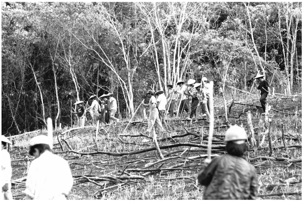
People and Cultivation in the Interior of Borneo

Modern humans have been present in Borneo for over 50,000 years [33] and in East Kalimantan for over 10,000 years [34,35,36]. The earliest evidence of rice consumption in Borneo dates to c. 4500 BP [37], though rice phytoliths dating before 7000 BP have been reported from Sarawak [33]. Regular clearing of significant areas of forests as a land-use system is unlikely to predate the advent of iron tools [38]. Suitable technologies likely reached Borneo’s coasts around 2000 BP but made slow and uneven progress into the interior [39,40]. While 19th century European explorers to Borneo’s interior predominantly found rice cultivators using iron tools, stone tools remained in use in some communities until the mid-20th century [41,42,43,44].
Pre-iron forest clearance would likely have focused on small scale cultivation of root and tuber crops [33,45,46]. Some modern groups still rely on a mix of rice and tubers [47,48]. Only among certain iron possessing groups was swidden rice cultivation extensively developed, contributing to these groups’ demographic, cultural and military prominence. These groups expanded their influence, conquering, assimilating, replacing and influencing others [46,49,50,51]. During the last millennium a number of these swidden rice farming groups (including Kenyah, Kayan and, in our field area, the Merap) expanded into the interior of northern East Borneo [52]. The resulting settlements included hundreds to thousands of inhabitants and were organized to defend their territories, especially the limited land suitable for cultivation [53].
All Malinau’s ethnic groups have been mobile—fleeing from wars, persecution and disease, or invading, or invited as part of new alliances [49,53,54,55]. Most Malinau communities (though not all of the Merap) say that they came from other watersheds within the last two centuries (various pers. comm. by community members to DS and IB). Other ethnic groups such as the Bulusu (or Berusu), were driven away [53]. Other evidence, such as the genetics of local rice cultivars, also indicates considerable migration and mixing in recent times [56].
Ethnographic accounts suggest that settlements in Malinau were traditionally located in strategic sites for protection against inter-tribal warfare and head-hunting raids [53] and leading to locations comparable to Denevan’s “bluff model” for pre-Colombian Amazonian settlements [57]. Villages relocated within their territory four or more times each century when there was a shortage of good farm land nearby. Catastrophes (floods, epidemics) and inter-tribal warfare, also led to frequent village relocation and to a relatively dynamic history of settlement in the region [53]. Ethno-historical accounts suggest that all contemporary communities have relocated their settlements many times in the last two centuries [58]. Since the early 20th century inter-tribal warfare ceased and communities have settled in accessible riverside locations [53].
Old village sites continue to be visited due to their high density of native fruit trees [59]. As the Malinau River possesses few riverside locations suited to settlement, most such sites were used at some point in the last half century (IB and DS unpublished interviews).
Swidden rice farming groups are not the only inhabitants. Much of the forested interior is unsuited to agriculture and remains the domain of sparsely distributed nomadic hunter-gatherers known as “Punan” [60]. The Punan often formed close associations with cultivators such as the Merap, who found the Punan useful as a means to exploit and guard resources in their territory [60]. While the Punan had been familiar with agriculture for centuries, and often encouraged fruit trees around their camps, few developed significant gardens until the last three decades when the government encouraged them to settle [47].

2. Results and Discussion

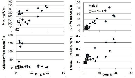
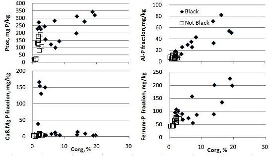
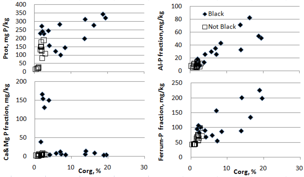
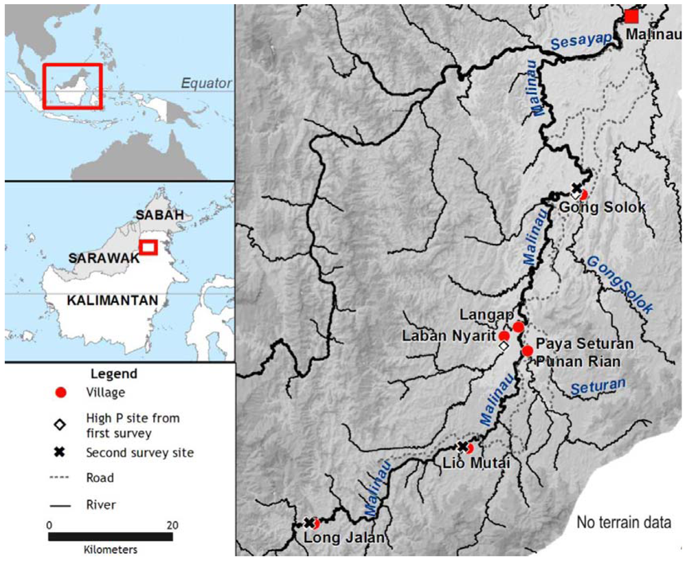
2.1. Results of the First Survey

Oxisols were found at 145 sites, Ultisols at 24, while Entisols, Alfisols and Inceptisols were observed at 13, 10 and 8 sites, respectively. We found no Andisols. Seventeen sites showed poor drainage and associated high levels of C (and are excluded when analyses refer to “dryland”). In the remaining 183 sites, soil nutrient levels were consistently very low, with low pH, limited CEC, low organic C, P, and base saturation. Soils showed marked acidity. Half of the forest locations had a pH-water lower than 4.4. Ratios of Calcium (Ca) to Aluminum (Al) (i.e., Ca2+/Al3+) were low, with median values of 0.15; 0.09; 0.23 for the Oxisols, Ultisols, and Inceptisols respectively, suggesting possible aluminum (Al) toxicity [61]. The best soils, in terms of nutrients required for plant growth, occurred on flood plain sites and in swampy areas. These soils were often visibly darker and richer in organic matter. Both Merap and Punan expressed a preference for these dark soils for agriculture compared to the more common red and yellow soils.
Local informants had a rich vocabulary and understanding of soil properties and agricultural potential. As might be expected from their contrasting agricultural and hunter-gatherer cultures, the Merap had a richer vocabulary and conceptual framework for describing soils than the Punan. The Merap used 20 terms to describe 79 plots, while the Punan used 14 terms to describe 84 plots (other plots were excluded as Kenyah and Putuk language terms were used, for a more detailed account of local soil terminology and criteria according to Malinau’s Merap and Punan people see [62]). All seven communities considered black or dark soils (tiem in Merap, punyuh in Punan) the best for agriculture, even though these soils were rare and localized. In our initial survey 43 out of 200 sites were identified by local residents as such “black soil(s)”. Of these, seven were on poorly drained sites.
Relative levels of soil C in the dryland sites were well predicted by soil texture (Pearson’s coefficient = 0.407, n = 183, p < 0.001) but were lower than expected (mean = 0.57% suggesting that topsoils in Malinau on average have lower soil C after correction for texture, than the soils in Sumatra where the equations were calibrated). There is no marked difference between forest and other land-use types, or between dark and non-dark soils (see Figure 1).
Black soils made up 36 of 183 (19%) of the dryland sites (Table 1). Black soil sites were commonly associated with human modified sites and comparatively scarce in old-growth forest sites (a null assumption that these frequencies are equal gives a χ2 = 4.72, p = 0.030). Among the old village sites nearly half were black soils (the likelihood that this is the same proportion as for forest sites, χ2 = 10.65, p = 0.0011).
Figure 1. Predicted versus measured percent carbon in the soil profile (0–20 cm depth) using the function developed in relatively similar conditions in Sumatra [17] based on soil texture and other factors applied to 183 well drained sites assessed in Malinau, Kalimantan (first survey). Symbols distinguish natural old-growth forest from other (human modified) sites, and those with black (i.e., dark soils) from the rest. The two sites with notably high P are individually marked.
Forests 03 00207 g001
Two soils possessed high P (Table 1). Both were from relatively flat riverside locations and both surpassed the criterion of ≥65 mg kg−1 elemental P for ADEs in the Amazon [21]. [Note that Kämpf et al. [21] used Mehlich-1 (a standard approach in Brazil), whereas we used Bray-1 (the standard approach in Indonesia where Mehlich-1 is not used) for P assessment. These methods give similar but not equivalent results. One study in an Amazonian oxisol suggests that Bray-1 can yield slightly higher estimates than Mehlich-1 [63]. Because both soils had much higher P-levels than mentioned by Kämpf et al. [21], we suggest they fit with the criterion of anthrosols]. One site in the territory of Gong Solok village (P concentration = 92.4 mg kg−1 at 0–20 cm) was under a fruit tree garden and recognized as “tana tiem” or “black soil” in Merap. The other old village site in the territory of Laban Nyarit village (P = 206.1 mg kg−1 at 0–20 cm), was also in a fruit garden and included both black and non-black soils, and was called “tano bulah” or “mixed soil” in Punan. The Laban Nyarit site possessed higher P-levels at 20–40 cm (418.7 mg kg−1), suggesting ancient P-enrichment, while the Gong Solok site has lower deep P and is likely less ancient (P = 59.8 mg kg−1 at 20–40 cm). Selecting seven other sites in similar riverside settings judged at roughly similar likelihood of flooding (at least 10 m but not more than 50 m from any river and all on level ground a few meters above river levels) revealed much lower levels of available P (mean 8.1 mg kg−1 at 0–20 cm), not different from the non-black soils. These localized black soils cannot be classified as Hortic Anthrosols as they lack the obvious hortic, irragric, plaggic or terric horizons required by the WRB soil classification system [64]. It remains striking, though, that farmers classify and value these black soils, even though our soil chemical analysis did not indicate any special properties.
Carbon levels and texture (clay and sand) of black soils were not significantly different from those of the other soils. The two sites with high P levels also did not show elevated levels of organic matter. Charred material was uncommon in the soil profiles. Char was seen in only 12 soil samples only four of which were black soils. The recognizable char observed in these profiles comprised small crumb-like grains and particles occasionally reaching 10 mm in diameter. These appeared to be charred wood. Some pieces were soft and brittle, while others were hard, and all shed black-dust. Char was observed in both fruit orchards with high P (Gong Solok and Laban Nyarit). All three primary forest sites that showed char were on hills near Long-Jalan—but none appeared to be black soils. Although char levels were not quantified, observations that neither C levels nor CEC were elevated in the two high P fruit orchard sites suggest only limited char deposition. Calcium levels were also not elevated in either site (Table 1).
Table 1. Median (and maximum) values for key soil parameters in Malinau.
ForestOld villageAgricultural Fallow
BlackOtherBlackOtherBlackOtherBlackOther
N =129298713834
Sand % (0–20 cm)3025.52940.5271511.525
Max4689697559454755
Clay % (0–20 cm)31.535.5252534303334
Max4865383442477954
pH H2O (0–20 cm) 4.24.44.94.85.44.85.14.5
Max6.05.26.25.75.95.86.05.6
C % (0–20 cm)1.61.91.61.61.52.22.21.9
Max3.06.92.02.82.63.43.54.3
C % (20–40 cm)0.91.00.70.90.81.11.10.9
Max3.14.61.32.41.22.92.51.6
*P mg kg−1 (0–20 cm)2.02.74.83.93.21.93.52.6
Max9.720.031.68.092.45.0206.126.8
*P mg kg−1 (20–40 cm)2.41.82.42.51.81.51.71.8
Max10.111.529.511.259.88.1418.85.1
Ca2+ mMole/100 g (0–20 cm)0.30.57.13.04.67.53.21.1
Max13.214.811.613.113.716.417.115.2
Ca2+mMole/100 g (20–40 cm)0.40.53.11.43.12.25.10.7
Max7.422.610.79.810.112.312.66.9
ECECmMole/100 g (0–20 cm)8.610.46.99.29.913.49.09.4
Max13.722.915.617.220.620.920.821.6
Base Saturation % (0–20 cm)9.514.083.069.077.078.048.524.0
Max100.0100.0100.0100.0100.0100.0100.096.0
* From Bray I procedure, but expressed as mg P kg−1 (see methods).

2.2. Results of the Second Survey

With guidance from local respondents we selected three additional well-drained black soil sites in three communities (Table 2). Distance from the Malinau River ranged from 200 to 300 m and the three sites were not considered at risk of regular flooding. Observations of the profiles, sample locations and the wider vicinity indicated that local soils were neither Histosols nor Andisols. Each was under dryland rice cultivation at the time of sampling. All three sites, including the surroundings, had been cleared and burned in the previous 4 to 6 months, but ash was no longer visible on the soil surface. The Gong Solok site had been used as a trial coffee garden in 1981 before being converted to rice. The Lio Mutai and Long Jalan sites (far upriver—in areas traditionally used by both Punan and Merap) had been cultivated as dryland rice swidden fields in the past, but a full history was unavailable. Local people indicated that no chemical fertilizer had been used on these sites. We compared five paired soil samples for each site (black versus non-black).
Table 2. Site description of black soil areas in each village.
Gong SolokLio MutaiLong Jalan
Ethnic groupMerapPunanPunan
Alt (m a.s.l.)85142252
Slope (%)84027
LandformFootslopeMid-slopeHilltop
Extent (soil)5 ha1 ha2 ha
Current land useSwidden (mainly * hill rice)Swidden (mainly hill rice)Swidden (mainly hill rice)
Recent land use historyCoffee and cocoa garden until 1981Swidden (mainly hill rice)Swidden (mainly hill rice)
SurroundingRice fields, RiverRice Field, Forest, Logging Trail, RiverForest, Village, River
* Areas generally include a number of other minor crops including maize, cassava, and green vegetables.
All three sites had somewhat elevated P levels (Table 3), although one site was below the 200 mg kg−1 P criterion [21]. The black soils at two sites had significantly higher C levels (nearly an order of magnitude more abundant) than the surrounding soils. Soil C:P ratios were around 500–600 for black soils and around 150–200 for the adjacent soils in two sites, suggesting that the increased C levels were due to inputs with very high C:P ratios (e.g., wood). On the other hand soil C:P ratios were 100 in black soils in the third site (Gong Solok) and around 200 for the adjacent soil (see Table 3) suggesting input of P-rich materials (possibly guano, and see discussion below). In that site a major part of the P was associated with the Ca-P fraction, rather than as iron (Fe) and Al (hydr-)oxides as in the two other sites (Figure 2).
Table 3. Percentage soil carbon and phosphorus from five replicates within and just outside three occurrences of fertile black soil, Mann-Whitney test statistic (Z) and one-sided p values.
SoilC (%)Total P HCl 25% extraction (mg kg−1)Total P after fractionation (mg kg−1)
BlackOtherBlackOtherBlackOther
Gong Solok, n =555555
Mean2.502.2424311424994
Median2.262.0424112426295
Z, p =−0.73, 0.548−2.61, 0.008−2.61, 0.008
Lio Mutai, n =555555
Mean7.880.901452213064
Median7.221.001452111763
Z, p =−2.61, 0.008−2.61, 0.008−2.61, 0.008
Long Jalan, n =555555
Mean15.101.96308159251101
Median16.311.92313150256100
Z, p=−2.61, 0.008−2.61, 0.008−2.61, 0.008
Figure 2. Relation between organic carbon (Corg, %) and total phosphorus, as well as three other P fractions (Fe-P, Al-P, Ca/Mg-P).
Forests 03 00207 g002

2.3. Evidence of Anthropogenic Dark Earths

Our first survey indicated that most soils were Oxisols with low levels of organic matter and plant nutrients. According to local classifications around 20% of our dryland sites possessed black/dark soils, most of which appeared unexceptional. Nonetheless two had distinctly elevated P levels (with unremarkable C levels). The second survey, which focused on three dark agriculturally productive sites, found that two possessed markedly higher P and C levels than surrounding soils.
Various characteristics of these four sites (two each from the first and second survey) are associated with ADEs: color, elevated levels of C and P, river-side locations, spatial extent, farmer-preferences and apparent extended human presence. Most strikingly, available soil P was substantially above the 65 mg kg−1 in the two sites from the first survey, and total soil P was about 200 mg kg−1 in the two sites from the second survey [21]. If these sites are anthropogenic should they also be considered as Terra Preta? We recognize several arguments against this:
Terra Preta soils possess significant charred organic matter. In our Borneo sites direct observations of char were limited—again, though this in itself is not conclusive, and further study is required [65].
Terra Preta sites are characterized by high HA:FA ratios and consequently high CEC. The two sites in our first survey did not have elevated CEC. Similarly Terra Preta sites have high levels of base cations and high base saturation. Again, this was not observed except in Gong Solok, with its high levels of calcium phosphates (Figure 2).
Terra Preta, like many Anthrosols [66], is characterized by high available (Mehlich-1, Bray-1) and total P, often in association with Ca, due to input from bones or guano. Two of our sites showed elevated available P (one also at depths below 20 cm, suggesting P enrichment took place a longer time ago), and two sites had total P consistent with the criterion of 200 mg kg−1. However, Kämpf et al. [21] used that criterion as a substitute only in cases where available P pool (was depleted by recent crop production. Sites in the second survey were only recently under intensive agriculture, so the application of that criterion (based on the consideration that P was only assessed that way) remains questionable. Classification of the black soils from the second survey as anthropogenic, though plausible, remains unproven.
Terra Preta soils are often associated with ceramics and other artifacts. Ceramics have not been found in our Malinau sites. This result is inconclusive due to the recognized differences in material cultures between regions. In contrast to Amazonia buried ceramics of any kind are, with specific exceptions, scarce precious imports in Malinau [67].
Sombroek (1966: 175) [68] proposed to subdivide the Amazonian Dark Earths into Terra Preta proper (black earth) and Terra Mulata (brown earth). Terra Mulata soils generally lack human artifacts and are of a lighter color. Others have expanded upon that distinction and suggested different origins for these soils—with Terra Preta being kitchen refuse “middens” and Terra Mulata being agricultural soils [69]. These distinctions remains somewhat theoretical as Amazonian Dark Earths reveal a continuum of intermediate forms [70]. Malinau’s soils cannot (yet) be accommodated in these schemes—more important for now are their origins.

2.4. Origins

Contemporary farmers seek out dark soils [62]. The fact that eight of 17 samples from abandoned villages assessed during our first survey were black soils also indicates some relationship with human settlements.
While sustained human presence and cultivation were previously considered as prerequisites for the generation of ADEs, evidence from southern Africa and temperate Australia indicates that even non-agricultural aboriginal peoples can create such soils [31,71]. We require an open minded examination of soil formation processes and outcomes.
We are not in a position to judge the degree to which our P rich Borneo soils are a result of simple agricultural practices or other aspects of human presence (e.g., depositional processes associated with middens) or both. The variation in soil chemical signatures suggests mixed histories of agricultural production and settlement, and a possible continuum between slash-and-burn and slash-and-char practices. For the agricultural sites, rather than an absolute contrast between the char and burn practices, we speculate that practices have resulted in partial burns that added both ash and char to soils (see the woody debris in Figure 3). Thus repeated burning of fallows generates darker soils with enhanced fertility and production. Such sites could contribute to more sedentary life styles. Soil heating, such as occurs with burning, can bring about other soil changes that remain incompletely understood [25,72]. In any case manure and other waste inputs would add P. Manure’s low N:P ratio allows accumulation of P. Such practices may have occurred in the past, as evidenced by the very high P levels in the 20–40 cm soil layer at one site in Laban Nyarit, and may still be occurring. An alternative and not necessarily exclusive hypothesis, particularly for sites high in both P and Ca, is that they result from human settlements.
Figure 3. Swidden farmers prepare a recently burned field cleared from secondary forest for planting with hill rice seed [73].
Forests 03 00207 g003
The occurrence of dark soils on steep slopes (the Lio Mutai and Long Jalan sites in our second survey) is notable. This is unlike anything reported from the Amazon region and may relate to the presence of hill-top settlements in the past—though this requires investigation. None of the soils in the first or second survey were Histosols or Andisols—this makes it less plausible that high P or organic matter might have a natural origin.
We do not believe natural factors explain Malinau’s P rich black soils. Similar to Terra Preta, natural explanations for such soils have been proposed that suggest that people preferentially settled at such sites rather than improved them (Katzer, 1903: 68) [74]. Carbon rich peat soils do not currently occur in the Malinau Valley. Peats are generally low in mineral nutrients, do not form or persist in well-drained locations, and they decompose (and burn) when subjected to drainage, cultivation and fire [75,76]. Swampy organic-carbon rich sites may have been drained by shifting river courses or the geological warping and up-thrust that have occurred across the region [77] but we would not expect such organic matter to persist in aerated and drained soils under cultivation. We also excluded sites with poor drainage from our evaluation of C-rich or P-rich soils. We therefore reject explanations that such soils are natural rather than human-made. For similar reasons we consider it unlikely that organic matter has been carried from poorly drained areas and applied to the fields: such material would have low persistence, would not explain the chemical attributes (P enrichment), and would require labor inputs we judge unlikely, especially given the lack of such practices in the region, though such practices in the past cannot be excluded.
Naturally occurring vegetation fires are unlikely to be localised to restricted riverside sites. We conclude that if burning has played a role in generating these soils it is predominantly human in origin. It is worth noting that, according to our data, land use has had little obvious impact on organic carbon (Corg) [78]. If farmers select sites with higher Corg this may somewhat balance any reduction caused by forest conversion but there is also a possibility that, as seen in anthropogenic soils elsewhere, such effects may not always be negative.
We can speculate on the factors leading to specific soils. Some sites with increased P-levels also had high C suggesting the addition of organic material. Wood addition would have resulted, at least initially, in a very high C:P ratio, and in two sites the black soils had a C:P ratio that was around three times as high as the adjacent soils. In contrast, the black soils at the third site (Gong Solok) had a C:P ratio that was lower than that of the adjacent soil, suggesting addition of P-rich material. Refuse from a settlement would be one possible explanation. There are caves in the wider area making guano another possibility that could also explain the high levels of Ca in this soil (Table 2). In the first survey, the high P-levels in two sites suggest other origins, as they were not accompanied by higher C or Ca levels.
High P can occur in locations possessing an underlying phosphate-rich geology, but none of our observations suggest such an origin. There are no active volcanoes in Borneo [79] and several of our sites are on raised ground. Work on repeated swidden cycles elsewhere in Kalimantan indicates that under some circumstances, P availability increases, presumably related to deep rooting of the fallow vegetation and increased storage in organic matter [25], but such increases are far less than in the two soils of the first survey. The likely explanation is that the P results directly from human activity.
Whatever the sources of nutrients, there are potentials for feedback loops. Farmers in Malinau select cultivation sites based on soil color, surrounding vegetation, and “soil stickiness” [62]. Soils that are favored and further cultivated may improve over time if conditions are right and char accumulates. Furthermore, once a site has been cleared for cultivation it is more likely to be cleared and cultivated again. Clearing of fallows requires less labor than the clearing of intact rain forest (likely even more critical prior to iron-tools) and working close to settlements was safer in the days of inter-villages warfare [80].

2.5. Who Generated These Soils?

Local people in Malinau, as in the Amazon, are unaware of how locally valued anthropogenic soils have formed. Though Borneo never suffered the catastrophic depopulation and cultural loss that occurred following European contact in the Americas, local continuity is lacking in Malinau. Large-scale population movements, limited archaeological information and changing land-use practices limit our ability to describe local cultural histories in any detail.
Modern evidence of former human presence is seen in the fruiting and other useful trees in both the Amazon and in Malinau [22,54]. In Malinau, groves of fruit trees are found associated with abandoned village and camp sites often on ridges or mountain saddles inland from the main rivers. These sites are estimated to be as old as 250 years, a result consistent with oral histories and genealogical data, though the age of the trees themselves have yet to be determined. There are also old trees in and around extant villages and regular forest camps used for hunting and gathering trips, which indicate an extended human presence of at least a century and perhaps longer [54]. In any case, we are confident that farming people, though not necessarily rice farmers, have lived in Malinau for several centuries [51].
Our headwater soil sites are especially interesting due to their hill-slope locations. The short history of Punan cultivation makes it very unlikely that they are responsible if cultivation is the cause. More likely would be peoples whose lifestyles are more clearly determined by warfare and localized cultivation. While most Punan now farm to some degree, until recent decades most lived as hunter-gatherers, also trading forest products for rice and other goods. The limited soil-centered vocabulary of the Punan when compared to the Merap reflects their relative inexperience with agriculture. Merap judgments of soil properties are substantially closer to laboratory based measurements than those of the Punan [62]. The historical role of the Merap or other such farming peoples in these sites requires further exploration.
Could these soils result from some other practices? We know that Punan have maintained extensive Imperata grasslands by regular burning elsewhere in the region [54] but such practices seem unlikely to have contributed to localized P rich riverside black soils where such grasslands are absent. The ovens associated with Dark Earths in Australia resulted in a specific pattern of localized mounds and soil changes [71] that seem inapplicable in the Malinau context. Some combination of land preparation, cultivation, and waste disposal, whether intended or inadvertent, seems the most likely explanation for the Dark Earths in our Malinau sites.
Are Malinau’s dark anthropogenic soils relics as in the Amazon or are they still being created? Given how villagers clear, burn and char woody vegetation while preparing their gardens, and live nearby for years at a time, soil improvement and enrichment may be ongoing. Soils may be in various stages of transformation.

3. Experimental Section

3.1. Site and Land-Use Practices

Research was carried out within the Malinau River catchment in Malinau District, East Kalimantan, Indonesia (Figure 4). This region possesses rugged terrain, few roads and is judged to have low potential for agricultural intensification [62]. The region escaped the droughts and forest fires of 1997–1998 [81,82] and there are no reports, recent or historical, of large forest fires [83]. The area maintains dense rich rain forest, with small areas of human cultivation and fallows. Soils are diverse but no deep peats occur [62].
Population densities in the upper Malinau are less than one person per square kilometer [55,84]. Local people use land for a combination of shifting cultivation, gardening, permanent fruit orchards, hunting, fishing and the collection and trade of forest products [62,85,86]. Upland rice is now the predominant staple [54,62]. Modern-day settlements are all next to moderately sediment-rich rivers and most permanent cultivation of gardens and fruit orchards (agroforests) occurs on the restricted areas of relatively level riverside land even though these locations are often vulnerable to floods that occur every few years [86,87]. Swidden rice fields are found along the river’s edge as well as on steeper slopes inland, often alongside smaller streams and tributaries. Many farmers cultivate larger areas on the better soils near the river and smaller “insurance areas” away from the river that are less vulnerable to flood damage [62].
Figure 4. Location of Borneo (top left) and study region in Borneo (mid-left) and the study area with the six focal villages and soil locations (main figure).
Forests 03 00207 g004
When clearing fields, local farmers generally cut and gather smaller woody debris into piles before burning. These piles tend to be haphazard, though often placed around the base of larger trees and stumps or on the lower slopes of hillsides. Larger material is left where it falls. As there is no pronounced dry season, people burn as soon as the material is flammable due to worries that heavy rains may otherwise intervene. Burning is often incomplete. Sometimes unburned material is gathered into piles and burned a second time—even so pieces of charred green wood and roots, and charcoal survive (IB and DS unpublished observations and interview data). Woody roots in the soil profile are especially likely to char [72]. Rice planting involves making holes using pointed sticks. Rice is sowed into the holes which are then filled with loose surface material including ash and charcoal (Figure 4 [88]).

3.2. Surveys

We conducted two surveys. The first explored the variation in soils, and people’s perceptions of them, with seven different communities across the upper half of the catchment of the Malinau River—an area of around 2,200 km2. We did not explicitly seek dark or anthropogenic soils. The second survey focused on three selected sites with locally valued dark soils. In both surveys burned and charred material on the soil surface (generally crumbling fragments of blackened wood) was avoided during the sampling.

3.2.1. First Survey

In seven indigenous communities we sampled two hundred sites covering a wide range of conditions (guided by a participatory mapping exercise). Sites covered all major land types recognized by the communities as well as sites of special value. “Forests” (old growth natural stands) were differentiated from “fallows” based on local informants (typically the younger vegetation in fallows was obvious), while “agriculture” referred to plots currently under cultivation. We interviewed local informants about each site, including site history and past and potential land-use. We also asked them to identify and describe the soil based on a soil profile. During the digging and describing of the soil profiles notes were made of visible particles of charcoal. Three communities were predominantly Punan (Long Jalan, Lio Mutai, and Punan Rian), three were predominantly Merap (Langap, Gong Solok, and Paya Seturan) and one was mixed (Laban Nyarit). The methods [89] and various results from these surveys have been published elsewhere [55,59,63,84].
In each location soil samples of 0–20 cm depth were augured from three sites 10 m apart, mixed and sieved. Samples were oven dried at 105 °C for 24 hours and analyzed following standard procedures. Measurements included texture (pipette procedure; Sudjadi et al. 1971 in [90]), pH (KCl potassium chloride and H2O procedures; ISRIC 1993 in [90]), Corg (Black 1965 in [89]), available P (Bray I; expressed as elemental P mg kg−1; Bray and Kurtz 1945 in [90] n.b. this is the standard measure used in Indonesia and at that time we had no reason to consider the Mehlich-1 based criteria used in Brazil), CEC, exchangeable bases, base saturation, and Al (NH4OAc procedure; ISRIC 1993 in [90]). Soil order classification followed standard USDA soil taxonomy [91,92].

3.2.2. Second Survey

Local people identified especially fertile dark soils near each of three communities. Each site lies within 200 m of soil sampling sites from the first survey. At each site we took five paired samples (20 m apart) from these dark soils and adjacent soils (10 m from the boundary transition) at 0–20 cm depth. These samples were processed as before and analyzed for percentage of C and P. Total P was assessed by two methods: by extraction in 25%-HCl [90], and as the sum of P pools through P fractionation [93,94].
No carbon dating has yet been attempted on soils from either survey.
Statistical analyses were performed in MS-Excel and SPSS. For comparative purposes soil C was related to soil properties based on a regression developed for Sumatra. For each location soil C content was normalized for effects of texture, elevation and pH based on a pedotransfer equation:
Cref = (Depth/7.5)−0.527 × e(1.333 + 0.00994 × Clay% + 0.00699 * Silt% − 0.156 × pH_KCl + 0.000427 × Elevation) (1)
here Cref is the Corg expected for a forest soil of the same texture, pH and elevation; e is the base of natural logarithms, while Depth, Clay%, Silt%, pH_KCl refer to depth measured in cm, clay and silt as gravimetric percentage of soil composition; and pH_KCl is the pH of a 1 N KCl extraction solution; Elevation is meters (m) altitude above sea level, see [17].

4. Conclusions

We have found sites in Borneo which exhibit some of the defining features of the Anthropogenic Dark Earths of tropical South America. The sites show distinguishing color and chemical signatures in terms of higher P or C levels compared to surrounding soils, fertility (as testified by local farmers), location, extent (1–5 ha) and cultural contexts. Human activity appears to be the only plausible explanation, yet we are uncertain about the age of the soils, who created them, by what processes and in what historical period(s). Farmers recognize the dark soils and favor them for both annual and perennial crops, yet they do not know what led to their formation. We suggest that the soils formed through incomplete combustion during repeated swidden cultivation and the inadvertent nutrient enrichment associated with human presence and domestic animals, resulting in the generation and accumulation of incompletely burnt biomass (char) in the soil. An alternative hypothesis, particularly for sites high in both P and Ca, is that they are due to depositional processes related to human settlement. Irrespective of the initial process, localized positive feedback cycles probably occurred in the selection of favorable sites and their further modification (cultivation and/or deposition). We underline that these soils may be young and their cultivation properties may not be durable. It is valuable to recognize the localized improvements of soil properties that can take place in specific contexts, but this does not suggest that Borneo’s soils are generally suitable for agricultural intensification or large-scale expansion of agriculture. Further research is required to clarify the origins of these soils in Malinau and whether similar soils can be found elsewhere in Borneo and the Asian tropics.
Our observations have raised many exciting opportunities for further investigation. Further study on the distribution, dating, chemistry, structure, persistence and source of soil C and soil nutrients, and on local and regional palynology, archaeology and cultural and land-use history, would support more conclusive findings. The effects of pyrogenic versus other soil constituents on soil nutrients, stability and fertility should be explored. Examination of the soils, crops and local knowledge associated with different settlement histories and land-use practices elsewhere in Borneo and the wider region may shed further light on these processes and relationships.

Acknowledgments

The original survey was conducted under a project grant to CIFOR “Bulungan Model Forest Project, (PD12/97 Rev.1[F]) funded by the International Tropical Timber Organization (ITTO), the second survey was supported by funds from the European Commission. We thank Agus Salim for help preparing the map and the reviewers and editors for their comments, clarifications and corrections. DS, IB and RP designed the first survey which was undertaken by DS and IB, the second survey was designed by DS, IB and LG and undertaken by IB. Analysis and paper preparation was led by DS and IB with input from all authors.

Conflict of Interest

The authors declare no conflict of interest.

References and Notes

  1. Glaser, B. Prehistorically modified soils of central Amazonia: A model for sustainable agriculture in the twenty-first century. Philos. T. R. Soc. Lon. B 2007, 362(1478), 187–196. [Google Scholar] [CrossRef]
  2. Novotny, E.H.; Hayes, M.H.B.; Madari, B.E.; Bonagamba, T.J.; deAzevedo, E.R.; de Souza, A.A.; Song, G.X.; Nogueira, C.M.; Mangrich, A.S. Lessons from the Terra Preta de Indios of the Amazon region for the utilisation of charcoal for soil amendment. J. Brazil. Chem. Soc. 2009, 20(6), 1003–1010. [Google Scholar]
  3. Rebellato, L.; Woods, W.I.; Neves, E.G. Pre-columbian settlement dynamics in the central Amazon. In Amazonian Dark Earths: Wim Sombroek’s Vision; Woods, W.I., Teixeira, W.G., Lehmann, J., Steiner, C., Prins, A.W., Rebellato, L., Eds.; Springer: Dordrecht, The Netherlands, 2009; pp. 15–31. [Google Scholar]
  4. Glaser, B.; Haumaier, L.; Guggenberger, G.; Zech, W. The ‘Terra Preta’ phenomenon: A model for sustainable agriculture in the humid tropics. Naturwissenschaften 2001, 88(1), 37–41. [Google Scholar] [CrossRef]
  5. Batjes, N.H. Mitigation of atmospheric CO2 concentrations by increased carbon sequestration in the soil. Biol. Fert. Soils 1998, 27(3), 230–235. [Google Scholar] [CrossRef]
  6. Fowles, M. Black carbon sequestration as an alternative to bioenergy. Biomass Bioenerg. 2007, 31(6), 426–432. [Google Scholar] [CrossRef]
  7. Lal, R. Global potential of soil carbon sequestration to mitigate the greenhouse effect. CRC Crit. Rev. Plant Sci. 2003, 22(2), 151–184. [Google Scholar] [CrossRef]
  8. Denevan, W.M. Semi-intensive pre-European cultivation and the origins of anthropogenic dark earths in Amazonia. In Amazonian Dark Earths: Explorations in Space and Time; Glaser, B., Woods, W., Eds.; Springer-Verlag: Berlin, Germany, 2004; pp. 135–144. [Google Scholar]
  9. German, L.A. Historical contingencies in the coevolution of environment and livelihood: Contributions to the debate on Amazonian Black Earth. Geoderma 2003, 111(3–4), 307–331. [Google Scholar] [CrossRef]
  10. Van Hofwegen, G.; Kuyper, T.W.; Hoffland, E.; van den Broek, J.A.; Beck, G.A. Opening the black box: Deciphering carbon and nutrient flows in Terra Preta. In Amazonian Dark Earths: Wim Sombroek’s Vision; Woods, W.I., Teixeira, W.G., Lehmann, J., Steiner, C., Prins, A.M.G.A.W., Rebellato, L., Eds.; Springer: Dordrecht, The Netherlands, 2009; pp. 393–409. [Google Scholar]
  11. Sohi, S.P.; Krull, E.; Elisa, L.C.; Bol, R. A review of biochar and its use and function in soil. Adv. Agron. 2010, 105, 47–82. [Google Scholar]
  12. German, L.A. Ecological praxis and blackwater ecosystems: A case study from the Brazilian Amazon. Hum. Ecol. 2004, 32(6), 653–683. [Google Scholar] [CrossRef]
  13. Lehmann, J.; Kern, D.C.; Glaser, B.; Woods, W. Amazonia Dark Earths: Origin, Properties, Management; Kluwer Academic Publishers: Dordecht, The Netherlands, 2003. [Google Scholar]
  14. Lima, H.N.; Schaefer, C.E.R.; Mello, J.W.V.; Gilkes, R.J.; Ker, J.C. Pedogenesis and pre-Colombian land use of “Terra Preta Anthrosols” (“Indian black earth”) of Western Amazonia. Geoderma 2002, 110(1–2), 1–17. [Google Scholar] [CrossRef]
  15. Tiessen, H.; Cuevas, E.; Chacon, P. The role of soil organic-matter in sustaining soil fertility. Nature 1994, 371(6500), 783–785. [Google Scholar] [CrossRef]
  16. Zech, W.; Senesi, N.; Guggenberger, G.; Kaiser, K.; Lehmann, J.; Miano, T.M.; Miltner, A.; Schroth, G. Factors controlling humification and mineralization of soil organic matter in the tropics. Geoderma 1997, 79(1–4), 117–161. [Google Scholar] [CrossRef]
  17. Van Noordwijk, M.; Woomer, P.; Cerri, C.; Bernoux, M.; Nugroho, K. Soil carbon in the humid tropical forest zone. Geoderma 1997, 79, 187–225. [Google Scholar]
  18. Cheng, C.H.; Lehmann, J.; Thies, J.E.; Burton, S.D. Stability of black carbon in soils across a climatic gradient. J. Geophys. Res. 2008, 113(G02027). [Google Scholar]
  19. Cunha, T.J.F.; Madari, B.E.; Canellas, L.P.; Ribeiro, L.P.; Benites, V.D.; Santos, G.D. Soil organic matter and fertility of anthropogenic dark earths (Terra Preta de Indio) in the Brazilian Amazon basin. Rev. Bras. Cienc. Solo 2009, 33(1), 85–93. [Google Scholar] [CrossRef]
  20. Steiner, C. Slash and Char as Alternative to Slash and Burn—Soil Charcoal Amendments Maintain Soil Fertility and Establish a Carbon Sink; Cuvillier Verlag: Göttingen, Germany, 2007. [Google Scholar]
  21. Kämpf, N.; Woods, W.I.; Sombroek, W.; Kern, D.C.; Cunha, T.J.F. Classification of Amazonian Dark Earths and other ancient anthropic soils. In Amazonian Dark Earths: Origin, Properties, Management; Lehman, J., Kern, D.C., Glaser, B., Woods, W.I., Eds.; Kluwer: Dordrecht, The Netherlands, 2003; pp. 105–124. [Google Scholar]
  22. Clement, C.R.; McCann, J.M.; Smith, N.J.H. Agrobiodiversity in Amazonia and its relationship with dark earths. In Amazonian Dark Earths: Origin, Properties and Management; Lehmann, J., Kern, D.C., Glaser, B., Woods, W.I., Eds.; Kluwer: Dordrecht, The Netherlands, 2003; pp. 159–178. [Google Scholar]
  23. Cleveland, C.C.; Townsend, A.R.; Schmidt, S.K. Phosphorus limitation of microbial processes in moist tropical forests: Evidence from short-term laboratory incubations and field studies. Ecosystems 2002, 5(7), 680–691. [Google Scholar]
  24. McGroddy, M.E.; Silver, W.L.; de Oliveira, R.C. The effect of phosphorus availability on decomposition dynamics in a seasonal lowland Amazonian forest. Ecosystems 2004, 7, 172–179. [Google Scholar]
  25. Lawrence, D.; Schlesinger, W.H. Changes in soil phosphorus during 200 years of shifting cultivation in Indonesia. Ecology 2001, 82(10), 2769–2780. [Google Scholar] [CrossRef]
  26. Eidt, R.C. Detection and examination of anthrosols by phosphate analysis. Science 1977, 197(4311), 1327–1333. [Google Scholar]
  27. Topoliantz, S.; Ponge, J.F.; Lavelle, P. Humus components and biogenic structures under tropical slash-and burn agriculture. Eur. J. Soil Sci. 2006, 57(2), 548–557. [Google Scholar]
  28. Ponge, J.-F.; Topoliantz, S.; Ballof, S.; Rossi, J.P.; Lavelle, P.; Betsch, J.M.; Gaucher, P. Ingestion of charcoal by the Amazonian earthworm Pontoscolex corethrurus: A potential for tropical soil fertility. Soil Biol. Biochem. 2006, 38(7), 2008–2009. [Google Scholar] [CrossRef]
  29. Joseph, S.D.; Arbestain, M.C.; Lin, Y.; Munroe, P.; Chia, C.H.; Hook, J.; van Zwieten, L.; Kimber, S.; Cowie, A.; Singh, B.P.; et al. An investigation into the reactions of biochar in soil. Aust. J. Soil Res. 2010, 48, 501–515. [Google Scholar] [CrossRef]
  30. Graham, E. A Neotropical framework for Terra Preta. In Time and Complexity in Historical Ecology—Studies in the Neotropical Lowlands; Balee, W., Erickson, C.L., Eds.; Columbia University Press: New York, NY, USA, 2006; pp. 57–86. [Google Scholar]
  31. Blackmore, A.C.; Mentis, M.T.; Scholes, R.J. The origin and extent of nutrient-enriched patches within a nutrient-poor savannah in South Africa. J. Biogeogr. 1990, 17, 463–470. [Google Scholar]
  32. Fairhead, J.; Leach, M. Amazonian Dark Earths in Africa? In Amazonian Dark Earths: Wim Sombroek’s Vision; Woods, W.I., Teixeira, W.G., Lehmann, J., Steiner, C., WinklerPrins, A.M.G.A., Rebellato, L., Eds.; Springer: Dordrecht, The Netherlands, 2009; pp. 265–278. [Google Scholar]
  33. Barker, G. Rainforest Foraging and Farming in Island Southeast Asia: The Archaeology of the Niah Caves, Sarawak; Sarawak Museum: Kuching, Malaysia, 2011. [Google Scholar]
  34. Chazine, J.-M. Rock Art, Burials, and Habitations: Caves in East Kalimantan. Asian Perspectives 2005, 44(1), 219–230. [Google Scholar] [CrossRef]
  35. Chazine, J.-M.; Ferrié, J.-G. Recent archaeological discoveries in East Kalimantan, Indonesia. Bull. Indo. Pac. Pre. Hi. 2008, 28, 16–22. [Google Scholar]
  36. McDonagh, S. Art on the rocks: Dating ancient paintings in the caves of Borneo. Science 2003, 164(10), 147. [Google Scholar]
  37. Datan, I. Archaeological Excavations at Gua Sireh (Serian) and Lubang Angin (Gunung Mulu National Park), Sarawak, Malaysia; Sarawak Museum: Sarawak, Malaysia, 1993; The Sarawak Museum Journal. Special monograph no. 6. [Google Scholar]
  38. Hutterer, K. The natural and cultural history of southeast Asian agriculture: Ecological and evolutionary considerations. Anthropos 1983, 78, 169–212. [Google Scholar]
  39. Avé, J.B.; King, V.T. Borneo: The People of the Weeping Forest; Tradition and Change in Borneo; National Museum of Ethnology: Leiden, The Netherlands, 1986. [Google Scholar]
  40. Dove, M. The transition from stone to steel in the prehistoric Swidden agricultural technology of the Kantu’ of Kalimantan, Indonesia. In Foraging and Farming. The Evolution of Plant Exploitation; Harris, D.R., Hillman, G.C., Eds.; Unwin Hyman: London, UK, 1989; pp. 667–677. [Google Scholar]
  41. Nicolaisen, J. The Penan of the seventh division of Sarawak: Past, present and future. Sarawak Mus. J. 1976, 24(45), 35–62. [Google Scholar]
  42. Nicolaisen, J. The Penan of Sarawak—Further Notes on the Neo-Evolutionary Concept of Hunters. Folk 1976, 18, 205–236. [Google Scholar]
  43. Harrisson, T.H. The prehistory of Borneo. In Prehistoric Indonesia; Velde, P.V.D., Ed.; Foris: Dordrecht, The Netherlands, 1984; pp. 297–326. [Google Scholar]
  44. Sellato, B. Nomads of the Borneo Rainforest. The Economics, Politics, and Ideology of Settling Down; University of Hawai’i Press: Honolulu, HI, USA, 1994. [Google Scholar]
  45. Boomgaard, P. In the shadow of rice. Roots and tubers in Indonesian history, 1500-1950. Agr. Hist. 2003, 77(4), 582–610. [Google Scholar]
  46. Barton, H. The reversed fortunes of sago and rice, Oryza sativa, in the rainforests of Sarawak, Borneo. Quatren. Int. 2012, 249, 96–104. [Google Scholar] [CrossRef]
  47. Sellato, B. Myth, history, and modern cultural identity among hunter-gatherers: A Borneo case. J. Southe. Asian Stud. 1993, 24(1), 18–43. [Google Scholar] [CrossRef]
  48. Sellato, B. Agricultural practices, social organization, settlement patterns, and ethnogenetic processes in East Kalimantan. In People and Plants of Kayan Mentarang; Sørensen, K.W., Morris, B., Eds.; World Wide Fund for Nature & UNESCO: London, UK, 1997; pp. 27–57. [Google Scholar]
  49. Okushima, M. Ethnohistory of the Kayanic peoples in Northeast Borneo. Borneo Res. Bull. 2006, 37, 86–126. [Google Scholar]
  50. Rousseau, J. Central Borneo: Ethnic Identity and Social Life in a Stratified Society; Clarendon Press: Oxford, UK, 1990. [Google Scholar]
  51. Sellato, B. The Punan question and the reconstruction of Borneo’s cultural history. In Change and Development in Borneo; Borneo Research Council: Williamsburg, VA, USA, 1993; pp. 47–81. [Google Scholar]
  52. Currie, T.E.; Greenhill, S.J.; Gray, R.D.; Hasegawa, T.; Mace, R. Rise and fall of political complexity in island South-East Asia and the Pacific. Nature 2010, 467, 801–804. [Google Scholar]
  53. Sellato, B. Forest, Resources and People in Bulungan: Elements for a History of Settlement, Trade, and Social Dynamics in Borneo, 1880–2000; Center For International Forest Research: Bogor, Indonesia, 2001. [Google Scholar]
  54. Puri, R.K. Post-abandonment ecology of Penan fruit Camps: Anthropological and ethnobiological approaches to the history of a rain-forested valley in East Kalimantan. In Conserving Nature in Culture: Case Studies from Southeast Asia; Dove, M.R., Sajise, P.E., Doolittle, A., Eds.; Yale University Council on Southeast Asia Studies: New Haven, CT, USA, 2005; pp. 25–82, Yale Southeast Asia Studies Monograph Series. [Google Scholar]
  55. Sheil, D. Biodiversity research in Malinau. In Technical Report Phase 1, 1997–2001. ITTO Project PD 12/97 Rev.1 (F): Forest, Science and Sustainability: The Bulungan Model Forest; 2002; pp. 57–107. CIFOR (Center for International Forestry Research): Bogor, Indonesia; ITTO (International Tropical Timber Organization): Yokohama, Japan, Chapter 5. [Google Scholar]
  56. Thomson, M.J.; Polato, N.R.; Prasetiyono, J.; Trijatmiko, K.R.; Silitonga, T.S.; McCouch, S.R. Genetic diversity of isolated populations of Indonesian landraces of rice (Oryza sativa L.) collected in east Kalimantan on the island of Borneo. Rice 2009, 2(1), 80–92. [Google Scholar] [CrossRef]
  57. Denevan, W.M. A bluff model of riverine settlements in prehistoric Amazonia. Ann. Assoc. Am. Geogr. 1996, 86, 654–681. [Google Scholar]
  58. Eghenter, C.; Sellato, B.; Devung, G.S. Social Science Research and Conservation Management in the Interior of Borneo: Unravelling Past and Present Interactions of People and Forests; CIFOR: Bogor, Indonesia, 2003. [Google Scholar]
  59. Sheil, D.; Liswanti, N. Scoring the importance of tropical forest landscapes with local people: Patterns and insights. Environ. Manage. 2006, 38(1), 126–136. [Google Scholar] [CrossRef]
  60. Sellato, B. Forests for food, forests for trade—between sustainability and extractivism—The economic pragmatism of traditional peoples and the trade history of northern East Kalimantan. In Histories of the Borneo Environment: Economic, Political and Social Dimensions of Change and Continuity; Wadley, R.L., Ed.; KITLV Press: Leiden, The Netherlands, 2005; pp. 61–86. [Google Scholar]
  61. Wilkinson, S.R.; Grunes, D.L.; Sumner, M. E Nutrient interaction in soil and plant nutrition. In Handbook of Soil Science; Sumner, M.E., Ed.; CRC Press: Boca Raton, FL, USA, 2000; pp. 89–112. [Google Scholar]
  62. Basuki, I.; Sheil, D. Local Perspectives of Forest Landscapes: A Preliminary Evaluation of Land and Soils, and Their Importance in Malinau, East Kalimantan, Indonesia; CIFOR: Bogor, Indonesia, 2005. [Google Scholar]
  63. Smyth, T.J.; Cravo, M.S. Critical phosphorus levels for corn and cowpea in a Brazilian oxisol. Agron. J. 1990, 82, 309–312. [Google Scholar]
  64. IUSS-Working-Group, World Reference Base for Soil Resources, 2nd ed; FAO: Rome, Italy; p. 2007, World Soil Resources Reports No. 103.
  65. Nocentini, C.; Certini, G.; Knicker, H.; Francioso, O.; Rumpel, C. Nature and reactivity of charcoal produced and added to soil during wildfire are particle-size dependent. Org. Geochem. 2010, 41, 682–689. [Google Scholar]
  66. Holliday, V.T.; Gartner, W.G. Methods of soil P analysis in archaeology. J. Archaeol. Sci. 2007, 34, 301–333. [Google Scholar]
  67. Arifin, K.; Sellato, B. Archaeological surveys and research in four subdistricts of interior East Kalimantan. In Social Science Research and Conservation Management in the Interior of Borneo: Unravelling Past and Present Interactions of People and Forests; Eghenter, C., Sellato, B., Devung, G.S., Eds.; CIFOR: Bogor, Indonesia, 2003; pp. 199–239. [Google Scholar]
  68. Sombroek, W.G. Amazon Soils: A Reconnaissance of the Soils of the Brazilian Amazon Region; Centre for Agricultural Publications and Documentation: Wageningen, The Netherlands, 1966. [Google Scholar]
  69. Woods, W.I.; McCann, J.M. The anthropogenic origin and persistence of Amazonian dark earths. Yearb. Conf. Lat. Am. Geogr. 1999, 25, 7–14. [Google Scholar]
  70. Fraser, J.; Teixeira, W.; Falcão, N.; Woods, W.; Lehmann, J.; Junqueira, A.B. Anthropogenic soils in the central Amazon: from categories to a continuum. Area 2011, 43, 264–273. [Google Scholar]
  71. Downie, A.E.; van Zwieten, L.; Smernik, R.J.; Morris, S.; Munroe, P.R. Terra Preta Australis: Reassessing the carbon storage capacity of temperate soils. Agr. Ecosyst. Environ. 2011, 140, 137–147. [Google Scholar]
  72. Ketterings, Q.M.; van Noordwijk, M.; Bigham, J.M. Soil phosphorus availability after slash-and-burn fires of different intensities in rubber agroforests in Sumatra, Indonesia. Agr. Ecosyst. Environ. 2002, 92(1), 37–48. [Google Scholar] [CrossRef]
  73. Puri, R.K. Planting hill rice in a freshly burned swidden field in East Kalimantan, Indonesia. University of Kent: Kent, UK, 1991. Unpublished work. [Google Scholar]
  74. Katzer, F. Grundzüge der Geologie des unteren Amazonasgebietes (des Staates Pará in Brasilien); Verlag Max Weg: Leipzig, Germany, 1903. [Google Scholar]
  75. Taylor, D. Biomass burning, humans and climate change in Southeast Asia. Biodivers. Conserv. 2010, 19, 1025–1042. [Google Scholar]
  76. Ghazoul, J.; Sheil, D. Tropical Rain Forests Ecology, Diversity and Conservation; Oxford University Press: Oxford, UK, 2010. [Google Scholar]
  77. McMonagle, L.B.; Lunt, P.; Wilson, M.E.J.; Johnson, K.G.; Manning, C.; Young, J. A re-assessment of age dating of fossiliferous limestones in eastern Sabah, Borneo: Implications for understanding the origins of the Indo-Pacific marine biodiversity hotspot. Palaeogeogr. Palaeocl. 2011, 305, 28–42. [Google Scholar]
  78. Powers, J.; Corre, M.; Twine, T.; Veldkamp, E. Geographic bias of field observations of soil carbon stocks with tropical land-use changes precludes spatial extrapolation. Proc. Nat. Acad. Sci. USA 2011, 108, 6318–6322. [Google Scholar]
  79. Chiang, K.K. Geochemistry of the Cenozoic Igneous Rocks of Borneo and Tectonic Implications. Ph.D. Thesis, Department of Geology, Royal Holloway, University of London, London, UK, 2002. [Google Scholar]
  80. Dove, M.R. Forest preference in swidden agriculture. Trop. Ecol. 1983, 24(1), 122–142. [Google Scholar]
  81. Van Nieuwstadt, M.G.L.; Sheil, D. Drought, fire and tree survival in a Borneo rain forest, East Kalimantan, Indonesia. J. Ecol. 2005, 93(1), 191–201. [Google Scholar] [CrossRef]
  82. Page, S.E.; Siegert, F.; Rieley, J.O.; Boehm, H.D.V.; Jaya, A.; Limin, S. The amount of carbon released from peat and forest fires in Indonesia during 1997. Nature 2002, 420(6911), 61–65. [Google Scholar]
  83. Sheil, D.; Kartawinata, K.; Samsoedin, I.; Priyadi, H.; Afriastini, J.J. The lowland forest tree community in Malinau, Kalimantan (Indonesian Borneo): Results from a one-hectare plot. Plant Ecol. Divers. 2010, 3(1), 59–66. [Google Scholar] [CrossRef]
  84. Sheil, D.; Puri, R.; Wan, M.; Basuki, I.; van Heist, M.; Liswanti, N.; Rukmiyati; Rachmatika, I.; Samsoedin, I. Recognizing local people’s priorities for tropical forest biodiversity. Ambio 2006, 35(1), 17–24. [Google Scholar] [CrossRef]
  85. Sheil, D.; van Heist, M.; Liswanti, N.; Basuki, I.; Wan, M. Biodiversity and landscapes: A local perspective. In The Decentralization of Forest Governance: Politics, Economics and the Fight for Control of Forest in Indonesian Borneo; Moelino, M., Wollenberg, E., Limberg, G., Eds.; Earthscan: London, UK, 2008; pp. 61–90. [Google Scholar]
  86. Basuki, I.; Sheil, D.; Padmanaba, M.; Liswanti, N.; Mulcahy, G.; Wan, M. The evolving role of tropical forests for local livelihoods in Indonesia. Int. J. Env. Sus. Dev. 2011, 10(3), 267–287. [Google Scholar] [CrossRef]
  87. Liswanti, N.; Sheil, D.; Basuki, I.; Padmanaba, M.; Mulcahy, G. Falling back on forests: How forest-dwelling people cope with catastrophe in a changing landscape. Int. For. Rev. 2011, 13(2), 442–455. [Google Scholar]
  88. Puri, R.K. Observations of swidden farming practices in East Kalimantan. University of Kent: Kent, UK, 1991; Unpublished work. [Google Scholar]
  89. Sheil, D.; Puri, R.; Basuki, I.; van Heist, M.; Wan, M.; Liswanti, N.; Rukmiyati; Sardjono, M.A.; Samsoedin, I.; Sidiyasa, K.; et al. Exploring Biological Diversity, Environment and Local People’s Perspectives in Forest Landscapes, 2nd ed; CIFOR, MOF and ITTO: Bogor, Indonesia, 2004. [Google Scholar]
  90. Eviati, Sulaeman. Analisis Kimia Tanah, Tanaman, Air, dan Pupuk, Petunjuk Teknis, 2 ed; Balai Penelitian Tanah: Bogor, Indonesia, 2009; (Analyses of Soil Chemical, Plant, Water, and Fertilizer. Technical Guide, 2nd ed.). [Google Scholar]
  91. Soil-Survey-Staff, Kunci Taxonomi Tanah. Edisi Kedua Bahasa Indonesia; Pusat Penelitian Tanah dan Agroklimat, Badan penelitian dan Pengembangan Pertanian: Bogor, Indonesia, 1998.
  92. Soil-Survey-Staff, Keys to Soil TaxonomyUSDA, Natural Resources Conservation Service: Washington, DC, USA, 2010, 11th ed.
  93. Chang, S.C.; Jackson, M.L. Fractionation of soil phosphorus. Soil Sci. 1957, 84, 133–144. [Google Scholar]
  94. Hesse, P.R. A Text Book of Soil Chemical Analyses; Chemical Publishing: New York, NY, USA, 1971. [Google Scholar]

