Study Area
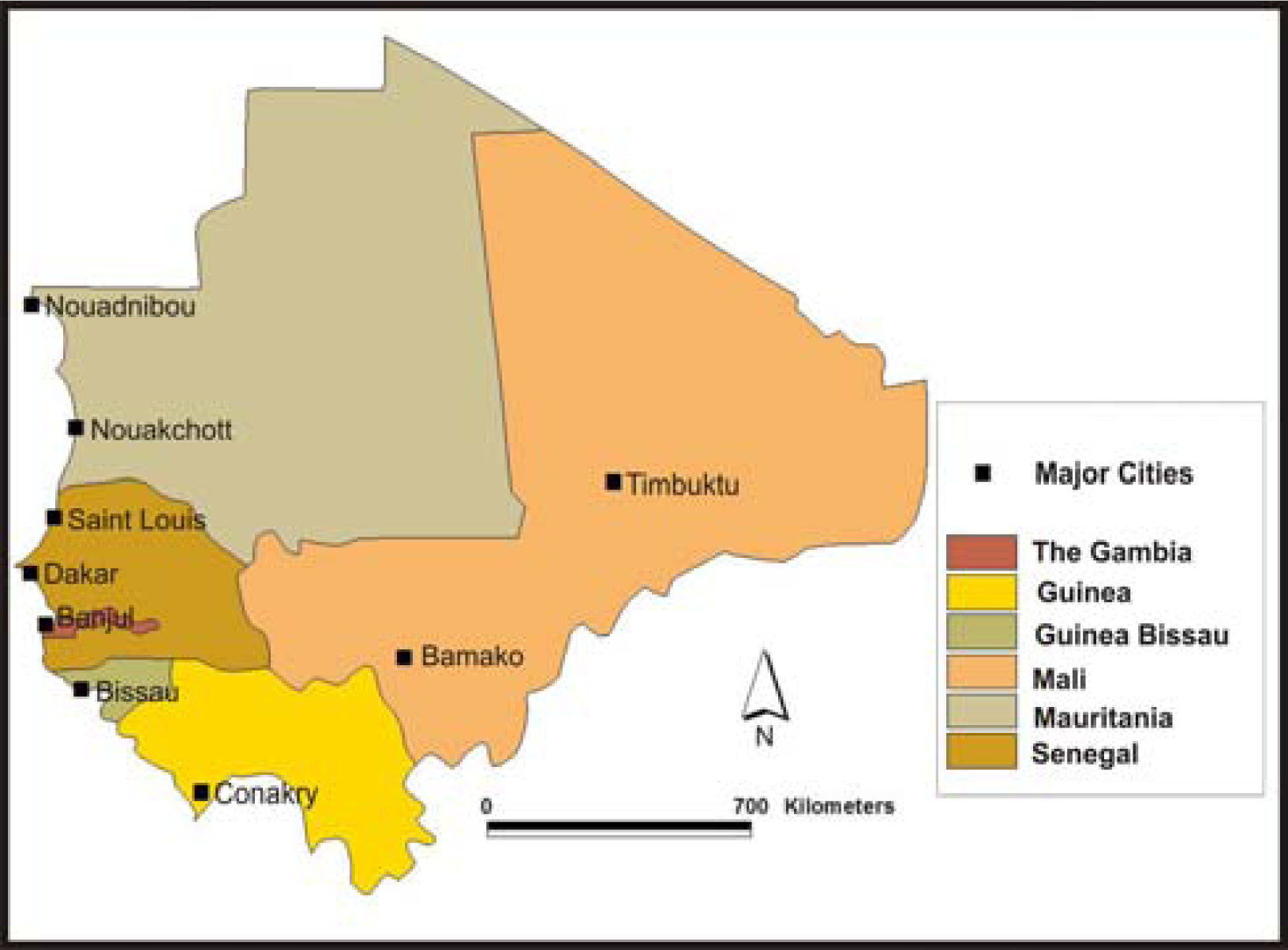
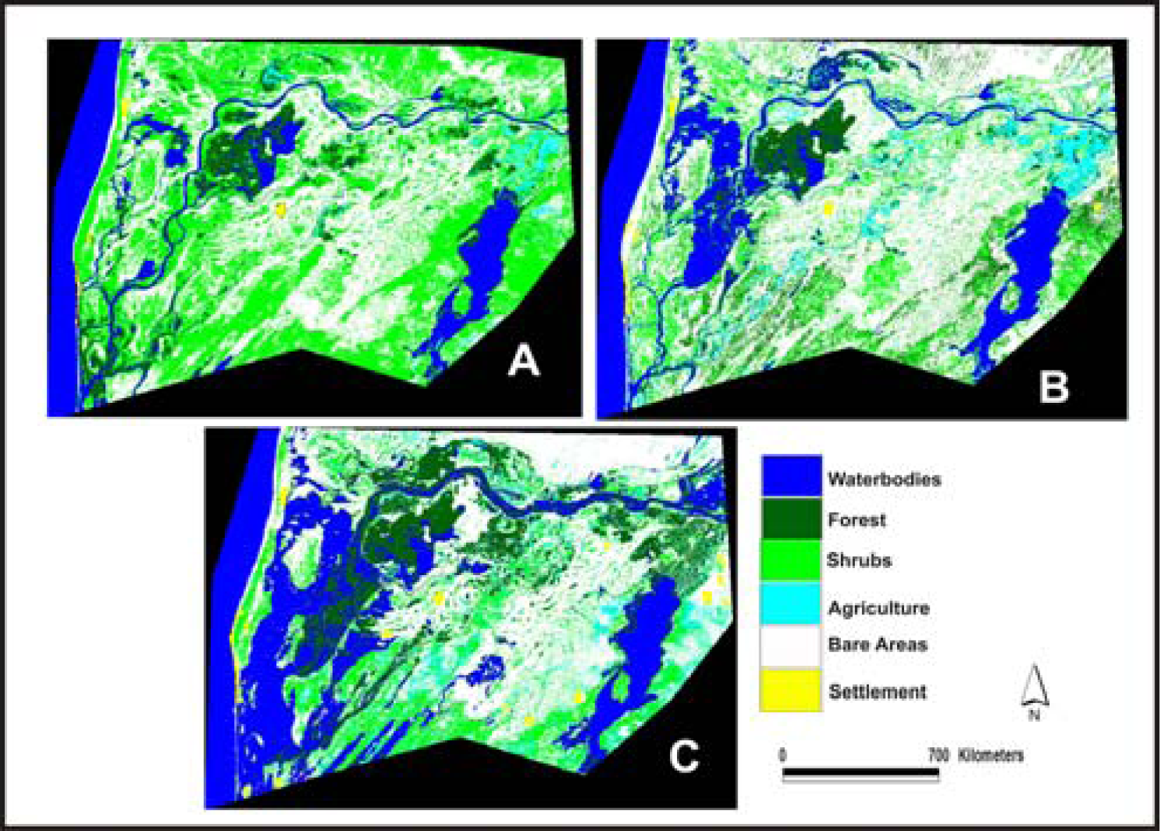
The Senegal River basin shown in
Figures 1 and
2 located in West Africa between latitudes 10’30 and 17‘30 N and longitudes 7’30 and 16’ 30 W, is the second longest river in the region.
The River basin as
Table 1 indicates covers 300,000 Km2 with annual precipitation of 600mm. It is shared by 4 nations most notably Guinea, Mali, Mauritania and Senegal. The breakdown of the physical attributes shows 31,00 km2 (11 percent) of the basin in the Northern plateau of Guinea while 155,000 km2 (53 percent) are situated in Western Mali. The others include 75,500km in Southern Mauritania which accounts for 26 percent of the watershed while the remaining 27,500km in Northern Senegal represent 10 percent of the basin (
Table 2).
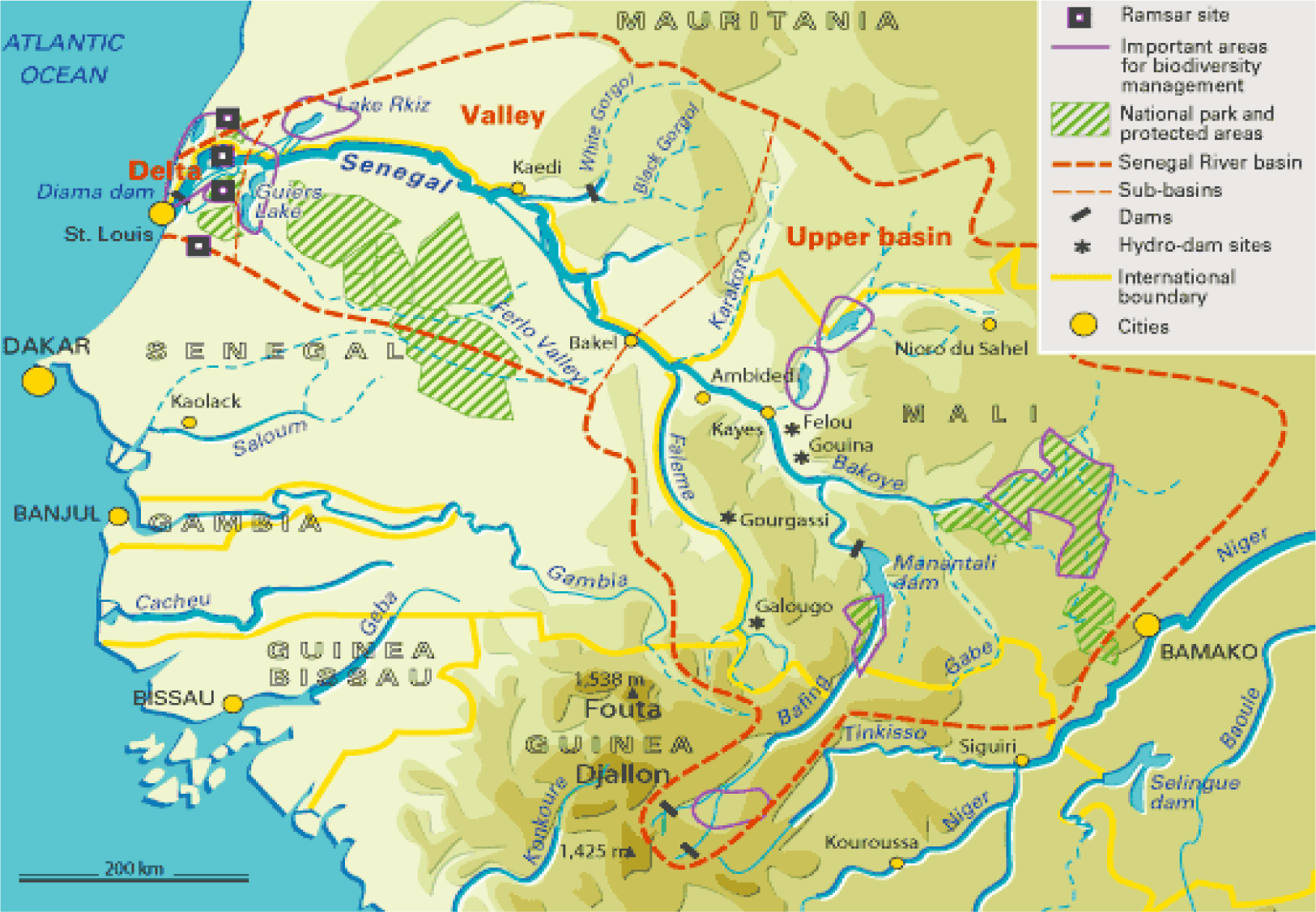
The River originates in the Fouta Djallon Mountain high lands of Guinea and flows through Mali, before forming the boundary between Mauritania and Senegal to its estuary on the Atlantic Ocean. As the lifeline in the Sahel, the drainage length stretches through an area measuring 1,800 kilometers (km)-long. The river and the surrounding valley have supported its population variably throughout the centuries despite very harsh climatic conditions [
2,
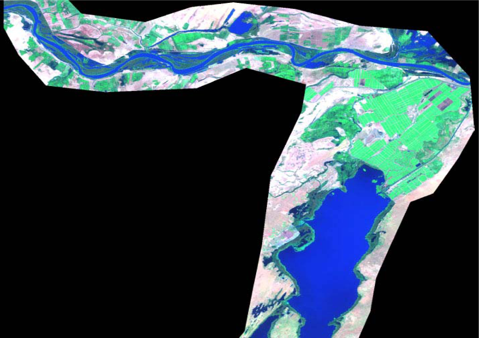
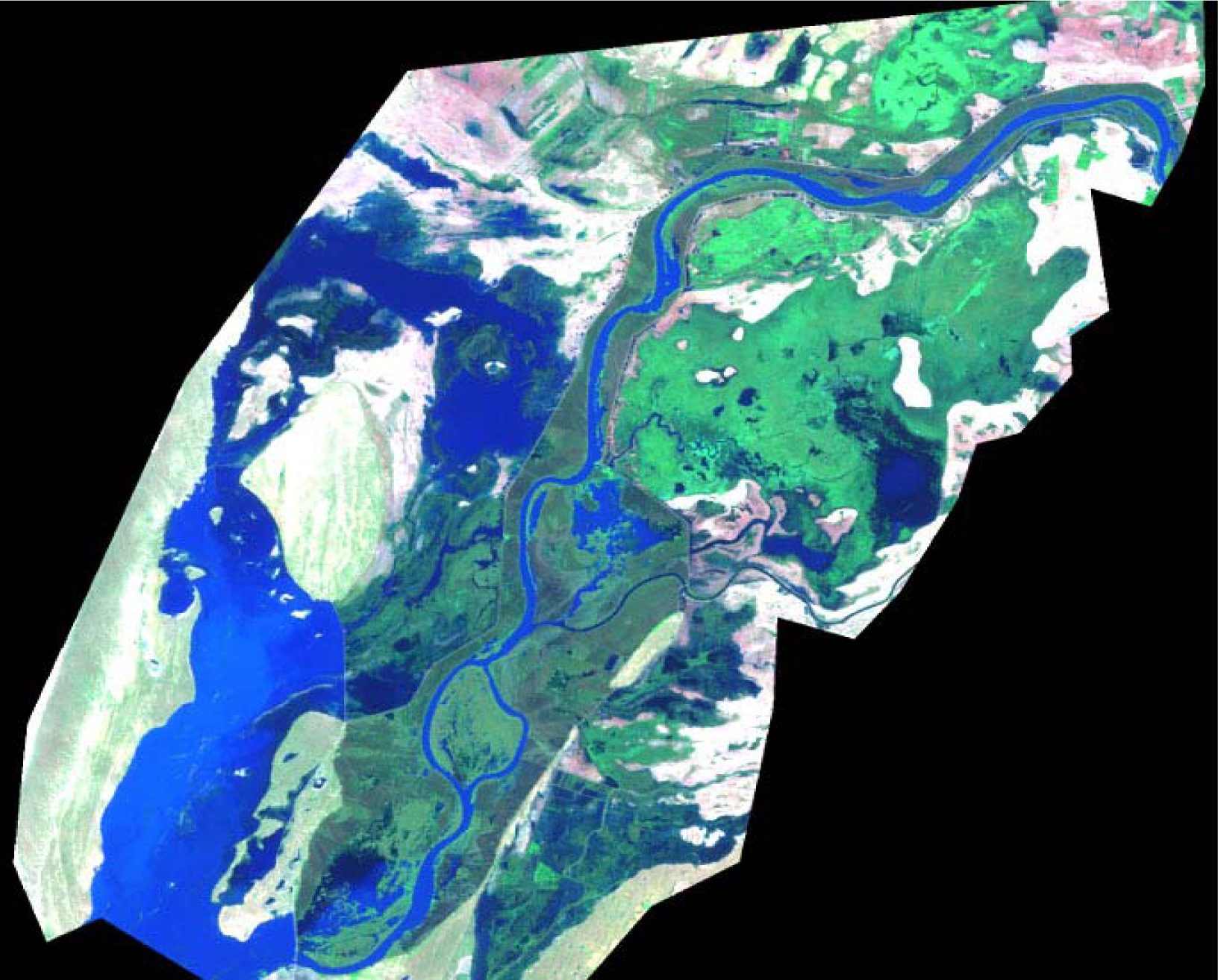
9]. The basin has three distinct parts: 1) the upper basin, which is mountainous, 2) the valley and the delta which are sources of biological diversity and 3) wetlands (
Figure 2). In the three distinct parts of the basin where changes in topographical, hydrological and climatic conditions are quite extensive, rainfall occurs from April-October, while river flooding intensifies between July and October. With much of the flood water originating in the upper valley, during the annual flood, large areas of floodplains are inundated but the area covered varies greatly from year to year. For more information on rain and temperature of the area refer to
Table 4.
As a region with a sub Saharan desert climate that was constantly barraged by long periods of drought during the 1970s, its people were forced to leave the valley in the face of massive starvation and conflict [
9]. During the last few decades as this fragile valley continued to face several climatic problems in the form of severe droughts, extreme population growth, economic decline and unstable food security, there were numerous mass migrations, mainly to the mushrooming cities such as Dakar, Bamako, Conakry and Nouachott with enormous pressures on water resources [
2]. In these places, access to large volumes of drinkable water is not only a touchy concern but is critical for the welfare of the populace and the region’s economy. Based on the current prognosis on climate change, the situation in the area will be compounded in the near future as a result of desertification already threatening the basin [
15].
Over the years, the hydrology of the Senegal River system has changed due to the construction of two dams to alleviate the problems. The Diama Dam, located 27km upstream of St Louis in Senegal and completed in 1985, was designed to prevent the intrusion of saline water from the Atlantic Ocean [
11;
16,
17,
7]. On the other hand, the Manantali Dam in Mali, about 1200km upstream of St Louis, is a hydro-electric dam completed in 1988. With the idea behind the two dams centered on the expansion of irrigated farming along the Senegal River and the delta coupled with electricity generation for urban and industrial development and river navigation [
8], the completion of the dams resulted in negative externalities at the expense of the local population [
18–
21,
7,
17] In fact most people along the delta area suffered the menace of floating aquatic weeds as well as salinization. Even though fishing among the local people has been reported as increasing along the upstream part of the river, construction of the Manatali Dam prevented annual floods needed in traditional recession agriculture [
22,
23].
Regarding socio economic indicators, of the 35 million residents of the area, Mali and Senegal have a slightly identical population of 11 and 10 million, respectively, with Mauritania accounting for 3 million (
Table 3). Among the Basin’s population, of the two million people that live in the Senegal River watershed, about 85% of them rely on the watershed for their livelihoods while approximately 700,000 in riparian communities of the Middle Valley depend on the estuarine environment. The livelihoods of these communities are largely based on traditional production systems mostly linked to the annual flooding cycle. With the population growth of the basin increasing at a rate of about 3 percent per year and slightly higher than the individual averages for the three member states (
Table 3), [
9,
2], countries along the basin remain the worlds’ poorest in relation to both the economy and human capital. Out of 174 countries, Mali ranks 166
th; Senegal ranks 153
rd; and Mauritania ranks 149
th in human development. In terms of UNDP’s human poverty index, of 90 developing countries, Mali ranked 87th; Mauritania ranked 77
th; and Senegal ranked 80th [
12].
With population growth, urbanization and development of human capital already putting extra pressure on river development action in the basin, the proportion of people living in urban areas continues to be highest in Mauritania at 53 percent, followed by Senegal with 51 percent and Mali under 41 percent (
Table 3). Considering that the capitals of these countries are about to grow in the future at astronomical rates, the population of Dakar has been projected to increase from the current 2.4 million to 4.5 million by 2015 [
13]. Similar levels of growth rates have been predicted for Bamako and Nouakchott [
1].
To oversee the affairs of the watershed, the coordination of management activities of the basin falls under the Organization for the Development of Senegal River; or Organization Pour La Mise En Valeur Du Fleuve Senegal (OMVS) often cited as a successful model of regional cooperation for the management of internationally shared water courses [
9]. In 1963, shortly after independence, the nations signed the Bamako Convention for the development of Senegal River Basin. The convention declared the Senegal River an international river and created an interstate committee to oversee its development. Driven by a strong will to cooperate, the countries signed the Labe’ Convention that created the organization for Coastal States of Senegal River (OERS) in 1968. The mandate focused on the development of the basin by facilitating closer coordination beyond water and agricultural sectors. In the following decade, the OMVS came into operation in 1972 with a mission to accelerate economic development through the promotion of interstate cooperation among the riparian countries [
24].
Under the initial arrangements, Mali’s principal interests centered on the maintenance of river levels so as to obtain navigable access to the sea and energy produced by the Manatali Dam. The Mauritanian and Senegalese interests on the other hand converge on the need for power production and irrigation in order to improve livelihoods for local populations [
25]. These varied interests are typical of a transboundary water management situation and the underlying framework. With the mandate of OMVS compounded by numerous challenges [
26], the growing threats posed by changing demographics and widespread poverty[
12,
13] to the basin’s surrounding hydrology and natural environment [
16] now makes the application of geospatial information systems in the management of the basin more urgent than ever. Under this setting, GIS and remote sensing techniques are indispensable in the development of resource management tools for effective policy making and monitoring of the river basin.
Half of the basin is located in Mali, but the main input in terms of water resources comes from the upper basin in Guinea with an average of 1,600 mm of precipitation.
Population figures have been updated based on growth rates in each country for the year 2002. Irrigation is the motor of development of the basin, especially in the valley and the delta. The raising of livestock has always been a major activity. After agriculture, fishing is the second largest economic activity of the basin


