SWAT Modeling of Non-Point Source Pollution in Depression-Dominated Basins under Varying Hydroclimatic Conditions

 , , , and
Abstract
:1. Introduction
2. Materials and Methods
2.1. Study Area
2.2. Water Quantity and Quality Modeling
2.2.1. Model Development
2.2.2. Modeling Scenarios and Calibration Schemes
3. Results
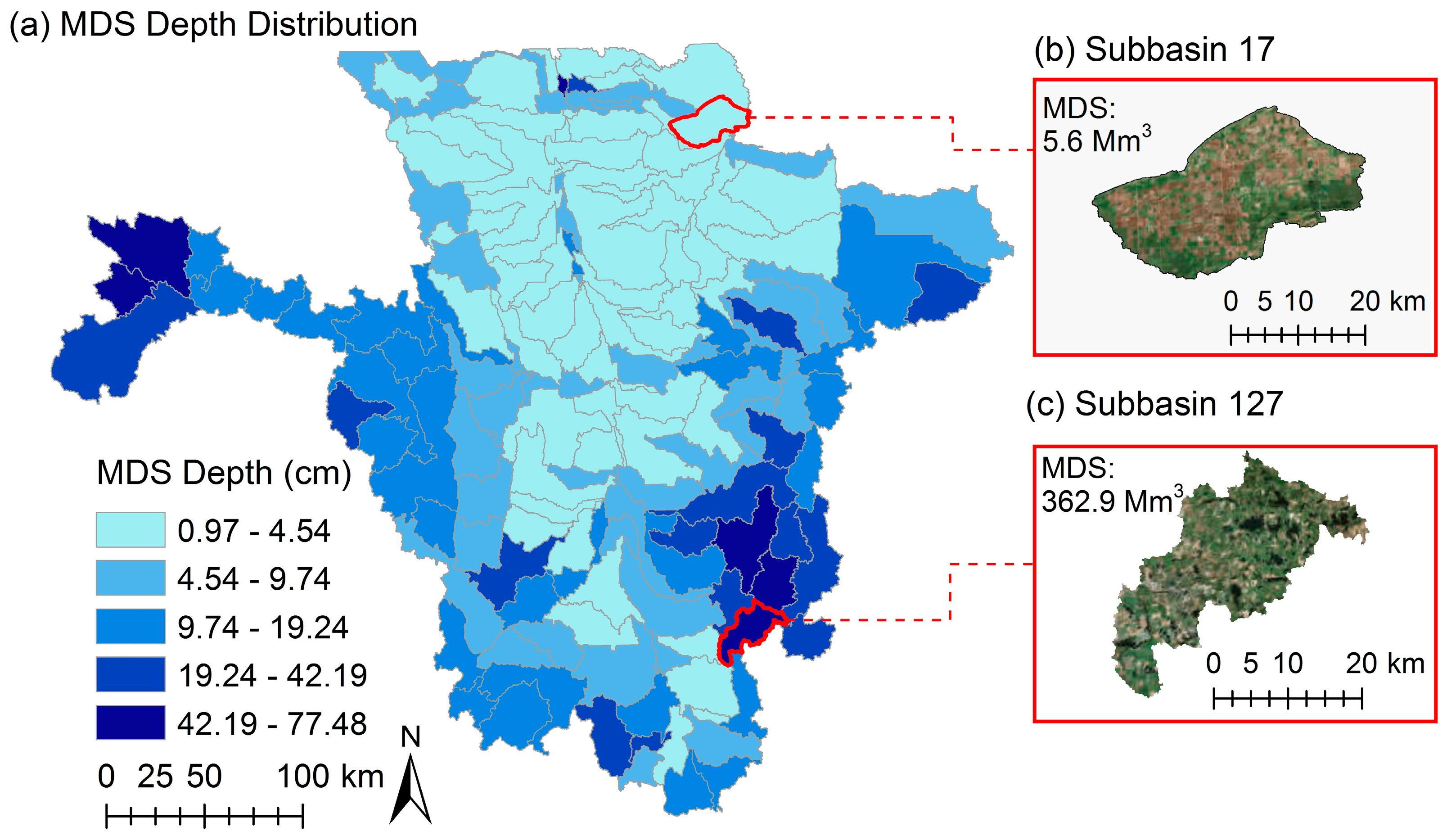
3.1. Watershed Delineation and Depression Storage
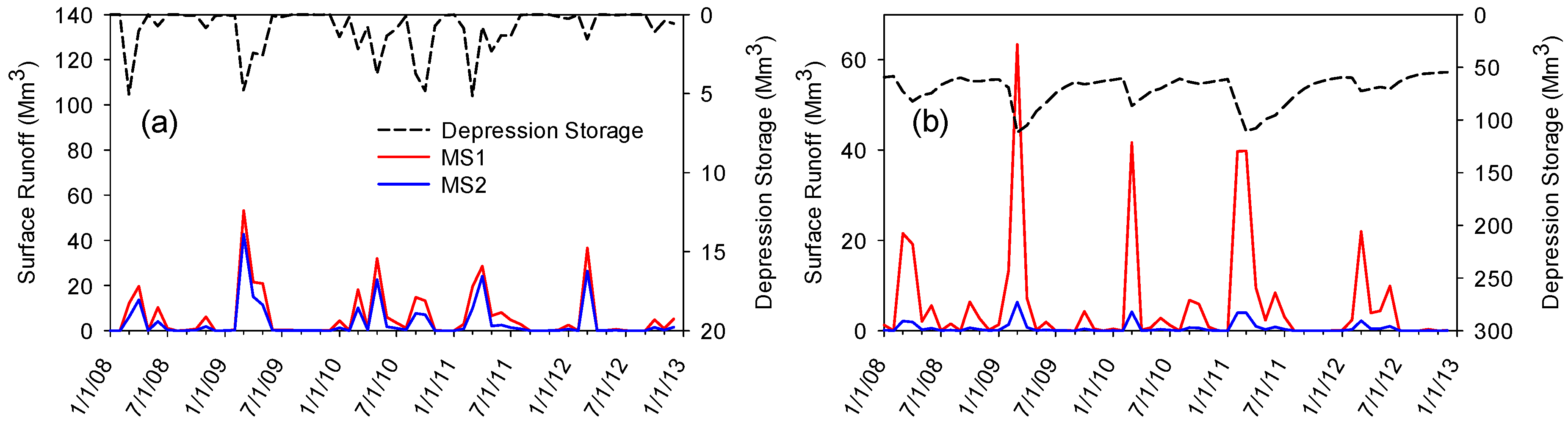
3.2. How Do Depressions Alter Modeling Results?
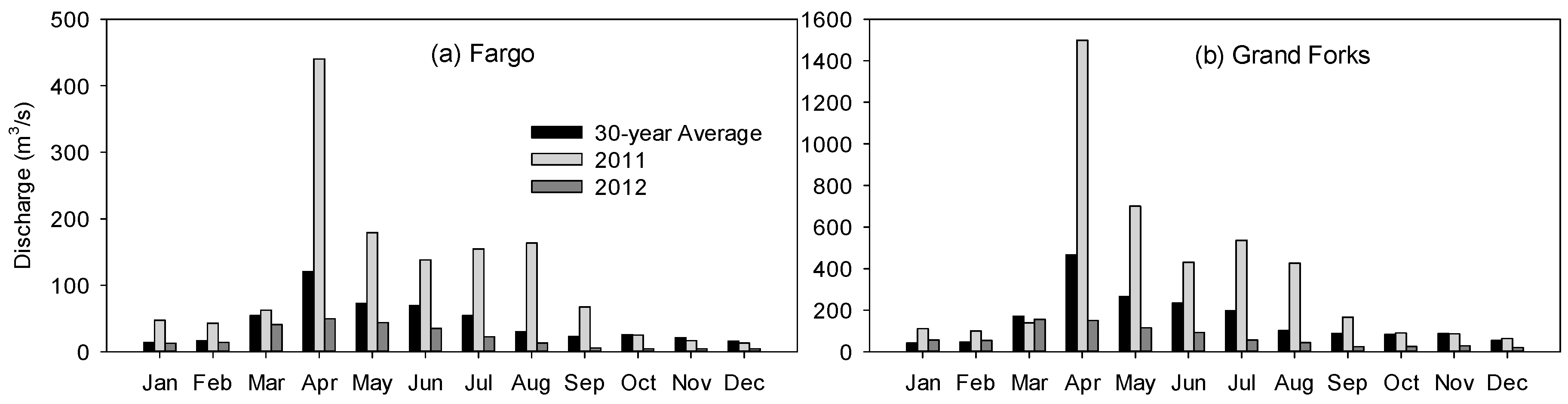
3.3. How Does the Separation of Wet and Dry Years Improve Water Quantity Modeling?
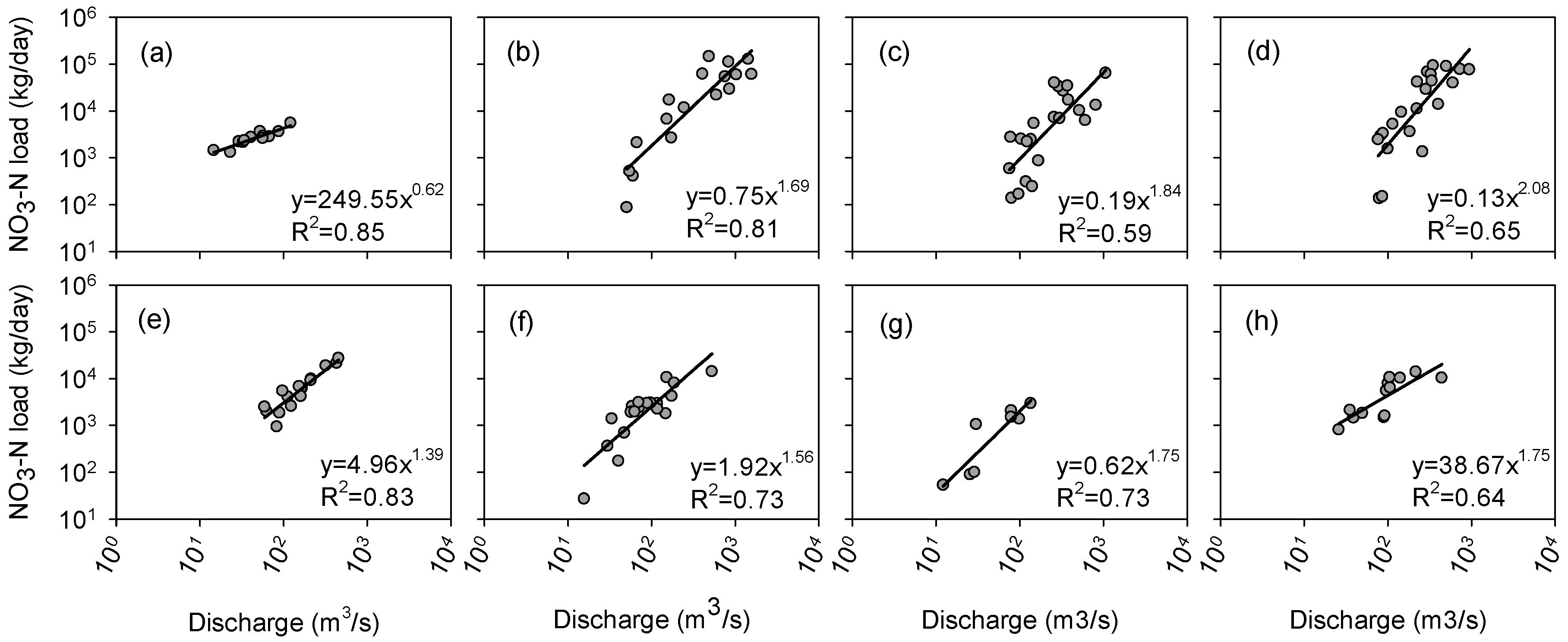
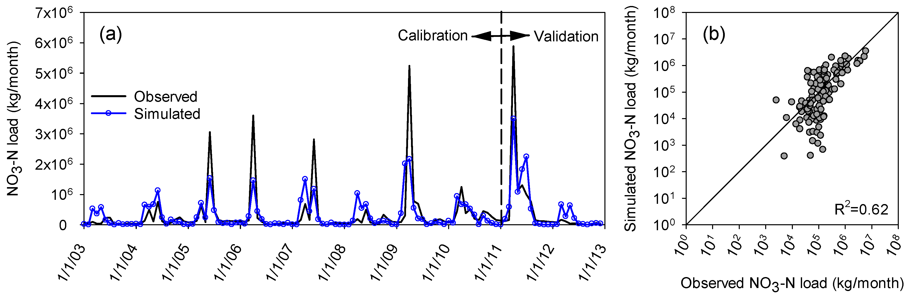
3.4. Water Quality Modeling
4. Discussion
5. Conclusions
Author Contributions
Funding
Acknowledgments
Conflicts of Interest
References
- Carpenter, S.R.; Caraco, N.F.; Correll, D.L.; Howarth, R.W.; Sharpley, A.N.; Smith, V.H. Nonpoint pollution of surface waters with phosphorus and nitrogen. Ecol. Appl. 1998, 8, 559–568. [Google Scholar] [CrossRef]
- Smith, V.H. Environmental Indicators of Water Quality in the United States; EPA 841-R-96-002; USEPA, Office of Water (4503F), U.S. Government Printing Office: Washington, DC, USA, 1996.
- Dowd, B.M.; Press, D.; Huertos, M.L. Agricultural nonpoint source water pollution policy: The case of California’s Central Coast. Agric. Ecosyst. Environ. 2008, 128, 151–161. [Google Scholar] [CrossRef]
- Ongley, E.D.; Xiaolan, Z.; Tao, Y. Current status of agricultural and rural non-point source pollution assessment in China. Environ. Pollut. 2010, 158, 1159–1168. [Google Scholar] [CrossRef] [PubMed]
- Minnesota Pollution Control Agency More about Section 319 Program. Available online: https://www.pca.state.mn.us/water/more-about-section-319-program (accessed on 6 March 2018).
- USEPA. National Management Measures to Control Nonpoint Source Pollution from Agriculture; EPA-841-B-03-004; US Environmental Protection Agency, Office of Water: Washington, DC, USA, 2003.
- USEPA. National Evaluation of the Clean Water Act Section 319 Program; U.S. Environmental Protection Agency, Office of Wetlands, Oceans, & Watersheds: Washington, DC, USA, 2011.
- Borah, D.K.; Bera, M. Watershed-scale hydrologic and nonpoint-source pollution models: Review of mathematical bases. Trans. ASAE 2003, 46, 1553–1566. [Google Scholar] [CrossRef]
- Borah, D.K.; Bera, M. Watershed-scale hydrologic and nonpoint-source pollution models: Review of applications. Trans. ASAE 2004, 47, 789–803. [Google Scholar] [CrossRef]
- Arnold, J.G.; Srinivasan, R.; Muttiah, R.S.; Williams, J.R. Large area hydrologic modeling and assessment Part I: Model development. J. Am. Water Resour. Assoc. 1998, 34, 73–89. [Google Scholar] [CrossRef]
- Srinivasan, R.; Ramanarayanan, T.S.; Arnold, J.G.; Bednarz, S.T. Large area hydrologic modeling and assessment Part II: Model application. J. Am. Water Resour. Assoc. 1998, 34, 91–101. [Google Scholar] [CrossRef]
- Bicknell, B.R.; Imhoff, J.C.; Kittle, J.L., Jr.; Jobes, T.H.; Donigian, A.S., Jr.; Johanson, R. Hydrological Simulation Program-Fortran (HSPF): User’s Manual for Release 10; Report No. EPA/600/R-93/174; U.S. EPA Environmental Research Lab: Athens, GA, USA, 1993.
- Bingner, R.L.; Theurer, F.D.; Yuan, Y. AnnAGNPS Technical Processes Version 5.4; USDA-ARS, National Sedimentation Laboratory: Oxford, MS, USA, 2015.
- Jayakrishnan, R.; Srinivasan, R.; Santhi, C.; Arnold, J.G. Advances in the application of the SWAT model for water resources management. Hydrol. Process. 2005, 19, 749–762. [Google Scholar] [CrossRef]
- Licciardello, F.; Zema, D.A.; Zimbone, S.M.; Bingner, R.L. Runoff and Soil Erosion Evaluation by the AnnAGNPS Model in a Small Mediterranean Watershed. Trans. ASABE 2007, 50, 1585–1593. [Google Scholar] [CrossRef]
- Diaz-Ramirez, J.N.; McAnally, W.H.; Martin, J.L. Analysis of Hydrological Processes Applying the HSPF Model in Selected Watersheds in Alabama, Mississippi, and Puerto Rico. Appl. Eng. Agric. 2011, 27, 937–954. [Google Scholar] [CrossRef]
- Tahmasebi Nasab, M.; Singh, V.; Chu, X. SWAT Modeling for Depression-Dominated Areas: How Do Depressions Manipulate Hydrologic Modeling? Water 2017, 9, 58. [Google Scholar] [CrossRef]
- Habtezion, N.; Tahmasebi Nasab, M.; Chu, X. How does DEM resolution affect microtopographic characteristics, hydrologic connectivity, and modeling of hydrologic processes? Hydrol. Process. 2016, 30, 4870–4892. [Google Scholar] [CrossRef]
- Tahmasebi Nasab, M.; Grimm, K.; Wang, N.; Chu, X. Scale Analysis for Depression-Dominated Areas: How Does Threshold Resolution Represent a Surface? In World Environmental and Water Resources Congress 2017; American Society of Civil Engineers: Reston, VA, USA, 2017; pp. 164–174. [Google Scholar]
- Planchon, O.; Darboux, F. A fast, simple and versatile algorithm to fill the depressions of digital elevation models. Catena 2002, 46, 159–176. [Google Scholar] [CrossRef]
- Chu, X.; Zhang, J.; Chi, Y.; Yang, J. An Improved Method for Watershed Delineation and Computation of Surface Depression Storage. In Watershed Management 2010; American Society of Civil Engineers: Reston, VA, USA, 2010; pp. 1113–1122. [Google Scholar]
- Tahmasebi Nasab, M.; Zhang, J.; Chu, X. A new depression-dominated delineation (D-cubed) method for improved watershed modeling. Hydrol. Process. 2017, 31, 3364–3378. [Google Scholar] [CrossRef]
- Yang, J.; Chu, X. Quantification of the spatio-temporal variations in hydrologic connectivity of small-scale topographic surfaces under various rainfall conditions. J. Hydrol. 2013, 505, 65–77. [Google Scholar] [CrossRef]
- Tahmasebi Nasab, M.; Jia, X.; Chu, X. Modeling of Subsurface Drainage under Varying Microtopographic, Soil and Rainfall Conditions. In 10th International Drainage Symposium; Strock, J., Ed.; American Society of Agricultural and Biological Engineers: Minneapolis, MN, USA, 2016; pp. 133–138. [Google Scholar]
- Chu, X.; Yang, J.; Chi, Y.; Zhang, J. Dynamic puddle delineation and modeling of puddle-to-puddle filling-spilling-merging-splitting overland flow processes. Water Resour. Res. 2013, 49, 3825–3829. [Google Scholar] [CrossRef] [Green Version]
- Wang, X.; Yang, W.; Melesse, A.M. Using Hydrologic Equivalent Wetland Concept Within SWAT to Estimate Streamflow in Watersheds with Numerous Wetlands. Trans. ASABE 2008, 51, 55–72. [Google Scholar] [CrossRef]
- Mekonnen, B.A.; Mazurek, K.A.; Putz, G. Incorporating landscape depression heterogeneity into the Soil and Water Assessment Tool (SWAT) using a probability distribution. Hydrol. Process. 2016, 30, 2373–2389. [Google Scholar] [CrossRef]
- Lin, Z.; Anar, M.J.; Zheng, H. Hydrologic and water-quality impacts of agricultural land use changes incurred from bioenergy policies. J. Hydrol. 2015, 525, 429–440. [Google Scholar] [CrossRef]
- Li, L.; Zhang, L.; Wang, H.; Wang, J.; Yang, J.-W.; Jiang, D.-J.; Li, J.-Y.; Qin, D.-Y. Assessing the impact of climate variability and human activities on streamflow from the Wuding River basin in China. Hydrol. Process. 2007, 21, 3485–3491. [Google Scholar] [CrossRef] [Green Version]
- Gao, X.; Chen, X.; Biggs, T.; Yao, H. Separating wet and dry years to improve calibration of SWAT in Barrett Watershed, Southern California. Water 2018, 10, 274. [Google Scholar] [CrossRef]
- Cohen, M.J.; Creed, I.F.; Alexander, L.; Basu, N.B.; Calhoun, A.J.K.; Craft, C.; D’Amico, E.; DeKeyser, E.; Fowler, L.; Golden, H.E.; et al. Do geographically isolated wetlands influence landscape functions? Proc. Natl. Acad. Sci. USA 2016, 113, 1978–1986. [Google Scholar] [CrossRef] [PubMed] [Green Version]
- Chu, X. Delineation of Pothole-Dominated Wetlands and Modeling of Their Threshold Behaviors. J. Hydrol. Eng. 2015, 22, D5015003. [Google Scholar] [CrossRef]
- LaBaugh, J.W.; Rosenberry, D.O.; Mushet, D.M.; Neff, B.P.; Nelson, R.D.; Euliss, N.H. Long-Term changes in pond permanence, size, and salinity in Prairie Pothole Region wetlands: The role of groundwater-pond interaction. J. Hydrol. Reg. Stud. 2018, 17, 1–23. [Google Scholar] [CrossRef]
- Red River Basin Board. Inventory Team Report: Hydrology; Red River Basin Board: Moorhead, MN, USA, 2000. [Google Scholar]
- Jin, C.X.; Sands, G.R.; Kandel, H.J.; Wiersma, J.H.; Hansen, B.J. Influence of Subsurface Drainage on Soil Temperature in a Cold Climate. J. Irrig. Drain. Eng. 2008, 134, 83–88. [Google Scholar] [CrossRef]
- Rahman, M.M.; Lin, Z.; Jia, X.; Steele, D.D.; DeSutter, T.M. Impact of subsurface drainage on streamflows in the Red River of the North basin. J. Hydrol. 2014, 511, 474–483. [Google Scholar] [CrossRef]
- Wazney, L.; Clark, S.P. The 2009 flood event in the Red River Basin: Causes, assessment and damages. Can. Water Resour. J./Rev. Can. Ressour. Hydriques 2016, 41, 56–64. [Google Scholar] [CrossRef]
- Boryan, C.; Yang, Z.; Mueller, R.; Craig, M. Monitoring US agriculture: The US Department of Agriculture, National Agricultural Statistics Service, Cropland Data Layer Program. Geocarto Int. 2011, 26, 341–358. [Google Scholar] [CrossRef]
- Stoner, J.D.; Lorenz, D.L.; Goldstein, R.M.; Brigham, M.E.; Cowdery, T.K. Water Quality in the Red River of the North Basin, Minnesota, North Dakota, and South Dakota, 1992–1995. U.S. Geological Survey Circular 1169. Available online: https://pubs.usgs.gov/circ/circ1169 (accessed on 6 November 2018).
- Neitsch, S.; Arnold, J.; Kiniry, J.; Williams, J. Soil and Water Assessment Tool (SWAT) Theoretical Documentation Version 2009; Texas Water Resources Institute: College Station, TX, USA, 2011. [Google Scholar]
- Ikenberry, C.D.; Crumpton, W.G.; Arnold, J.G.; Soupir, M.L.; Gassman, P.W. Evaluation of Existing and Modified Wetland Equations in the SWAT Model. JAWRA J. Am. Water Resour. Assoc. 2017, 53, 1267–1280. [Google Scholar] [CrossRef] [Green Version]
- Fuka, D.R.; Walter, M.T.; MacAlister, C.; Degaetano, A.T.; Steenhuis, T.S.; Easton, Z.M. Using the Climate Forecast System Reanalysis as weather input data for watershed models. Hydrol. Process. 2014, 28, 5613–5623. [Google Scholar] [CrossRef]
- United States Geological Survey (USGS) National Map Viewer. Available online: https://viewer.nationalmap.gov/basic/ (accessed on 3 May 2017).
- ESRI (Environmental Systems Research Institute). ArcGIS Desktop: Release 10; Environmental Systems Research Institute: Redlands, CA, USA, 2011. [Google Scholar]
- Python 2.7. Available online: https://www.python.org/ (accessed on 10 May 2018).
- STATSGO2 Database, Natural Resources Conservation Service, United States Department of Agriculture. Web Soil Survey. Available online: http://websoilsurvey.nrcs.usda.gov/ (accessed on 10 May 2017).
- North Dakota Fertilizer Recommendation Tables and Equations. Available online: https://www.ag.ndsu.edu/publications/crops/north-dakota-fertilizer-recommendation-tables-and-equations (accessed on 8 April 2017).
- Chu, X.; Lin, Z.; Tahmasebi Nasab, M.; Zeng, L.; Grimm, K.; Bazrkar, M.H.; Wang, N.; Liu, X.; Zhang, X.; Zheng, H. Macro-scale grid-based and subbasin-based hydrologic modeling: Joint simulation and cross-calibration. J. Hydroinform. 2018. [Google Scholar] [CrossRef]
- Abbaspour, K.C. SWAT-CUP 2012: SWAT Calibration and Uncertainty Program—A User Manual; EAWAG Swiss Federal Institute of Aquatic Science and Technology: Dübendorf, Switzerland, 2013. [Google Scholar]
- Moriasi, D.N.; Arnold, J.G.; Van Liew, M.W.; Bingner, R.L.; Harmel, R.D.; Veith, T.L. Model evaluation guidelines for systematic quantification of accuracy in watershed simulations. Trans. ASABE 2007, 50, 885–900. [Google Scholar] [CrossRef]
- Moriasi, D.N.; Zeckoski, R.W.; Arnold, J.G.; Baffaut, C.; Malone, R.W.; Daggupati, P.; Guzman, J.A.; Saraswat, D.; Yuan, Y.; Wilson, B.N.; et al. Hydrologic and Water Quality Models: Key Calibration and Validation Topics. Trans. ASABE 2015, 58, 1609–1618. [Google Scholar] [CrossRef] [Green Version]
- Nash, J.E.; Sutcliffe, J.V. River flow forecasting through conceptual models part I—A discussion of principles. J. Hydrol. 1970, 10, 282–290. [Google Scholar] [CrossRef]
- Ludden, A.P.; Frink, D.L.; Johnson, D.H. Water storage capacity of natural wetland depressions in the Devils Lake Basin of North Dakota. J. Soil Water Conserv. 1983, 38, 45–48. [Google Scholar]
- Stadnyk, T.; Dow, K.; Wazney, L.; Blais, E.-L. The 2011 flood event in the Red River Basin: Causes, assessment and damages. Can. Water Resour. J./Rev. Can. Ressour. Hydriques 2016, 41, 65–73. [Google Scholar] [CrossRef]


| Station | Wet Years | Dry Years |
|---|---|---|
| Drayton | 1996, 1997, 1999, 2001, 2005, 2009, 2010, 2011 | 1994, 1995, 1998, 2000, 2002, 2003, 2004, 2006, 2007, 2008, 2012 |
| Grand Forks | 1997, 1999, 2001, 2009, 2010, 2011 | 1994, 1995, 1996, 1998, 2000, 2002, 2003, 2004, 2005, 2006, 2007, 2008, 2012 |
| Fargo | 1997, 1998, 2001, 2005, 2007, 2009, 2010, 2011 | 1994, 1995, 1996, 1999, 2000, 2002, 2003, 2004, 2006, 2008, 2012 |
| Doran | 1995, 1997, 2001, 2005, 2006, 2007, 2009, 2010, 2011 | 1994, 1996, 1998, 1999, 2000, 2002, 2003, 2004, 2008, 2012 |
| Station | CS1 | CS2 | |||
|---|---|---|---|---|---|
| NSE | PBIAS (%) | NSE | PBIAS (%) | ||
| Drayton | Calibration | 0.55 | 24.86 | 0.62 | 11.95 |
| Validation | 0.65 | 15.01 | 0.73 | −4.33 | |
| Grand Forks | Calibration | 0.55 | 24 | 0.71 | 11.81 |
| Validation | 0.67 | 14.94 | 0.77 | −0.59 | |
| Fargo | Calibration | 0.51 | 21.8 | 0.70 | 7.25 |
| Validation | 0.41 | 26.27 | 0.62 | 12.97 | |
| Doran | Calibration | 0.40 | 28.53 | 0.57 | 56.28 |
| Validation | −0.04 | 44.83 | −0.04 | 34.17 | |
| Parameter * | Process | Unit | Initial Range | CS1 | CS2 | |
|---|---|---|---|---|---|---|
| Wet | Dry | |||||
| CN2 | Surface runoff | % change | [−20, 20] | [−16.59, 12.59] | [0.31, 8.37] | [−6.45, 2.28] |
| ALPHA_BF | Groundwater | 1/day | [0, 1] | [0.01, 0.68] | [0.79, 0.91] | [0.06, 0.38] |
| SOL_AWC | Soil water | % change | [−40, 40] | [−18.53, 24.54] | [21.97, 37.15] | [−12.71, 8.25] |
| GW_REVAP | Groundwater | - | [0.02, 0.2] | [0.18, 0.20] | [0.04, 0.11] | [0.07, 0.16] |
| SMTMP | Snow | °C | [−5, 5] | [1.72, 4.92] | [2.74, 4.87] | [−0.20, 1.34] |
| SMFMX | Snow | mm/day-°C | [0, 10] | [2.41, 6.41] | [3.71, 6.64] | [3.10, 6.04] |
| SMFMN | Snow | mm/day-°C | [0, 10] | [−1.23, 5.01] | [1.78, 4.52] | [0.01, 1.54] |
| ESCO | Soil evaporation | - | [0.01, 1] | [0.11, 0.37] | [0.42, 0.64] | [0.05, 0.15] |
| WET_K | Wetlands | mm/h | [0, 1] | [0.29, 0.92] | [0.79, 0.94] | [0.20, 0.67] |
| RS3 | Water quality | mg/(m²day) | [0, 1] | - | [0.05, 0.15] | [0.05, 0.10] |
| BC1 | Water quality | 1/day | [0.1, 1] | - | [0.50, 0.60] | [0.10, 0.11] |
| BC2 | Water quality | 1/day | [0.2, 2] | - | [0.20, 0.30] | [0.20, 0.22] |
| BC3 | Water quality | 1/day | [0.2, 0.4] | - | [0.20, 0.22] | [0.20, 0.22] |
© 2018 by the authors. Licensee MDPI, Basel, Switzerland. This article is an open access article distributed under the terms and conditions of the Creative Commons Attribution (CC BY) license (http://creativecommons.org/licenses/by/4.0/).
Share and Cite
Tahmasebi Nasab, M.; Grimm, K.; Bazrkar, M.H.; Zeng, L.; Shabani, A.; Zhang, X.; Chu, X. SWAT Modeling of Non-Point Source Pollution in Depression-Dominated Basins under Varying Hydroclimatic Conditions. Int. J. Environ. Res. Public Health 2018, 15, 2492. https://doi.org/10.3390/ijerph15112492
Tahmasebi Nasab M, Grimm K, Bazrkar MH, Zeng L, Shabani A, Zhang X, Chu X. SWAT Modeling of Non-Point Source Pollution in Depression-Dominated Basins under Varying Hydroclimatic Conditions. International Journal of Environmental Research and Public Health. 2018; 15(11):2492. https://doi.org/10.3390/ijerph15112492
Chicago/Turabian StyleTahmasebi Nasab, Mohsen, Kendall Grimm, Mohammad Hadi Bazrkar, Lan Zeng, Afshin Shabani, Xiaodong Zhang, and Xuefeng Chu. 2018. "SWAT Modeling of Non-Point Source Pollution in Depression-Dominated Basins under Varying Hydroclimatic Conditions" International Journal of Environmental Research and Public Health 15, no. 11: 2492. https://doi.org/10.3390/ijerph15112492