3.2.1. Overall Characteristics of Historic Land Cover Change
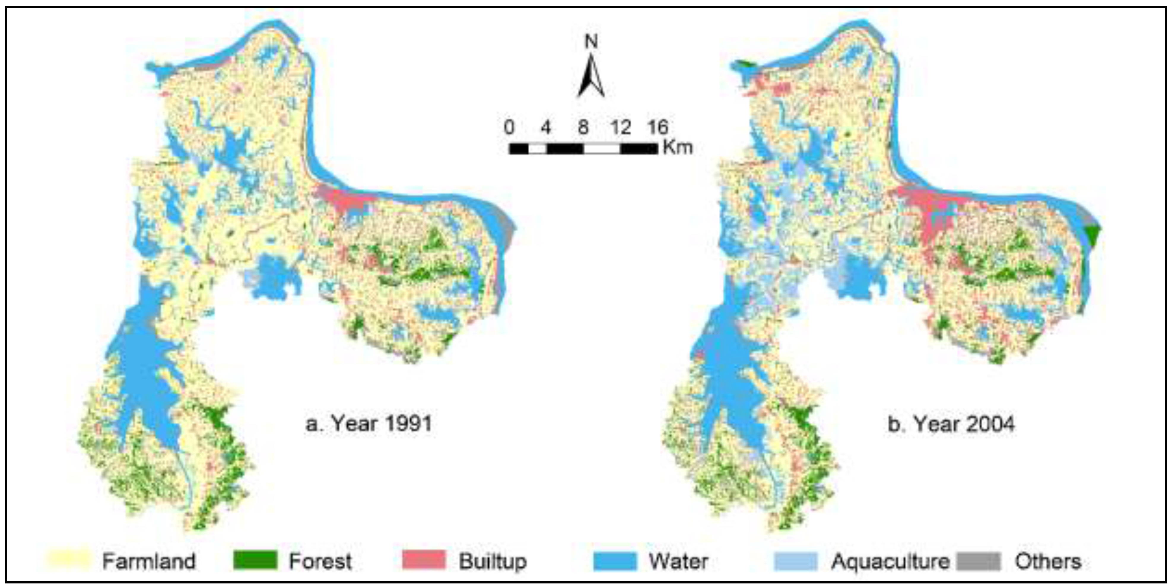
Our study region from 1991 to 2013 experienced substantial land cover change (see
Table 1 and
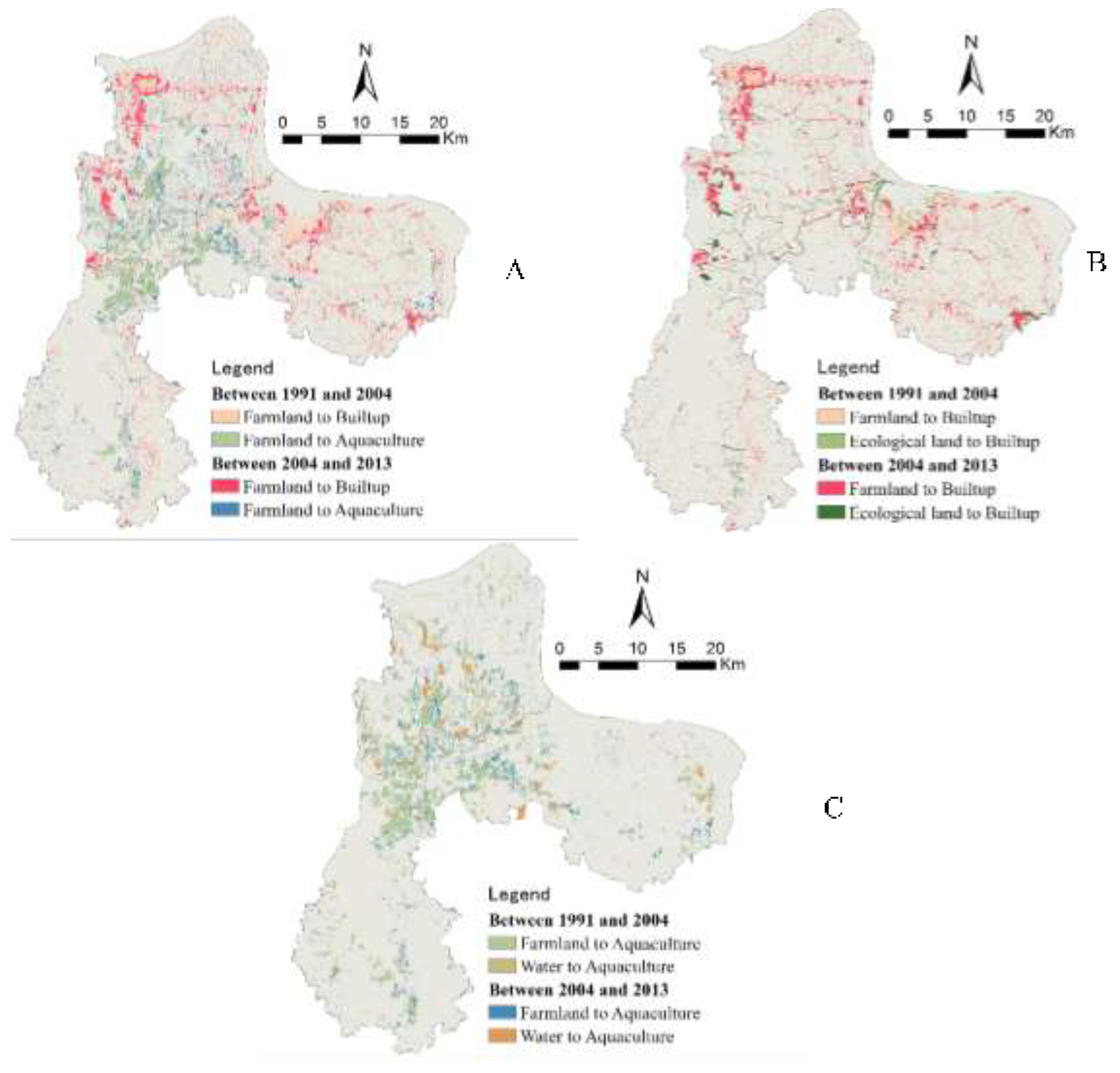
Figure 5), which led to severe loss of farmlands, rapid increase in built-up lands and aquaculture water bodies. First, while farmland is the dominant land cover type in our study area, the total area of farmland tends to decrease over time. The proportion of farmlands decreases from 54% in 1991 to 38% in 2013, corresponding to a loss of 26,163 hectares (30%). From the spatial distribution of farmland loss (see
Figure 5a), we could observe that lost farmlands cluster in the middle of the study region (Hongxie Lake, BailiChangGang), in the downtown area of Ezhou City, and the Gedian Economic Development Zone. Second, in 1991, the percentage of built-up lands in our study region is only 8%. In 2013, this percentage reaches 17%, a net increase of 13,856 hectares (102% of net gain). In particular, built-up lands significantly increased between 2004 and 2013. Observed from the map of build-up land (
Figure 5b), this change occurred in the northwestern part of the study region (close to Wuhan City), southeastern, and central city region of Ezhou City. Our field investigation revealed that an increase in built-up land generally falls within regions planned for development. Third, from 1991 to 2004, the proportion of aquaculture water bodies increased from the original 5% to 12% (169% net increase;
i.e., 12,494 hectares). From 2004–2013, aquaculture water bodies remain stable. This pattern can be attributed to the structural adjustment of regional agriculture and markets. Our study area is characterized by rich water resources. Between 1991 and 2004, driven by an increase in market revenue from aquaculture compared to farming, a large number of water bodies, including ponds, were converted for aquaculture (e.g., fish, shells, and lotus). After this period, as market revenue from aquaculture tends to be stable, the area of aquaculture water bodies remains almost unchanged. Increase in aquaculture water bodies mainly clustered in the middle of the study region (see
Figure 5c), dominated by dense stream networks.
3.2.2. Land Use Transition
The Markov transition matrices allow us to investigate conversions among specific land cover types, serving as a form of disturbance to landscape patterns. From Markov transition matrices in
Table 2 and
Table 3, we have the following findings.
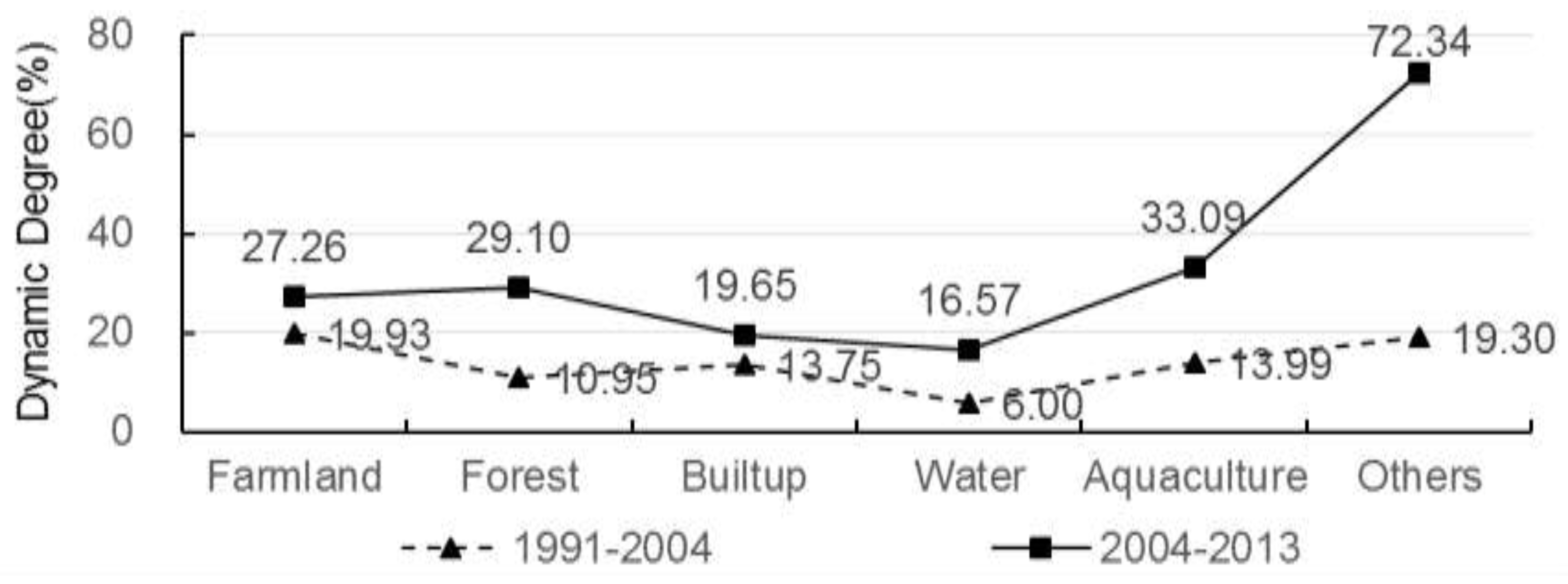
Intensive occupation of farmlands due to urban-rural expansion: From 1991 to 2004, 5256 hectares (5.98%) of farmlands were converted to built-up lands. From 2004–2013, the area of farmlands converted to built-up lands is 7686 hectares (10.74%). From 1991 to 2013, the total area of farmlands converted to built-up lands is 12,843 hectares (16.72%). Thus, we could see that over different periods urban-rural expansion consumed large amounts of farmlands and this trend tends to be accelerated. This indicates that our study region, as a key part of the Greater Wuhan Metropolitan Region, has experienced rapid land development, imposing substantial influence on the socio-ecological environment. Ezhou is also a major region for grain in central China. The intensive occupation of farmlands will pose a severe threat for regional food security. Meanwhile, under the national policy of “requisition-compensation balance”, large amounts of rangelands or other lands were converted into low-quality farmland, which tends to degrade the environment of the study region.
Increase in conversion of ecological lands into built-up: From 1991 to 2004, about 1293 hectares of ecological land types (e.g., forest, water bodies, and aquaculture) were converted into built-up—i.e., about 18.21% of land conversion. From 2004–2013, 3371 hectares of lands were converted into built-up (27.32% of land conversion). This means that ecological lands are becoming targets of urban-rural expansion, stimulated by strict farmland protection and large demands of built-up lands. This will potentially impose negative impacts on the development of ecologically representative regions in Ezhou City, which need new policies to prevent the continual loss of ecological lands.
Frequent conversion between farmlands and aquaculture water bodies: From 1991 to 2004, about 13,526 hectares of lands were converted to aquaculture, 83.16% from farmlands. Yet, only 158 hectares of aquaculture water bodies were converted into farmlands. From 2004–2013, the area of the lands converted into aquaculture water bodies is 8320 hectares (55.14% from farmlands). Under the policy of strict farmland protection and agriculture subsidy as well as a decrease in revenue from aquaculture markets, about 3625 hectares of aquaculture water bodies were converted back to farmlands. In total, the area of farmlands converted to aquaculture water bodies is 12,449 hectares and the area of aquaculture water bodies converted from farmlands is 3625 hectares. This shows a frequent conversion between farmlands and aquaculture water bodies. This conversion will adversely affect the landscape characteristics and quality of farmlands, which is neither good for landscape-level ecological security nor for the productivity of farmlands.
Conversion of water bodies for aquaculture: From 1991 to 2013, 3557 hectares of water bodies were converted for aquaculture purpose. However, only 294 hectares of aquaculture water bodies were converted back to regular water bodies. While conversion between regular water bodies and aquaculture ones is reversible, the large number of conversion tends to increase landscape vulnerability and its associated ecological risk.
Impact of policies: From 1991 to 2004, only 425 hectares of farmlands were converted into forests, yet this conversion reaches 4495 hectares from 2004 to 2013. This significant increase shows that the protection policies such as conversion of farmlands into forests for ecological restoration (Grain for Green program started in 1999) and requisition-compensation balance (started in 1997) are effective.
Conversion of other land: In this study, other land cover types include orchard, rangeland, wetlands, and other open space. From 1991 to 2004, about 1687 hectares of other lands were converted to forests, built-up, farmlands, and aquaculture. From 2004 to 2013, 6438 hectares of other lands were converted mainly to forests, built-up, farmlands, and aquaculture. This suggests that the conversion of other lands has been very intensive due to high demands for land resources in our study region. The excessive conversion of other lands (into built-up, farmlands, and aquaculture) may deteriorate environmental quality in our study area (due to pollution from, for example, untreated residential waste, pesticides, and fertilizers).
3.2.3. Landscape Pattern Analysis of Land Cover Change
Overall landscape patterns of our study area tend to be more fragmented from 1991 to 2013 (see
Table 4). The overall shape and characteristics of land patches became more complicated over time. From 1991 to 2013, farmlands tend to form into more separated parts, yet built-up lands became aggregated (see Appendix
Table A1). Fragmented patterns of farmlands are attributed to the occupation of land developments in rural areas, which leads to the isolation of farmland patches. The patch density of forests increases from 1991 to 2004 but decreases from 2004 to 2013. The splitting index of forests decreases over time. This is mainly due to the national “Grain for Green” policy of converting farmlands back to forests between 2004 and 2013. This policy leads to the clustered pattern of forests. Patch density of water bodies exhibits a similar pattern to that of farmlands: increases first then decreases. However, the splitting index of water bodies tends to increase over time. From the land transition matrix (
Table 2 and
Table 3), we see that water bodies were mostly converted for aquaculture. Because large amounts of aquaculture water bodies were embedded in regular water bodies, patch density shows an increment from 1991 to 2004. After 2004, because of the adjustment of agriculture structure, small-sized aquaculture water bodies were converted into regular ones. This explains the decreasing pattern of patch density of regular water bodies after 2004. Correspondingly, patch density of aquaculture water bodies shows a decreasing pattern and the splitting index decreases over time.
Our results of town-level landscape metrics (see
Appendix 2) suggest that the splitting index of most towns exhibited an increasing pattern (only the central city region and Gedian Economic Development zone show a decreasing pattern). Patch density of those towns with rapid (slow) land development from 1991 to 2004 decreases (increases) over time. From 2004 to 2013, patch density of most towns decreases due to the policy of land intensification, which encourages the aggregation of built-up and farmlands.
3.2.4. Landscape Ecological Risks and Scenario Analysis
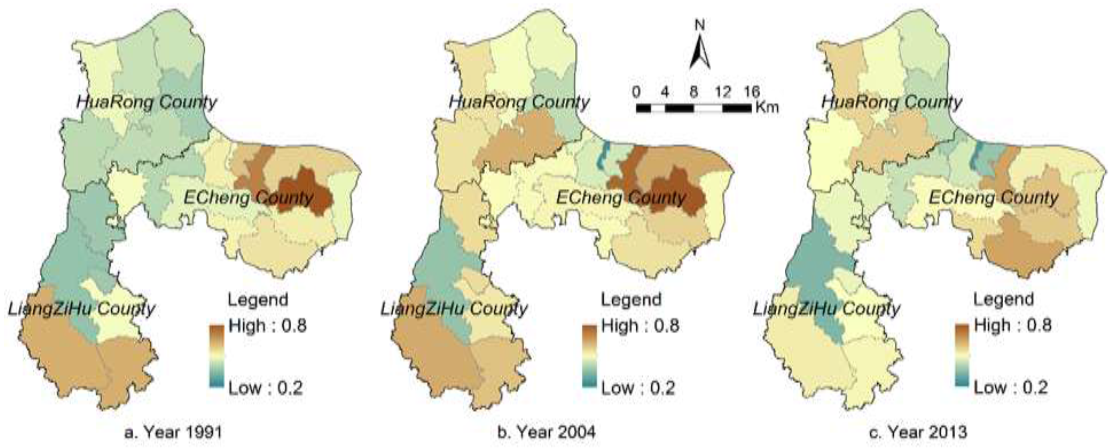
Most towns in the study region in 1991 are at the medium level of ecological risks (see
Figure 8). Ecological risks of the eastern and southern parts of the study region are relatively high (close to 0.8). In 2004, ecological risks at the town level tend to increase (in particular, in the middle and north). In 2013, the eastern part of the study region experienced an increase in ecological risk, but in its mountainous area, ecological risk exhibits a decreasing pattern. In the Liangzi Lake region (also see
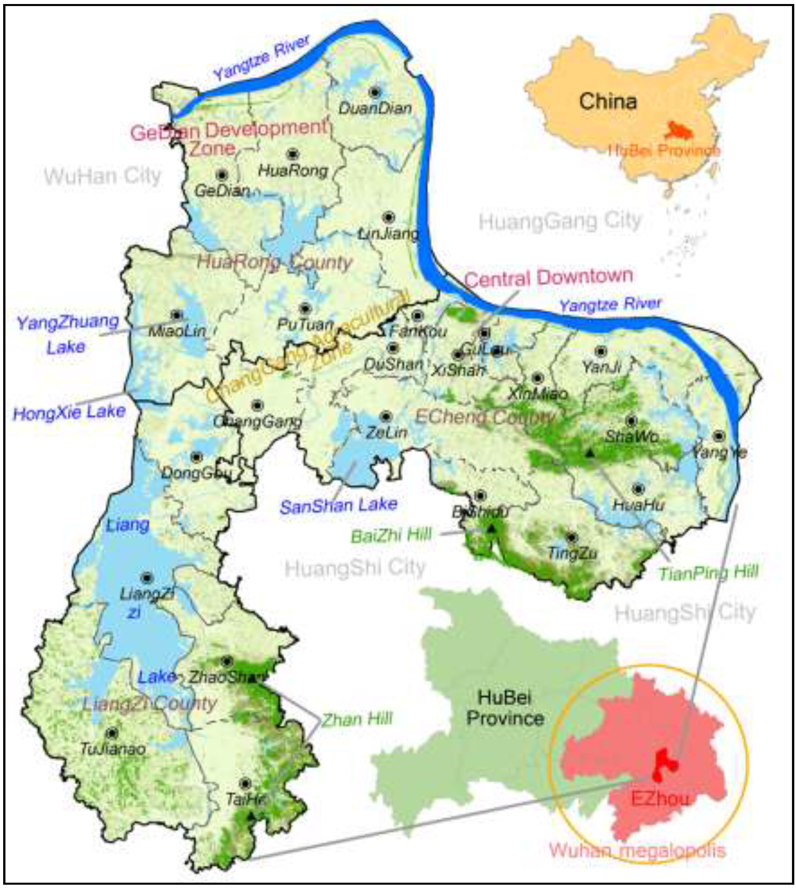
Figure 1), ecological risks decrease substantially due to the establishment of a national-level ecologically representative region. Ecological risks in the Gedian Economic Zone and central city area increase. In general, from 1991 to 2013, ecological risks show an increasing pattern mainly due to the rapid urbanization process, leading to more landscape disturbance in our study region.
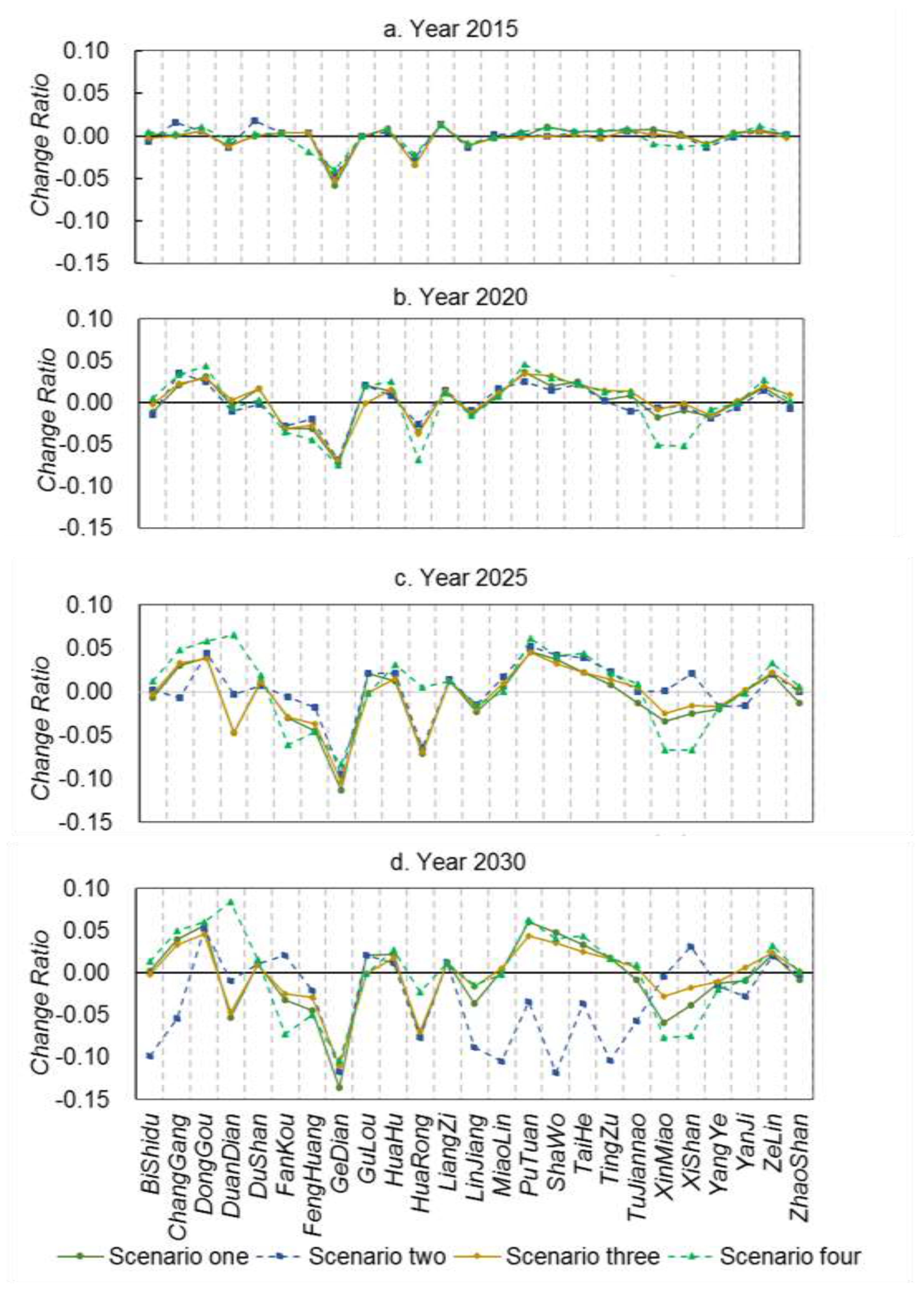
For the four scenarios, averaged town-level landscape ecological risks of our study region remain at a medium level (0.46–0.49) from 2015 to 2030. The landscape fragmentation index shows different patterns across scenarios. From 2015 to 2030, landscape fragmentation due to the protection policies of farmland or forests tends to be high at the early stage (patch density is 4.33 for Scenario 3 in 2015 and 3.80 for scenario 2 in 2020); the impact of landscape fragmentation due to the policy of urban planning tends to be high after 2025 (patch density is 3.71 and 3.56 for Scenario 4 in 2025 and 2030). At the level of land cover type, landscape fragmentation and splitting index for farmlands are the lowest in Scenario 2, yet these indices for built-up lands are higher than those in other scenarios. This shows that due to a strict farmland protection policy, urban development on those farmlands close to existing built-up lands are limited. In Scenario 3, due to the protection of forests and small change in spatial distribution of forested lands, landscape patterns of forest remain relatively stable. However, in Scenario 2, to ensure no decrease in the amounts of farmlands, conversion between forests and farmlands tends to be intensive, i.e., an increase in conversion from forests and other lands to farmland, and an increase in converting low-quality farmland to forests. As a result, this leads to the clustering of forests, in line with the policy of forest conservation. Among these scenarios, landscape patterns of regular water bodies do not exhibit a substantial change. Landscape fragmentation for aquaculture water bodies tends to decrease but the splitting index shows an increasing pattern over time.
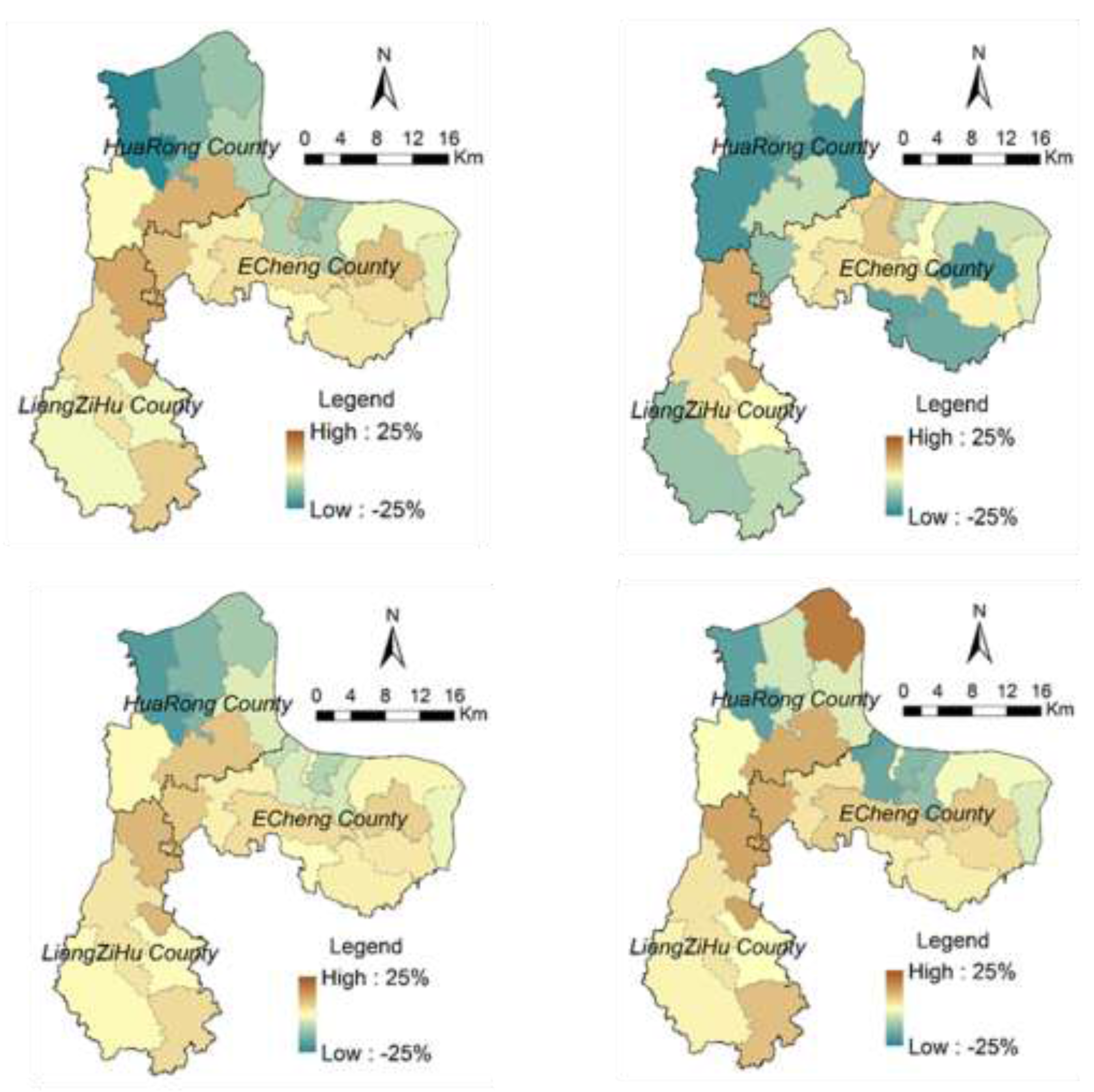
For towns of Gedian and Huarong (northwestern region; also see
Figure 1), ecological risks show decreasing patterns over time, which can be attributed to continual increase in built-up lands under the influence of Wuhan Donghu High Tech Development Zone. For those towns rich in forests and water resources, landscape ecological risks tend to increase first then decrease (see
Figure 10). This is because aquaculture water bodies and forests tend to be converted into farmlands, leading to an increase in landscape fragmentation. Yet, when farmlands become dominated, landscape fragmentation index and splitting index tend to decrease, which explains decrement in ecological risks. However, ecological risks in these towns in Scenario 3 exhibit an increasing pattern. This can be attributed to the conversion of forests and aquaculture water bodies (in second-level conservation zones) into farmlands, leading to increased landscape fragmentation.


