Empirical Retrieval of Surface Melt Magnitude from Coupled MODIS Optical and Thermal Measurements over the Greenland Ice Sheet during the 2001 Ablation Season

Abstract
:1. Introduction
2. Background
2.1. Optical and Thermal Radiative Theory
3. Methods
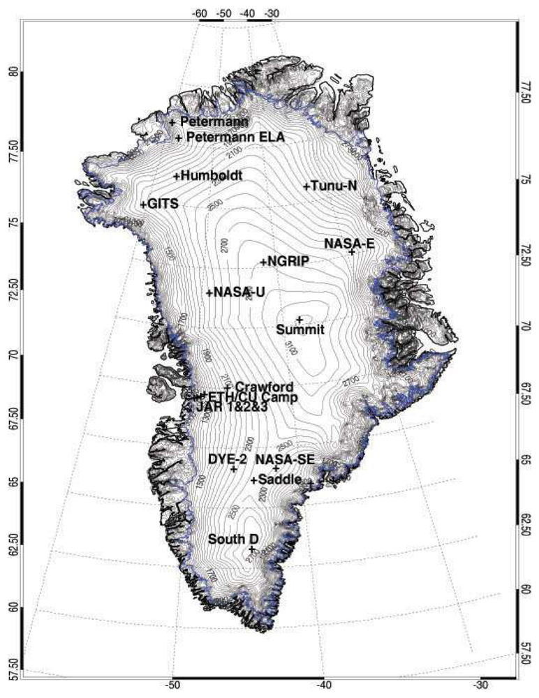
3.1 Data
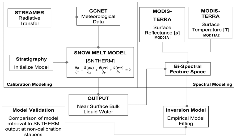
3.2 Model Development Scheme
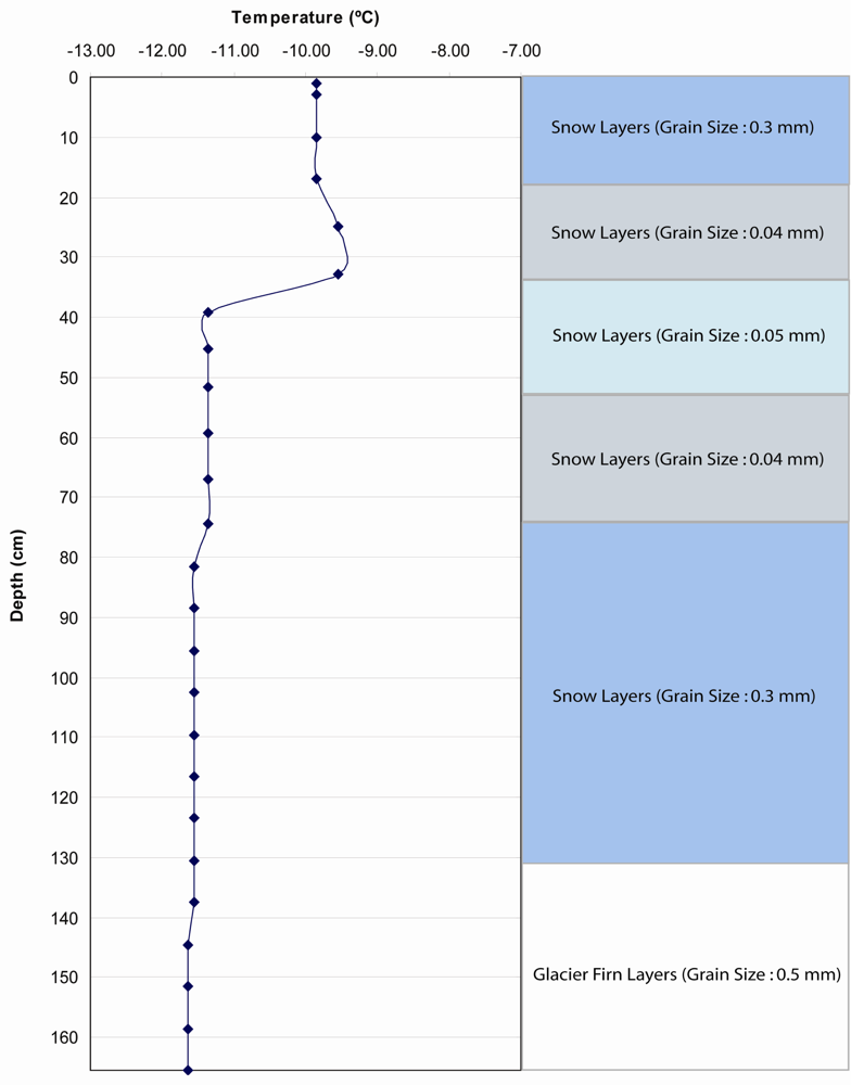
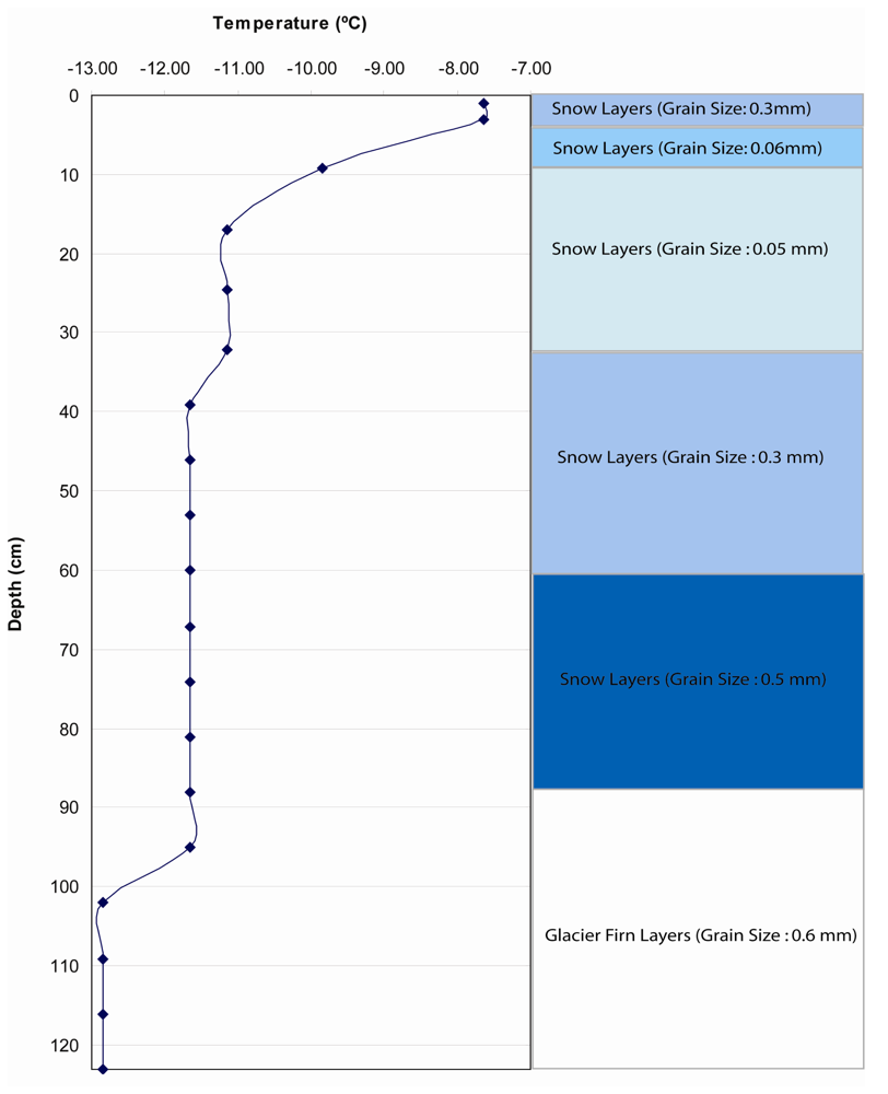
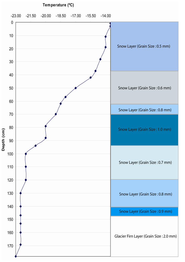
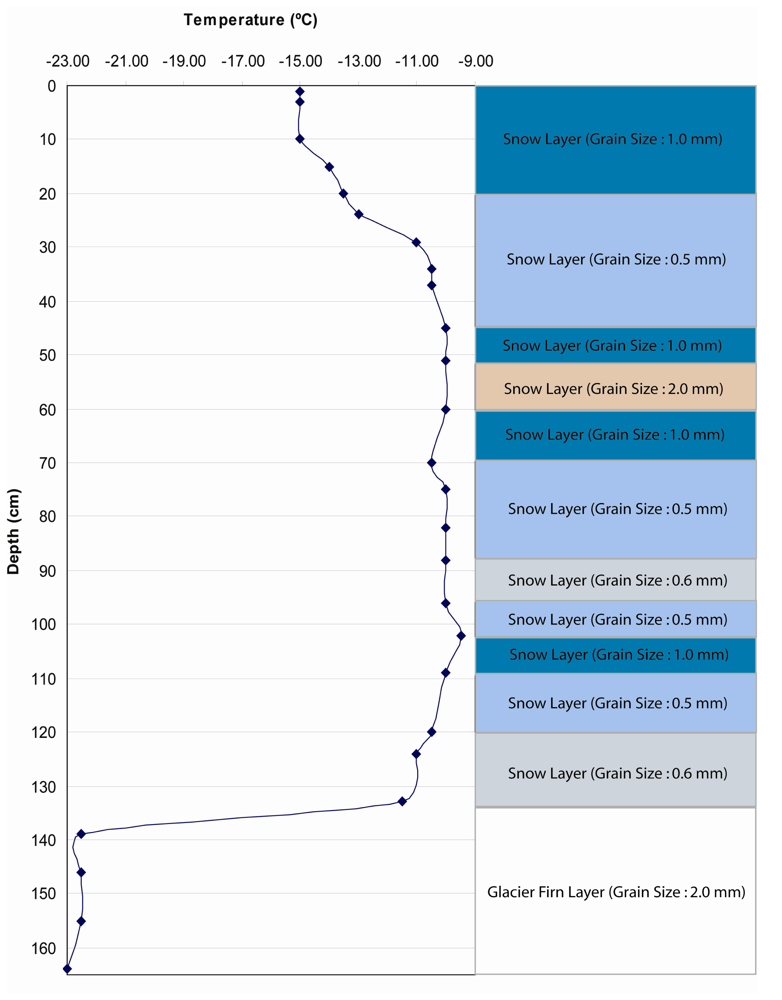
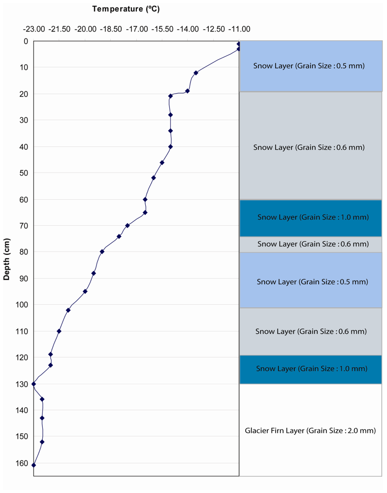
3.3 Sensitivity of SNTHERM89 to Initial Conditions
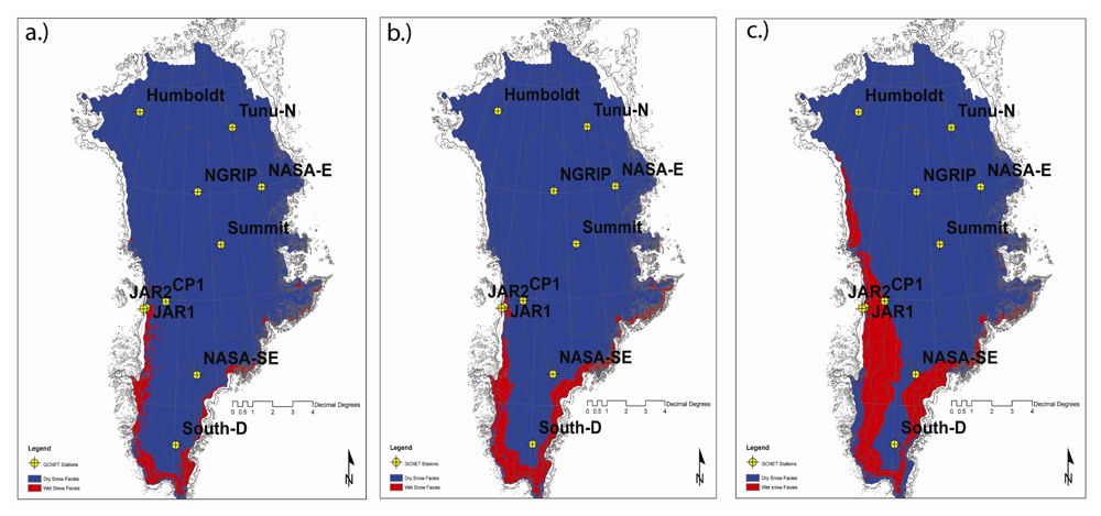
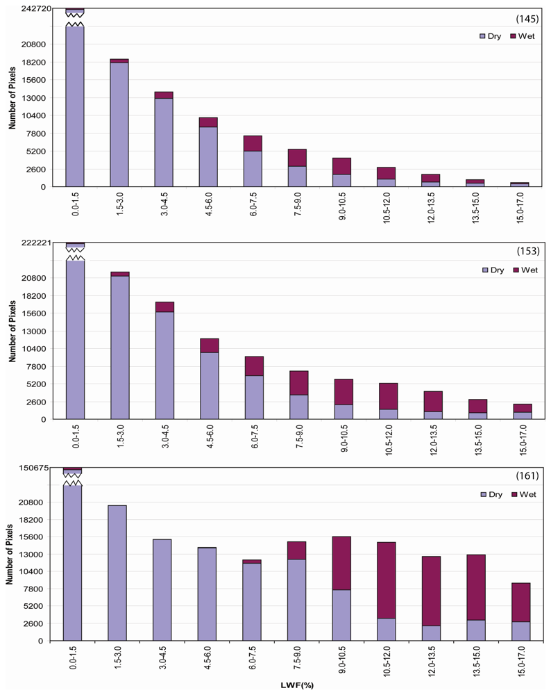
4. Results
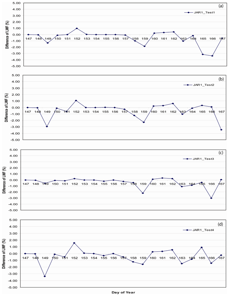
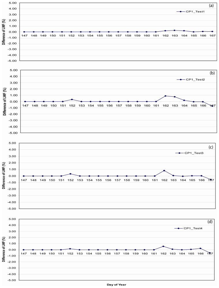
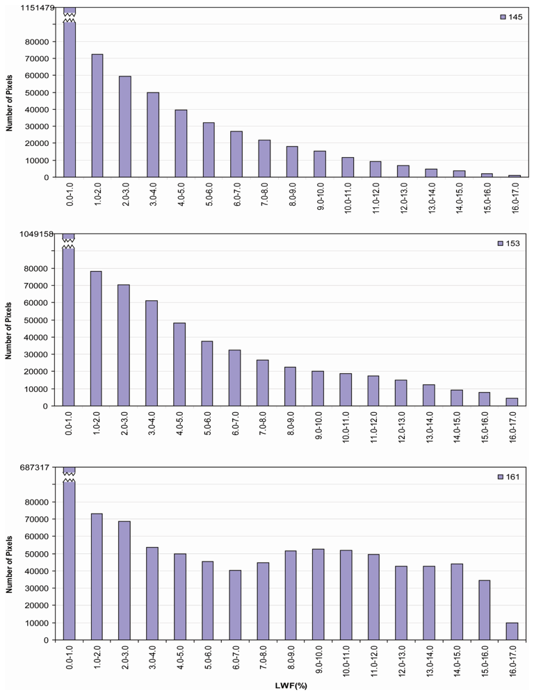
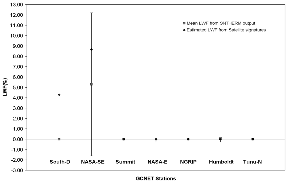
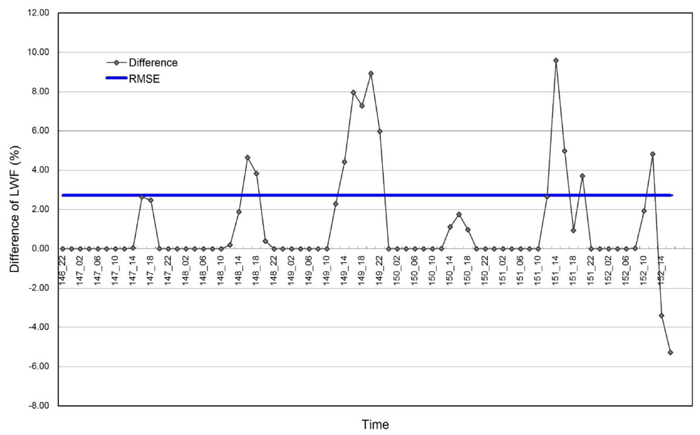
4.1 E-melt Model Validation and Sensitivity
5. Discussion and Conclusion
Acknowledgments
References and Notes
- Abdalati, W.; Steffen, K. Passive microwave-derived snow melt regions on the Greenland Ice Sheet. Geophys. Res. Lett. 1995, 22, 787–790. [Google Scholar]
- Abdalati, W.; Steffen, K. Snowmelt on the Greenland ice sheet as derived from passive microwave satellite data. J. Clim. 1997, 10, 165–175. [Google Scholar]
- Ashcraft, I.; D. Long, D. Increasing temporal resolution in Greenland ablation estimation using passive and active microwave data. Proceedings of the IEEE International Geoscience and Remote Sensing Symposium (IGARSS), Toulouse, France, July 2003; pp. 1604–1606.
- Ashcraft, I.; Long, D. Differentiation between melt and freeze stages of the melt cycle using SSM/I channel ratios. IEEE Trans. Geosci. Remote Sens. 2005, 43, 1317–1323. [Google Scholar]
- Ashcraft, I.; Long, D. Comparison of methods for melt detection over Greenland using active and passive microwave measurements. Int. J. Remote Sens. 2006, 27, 2469–2488. [Google Scholar]
- Baumgartner, F.; Jezek, K.; Forster, R.; Gogineni, S.; Zabel, I. Spectral and angular ground-based radar backscatter measurements of Greenland snow facies. proceedings of the International Geoscience and Remote Sensing Symposium (IGARSS), Hamburg,Germany, August 1999; pp. 1053–1055.
- Benson, C. S. Stratigraphic Studies in snow and firn of the Greenland Ice Sheet. U. S. Army cold regions research and engineering laboratory (CRREL) research report no. 70 1962, 120. [Google Scholar]
- Bindschadler, R. Monitoring ice sheet behavior from space. Rev. Geophys. 1998, 36, 79–104. [Google Scholar]
- Bohren, C. Applicability of effective-medium theories to problems of scattering and absorption by nonhomogeneous atmospheric particles. J. Atmos. Sci. 1986, 43, 468–475. [Google Scholar]
- Bohren, C.; Barkstrom, B. Theory of the optical properties of snow. J. Geophys. Res. 1974, 79, 4527–4535. [Google Scholar]
- Box, J. Polar Day Effective Cloud opacity in the Arctic from measured and modeled solar radiation fluxes. M.A. thesis, Department of Geography, University of Colorado, Boulder, CO, Cooperative Institute for Research in Environmental Sciences. 1997. [Google Scholar]
- Campbell, J. Introduction to Remote Sensing, 4th ed.; New York; Guilford Press, 2007; p. 256. [Google Scholar]
- Chang, A.; Gloersen, A.P.; Schmugge, T.; Wilheit, T.; Zwally, H. Microwave emission from snow and glacier ice. J. Glaciol. 1976, 16, 23–29. [Google Scholar]
- Colbeck, S. Snow-crystal growth with varying surface temperatures and radiation penetration. J. Glaciol. 1989, 35, 23–29. [Google Scholar]
- Colbeck, S. The geometry and permittivity of snow at high frequencies. J. Appl. Phys. 1982, 53, 4495–4500. [Google Scholar]
- Comiso, J.; Yang, J.; Honjo, S.; Krishfield, R.A. Detection of change in the Arctic using satellite and in situ data. J. Geophys. Res. 2003, 108(C12), 3384. [Google Scholar] [CrossRef]
- Cryosphere Theme Report. Integrated Global Observing Strategy (IGOS) 2007, 45.
- Cumming, W. The dielectric properties of ice and snow at 3.2 centimeters. J. Appl. Phys 1952, 23, 768–773. [Google Scholar]
- Dowdeswell, J. The Greenland Ice Sheet and global sea-level rise. Science 2006, 311, 963–964. [Google Scholar]
- Dozier, J. Spectral signature of alpine snow cover from the Landsat Thematic Mapper. Remote Sens. Environ. 1989, 28, 9–22. [Google Scholar]
- Dozier, J.; Warren, S. Effect of view angle on the infrared brightness temperature of snow. Water Resour.Res. 982, 18, 1424–1434. [Google Scholar]
- Fahnestock, M.; Bindschadler, R.; Kwok, R.; Jezek, K. Greenland Ice Sheet surface properties and ice dynamics from ERS-1 SAR imagery. Science. 1993, 262, 1530–1534. [Google Scholar]
- Grenfell, T.; Perovich, D.; Ogren, J. Spectral albedo of an alpine snowpack. Cold Reg. Sci. Technol. 1981, 4, 121–127. [Google Scholar]
- Grenfell, T.; Maykut, G. The optical properties of ice and snow in the arctic basin. J. Glaciol. 1977, 18, 445–463. [Google Scholar]
- Haefliger, M.; Steffen, K.; Fowler, C. AVHRR surface temperature and narrow-band albedo comparison with ground measurements for the Greenland Ice Sheet. Ann. Glaciol. 1993, 17, 49–54. [Google Scholar]
- Hall, D.; Bindschadler, R.; Foster, J.; Chang, A.; Siddalingaiah, H. Comparison of in situ and satellite-derived reflectance of Forbindels Glacier, Greenland. Int. J. Remote Sens. 1990, 11, 493–504. [Google Scholar]
- Hall, D.; Williams, R.S., Jr.; Steffen, K.; Chien, J. Analysis of summer 2002 melt extent on the Greenland Ice Sheet using MODIS and SSM/I data. proceedings of the International Geoscience and Remote Sensing Symposium (IGARSS), Anchorage, Alaska; 2004; pp. 3029–3032. [Google Scholar]
- Hall, D.K.; Williams, R.S., Jr.; Casey, K.A.; DiGirolamo, N.E.; Wan, Z. Satellite-derived, melt-season surface temperature of the Greenland Ice Sheet (2000-2005) and its relationship to mass balance. Geophys. Res. Lett. 2006, 33, L11501, doi:10.1029/2006GL026444. [Google Scholar]
- Hall, D.K.; Williams, R.S., Jr.; Luthcke, S.B.; DiGirolamo, N.E. Greenland Ice Sheet surface-temperature, melt and mass loss: 2000 – 2006. Journal of Glaciol. 2008, 54(184), 81–93. [Google Scholar]
- Hallikainen, M.; Ulaby, F.; Abdelrazik, M. Dielectric properties of snow in the 3 to 37 GHz range. IEEE Trans. Antennas Propag. 1986, 34, 1329–1340. [Google Scholar]
- Jezek, K.; Gogineni, P.; Shanableh, M. Radar measurements of melt zones on the Greenland Ice Shee. Geophys. Res. Lett. 1994, 21, 33–36. [Google Scholar]
- Jordan, R. A one-dimensional temperature model for snow cover, Technical Documentation for SNTHERM89; 1991. [Google Scholar]
- Key, J.; Schweiger, A.J. Tools for atmospheric radiative transfer: Streamer and FluxNet. Comput. Geosci. 1998, 24(5), 443–451. [Google Scholar]
- Key, J.; Haefliger, M. Arctic ice surface temperature retrieval from AVHRR thermal channels. J. Geophys. Res. 1992, 97(D5), 5885–5893. [Google Scholar]
- Klein, A.; Stroeve, J. Development and validation of a snow albedo algorithm for the MODIS Instrument. Ann. Glaciol. 2002, 34, 45–52. [Google Scholar]
- Krabill, W.; Abdalati, W.; Frederick, E.; Manizade, S.; Martin, C.; Sonntag, J.; Swift, R.; Thomas, R.; Wright, W.; Yungel, J. Greenland Ice Sheet: high-elevation balance and peripheral thinning. Science. 2000, 289, 428–430. [Google Scholar]
- Lampkin, D.; Yool, S. Numerical simulations of MODIS sensitivity potential for assessing near surface mountain snow melt. Geocarto International. 2004a, 19, 13–24. [Google Scholar]
- Lampkin, D.; Yool, S. Monitoring mountain snowpack evolution using near-surface optical and thermal properties. Hydrol. Processes. 2004b, 18, 3527–3542. [Google Scholar]
- Liang, S.; Fang, H.; Chen, M.; Shuey, C.J.; Walthall, C.; Daughtry, C.; Morisette, J.; Schaaf, C.; Strahler, A. Validating MODIS land surface reflectance and albedo products: methods and preliminary results. Remote Sens. Environ. 2002, 83, 149–162. [Google Scholar]
- Long, D.; Drinkwater, M. Cryosphere applications of NSCAT data. IEEE Trans. Geosci. Remote Sens. 1999, 37, 1671–1684. [Google Scholar]
- Lubin, D.; Massom, R. Polar Remote Sensing, Volume 1: Atmosphere and Polar Oceans; Praxis-Springer: Chichester, England, and Berlin, Germany, 2006; p. 756. [Google Scholar]
- Marks, D.; Dozier, J. Climate and energy exchange at the snow surface in the alpine region of the Sierra Nevada, 2. Snow cover energy balance. Water Resour. Res. 1992, 28, 3043–3054. [Google Scholar]
- Matzler, C.; Aebischer, H.; Schanda, E. Microwave dielectric properties of surface snow. IEEE J. Oceanic Eng. 1984, OE-9, 366–371. [Google Scholar]
- Mote, T.; Anderson, M. Variations in snowpack melt on the Greenland Ice Sheet based on passive microwave-measurements. J. Glaciol. 1995, 41, 51–60. [Google Scholar]
- Nghiem, S.; Steffen, K.; Kwok, R.; Tsai, W. Detection of snowmelt regions on the Greenland Ice Sheet using diurnal backscatter change. J. Glaciol. 2001, 47, 539–547. [Google Scholar]
- Nolin, A.; Dozier, J. A hyperspectral method for remote sensing of grain size of snow. Remote Sens. Environ. 2000, 74, 207–216. [Google Scholar]
- Painter, T.; Dozier, J.; Roberts, D.; Davis, R.; Green, R. Retrieval of subpixel snow-covered area and grain size from imaging spectrometer data. Remote Sens. Environ. 2003, 85, 64–77. [Google Scholar]
- Peng, R. Estimation of surface melt intensity using optical and thermal measurements over the Greenland Ice Sheet. M.S. thesis, Department of Geography, Pennsylvania State University, 2007. [Google Scholar]
- Ramage, J.; Isacks, B. Determination of melt-onset and refreeze timing on southeast Alaskan icefields using SSM/I diurnal amplitude variations. Ann. Glaciol. 2002, 34, 391–398. [Google Scholar]
- Rees, W. Remote Sensing of Snow and Ice; CRC Press, 2006; pp. 109–118. [Google Scholar]
- Ridley, J. Surface Melting on Antarctic Peninsula Ice Shelves Detected by Passive Microwave Sensors. Geophys. Res. Lett. 1993, 20, 2639–2642. [Google Scholar]
- Rignot, E.; Kanagaratnam, P. Changes in the Velocity Structure of the Greenland Ice Sheet. Science 2006, 311, 986–990. [Google Scholar]
- Rignot, E.; Thomas, R. Mass Balance of Polar Ice Sheets. Science. 2002, 297, 1502–1506. [Google Scholar]
- Shepherd, A.; Wingham, D. Recent Sea-Level Contributions of the Antarctic and Greenland Ice Sheets. Science. 2007, 315, 1529–1532. [Google Scholar]
- Steffen, K.; Box, J. Surface Climatology of the Greenland Ice Sheet: Greenland Climate Network 1995-1999. J. Geophys. Res. 2001, 106, 33951–33964. [Google Scholar]
- Steffen, K.; Abdalati, W.; Stroeve, J. Climate Sensitivity Studies of the Greenland Ice Sheet using Satellite AVHRR, SMMR, SSM/I and in situ Data. Meteorol. Atmos. Phys. 1993, 51, 239–258. [Google Scholar]
- Stroeve, J.; Nolin, A. Comparison of MODIS and MISR-derived Surface Albedo with in situ Measurement in Greenland. Proceedings of EARSeL-LISSIG-Workshop Observing our Cryosphere from Space, Bern, Switzerland; 2002a; pp. 89–96. [Google Scholar]
- Stroeve, J.; Nolin, A. New methods to infer snow from the MISR instrument with applications to the Greenland ice sheet. IEEE Trans. Geosci. Remote Sens. 2002b, 40, 1616–1625. [Google Scholar]
- Stroeve, J.; Nolin, A.; Steffen, K. Comparison of AVHRR-derived and in situ Surface Albedo over the Greenland Ice Sheet. Remote Sens. Environ. 1997, 62, 262–276. [Google Scholar]
- Stroeve, J.; Box, J.; Gao, F.; Liang, S.; Nolin, A.; Schaaf, C. Accuracy Assessment of the MODIS 16-day Albedo Product for Snow: Comparisons with Greenland in situ Measurements. Remote Sens. Environ. 2004, 94, 46–60. [Google Scholar]
- Tedesco, M. Snowmelt Detection over the Greenland Ice Sheet from SSM/I Brightness Temperature Daily Variations. Geophys. Res. Lett. 2007, 34, L02504. [Google Scholar]
- Tiuri, M.; Sihvola, A.; Nyfors, E.; Hallikaiken, M. The Complex Dielectric Constant of Snow at Microwave Frequencies. IEEE J. Oceanic Eng. 1984, OE-9, 377–382. [Google Scholar]
- Veenhuis, B.A. Variability in Surface Reflectance of the Greenland Ice Sheet (1982-2005) using Satellite Remote Sensing. senior thesis, Ohio State University, 2006. [Google Scholar]
- Vermote, E.; El Saleous, N.Z.; Justice, C.O. Atmospheric Correction of MODIS Data in the Visible to Middle Infrared: First Results. Remote Sens. Environ. 2002, 97–111. [Google Scholar]
- Wan, Z.; Zhang, Y.; Zhang, Q.; Li, Z.L. Validation of the Land-Surface Temperature Products Retrieved from Terra Moderate Resolution Imaging Spectroradiometer Data. Remote Sens. Environ. 2002, 83, 63–180. [Google Scholar]
- Warren, S. Optical properties of snow. Rev. Geophys. Space Phys. 1982, 20, 67–89. [Google Scholar]
- Warren, S.; Wiscombe, W. A Model for the Spectral Albedo of Snow II: Snow Containing Atmospheric Aerosols. J. Atmos. Sci. 1981, 37, 2734–2745. [Google Scholar]
- Wiscombe, W.; Warren, S. A Model for the Spectral Albedo of Snow I: Pure Snow. J. Atmos. Sci. 1981, 37, 2712–2733. [Google Scholar]
- Wismann, V. Monitoring of Seasonal Snowmelt on Greenland with ERS Scatterometer Data. IEEE Trans. Geosci. Remote Sens. 2000, 38, 1821–1826. [Google Scholar]
- Zhou, X.; Li, S.; Stamnes, K. Effects of Vertical Inhomogeneity on Snow Spectral Albedo and its Implication for Optical Remote Sensing of Snow. J. Geophys. Res. 2003, 108. NO. D23. [Google Scholar]
- Zwally, H.; Fiegles, S. Extent and Duration of Antarctic Surface Melt. J. Glaciol. 1994, 40, 463–476. [Google Scholar]
- Zwally, H.; Abdalati, W.; Herring, T.; Larson, K.; Saba, J.; Steffen, K. Surface Melt-Induced Acceleration of Greenland Ice Sheet Flow. Science. 2002, 297, 218–222. [Google Scholar]


| Parameter | Instrument | Instrument Accuracy | Sample Interval |
|---|---|---|---|
| Air temperature | Vaisala CS-500 | 0.1°C | 60 s*, 15 s |
| Air temperature | Type-E Thermocouple | 0.1°C | 60 s*, 5 s |
| Relative humidity | Vaisala Intercap | 5%<90%, 10%>90% | 60 s |
| Wind speed * | RM Young Propeller-type Vane | 0.1m s-1 | 60 s*, 15 s |
| Wind direction | RM Young | 5° | 60 s |
| Station pressure | Vaisala PTB 101B | 0.1mb | 60 min |
| Surface height change | Campbell SR-50 | 1mm | 10 min |
| Shortwave radiation | Li Core SI Photodiode | 5-15% | 15 s |
| Net radiation | REBS Q7 | 5-50% | 15 s |
| Snow temperature | Type-T Thermocouple | 0.1° | 15 s |
| Data logger | Campbell Scientific 10X | ||
| Multiplexer | Campbell Scientific Am25T | ||
| GPS | Garmin | 1s | 1day |
| Solar panel | Campbell Scientific 20 w |
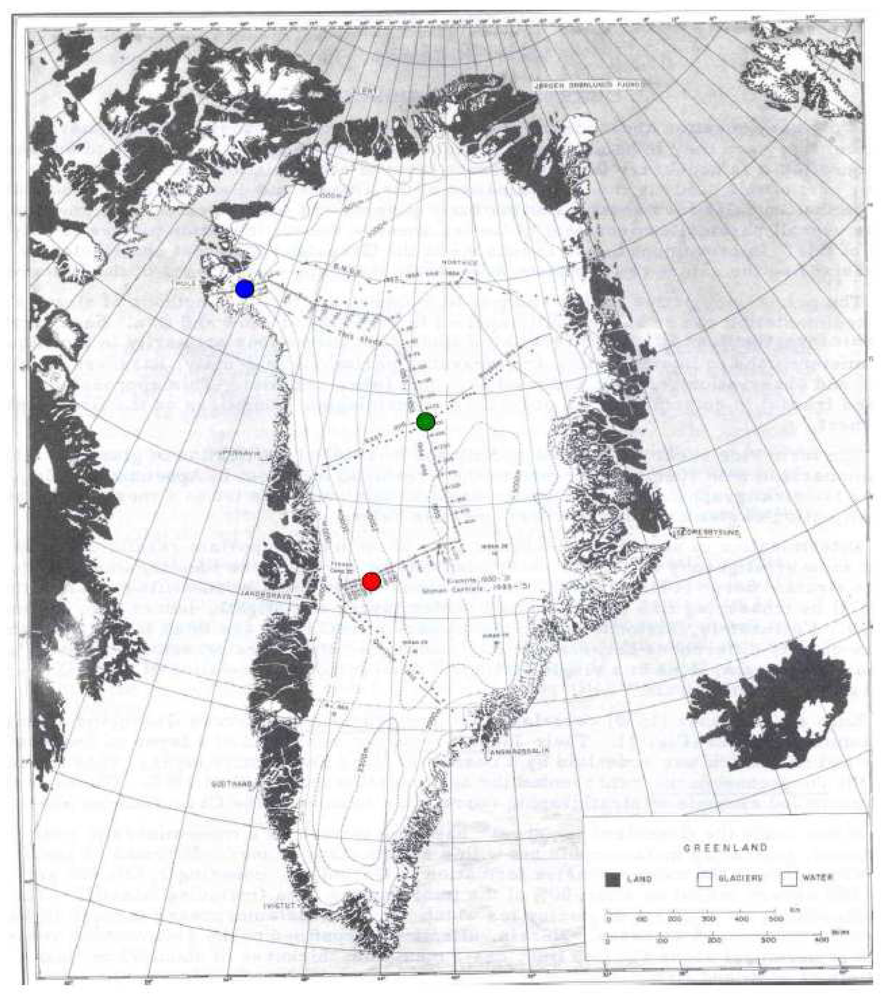
| Station Name | Latitude and Longitude | Altitude (m) |
|---|---|---|
| Crawford Point 1 | 69.8819N, 46.9736W | 2022 |
| JAR1 | 69.4984N, 49.6816W | 962 |
| JAR2 | 69.4200N, 50.0575W | 568 |
| Reflectance | Temperature (K) | Liquid Water Fraction (%) |
|---|---|---|
| 0.5887 | 263.02 | 0.32 |
| 0.4681 | 260.80 | 0.00 |
| 0.2987 | 268.06 | 7.39 |
| 0.3665 | 267.48 | 5.51 |
| 0.3763 | 268.74 | 3.94 |
| 0.1492 | 271.76 | 14.28 |
| 0.2325 | 271.90 | 16.14 |
| 0.3029 | 271.50 | 15.65 |
| 0.1157 | 272.52 | 16.42 |
| Model | Dependent Variable | Independent Variable | Coefficient of Reflectance | Coefficient of Temperature | Constant |
|---|---|---|---|---|---|
| I | <LWF> | Reflectance, Temperature | -0.136 | 0.011 | -2.822 |
| Strata | Description | Mean Temperature (°K) | Mean Density (kg/m3) | Mean Grain Size (m) |
|---|---|---|---|---|
| Swiss Camp (SC) | Stratigraphy excavated at Swiss Camp on May 16, 2001 at an elevation of 1149 m | 263.3 | 174.3 | 0.0003 |
| Test 1 | Fabricated strata with fewer layers, higher temp gradient and larger change in grain size near surface than Swiss Camp stratigraphy | 264.8 | 107.0 | 0.0002 |
| Test 2* | Low temperatures, greater range in grain size at depth, and higher densities near top and lower near bottom relative to SC from firn at lower elevation (∼1000m) near the north-eastern coast | 259.3 | 250 | 0.0005 |
| Test 3* | Inverted near surface gradient, similar density profile as Test 2, most stratified and derived from firn in the percolation zone (∼2200m) | 258.0 | 250.0 | 0.001 |
| Test 4* | A near linear temperature gradient, derived from firn in the accumulation zone of the ice sheet at an elevation of ∼2800 m | 261.2 | 263.3 | 0.0005 |
| Station Name | Latitude and Longitude | Elevation (m) |
|---|---|---|
| Humboldt Gl. | 78.5266N, 56.8305W | 1995 |
| Summit | 72.5794N, 38.5042W | 3208 |
| Tunu-N | 78.0168N, 33.9939W | 2020 |
| NASA-E | 75.0000N, 29.9997W | 2631 |
| NGRIP | 75.0998N, 42.3326W | 2950 |
| South-D | 63.1489N, 44.8167W | 2922 |
| NASA-SE | 66.4797N, 42.5002W | 2579 |
© 2008 by the authors; licensee Molecular Diversity Preservation International, Basel, Switzerland. This article is an open-access article distributed under the terms and conditions of the Creative Commons Attribution license ( http://creativecommons.org/licenses/by/3.0/).
Share and Cite
Lampkin, D.; Peng, R. Empirical Retrieval of Surface Melt Magnitude from Coupled MODIS Optical and Thermal Measurements over the Greenland Ice Sheet during the 2001 Ablation Season. Sensors 2008, 8, 4915-4947. https://doi.org/10.3390/s8084915
Lampkin D, Peng R. Empirical Retrieval of Surface Melt Magnitude from Coupled MODIS Optical and Thermal Measurements over the Greenland Ice Sheet during the 2001 Ablation Season. Sensors. 2008; 8(8):4915-4947. https://doi.org/10.3390/s8084915
Chicago/Turabian StyleLampkin, Derrick, and Rui Peng. 2008. "Empirical Retrieval of Surface Melt Magnitude from Coupled MODIS Optical and Thermal Measurements over the Greenland Ice Sheet during the 2001 Ablation Season" Sensors 8, no. 8: 4915-4947. https://doi.org/10.3390/s8084915
APA StyleLampkin, D., & Peng, R. (2008). Empirical Retrieval of Surface Melt Magnitude from Coupled MODIS Optical and Thermal Measurements over the Greenland Ice Sheet during the 2001 Ablation Season. Sensors, 8(8), 4915-4947. https://doi.org/10.3390/s8084915