Using the Remote Sensing and GIS Technology for Erosion Risk Mapping of Kartalkaya Dam Watershed in Kahramanmaras, Turkey

Abstract
:1. Introduction
2. Material and Methods
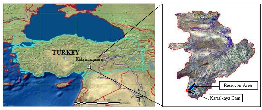
2.1. Study Area
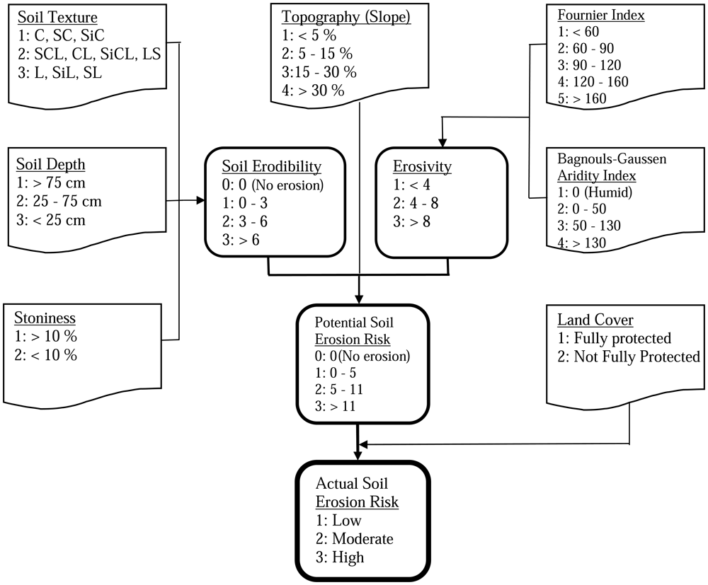
2.2. CORINE Erosion Model
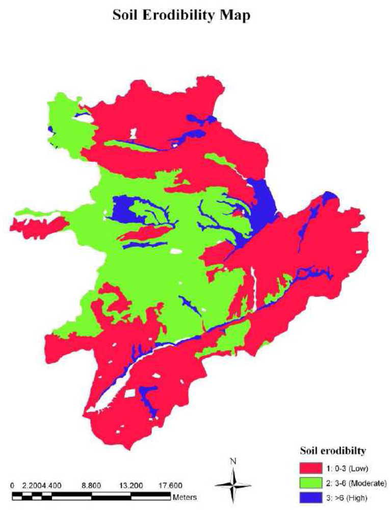
2.2.1. Soil Erodibility
2.2.2. Erosivity
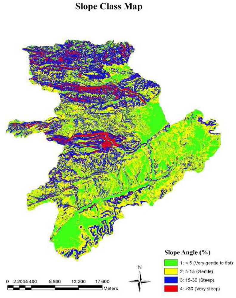
2.2.3. Topography (Slope)
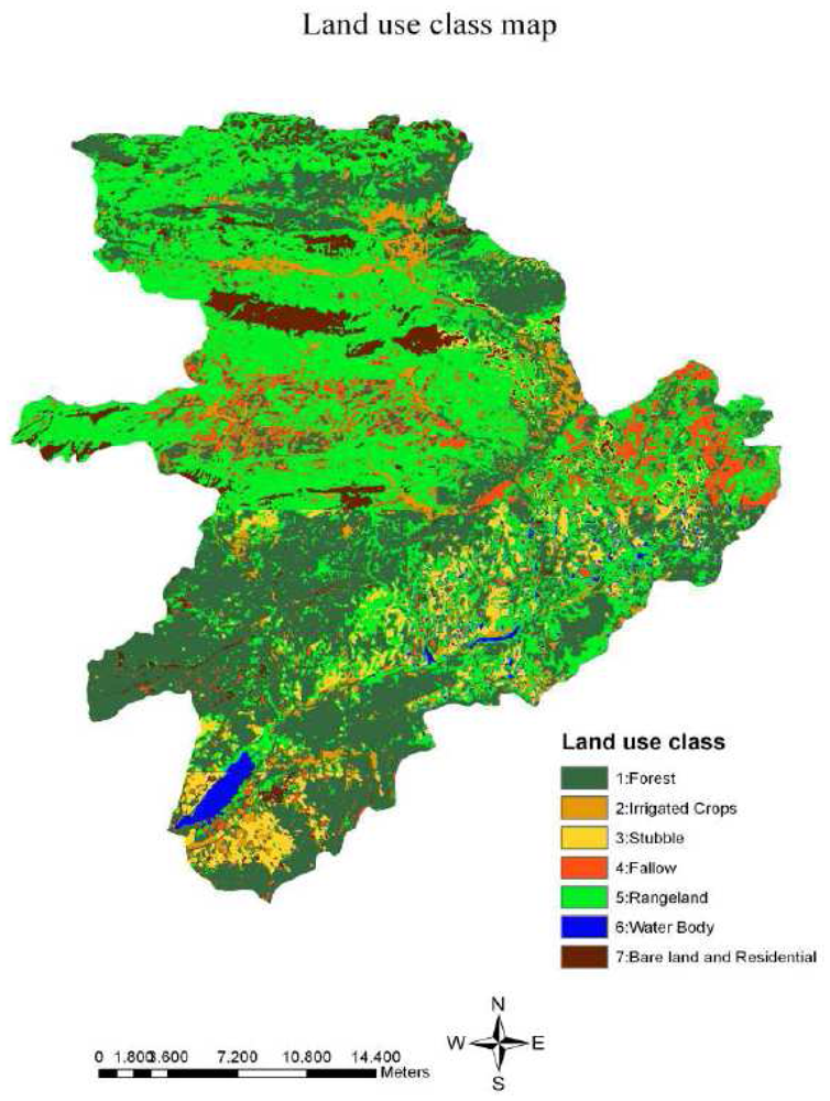
2.2.4. Vegetation Cover
2.2.5. Actual Erosion Risk
3. Results and Discussion
4. Conclusion
Acknowledgments
References
- GDSHW. General Directorate of State Hydraulic Works. http://www.dsi.gov.tr/english/topraksue.htm visited on February 2008.
- Akay, A.E.; Sessions, J. Applying the Decision Support System, TRACER, to Forest Road Design. Western Journal of Applied Forestry 2005, 20(3), 184–191. [Google Scholar]
- Akay, A.E.; Erdas, O.; Reis, M.; Yuksel, A. Estimating sediment yield from a forest road network by using a sediment prediction model and GIS techniques. Building and Environment 2008, 43(5), 687–695. [Google Scholar]
- GDREC. General Directorate of Reforestation and Erosion Control. http://www.agm.gov.tr visited on January 8th, 2008.
- Jinren, R.N.; Yingkui, K.L. Approach to soil erosion assessment in terms of land-use structure changes. Journal of Soil and Water Conservation 2003, 58(3), 158–169. [Google Scholar]
- Lal, R. Soil Erosion Research Method, Second Edition ed; Soil and Water Conservation Society: Ankeny, IA, USA, 1994; p. 352 p. [Google Scholar]
- CORINE. Soil Erosion Risk and Important Land Resources in the Southeastern Regions of the European Community; EUR 13233: Luxembourg, BELGIUM, 1992; pp. 32–48. [Google Scholar]
- Burrough, P.A.; McDonnell, R.A. Principles of Geographic Information Systems; Oxford Science Publications: New York, USA, 1998; p. 356 p. [Google Scholar]
- Yuksel, A.; Akay, A.E.; Gundogan, R. Using ASTER Imagery in Land Use/cover Classification of Eastern Mediterranean Landscapes According to CORINE Land Cover Project. Sensors 2008, 8, 1237–1251. [Google Scholar]
- Rode, M.; Frede, H.G. Modification of AGNPS for agricultural land and climate conditions in central Germany. J. Environ. Qual. 1997, 26, 165–172. [Google Scholar]
- Millward, A.A.; Mersey, J.E. Adapting the RUSLE to model soil erosion potential in a mountainous tropical watershed. Catena 1999, 38, 109–129. [Google Scholar]
- Jong, S.M.; Paracchini, M.L.; Bertolo, F.; Folving, S.; Megier, J. Regional assessment of soil erosion using the distributed model SEMMED and remotely sensed data. Catena. 1999, 37, 291–308. [Google Scholar]
- Yuksel, A.; Akay, A.E.; Gundogan, R.; Reis, M.; Cetiner, M. Application of GeoWEPP for Determining Sediment Yield and Runoff in the Orcan Creek Watershed in Kahramanmaras, Turkey. Sensors 2008, 8, 1222–1236. [Google Scholar]
- Dangerrnond, J. What is a Geographic Information Information Systems (GIS)? Geographic Information Information Systems (GIS) and Mapping- Practices a Standards; Johnson, A.I., Pettersson, C.B., Fulton, J.L., Eds.; American Society for Testing and Materials, 1991; pp. 11–17. [Google Scholar]
- Willmott, C.J. On the validation of models. Physical Geography 1981, 2(2), 184–194. [Google Scholar]
- Okalp, K. Soil erosion risk mapping using geographic information systems: a case study on Kocadere creek watershed, Izmir. MSc Thesis., Department of Geodetic and Geographic Information Technologies, Natural and Applied Sciences of Middle East Technical University, Ankara, Turkey, 2005; pp. 20–21. [Google Scholar]
- Mitasova, H.; Hofierka, J.; Zlocha, M.; Iverson, R.L. Modeling topographic potential for erosion and deposition using GIS. International Journal of Geographical Information Science 1996, 10, 5. 629–641. [Google Scholar]
- Vrieling, A.; Sterk, G.; Beaulieu, N. Erosion risk mapping; a methodological case study in the Colombian Eastern Plains. Journal of Soil and Water Conservation 2002, 57, 3. 158–163. [Google Scholar]
- Sazbo, J.; Pasztor, L.; Suba, Z.; Varallyay, G. Integration of remote sensing and GIS techniques in land degradation mapping. Proceedings of the 16th International Congress of Soil Science, Montpellier, France, August 1998; pp. 63–75.
- Bojie, F.; Xilin, W.; Gulinck, H. Soil erosion types in the Loess Hill and Gully area of China. J. Environ. Sci. Eng. 1995, 7, 266–272. [Google Scholar]
- Renard, K.G.; Foster, G.R.; Weesies, G.A.; McCool, D.K.; Yoder, D.C. Predicting Soil Erosion by Water: A Guide to Conservation Planning with the Revised Universal Soil Loss Equation (RUSLE).; U.S Department of Agriculture, Agricultural Handbook. No 703 Government Printing Office: Washington. DC, USA, 200; p. 384 p. [Google Scholar]
- Flanagan, D.C.; Livingston, S.J. WEPP user summary: USDA-Water Erosion Prediction Project (WEPP).; USDA-ARS National Soil Erosion Research Laboratory, 1995; NSERL Report No. 11. [Google Scholar]
- Wischmeier, W.H. Use and misuse of the universal soil loss equation. Journal of Soil and Water Conservation 1976, 31(1), 5–9. [Google Scholar]
- Kılıc, S.; Evrendılek, F.; Berberoglu, S.; Demırkesen, A.C. Environmental monitoring of land-use and land-cover changes ın a medıterranean region of Turkey. Environmental Monitoring And Assessment 2006, 114, 157–168. [Google Scholar]
- Evrendilek, F.; Berberoglu, S.; Gulbeyaz, O.; Ertekin, C. Modeling Potential Distribution and Carbon Dynamics of Natural Terrestrial Ecosystems: A Case Study of Turkey. Sensors 2007, 7, 2273–2296. [Google Scholar]
- Zhu, G.; Blumberg, D.G. Classification using ASTER data and SVM algorithms; the case study of Beer Sheva, Israel. Remote Sensing Environment 2001, 80, 233–240. [Google Scholar]
- Abrams, M. The Advanced Spaceborne Thermal Emission and Reflection Radiometer (ASTER): data products for the high spatial resolution imager on NASA's Terra platform. International Journal of Remote Sensing 2003, 21(5), 847–859. [Google Scholar]
- TSMS. Kahramanmaras province meteorological data; Turkish State Meteorological Service, 2007; Ankara. [Google Scholar]
- GDSHW. General Diroctorate of State Hydraulic Works. http://www.dsi.gov.tr/baraj/detayeng.cfm BarajID=46 visited on January 2008.
- Soil Survey Division Staff. In Soil Survey Manual.; U.S. Department of Agriculture. Handbook No:18. U.S. Government Printing Office: Washington, DC, USA, 1993; p. 437 p.
- Soil Survey Staff. In Keys to Soil Taxonomy., 8th edn; U.S. Department of Agriculture Natural Resources Conservation Service: Washington, DC, USA, 1998; p. 328 p.
- Dengiz, O.; Akgul, S. Soil erosion risk assessment of the Golbasi environmental protection area and its vicinityusing the CORINE model. Turkish Journal of Agriculture and Forestry 2005, 29, 439–448. [Google Scholar]
- Bayramin, I.; Erpul, G.; Erdogan, H.E. Use of CORINE methodology to asses soil erosion risk in the Semi-Arid area of Beypazarı. Turkish Journal of Agriculture and Forestry 2006, 30, 81–100. [Google Scholar]
- Parlak, M. Determination of erosion risk according to CORINE methodology (a case study:Kurtbogazi Dam). International Congress River Basin Management 2007, 1, 844–859. [Google Scholar]
- GDRS. Soil Survey Report of Kahramanmaraş Province.; Report No: 46; General Directorate of Rural Services: Ankara, Turkish, 1999; p. 105 p. [Google Scholar]
- Burt, R. Soil Survey Laboratory Methods Manual Soil; Survey Investigations Report No. 42. U.S. Department of Agriculture Natural Resources Conservation Service, 2004. http://soils.usda.gov/technical/lmm/.
- Editors of ESRI. Using ArcGIS Spatial Analyst ArcGIS 9; ESRI Inc. Redlands, 2004; p. 233 p. [Google Scholar]
- Fournier, F. Climat et Érosion.; Presses Universitaires de France: Paris, France, 1960; p. 201 p. [Google Scholar]
- Arnolds, H.M. An aproximation of the rainfall factor in the Universal Soil Loss Equation. En. De Boodt, M., Gabriels, D., Eds.; In Assessment of erosion.; John Wiley and Sons, Inc: Chichester, West Sussex, UK, 1980; pp. 127–132. [Google Scholar]
- Oduro-Afriye, K. Rainfall Erosivity Map for Ghana. In Geoderma; Elsevier Science B.V. 1125, 1996; p. 6 p. [Google Scholar]
- Yuksel, A.; Akay, A.E.; Reis, M.; Gundogan, R. Using The WEPP Model To Predict Sediment Yield In A Sample Watershed In Kahramanmaras Region. International Congress River Basin Management 2007, 2, 11–22. [Google Scholar]
- ERDAS. Field Guide; ERDAS Inc.: Atlanta, USA, 1995; p. 655 p. [Google Scholar]
- Akay, A.E.; Karas, I.R.; Gundogan, R. Classification of Tree and Shrub Species in KSU Research and Application Forest In Kahramanmaras, Turkey. In 10th Intl. Symposium on Physical Measurements and Spectral Signatures in Remote Sensing; Schaepman, M.E., Liang, S., Groot, N.E., Kneubühler, M., Eds.; Intl. Archives of the Photogrammetry, Remote Sensing and Spatial Information Sciences; Vol. XXXVI, WG VII/I, ISPRS; Davos, Switzerland, 2007; pp. 334–337. [Google Scholar]


| Class Names | Reference Data | ||||||||
|---|---|---|---|---|---|---|---|---|---|
| Forest | Irrigated Crops | Stubble | Fallow | Range Land | Water Body | Bare Land/Residential | Total | User's Accuracy | |
| Forest | 75 | 10 | 1 | 10 | 6 | 1 | 103 | 72.82 | |
| Irrigated Crops | 15 | 15 | 100.00 | ||||||
| Stubble | 2 | 35 | 5 | 42 | 83.33 | ||||
| Fallow | 3 | 1 | 12 | 3 | 19 | 63.16 | |||
| Range Land | 2 | 3 | 39 | 1 | 45 | 86.67 | |||
| Water Body | 5 | 5 | 100.00 | ||||||
| Bare Land/Residential | 1 | 3 | 1 | 1 | 20 | 26 | 76.92 | ||
| Total | 83 | 26 | 39 | 26 | 49 | 5 | 27 | 256 | |
| Producer's Accuracy | 90.36 | 57.69 | 89.74 | 46.15 | 79.59 | 100.00 | 74.07 | ||
| Index Values | Potential Erosion Risk | Actual Soil Erosion Risk | ||
|---|---|---|---|---|
| Area (ha) | Percentage | Area (ha) | Percentage | |
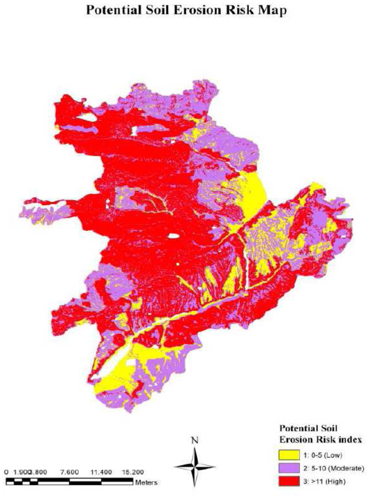
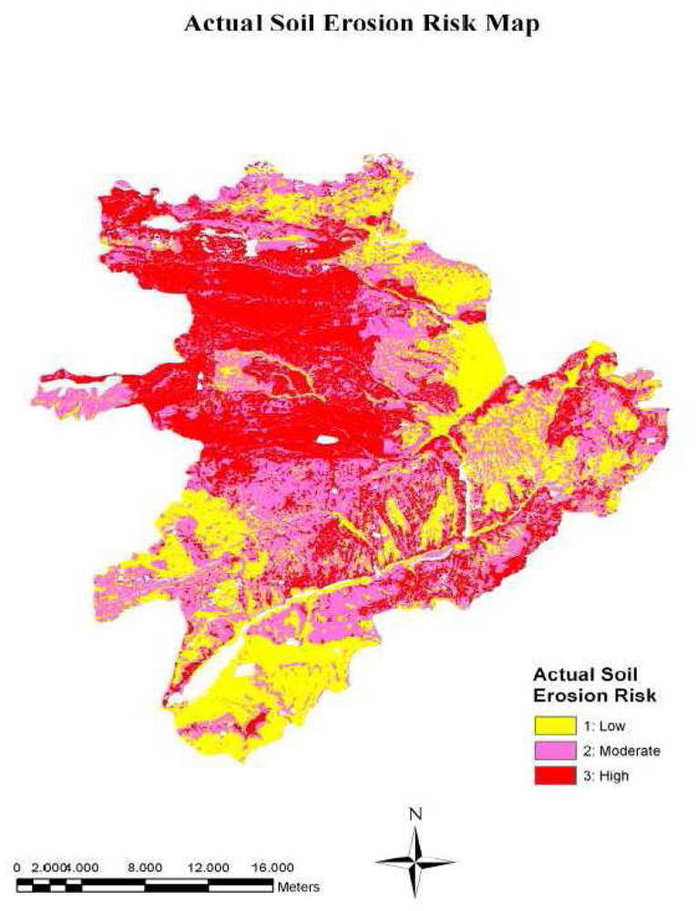
| 1 | 15870 | 18.01 | 29797 | 34 |
| 2 | 30112 | 34.18 | 31221 | 35 |
| 3 | 42120 | 47.81 | 27084 | 31 |
| Total | 88102 | 100.00 | 88102 | 100 |
© 2008 by the authors; licensee Molecular Diversity Preservation International, Basel, Switzerland. This article is an open-access article distributed under the terms and conditions of the Creative Commons Attribution license ( http://creativecommons.org/licenses/by/3.0/).
Share and Cite
Yuksel, A.; Gundogan, R.; Akay, A.E. Using the Remote Sensing and GIS Technology for Erosion Risk Mapping of Kartalkaya Dam Watershed in Kahramanmaras, Turkey. Sensors 2008, 8, 4851-4865. https://doi.org/10.3390/s8084851
Yuksel A, Gundogan R, Akay AE. Using the Remote Sensing and GIS Technology for Erosion Risk Mapping of Kartalkaya Dam Watershed in Kahramanmaras, Turkey. Sensors. 2008; 8(8):4851-4865. https://doi.org/10.3390/s8084851
Chicago/Turabian StyleYuksel, Alaaddin, Recep Gundogan, and Abdullah E. Akay. 2008. "Using the Remote Sensing and GIS Technology for Erosion Risk Mapping of Kartalkaya Dam Watershed in Kahramanmaras, Turkey" Sensors 8, no. 8: 4851-4865. https://doi.org/10.3390/s8084851