1. Introduction
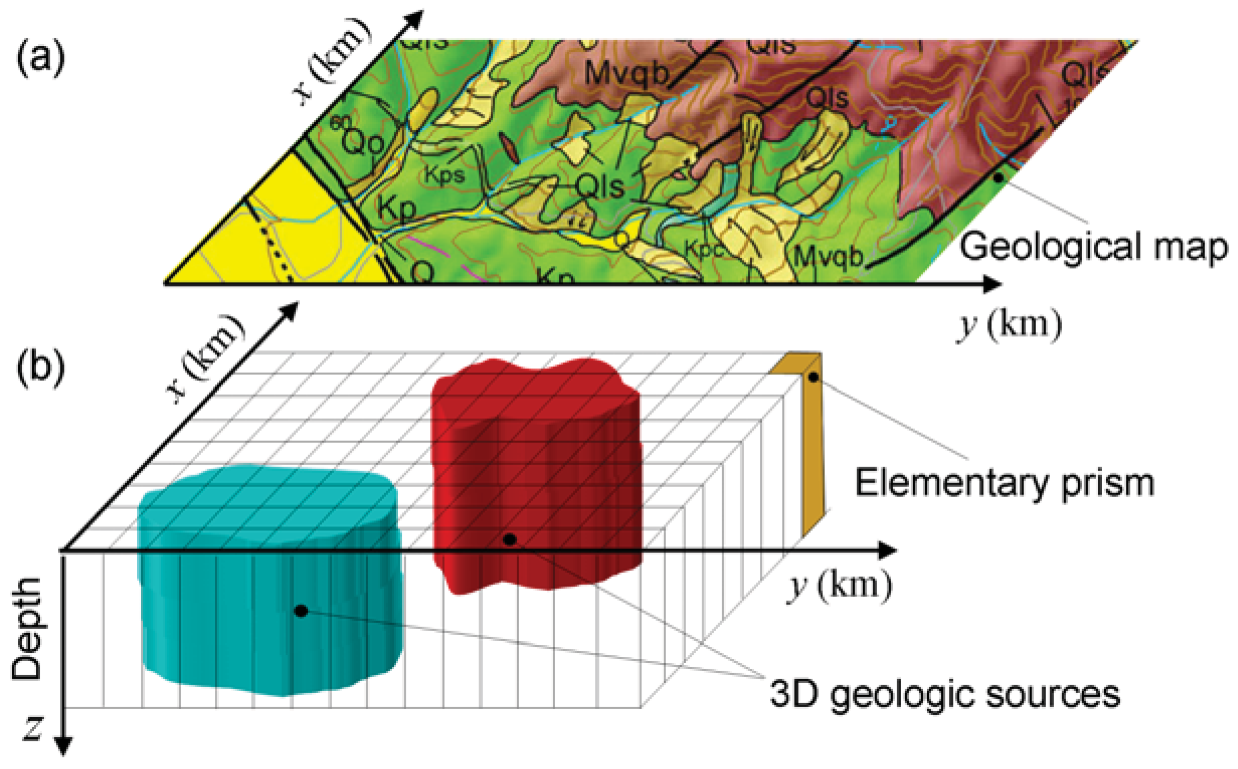
One of geologists’ objectives is to unravel the geologic history through the knowledge of the geologic processes. The evidence necessary to reconstruct the geologic history of a particular region require the production of a geologic map, which consists in identifying and demarcating geologic units. Because geologic mapping helps in understanding the geologic processes, it is used for targeting mineral resources. Hence, the first stage of mineral exploration investigation involves geologic mapping.
To produce a geologic map, geologists combine different types of information such as field, aerial and satellite data. This implies bringing together all geologic data collected mainly at the Earth’s surface to create a geologic map. Usually, the geologic interpretation of these data leads to the identification of lithology, the location of geologic contacts, faults, folds, and other geologic features. However, in the absence of outcrops one must resort to indirect measurements such as the ones provided by geophysics. Gravity and magnetic data are among the most important geophysical data used as a tool in geologic mapping [
1,
2,
3,
4,
5,
6] by allowing the production of magnetization and density contrast maps, respectively, thorough an inversion procedure.
Research efforts in the last decades have developed inversion methods to estimate physical-property contrast distributions (magnetization or density contrast maps) from geophysical data (gravity or magnetic data). Most of these gravity or magnetic inversion methods parameterize the Earth’s subsurface into a grid of cells distributed inside a horizontal slab with known depths to the top and bottom, and estimate the physical-property contrast of each cell element which should retrieve the geologic sources and fit the data. The inverse problem of estimating this discrete density or magnetization contrast distribution from, respectively, the gravity or the magnetic data is an ill-posed problem because its solution is unstable. The standard Tikhonov regularization method [
7] is then generally used to guarantee a stable solution. Mathematically, it consists of formulating a constrained inverse problem, which is solved by the minimization of a function composed by: (1) the data-misfit function that measures a norm of the difference between the observed and predicted data, and (2) the regularizing function defined in the parameter (model) space that imposes physical or geological attributes on a solution. In this way, the solution will be biased by the
a priori information introduced by the regularizing function [
8]. A classical regularizing function used in geophysics, named the first-order Tikhonov regularization, imposes a smooth character on the solution. Mathematically, it is defined as the
norm of the first-order derivatives of the density- or magnetic-contrast distribution along two horizontal directions. In this case, the estimated physical-property distribution will be spatially smooth. This estimated smooth physical-property distribution leads to a blurred geologic map, that is, sharp geologic contacts will be displayed as smooth transitions.
To estimate nonsmooth physical-property contrast distributions through a user-specified grid of cells, we use the gravity or magnetic measurements as geophysical data and the entropic regularization as a stabilizing function that allows estimating sharp discontinuities in the physical-property contrast distribution. The entropic regularization consists in minimizing the first-order entropy measure of the vector containing the physical-property contrast distribution estimated at a discrete grid of cells and simultaneously inhibiting any excessive minimization of the zeroth-order entropy. The latter is a necessary imposition to prevent the collapse of the solution into unrealistic density or magnetic contrast distributions consisting of predominantly null values and a few unrealistically large nonnull values.
The application of the magnetization-contrast mapping, using the entropic and the first-order Tikhonov regularizations, to the magnetic anomaly over Butte Valley, NV, USA, showed an estimated source presenting one of its dimensions much larger than the other. This particular shape (which is different from the usual ring-like shape of most skarns) and the available geological information, allowed to infer that the Butte Valley anomaly is produced by an exoskarn where the ion exchange between the intrusive and the host rock occurs along a limited portion of the southern intrusive border. This example illustrates that the physical property-contrast mapping, when integrated with pertinent geological information, may effectively assist the geologist in elaborating a geological map.
3. Formulation of the Inverse Problem Using the Concept of Entropic Regularization
Let
be a set of
N observations of potential-field data (gravity or magnetic data) measured over the Earth surface and produced by a set of geologic sources. The inverse problem of estimating the associated physical-property distribution
can be formulated as the minimization of the data-misfit function:
where
is the
norm. However, the solution of the problem of estimating the vector
that minimizes the data-misfit function
[Equation (4)] is neither unique nor stable. Here, to obtain a unique and stable physical-property distribution beneath the earth from
, we employ the entropic regularization method [
10,
11]. Mathematically, it consists in the minimization, with respect to parameter vector
, of the objective function:
where
is the entropic regularization function that involves two entropy measures, and
is a nonnegative parameter, named regularizing parameter, that controls the trade-off between the data-misfit function
and the entropic regularization function
.
The entropic regularization function consists of two entropy measures: the zeroth-order entropy measure of
, given by:
and the first-order entropy measure of
given by:
where
is a small positive constant (smaller than 10
−8) used to guarantee the definition of the entropy measures,
L is the number of adjacent pairs of parameters, and
tk is the
kth element of vector
that represents the finite-difference approximation to the first derivative of
along the horizontal directions.
The maximum entropy principle was first proposed as a general inference procedure by Jaynes [
12,
13] on the basis of Shannon’s axiomatic characterization of the amount of information [
14]. Although the entropic regularization method combines the minimization of
given in Equation (7) with the “maximization” of
given in Equation (6) with respect to
, it in fact does not maximize
. Hence, the maximum entropy principle is not used to incorporate the maximum zeroth-order entropy constraint in the inverse problem by optimizing a function
. Rather, the “maximization” of
in our case is used just to prevent its extreme minimization that occurs associated with the minimizing
.
Mathematically, the minimization of the entropy measure of order one,
, and the “maximization” of the entropy measure of order zero
of the parameter vector
can be done by minimizing the objective function
given in Equation (5) with the entropic regularization function given by:
where
γ0 and
γ1 are positive numbers controlling the trade-off between the “maximization” of
and the minimization of
. The negative sign imposed on
in Equation (8) guarantees the “maximization” of the zeroth-order entropy measure.
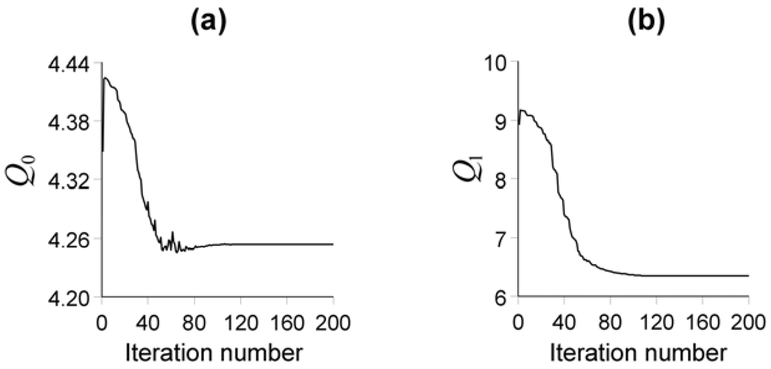
The minimizer of the nonlinear function
given in Equation (5) is obtained iteratively by the quasi-Newton method [
15,
16]. We implemented the quasi-Newton method using the Broyden-Fletcher-Goldfarb-Shanno (BFGS) algorithm [
16,
17]. The minimization of the objective function
[Equation (5)], with respect to the parameter vector
, by using the iterative quasi-Newton method, requires a stooping criterion. In our inverse problem using the entropic regularization the stopping criterion is based on the invariance of the first-order entropy function
[Equation (7)], which, in practice, is assumed to have occurred when the following inequality holds:
for five consecutive iterations, where
is the value of the first-order entropy measure at the
kth iteration.
The physical and geologic meaning of the entropic regularization has been explained by [
17,
18,
19]. The minimization of the first-order entropy measure favors an estimated physical-property distribution presenting local abrupt discontinuities. However, the minimization of
implies the minimization of
as well, and, if the latter is not deterred, it will favor unrealistic solutions, consisting of an estimated physical-property contrast distribution with predominantly null values and a few unrealistically large nonnull values. So, the minimization of
should be deterred. To counteract the minimization of
, it should be “maximized” not to attain in fact a maximum, but to prevent its excessive minimization. Thus, a judicious combination of the minimization of first-order entropy with maximization of zeroth-order entropy favors an estimated physical-property distribution characterized by regions with virtually constant physical property separated by sharp discontinuities.
In Equation (8) the variable γ1 controls the number of discontinuities in the estimated physical-property distribution. An optimum value for γ1 is the largest positive value producing no more oscillations or discontinuities than those expected for the physical-property distribution being interpreted. The variable γ0 must be assigned the smallest value necessary to prevent an estimated physical-property distribution presenting unrealistic pattern with predominantly null values and a few unrealistically large nonnull values. Among the numerous estimated physical-property contrast distributions fitting the data with acceptable precision, the entropic regularization favors an estimated physical-property distribution with locally smooth regions separated by abrupt discontinuities.
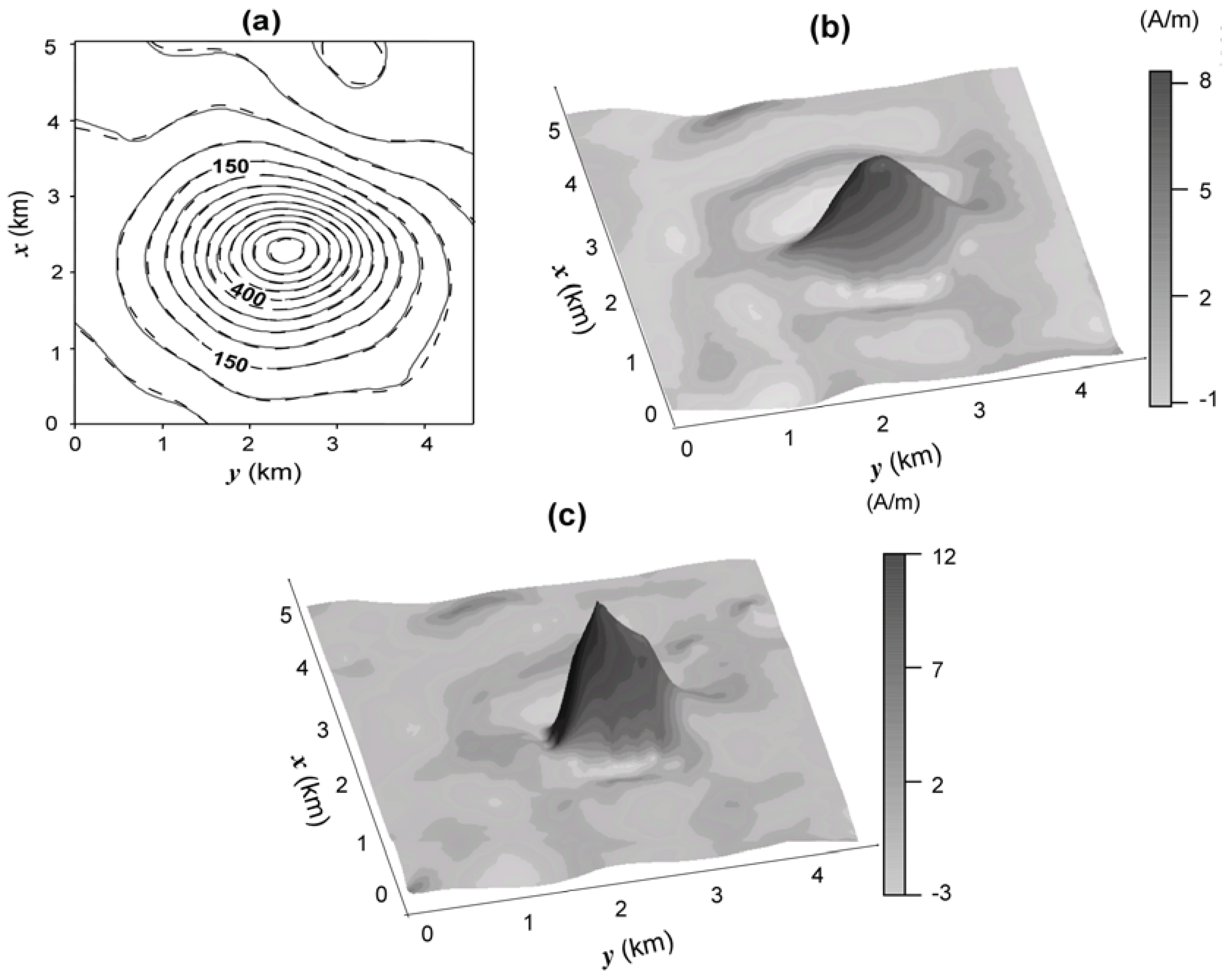
5. Application to Real Data
Here, we discuss an interpretation of the magnetic data from Butte Valley Stock, NV, USA shown by Silva
et al. [
18] that compare the estimated magnetization-contrast distribution produced by the entropic regularization method with that produced by the first-order Tikhonov regularization. The Butte Valley Stock is a buried skarn located on the southern border of a nonmagnetic intrusive body emplaced in nonmagnetic sedimentary rock. A skarn is a metamorphic rock that is formed by chemical processes related mainly to an igneous environment. It usually comprises the interaction between fluids from magmatic intrusions like granites and the host carbonate-rich rocks such as limestone or dolostone. The most common form of a skarn displays a ring-like shape. In the Butte Valley Stock, prospect for porphyry copper in the 60s and 80s identified copper and gold deposits in the area. Deep drill holes indicate that the skarn has a magnetic susceptibility of 0.63 SI and lies 800 m below the flight level, overlain by nonmagnetic sediments.
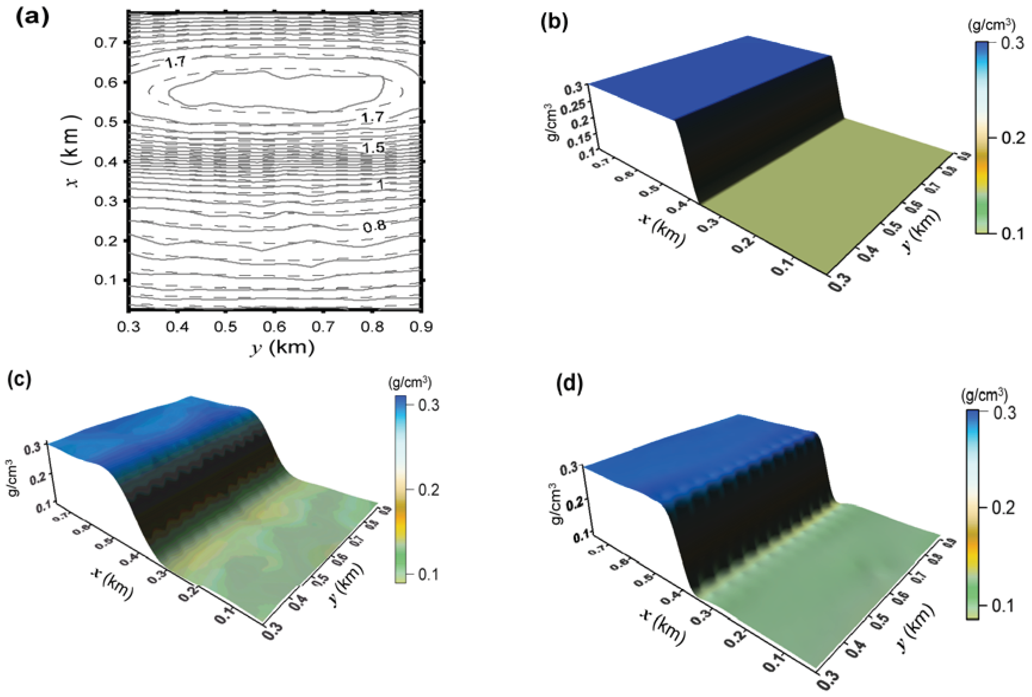
Figure 6a shows the aeromagnetic total-field anomaly (gray solid lines) above Butte Valley Stock, NV, USA [
5]. The flight height was 150 m above the ground surface. The geomagnetic field has inclination of 64.75° and azimuth of 15.2°. The anomaly shape suggests that the skarn magnetization is induced. Hence, the assumed inclination and the azimuth of the source magnetization vector are 64.75° and 15.2°, respectively. The interpretation model consists of a 22 × 19 grid of prisms along the
x-(north-south) and
y-(east-west) directions, respectively. Each prism is 0.24 km wide in both
x- and
y-directions, and its top and base are, respectively, 0.8 and 5 km deep.
Figure 6.
Butte Valley Stock. (a) Observed total-field aeromagnetic anomaly (solid gray lines) and fitted (dashed black lines) total-field anomaly (in nT) using the entropic regularization solution shown in (c). (b) Estimated magnetization-contrast distribution produced by the first-order Tikhonov regularization [
18]. (c) Estimated magnetization-contrast distribution produced by the entropic regularization with
γ1 = 3,385 and
γ0 = 100 [
18].
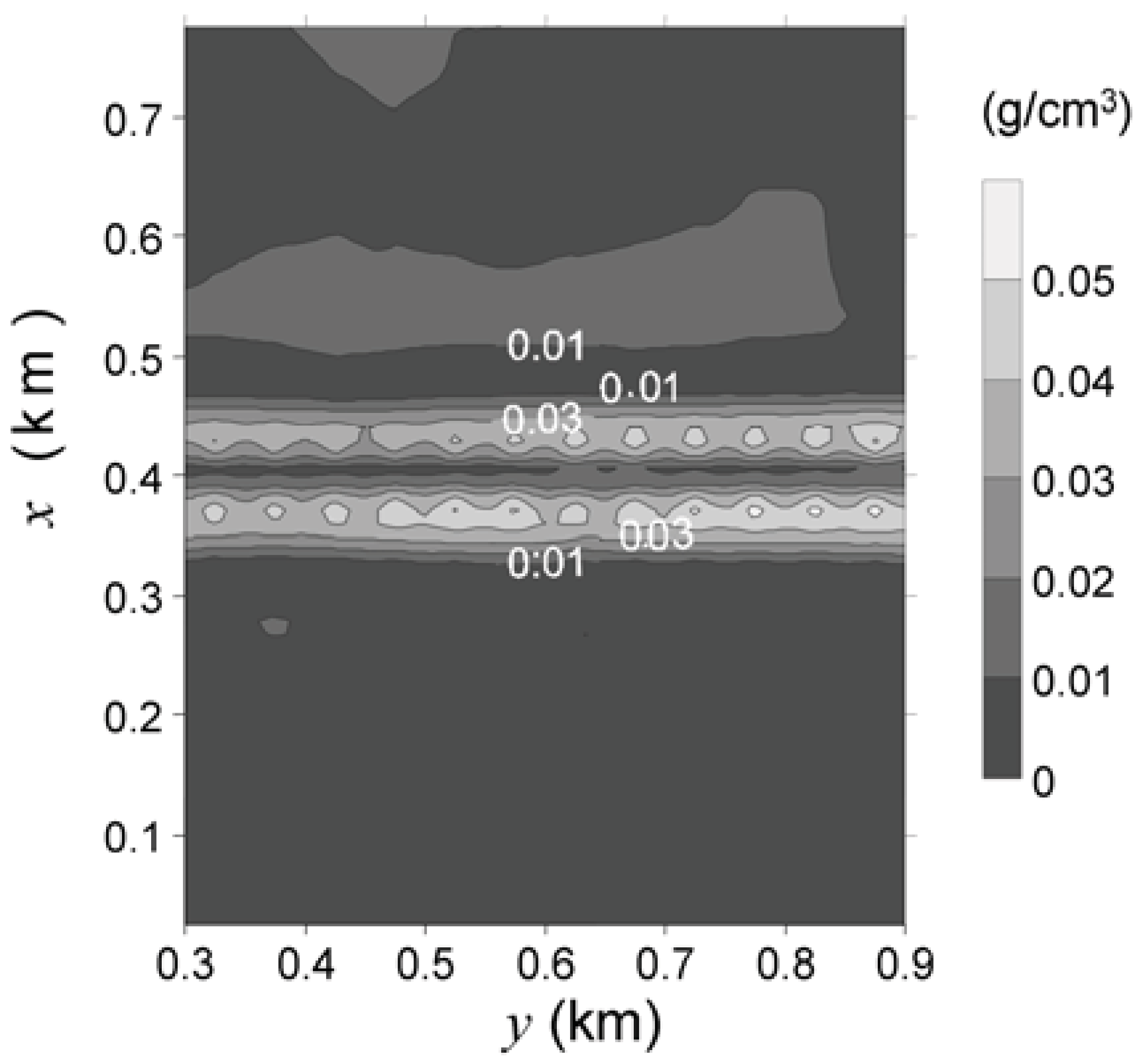
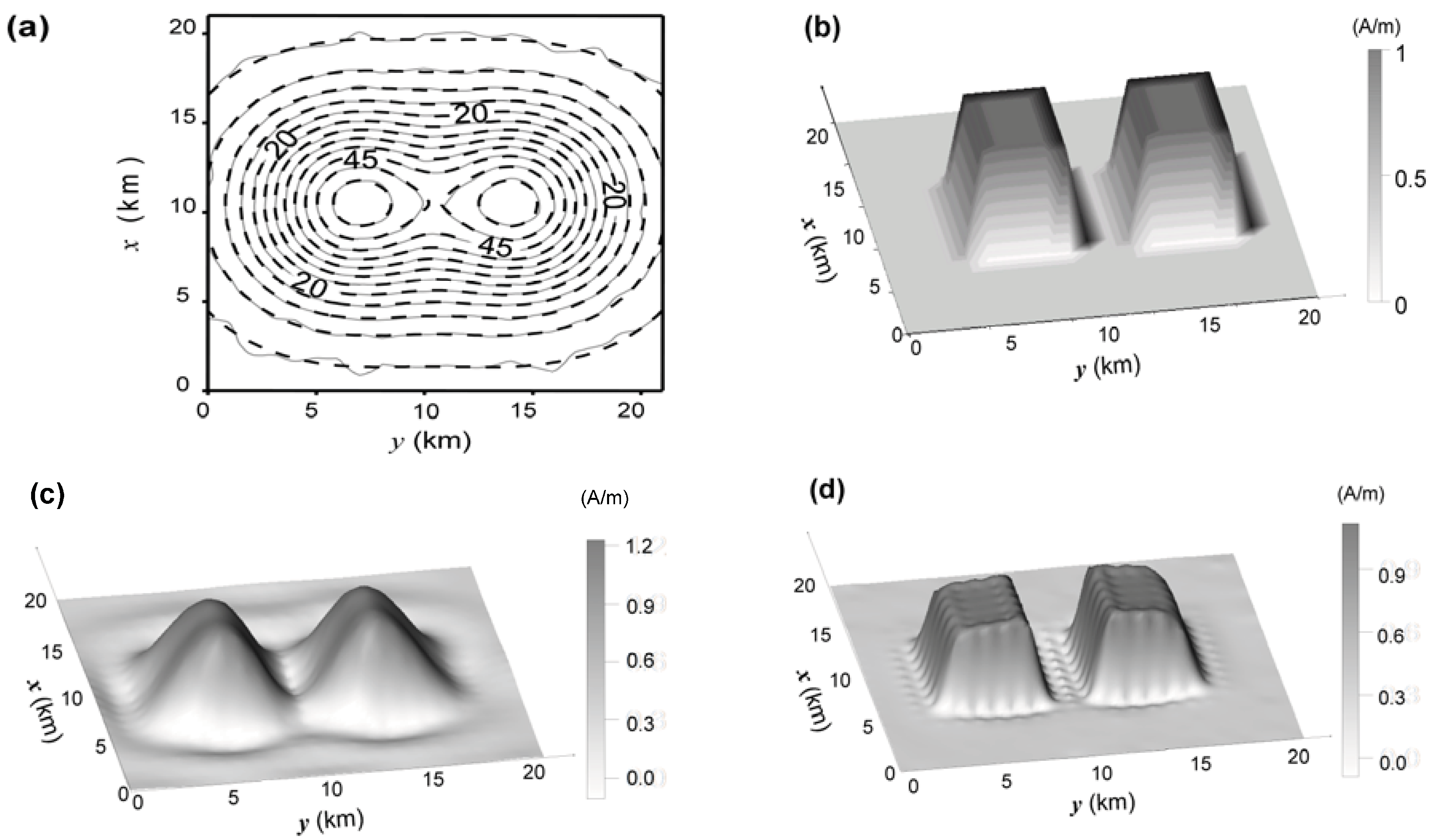
Figure 6(b,c) shows the estimated magnetization-contrast distributions using, respectively, the first-order Tikhonov regularization and the entropic regularization with
γ1 = 3,385 e
γ0 = 100. The first-order Tikhonov regularization result [
Figure 6(b)] presents, as expected, a smooth transition of the estimated magnetizations from the body center to the borders, preventing a clear delineation of the source outline. Moreover, a wide region of spurious negative magnetization-contrast values shows up around the source. Conversely, the estimated magnetization-contrast distribution by the entropic regularization [
Figure 6(c)] displays steeper gradients close to the source’s borders allowing a better delineation of its horizontal projection. One also notes the conspicuous reduction of the region displaying spurious negative values around the source. The entropic regularization estimates a magnetization-contrast distribution with smaller horizontal length and higher (13 A/m) maximum values of the estimated magnetization contrast. Compared with the first-order Tikhonov regularization, it produces smaller (10 A/m) maximum values of the estimated magnetization contrast. Under the hypothesis of induced magnetization, a magnetization of 13 A/m is associated with an estimated susceptibility closer to the measured value of 0.63 SI than the estimate of 10 A/m produced by the first-order Tikhonov regularization. The fitted anomaly produced by the entropic regularization is shown in
Figure 6(a) in dashed black lines.
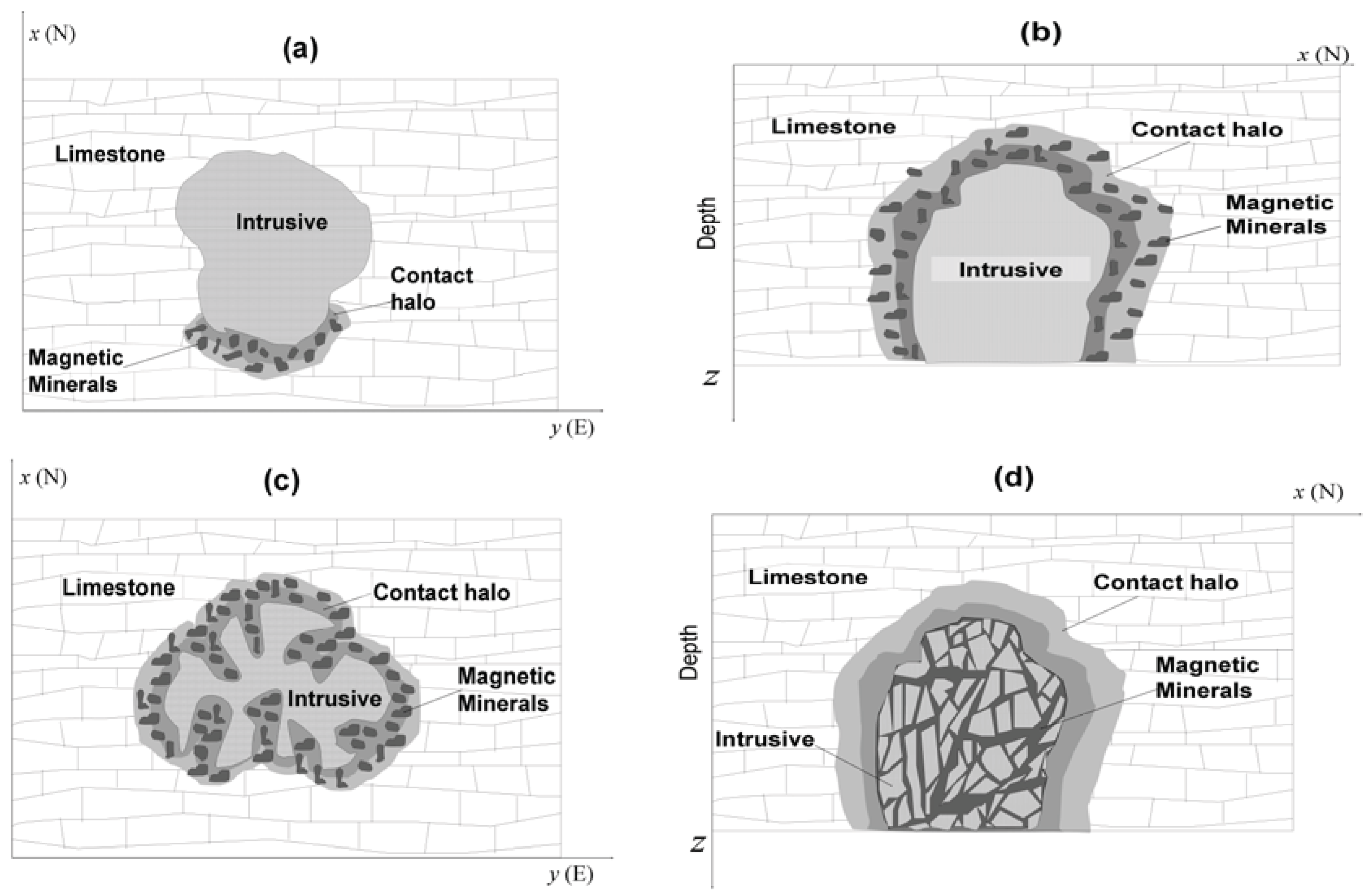
Figure 7.
Butte Valley Stock. Possible skarn emplacements explaining the absence of a ring-like shape of the magnetization-contrast map. (a) Exoskarn where the ion exchange between the intrusive and the host rock occurs along a limited portion of the intrusive border. (b) Exoskarn with top located below the erosion level. (c) Exoskarn whose intrusive rock has been emplaced with an irregular shape. (d) Endoskarn where the magnetic minerals are formed along faults and joints in the intrusive rock.
The most striking feature of the estimated magnetization-contrast distributions above the Butte Valley Stock [
Figure 6(b,c)] is the absence of an expected ring-like shape. Neither the first-order Tikhonov regularization [
Figure 6(b)] nor the entropic regularization presents noticeable difference with respect to the skarn shape. However the estimated skarn shape [
Figure 6(b,c)] is in accordance with the information that the Butte Valley skarn occurs on the southern border of the intrusive as illustrated schematically in
Figure 7(a). Additional explanations for the absence of a ring-like shape in the Butte Valley skarn are as follows. Firstly, the erosion level might have never exposed the intrusive top as shown in
Figure 7(b). Secondly, although not very common, the intrusive might have been emplaced with an irregular shape as illustrated in
Figure 7(c). Finally, the Butte Valley skarn might be an endoskarn [
Figure 7(d)] instead of the more common exoskarn shown in
Figure 7(a–c). In an endoskarn the magnetic minerals are formed along faults and joints inside the intrusive rock. We have discarded the hypotheses represented in
Figure 7(b–d) because of: (i) the geological information that the skarn occurs at the southern portion of the intrusion, and (ii) the geophysical information derived from the magnetization-contrast map that indicates a magnetic source with one of its dimension much larger than the other. Conversely, if one of the above alternative hypotheses were true, an isometric shape for the estimated source would be expected. This example shows that a judicious combination of geological and geophysical information may produce reliable information about the sources and contribute for the elaboration of a geological map.


