

Creating Location-Based Mobile Applications for Tourism: A Virtual AR Guide for Western Macedonia

Department of Communication and Digital Media, University of Western Macedonia, 52100 Kastoria, Greece
*
Authors to whom correspondence should be addressed.
Digital 2024, 4(1), 271-301; https://doi.org/10.3390/digital4010014
Submission received: 3 January 2024
/
Revised: 21 February 2024
/
Accepted: 22 February 2024
/
Published: 1 March 2024
(This article belongs to the Collection Digital Systems for Tourism)
Abstract
:Augmented reality (AR) applications are currently used in many fields for communication and educational purposes. Tourism is also a sector where augmented reality is used for destination marketing and cultural heritage promotion. This study will focus on mobile location-based AR applications and their potential in tourism. Such applications can guide tourists to places of interest and enhance their overall experience. The aim of this paper is to present a mobile application that was created for tourists visiting the region of Western Macedonia, Greece. The application was developed in order to guide the users in the region, entertain them, and educate them about the region’s sights, cultural heritage, and other special characteristics. The paper also aims to present a large set of features that are present in the application, including various types of AR (marker-based, markerless, and location-based) in order to provide designers who wish to create AR applications for tourism with new ideas. The application was validated by a usability test, and its features were evaluated by 39 participants who completed a questionnaire with 29 Likert-scale items. This procedure revealed the level of acceptance for the application features, and valuable feedback was also received during a discussion with the participants about how the application could be upgraded in the future.
1. Introduction
One of the first definitions of AR was given by Azuma in 1997 [1]. Azuma defined AR as 3D objects integrated into a real 3D environment in real-time, highlighting three characteristics: (a) a combination of real and virtual, (b) interactive in real-time, and (c) registered in 3D. However, since 1997, AR technology has evolved, and this definition, which is more aligned with image-based AR and the projection of 3D content in the real environment through devices such as mobile phones or headsets, does not include the various types of AR that exist at present. At present, AR applications include content that blends real-world settings with many forms of virtual information, such as video, sounds, 3D models, animation, and text; therefore, a broader definition that encompasses all types of AR was needed [2,3,4].
Such a definition was provided by Fitzgerald et al. [2], who define AR as including “the fusion of any digital information within real-world settings, i.e., being able to augment one’s immediate surroundings with electronic data or information, in a variety of media formats that include not only visual/graphic media but also text, audio, video, and haptic overlays”.
By exploring the literature, one can find many classifications of AR. One classification relies on the devices that enable the AR experience. AR can be enabled by wearable (e.g., headsets) and non-wearable devices (e.g., mobile devices) [5]. Probably the most common way of experiencing AR is through mobile devices and AR applications that run on IOS and Android operating systems. The advent of mobile AR apps is what made AR broadly accessible to the public. However, more expensive devices, such as AR headsets are also used to obtain an AR experience. Popular headsets on the market at present include Microsoft Hololens, Magic Leap, Apple Vision PRO, and Meta Quest 3. The headset devices that have recently been launched by Apple and Meta can enable both AR and Virtual Reality (VR) experiences. Companies and researchers are constantly improving wearable device technologies, and it would be no surprise if someday AR is experienced through devices as small as contact lenses [6].
Another classification of AR relies on the ways by which the experience is triggered. In this categorization, we have (a) marker-based (or image-based) AR, (b) markerless AR, and (c) location-based AR. In marker-based AR, the trigger that initiates the AR experience is typically a 2D image (street sign, graphic in a book, museum painting, product packaging, movie poster, etc.) or a 3D object (constructions such as buildings, bridges, statues, etc.). In markerless AR, as the term implies, we do not need an image to activate the AR content. The mobile device camera and other sensors are used to scan the user environment and determine where the digital content will appear. Typically, the user can choose a flat surface in a real environment and project digital information on that surface (a 3D model, 2D image, video, etc.). This information can appear in multiple ways, and the user can decide on the digital objects that will appear in the real world through the camera lens of the mobile device or through an augmented reality headset. There are many mobile applications that utilize this method to bring commercial goods or other exhibits to the users’ surrounding space. For example, the IKEA Place App [7] is an application that brings IKEA products into the users’ homes so that they can see how well they fit into their space. BBC Civilizations [8] is an augmented reality app that enables people to explore historical artifacts from UK museums in their environment.
The digital models that can be seen in Microsoft Hololens headsets are another example of markerless AR. Projection-based AR is also a type of markerless AR that uses projectors to display multimedia content (e.g., 3D images) onto flat, two-dimensional surfaces, such as building walls. Finally, location-based AR is a type of AR where content is activated when a user reaches a specific location. These applications are commonly experienced using mobile devices, and the user position is tracked by the GPS sensor of the mobile device. In the literature, location-based AR is either found to be in a category of its own or to be another type of markerless AR.
This study will focus on location-based AR applications that are aligned with the definition given by Fitzgerald et al. [2].
Augmented reality is currently used in many commercial, academic, and research fields. Tourism is another sector that harnesses the novelty of AR products. AR allows users to interact with the real environment, potentially enhancing the visitors’ experience [9].
In order to make an experience more engaging and enjoyable, techniques such as gamification and storytelling are often utilized in location-based AR, along with different types of informative multimedia content.
This study aims to present a location-based augmented reality application with many features and provide details about the design and development process. The application’s overall functionality underwent a usability test process to ensure that it is user-friendly and free from errors. The application features were presented to 39 participants, who evaluated the application features by filling in a Likert scale questionnaire consisting of 29 items. Furthermore, a discussion also took place after the presentation to receive more feedback from the participants. Short interviews were carried out to receive feedback from participants, who navigated points of interest in the city of Kastoria with the aid of the application.
The contribution of this paper to the existing body of literature on AR applications, and, more specifically, to the body of location-based applications, lies in the broad range of features that are present in this application, as well as the novelty that some of these features pose. The application combines all known forms of AR (marker-based, markerless, and location-based) with features that help users navigate to places of interest. The features of the application were, as previously mentioned, evaluated and discussed with the participants in the evaluation process, and new ideas came to light about the alternative uses of these features. Therefore, we anticipate that this paper will inspire those wishing to design and develop AR applications for tourism by providing them with fresh ideas and insights from the evaluation findings.
2. Related Work
In a relatively recent systematic review on virtual reality and augmented reality in tourism research, Yung and Koo-Lattimore [10] found that the tourism experience enhancement category was exclusively made up of studies on AR.
Seven studies [11,12,13,14,15,16,17] focused on how AR enhanced the tourism experience while visiting various locations.
Some examples, included in this review, explored AR as a tool that provided information to museum visitors [12] or could serve as a location guide [11,17]. AR is more suitable for these purposes than VR, which typically requires users to be stationary, since they cannot see or interact with the real world during a VR experience.
This review also found that AR, in the context of tourism experience enhancement, has been well-received by visitors in heritage sites, museums, and art galleries where there is an extensive dissemination of information [12,18].
However, concerns were expressed in some studies. For example, Dueholm and Smed, in their study [12], found that museum and heritage site managers are unwilling to embrace AR technology since there were concerns about whether the objective authenticity of the sites is maintained. Since virtual augmentations are often 3D, computer-generated, reconstruction models, heritage managers felt that these “copies” weakened the absolute and objective criteria on which toured objects were otherwise measured. Another concern is the quality of the content of these applications, and quality emerged as the most significant requirement in AR applications that serve as museum and city guides [12,18,19].
There are many examples of AR in tourism. The systematic reviews provided by Yung and Koo-Lattimore [10] and Liang and Elliot [20], and the recent metanalysis study [21] provided by Fan et al., as well as the study conducted by Loureiro and Ali [6], contain many such examples.
Concerning location-based AR, in addition to the information that can be provided to tourists in various multimedia forms during their visit to places of interest, gamification and storytelling are often utilized to make an experience more entertaining, engaging, and memorable.
Gamification is a methodology in which gaming mechanics are used in non-game environments to increase participation and engagement. Examples of gaming elements that can be introduced in non-game environments are challenges, rewards, competition, and role-playing. Applications that utilize such elements can intensify the feeling of “presence” in tourists [22] and create experiences that will be remembered due to the incorporated gaming dimension [23].
For example, the authors of [24] implemented an Augmented Reality (AR) treasure hunt game to enhance a visitor’s enjoyment and learning while touring a culturally rich city: the city of Valletta, the 2018 European Capital of Culture.
In previous studies, the authors of this paper designed and implemented location-based AR games for cultural heritage education [25,26], as well as for destination marketing [27]. These applications made use of gamification techniques (i.e., collection of points, digital artifacts, issuance of awards), and one of them also utilized the art of storytelling [25].
Storytelling is often adopted in AR applications. People can mentally process and organize information more efficiently when it is communicated through a story [28]. Storytelling is a very efficient method of communication, and any advancements in media technologies that enable people to tell stories in new and more engaging ways can have a significant impact. Storytelling is also an important method of education and instruction. Augmented reality (AR) can utilize new forms of storytelling that enable virtual content to be connected in meaningful ways to particular places, people, or objects [29].
An early example of an AR location-based game that utilizes storytelling to provide entertainment and education to tourists is REXplorer [30]. REXplorer is an AR game that was intended for visitors to the town of Regensburg in Germany. During the AR-guided tour, the tourists interact with virtual characters in historical town buildings. These virtual characters are the spirits of historical figures that lived in the past. The spirits prompt the users to complete game tasks in specific city center locations. By completing these tasks, participants indirectly explore the town’s historic city center and learn history in an entertaining manner.
A similar initiative to REXplorer is the SPIRIT research project [31]. In this application, spirit figures tell stories that occurred during their lifetime at the Saalburg Roman Fort, which operates as an outdoor museum site at present.
Another example is the location-based adventure AR game Viking Ghost Hunt (VGH) [32]. The game is based on a Gothic ghost story set in Viking Dublin. In this game, the users take on the role of a paranormal investigator who moves around in the city of Dublin, hunting ghosts, gathering evidence, and solving mysteries.
The “Unlocking Porto” app [33] is another application that combines gamification with storytelling. Users of this application are prompted to visit Porto’s main sights and play small games once they are there.
Spotlight Heritage Timisoara is a digital cultural initiative of the Politehnica University of Timisoara that reveals, through digital storytelling, the city of Timisoara through stories of cultural and historical heritage, communities, and neighborhoods, interwoven with the personal stories of the inhabitants of yesterday and today [34]. The initiative employs an interactive touchscreen table, desktop/laptop, mobile, and AR platforms.
Another example of an AR interactive digital storytelling application is presented in [35]. The study deals with a mobile AR application developed to guide visitors in the interpretation of the frescoes inside the Basilica of Saint Catherina of Alexandria in Galatina. The study also analyzes the relations among usability, user experience, and mental workload factors in AR-based digital storytelling.
The authors of [36] created an AR application with gamification features for the city of Bydgoszcz in Poland. Bydgoszcz is a city that lacks the most popular characteristics that attract tourists, such as sea, sand, and sun, and the authors explored the potential of using AR applications to increase the number of visitors to the area. It is worth mentioning that the Western Macedonia region in Greece is similar to Bydgoszcz, since it is also far from the sea, which is a typical asset that attracts tourists to Greece.
3. Materials and Methods
The location-based AR application titled “Virtual Guide for the mountainous regions of Western Macedonia and the City of Kastoria” is an application for mobile devices that run on an Android operating system. The application was developed using Android and ARCore SDKs (https://developers.google.com/ar, accessed on 1 December 2023).
ARcore supports various features, such as marker-based AR and markerless AR, as well as a location-based AR. Images that are used as triggers in marker-based AR can be included in an image database or added in real-time using the device. Once registered, ARCore will detect these images and their boundaries and return selected multimedia elements (3D models, transparent videos, animations, etc.). ARcore supports motion tracking, meaning that, as the phone moves through the world, a process called simultaneous localization and mapping (SLAM), is used to understand where the phone is relative to the world around it. ARcore also supports environmental understanding, meaning that it can detect feature points and planes. Moreover, ARcore supports light estimation, meaning that information about the lighting of the surrounding environment is detected, and the level of lighting of the virtual objects is adjusted to increase the sense of realism.
The application of the “Virtual Guide for the mountainous regions of Western Macedonia and the City of Kastoria” utilizes all three popular types of AR—location-based, marker-based, and markerless AR—and incorporates various multimedia elements, such as informational text, audio, 3D models, animation augmentations, (virtual talking avatars), videos (plain and transparent), Google Maps for navigation, Google Street View, and 360° photos. It also uses the Google text-to-speech service and connects with the ChatGPT service to provide chatbot services to tourists.
With this application, users are motivated to visit various mountainous destinations in the region of Western Macedonia, as well as places within the city of Kastoria, and receive information in various multimedia forms about the history, cultural and environmental heritage, demography, and other aspects of these places. More specifically, information in the application is delivered via text, as well as links to sites and videos that contain more detailed information. In many cases, information is delivered by virtual talking characters. Users can encounter three categories of virtual characters: (a) virtual characters that look like ordinary people, (b) famous people associated with the history of the region, and (c) figures from Greek mythology. The characters that look like ordinary people typically provide information about the visiting place, while the historical figures and the mythological characters narrate stories or memories from their life. As mentioned in Section 2, storytelling is a powerful communication method that can enhance an AR experience [29].
To produce the virtual animated characters, an AI generative software tool was used (Heygen platform, https://www.heygen.com/ (accessed on 1 December 2023). Previously, advanced expertise and many working hours were needed to create such content. Now, generative AI platforms can aid designers in creating multimedia content such as illustrations, 3D models, and animations much more quickly and without the advanced expertise that was needed before.
A usability test is used to ensure that the application is comprehensive, user-friendly, and without errors. In this process, a mixed approach was adopted that combined the thinking-out-loud method and the coaching method. Furthermore, the application was presented to a sample of students, and its functionality and features were evaluated using a Likert-scale questionnaire. A discussion also took place with the participants to receive feedback about how the application could be improved or alternative uses of the present features. Interviews were also conducted with a small number of students, who downloaded and used the application to visit places of interest and obtain more insights into the application’s functionality.
4. The Application “Virtual Guide for the Mountainous Regions of Western Macedonia and the City of Kastoria”
Western Macedonia is a region in Greece, close to the Albanian border, with four prefectures (or regional units): Kozani, Florina, Kastoria, and Grevena. Western Macedonia is a region that could undoubtedly benefit economically from an increase in tourism, since it has one of the highest unemployment rates in Greece. It is worth noting that the area attracts fewer tourists compared to other Greek destinations located near the sea (like the islands), since sea and sand are what most tourists are looking for when they visit Greece. Therefore, initiatives that strengthen the region’s tourism are vital for its economic development. Furthermore, particular emphasis could be given to the mountain locations of Western Macedonia, since these are less known than the four capitals of Kozani, Kastoria, Florina, and Grevena.
Therefore, the creation of the application aimed to promote the mountainous destinations of Western Macedonia, through a mixed-reality experience, in order to attract more tourists to the region and enhance the tourist experience.
The initial version of the application was developed under a project called Agrotour (https://agrotour.uowm.gr/, accessed on 11 December 2023). The project aimed to strengthen the research and development in many areas that could boost the economy of Western Macedonia, such as agrotourism, smart farming, stock raising, bioeconomy and agri-food, and new technologies in farming.
The initial version of this application was briefly presented in [27], together with other applications that were developed under this project. However, the development of this application was continued, and the application contains many features that did not exist in the initial version. Furthermore, the application now contains many places of historical, cultural heritage, and environmental interest in the prefecture of Kastoria, which is the town in which the Digital Media and Strategic Communication lab of the Department of Communication and Digital Media resides.
4.1. Application Description: General Features
By using the application, visitors to the region can be guided to mountainous destinations in the four regional units of Western Macedonia, Kozani, Kastoria, Florina and Grevena, but also places of interest within the city of Kastoria. For this guided tour, the Google Map API, which is incorporated in the application functionality, is used.
The application utilizes many features of augmented reality technologies with the main aim of promoting tourism in Western Macedonia and educating visitors on various aspects of the target destinations, such as the history, tradition, natural environment, and cultural heritage.
When launching the application, the first screen that appears is a menu that includes four image buttons for the respective regional units, an image button for an interactive route (mountain trail Kastoria→Psalida), and an image button for the city of Kastoria (Figure 1).
By pressing any of the four buttons of the regional units, the users are forwarded to another menu with two options: “Interactive Map” or “Point of Interest (PoI) list”. By choosing one of the two options, the users decide how to continue the navigation (Figure 2).
If the “Interactive Map” option is chosen, a map appears (interactive map in normal, satellite, hybrid, or terrain mode), and the users are able to see the destinations in relation to their location. By choosing any of the destination map points, the users can see a relevant label with more information, and they can also navigate to these places through the Google Map API that was integrated in the application (Figure 3).
Through the “PoI list”, the users can visually select some points of interest through the menu items. The order of appearance of the proposed points is dynamic, and depends on the location of the user and his/her distance from the points of interest (Figure 4).
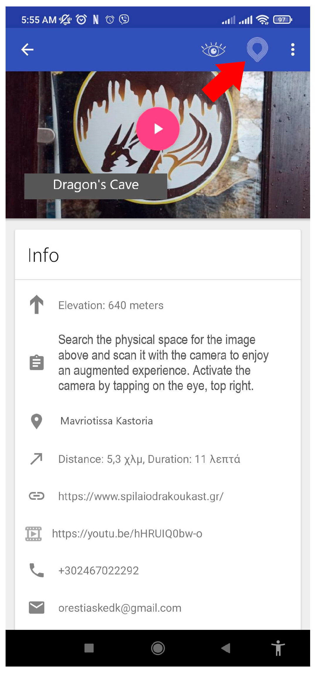
For each point of interest, a new screen appears with information that is related to the history, geography, economy, demography, cultural heritage, and the natural environment of the chosen place. In particular, the information tab, depending on the point of interest, may contain the location, altitude, distance from the user’s location, link to a relevant website, link to a relevant video on YouTube, telephone, email, relevant photos, and a map of the area, as well as detailed description of the destination (Figure 5 and Figure 6).
In addition, the users can choose to listen to an audio narration (audiobook) of the detailed description instead of reading it. The audio is obtained through Google’s Text-To-Speech API. This feature can be useful when walking and driving, and could also be useful to people with limited eyesight.
Through the option “Street View”, the users can also virtually visit a selected place through Google Street View (Figure 7). These places can also include interior spaces such as the interior part of a museum (Figure 8).
It is understandable that all this information can be delivered without visiting the places of interest. If the users decide to visit these places, they can select “Navigate” (see Figure 6), and they will be guided through the Google Map API to the chosen destination (Figure 9). Moreover, if the users want to visit many of the suggested places, they can activate the built-in navigation feature for a multipoint route. With this feature, they can follow the optimal route that passes through these destinations (Figure 10).
Another feature of particular interest is the “Favorites” option, through which users can choose their preferred destinations from all the proposed points presented in the “Interactive Map” or the “Point of Interest (PoI)” menus. Once chosen, these destinations are then added to a separate menu item called “Favorites”. Then users can then create a navigation plan of the optimal multipoint route to navigate to all the places in “Favorites” (Figure 11). In cases where users want to search for destinations by keyword, they can click on the characteristic search button.
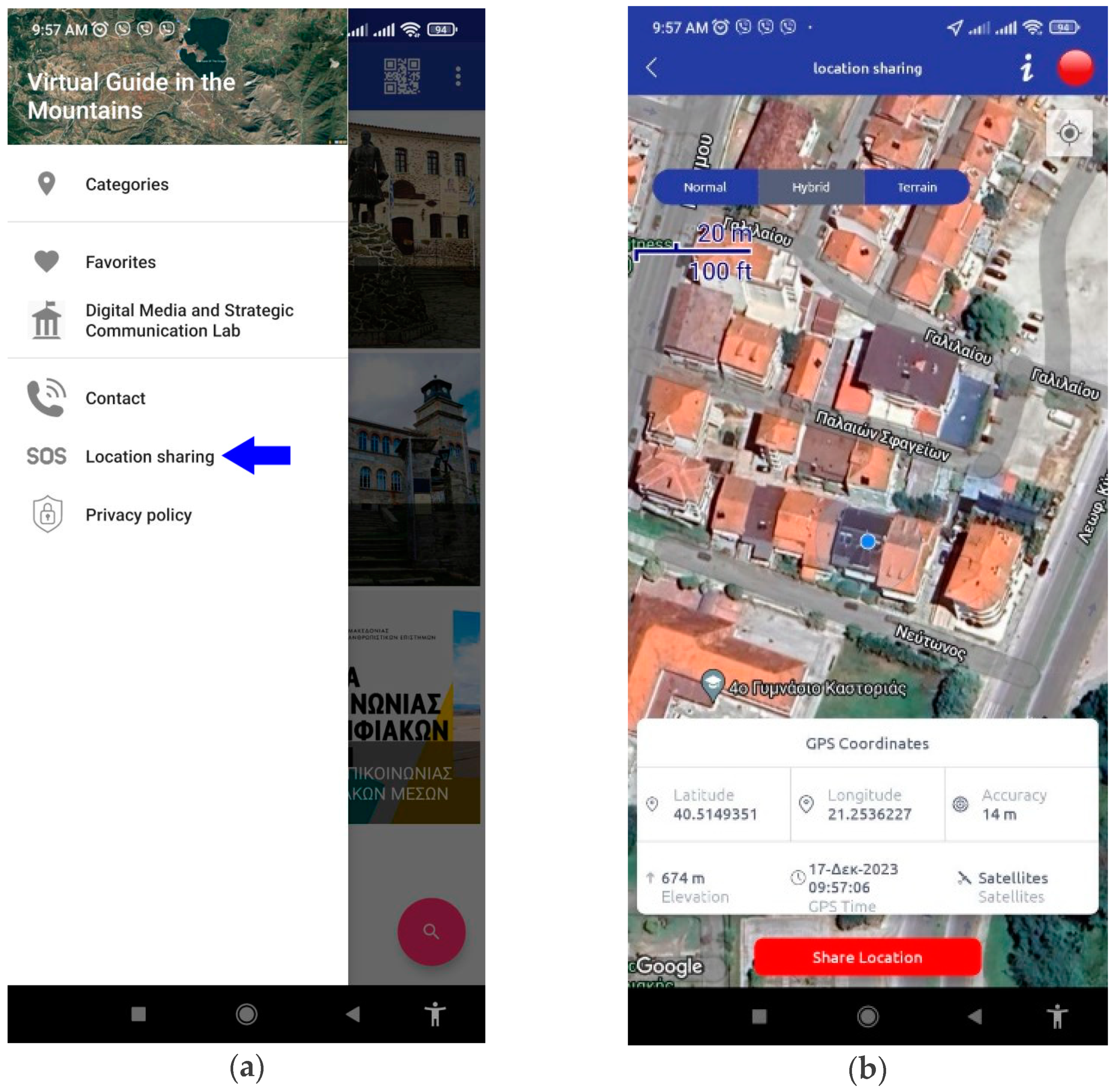
In addition, users can share their location at any time by pressing the “Location Sharing” menu item. This option can be chosen in many cases, such as when sharing an interesting location with friends or in case of an emergency (Figure 12).
Therefore, users can experience a percentage of the application content (e.g., information regarding destinations) without actually visiting the featured destinations. However, if they decide to visit some (or all) of the destinations, they will be rewarded with augmented reality experiences. All known types of augmented reality are present in this application; the augmentations can be marker-based (Section 4.3), markerless (Section 4.5), or location-based (Section 4.6).
4.2. Navigating in Nature Paths
One of the interesting features of the application is that it also provides a means of navigation along nature paths. The idea of using augmented reality in nature paths is also present in other initiatives. For example, the authors of [37] developed and evaluated an augmented reality mobile application to guide visitors on hiking trails on the island of Santa Maria, Azores. The application mainly consists of two modules: navigation and augmented reality. The users navigate through the hiking trails and are notified when they are close to a point of interest, where AR content is available. ARcore SDK was used to activate the 3D objects at the points of interest. Three-dimensional virtual objects were developed with Blender (e.g., placards with informative text, treasure chests, fossils, artifacts related to the local tradition).
Regarding this application, the GPS points of a mountain path that leads to a spectacular panoramic view of the city of Kastoria were gathered and stored in the application database. Then, these points are made available to the users through the application user interface (Figure 13A–C). The users can use an Interactive Map (Figure 13A) or the List of Poi (Figure 13B) to be guided through the path. The option in Figure 1, Kastoria→Psalida (the name of the nearby mountain), activates this guided hiking tour. Furthermore, users receive information about the path, as can be seen in Figure 13C.
4.3. Marker-Based Augmentations
In the case of marker-based AR, augmentations are usually activated by scanning a marker, which can be a 2D image (e.g., street sign), or a 3D object (door, statue, etc.). Digital content appears through the camera lens of the mobile device, and this content can be displayed in many multimedia forms (text, image, 3D models, video, animation, sound, etc.).
Users are informed about image-based AR points via selected menu items in the application (places) with a message containing the following: “AR SPOT: Search in the physical space for the image above and scan it with the camera to enjoy an augmented experience. Turn on the camera by tapping on the eye, top right”. The message appears in the info tab, as can be seen in the images of Figure 5.
These “AR spots” are image-based markers that activate multimedia content. Various signs are used as image triggers. These signs contain information, directions, location details, graphics, logos, drawings, and photographs. Depending on the location, the multimedia content includes virtual 3D animated characters that provide information or tell a “story”, as well as transparent videos and 3D gLTF models.
Images from the mobile camera are recognized using ARCore, and the placement of the augmentations in the real world is achieved using Sceneform API.
4.3.1. Mythical Characters
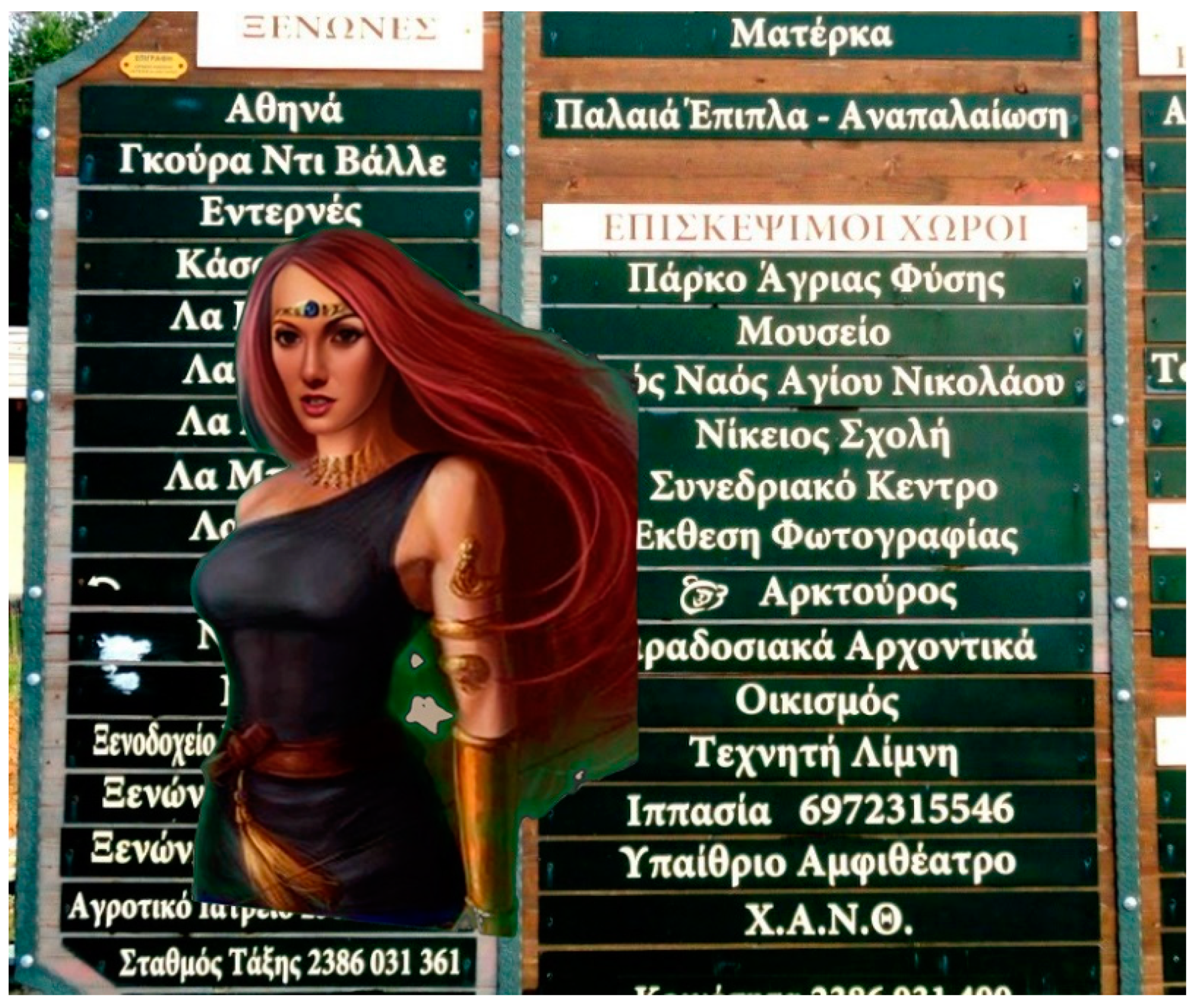
When the users visit the village of Nimfeo in the regional unit of Florina, the application prompts them to look for an information sign at the entrance of the village in order to obtain an augmented reality experience. By scanning this sign with a mobile phone camera, a virtual character appears in front of them in the form of a 3D model representing a figure from Greek mythology, “Callisto” (Figure 14). Callisto’s 3D cartoon model narrates the myth of the “Great Bear and Little bear” (the constellations known as Ursa Major and Ursa Minor), as well as explaining why the goddess Hera, in order to protect her from god Zeus, transformed her into a bear. This myth is related to the area as the village hosts a bear refuge. The bear refuge is home to bears that have lived most of their life in captivity and cannot be reintegrated into the wild. At the end of her narration, Callisto prompts the users to look behind them in order to see another augmentation, that of a bear. ARcore has the ability to place virtual content around the users’ position and anchor this content to specific locations.
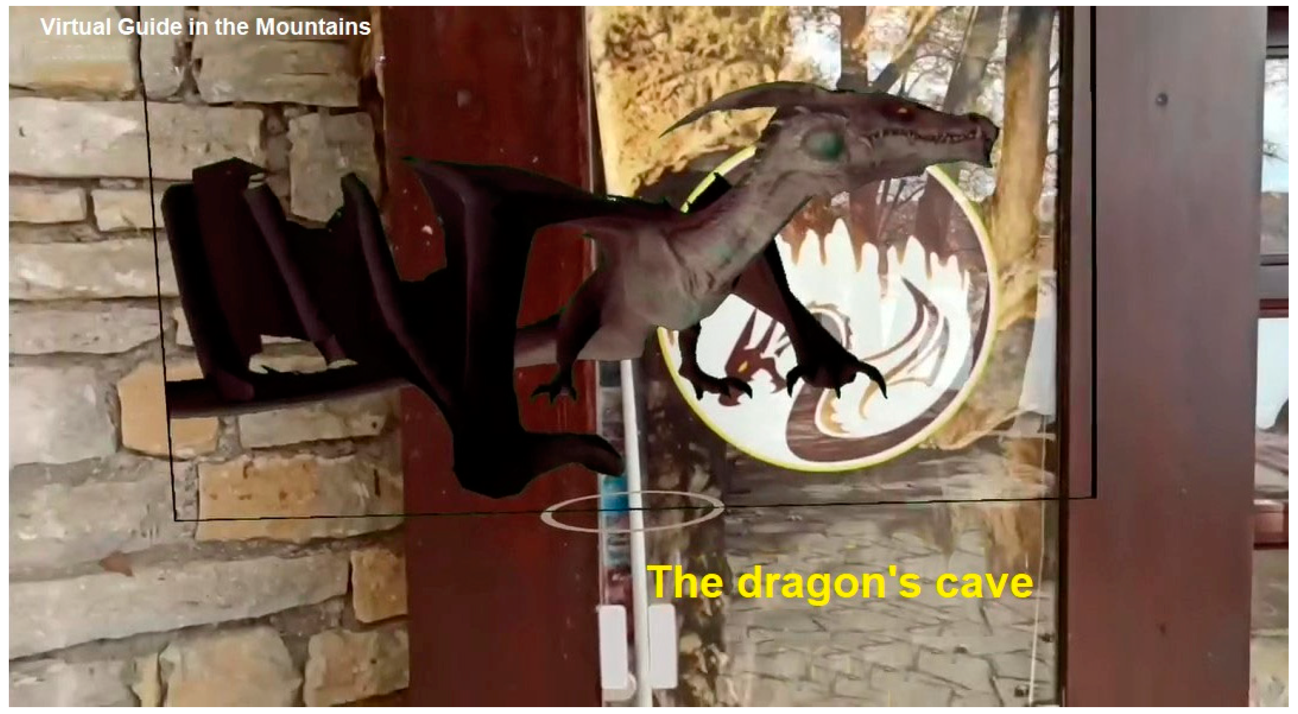
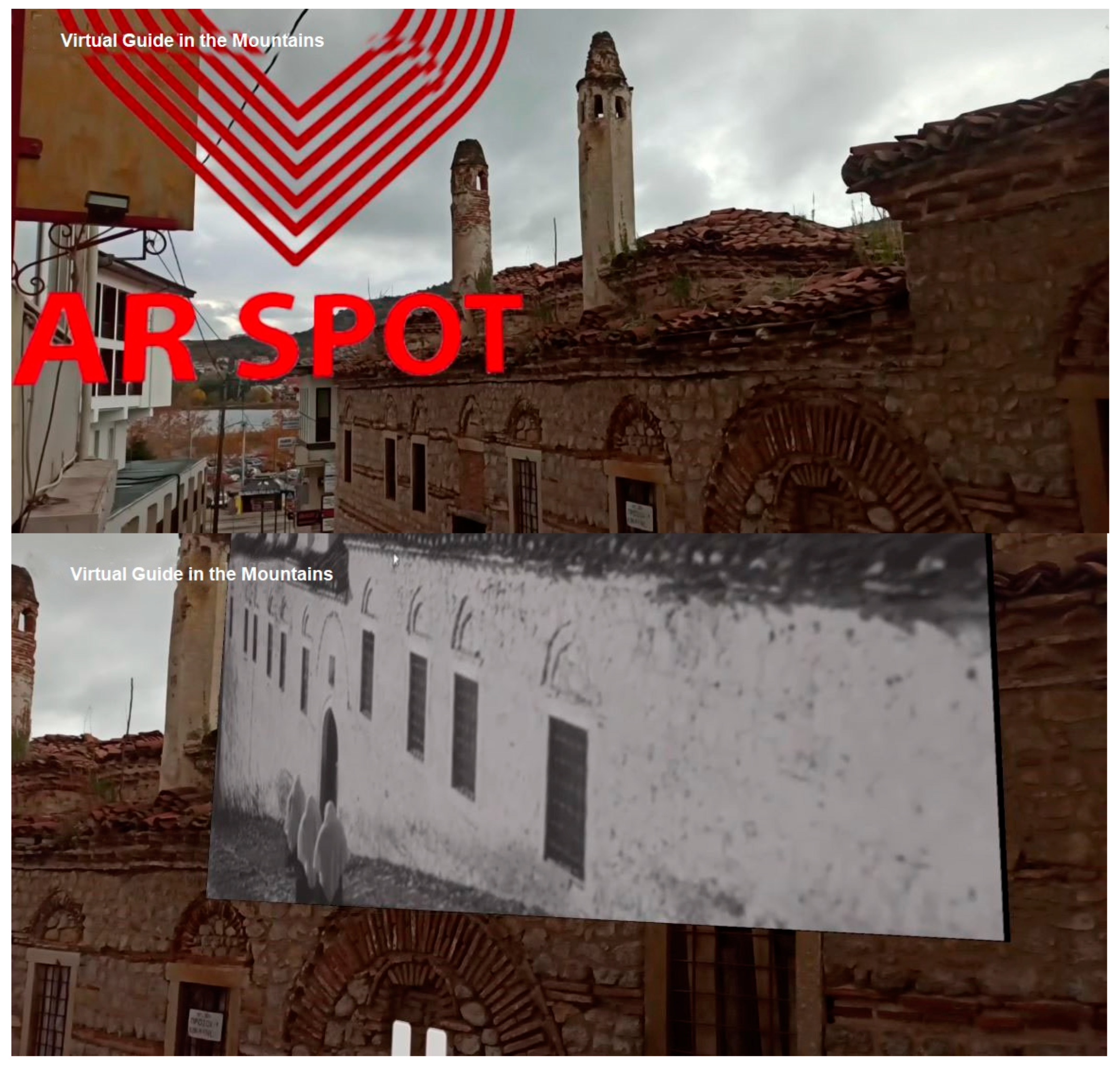
In the Dragon’s cave, one of the well-known sights in the city of Kastoria, the user can scan a graphic on the information sign at the entrance of the cave and watch a mythical dragon come to life and narrate the story of the cave, which has seven underground lakes and ten rooms that were once a gold mine guarded by the dragon (Figure 15).
4.3.2. Augmentations of Historical Figures
Furthermore, in other places, the users can encounter historical figures who lived in the area of Western Macedonia. These figures come to life and narrate stories and memoirs, expressing personal views, reciting poems, and reading letters sent to relatives. The poet Athanasios Christopoulos appears when an information sign in the city of Kastoria is scanned with a mobile phone camera and recites one of his most famous poems (Figure 16). Ion Dragoumis, a Greek diplomat, politician, and writer, comes to life when the street sign at the entrance of the village Vogatsiko is scanned. More specifically, when the street sign is scanned by a mobile phone camera, Dragoumis’ virtual character appears and narrates excerpts from his memoirs (Figure 17). Pavlos Melas, a famous historical figure, appears at another location near the Museum of Macedonian Struggle. Mellas was a Greek army artillery officer who took part in the Greek–Turkish War of 1897 and was one of the main protagonists in the Macedonian Struggle. By scanning the street sign that shows the way to the museum, the virtual character of Pavlos Melas appears and reads a letter that he sent to his parents to explain his reasons for his participation in the liberation struggle of Macedonia (Figure 18). Ioannis Farmakis, a famous historical figure of the Greek Revolution of 1821, is brought to life by scanning his statue in the village of Vlasti and narrates the details of a battle that took place in this area (Figure 19).
4.3.3. Informative Augmentations
On the north side of the city of Kastoria, by scanning an existing information sign for the municipality, the visitor is given the opportunity to travel back 100+ years through a video that was shot at the same exact point in 1918. The video shows fishermen of the time, at work with their traditional wooden boats (Kastorian boats). Through this video, the user can also understand the geomorphological changes that have taken place in the area due to human intervention, giving them a sense of the past and the present (Figure 20).
One of the sights of the city of Kastoria that has not received the attention that it deserves is the Byzantine wall. The Byzantine wall’s ruins are something that tourists can miss, since the monument is not well preserved and not promoted. AR applications can also be used to bring monuments that are otherwise hidden into the spotlight.
With the help of the application, the users can be guided to the Byzantine wall’s ruins, and, once they are there, by scanning a wooden door with the camera of their mobile phone, they can receive an enriched augmented experience (Figure 21). This experience includes a virtual guide and other digital information. The guide is a real person that provides information about the history of the Byzantine wall. The transparent video of this virtual guide was captured using a camera and a green screen and was edited to remove the background. In addition to information about the wall, the virtual guide also provides navigation instructions and instructions on how to rotate and move the mobile phone in order to search the space for more virtual information, which will appear in the surrounding space. The virtual guide prompts the users to turn the camera to the right and view another transparent video that presents the evolution of the Byzantine wall over time in relation to the actual point where the user is located. Additional information is also displayed in the surrounding space, such as a relevant website (www) with more information about the wall, a relevant video (YouTube), email, telephone, and extra audio information (audiobook). Finally, the virtual guide prompts the user to turn around and explore a 3D model.
Another example of augmentation is virtual guides that are computer-generated but have the look of a real person. Such avatars are used to provide information, such as the guide in Figure 22, who appears via location-based AR when the users arrive at the Department of Communication and Digital Media in Kastoria. This virtual character provides information about the lab of Digital Media and Strategic Communication using audio narration. Furthermore, the virtual character prompts the users to receive more information about the department if they wish by looking around to see a hotspot containing an informative video in YouTube and a link to the official webpage of the department (WWW link), as well as contact details.
4.4. Creating the Virtual Characters Using Generative AI Tools
Apart from the real person that was used in Figure 21, the virtual characters were created using a generative artificial intelligence (AI) tool (Figure 14, Figure 15, Figure 16, Figure 17, Figure 18, Figure 19 and Figure 22). The term “Generative AI” refers to algorithms (e.g., OpenAI and DALL-E) and tools that use AI APIs to create content by providing specific guidelines. The content can take any form, such as text, audio, programming code, illustrations, images, animations, simulations, and videos. The recent unprecedented advancements in this field have had a significant impact on the way that content is created. At present, several AI tools exist that can be used to create content in both textual and multimedia forms (Canva AI, Midjourney, Stable Diffusion, FireFly, etc.).
In our case, the purpose of using such tools was to create virtual talking characters, either by choosing avatars that resembled real people or by giving life to historical or mythological figures. By searching the Internet for available generative AI platforms and by trying out many of these software tools, an AI video generator platform called Heygen (Heygen: https://app.heygen.com/, accessed on 1 December 2023) was chosen. In order to create the character animations of historical and mythological figures, a particular procedure was followed. First, images of the characters were found and uploaded to the Heygen platform. These images were either drawings or old photos of historical figures (e.g., Figure 16, Figure 17 and Figure 18), or illustrations that represented characters from mythology (Figure 14 and Figure 15). Images that resembled real people that were available on the Heygen platform were also utilized (e.g., Figure 22). After choosing the images, the background was removed, following a certain procedure, and the resolution was adjusted. Then, the animated talking character was created by inserting the related text (information, story, personal view, etc.) and converting this text into speech using the text-to-speech capabilities of the platform.
4.5. Markerless AR
Through another menu, the user is also given the option to play with markerless AR options. This option is provided for entertainment, and it can be activated in any place (e.g., the users’ home).
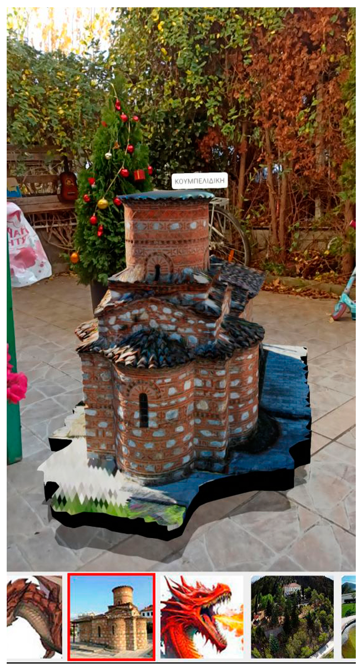
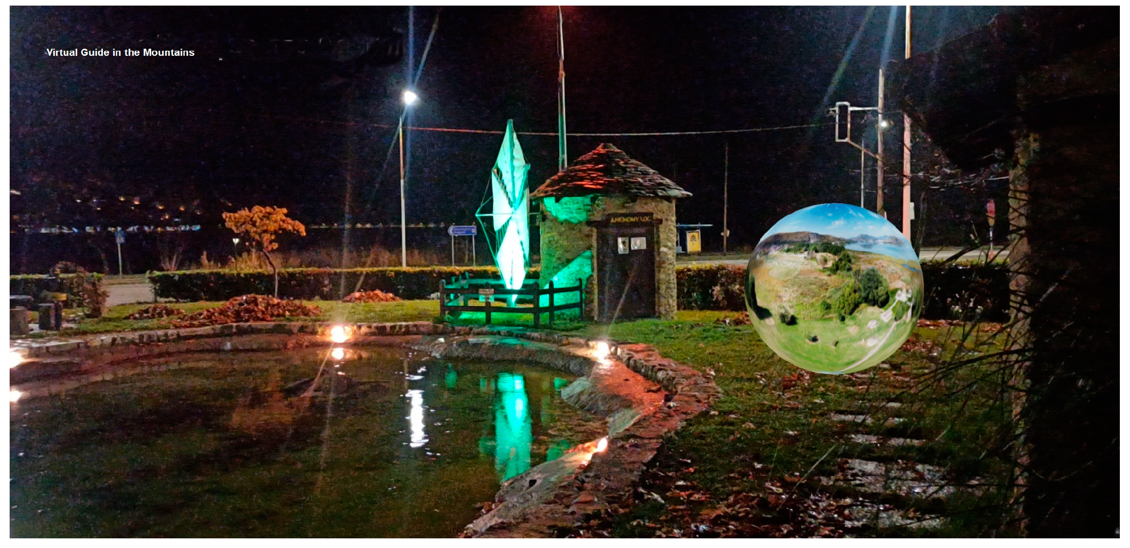
By choosing the right menu option, the users enter an environment where digital content can be selected and displayed, on-demand, on flat physical surfaces (table, floor, etc.). Flat surfaces are recognized by ARCore SDK and the placement of 3D gLTF models on the flat surfaces can be achieved using Sceneform API. The users can choose a 3D model from a series of 3D GLB models at the bottom of the mobile screen and project these 3D models into their space (e.g., the floor of their home). Currently, the users can project 3D representations of monuments such as the “Koumbelidiki”, a Byzantine church in the city center of Kastoria (Figure 23), and 3D animations such as the imaginative representation of the “Cave Dragon”, a mythical being that lived in a cave in Kastoria (Figure 24). The users can also project a “VR Magic Sphere” (or VR portal, as it is called in a subsequent section) that, in this case, acts as a virtual entrance to the Kastoria Aquarium. When the users walk into this magic sphere, they enter the interior of the Kastoria aquarium through a 360°-degree photo (Figure 25). The 3D models of the monuments (e.g., Koubelidiki church) were created using photographs from a camera and photos taken from a drone, by stitching these photos together using photogrammetry software 3DF ZEPHYR version 6.5. Three-dimensional models were also created using the 3D modelling program Blender 3. The “VR Magic Ball” was created also using the 3D modelling software Blender and a 360° photo (captured by a 360° camera)
4.6. Location-Based AR
Location-based AR (also known as location-aware AR), as previously mentioned, is the third type of AR and, in the literature, it can also be referred to as a subcategory of markerless AR. Unlike marker-based AR, location-based AR does not require any image or other marker to trigger the AR experience and identify where to place the virtual objects in a real-world environment. In location-based AR applications, augmentations are triggered when users come within a certain distance of a point of interest. The digital augmentation display takes place on the screen of the mobile device (smartphone or tablet), while the GPS sensor of the mobile device detects the user’s position. The gyroscope and magnetometer (digital compass) are also utilized to detect the user position. In the case of the current application, in addition to the marker-based AR spots, the user can also activate location-based AR for the same points of interest, as well as for points of interest without a marker (e.g., street sign). The location-based AR is triggered by clicking the characteristic pin icon next to the eye icon in the information tab (Figure 26).
If this option is chosen, the augmented experience is activated, and a characteristic red icon with the ARspot indication appears somewhere in the space around the user. The users are also prompted by an audio message informing them that they have reached the point of interest, and that the AR SPOT is detected (Figure 27 and Figure 28). This feature can be helpful in cases when an image-based trigger is absent or when an image-based AR trigger cannot function properly, such as in low light conditions (e.g., nighttime). Often, in low-light conditions, AR tools have trouble detecting the image triggers. In Figure 27, a video from the past is activated when the user reaches a specific monument in the city of Kastoria, the Islamic seminary “Mendreses”, showing a very old video that was shot during the Ottoman era. In another location, next to the lake, the users are notified that they have reached an AR spot, and a characteristic image appears on the screen. When they click on the image, a video is activated that shows footage from underwater life that was filmed at a nearby spot in the lake using an underwater drone (Figure 25).
4.7. ChatGPT
The ChatGPT service can also be utilized through this application through the ChatGPT API. Ideally, the tourists will be able to freely ask the chatbot about anything regarding the destinations and their trip, and the embedded ChatGPT service will respond to their query. This is an option that is present in the application and its usefulness is currently being explored. At present, many names of Greek destinations are not recognized by the ChatGPT service, and the returned results are inconsistent. However, this could be a useful feature for location-based applications that are intended for more popular destinations or for destinations in the English-speaking world. This could also be useful in the future, as the ChatGPT service evolves and recognizes more places.
4.8. QRcode Capability
This is the classic QR code capability, where the application responds to given QRcodes that exist in its database. This is another way of receiving information once a QRcode is scanned.
4.9. VR Portals
The idea of “virtual portals” has been presented before in the literature [38] for outdoor archaeological sites. “Virtual portals” were introduced in many fictional films and TV series, as well as computer games. By “walking” through these portals, users can perform transfers (or jumps) between various mixed realities, such as the real world and augmented and virtual realities. The authors of [38] explored the possibilities of using virtual portals to perform “time travels” from the real environment of the present to the virtual environment of the past. This idea is of particular importance since new technologies, such as the headsets recently launched by Apple and Meta, can support transfers between VR, AR, and the real world.
In the current application, VR portals are implemented using ARcore and 3D spheres (Magic Balls) constructed in Blender using 360° photos. These spheres are placed at specific places in the city of Kastoria. The idea is similar to the “Magic Balls” described in Section 4.5, which can be brought into the user’s space through markerless AR. This time, however, these 3D spheres are placed at specific locations by the application’s designers (Figure 29 and Figure 30). These VR portals are gateways that transfer users to other locations or different periods through 360° images (captured by a 360° camera). Currently, these VR portals provide transfers to places in Kastoria, such as museums, and places with special views that are hard to visit, such as the Psalida mountain. Furthermore, in some places, the VR portals are used to provide the user with a “bird’s eye view”, that is, a panoramic view of the same place from above, using a 360° photo captured from a drone.
The team also plans to capture 360° images at specific locations at different times of the year and place VR portals at these locations so that they can be accessible at any time. When the user enters the VR portals, he/she will be transferred to the same place at a different season of the year. For example, sometimes, in the winter, the lake of Kastoria freezes, providing the visitors with exceptional winter scenery. It would therefore be nice for people who visit the city during other seasons to have the possibility of being immersed in this winter scenery in order to discover what the place is like at different times of the year.
The functionality of the described application is depicted in Figure 31.
5. Usability Test
To test the usability of the application, a mixed approach was adopted, which combined two methods from the literature: the thinking-out-loud method and the coaching method [39,40]. The coaching method requires participants to ask any system-related questions that come into their mind to an expert during usability testing. The method aims to identify the user’s needs and the aspects of the user interface that cause misunderstandings and confusion in order to deliver improved training and documentation, and possibly redesign the user interface to eliminate the need for questions. The thinking-aloud method requires participants to express their thoughts, feelings, and opinions about the application and its user interface. The method aims to assist the tester in obtaining a better understanding of the participant’s mental model during their interaction with the application’s interface.
Three participants and an expert who acted as an observer and a coach participated in the usability test. All three participants were familiar with mobile applications (Google Maps, social media, etc.)
The usability test was carried out after a short presentation of the application and all its features to the participants. The test showed that the application was, in general, intuitive and user-friendly. The thinking-out-loud and coaching method showed that the participants quickly grasped the user interface features of the application and were able to operate the application successfully. The users experienced the application either from their homes and by visiting some of the featured destinations with the aid of the Google Map API, which is incorporated into the application. Information was also straightforward to retrieve (textual, videos, webpages, etc.). The AR spots (marker-based and location-based) were also easy to locate after the users navigated to the required locations. In general, the AR augmentations (including markerless AR) were activated without problems. It is worth noting that the usability test took place in good lighting conditions since it was daytime; therefore, the participants managed to activate the marker-based AR spots without problems. If the image-based AR spots are scanned in low light conditions, they may not work.
Despite being user-friendly and intuitive, the application also revealed a small problem regarding location-based AR spots. The problem is that the augmentations may not be able to appear at the exact location that the designer wants on all devices. The location where an augmentation appears depends on the GPS sensor of the mobile device, and this may vary from device to device (e.g., by a few meters). This problem, however, cannot be resolved; the user is prompted to look around in the space carefully in order to find the activated digital content if it is not visible straight away.
Furthermore, in cases where more than one augmentation exists in a space (e.g., images, videos, 3D models) the virtual animated characters managed to orientate and guide the users to the rest of the augmentations (e.g., Figure 21).
The ChatGPT service did not prove efficient when asked about locations that are not popular. ChatGPT was able to return information about the main cities in the region but not for less known destinations. However, it was decided to keep this feature, explaining to the users that this is an experimental AI feature. In the future, and as the service evolves, it may be able to return accurate information on more destinations.
6. Evaluation
A questionnaire was constructed with 29 Likert-scale items to evaluate the application’s various features. The Likert scales ranged from 1 to 5, reflecting the level of agreement with the statement. Level 1 is “I don’t agree”, and the rest represent different levels of agreement, up to 5, which is “I totally agree”. The whole application was presented to a sample of students of the Department of Communication and Digital Media, who volunteered to take part in the research. The sample comprised of third-year students attending the course “Digital Media in Education” (nine students: three male, and six female) and first-year students attending the course “Introduction to New Technologies in Communication and the Science of the Web” (30 students: 13 male and 17 female). Both courses had a section related to VR and AR technologies. Overall, 39 students answered the questionnaire, 16 of whom were male and 23 female (Figure 32).
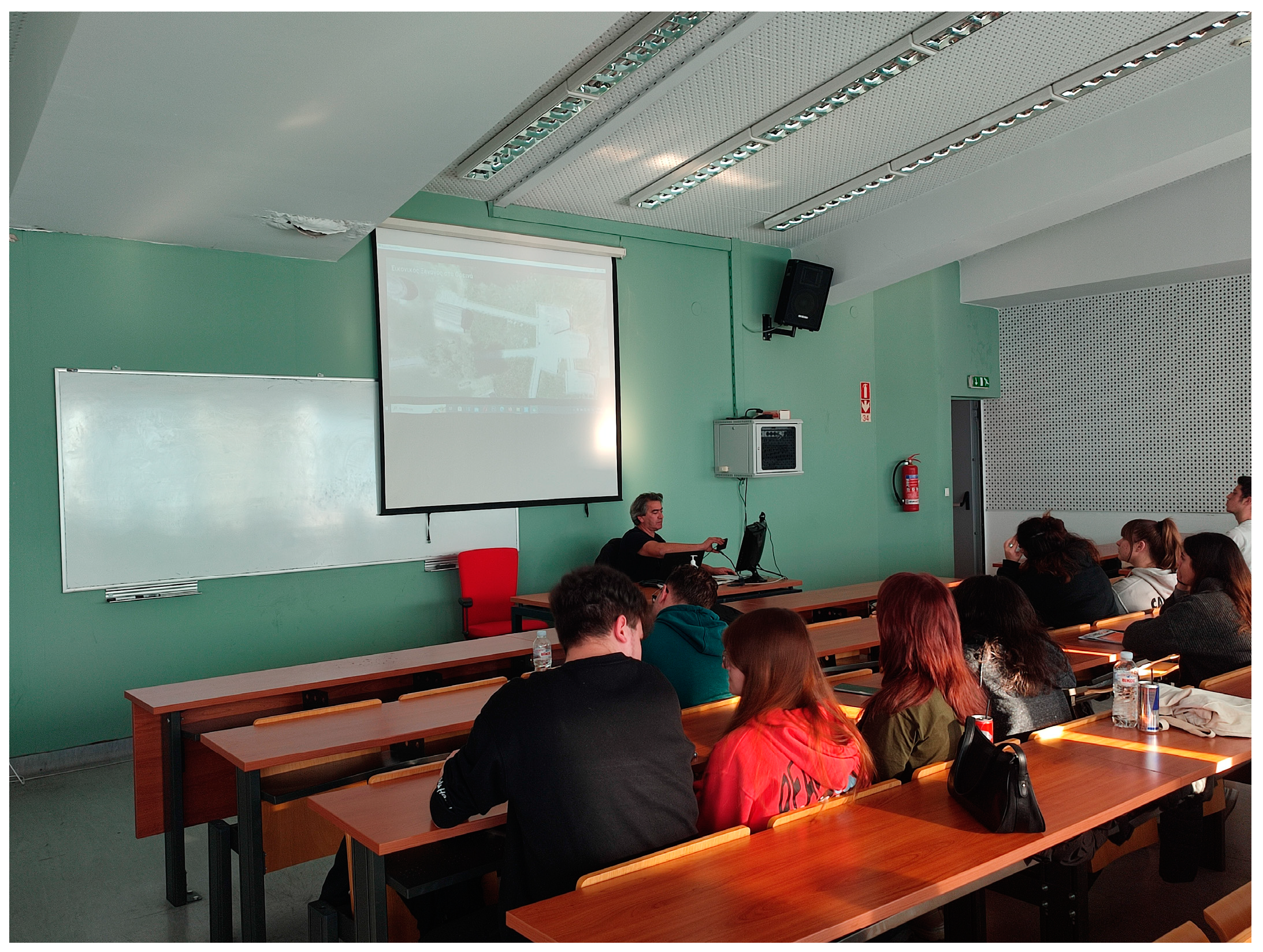
The presentation took place in class, where a mobile phone was connected to a computer and, with the use of a projector, the students were able to see the application (Figure 33). Printouts were also made of the image-markers (street signs that activate the AR experience) so that the students could see what happens when image AR spots were activated (Figure 34). Location-based AR points were also placed nearby, and we made sure that these could be activated during the demonstration in class.
After the demonstration, the students evaluated the application by filling out the questionnaire. Questionnaires were anonymous, and the students were briefed about the research being conducted. A discussion also took place after the demonstration. Students were asked to provide ideas on how to exploit certain application features, such as the markerless AR or the VR portal, in different contexts. Nine students also volunteered to download, install, and test the features of the application by visiting locations in the city of Kastoria and then participating in a quick interview. Some insights and ideas from the discussion that took place in the class and the student interviews will be discussed in the next section.
In Table 1, the mean values of the Likert-Scale items of the questionnaire are presented.
7. Discussion
7.1. Design Decisions
As mentioned in the introduction, the study aims to present a mobile application containing many features to inform and inspire researchers and other professionals interested in developing AR applications for tourism. In order to decide on the appropriate features, the following actions took place:
- The capabilities provided by the Google Android and ARcore SDKs were thoroughly explored.
- Relevant research articles, case studies, and software applications were investigated, and some of these are mentioned in the “Related Work” section.
The application user interface contains navigational features, and all known types of AR. Navigation takes place in two different ways (interactive map and PoI list), and both ways utilize the Google Map service to guide users to their destination. Navigation with the help of the Google Map service is a typical feature in mobile location-based applications. Some features, such as “Location Sharing”, and “Street-view”, are also present in mobile applications. Location sharing may be useful in cases where users want to inform their friends and family about an interesting place they come across during their trip. Street-view is a popular feature in Google Earth that may be useful prior to visiting a place. The users can use this feature to obtain an idea of what they will see once they reach a destination. Furthermore, with the “Favorites” and the “multipoint route” feature, users can personalize their trip by selecting only the places they want to see and navigating to these places.
Regarding the AR capabilities, the authors of this paper were inspired by good examples from the literature (e.g., Rexplorer [30] and Ulocking Porto [33]), as well as known commercial applications (e.g., Civilizations [8]). Most of these studies, however, rarely use more than one type of AR (e.g., Civilizations uses markerless AR while the Rexplorer and Ulocking Porto apps use location-based AR). In the described application, all three known types of AR (marker-based, markerless, and location-based) are present in order to support different experiences.
Markerless AR can be useful when the users operate the application from their home and wish to bring virtual characters and objects to their own space (e.g., on surfaces such as the floor or a table). When they travel to the places of interest, however, location-based AR is more appropriate for activating content that needs to be associated with specific locations. Marker-based AR can be useful in both cases. It can be activated with street signs or other images that the users encounter outdoors during their trip (this is how it is used in this application) or with images that can be provided to the users in other forms (e.g., a tourist book guide).
7.2. Evaluation Findings
As can be seen from the mean values of the answers to the questionnaire, most features were well received. The navigation options of the application and the GPS navigation capabilities of the application, as well as the multi-route option, received among the highest scores (items 9, 14 and 29). The VR portals also ranked highly amongst the participants’ preferences (items 20 and 23). However, from the answers, it seems that the students were not particularly motivated to use the application. It should be noted, however, that most of the participants were first-year students (in their first semester), and there are differences in the answers provided by the smaller sub-sample of students who were in their fifth semester, who were much more willing to use and test the application. The reasons for the attitude found amongst the younger students need to be further explored, and it is not safe to jump to any conclusions without further research. However, one of the limitations of this evaluation is that the results cannot be generalized, and are specific to the participant sample used. As mentioned, the sample consisted of students, most of whom were students in their first year. Therefore, the results may be age-biased and possibly education-level-biased, and the evaluation can only provide a sense of the level of acceptance of the available features. A larger sample, which is more representative of the whole population, would be needed in order to obtain more accurate evaluation results for the application features.
During the talk that took place after the demonstration, some students expressed the need for an IOS version of the application, since many young people in Greece have Apple mobile phones, and one of them expressed the need for a user-interface design that is more appropriate for their age.
An interesting idea was also expressed regarding the VR portals, and their use to immerse the visitor into periods of the year during which special events take place in the city of Kastoria (or the mountainous destinations of Western Macedonia). More specifically, the idea mentioned events that are related to the tradition of the area, such as the Carnival of Kastoria or a period in February where large fires are lit in the squares of Kastoria, called “Boubounes”, a pro-Christian custom.
As mentioned, a small sample of nine students (mainly from the fifth semester) installed and experienced the application by visiting places of interest in the city of Kastoria. They mentioned that navigating to places with the application was very easy, and most marker-based AR spots and location-based AR spots were activated with no problems. The students who volunteered to experience the application were also asked to send us snapshots (or videos) of the augmentations that showed up on the screens of their mobile phones, and some of these screenshots are used in this paper (e.g., Figure 21). Some students mentioned problems with the physical objects used as image triggers (such as the door in the Byzantine Wall), while others expressed problems with image-based AR during nighttime. It was explained to them that image triggers may not work properly in low-light conditions, which is why the option of location-based AR is also present at these places.
8. Conclusions
This study aimed to present a mobile, location-based application for tourism that combined all known types of AR (marker-based, markerless and location-based AR), together with many features that can help the user navigate to places of interest and become informed about these places. The authors of the paper anticipate that, by presenting this broad range of features, ideas will be provided to those wishing to create AR applications for tourism.
Technical information is also provided regarding the design and development of the application. The application underwent a usability test to check its functionality, and a sample of participants evaluated the application features. For the evaluation, the application was first presented to the participants, and then their perceptions regarding the application features were recorded using a Likert-scale questionnaire. Overall, the application features were well accepted by the participants who took place in the evaluation. Furthermore, a discussion took place to give the participants the chance to express their views freely and to provide ideas about alternative uses of the present features and other possible ways of improving the application.
The evaluation gave the research team a sense of the level of acceptance of the available features, and interesting ideas were expressed in the discussion, which will be considered for future application upgrades. Furthermore, a small number of participants downloaded, installed, and used the application. These participants visited places of interest with the aid of the application and experienced the types of AR that are present in the application. By interviewing these participants, it became evident that the application ran smoothly in most cases, and participants were impressed by the AR features.
Author Contributions
Conceptualization, A.E., A.K. and G.L; methodology, A.K. and A.E.; software, A.E.; validation, A.K. and G.L.; investigation, A.E.; resources, A.E.; data curation, A.K.; writing—original draft preparation, A.K., A.E. and G.L.; writing—review and editing, A.K. and A.E.; project administration, G.L. and A.K.; All authors have read and agreed to the published version of the manuscript.
Funding
This research received no external funding.
Data Availability Statement
Data available on request due to privacy restrictions.
Conflicts of Interest
The authors declare no conflict of interest.
References
- Azuma, R.T. A Survey of Augmented Reality. Presence Teleoperators Virtual Environ. 1997, 6, 355–385. [Google Scholar] [CrossRef]
- FitzGerald, E.; Ferguson, R.; Adams, A.; Gaved, M.; Mor, Y.; Thomas, R. Augmented Reality and Mobile Learning: The State of the Art. Int. J. Mob. Blended Learn. 2013, 5, 43–58. [Google Scholar] [CrossRef]
- Dunleavy, M.; Dede, C. Augmented Reality Teaching and Learning. In Handbook of Research on Educational Communications and Technology; Spector, J.M., Merrill, M.D., Elen, J., Bishop, M.J., Eds.; Springer: New York, NY, USA, 2014; pp. 735–745. ISBN 978-1-4614-3184-8. [Google Scholar]
- Klopfer, E. Augmented Learning: Research and Design of Mobile Educational Games; MIT Press: Cambridge, MA, USA, 2008; ISBN 978-0-262-11315-1. [Google Scholar]
- Peddie, J. Types of Augmented Reality. In Augmented Reality; Springer International Publishing: Cham, Switzerland, 2017; pp. 29–46. ISBN 978-3-319-54501-1. [Google Scholar]
- Loureiro, S.M.C.; Guerreiro, J.; Ali, F. 20 Years of Research on Virtual Reality and Augmented Reality in Tourism Context: A Text-Mining Approach. Tour. Manag. 2020, 77, 104028. [Google Scholar] [CrossRef]
- Launch of New IKEA Place App—IKEA Global. Available online: https://www.ikea.com/global/en/newsroom/innovation/ikea-launches-ikea-place-a-new-app-that-allows-people-to-virtually-place-furniture-in-their-home-170912/ (accessed on 21 December 2023).
- BBC News. BBC Launches Augmented Reality App for Civilisations; BBC News: London, UK, 2018. [Google Scholar]
- Neuhofer, B.; Buhalis, D.; Ladkin, A. A Typology of Technology-Enhanced Tourism Experiences. Int. J. Tour. Res. 2014, 16, 340–350. [Google Scholar] [CrossRef]
- Yung, R.; Khoo-Lattimore, C. New Realities: A Systematic Literature Review on Virtual Reality and Augmented Reality in Tourism Research. Curr. Issues Tour. 2019, 22, 2056–2081. [Google Scholar] [CrossRef]
- Chu, T.-H.; Lin, M.-L.; Chang, C.-H. mGuiding (Mobile Guiding)—Using a Mobile GIS App for Guiding. Scand. J. Hosp. Tour. 2012, 12, 269–283. [Google Scholar] [CrossRef]
- Dueholm, J.; Smed, K.M. Heritage Authenticities—A Case Study of Authenticity Perceptions at a Danish Heritage Site. J. Herit. Tour. 2014, 9, 285–298. [Google Scholar] [CrossRef]
- Jung, T.; Chung, N.; Leue, M.C. The Determinants of Recommendations to Use Augmented Reality Technologies: The Case of a Korean Theme Park. Tour. Manag. 2015, 49, 75–86. [Google Scholar] [CrossRef]
- Lalicic, L.; Weismayer, C. The Passionate Use of Mobiles Phones among Tourists. Inf. Technol. Tour. 2016, 16, 153–173. [Google Scholar] [CrossRef]
- Mésároš, P.; Mandičák, T.; Mesarosova, A.; Hernandez, M.F.; Kršák, B.; Sidor, C.; Strba, L.; Molokáč, M.; Hvizdák, L.; Blistan, P.; et al. Use of Augmented Reality and Gamification Techniques in Tourism. E Rev. Tour. Res. 2016, 13, 366–381. [Google Scholar]
- tom Dieck, M.C.; Jung, T.; Han, D.-I. Mapping Requirements for the Wearable Smart Glasses Augmented Reality Museum Application. J. Hosp. Tour. Technol. 2016, 7, 230–253. [Google Scholar] [CrossRef]
- Trojan, J. Integrating AR Services for the Masses: Geotagged POI Transformation Platform. J. Hosp. Tour. Technol. 2016, 7, 254–265. [Google Scholar] [CrossRef]
- tom Dieck, M.C.; Jung, T. A Theoretical Model of Mobile Augmented Reality Acceptance in Urban Heritage Tourism. Curr. Issues Tour. 2018, 21, 154–174. [Google Scholar] [CrossRef]
- Jung, T.; Dieck, M.T.; Lee, H.; Chung, N. The Moderating Effect of Long-Term Orientation on Experience Economy in Augmented Reality Adoption. In Proceedings of the EuroCHRIE 2015, Manchester, UK, 15–17 October 2015. [Google Scholar]
- Jingen Liang, L.; Elliot, S. A Systematic Review of Augmented Reality Tourism Research: What Is Now and What Is Next? Tour. Hosp. Res. 2021, 21, 15–30. [Google Scholar] [CrossRef]
- Fan, X.; Jiang, X.; Deng, N. Immersive Technology: A Meta-Analysis of Augmented/Virtual Reality Applications and Their Impact on Tourism Experience. Tour. Manag. 2022, 91, 104534. [Google Scholar] [CrossRef]
- Champion, E. Critical Gaming: Interactive History and Virtual Heritage; Routledge: London, UK, 2016; ISBN 978-1-315-57498-1. [Google Scholar]
- Xu, F.; Tian, F.; Buhalis, D.; Weber, J.; Zhang, H. Tourists as Mobile Gamers: Gamification for Tourism Marketing. J. Travel Tour. Mark. 2016, 33, 1124–1142. [Google Scholar] [CrossRef]
- Cauchi, M.; Scerri, D. Enriching Tourist UX via a Location Based AR Treasure Hunt Game. In Proceedings of the 2019 IEEE 9th International Conference on Consumer Electronics (ICCE-Berlin), Berlin, Germany, 8–11 September 2019; pp. 199–204. [Google Scholar]
- Kleftodimos, A.; Moustaka, M.; Evagelou, A. Location-Based Augmented Reality for Cultural Heritage Education: Creating Educational, Gamified Location-Based AR Applications for the Prehistoric Lake Settlement of Dispilio. Digital 2023, 3, 18–45. [Google Scholar] [CrossRef]
- Kleftodimos, A.; Evagelou, A.; Triantafyllidou, A.; Grigoriou, M.; Lappas, G. Location-Based Augmented Reality for Cultural Heritage Communication and Education: The Doltso District Application. Sensors 2023, 23, 4963. [Google Scholar] [CrossRef]
- Kleftodimos, A.; Evagelou, A.; Gkoutzios, S.; Matsiola, M.; Vrigkas, M.; Yannacopoulou, A.; Triantafillidou, A.; Lappas, G. Creating Location-Based Augmented Reality Games and Immersive Experiences for Touristic Destination Marketing and Education. Computers 2023, 12, 227. [Google Scholar] [CrossRef]
- Mandler, J.M. Stories, Scripts, and Scenes; Psychology Press: London, UK, 2014; ISBN 978-1-317-76859-3. [Google Scholar]
- Azuma, R. Location-Based Mixed and Augmented Reality Storytelling. In Fundamentals of Wearable Computers and Augmented Reality, 2nd ed.; CRC Press: Boca Raton, FL, USA, 2015; pp. 259–276. ISBN 978-1-4822-4350-5. [Google Scholar]
- Ballagas, R.A.; Kratz, S.G.; Borchers, J.; Yu, E.; Walz, S.P.; Fuhr, C.O.; Hovestadt, L.; Tann, M. REXplorer: A Mobile, Pervasive Spell-Casting Game for Tourists. In Proceedings of the CHI ’07 Extended Abstracts on Human Factors in Computing Systems, San Jose, CA, USA, 28 April–3 May 2007; ACM Press: New York, NY, USA; pp. 1929–1934. [Google Scholar]
- Spierling, U.; Winzer, P.; Massarczyk, E. Experiencing the Presence of Historical Stories with Location-Based Augmented Reality. In Interactive Storytelling; Nunes, N., Oakley, I., Nisi, V., Eds.; Lecture Notes in Computer Science; Springer International Publishing: Cham, Switzerland, 2017; Volume 10690, pp. 49–62. ISBN 978-3-319-71026-6. [Google Scholar]
- Naliuka, K.; Carrigy, T.; Paterson, N.; Haahr, M. A Narrative Architecture for Story-Driven Location-Based Mobile Games. In New Horizons in Web-Based Learning—ICWL 2010 Workshops; Luo, X., Cao, Y., Yang, B., Liu, J., Ye, F., Eds.; Lecture Notes in Computer Science; Springer: Berlin/Heidelberg, Germany, 2011; Volume 6537, pp. 11–20. ISBN 978-3-642-20538-5. [Google Scholar]
- Nobrega, R.; Jacob, J.; Coelho, A.; Weber, J.; Ribeiro, J.; Ferreira, S. Mobile Location-Based Augmented Reality Applications for Urban Tourism Storytelling. In Proceedings of the 2017 24° Encontro Português de Computação Gráfica e Interação (EPCGI), Guimaraes, Portugal, 12–13 October 2017; IEEE: Piscataway, NJ, USA, 2017; pp. 1–8. [Google Scholar]
- Vert, S.; Andone, D.; Ternauciuc, A.; Mihaescu, V.; Rotaru, O.; Mocofan, M.; Orhei, C.; Vasiu, R. User Evaluation of a Multi-Platform Digital Storytelling Concept for Cultural Heritage. Mathematics 2021, 9, 2678. [Google Scholar] [CrossRef]
- De Paolis, L.T.; Gatto, C.; Corchia, L.; De Luca, V. Usability, User Experience and Mental Workload in a Mobile Augmented Reality Application for Digital Storytelling in Cultural Heritage. Virtual Real. 2023, 27, 1117–1143. [Google Scholar] [CrossRef]
- Lent, B.; Marciniak, M. Enhancing Tourism Potential by Using Gamification Techniques and Augmented Reality in Mobile Games. In Proceedings of the 34th International Business Information Management Association Conference (IBIMA), Madrid, Spain, 13–14 November 2020. [Google Scholar]
- Silva, R.; Jesus, R.; Jorge, P. Development and Evaluation of a Mobile Application with Augmented Reality for Guiding Visitors on Hiking Trails. Multimodal Technol. Interact. 2023, 7, 58. [Google Scholar] [CrossRef]
- Cisternino, D.; Gatto, C.; D’Errico, G.; De Luca, V.; Barba, M.C.; Paladini, G.I.; De Paolis, L.T. Virtual Portals for a Smart Fruition of Historical and Archaeological Contexts. In Augmented Reality, Virtual Reality, and Computer Graphics; De Paolis, L.T., Bourdot, P., Eds.; Lecture Notes in Computer Science; Springer International Publishing: Cham, Switzerland, 2019; Volume 11614, pp. 264–273. ISBN 978-3-030-25998-3. [Google Scholar]
- Nielsen, J. Usability Engineering; Elsevier: Amsterdam, The Netherlands, 1993; ISBN 978-0-12-518406-9. [Google Scholar]
- St. Stephen’ s College; Gupta, S. A Comparative Study of Usability Evaluation Methods. Int. J. Comput. Trends Technol. 2015, 22, 103–106. [Google Scholar] [CrossRef]
Figure 1.
Initial menu of options presented by the Virtual Guide for the mountainous regions of Western Macedonia and the city of Kastoria.
Figure 1.
Initial menu of options presented by the Virtual Guide for the mountainous regions of Western Macedonia and the city of Kastoria.

Figure 2.
Interactive map and PoI list options.

Figure 3.
Interactive map.

Figure 4.
PoI list options.

Figure 5.
Information about the Points of Interest.

Figure 6.
Images, map, and tabs to explore, navigate and obtain a street view of the place.

Figure 7.
Nimfeo village street view.

Figure 8.
360° view from the house of Pavlos Melas, which operates as a museum.

Figure 9.
Navigation with Google Map API.

Figure 10.
Multipoint route option.

Figure 11.
The “Favorites” option.

Figure 12.
(a) Location sharing menu item, (b) sharing a location.

Figure 13.
(a–c) Interactive map, PoI list and information.

Figure 14.
Augmentation of the mythical figure of “Callisto”. The mythical figure appears when an informational street sign is scanned with the camera of a mobile phone. The sign lists points of interest in the village of Nimfeo and nearby hotels.
Figure 14.
Augmentation of the mythical figure of “Callisto”. The mythical figure appears when an informational street sign is scanned with the camera of a mobile phone. The sign lists points of interest in the village of Nimfeo and nearby hotels.

Figure 15.
The dragon at the entrance of the Dragon’s cave, narrating the story of the cave.

Figure 16.
Christopoulos reciting one of his famous poems.

Figure 17.
Dragoumis narrating excerpts from his memoirs. The virtual character appears after scanning the street sign for the village of Vogatsiko.
Figure 17.
Dragoumis narrating excerpts from his memoirs. The virtual character appears after scanning the street sign for the village of Vogatsiko.

Figure 18.
Pavlos Melas reading a letter that he sent to his parents.

Figure 19.
Farmakis narrates the details of a battle that took place in the area of Vlasti.

Figure 20.
Augmented experience using a video that was shot 100 years ago.

Figure 21.
Transparent video of a virtual guide providing information about the Byzantine wall. The virtual guide also prompts the user to turn the camera right and left in order to see an interactive map of the wall (right) and a link to a webpage with more information (left).
Figure 21.
Transparent video of a virtual guide providing information about the Byzantine wall. The virtual guide also prompts the user to turn the camera right and left in order to see an interactive map of the wall (right) and a link to a webpage with more information (left).

Figure 22.
Virtual guide delivering information about the Department of Communication and Digital Media.
Figure 22.
Virtual guide delivering information about the Department of Communication and Digital Media.

Figure 23.
3D model of the Koumpelidiki byzantine church.

Figure 24.
The mythical dragon of the cave.

Figure 25.
A VR portal that brings the Aquarium of Kastoria into the users’ space. (a) The VR portal sphere appears in the users space (b) a 360o panoramic image appears when the user enters the sphere.
Figure 25.
A VR portal that brings the Aquarium of Kastoria into the users’ space. (a) The VR portal sphere appears in the users space (b) a 360o panoramic image appears when the user enters the sphere.

Figure 26.
Activating location-based AR by clicking on the pin icon.

Figure 27.
Location-based AR activation.

Figure 28.
Location-based augmentation showing video footage captured with an underwater drone.

Figure 29.
VR portal in the form of a “Magic Ball”.

Figure 30.
VR portal transfer to a bird’s view.

Figure 31.
Application’s functionality.

Figure 32.
Gender.

Figure 33.
Demonstrating the application in class.

Figure 34.
Demonstrating the application in class. Activating a marker-based augmentation.


Table 1.
Mean values of the Likert-scale items.
| No | Questionnaire Item | Mean | StdDev | Median | Max | Min |
|---|---|---|---|---|---|---|
| 1 | The interaction with the application “Virtual Guide in the mountains of Western Macedonia and the city of Kastoria” is easy and understandable. | 4.3 | 0.6 | 4 | 5 | 3 |
| 2 | The application seems easy and user-friendly. | 4.0 | 0.9 | 4 | 5 | 2 |
| 3 | The application would motivate me to explore new places. | 3.7 | 1.0 | 4 | 5 | 2 |
| 4 | The application would be an opportunity to get out of my house and travel in the region of Western Macedonia. | 3.4 | 1.1 | 3 | 5 | 1 |
| 5 | I think the application is fun | 3.5 | 0.9 | 3 | 5 | 2 |
| 6 | The information (photos and description) available for each point of interest is useful. | 4.2 | 0.8 | 4 | 5 | 3 |
| 7 | The information (photos and description) that exists for each point of interest motivates me to visit the place. | 3.7 | 1.0 | 4 | 5 | 1 |
| 8 | I find the information (altitude, distance, address, telephone, email, relevant web-site and video) that exists for each point of interest useful. | 4.3 | 0.9 | 4,5 | 5 | 2 |
| 9 | The navigation feature makes it easier for me to visit the points of interest. | 4.4 | 0.9 | 5 | 5 | 1 |
| 10 | The street view feature is interesting. | 4.2 | 0.8 | 4 | 5 | 2 |
| 11 | The street view feature acts as an incentive to visit the points of interest. | 3.1 | 1.0 | 3 | 5 | 1 |
| 12 | I find the audio narration of the description for all points of interest feature interesting. | 4.1 | 1.0 | 4 | 5 | 2 |
| 13 | I like the feature that allows me to create a list of favorite points of interest. | 4.1 | 1.0 | 4 | 5 | 1 |
| 14 | I find the feature of the interactive map with GPS navigation capability for all points of interest interesting. | 4.4 | 0.8 | 5 | 5 | 2 |
| 15 | I find it helpful to share my location (Location Sharing) | 4.1 | 0.9 | 4 | 5 | 2 |
| 16 | The possibility of an enhanced experience through marker-based (image scanning) motivates me to visit a point of interest. | 3.5 | 1.2 | 4 | 5 | 1 |
| 17 | I had positive feelings about my augmented experience (AI virtual guide, transparent video, 3d model, audiobook and extra information) through marker-based AR. | 4.1 | 1.0 | 4 | 5 | 2 |
| 18 | I had positive feelings about my augmented experience (AI virtual guide, transparent video, 3d model, audiobook and extra information) through location-based AR. | 3.9 | 0.8 | 4 | 5 | 2 |
| 19 | Markerless AR could be used educationally. | 4.2 | 0.8 | 4 | 5 | 3 |
| 20 | VR Portals (360° Virtual Spaces in Augmented Reality) could be used for educational purposes. | 4.3 | 0.8 | 4 | 5 | 2 |
| 21 | I find very interesting the 3D virtual talking characters (e.g., Pavlos Melas, Ion Dragoumis, Mythical Figures, etc.) | 3.9 | 1.0 | 4 | 5 | 1 |
| 22 | I find augmentations with transparent videos very interesting | 3.9 | 1.0 | 4 | 5 | 1 |
| 23 | I find VR Portals very interesting (“magical” spheres -360° photo in Augmented Reality). | 4.2 | 0.9 | 4 | 5 | 2 |
| 24 | I think that the application “Virtual Guide in the mountains of Western Macedonia and the city of Kastoria” would improve my knowledge of the natural and cultural heritage of Western Macedonia | 4.0 | 1.0 | 4 | 5 | 1 |
| 25 | I plan to use the application | 3.4 | 1.1 | 3 | 5 | 1 |
| 26 | I would like there to be other similar applications both for Kastoria and Western Macedonia as well as for other parts of Greece. | 4.2 | 0.9 | 4 | 5 | 2 |
| 27 | I would like to use similar applications in the future for another region of Greece. | 4.1 | 1.0 | 4 | 5 | 2 |
| 28 | The option to be guided to a hiking path (Kastoria—Psalida trail) using an interactive map is interesting. | 3.8 | 1.0 | 4 | 5 | 2 |
| 29 | An application with many route-paths embedded on an interactive map would be useful. | 4.3 | 1.0 | 5 | 5 | 2 |
Disclaimer/Publisher’s Note: The statements, opinions and data contained in all publications are solely those of the individual author(s) and contributor(s) and not of MDPI and/or the editor(s). MDPI and/or the editor(s) disclaim responsibility for any injury to people or property resulting from any ideas, methods, instructions or products referred to in the content. |
© 2024 by the authors. Licensee MDPI, Basel, Switzerland. This article is an open access article distributed under the terms and conditions of the Creative Commons Attribution (CC BY) license (https://creativecommons.org/licenses/by/4.0/).
Share and Cite
MDPI and ACS Style
Evagelou, A.; Kleftodimos, A.; Lappas, G. Creating Location-Based Mobile Applications for Tourism: A Virtual AR Guide for Western Macedonia. Digital 2024, 4, 271-301. https://doi.org/10.3390/digital4010014
AMA Style
Evagelou A, Kleftodimos A, Lappas G. Creating Location-Based Mobile Applications for Tourism: A Virtual AR Guide for Western Macedonia. Digital. 2024; 4(1):271-301. https://doi.org/10.3390/digital4010014
Chicago/Turabian StyleEvagelou, Athanasios, Alexandros Kleftodimos, and Georgios Lappas. 2024. "Creating Location-Based Mobile Applications for Tourism: A Virtual AR Guide for Western Macedonia" Digital 4, no. 1: 271-301. https://doi.org/10.3390/digital4010014