1. Introduction
Landslides are complex geological phenomena whose activation mechanisms differ significantly from region to region and over time [
1]. Their complexity, coupled with their typically devastating consequences, has stimulated scientific interest in developing accurate and reliable techniques for rapidly identifying and assessing the most vulnerable subregions facing the highest landslide risk. This assessment is crucial as it enables stakeholders to apply efficient and spatially focused protective measures, thus reducing the impact of landslides in the case of potential activation.
Many scientific research studies employ multi-criteria decision analysis methods (MCDA) [
2,
3,
4] to identify the most susceptible subregions within an area due to their efficiency and rapid applicability [
5]. In these studies, the availability of a comprehensive landslides inventory is essential as it can be used either during the application of the method or during the evaluation of its effectiveness. More specifically, in an MCDA method, a landslides inventory is usually used for the identification of the most critical causal factors and the evaluation of their relative contribution (weight) (e.g., during the frequency ratio (FR) method). In such cases, the inventory must include the maximum possible of the landslides occurred in the Area of Interest (AOI) as this parameter directly impacts the efficacy of the applied method.
Moreover, a complete landslides inventory is crucial in studies that evaluate the intensity duration (ID) precipitation activation thresholds of an area [
6]. Evaluating these thresholds requires information about the temporal characteristics of the landslides, as well as their spatial characteristics. This includes details such as the exact date of their activation and the duration of the accumulated precipitation that led to these activations [
6].
In some countries, a national landslides inventory does not exist, despite the frequent occurrence of intense landslides that result in many fatalities and the destruction of critical infrastructure [
1]. In such cases, scientists often attempt to create a landslides inventory based on open access landslides geodatabases, such as the Global Landslide Catalogue (GLC) [
7], and remote sensing techniques, such as differential interferometric synthetic aperture radar (DInSAR) methods [
8]. However, the level of detail and completeness of these inventories is often low due to two main reasons. Firstly, some geodatabases are spatially based, primarily containing landslides activated close to residential areas and critical infrastructure, including only a small number of landslides activated in remote or difficult-to-access areas. Secondly, using remote sensing techniques alone does not automatically lead to a complete landslides inventory. It also requires additional data on other landslide characteristics, such as the exact date of activation and the prevailing causal factors.
The object of this study is to develop a framework that integrates a DInSAR method with existing methodologies and open access data to establish a comprehensive landslides inventory. The proposed framework was applied in the Chania regional unit in western Crete, Greece, which was selected as the case study area.
2. Data and Methods
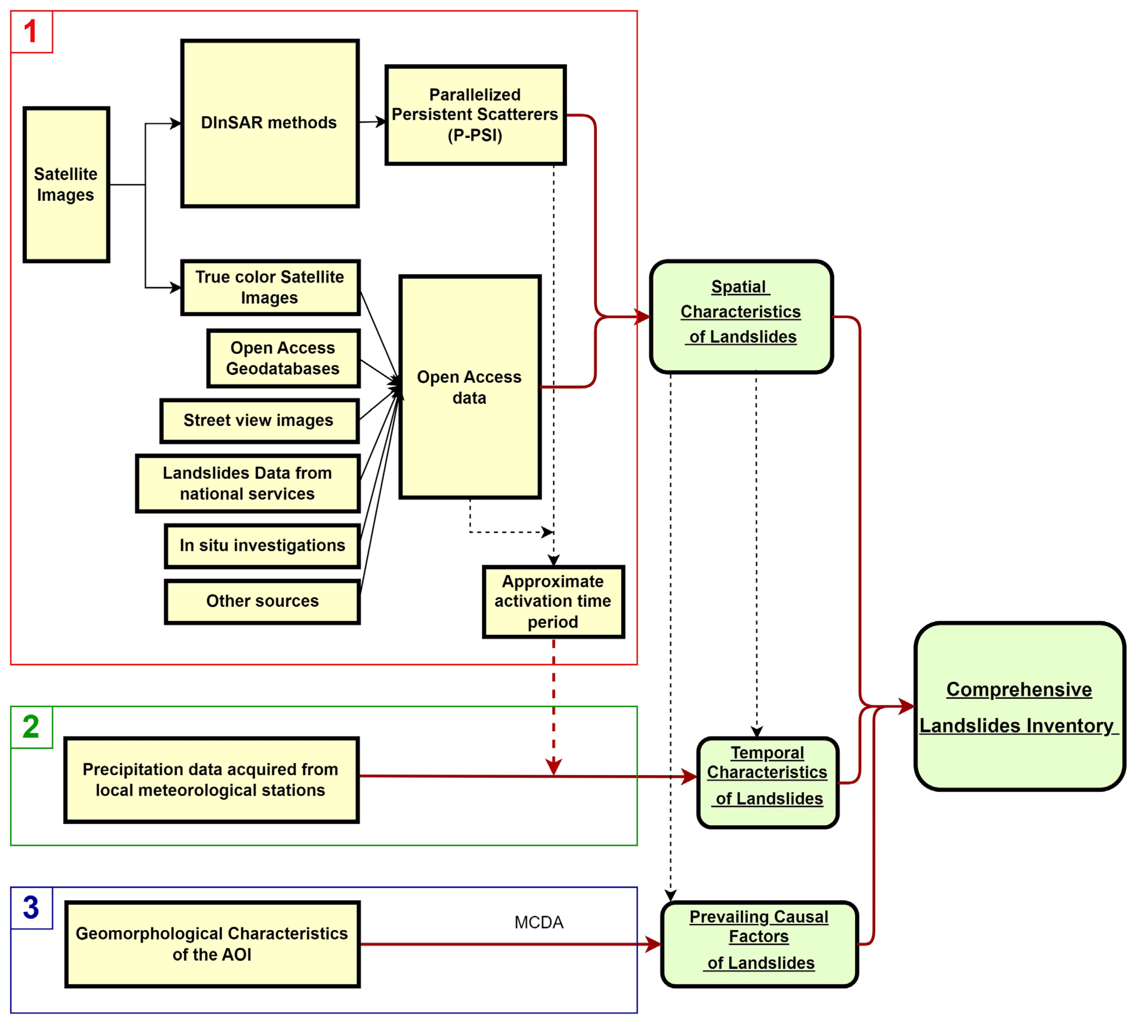
The methodological framework proposed by this study is depicted in
Figure 1. As shown, in order to create a complete landslides inventory, the spatial and temporal characteristics of the landslides were combined with the prevailing factors that triggered their activation. The framework consists of three main steps.
In the first step, which is symbolized with number 1 in
Figure 1, the spatial characteristics of the landslides, such as their location, orientation, and extent, are determined by employing the Parallelized Persistent Scatterer Interferometry (P-PSI) method, which can speed up the whole process by a factor of five [
8]. A detailed analysis of the processing of Sentinel-1 images with the P-PSI method for landslide evaluation and monitoring is provided by [
8,
9]. The results from the P-PSI method are then further combined with open access data, specifically focusing on each identified landslide. These data sources include true-color satellite images, open access geodatabases, street view images, landslide data from national services, in situ investigations, and other sources, such as studies, technical reports, newspapers, and social media.
Besides the identification and verification of the landslides, open access data also contribute to the estimation of the approximate time of the landslides’ activation. However, the exact date is determined in the second step, as shown in
Figure 1, by using the precipitation records from a dense network of meteorological stations. These data are used to evaluate the precise date of activation of each landslide.
In the third step, number 3 in
Figure 1, an MCDA method is applied using the identified location of each recorded landslide and the geomorphological characteristics of the AOI in a GIS environment. Thus, the causal factors for each landslide are evaluated and integrated into the resulting landslides inventory.
3. Results
The proposed framework was applied to the Chania regional unit, Crete Island, Greece, to analytically present each individual step and highlight its applicability. The outcomes of each step are analyzed in the following paragraphs.
3.1. Spatial Characteristics of the Landslides
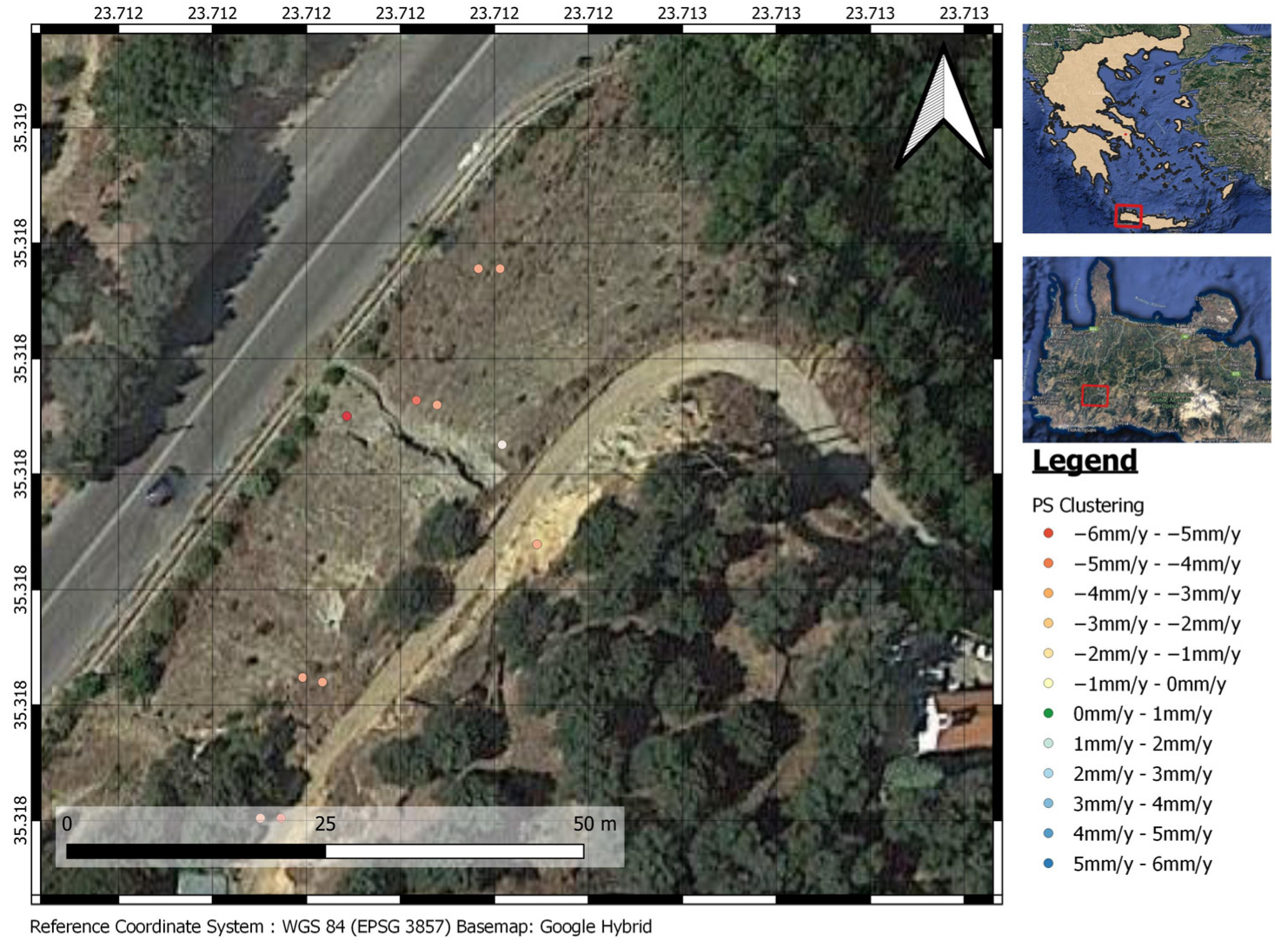
By using Sentinel-1 satellite images and the P-PSI technique, 290,000 Permanent Scatterers (PSs) were identified for the ascending orbit and 380,000 PSs for the descending orbit in the AOI. Based on the resulting PSs Line of Sight (LOS) displacements and the visual data acquired for these locations, 236 new landslides were identified. For instance, as illustrated in
Figure 2, based on LOS displacements in the Kandanos region, a landslide was initially identified. It must be noted that
Figure 2 illustrates a specific and limited region of the AOI, where only a few PS were identified. Therefore, it depicts only the relative classes of these particular PS, as resulted by the PS clustering. However, the legend of the figure encompasses the PS classification, using the red, green blue (RGB) color range, which was followed across the entire AOI. Subsequently, as shown in
Figure 3, the landslide was verified using Google Earth historical images and street view images. Additionally, an approximate time range for the landslide’s activation was established.
Figure 2 provides an example in which satellite images were combined with visual data to identify and document a landslide along the road network connecting Kandanos village with Grigoriana village within the AOI.
3.2. Temporal Characteristics of the Landslides
After assessing the approximate time frame of a landslide’s activation, the determination of the exact date ensues. In the examined landslide depicted in
Figure 2 and
Figure 3, technical reports from the Hellenic Survey of Geology and Mineral Exploration (HSGME) and the precipitation values from the meteorological stations of the National Observatory of Athens (NOA) were used to determine that this landslide was activated on 24–26 February 2019.
3.3. Assessment of the Prevailing Causal Factors of the Landslides
As illustrated in
Figure 1, after the geographic location of a landslide event has been determined using the procedure described in the previous step, an MCDA method must be applied to assess the geomorphological factors that led to the activation of the landslide. In our case, the Analytical Hierarchy Process (AHP) method was applied, and we identified the following as the most critical causal factors: mean annual precipitation, lithology, land use/land cover (LU/LC), distance from road network, distance from stream network, slope angle, slope aspect, and relative relief.
4. Discussion
As demonstrated, the proposed framework has proven to be highly effective as it has led to the creation of a comprehensive landslides inventory, which includes 236 landslides in the AOI. The newly identified landslides are illustrated in
Figure 4.
This is very significant, especially in countries like Greece, where a landslides inventory does not exist. Furthermore, this inventory can lead to a rapid assessment of the landslide susceptibility of the AOI, as it also includes the application of an MCDA method as the last step of the process. Based on the identified landslides and the landslide susceptibility derived by applying the proposed framework, stakeholders can make well-informed decisions regarding the adoption and implementation of appropriate measures in the subregions that face the highest landslide susceptibility. Furthermore, the evaluation of the geomorphological characteristics that activated the landslides helps scientists determine the kind of measures required to mitigate their impact.
5. Conclusions
Creating a comprehensive landslides inventory can be a rather difficult and demanding procedure. The recommended framework provides a guide that can facilitate and standardize the whole process, as it can lead to the rapid and efficient identification of the spatial and temporal characteristics of landslides in the AOI, along with their causal factors. Thus, this contributes to the establishment of a complete landslide inventory, even on extended and difficult to reach areas. The application of the framework to the Chania regional unit highlighted its effectiveness, resulting in the identification of 236 new landslides.
Author Contributions
Conceptualization, C.N. and C.L.; methodology, C.N.; software, C.N. and S.A.; validation, C.N. and C.L.; formal analysis, C.N.; investigation, C.N.; resources, C.N., S.A. and C.K.; data curation, C.N.; writing—original draft preparation, C.N.; writing—review and editing, C.N. and C.L.; visualization, C.L. and C.K.; supervision, C.L. and C.K.; project administration, C.N. All authors have read and agreed to the published version of the manuscript.
Funding
This research received no external funding.
Data Availability Statement
The data used to support the findings of this study are available from the corresponding author upon reasonable request.
Acknowledgments
Sentinel-1 images were processed with the P-PSI processing chain in the Operational Unit BEYOND Centre for Earth Observation Research and Satellite Remote Sensing of the Institute for Astronomy, Astrophysics, Space Applications and Remote Sensing of the National Observatory of Athens.
Conflicts of Interest
The authors declare no conflicts of interest.
References
- van Westen, C.J.; van Asch, T.W.J.; Soeters, R. Landslide Hazard and Risk Zonation—Why Is It Still so Difficult? Bull. Eng. Geol. Environ. 2006, 65, 167–184. [Google Scholar] [CrossRef]
- Zhao, H.; Yao, L.; Mei, G.; Liu, T.; Ning, Y. A Fuzzy Comprehensive Evaluation Method Based on AHP and Entropy for a Landslide Susceptibility Map. Entropy 2017, 19, 396. [Google Scholar] [CrossRef]
- Psomiadis, E.; Papazachariou, A.; Soulis, K.; Alexiou, D.-S.; Charalampopoulos, I. Landslide Mapping and Susceptibility Assessment Using Geospatial Analysis and Earth Observation Data. Land 2020, 9, 133. [Google Scholar] [CrossRef]
- Tavoularis, N.; Papathanassiou, G.; Ganas, A.; Argyrakis, P. Development of the Landslide Susceptibility Map of Attica Region, Greece, Based on the Method of Rock Engineering System. Land 2021, 10, 148. [Google Scholar] [CrossRef]
- Psomiadis, E.; Charizopoulos, N.; Efthimiou, N.; Soulis, K.X.; Charalampopoulos, I. Earth Observation and GIS-Based Analysis for Landslide Susceptibility and Risk Assessment. ISPRS Int. J. Geoinf. 2020, 9, 552. [Google Scholar] [CrossRef]
- Lainas, S.; Sabatakakis, N.; Koukis, G. Rainfall thresholds for possible landslide initiation in wildfire-affected areas of western Greece. Bull. Eng. Geol. Environ. 2016, 75, 883–896. [Google Scholar] [CrossRef]
- Kirschbaum, D.; Stanley, T.; Zhou, Y. Spatial and Temporal Analysis of a Global Landslide Catalog. Geomorphology 2015, 249, 4–15. [Google Scholar] [CrossRef]
- Nefros, C.; Alatza, S.; Loupasakis, C.; Kontoes, C. Persistent Scatterer Interferometry (PSI) Technique for the Identification and Monitoring of Critical Landslide Areas in a Regional and Mountainous Road Network. Remote Sens. 2023, 15, 1550. [Google Scholar] [CrossRef]
- Papoutsis, I.; Kontoes, C.; Alatza, S.; Apostolakis, A.; Loupasakis, C. InSAR Greece with Parallelized Persistent Scatterer Interferometry: A National Ground Motion Service for Big Copernicus Sentinel-1 Data. Remote Sens. 2020, 12, 3207. [Google Scholar] [CrossRef]
- Google. Google Street View, Regional Road from Tavronitis to Paleochora. October 2014. Available online: https://maps.app.goo.gl/eXVw9e8CniC93xXs7 (accessed on 6 March 2024).
| Disclaimer/Publisher’s Note: The statements, opinions and data contained in all publications are solely those of the individual author(s) and contributor(s) and not of MDPI and/or the editor(s). MDPI and/or the editor(s) disclaim responsibility for any injury to people or property resulting from any ideas, methods, instructions or products referred to in the content. |
© 2024 by the authors. Licensee MDPI, Basel, Switzerland. This article is an open access article distributed under the terms and conditions of the Creative Commons Attribution (CC BY) license (https://creativecommons.org/licenses/by/4.0/).


