
Towards Modeling of the Landscape Evolution of Los Naranjos Archaeological Site, Honduras †


1
School of Land Surveying, Geodesy and Mapping Engineering, Technical University of Madrid, C/Mercator, 2, 28031 Madrid, Spain
2
Department of Archaeoastronomy and Cultural Astronomy, Space Science Faculty, National Autonomous University of Honduras, Tegucigalpa 11101, Honduras
†
Presented at the IV Conference on Geomatics Engineering, Madrid, Spain, 6–7 July 2023.
Environ. Sci. Proc. 2023, 28(1), 32; https://doi.org/10.3390/environsciproc2023028032
Published: 15 March 2024
(This article belongs to the Proceedings of IV Conference on Geomatics Engineering)
Abstract
:Los Naranjos is an archaeological site inhabited since approximately 800 BC. The objective is to analyze the landscape of this site to understand the territorial, social, and cultural dynamics, along with its natural environment, since pre-Hispanic times. The methodology involves a documentary review of investigations, and a search for mappings and reconstructions of previous studies, historical sources, and fieldwork. Preliminary results include a review of existing sources for model generation.
1. Introduction
The perception of the landscape has gone from a vision of a contemplative landscape to becoming part of the means of interpreting the relationship between communities and their environment. Landscape studies have become more complex as theories, methods, and technologies evolve. The landscape is a social and dynamic construction. Iwaniszewsi affirm it as a product of the relationship between humans and their environment, related to their way of being and living [1]. Nogue states that the landscape is a product of a collective transformation of nature, a cultural projection of society in each space with a dynamic and lively character [2].
According to Criado Boado, the landscape presents physical, social, and symbolic properties; it involves the natural, built, and symbolic environment. The landscape includes a physical environment or environmental matrix of human action, where the landscape takes shape in that environment. A social environment is built by social practices that modify, use, or delimit it. The symbolic medium, as the basis of the human appropriation of nature, allows the construction of individual and collective identities [3]; this thought environment is “cognitive, mental, sacred, which mobilizes concepts, values and images” [4].
The landscape studies could include independent components and a joint vision. However, past landscapes involve another level of complexity; it depends on the information available and the possibility of delving into this evidence from the past. Ancient landscape studies are a complex process of the synthesis of the available information and the interpretation of a particular site concerning its environment, relationships, and meanings. Models of its possible reality are proposed, which implies a certain level of simplification of the past. These interpretations are hypotheses that the researcher proposes about a landscape. They are not definitive representations since that level of certainty is unlikely.
Pescarin proposes various levels of landscape reconstruction: archaeological landscape, interpreted landscape, potential ancient landscape, and networked landscape [5]. The archaeological landscape includes everything that surrounds us that connects with the past, together with spatial and geophysical characteristics. The interpreted landscape is a visualization of the landscape that shows spatial relationships obtained from a process of analysis of geospatial sources. And the Ancient Potential Landscape connects us to how the landscape could have been. But it is not a reproduction of what it was. It is a reconstruction of what it could have been, potentially, based on explicit theories and scientific methods. And finally, the network landscape represents the relationships and connections.
Documentation is a key point of the rebuilding process. For this, it is necessary to create a database of elements for the reconstruction. For this, aerial photos or satellite images can be useful to generate materials and models for vegetation, architecture, other human activities, and landscape elements [6]. For this, studies focus on the analysis of the terrain (morphology, soils, etc.), vegetation (pollinic, magnetic, etc.), climate, bodies of water, and other components of the natural past of a territory. On the other hand, there are archaeological or historical studies on a population and evidence of anthropogenic modification.
2. Los Naranjos
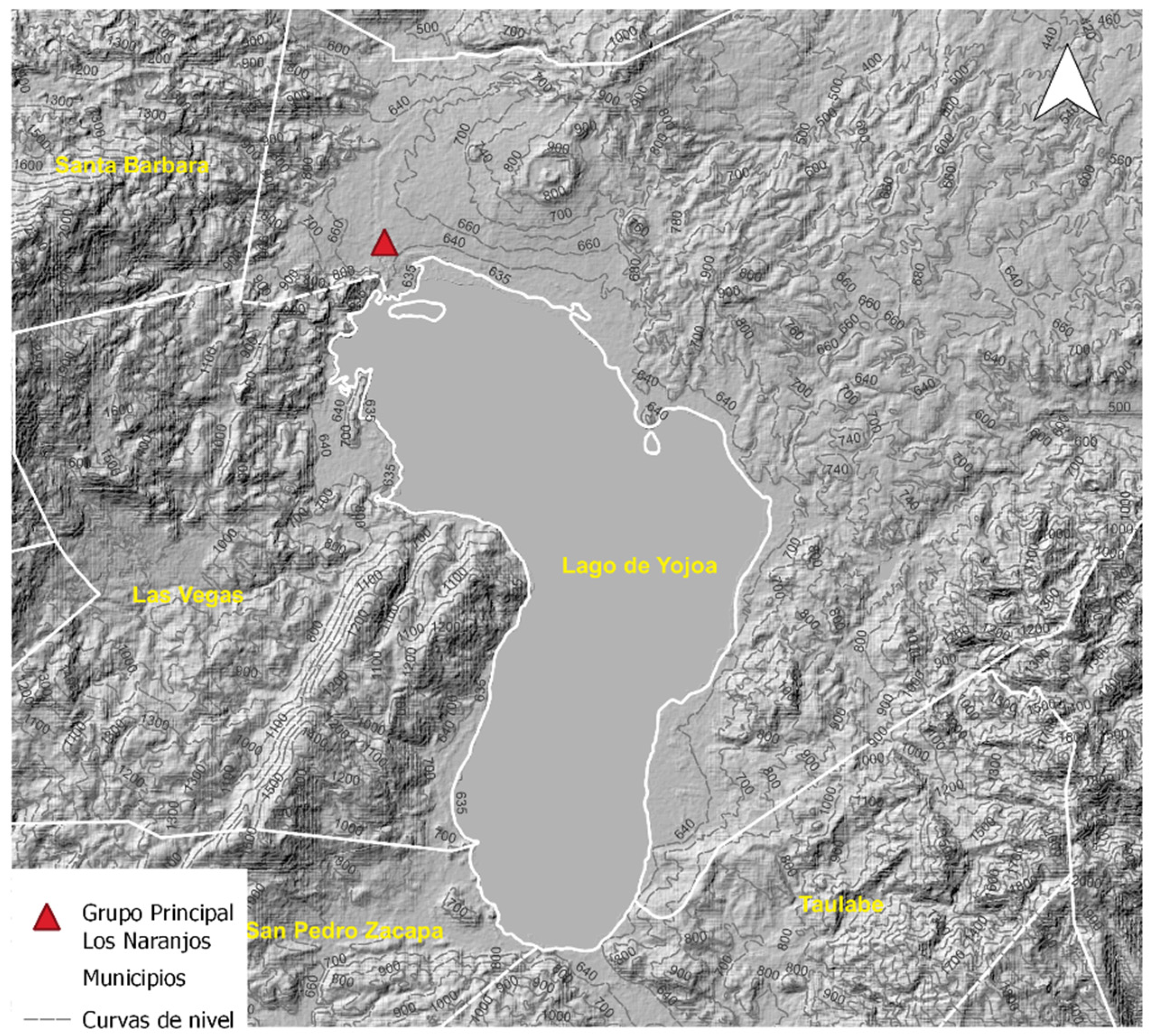
Los Naranjos is part of a basin with rivers and a lake called Yojoa. This body of water has an extension of 96 km2. It is surrounded by two large mountains, Santa Barbara and Cerro Azul Meambar (Figure 1). It is a region of biological diversity, both flora and fauna.
This archaeological site was inhabited since the Mesoamerican Formative period, around 800 B.C. The history of the site is divided into different stages: Jaral (800–400 AC), Eden (400 AC–550 AD), Yojoa (550–950 AD), and Río Blanco (950–1250 AD).
Given its location, it was a densely populated area with a lot of exchange activity. Controlling trade routes, even goods from other areas of Mesoamerica and cultural areas of pre-Columbian America. Los Naranjos was not the only site around the lake. At least eight other sites in the area are mentioned in the literature. However, Los Naranjos is the largest pre-Hispanic center in the basin.
Near the Lake, the Main Group is located. To the north and west of the Main Group, there are others eight groups of structures. The Main Group and residential groups (1 and 8) were occupied until the Yojoa phase in the Late Classic. The structures near the Santa Bárbara Mountain (west of the Main Group) belong to the Río Blanco phase in the Early Postclassic [7]. It gives us an idea of spatial evolution of the site, but it could imply changes in the materials and construction systems used in the different stages. This information is necessary for the purposes of three-dimensional reconstruction.
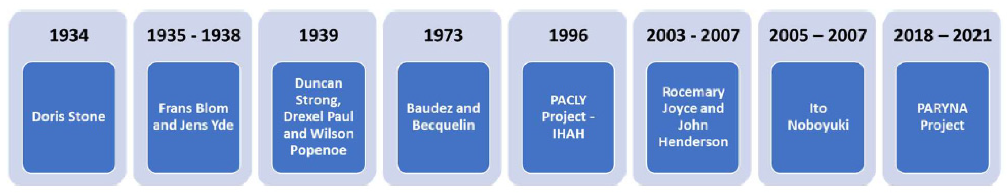
Doris Stone worked at Los Naranjos in the early 1930s. She was the first to describe the site (Figure 2). But, the first map was produced by the French researchers Claude Baudez and Pierre Becquelin between 1967 and 1969 [8]. Maps and other data generated in previous investigations have been compiled. From the investigations, the evolution and growth of this city are identified.
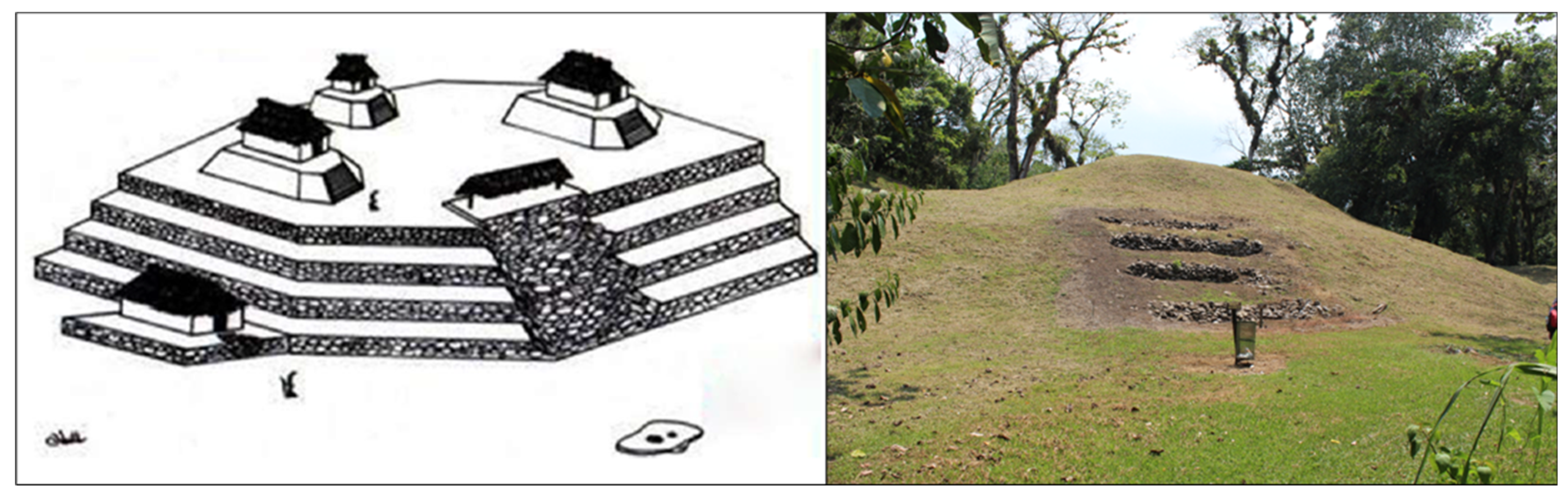
Previous investigations at Los Naranjos archaeological site have generated finds in the Principal Group. Recent investigations focused on other groups of structures in the surroundings of the Principal Group, mainly in Groups 4, 5, and 6. These investigations have produced maps of the Main Group and the other groups of structures in increasingly greater detail. Regarding three-dimensional models, Neil and Valles proposed a model for Structure IV of the Main Group (Figure 3). Apart from this, at least, there are two artistic drawings of the site and its surroundings, oriented towards interpretive activities for the site.
3. Conclusions
The information sources about the site shows that planimetric information exists. Lidar flights could provide more information on the shape and arrangement of the structures for three-dimensional reconstruction of the site. The evolution analyisis of the site and its landscape needs a multiscale and multitemporal approach.
Another point to consider would be the interaction of Los Naranjos structures (Main Group and residential sectors) with respect to the nearby body of water (Lake) to understand its relationship with the organization of the site and the construction of the structures. Since a canal construction that connects the Lake with a dam, the variation in its level has been less. However, the water level may have been higher in the past.
Funding
This research received no external funding.
Institutional Review Board Statement
Not applicable.
Informed Consent Statement
Not applicable.
Data Availability Statement
No new data were created in this study.
Conflicts of Interest
The author declares no conflict of interest.
References
- Iwaniszewsi, S.; Vigliani, S. El paisaje como relación. In Identidad, Paisaje y Patrimonio; Instituto Nacional de Antropología e Historia: Mexico City, México, 2011; pp. 23–38. [Google Scholar]
- Nogué, J. El retorno al paisaje. Enrahonar 2010, 45, 123–136. [Google Scholar] [CrossRef]
- Vigliani, S. Paisaje como seguridad ontológica. In Identidad, Paisaje y Patrimonio; Iwaniszewsi, S., Vigliani, S., Eds.; Instituto Nacional de Antropología e Historia: Mexico City, México, 2011; pp. 39–56. [Google Scholar]
- Criado-Boado, F. Arqueología del paisaje: Las formas del espacio en la Galicia Antigua. INCIPIT 2013. Available online: http://hdl.handle.net/10261/66142 (accessed on 1 December 2023).
- Pescarin, S. Reconstructing Ancient Landscape; Archaeolingua: Budapest, Hungary, 2009. [Google Scholar]
- Forte, M.; Kay, S. Remote sensing, GIS and virtual reconstruction of archaeological landscapes. Bar Int. Ser. 2003, 1151, 109–116. [Google Scholar]
- Sion, J.; Ricardo, R.; Arguijo, J. Proyecto Arqueológico Regional Yojoa Los Naranjos Informe Anual N°1, Temporada de Campo 2018; Instituto Hondureño de Antropología e Historia (IHAH): Tegucigalpa, Honduras, 2019.
- Sion, J.; Arguijo, J.; Perla-Barrera, D.; Rodas, R.; Velásquez, A. Reorganización socio-política entre lago y montañas: El sitio de Los Naranjos y la Cuenca de Yojoa durante el Postclásico Temprano. In Proceedings of the 86th Annual Meeting of the Society for American Archaeology, online, 15–17 April 2021. [Google Scholar]
- Neil, O.; Valles Pérez, E. Excavaciones en la Estructura IV del conjunto principal, Los Naranjos. Yaxkin 2004, XXI, 45–62. [Google Scholar]
Figure 1.
Topographic map of Los Naranjos and surroundings.

Figure 2.
Investigations sequence in Los Naranjos.

Figure 3.
Main Group structure (IV) and model [9].
Figure 3.
Main Group structure (IV) and model [9].

Disclaimer/Publisher’s Note: The statements, opinions and data contained in all publications are solely those of the individual author(s) and contributor(s) and not of MDPI and/or the editor(s). MDPI and/or the editor(s) disclaim responsibility for any injury to people or property resulting from any ideas, methods, instructions or products referred to in the content. |
© 2024 by the author. Licensee MDPI, Basel, Switzerland. This article is an open access article distributed under the terms and conditions of the Creative Commons Attribution (CC BY) license (https://creativecommons.org/licenses/by/4.0/).
Share and Cite
MDPI and ACS Style
Rivera Gutiérrez, N.L. Towards Modeling of the Landscape Evolution of Los Naranjos Archaeological Site, Honduras. Environ. Sci. Proc. 2023, 28, 32. https://doi.org/10.3390/environsciproc2023028032
AMA Style
Rivera Gutiérrez NL. Towards Modeling of the Landscape Evolution of Los Naranjos Archaeological Site, Honduras. Environmental Sciences Proceedings. 2023; 28(1):32. https://doi.org/10.3390/environsciproc2023028032
Chicago/Turabian StyleRivera Gutiérrez, Nohemy Lizeth. 2023. "Towards Modeling of the Landscape Evolution of Los Naranjos Archaeological Site, Honduras" Environmental Sciences Proceedings 28, no. 1: 32. https://doi.org/10.3390/environsciproc2023028032