
Coastal Quarries as Relative Sea-Level Markers: A Methodological Approach Applied in the Apulia Region (Southern Italy)

 , and
, and
Abstract
:1. Introduction
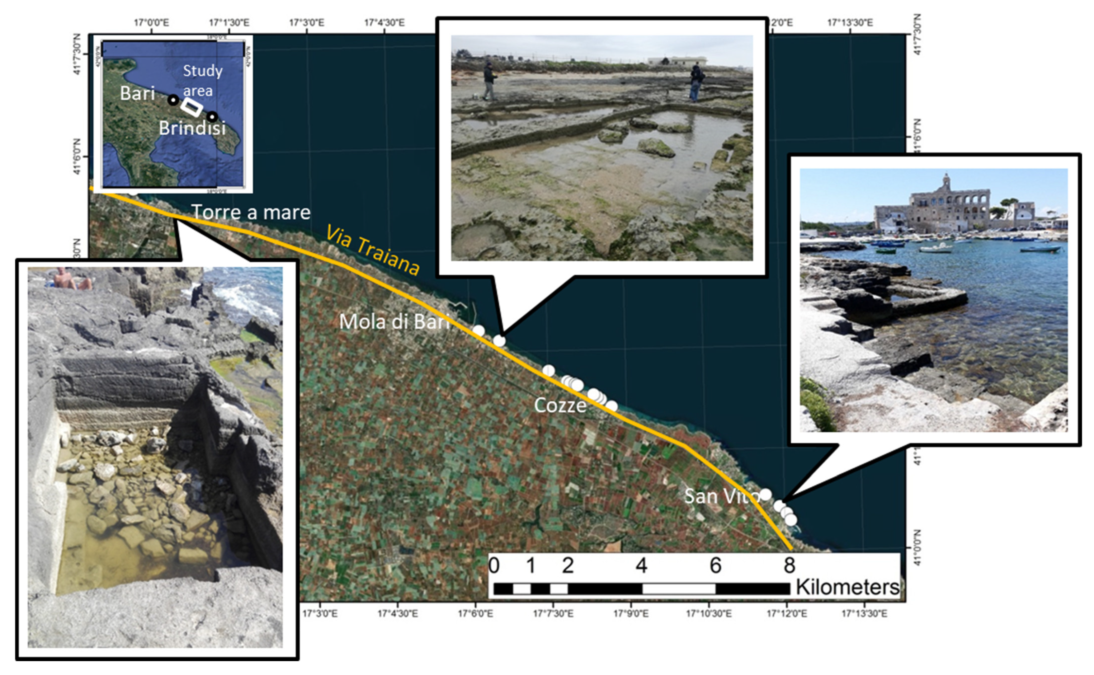
2. Study Area
Tectonic Setting
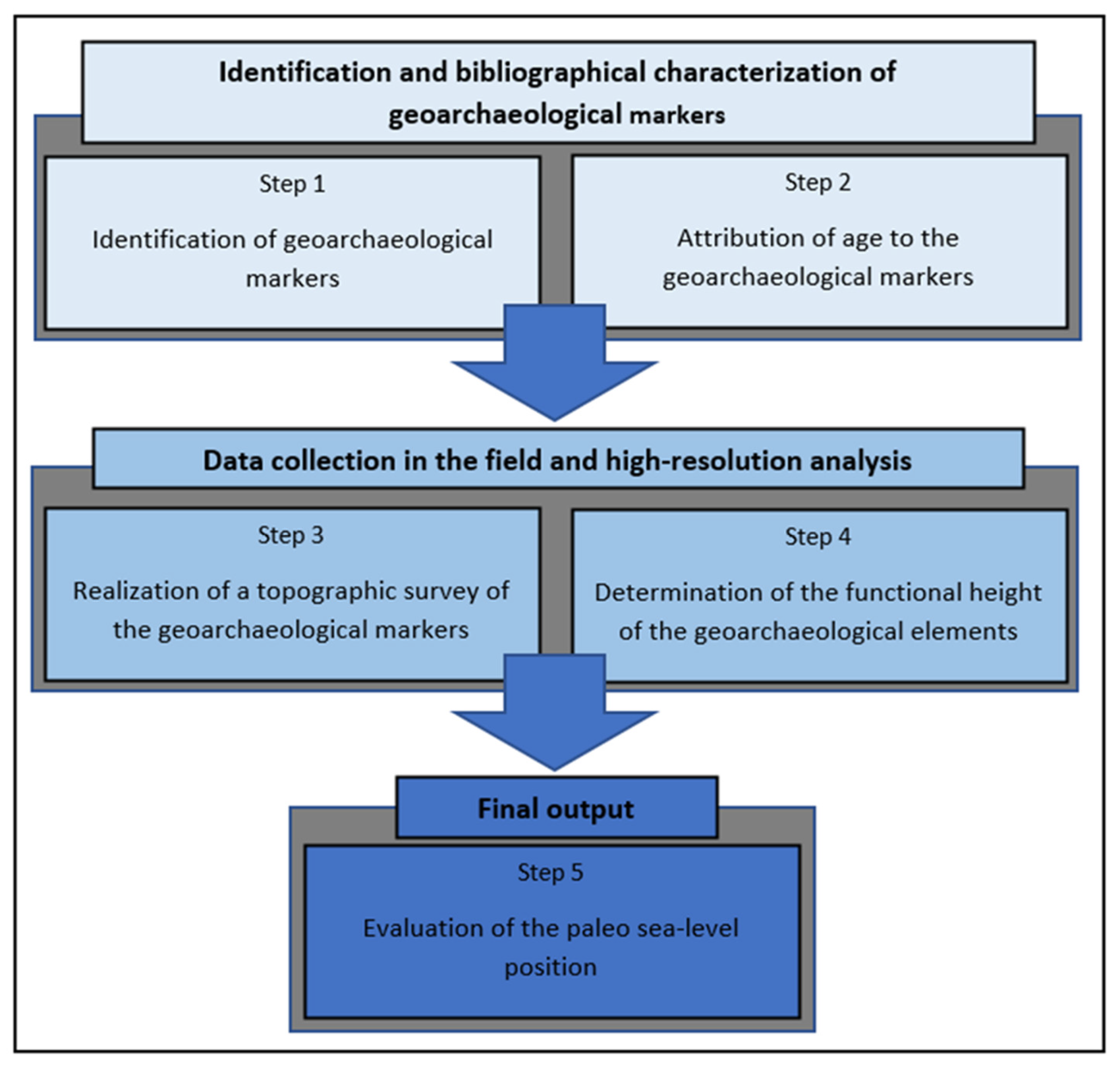
3. Materials and Methods
- Step 1: Identification of geoarchaeological markers and of the related architectural elements that determined their functionality at the time they were built
- Step 2: Attribution of the age to the geoarchaeological markers with relative error estimation
- Step 3: Realization of a topographic survey of the geoarchaeological markers
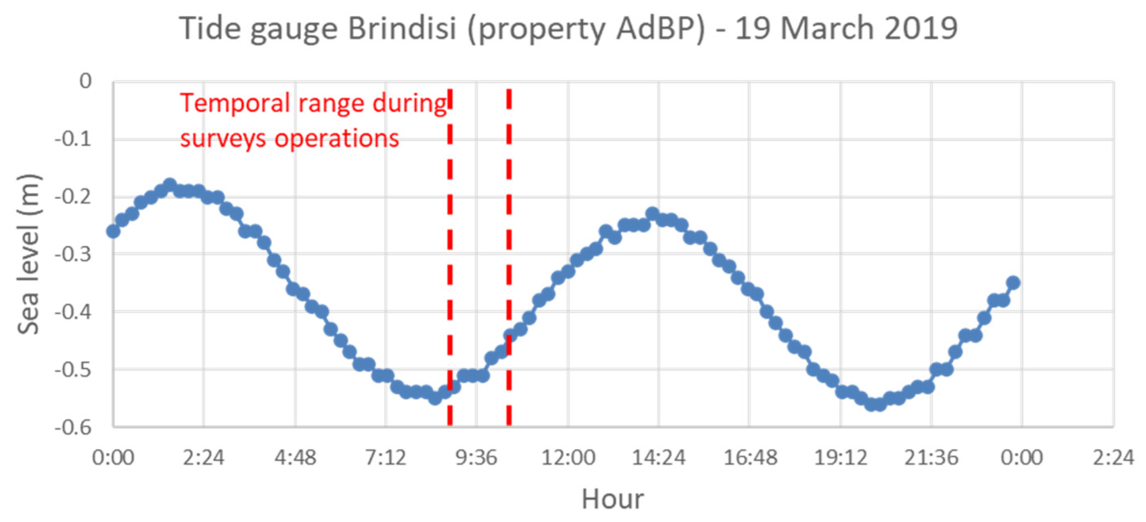
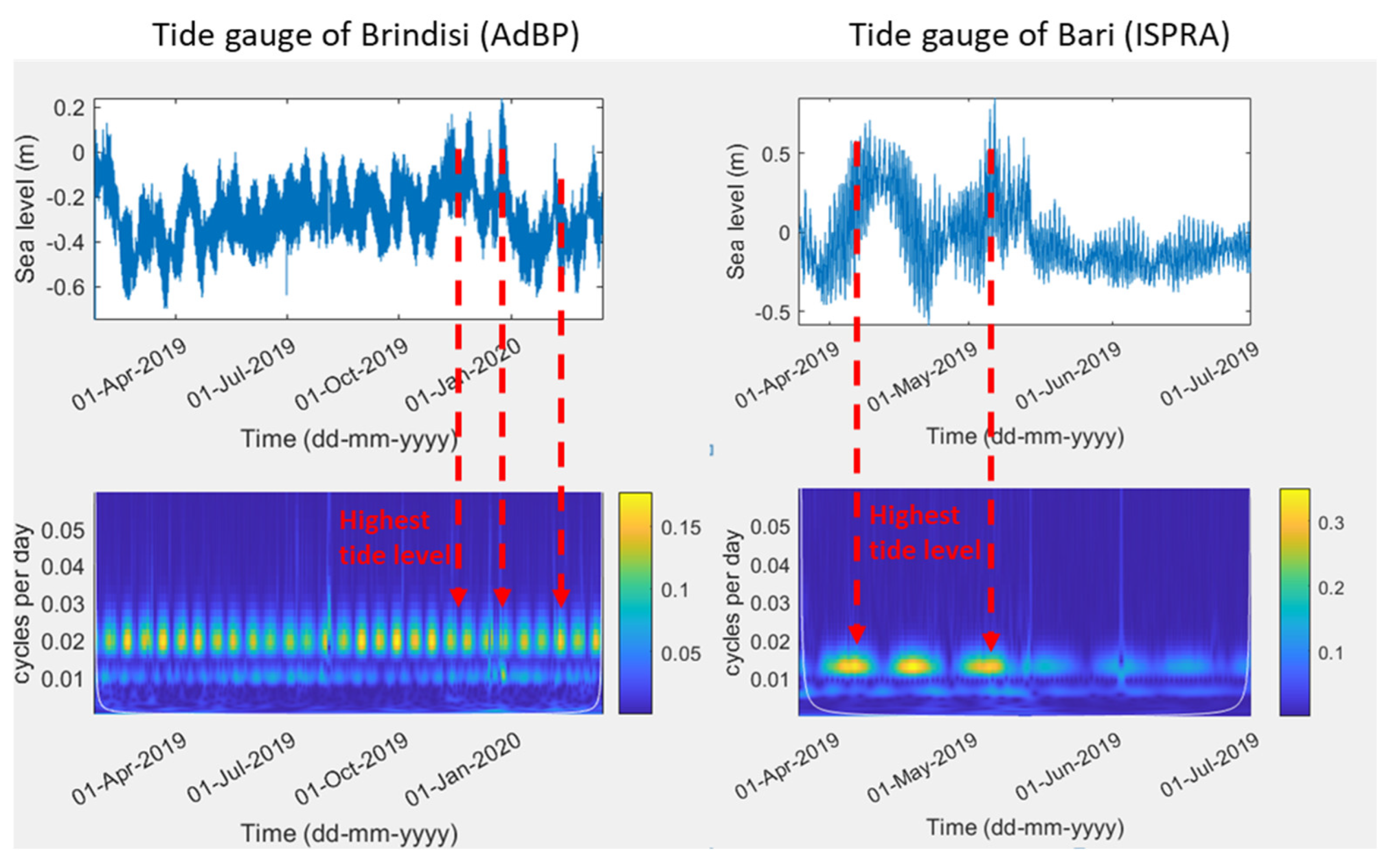
- Step 4: Determination of the functional height of the geoarchaeological elements with respect to the tidal conditions at the time of the survey
- Step 5: Evaluation of the paleo sea-level position
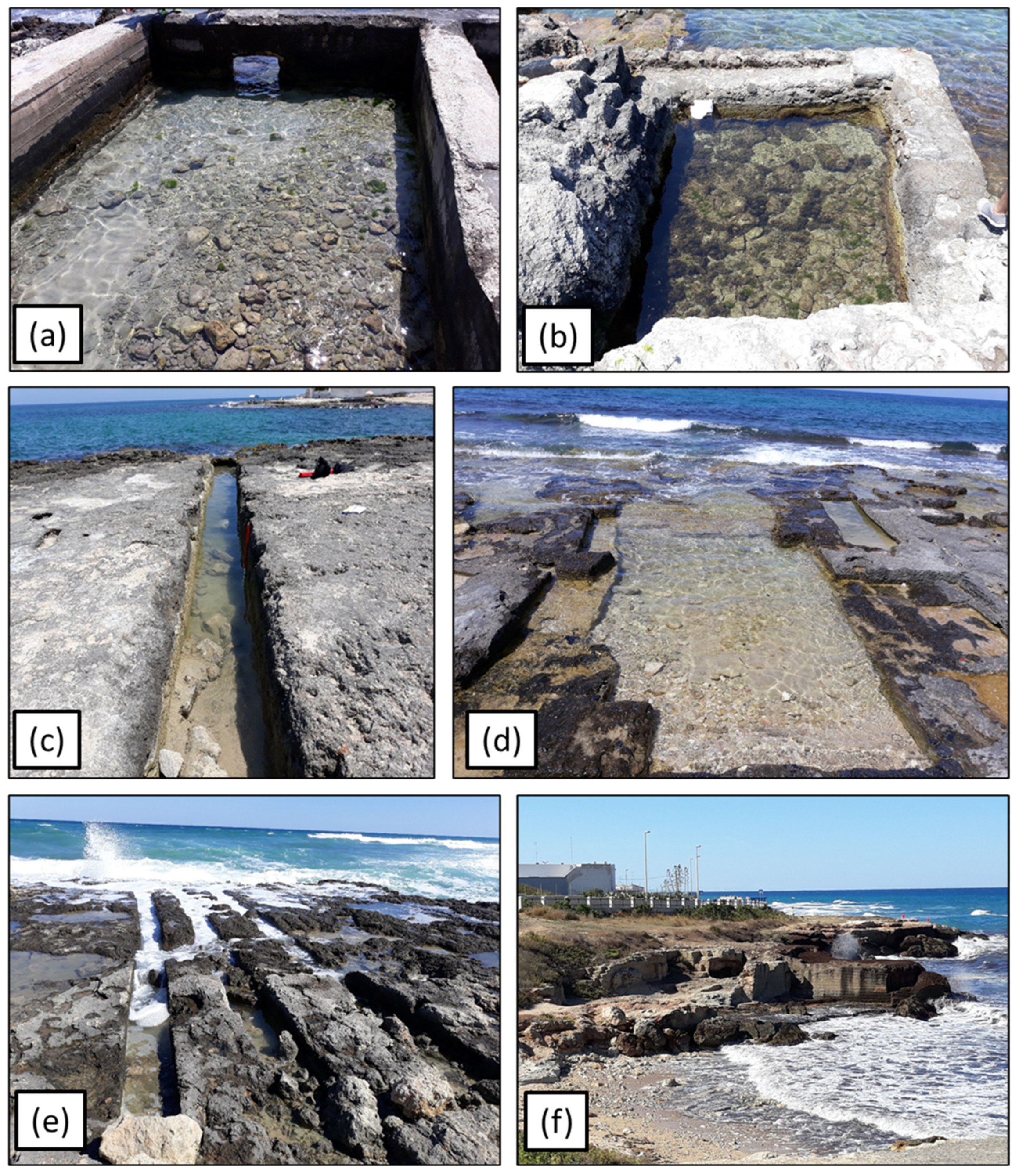
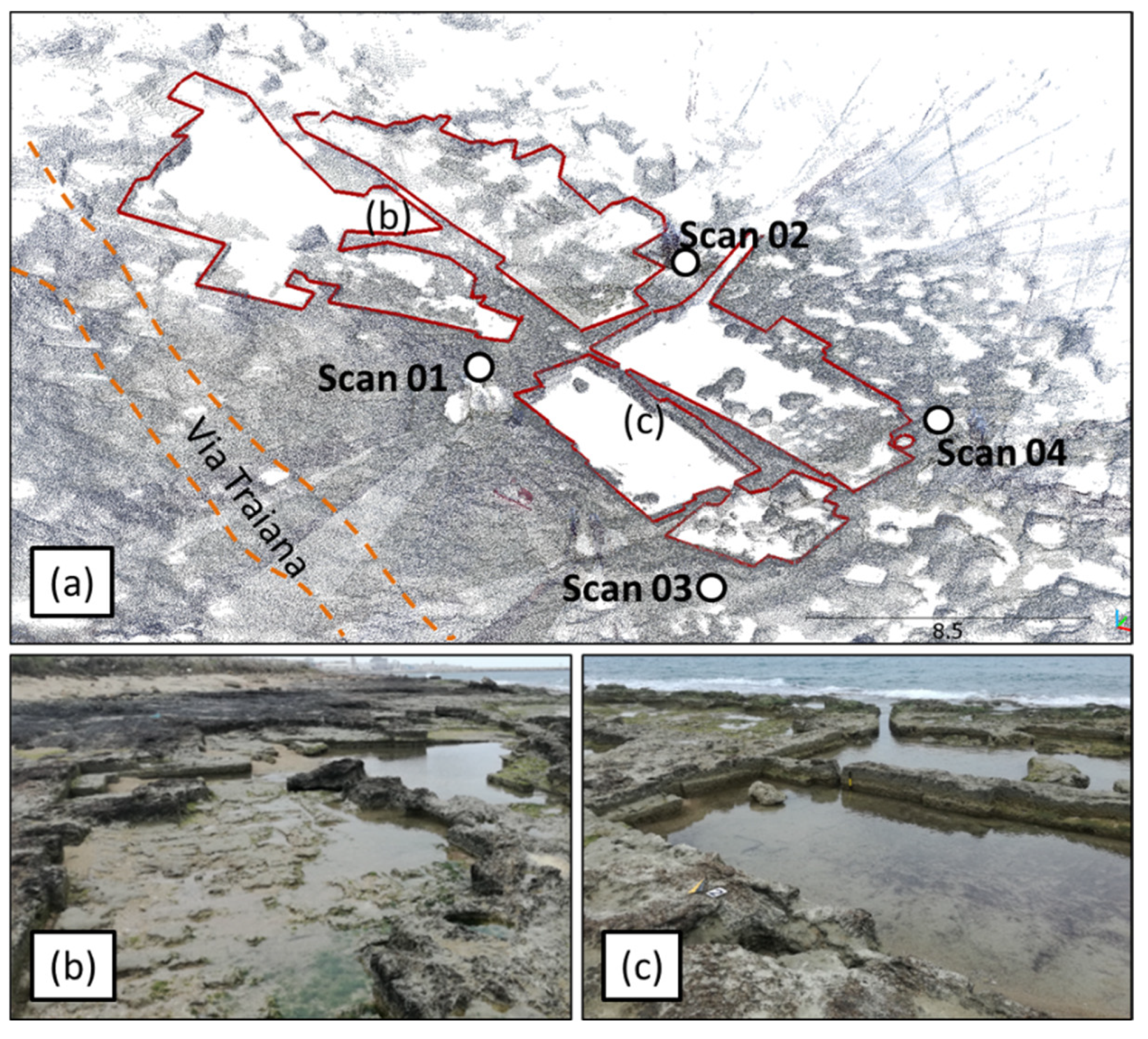
4. Results
- Identification of geoarchaeological markers and of the related architectural elements that determined their functionality at the time they were built
- 2.
- Attribution of the age to the geoarchaeological markers with relative error estimation
- 3.
- Realization of a topographic survey of the geoarchaeological markers
- 4.
- Determination of the functional height of the geoarchaeological markers with respect to tide phases and VLM
- 5.
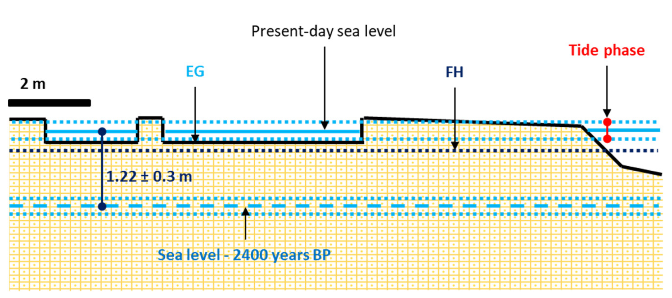
- Evaluation of the paleo sea-level position
- EG is equal to 0.58 ± 0.2 m and represents the elevation of the detachment surface;
- FH is equal to 0.30 ± 0.1 m a.s.l.;
- VLM is equal to 0.02 ± 0.01 m;
- the local tide range is 0.36 ± 0.1 m;
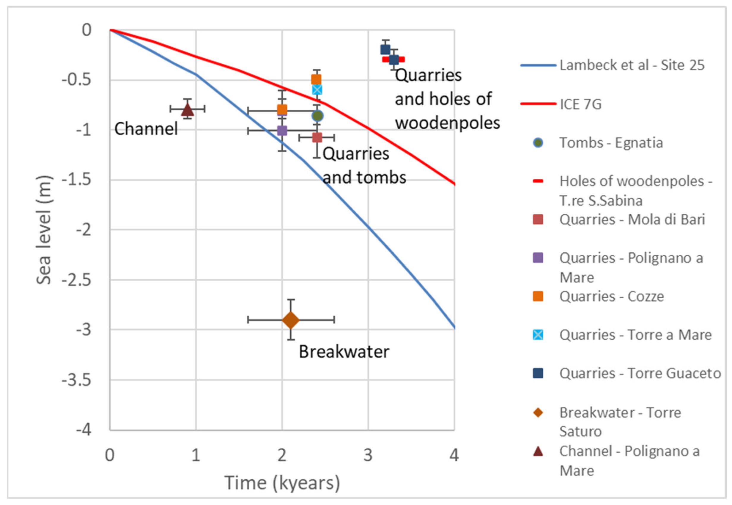
5. Discussion
6. Conclusions
Author Contributions
Funding
Data Availability Statement
Acknowledgments
Conflicts of Interest
References
- Lambeck, K.; Anzidei, M.; Antonioli, F.; Benini, A.; Esposito, A. Sea level in Roman time in the Central Mediterranean and implications for recent change. Earth Planet. Sci. Lett. 2004, 224, 563–575. [Google Scholar] [CrossRef]
- Lambeck, K.; Antonioli, F.; Anzidei, M.; Ferranti, L.; Leoni, G.; Scicchitano, G.; Silenzi, S. Sea level change along the Italian coast during the Holocene and projections for the future. Quat. Int. 2011, 232, 250–257. [Google Scholar] [CrossRef]
- Peltier, W. Global glacial isostasy and the surface of the ice-age Earth: The ICE-5G (VM2) Model and GRACE. Annu. Rev. Earth Planet. Sci. 2004, 32, 111–149. [Google Scholar] [CrossRef]
- Anzidei, M.; Lambeck, K.; Antonioli, F.; Furlani, S.; Mastronuzzi, G.; Serpelloni, E.; Vannucci, G. Coastal structure, sea-level changes and vertical motion of the land in the Mediterranean. Geol. Soc. Lond. Spec. Publ. 2014, 388, 453–479. [Google Scholar] [CrossRef]
- Roy, K.; Peltier, W.R. Relative sea level in the Western Mediterranean Basin: A regional test of the ICE-7G_NA (VM7) model and a constraint on late holocene antarctic deglaciation. Quat. Sci. Rev. 2018, 183, 76–87. [Google Scholar] [CrossRef]
- Scicchitano, G.; Antonioli, F.; Berlinghieri, E.F.C.; Dutton, A.; Monaco, C. Submerged archaeological sites along the ionian coast of Southeastern Sicily (Italy) and implications for the holocene relative sea-level change. Quat. Res. 2008, 70, 26–39. [Google Scholar] [CrossRef]
- Scicchitano, G.; Berlinghieri, E.F.C.; Antonioli, F.; Spampinato, C.R.; Monaco, C. Sacred landscapes and changing sea levels: New interdisciplinary data from the early neolithic to the present in South-Eastern Sicily. In Under the Sea: Archaeology and Palaeolandscapes of the Continental Shelf; Bailey, G.N., Harff, J., Sakellariou, D., Eds.; Coastal Research Library; Springer International Publishing: Cham, Switzerland, 2016; pp. 233–253. ISBN 978-3-319-53160-1. [Google Scholar]
- Anzidei, M.; Antonioli, F.; Benini, A.; Lambeck, K.; Sivan, D.; Serpelloni, E.; Stocchi, P. Sea level change and vertical land movements since the last two millennia along the coasts of Southwestern Turkey and Israel. Quat. Int. 2011, 232, 13–20. [Google Scholar] [CrossRef] [Green Version]
- Lo Presti, V.; Antonioli, F.; Auriemma, R.; Ronchitelli, A.; Scicchitano, G.; Spampinato, C.R.; Anzidei, M.; Agizza, S.; Benini, A.; Ferranti, L.; et al. millstone coastal quarries of the Mediterranean: A new class of sea level indicator. Quat. Int. 2014, 332, 126–142. [Google Scholar] [CrossRef]
- Orrù, P.E.; Mastronuzzi, G.; Deiana, G.; Pignatelli, C.; Piscitelli, A.; Solinas, E.; Spanu, P.G.; Zucca, R. Sea level changes and geoarchaeology between the Bay of Capo Malfatano and Piscinnì Bay (SW Sardinia) in the last 4 kys. Quat. Int. 2014, 336, 180–189. [Google Scholar] [CrossRef]
- Mastronuzzi, G.; Antonioli, F.; Anzidei, M.; Auriemma, R.; Alfonso, C.; Scarano, T. Evidence of relative sea level rise along the coasts of Central Apulia (Italy) during the late holocene via maritime archaeological indicators. Quat. Int. 2017, 439, 65–78. [Google Scholar] [CrossRef]
- Mattei, G.; Rizzo, A.; Anfuso, G.; Aucelli, P.P.C.; Gracia, F.J. A tool for evaluating the archaeological heritage vulnerability to coastal processes: The case study of Naples Gulf (Southern Italy). Ocean Coast. Manag. 2019, 179, 104876. [Google Scholar] [CrossRef]
- Brancaccio, L.; Cinque, A.; Romano, P.; Rosskopf, C.; Russo, F.; Santangelo, N. L’evoluzione delle pianure costiere della Campania: Geomorfologia e Neotettonica. Mem. Soc. Geogr. Ital. 1995, 53, 313–336. [Google Scholar]
- Clark, P.U.; Dyke, A.S.; Shakun, J.D.; Carlson, A.E.; Clark, J.; Wohlfarth, B.; Mitrovica, J.X.; Hostetler, S.W.; McCabe, A.M. The last glacial maximum. Science 2009, 325, 710–714. [Google Scholar] [CrossRef] [PubMed] [Green Version]
- Hughes, P.D.; Gibbard, P.L.; Ehlers, J. Timing of glaciation during the last glacial cycle: Evaluating the concept of a global ‘last glacial maximum’ (LGM). Earth-Sci. Rev. 2013, 125, 171–198. [Google Scholar] [CrossRef]
- Lambeck, K.; Purcell, A. Sea-level change in the Mediterranean sea since the LGM: Model predictions for tectonically stable areas. Quat. Sci. Rev. 2005, 24, 1969–1988. [Google Scholar] [CrossRef]
- Vacchi, M.; Marriner, N.; Morhange, C.; Spada, G.; Fontana, A.; Rovere, A. Multiproxy assessment of holocene relative sea-level changes in the Western Mediterranean: Sea-level variability and improvements in the definition of the isostatic signal. Earth-Sci. Rev. 2016, 155, 172–197. [Google Scholar] [CrossRef] [Green Version]
- Lodolo, E.; Galassi, G.; Spada, G.; Zecchin, M.; Civile, D.; Bressoux, M. Post-LGM coastline evolution of the NW sicilian channel: Comparing high-resolution geophysical data with glacial isostatic adjustment modeling. PLoS ONE 2020, 15, e0228087. [Google Scholar] [CrossRef]
- Mastronuzzi, G.; Sansò, P. Holocene coastal dune development and environmental changes in Apulia (Southern Italy). Sediment. Geol. 2002, 150, 139–152. [Google Scholar] [CrossRef]
- Scardino, G.; Sabatier, F.; Scicchitano, G.; Piscitelli, A.; Milella, M.; Vecchio, A.; Anzidei, M.; Mastronuzzi, G. Sea-level rise and shoreline changes along an open Sandy coast: Case study of Gulf of Taranto, Italy. Water 2020, 12, 1414. [Google Scholar] [CrossRef]
- Rovere, A.; Stocchi, P.; Vacchi, M. Eustatic and relative sea level changes. Curr Clim. Chang. Rep. 2016, 2, 221–231. [Google Scholar] [CrossRef] [Green Version]
- Lambeck, K.; Woodroffe, C.; Antonioli, F.; Anzidei, M.; Gehrels, W.; Laborel, J.; Wright, A. Paleoenvironmental records, geophysical modeling, and reconstruction of sea-level trends and variability on centennial and longer timescales. Fac. Sci.-Pap. Arch. 2010, c04, 61–121. [Google Scholar]
- Aucelli, P.P.C.; Di Paola, G.; Incontri, P.; Rizzo, A.; Vilardo, G.; Benassai, G.; Buonocore, B.; Pappone, G. Coastal inundation risk assessment due to subsidence and sea level rise in a Mediterranean alluvial plain (volturno coastal plain—Southern Italy). Estuar. Coast. Shelf Sci. 2017, 198, 597–609. [Google Scholar] [CrossRef]
- Aucelli, P.P.C.; Mattei, G.; Caporizzo, C.; Cinque, A.; Amato, L.; Stefanile, M.; Pappone, G. Multi-proxy analysis of relative sea-level and paleoshoreline changes during the last 2300 years in the Campi Flegrei Caldera, Southern Italy. Quat. Int. 2021, 602, 110–130. [Google Scholar] [CrossRef]
- Mastronuzzi, G.; Antonioli, F.; Anzidei, M.; Aucelli, P.P.C.; Caporizzo, C.; Donadio, C.; Lo Presti, V.; Mattei, G.; Scardino, G.; Scicchitano, G.; et al. Dove Il mare incontra la terra. In Il Mediterraneo e la sua storia. Catalogo Mostra Thalassa Museo Archeologico Nazionale di Napoli 2020, 1, 22–31. [Google Scholar]
- Vacchi, M.; Ermolli, E.R.; Morhange, C.; Ruello, M.R.; Donato, V.D.; Vito, M.A.D.; Giampaola, D.; Carsana, V.; Liuzza, V.; Cinque, A.; et al. Millennial variability of rates of sea-level rise in the ancient harbour of Naples (Italy, Western Mediterranean sea). Quat. Res. 2020, 93, 284–298. [Google Scholar] [CrossRef]
- Shennan, I.; Horton, B. Holocene land- and sea-level changes in great britain. J. Quat. Sci. 2002, 17, 511–526. [Google Scholar] [CrossRef]
- Engelhart, S.E.; Horton, B.P.; Douglas, B.C.; Peltier, W.R.; Törnqvist, T.E. Spatial variability of late holocene and 20th century sea-level rise along the Atlantic coast of the United States. Geology 2009, 37, 1115–1118. [Google Scholar] [CrossRef] [Green Version]
- Lorscheid, T.; Stocchi, P.; Casella, E.; Gómez-Pujol, L.; Vacchi, M.; Mann, T.; Rovere, A. Paleo sea-level changes and relative sea-level indicators: Precise measurements, indicative meaning and glacial isostatic adjustment perspectives from Mallorca (Western Mediterranean). Palaeogeogr. Palaeoclimatol. Palaeoecol. 2017, 473, 94–107. [Google Scholar] [CrossRef]
- Aucelli, P.P.C.; Mattei, G.; Caporizzo, C.; Cinque, A.; Troisi, S.; Peluso, F.; Stefanile, M.; Pappone, G. Ancient coastal changes due to ground movements and human interventions in the Roman Portus Julius (Pozzuoli Gulf, Italy): Results from photogrammetric and direct surveys. Water 2020, 12, 658. [Google Scholar] [CrossRef] [Green Version]
- Auriemma, R.; Solinas, E. Archaeological remains as sea level change markers: A review. Quat. Int. 2009, 206, 134–146. [Google Scholar] [CrossRef]
- Amato, V.; Aucelli, P.P.C.; Mattei, G.; Pennetta, M.; Rizzo, A.; Rosskopf, C.M.; Schiattarella, M. A geodatabase of Late Pleistocene—Holocene Palaeo sea-level markers in the Gulf of Naples. Alp. Mediterr. Quat. 2018, 31, 5–10. [Google Scholar]
- Morhange, C.; Laborel, J.; Hesnard, A. Changes of relative sea level during the past 5000 years in the ancient harbor of Marseilles, Southern France. Palaeogeogr. Palaeoclimatol. Palaeoecol. 2001, 166, 319–329. [Google Scholar] [CrossRef]
- Brückner, H.; Müllenhoff, M.; Gehrels, R.; Herda, A.; Knipping, M.; Vött, A. From archipelago to floodplain—Geographical and ecological changes in miletus and its environs during the past six millennia (Western Anatolia, Turkey). Z. Fur Geomorphol. Suppl. 2006, 142, 63–83. [Google Scholar]
- Morhange, C.; Marriner, N.; Pirazzoli, P. Evidence of Late Holocene Tsunami events in Lebanon. Z. Für Geomorphol. 2006, 146, 81–95. [Google Scholar]
- Aucelli, P.; Caporizzo, C.; Cinque, A.; Mattei, G.; Pappone, G.; Stefanile, M. New insight on the 1st century bc paleo-sea level and related vertical ground movements along the Baia—Miseno coastal sector (Campi Flegrei, Southern Italy). In Proceedings of the IMEKO TC4 International Conference on Metrology for Archaeology and Cultural Heritage; MetroArchaeo, Florence, Italy, 4–6 December 2019; Volume 2019, pp. 474–477. [Google Scholar]
- Mattei, G.; Troisi, S.; Aucelli, P.P.C.; Pappone, G.; Peluso, F.; Stefanile, M. Sensing the submerged landscape of nisida roman harbour in the gulf of naples from integrated measurements on a USV. Water 2018, 10, 1686. [Google Scholar] [CrossRef] [Green Version]
- Vecchio, A.; Anzidei, M.; Serpelloni, E.; Florindo, F. Natural Variability and Vertical Land Motion Contributions in the Mediterranean Sea-Level Records over the Last Two Centuries and Projections for 2100. Water 2019, 11, 1480. [Google Scholar] [CrossRef] [Green Version]
- Price, S.; Higham, T.; Nixon, L.; Moody, J. Relative sea-level changes in crete: Reassessment of radiocarbon dates from Sphakia and west crete1. Annu. Br. Sch. Athens 2002, 97, 171–200. [Google Scholar] [CrossRef] [Green Version]
- Scheffers, A.; Scheffers, S. Tsunami deposits on the coastline of west crete (Greece). Earth Planet. Sci. Lett. 2007, 259, 613–624. [Google Scholar] [CrossRef]
- Stiros, S.C. The 8.5+ magnitude, AD365 earthquake in crete: Coastal uplift, topography changes, archaeological and historical signature. Quat. Int. 2010, 216, 54–63. [Google Scholar] [CrossRef]
- Evelpidou, N.; Karkani, A. Archaeology and sea-level change. In Encyclopedia of Coastal Science; Finkl, C.W., Makowski, C., Eds.; Springer International Publishing: Cham, Switzerland, 2018; pp. 1–7. ISBN 978-3-319-48657-4. [Google Scholar]
- Morhange, C.; Marriner, N. Archeological and biological relative sea-level indicators. In Handbook of Sea-Level Research; John Wiley & Sons, Ltd.: New York, NY, USA, 2015; pp. 146–156. ISBN 978-1-118-45254-7. [Google Scholar]
- Scarano, T. Refuge or Dwelling Place? The MBA Fortification Wall of Roca (Lecce, Italy): The Spatial and Functional Analysis of Postern C. Rivista di Scienze Preistoriche 2011, LXI-2011, 95–122. [Google Scholar]
- Alfonso, C.; Auriemma, R.; Scarano, T.; Mastronuzzi, G.; Calcagnile, L.; Quarta, G.; Bartolo, M.D. Ancient coastal landscape of the marine protected area of Porto Cesareo (Lecce, Italy): Recent research. Underw. Technol. 2012, 30, 207–215. [Google Scholar] [CrossRef]
- Milella, M.; Pignatelli, C.; Donnaloia, M.; Mastronuzzi, G. Sea level during 4th–2nd century B.P. in Egnazia (Italy) from archaeological and hydrogeological data. Alp. Mediterr. Quat. 2006, 19, 253–260. [Google Scholar]
- Gioia, D.; Bavusi, M.; Di Leo, P.; Giammatteo, T.; Schiattarella, M. Geoarchaeology and geomorphology of the Metaponto area, Ionian coastal belt, Italy. J. Maps 2019, 16, 117–125. [Google Scholar] [CrossRef] [Green Version]
- Antonioli, F.; Anzidei, M.; Lambeck, K.; Auriemma, R.; Gaddi, D.; Furlani, S.; Orrù, P.E.; Solinas, E.; Gaspari, A.; Karinja, S.; et al. Sea-level change during the Holocene from Sardinia and in the northeastern Adriatic (central Mediterranean Sea) from archaeological and geomorphological data. Quat. Sci. Rev. 2007, 26, 2463–2486. [Google Scholar] [CrossRef]
- Ferranti, L.; Antonioli, F.; Mauz, B.; Amorosi, A.; Dai Pra, G.; Mastronuzzi, G.; Monaco, C.; Orrù, P.; Pappalardo, M.; Radtke, U.; et al. Markers of the last interglacial sea-level high stand along the coast of Italy: Tectonic implications. Quat. Int. 2006, 145–146, 30–54. [Google Scholar] [CrossRef]
- Ferranti, L.; Antonioli, F.; Anzidei, M.; Monaco, C.; Stocchi, P. The timescale and spatial extent of vertical tectonic motions in italy: Insights from relative sea-level changes studies. J. Virtual Explor. 2010, 36, 1–35. [Google Scholar] [CrossRef]
- Mastronuzzi, G.; Milella, M.; Piscitelli, A.; Simone, O.; Quarta, G.; Scarano, T.; Calcagnile, L.; Spada, I. Landscape analysis in torre guaceto area (BRindisi) aimed at the reconstruction of the Late Holocene sea level curve. Geogr. Fis. E Din. Quat. 2018, 41, 65–79. [Google Scholar] [CrossRef]
- De Giosa, F.; Scardino, G.; Vacchi, M.; Piscitelli, A.; Milella, M.; Ciccolella, A.; Mastronuzzi, G. Geomorphological signature of late pleistocene sea level oscillations in Torre Guaceto Marine Protected area (Adriatic Sea, SE Italy). Water 2019, 11, 2409. [Google Scholar] [CrossRef] [Green Version]
- Alessio, G.; De Lucia, M.; Gaudiosi, G.; Nappi, R.; Porfido, S. Towards New Insights into Seismic Hazard of the Salento Peninsula (Apulia, Southern Italy) from the Analysis of Far and near Field Seismicity. GNGTS 2016, 2016, 107–111. [Google Scholar]
- Mastronuzzi, G.; Pignatelli, C.; Sansò, P.; Selleri, G. Boulder accumulations produced by the 20th of February, 1743 Tsunami along the coast of southeastern Salento (Apulia region, Italy). Mar. Geol. 2007, 242, 191–205. [Google Scholar] [CrossRef]
- Pierri, P.; Lorenzo, S.D.; Calcagnile, G. Analysis of the low-energy seismic activity in the southern Apulia (Italy). Open J. Earthq. Res. 2013, 2, 91–105. [Google Scholar] [CrossRef] [Green Version]
- Rovida, A.; Locati, M.; Camassi, R.; Lolli, B.; Gasperini, P. The Italian earthquake catalogue CPTI15. Bull. Earthq. Eng. 2020, 18, 2953–2984. [Google Scholar] [CrossRef]
- Galli, P.; Naso, G. The taranta effect of the 1743 earthquake in Salento (Apulia, Southern Italy). Boll. Geofis. Teor. Appl. 2008, 49, 177–204. [Google Scholar]
- Nappi, R.; Gaudiosi, G.; Alessio, G.; De Lucia, M.; Porfido, S. The environmental effects of the 1743 Salento earthquake (Apulia, southern Italy): A contribution to seismic hazard assessment of the Salento Peninsula. Nat. Hazards 2017, 86, 295–324. [Google Scholar] [CrossRef] [Green Version]
- Auriemma, R.; Mastronuzzi, G.; Sansò, P. Relative sea-level changes during the Holocene along the coast of southern Apulia (Italy). Geomorphologie 2004, 1, 19–34. [Google Scholar] [CrossRef]
- Mastronuzzi, G.; Sansò, P. Large boulder accumulations by extreme waves along the adriatic coast of southern Apulia (Italy). Quat. Int. 2004, 120, 173–184. [Google Scholar] [CrossRef]
- Cagnazzo, C.; Potente, E.; Regnauld, H.; Rosato, S.; Mastronuzzi, G. Autumnal beach litter identification by mean of using ground-based IR thermography. Environments 2021, 8, 37. [Google Scholar] [CrossRef]
- Bonaldo, D.; Antonioli, F.; Archetti, R.; Bezzi, A.; Correggiari, A.; Davolio, S.; De Falco, G.; Fantini, M.; Fontolan, G.; Furlani, S.; et al. Integrating multidisciplinary instruments for assessing coastal vulnerability to erosion and sea level rise: Lessons and challenges from the Adriatic sea, Italy. J. Coast. Conserv. 2019, 23, 19–37. [Google Scholar] [CrossRef]
- Bonaldo, D.; Bucchignani, E.; Pomaro, A.; Ricchi, A.; Sclavo, M.; Carniel, S. Wind waves in the Adriatic sea under a severe climate change scenario and implications for the coasts. Int. J. Climatol. 2020, 40, 5389–5406. [Google Scholar] [CrossRef]
- Nandasena, N.A.K.; Scicchitano, G.; Scardino, G.; Milella, M.; Piscitelli, A.; Mastronuzzi, G. Boulder displacements along rocky coasts: A new deterministic and theoretical approach to improve incipient motion formulas. Geomorphology 2022, 407, 108217. [Google Scholar] [CrossRef]
- Tropeano, M.; Sabato, L.; Pieri, P. Filling and cannibalization of a foredeep: The bradanic trough, southern Italy. Geol. Soc. Lond. Spec. Publ. 2002, 191, 55–79. [Google Scholar] [CrossRef]
- De Santis, V.; Scardino, G.; Ortiz, J.E.; Sánchez-Palencia, Y.; Caldara, M. Pleistocene terracing phases in the metropolitan area of Bari—AAR dating and deduced uplift rates of the Apulian Foreland. ROL 2021, 54, 49–61. [Google Scholar] [CrossRef]
- Pieri, P. Geologia della città di bari. Mem. Della Soc. Geol. Ital. 1975, 14, 379–407. [Google Scholar]
- Ricchetti, G.; Ciaranfi, N.; Luperto Sinni, E.; Mongelli, F.; Pieri, P. Geodinamica ed evoluzione sedimentaria e tettonica dell’avampaese apulo. Mem. Della Soc. Geol. Ital. 1992, 41, 57–82. [Google Scholar]
- Andriani, G.F.; Walsh, N. Rocky coast geomorphology and erosional processes: A case study along the Murgia coastline south of Bari, Apulia—SE Italy. Geomorphology 2007, 87, 224–238. [Google Scholar] [CrossRef]
- Waelbroeck, C.; Labeyrie, L.; Michel, E.; Duplessy, J.C.; McManus, J.F.; Lambeck, K.; Balbon, E.; Labracherie, M. Sea-level and deep water temperature changes derived from benthic foraminifera isotopic records. Quat. Sci. Rev. 2002, 21, 295–305. [Google Scholar] [CrossRef]
- Siddall, M.; Rohling, E.J.; Almogi-Labin, A.; Hemleben, C.; Meischner, D.; Schmelzer, I.; Smeed, D.A. Sea-level fluctuations during the last glacial cycle. Nature 2003, 423, 853–858. [Google Scholar] [CrossRef] [PubMed]
- Grant, K.M.; Rohling, E.J.; Ramsey, C.B.; Cheng, H.; Edwards, R.L.; Florindo, F.; Heslop, D.; Marra, F.; Roberts, A.P.; Tamisiea, M.E.; et al. Sea-level variability over five glacial cycles. Nat. Commun. 2014, 5, 5076. [Google Scholar] [CrossRef]
- Doglioni, C.; Mongelli, F.; Pieri, P. The puglia uplift (SE Italy): An anomaly in the foreland of the apenninic subduction due to buckling of a thick continental lithosphere. Tectonics 1994, 13, 1309–1321. [Google Scholar] [CrossRef]
- Doglioni, C.; Tropeano, M.; Mongelli, F.; Pieri, P. Middle-late pleistocene uplift of puglia: An “Anomaly” in the apenninic foreland. Mem. Soc. Geol. Ital. 1996, 51, 101–117. [Google Scholar]
- De Santis, V.; Caldara, M.; Torres, T.; Ortiz, J.E.; Sánchez-Palencia, Y. A review of MIS 7 and MIS 5 terrace deposits along the gulf of Taranto based on new stratigraphic and chronological data. Ital. J. Geosci. 2018, 137, 349–368. [Google Scholar] [CrossRef]
- De Santis, V.; Scardino, G.; Meschis, M.; Ortiz, J.E.; Sánchez-Palencia, Y.; Caldara, M. Refining the middle-late pleistocene chronology of marine terraces and uplift history in a sector of the Apulian foreland (Southern Italy) by applying a synchronous correlation technique and amino acid racemization to Patella Spp. and Thetystrombus Latus. IJG 2021, 140, 438–463. [Google Scholar] [CrossRef]
- Iannone, A.; Pieri, P. Considerazioni critiche sui “Tufi calcarei” delle murge. Nuovi dati litostratigrafici e paleoambientali. Geogr. Fis. E Din. Quat. 1979, 2, 173–186. [Google Scholar]
- Azzaroli, A.; Perno, U.; Radina, B. Note illustrative della carta geologica d’italia alla scala 1:100.000, foglio 188 gravina di puglia. Serv. Geol. 1968, 57, 1–22. [Google Scholar]
- Meletti, C.; Patacca, E.; Scandone, P. Construction of a seismotectonic model: The case of italy. Pure Appl. Geophys. 2000, 157, 11–35. [Google Scholar] [CrossRef]
- Del Gaudio, V.; Pierri, P.; Calcagnile, G.; Venisti, N. Characteristics of the low energy seismicity of central Apulia (southern Italy) and hazard implications. J. Seismol. 2005, 9, 39–59. [Google Scholar] [CrossRef]
- Del Gaudio, V.; Pierri, P.; Frepoli, A.; Calcagnile, G.; Venisti, N.; Cimini, G.B. A critical revision of the seismicity of northern Apulia (Adriatic microplate—Southern Italy) and implicationsfor the identification of seismogenic structures. Tectonophysics 2007, 436, 9–35. [Google Scholar] [CrossRef]
- Ciaranfi, N.; Pieri, P.; Ricchetti, G. Note alla carta geologica delle murge e del salento (Puglia Centromeridionale). Mem. Della Soc. Geol. Ital. 1988, 41, 449–460. [Google Scholar]
- Di Bucci, D.; Caputo, R.; Mastronuzzi, G.; Fracassi, U.; Selleri, G.; Sansò, P. Quantitative analysis of extensional joints in the southern Adriatic foreland (Italy), and the active tectonics of the Apulia region. J. Geodyn. 2011, 51, 141–155. [Google Scholar] [CrossRef] [Green Version]
- Auriemma, R.; Mastronuzzi, G.; Sansò, P. Middle to Late Holocene relative sea-level changes recorded on the coast of Apulia (Italy)/Variations relatives du niveau marin pendant l’holocène moyen et supérieur le long des côtes méridionales des pouilles (Italie). Géomorphol. Relief Processus Environ. 2004, 10, 19–33. [Google Scholar] [CrossRef]
- Auriemma, R.; Mastronuzzi, G.; Sansò, P.; Zongolo, F. The Harbour of the Mansio Ad speluncas (Brindisi, Italy): A key to sea level changes in the past 3500 years? Adv. Archit. Ser. 2005, 19, 5–14. [Google Scholar]
- De Santis, V.; Caldara, M.; Pennetta, L. The marine and alluvial terraces of tavoliere di puglia plain (southern Italy). J. Maps 2014, 10, 114–125. [Google Scholar] [CrossRef]
- Mastronuzzi, G.; Sansò, P. Coastal towers and historical sea level change along the Salento coast (southern Apulia, Italy). Quat. Int. 2014, 332, 61–72. [Google Scholar] [CrossRef]
- Gabellone, F.; Giannotta, M.T.; Monte, A.; Quarta, G. Tomba delle melagrane in Egnazia (Brindisi–Italy): Integrate historical-scientific analyses. In Proceedings of the 6th International Symposium on the Conservation of Monuments in the Mediterranean Basin, Lisboa, Portugal, 7–10 April 2004. [Google Scholar]
- Primavera, M.; Simone, O.; Fiorentino, G.; Caldara, M. The palaeoenvironmental study of the Alimini Piccolo lake enables a reconstruction of holocene sea-level changes in southeast Italy. Holocene 2011, 21, 553–563. [Google Scholar] [CrossRef]
- Bogusz, J.; Klos, A. Wavelet analysis for investigation of precise gnss solutions’ credibility. Artif. Satell. 2010, 45, 163–173. [Google Scholar] [CrossRef] [Green Version]
- Cohen, M.X. A better way to define and describe morlet wavelets for time-frequency analysis. NeuroImage 2019, 199, 81–86. [Google Scholar] [CrossRef] [PubMed]
- Spampinato, C.R.; Costa, B.; Di Stefano, A.; Monaco, C.; Scicchitano, G. The contribution of tectonics to relative sea-level change during the holocene in coastal south-eastern sicily: New data from Boreholes. Quat. Int. 2011, 232, 214–227. [Google Scholar] [CrossRef]
- Antonioli, F.; Mourtzas, N.; Anzidei, M.; Auriemma, R.; Galili, E.; Kolaiti, E.; Lo Presti, V.; Mastronuzzi, G.; Scicchitano, G.; Spampinato, C.; et al. Millstone quarries along the Mediterranean coast: Chronology, morphological variability and relationships with past sea levels. Quat. Int. 2017, 439, 102–116. [Google Scholar] [CrossRef]
- Lambeck, K.; Anzidei, M.; Antonioli, F.; Benini, A.; Verrubbi, V. Tyrrhenian sea level at 2000 BP: Evidence from roman age fish tanks and their geological calibration. Rend. Fis. Acc. Lincei 2018, 29, 69–80. [Google Scholar] [CrossRef]
- Valenzano, E.; Scardino, G.; Cipriano, G.; Fago, P.; Capolongo, D.; De Giosa, F.; Lisco, S.; Mele, D.; Moretti, M.; Mastronuzzi, G. Holocene morpho-sedimentary evolution of the Mar Piccolo Basin (Taranto, Southern Italy). Geogr. Fis. E Din. Quat. 2018, 41, 119–135. [Google Scholar] [CrossRef]


Publisher’s Note: MDPI stays neutral with regard to jurisdictional claims in published maps and institutional affiliations. |
© 2022 by the authors. Licensee MDPI, Basel, Switzerland. This article is an open access article distributed under the terms and conditions of the Creative Commons Attribution (CC BY) license (https://creativecommons.org/licenses/by/4.0/).
Share and Cite
Scardino, G.; Piscitelli, A.; Locuratolo, G.; Scicchitano, G.; Rizzo, A. Coastal Quarries as Relative Sea-Level Markers: A Methodological Approach Applied in the Apulia Region (Southern Italy). Oceans 2022, 3, 172-188. https://doi.org/10.3390/oceans3020013
Scardino G, Piscitelli A, Locuratolo G, Scicchitano G, Rizzo A. Coastal Quarries as Relative Sea-Level Markers: A Methodological Approach Applied in the Apulia Region (Southern Italy). Oceans. 2022; 3(2):172-188. https://doi.org/10.3390/oceans3020013
Chicago/Turabian StyleScardino, Giovanni, Arcangelo Piscitelli, Giuseppe Locuratolo, Giovanni Scicchitano, and Angela Rizzo. 2022. "Coastal Quarries as Relative Sea-Level Markers: A Methodological Approach Applied in the Apulia Region (Southern Italy)" Oceans 3, no. 2: 172-188. https://doi.org/10.3390/oceans3020013