

The Use of the Smart Technology for Creating an Inclusive Urban Public Space


1
Civil and Geo-Environmental Laboratory (LGCgE), Lille University, 59650 Lille, France
2
Urban Planning Engineering Department, An-Najah National University, Nablus P400, Palestine
*
Author to whom correspondence should be addressed.
Smart Cities 2023, 6(5), 2484-2498; https://doi.org/10.3390/smartcities6050112
Submission received: 24 August 2023
/
Revised: 12 September 2023
/
Accepted: 15 September 2023
/
Published: 20 September 2023
(This article belongs to the Special Issue Inclusive Smart Cities)
Abstract
:This paper strives to enhance the inclusivity of urban public spaces, which play a crucial role in providing essential services for all citizens, including community building, physical and mental well-being, social interaction, civic engagement, citizen participation, and economic vitality. Despite the importance of these spaces, as recognized by the UN’s 2030 sustainability goals, the 2023 UN sustainable development report and scholars have drawn attention to their low availability, particularly for low-income individuals, women, children, and people with disabilities. To improve the inclusivity of public spaces, this paper offers the following contributions. (i) The establishment of a comprehensive framework for assessing public space inclusivity. This framework incorporates eight indicators: spatial distribution, typology, facilities and services, green and humid areas, governance and management, safety, user categories, and user satisfaction. (ii) The utilization of the framework to assess the inclusivity of public spaces in Nablus, a major Palestinian city. This assessment confirms the observations made by the UN and scholars regarding the low inclusivity of public spaces; in particular, a lack of public space, poor spatial distribution, and user dissatisfaction with safety conditions and services. (iii) The introduction of the concept of smart public space, which involves citizens in the governance of this space and leverages smart technology for monitoring, providing real-time information and services to citizens, improving facility efficiency, and creating an eco-friendly environment that preserves resources and biodiversity. By addressing these aspects, this paper enhances inclusivity. It promotes the development of an urban public space that caters to the diverse needs of the community, fostering a sense of belonging and well-being for all.
Keywords:
inclusive; public space; SDGs; smart; citizens’ participation; comprehensive; governance; monitoring1. Introduction
This paper discusses the implementation of UN target 11.7 concerning inclusive urban public space and proposes the smart public space concept to help achieve this goal. The significance of this research is related to the crucial role of public space in community building, inclusivity, democracy, physical and mental health, social interaction, civic engagement, citizens’ participation, and economic vitality [1,2]. In addition, this space has a vital role in improving the urban environment, particularly the air quality and biodiversity [3]. The UN 2030 Agenda for Sustainable Development highlighted through target 11.7 the necessity of providing a safe and inclusive public space for all, particularly for women, children, and people with disabilities [4,5].
Based on data from 1072 cities, the 2023 UN Sustainable Development Goals Report [6] alerts that access to open public spaces remains low globally, particularly in developing countries. This report reveals that over 75% of the participating cities have less than 20% of their area dedicated to public spaces and streets. This ratio is much lower than the UN goal, which targets a 45–50% ratio of public spaces to streets. The situation for public space is more critical because this space accounts for only 3.2% of the urban land in 2020, about four times less than that occupied by streets. Scholars highlighted significant disparities in the accessibility to public space [7]. For example, women, children, and people with disabilities face substantial difficulties accessing public space due to safety concerns and inadequate infrastructure. According to the World Health Organization (WHO), women face a higher risk of experiencing violence in public spaces than men, with an estimated one in three women experiencing physical or sexual violence in their lifetime [8]. Furthermore, women are more likely to be excluded from the public space due to gender norms. Similarly, children and persons with disabilities face challenges accessing and utilizing public spaces due to a lack of appropriate infrastructure and facilities, especially in developing countries [9].
Various approaches have been proposed to improve accessibility to public spaces. Esfandfard et al. [10] proposed the “universal design” approach that facilitates access of all to public spaces, regardless of people’s abilities or disabilities. Kent [11] proposed the “placemaking” concept to involve the community in designing and developing public spaces. Ellery and Ellery [12] used this concept to create a public space that is not only functional but also meaningful and enjoyable for all citizens. Community-led initiatives have also been proposed as a practical approach to creating inclusive public spaces. These initiatives engage community members in designing and implementing public spaces, promoting ownership, and ensuring that the public spaces meet the needs of the diverse groups of the community [13]. These initiatives also foster a sense of community and encourage responsible use of public spaces. Zhou [14] highlighted the role of citizens’ participation in creating an inclusive urban public space.
However, initiatives proposed to improve public spaces are still fragmented and have not yet been allowed to achieve the target of creating an inclusive public space, as stated by the last UN Sustainable Development Goals Reports [15,16]. Considering the crucial role of this space in improving the quality of life for all, there is a pressing need for an innovative concept for an inclusive public space that guarantees accessibility for all and improves services to the community. This paper contributes to this objective by (i) establishing a comprehensive framework for an inclusive public space, which is based on both social and environmental indicators, (ii) the application of this framework for the assessment of a public space in the city of Nablus in Palestine to understand the challenges of this space and the expectations of citizens, and (iii) the elaboration of the smart public space concept to address the challenges of an inclusive public space. This concept is inspired by the smart city concept, which offers several opportunities, particularly citizens’ engagement [17,18,19,20] and the use of digital technologies such as the IoT, crowdsourcing, and artificial intelligence for real-time monitoring of public spaces and assessment of public space services. It also provides tools to improve citizens’ safety and accessibility. This concept integrates recent developments in mobile applications and online platforms that offer valuable information on accessibility features, empowering individuals to navigate urban environments [21,22]. Additionally, immersive technologies like virtual and augmented reality offer innovative ways to simulate and design inclusive spaces [23,24].
Smart governance has also a crucial role in the smart public space concept as confirmed by Glebova and Desbordes [25], who used this concept to improve the accessibility and usability of sports facilities and promote tourism.
As highlighted by Dudek et al. [26], a smart intelligent urban system should go beyond simply incorporating advanced technology; it should also play a central role in promoting social responsibility by nurturing a strong sense of community and shared responsibility.
This research aims to establish a framework for the construction of inclusive public spaces, which have a major role in building a socio- and eco-friendly city. The framework includes a set of social and environmental indicators for the assessment of the inclusivity of public spaces. It is used for evaluating public spaces in a complex urban context in the city of Nablus in Palestine to understand the functioning of this place and the expectations of citizens. Based on this evaluation, the research establishes the concept of smart public spaces that improve the functioning and services of spaces to meet citizens’ expectations.
This paper is structured as follows. First, it presents the research methodology and material and emphasizes the indicators for inclusive public spaces. Then, it discusses applying this concept to assessing the public space in the city of Nablus in Palestine. The assessment includes data collection through site visits and users’ opinions and data analysis to determine the public space’s main challenges and the users’ expectations. Finally, this paper presents smart public spaces and how they could help address public space challenges.
2. Methodology and Materials
2.1. Overview
This research focuses on developing an inclusive public space that enables equal access for citizens, regardless of gender, ethnicity, age, and ability. This research is based on a comprehensive literature review and analysis of collected data. This research starts with an extensive literature review about inclusive public spaces to explore previous works about the inclusivity of public spaces and the indicators used for constructing these spaces and their assessments. The indicators are then used to assess the public space in Nablus, a major city in Palestine. The evaluation includes collecting data about the spatial distribution of the public space and its significant features. It also includes interviews with the users of public spaces about their perception of and expectations of these spaces. Data analysis resulted in identifying the social and environmental challenges of public spaces. Smart public space is proposed to address the challenges of public spaces. This concept ensures citizens’ effective participation in public space governance to make it more inclusive. It also uses the capacity of smart technology to enhance the public space’s safety and provide a set of digital services to users.
The following sections provide an extensive description of the research methodology’s first stages, including establishing indicators for inclusive public spaces and data collection for assessing the public space in Nablus.
2.2. Indicators of Inclusive Public Spaces
An inclusive public space should ensure accessibility to all citizens regardless of their home location, gender, ethnicity, age, and abilities [27,28]. It also should provide adequate facilities and services to citizens. Both public authorities and communities need indicators to establish and assess strategies for inclusive public spaces. These indicators could be classified into the following categories (Table 1): (i) spatial distribution, (ii) typology, (iii) facilities and services, (iv) green and humid areas, (v) governance and management, (vi) safety, (vii) users’ category, and (viii) users’ satisfaction.
The spatial distribution measures the proximity of the public space to citizens regardless of their residence or working location. The typology informs about public spaces, such as plazas, linear markets, community yards, sidewalks, recreation areas and parks, and playgrounds. The facilities and services indicators concern the public space equipment such as public toilets, seat shading, water taps, garbage bins, lights, baby services, parking areas, and catering. The green and humid area indicators indicate the ratio and distribution of green and humid areas in the public space. The management of the public space concerns decision-making, citizens’ participation, and maintenance of resources. The safety indicators concern safety equipment, vandalism, and security measurements. Finally, the category of public space users indicates the classifying of the population using the public space according to their gender, age, and abilities, while the users’ satisfaction informs about their degree of satisfaction with the public space.
2.3. Presentation of the Case Study: Nablus City, Palestine
The set of indicators presented in the previous section was used for the assessment of the public space in the city of Nablus in Palestine. This city constitutes a regional urban center in the northern part of the West Bank [29]. This city is recognized as a vibrant commercial and cultural center, housing An-Najah National University and the Palestinian Stock Exchange. With a population of approximately 200,000 residents [30], it plays a crucial role as an administrative, educational, commercial, and industrial hub in the region. Its historical development reflects the influences of the Ottoman and British mandate periods, visible in the old and modern neighborhoods that emerged around the city [31].
The city of Nablus is experiencing significant population growth and density [29]. According to the Palestinian Central Bureau of Statistics [30], Nablus has an annual population growth rate of 2.5% and an average family size of 4.8. This rapid population increase has resulted in high population density, surpassing other regional cities. The expansion of urban areas has been limited, leading to a notable difference in built-up density, which reaches 733 inhabitants/km2 in some neighborhoods [32].
2.4. Data Collection
Based on discussions with the municipality and the community, 63 spaces were selected for this study. Figure 1 illustrates the location of these spaces in the city.
Ten field surveyors collected data using the open-source Kobo Toolbox App [33]. The use of Kobo Toolbox streamlined the data collection process by facilitating efficient and accurate data entry. This toolbox allowed for the collection of various data types, including images and videos. For a comprehensive understanding of the public spaces’ inclusivity, interviews were conducted with different categories of individuals during both daytime and nighttime. This approach enables capturing the perspectives of diverse citizens, including individuals from different age groups, genders, and people with disabilities.
The collected data concerned the indicators presented in Table 1. Data concerning the first two indicators (spatial distribution and typology) were collected by the survey team and confirmed by the municipality. Data concerning other indicators were collected from the users of the public spaces. Around 630 users participated in this survey. The participants encompassed a diverse cross-section of the community, representative of the broader population’s characteristics. The survey protocol dictated that five individuals be interviewed in each public space: two males, two females, and one individual with a disability or a child. This approach aimed to capture a well-rounded understanding of users’ experiences across different demographics. Notably, the female respondents exhibited greater responsiveness in completing the survey forms, which can be attributed to factors such as the form’s length and the women’s engagement with the subject matter.
3. Results
3.1. Spatial Distribution of Public Spaces
The total area of the public spaces within the city was found to be 496,359 m2, which includes market areas, community yards, and streets, such as linear market streets. The per capita ratio of public spaces is 2.6 m2/inhabitant, which falls below local and international standards that vary between 5 m2 and 9 m2 per person [34,35]. The allocation of public spaces in the master plan is below the standards; at least an additional one km2 of new public space is required to meet the standards.
Figure 2 illustrates the distribution of public spaces in the city. It shows that public spaces are concentrated in the city center and the old city. The eastern part has reduced public spaces, including two camps and a low-income population. The results show that only 30% of the city’s neighborhoods have access to public spaces within a five min walking distance, while over 41% need more than ten minutes of walking to access public spaces. The open spaces better serve the western part than the eastern part. The results also show that 41% of the public spaces’ entrances are unclear, posing difficulty in accessing these spaces.
When explicitly considering parks and playgrounds, a more nuanced perspective emerges regarding walking distances. In this context, merely 7% of these recreational facilities are conveniently accessible within a 5 min walking radius. Conversely, 73% of parks and playgrounds demand traversing distances exceeding ten minutes on foot. This differentiation highlights a more pronounced challenge in accessing recreational spaces designed for leisure and outdoor activities. The disparities between accessibility to public spaces at large and specifically to parks and playgrounds underscore the complex spatial distribution within the city.
Moreover, the survey revealed that most public spaces operate on a neighborhood scale, typically ranging from 500 to 2000 m² in size. Pocket parks spanning fewer than 500 m² are conspicuously limited in number despite their noteworthy impact on urban aesthetics. These small green areas contain a distinctive capacity to increase the aesthetic attractiveness of the urban landscape. Regrettably, their limited presence could curtail small-scale relaxation, leisure, and visual delight opportunities.
3.2. Public Space Typologies
Figure 3 and Figure 4 show the public space typology, including plazas, linear markets, community yards, sidewalks, transportation stations, parking lots, informal playgrounds, recreation areas and parks, playgrounds, and empty spaces. The linear market dominates the public space. Rafidia Street, a famous street in the city, was identified as the most vital public space. Furthermore, the old city has a significant concentration of community yards, which exhibit a semi-public character. However, there was a shortage of plazas, parking, and playgrounds.
3.3. Facilities
Figure 5 shows the facilities of the public spaces. It indicates excellent public lighting (87%), but no significant facilities such as public toilets, assistance for blind people, bike parking, direction signs, and baby care facilities. Only 32% of the public spaces are equipped with seating facilities, 19% have water taps, 28% have artificial shade, 56% have garbage facilities, and 32% have vehicle parking. We also observe that only 41% of the public spaces provide access for people with disabilities.
3.4. Green and Humid Areas
The survey indicates a deficit in green areas. Less than 30% of the public spaces include green areas. Figure 6 illustrates the distribution of green areas in the city. It indicates a high concentration of green area in Jamal Abdul-Nasser Park and the quasi-absence of this area of the old town. The lack of green areas in public spaces negatively impacts these spaces’ attractiveness and environmental function.
3.5. Governance and Management
The public spaces in Nablus are mainly governed and managed by the municipality. Only two of the sixty-three public spaces are owned by UNRWA (United Nations Relief and Works Agency for Palestine Refugees) within the camps and managed jointly with the municipality. Citizens are not formally involved in the governance and management of these spaces.
Regarding formality, 52 designated public spaces and 11 informal spaces have organically evolved in response to community needs. This interplay between formal and informal spatial designations exemplifies the complexity of urban management and the multifaceted nature of public space utilization.
3.6. Safety
Figure 7 shows that during the daytime, 66% of the interviewed women reported feeling safe in public spaces, 32% felt partially safe, and only 2% did not feel safe, while 84% of men reported being safe, 15% somewhat safe, and only 1% unsafe. The situation changes significantly during nighttime. Only 19% of women reported feeling safe, 43% partially safe, and 38% unsafe. In comparison, 66% of men reported feeling safe, 27% partially safe, and 7% unsafe. This result indicates safety presents a strong obstacle for women to access public spaces, in particular during nighttime.
3.7. Category of the Public Space Users
Figure 8 shows that the number of day users of the public spaces is three times the number of night users. Moreover, it shows that young males dominate the use of public spaces, while people with disabilities have reduced use of them during the day and night.
3.8. Users’ Satisfaction
Figure 9 shows the users’ satisfaction with facilities and services in public spaces. Seating facilities garnered 35% satisfaction, with 15% expressing partial satisfaction and 50% reporting dissatisfaction. Lighting received 36% satisfaction, 46% partial satisfaction, and 18% dissatisfaction. For garbage bins, 29% were satisfied, 54% partially satisfied, and 17% dissatisfied. Water taps garnered 36% satisfaction and 64% partial satisfaction. Artificial shading satisfied 47%, partially satisfied 47%, but left 6% unsatisfied. Vehicular parking generated 17% satisfaction, 56% partial satisfaction, and 27% dissatisfaction. Regarding accessibility for disabled individuals, 34% found it satisfying, 17% partially satisfying, and 49% unsatisfying.
These results highlight a high level of user dissatisfaction, particularly with seating facilities, waste disposal, and facilities for individuals with disabilities. In turn, this significantly affects the aesthetic value of the public spaces. Specifically, around 40% of the public spaces are regarded as uncomfortable, while over 60% of the reviewed open public spaces have garbage management issues.
4. Discussion
The analysis conducted in the preceding section reveals a significant shortfall in the quality of public spaces within the city of Nablus, highlighting a clear lack of inclusivity. This assessment has exposed a multitude of shortcomings, including but not limited to inadequate spatial coverage, inequitable distribution, notable absences in key areas of the city, security concerns, particularly affecting women, low levels of civic engagement, and a dearth of essential facilities such as public toilets, access to clean tap water, seating, artificial shade, clear navigation signage, and facilities catering to individuals with disabilities. These collective deficiencies severely restrict citizens’ accessibility to public spaces, underscoring the urgent need for comprehensive improvement measures.
The following sections provide an extensive discussion of a significant issue of inclusive public spaces: their accessibility and smart public spaces as solutions to improve the inclusivity of public spaces.
4.1. Accessibility of Public Spaces
The distribution and accessibility of public spaces emerge as a significant concern, with the total area falling below recommended standards. The spatial concentration of public spaces in certain areas exacerbates the disparities between neighborhoods. This is particularly evident in the city’s east, where reduced public spaces are available for low-income populations and two refugee camps. Consequently, urban planning efforts should prioritize the equitable distribution of public spaces across the city, considering the diverse needs of neighborhoods and population groups [36,37]. Engaging community stakeholders, including residents from marginalized groups, can provide valuable insights and ensure that public spaces reflect the needs and expectations of the entire community [38,39].
Furthermore, urban planning should focus on improving the accessibility and visibility of public spaces through clear entrances and wayfinding signage [40]. This will enhance the overall user experience and encourage more people, including those with disabilities, to utilize the city’s public spaces.
The results also indicate a gender disparity in the use of public spaces, particularly during nighttime. Women reported feeling less safe than men, which was likely influenced by insufficient lighting and social problems occurring in these spaces. Moreover, people with disabilities have a reduced presence in public spaces, reflecting the lack of inclusive design and facilities that address their needs.
Strategies should be implemented to encourage the understanding and diverse participation of different age groups, genders, and abilities in public spaces. This should inform the design and management of public spaces to ensure their inclusivity, particularly safety for all community members [41]. Integrating the voices and perspectives of women, people with disabilities, and other marginalized groups in decision-making will foster a sense of ownership and belonging among users [42].
The physical features of public spaces are generally unsatisfactory, in particular seating, lighting, garbage disposal, green coverage, and facilities for women and people with disabilities. Seating was identified as a critical area for improvement. Moreover, the lack of necessary features for specific user groups, such as women’s needs and accessibility considerations for people with disabilities, highlights a significant gap in the design and construction of these spaces. Enhancing the quality and diversity of physical features, along with ensuring the provision of inclusive amenities, can contribute to creating more attractive and user-friendly public spaces that meet the diverse needs and preferences of the community.
4.2. Smart Public Spaces
Analysis of the data collected regarding the public spaces in Nablus highlights the imperative for proactive measures to enhance their inclusivity and ensure alignment with users’ expectations. More precisely, the analysis showed a high user dissatisfaction with public space safety, facilities, services, and accessibility. It also highlighted a lack of citizen participation in the governance and management of public spaces.
Considering the vital role of public spaces in cities and the Palestinian regulations concerning the crucial role of public spaces [43,44,45,46], a new strategy is required in Palestine for building smart spaces that involve citizens in their government and use the latest technology to improve the quality of services to citizens and the environment.
Smart public spaces should involve citizens in public space governance because they are the main ones concerned with this space. Also, they can provide users with valuable information about the public space location, design, facilities, services, and social environment. These spaces should also be monitored by the latest technology to improve services to users, in particular accessibility, safety, navigation, access to tap water, toilets, seating, shaded areas, and green and humid spaces. They should also provide specific services for people with disabilities. These spaces should also be eco-friendly, use advanced technology for water saving, irrigation, renewable energy, smart public lighting, and biodiversity survey and protection.
Smart public spaces are inspired by the smart city concept [47,48,49], which aims to improve the quality of life in cities by involving citizens in city affairs and improve the efficiency of urban systems and functions.
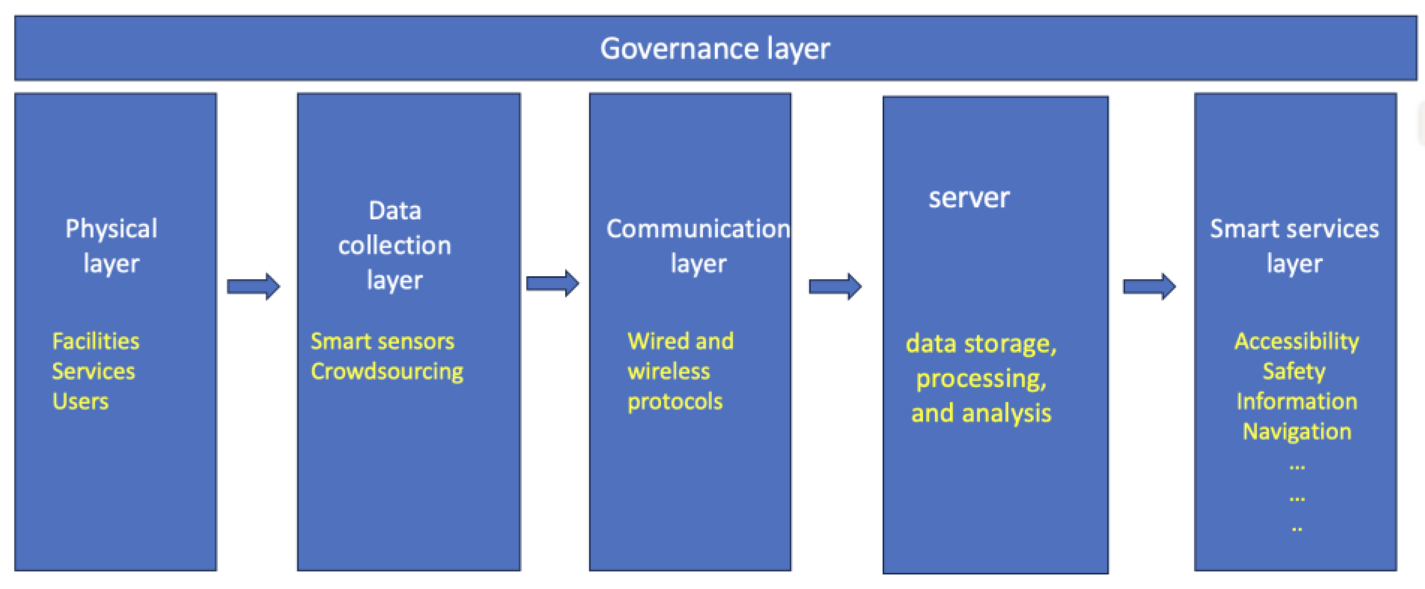
Figure 10 depicts the architecture of the innovative smart public space concept, as outlined by Shahrour and Xie [50]. This architectural framework comprises six layers, each vital in shaping the concept’s functionality and efficacy. These layers encompass governance, physical infrastructure, data collection mechanisms, communication protocols, server infrastructure, and smart services.
The governance layer, positioned horizontally, serves as the linchpin for orchestrating the organizational dynamics and decision-making processes inherent to the design, amenities, services, and overall operation of the public space. Central to its role is ensuring a robust and inclusive engagement of critical stakeholders—from citizens who utilize the space to policymakers who shape its policies and the administrative entities overseeing its execution.
The physical layer constitutes the tangible foundation of the concept, encompassing the spatial elements, equipment installations, facilities, and the diverse services offered within the public space. It also extends its scope to encompass citizens, who not only act as end-users of the space but also serve as a wellspring of valuable data and critical evaluations that contribute to the enhancement of the public space experience.
The data collection layer includes tools and resources meticulously orchestrated to amass comprehensive data about the public space. This layer encompasses an array of Internet of Things (IoT) components, such as intelligent sensors endowed with the capability to meticulously monitor a spectrum of vital parameters within the public space ecosystem. These parameters encompass aspects ranging from spatial occupancy, ambient air quality, and accessibility metrics to the intricate functionality of lighting installations, facilities’ operational status, and overall safety benchmarks. The data layer also includes interactive tools like mobile apps that transmit users’ observations and suggestions. The data collection process must adhere to a stringent commitment to transparency while dutifully respecting the overarching regulations concerning data privacy.
The communication layer connects the physical layer to the server infrastructure. Employing both wired and wireless communication protocols, this layer orchestrates the seamless transmission and exchange of data. Advanced communication mechanisms, such as 5G technology and the innovative LoRaWan protocols, are at the forefront of its capabilities and contribute to the swift and robust transmission of data across the interconnected network. Through these sophisticated communication avenues, the public space concept attains an elevated level of cohesion, ensuring that the insights gleaned from the data-rich physical layer are channeled effectively to and from the central server hub.
The server layer is pivotal in executing multiple functions, including data storage, processing, and analysis. The latter employs various mathematical and information technology tools, including statistics and artificial intelligence, to metamorphose collected data into valuable insights, actions, and services. It can furnish statistical insights regarding public space usage and operational efficacy. These insights, in turn, contribute to enhancing service quality, optimizing equipment efficiency, and rationalizing resource allocation. Additionally, the system excels in real-time anomaly detection, swiftly implementing corrective measures when necessary. Furthermore, its contributions extend to fortifying safety through enhancing lighting systems, utilizing security cameras, and deploying a mobile app alert system.
The smart services layer encompasses a broad spectrum of actions that elevate citizen experiences and environmental conditions. Services include real-time updates on public space dynamics, facility operations, service availability, navigation aids, social connections, Wi-Fi accessibility, efficient irrigation practices, intelligent public lighting, and streamlined parking management.
5. Conclusions
This paper examined the improvement of implementing the UN Target 11.7 concerning inclusive urban public spaces. It contributes to this goal by elaborating the concept of the inclusive public space. The significance of this concept lies in recognizing the crucial role that public spaces play in community building, physical and mental well-being, social interaction, civic engagement, citizen participation, and economic vitality. However, the 2023 UN Sustainable Development Goals Report and scholars have raised concerns about the limited access to public spaces, particularly for low-income individuals, women, children, and people with disabilities.
Considering the significance of inclusive public spaces, this paper proposed a comprehensive framework for assessing this inclusivity. The framework employs eight indicators: spatial distribution, typology, facilities, green areas, governance, safety, user categories, and user satisfaction. These indicators were employed to evaluate the inclusivity of public spaces in Nablus, a major Palestinian city. The assessment validated the observations made by the UN and scholars, highlighting the low inclusivity of public spaces in Nablus, particularly due to inadequate availability and poor spatial distribution. Additionally, the assessment revealed significant citizens’ dissatisfaction with safety conditions and services. It underscores the significance of involving citizens in the governance of public spaces, as they are the primary stakeholders who can provide valuable data and insights to enhance the quality and performance of these spaces.
Enhancing the inclusivity of public spaces necessitates a comprehensive approach that engages citizens in their governance and leverages the latest technology, particularly smart technology. By employing such technology, real-time information and services can be provided to citizens, enabling the monitoring of public spaces, improving facility efficiency, and creating an eco-friendly environment that preserves resources and biodiversity. This paper outlines how smart public spaces contribute to achieving this inclusivity and proposes an architectural framework for its implementation.
This paper suffered from some limitations. The main limitation concerned data collection because authorities were not able to provide basic data about the public space policy strategy, planning, facilities, and functions. Field visits and interviews were then used to collect data. In the future, data could be collected more frequently and involve more people through mobile applications and smart monitoring. The interviews focused on the citizens’ perception of public space facilities, safety, and governance. In the future, interviews should be extended to the use of digital tools to understand citizens’ expectations and fears about these tools, which will help in the development of smart tools for public spaces.
Author Contributions
Conceptualization, M.I. and I.S.; methodology, M.I. and I.S.; software, M.I.; validation, I.S. and I.H.; formal analysis, M.I. and I.H.; writing review and editing, M.I. and I.S.; supervision, I.S. All authors have read and agreed to the published version of the manuscript.
Funding
This research received no external funding.
Data Availability Statement
The data presented in this study are available on request from the corresponding author. The data are not publicly available due to privacy and proprietary concerns.
Conflicts of Interest
The authors declare no conflict of interest.
References
- World Health Organization, Regional Office for Europe. Urban Green Spaces and Health; WHO/EURO:2016-3352-43111-60341; World Health Organization, Regional Office for Europe: Geneva, Switzerland, 2016; Available online: https://apps.who.int/iris/handle/10665/345751 (accessed on 18 August 2023).
- UN. General Assembly Transforming Our World: The 2030 Agenda for Sustainable Development|Department of Economic and Social Affairs. 2015. Available online: https://sdgs.un.org/2030agenda (accessed on 14 March 2023).
- Yang, J.; Zhao, Y.; Zou, Y.; Xia, D.; Lou, S.; Liu, W.; Ji, K. Effects of Tree Species and Layout on the Outdoor Thermal Environment of Squares in Hot-Humid Areas of China. Buildings 2022, 12, 1867. [Google Scholar] [CrossRef]
- UN DESA. Goal 11|Department of Economic and Social Affairs. 2015. Available online: https://sdgs.un.org/goals/goal11 (accessed on 14 March 2023).
- OHCHR. Policy Guidelines for Inclusive Sustainable Development Goals: Sustainable Cities and Communities; OHCHR: Geneva, Switzerland, 2020. [Google Scholar]
- United Nations Department for Economic and Social Affairs. Sustainable Development Goals Report 2023: Special Edition; United Nations: San Francisco, CA, USA, 2023; Available online: https://unstats.un.org/sdgs/report/2023/ (accessed on 18 August 2023).
- Ahmimed, C. Inclusive Cities: Trends and New Initiatives; Department for Economic and Social Affairs (UNDESA) Division for Social Policy and Development: New York, NY, USA, 2018; Available online: https://www.un.org/development/desa/family/wp-content/uploads/sites/23/2018/05/Inclusivecities-DESAEGM16May2018CAHMIMED.pdf (accessed on 20 July 2023).
- WHO. Violence against Women. 2021. Available online: https://www.who.int/news-room/fact-sheets/detail/violence-against-women (accessed on 14 March 2023).
- Wellenstein, A.; García Mora, M.E. Breaking Barriers and Reconstructing a Disability-Inclusive Society. 3 December 2021. Available online: https://blogs.worldbank.org/latinamerica/breaking-barriers-and-reconstructing-disability-inclusive-society (accessed on 20 June 2023).
- Esfandfard, E.; Wahab, M.H.; Amat, R.C. Universal design in urban public spaces for people with disability. Case study of Tehran, Iran. Plan. Malays. 2018, 16. [Google Scholar] [CrossRef]
- Kent, E. Leading urban change with people powered public spaces. The history, and new directions, of the Placemaking movement. J. Public Space 2019, 4, 127–134. [Google Scholar] [CrossRef]
- Ellery, P.J.; Ellery, J. Strengthening Community Sense of Place through Placemaking. Urban Plan. 2019, 4, 237–248. [Google Scholar] [CrossRef]
- Ni, M.; Cattaneo, T. Design for Urban Resilience: A Case of Community-led Placemaking Approach in Shanghai China. In Cross-Cultural Design. Culture and Society; Lecture Notes in Computer Science; Rau, P.-L.P., Ed.; Springer International Publishing: Cham, Switzerland, 2019; pp. 207–222. [Google Scholar]
- Zhou, S. Understanding “Inclusiveness” in Public Space: Learning from Existing Approaches. sustain.ubc.ca. 20 September 2019. Available online: https://sustain.ubc.ca/about/resources/understanding-inclusiveness-public-space-learning-existing-approaches (accessed on 12 June 2023).
- Ahvenniemi, H.; Huovila, A.; Pinto-Seppä, I.; Airaksinen, M. What are the differences between sustainable and smart cities? Cities 2017, 60, 234–245. [Google Scholar] [CrossRef]
- Angelidou, M.; Psaltoglou, A.; Komninos, N.; Kakderi, C.; Tsarchopoulos, P.; Panori, A. Enhancing sustainable urban development through smart city applications. J. Sci. Technol. Policy Manag. 2017, 9, 146–169. [Google Scholar] [CrossRef]
- Granier, B.; Kudo, H. How are citizens involved in smart cities? Analysing citizen participation in Japanese “Smart Communities”. Inf. Polity 2016, 21, 61–76. [Google Scholar] [CrossRef]
- Cardullo, P.; Kitchin, R. Being a ‘citizen’ in the smart city: Up and down the scaffold of smart citizen participation in Dublin, Ireland. GeoJournal 2019, 84, 1–13. [Google Scholar] [CrossRef]
- Prandi, C.; Barricelli, B.R.; Mirri, S.; Fogli, D. Accessible wayfinding and navigation: A systematic mapping study. Univ. Access Inf. Soc. 2023, 22, 185–212. [Google Scholar] [CrossRef]
- Bastos, D.; Fernández-Caballero, A.; Pereira, A.; Rocha, N.P. Smart City Applications to Promote Citizen Participation in City Management and Governance: A Systematic Review. Informatics 2022, 9, 89. [Google Scholar] [CrossRef]
- Chiu, C.-C.; Lee, L.-C. System satisfaction survey for the App to integrate search and augmented reality with geographical information technology. Microsyst. Technol. 2018, 24, 319–341. [Google Scholar] [CrossRef]
- Lau, B.P.L.; Wijerathne, N.; Ng, B.K.K.; Yuen, C. Sensor Fusion for Public Space Utilization Monitoring in a Smart City. IEEE Internet Things J. 2018, 5, 473–481. [Google Scholar] [CrossRef]
- Dick, E. Current and Potential Uses of AR/VR for Equity and Inclusion. Available online: https://itif.org/publications/2021/06/01/current-and-potential-uses-arvr-equity-and-inclusion/ (accessed on 20 July 2023).
- McKenna, H.P. Adaptive Reuse of Cultural Heritage Elements and Fragments in Public Spaces: The Internet of Cultural Things and Applications as Infrastructures for Learning in Smart Cities. In Proceedings of the 2017 13th International Conference on Signal-Image Technology & Internet-Based Systems (SITIS), Jaipur, India, 4–7 December 2017; pp. 479–484. [Google Scholar] [CrossRef]
- Glebova, E.; Desbordes, M. Smart Sports in Smart Cities. In Smart Cities and Tourism: Co-Creating Experiences, Challenges and Opportunities: Co-Creating Experiences, Challenges and Opportunities; Goodfellow Publishers Ltd.: Oxford, UK, 2021; pp. 60–73. Available online: https://books.google.fr/books?hl=en&lr=&id=TaWaEAAAQBAJ&oi=fnd&pg=PA60&dq=Smart+Sports+in+Smart+Cities&ots=MBCL6s3szX&sig=VvVe_j7RmSSDU8MhATW6XJYohMU&redir_esc=y#v=onepage&q=Smart%20Sports%20in%20Smart%20Cities&f=false (accessed on 8 September 2023).
- Dudek, M.; Bashynska, I.; Filyppova, S.; Yermak, S.; Cichoń, D. Methodology for assessment of inclusive social responsibility of the energy industry enterprises. J. Clean. Prod. 2023, 394, 136317. [Google Scholar] [CrossRef]
- Landman, K. Inclusive public space: Rethinking practices of mitigation, adaptation and transformation. Urban Des. Int. 2020, 25, 211–214. [Google Scholar] [CrossRef]
- Pineda, V.S. What is Inclusive and Accessible Public Space? J. Public Space 2022, 7, 5–8. [Google Scholar] [CrossRef]
- The World Bank. Palestinian Cities Get a Boost through Integrated Urban Planning and Innovation; World Bank: Washington, DC, USA, 2021; Available online: https://www.worldbank.org/en/news/feature/2021/10/14/palestinian-cities-get-a-boost-through-integrated-urban-planning-and-innovation (accessed on 24 June 2023).
- Palestinian Central Bureau of Statistics. Preliminary Results of the Population, Housing and Establishments Census 2017. 2018. Available online: https://www.pcbs.gov.ps/Downloads/book2364-1.pdf (accessed on 8 September 2023).
- Ghadban, S.S. Architecture in Palestine. In Encyclopaedia of the History of Science, Technology, and Medicine in Non-Western Cultures; Selin, H., Ed.; Springer: Dordrecht, The Netherlands, 2008; pp. 225–238. [Google Scholar] [CrossRef]
- Hadba, L.; Ashqar, H.I.; Tuqan, N.A.S.; Lourenço, J. Effects of Public Participation in Urban Planning: The Case of Nablus City. 2014. Available online: http://repositorium.sdum.uminho.pt/ (accessed on 24 June 2023).
- KoboToolbox. Available online: https://www.kobotoolbox.org/ (accessed on 23 June 2023).
- Ministry of Municipal Rural Affairs and Housing. المعايير التخطيطية للخدمات العامة والاقليمية المحلية ومستوياتها المختلفة Planning Standards for Local Public and Regional Services and Their Different Levels. 2015. Available online: https://momrah.gov.sa/ar/node/13020 (accessed on 5 August 2023).
- European Commission. How Can Public Space in a City Help to Address Future Urban Challenges? European Commission: Brussels, Belgium, 2019; Available online: https://urban.jrc.ec.europa.eu/thefutureofcities/ (accessed on 5 August 2023).
- UN Habitat. Background Note by UN Habitat-Proposal for a Public Open Space Indicator. 2015. Available online: https://unstats.un.org/unsd/post-2015/activities/egm-on-indicator-framework/docs/Background%20note%20by%20UN%20Habitat-%20Proposal%20for%20a%20public%20open%20space%20indicator-EGM_Feb2015.pdf (accessed on 8 September 2023).
- Wolch, J.R.; Byrne, J.; Newell, J.P. Urban green space, public health, and environmental justice: The challenge of making cities ‘just green enough’. Landsc. Urban Plan. 2014, 125, 234–244. [Google Scholar] [CrossRef]
- Abusaada, H.; Elshater, A. Effect of people on placemaking and affective atmospheres in city streets. Ain Shams Eng. J. 2021, 12, 3389–3403. [Google Scholar] [CrossRef]
- Waddington, H.; Sonnenfeld, A.; Finetti, J.; Gaarder, M.; John, D.; Stevenson, J. Citizen engagement in public services in low- and middle-income countries: A mixed-methods systematic review of participation, inclusion, transparency and accountability (PITA) initiatives. Campbell Syst. Rev. 2019, 15, e1025. [Google Scholar] [CrossRef]
- Project for Public Spaces. What Role Can Design Play in Creating Safer Parks? 31 December 2018. Available online: https://www.pps.org/article/what-role-can-design-play-in-creating-safer-parks (accessed on 5 August 2023).
- Wojnowska-Heciak, M.; Suchocka, M.; Błaszczyk, M.; Muszyńska, M. Urban Parks as Perceived by City Residents with Mobility Difficulties: A Qualitative Study with In-Depth Interviews. Int. J. Environ. Res. Public Health 2022, 19, 2018. [Google Scholar] [CrossRef]
- Polko, P.; Kimic, K. Gender as a factor differentiating the perceptions of safety in urban parks. Ain Shams Eng. J. 2022, 13, 101608. [Google Scholar] [CrossRef]
- MoLG. ل التخطيط التنموي المحلي (Strategic Development & Investment Plan); 3rd ed.; Ramallah, Palestine, 2018. Available online: https://www.mdlf.org.ps/Document/SDIP%20manual%202018(1).pdf (accessed on 8 September 2023).
- MoLG. دليل التخطيط العمراني- دليل إجراءات وأدوات إعداد المخططات الهيكلية في الضفة الغربية وقطاع غزة (Urban Planning Manual—A Guide to Procedures and Tools for Preparing Master Plans in the West Bank and Gaza Strip); Ramallah, Palestine, 2013. Available online: https://procurement-notices.undp.org/view_file.cfm?doc_id=139183 (accessed on 8 September 2023).
- MoLG. دليل تخطيط الطرق والمواصلات في المناطق الحضرية بفلسطين (Guide to Planning Roads and Transportation in Urban Areas in Palestine). 2013. Available online: https://urbanplanninglibrary.blogspot.com/2022/01/ROADS-MANUAL.html (accessed on 24 June 2023).
- Itair, M.; Hijazi, I.; Qanazi, S.; Zaidalkilani, S.; Issa, A. Localizing sustainable development goals in strategic development planning procedures. Case study: Local development planning manual for the Palestinian cities and towns. Najah Univ. J. Res.-B 2022, 37, 1491–1526. [Google Scholar] [CrossRef]
- Szczepańska, A.; Kaźmierczak, R.; Myszkowska, M. Smart City Solutions from a Societal Perspective—A Case Study. Int. J. Environ. Res. Public Health 2023, 20, 5136. [Google Scholar] [CrossRef] [PubMed]
- Gracias, J.S.; Parnell, G.S.; Specking, E.; Pohl, E.A.; Buchanan, R. Smart Cities—A Structured Literature Review. Smart Cities 2023, 6, 1719–1743. [Google Scholar] [CrossRef]
- Albrecht, F.; Moser, J.; Hijazi, I. Assessing façade visibility in 3D city models for city marketing. Int. Arch. Photogramm. Remote Sens. Spat. Inf. Sci. 2013, XL-2/W2, 1–5. [Google Scholar] [CrossRef]
- Shahrour, I.; Xie, X. Role of Internet of Things (IoT) and Crowdsourcing in Smart City Projects. Smart Cities 2021, 4, 1276–1292. [Google Scholar] [CrossRef]
Figure 1.
Localization of the surveyed public spaces in the city of Nablus.

Figure 2.
The scale of open public spaces in the city of nablus.
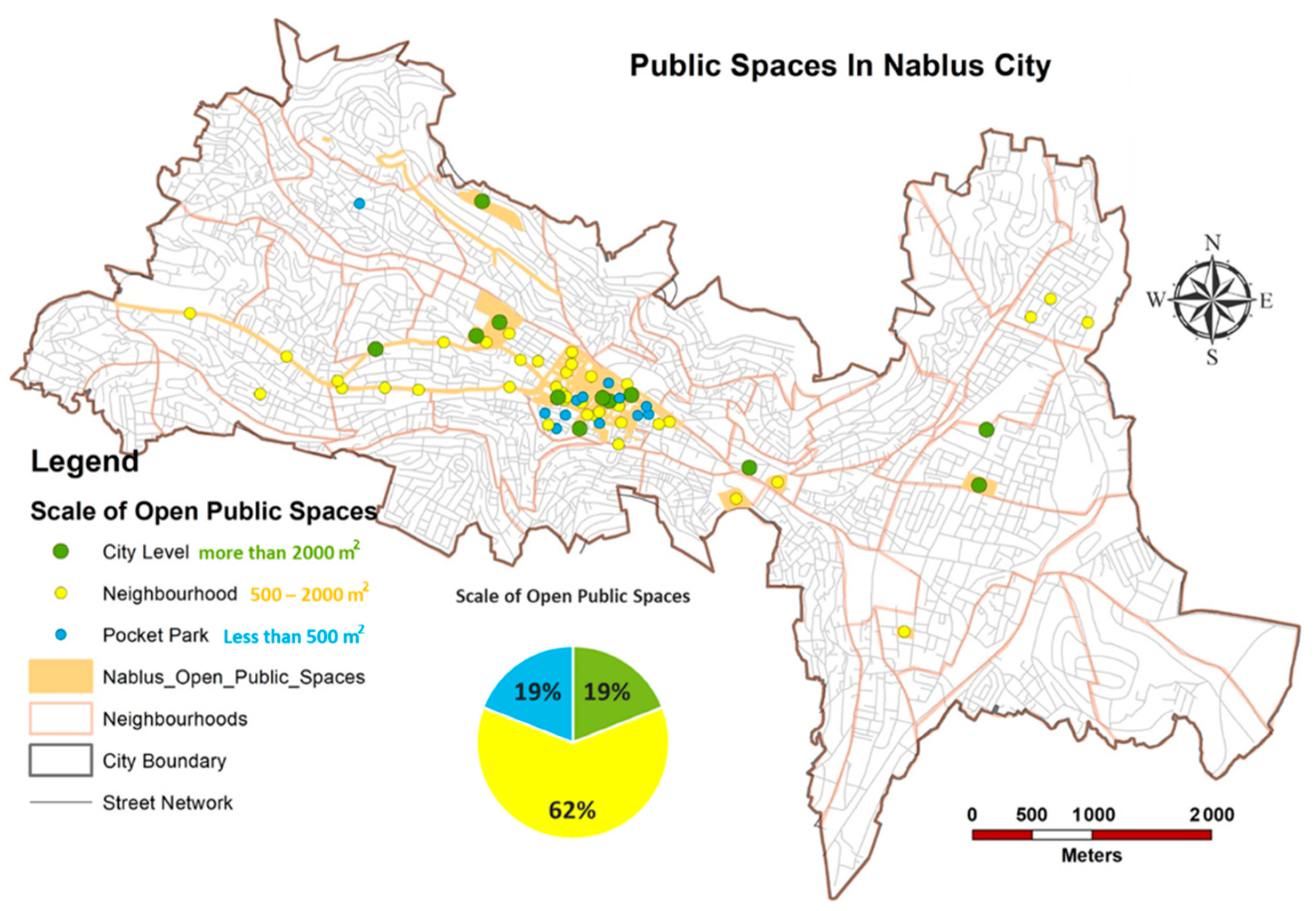
Figure 3.
Spatial distribution of the public spaces according to their typology.
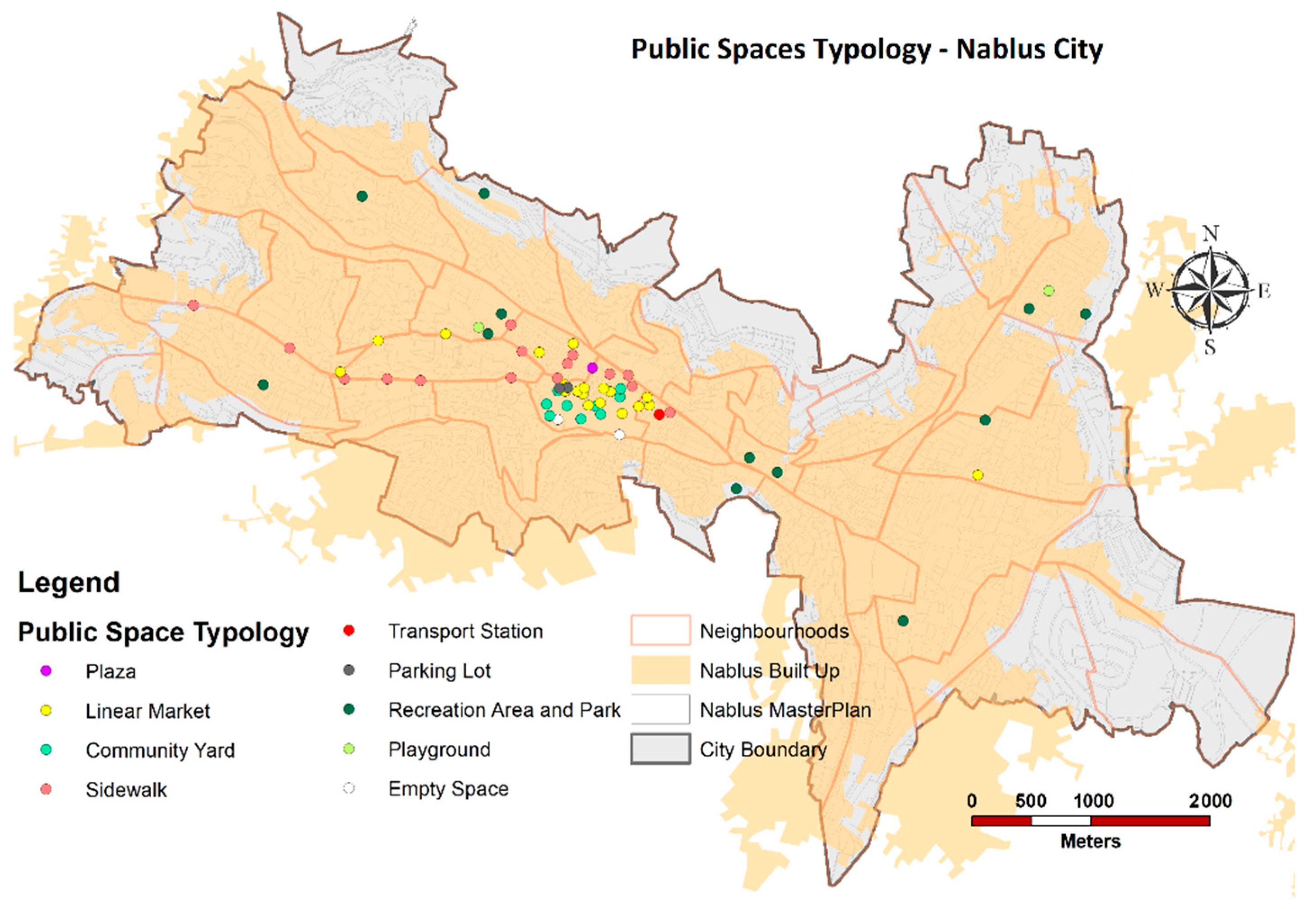
Figure 4.
Repartition of the public spaces’ typology.
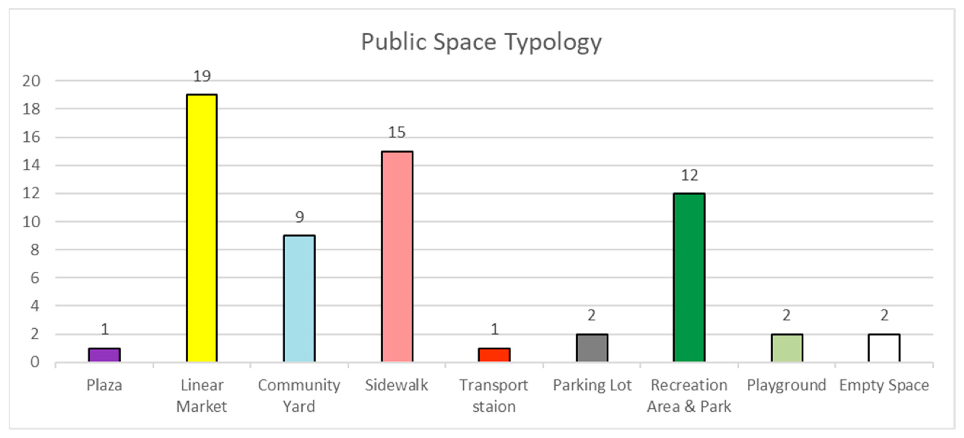
Figure 5.
Facilities of the public spaces in Nablus.
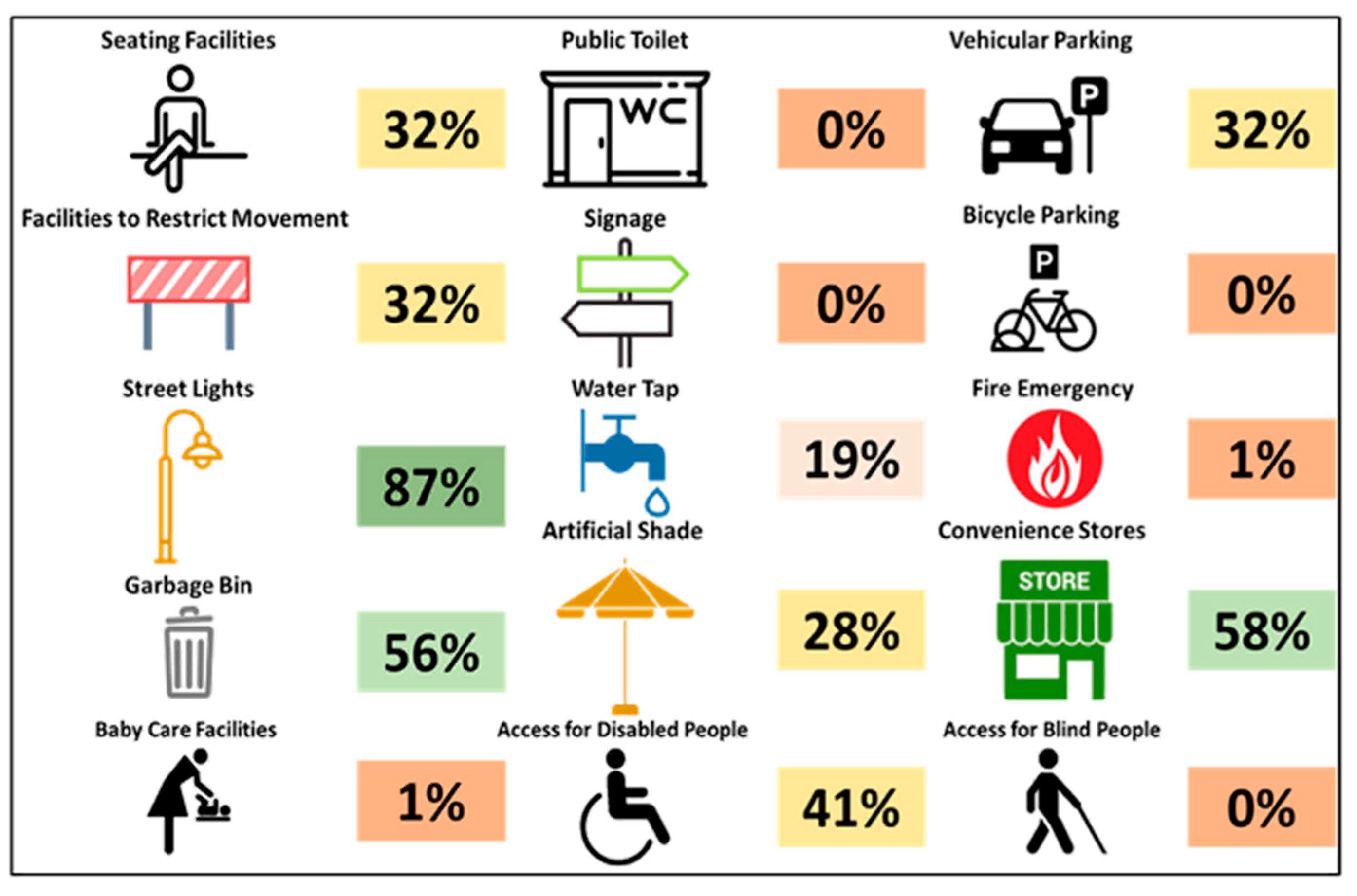
Figure 6.
Distribution of green areas in the city.
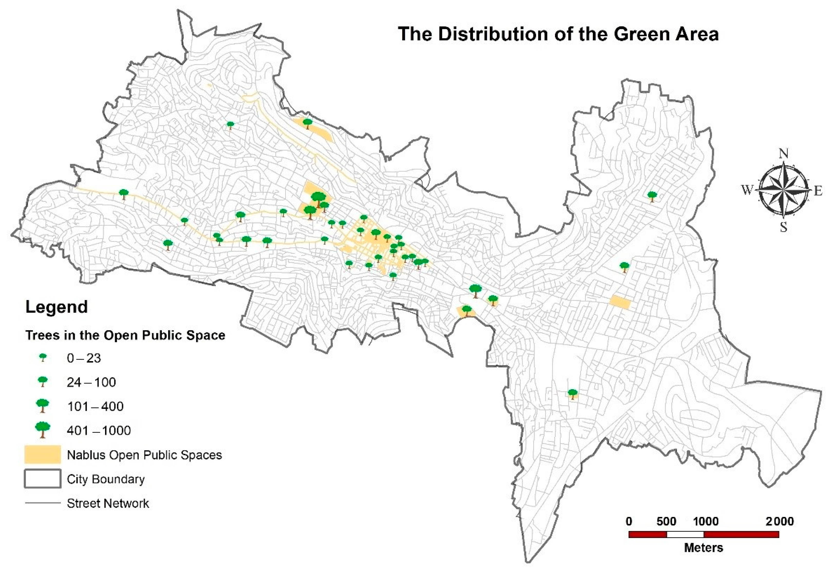
Figure 7.
General safety level by gender and time of day.
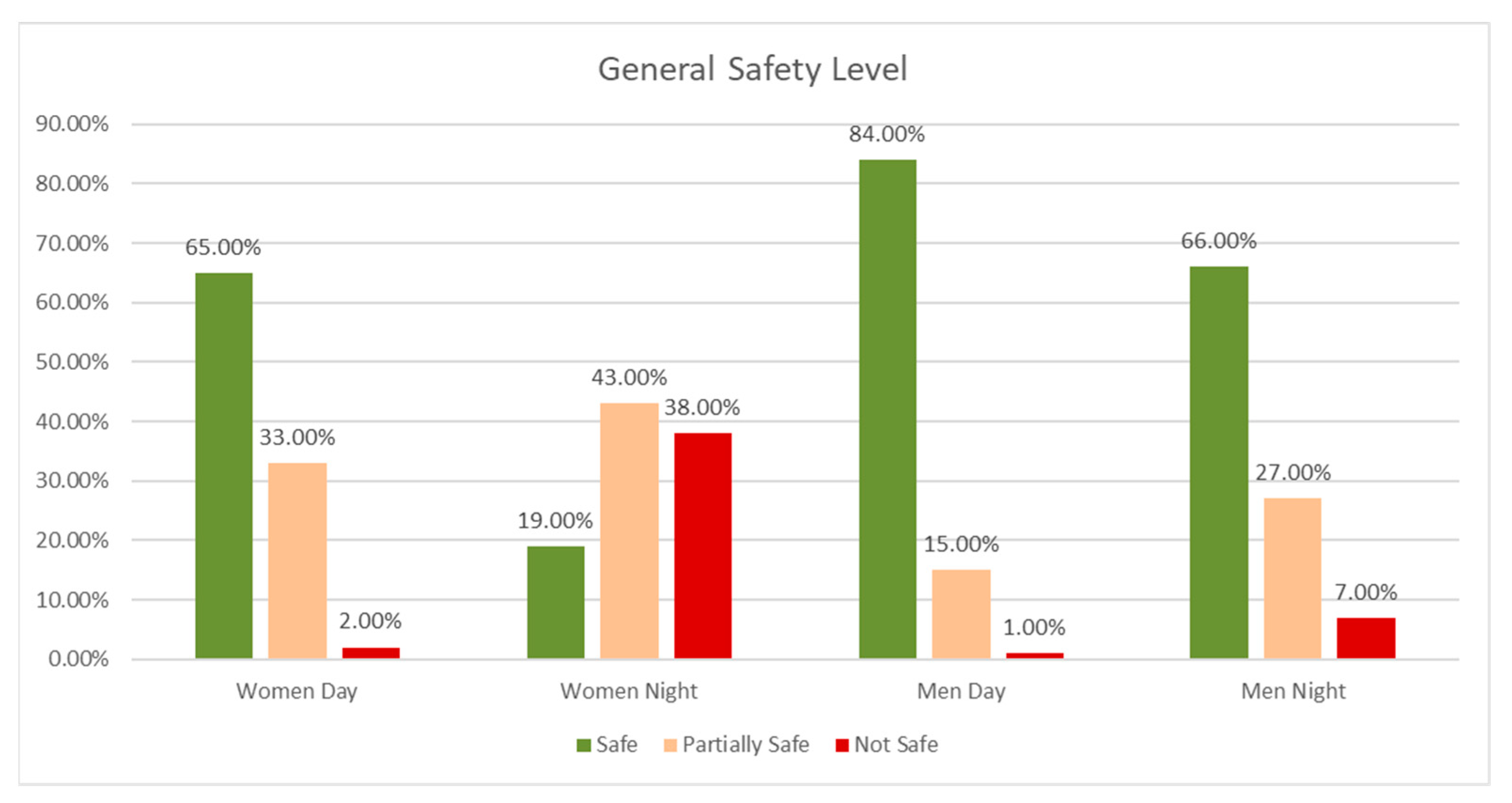
Figure 8.
Day/night users of open public spaces in the city by age group and gender.
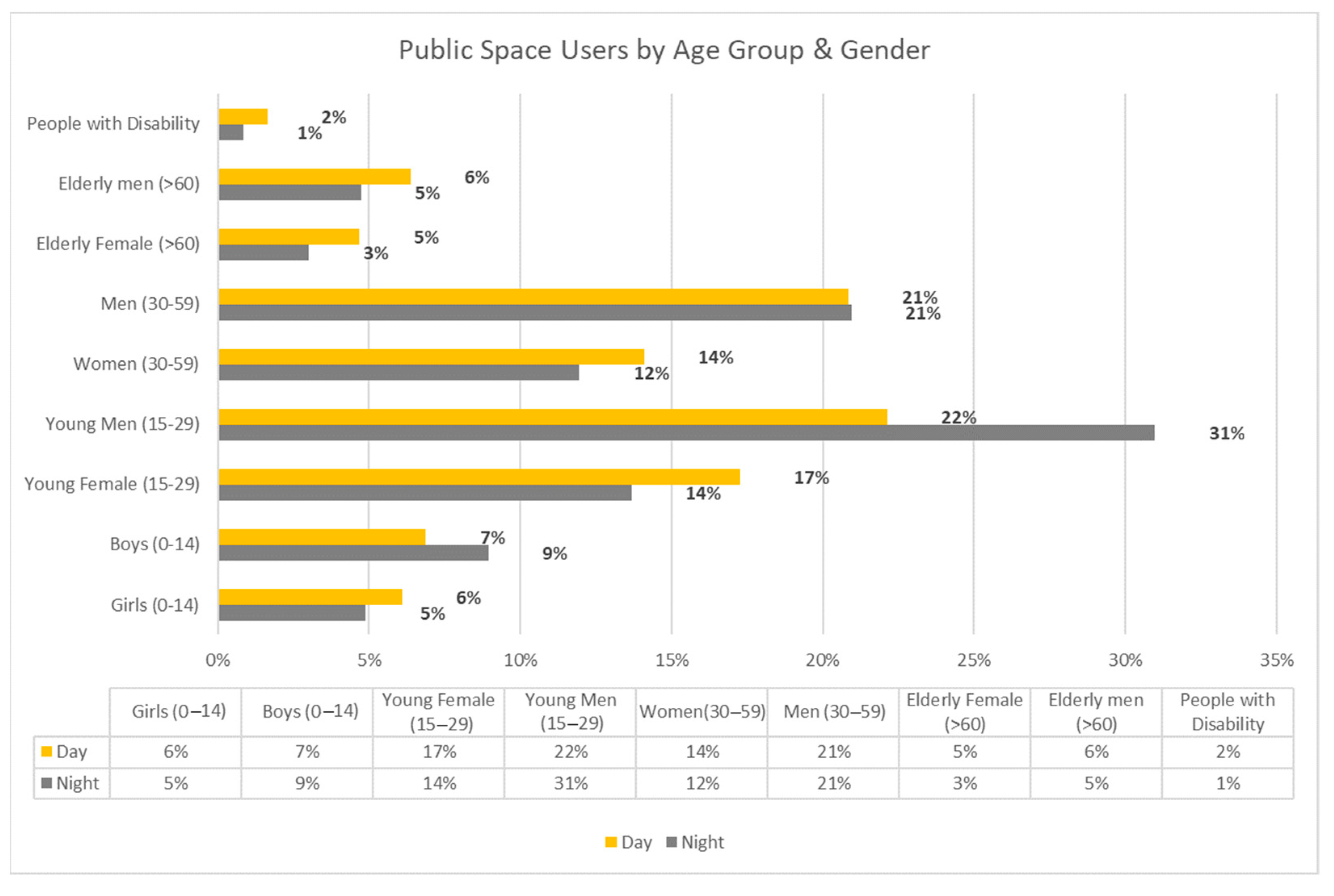
Figure 9.
Satisfaction levels with physical features in public spaces.
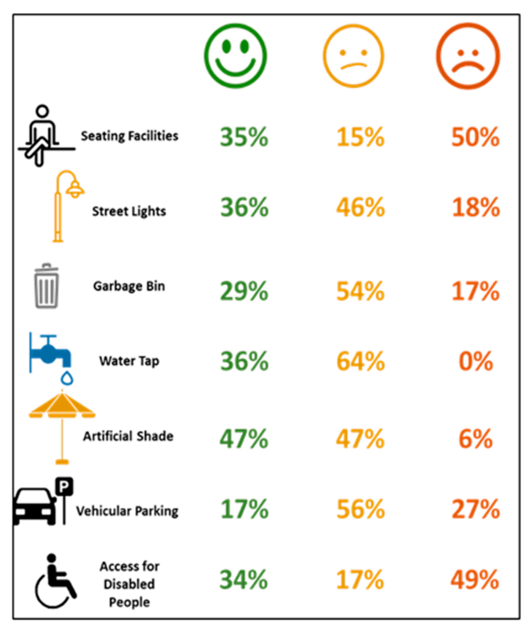
Figure 10.
The smart public space layers.

Table 1.
Indicators for inclusive public spaces.
| No. | Indicator Category | Description |
|---|---|---|
| 1 | Spatial distribution | Proximity of the public space to citizens, regardless of their residence or working location. |
| 2 | Typology | Type of public spaces: plazas, linear markets, community yards, sidewalks, recreation areas and parks, and playgrounds. |
| 3 | Facilities and services | Public space equipment and services: public toilets, seat shading, water taps, garbage bins, public lights, baby services, parking areas, and catering. |
| 4 | Green and humid areas | Ratio and distribution of green and humid areas in the public space. |
| 5 | Governance and management | Decision-making, citizens’ participation, and maintenance of resources. |
| 6 | Safety | Safety equipment, vandalism, and security measurements. |
| 7 | Users’ category | Category of the population using the public space (gender, age, disabilities). |
| 8 | Users’ satisfaction | The user’s degree of satisfaction with the public space services. |
Disclaimer/Publisher’s Note: The statements, opinions and data contained in all publications are solely those of the individual author(s) and contributor(s) and not of MDPI and/or the editor(s). MDPI and/or the editor(s) disclaim responsibility for any injury to people or property resulting from any ideas, methods, instructions or products referred to in the content. |
© 2023 by the authors. Licensee MDPI, Basel, Switzerland. This article is an open access article distributed under the terms and conditions of the Creative Commons Attribution (CC BY) license (https://creativecommons.org/licenses/by/4.0/).
Share and Cite
MDPI and ACS Style
Itair, M.; Shahrour, I.; Hijazi, I. The Use of the Smart Technology for Creating an Inclusive Urban Public Space. Smart Cities 2023, 6, 2484-2498. https://doi.org/10.3390/smartcities6050112
AMA Style
Itair M, Shahrour I, Hijazi I. The Use of the Smart Technology for Creating an Inclusive Urban Public Space. Smart Cities. 2023; 6(5):2484-2498. https://doi.org/10.3390/smartcities6050112
Chicago/Turabian StyleItair, Mohammed, Isam Shahrour, and Ihab Hijazi. 2023. "The Use of the Smart Technology for Creating an Inclusive Urban Public Space" Smart Cities 6, no. 5: 2484-2498. https://doi.org/10.3390/smartcities6050112