
The Role of Aerial Prospection for Monitoring and Preserving Cultural Heritage in Northeastern Africa

1
Department of Prehistory and Archaeology, University of Granada, 18071 Granada, Spain
2
Spanish Foundation for Science and Technology (FECYT), Ministry of Science, Innovation and Universities, 28100 Madrid, Spain
*
Author to whom correspondence should be addressed.
Heritage 2024, 7(2), 652-666; https://doi.org/10.3390/heritage7020032
Submission received: 4 December 2023
/
Revised: 22 January 2024
/
Accepted: 25 January 2024
/
Published: 31 January 2024
(This article belongs to the Special Issue Innovative Analysis Approaches and Intervention Techniques on Heritage Materials)
Abstract
:Anthropogenic and environmental processes present unique challenges for preserving cultural heritage in North Africa. Large parts of this region are characterised by unfavourable arid and semi-arid conditions and rapid changes to the landscapes caused by heightened regional development (e.g., urban expansion, road building, agricultural intensification, and socio-political conflicts). As a result, we are facing a fast-paced disappearance of heritage sites in regions that are still poorly understood. Following this, the utilisation of Earth observation data through aerial photographs and satellite imagery has emerged as an unmatched tool in the exploration of endangered archaeological heritage. Drawing on this context, this paper underscores the critical significance of incorporating digital research methods, such as remote sensing, GIS, or cartographic analysis, to ensure the evaluation and (digital) preservation of the historical sites along these vulnerable areas. Furthermore, our study seeks to provide new insights into data management and dissemination, fostering open research practices within North African archaeological research.
1. Introduction
Archaeological heritage in North Africa is intrinsically intertwined with the unique characteristics of its historical sites and the pronounced vulnerabilities stemming from anthropogenic and environmental processes. Regions in this area are characterised by vast expanses of arid and semi-arid landscapes and have undergone rapid transformations due to increasing regional development activities, including urban expansion, road construction, intensified agricultural practices, and socio-political conflicts. Moreover, they are particularly vulnerable to the effects of environmental processes such as natural erosion or alterations in coastlines accelerated by climate change [1,2,3,4]. Therefore, the preservation of heritage sites in these areas faces unparalleled challenges, leading to the rapid disappearance of cultural heritage in regions that remain poorly understood.
The research presented in this paper constitutes a crucial component of the PERAIA project, an international and collaborative endeavour involving scholars from diverse countries focusing on northeastern Africa. Methodologically, the project delivers a comprehensive remote survey based on aerial imagery, historical maps, documentary, and archaeological records to identify and evaluate North African heritage sites dating back to late prehistory and antiquity. This procedure relied heavily on legacy data and rigorous cross-verification of multiple sources that facilitated precise geospatial mapping of sites and the generation of valuable metadata, including site names, typology, chronology, coordinates and documented remains. Additionally, the dataset incorporates a specific risk assessment scale that enhances the evaluation of potential threats and categorises the dangers to which these sites are exposed. This unique feature equips us to address the dynamic and diverse environmental and human factors of the region, particularly concerning their potential impact on North African heritage.
Within the scope of this project, a groundbreaking approach to the management and dissemination of historical data was developed through the establishment of an open database and the creation of an accompanying web application. To ensure open practices’ success, all generated data must conform to the LOUD principles (linked open usable data), in terms of creation, development, and dissemination [5]. Additionally, to promote widespread sharing and reuse potential, all data are also required to comply with the FAIR principles (findable, accessible, interoperable, and reusable) [6]. This initiative seeks to promote ethical research practices that align with open science principles while also significantly expanding our understanding of the archaeo-historical landscape within these regions and the biocultural heritage that they represent.
2. Study Area
2.1. Physical Geography and Ecological Context
The area covered by this study includes territories of present-day northeastern Libya, northwestern Egypt and northern sections of the Libyan Desert (i.e., Sahara Desert within its northeastern boundaries). Nevertheless, we propose defining the region under study as “Marmarica”, a term based on biogeographical units and documentary sources. Therefore, Marmarica is a region located between the Mediterranean Sea to the north and the expansion of the Libyan Desert domains to the south. To the west, it is bounded by Cyrenaica, while to the east, it extends as far as the Qattara Depression (Figure 1) [7,8,9,10].
Marmarica comprises a diverse range of biogeographical units that are generally characterised by semi-arid and arid conditions, although these vary from north to south. These units include wadis, alluvial fans, and cultivated terrace systems on lower lateral valley slopes and tableland plains, particularly in the northern areas favoured by Mesogean influence [9,10,11,12]. In contrast, in the southern parts of the region, geography significantly influences drainage patterns, and the arid climate affects the extent and development of these systems. Ecologically dominated by the Sahara element, the southern parts of Marmarica experience decreased precipitation as we move further south, leading to increased aridity and desert conditions, resulting in a spectrum typical of steppe environments [9].
2.2. Historical and Archaeological Significance
The availability of water and vegetation determines life in semi-arid and arid landscapes and requires special knowledge of how to handle these scarce resources. These harsh conditions compel adaptation from all living beings, emphasising the importance of ecological niches. The topography, morphology, and geology of Marmarica created specific conditions in which human adaptation to these environments resulted in different human traces and impacts. This requires a comprehensive understanding of the region’s environment as a habitat, including the relationship between different social, cultural, and ethnic entities, especially of Marmarican nomadic and sedentary groups [7,9,10].
The inhabitants of the region were not simply adapted to their environments but actively transformed and culturally signified their landscapes. They constructed rainwater harvesting structures to manage rain runoff during the wet season, which optimised the water surplus, minimized the risk of flash floods, and supported agricultural areas resulting in more prominence to sedentary strategies [8,12,13,14]. Archaeological evidence suggests that such land use patterns in northern areas date back to at least the second millennium BCE and they experienced increased intensification during the Graeco-Roman period [10]. Moreover, in the southern parts, the environment favoured the development of a nomadic livelihood, utilising the limited resources of water and vegetation for pastoral activities. In such a context, the Marmarican economic activities were a combination of pastoral nomadic and sedentary strategies, using agricultural areas in the north and rangelands for livestock in arid zones to the south, indicating a long-term history of rich economic activity along the region [9,10].
A particular point of interest that represents the significance of this region in a broader context is its unique geographical location. Marmarica stands as a pivotal point between different key regions, including the Nile Valley to the east, Cyrenaica to the west, the eastern Mediterranean circuits to the north, and the interconnected oases of the hinterland to the south [15]. Trade and exchange that took place through Marmarica involved a diverse range of products—e.g., agricultural produce including dates, wine, wheat, or barley, but also animals, and other items such as salt and leather—although the trade networks across Marmarica did not just carry goods, but also people and ideas [16,17]. The mobility of people has left distinct traces on the landscape, which should be more prominent in those locations where they move and rest. Following this behavioural pattern, we can examine permanent or temporary settlements, productive areas, water catchment sites (cisterns), burial places, and more [8]. Thus, the Marmarica region stands out as a crucial nexus in the network of trade routes and cultural exchanges. Its geographical and environmental characteristics have played a key role in bridging diverse regions, from the fertile Nile Valley to the rich Cyrenaica, and from the bustling Mediterranean harbours to the fertile hinterland oases, resulting in a rich scattered cultural heritage along this region within the North African context.
3. Materials and Methods
3.1. Sources and Data Collection
The exploratory research discussed here is part of an ongoing effort to identify, characterise, and assess the anthropogenic and environmental threats to which cultural heritage is exposed. To this end, insights into the historical and environmental aspects of the region have been gained through the evaluation of historical and cartographic sources. These range from documentary and archaeological records to World War II archives, ethnographic research, and historical aerial photography combined with open-source satellite imagery (Figure 2). Therefore, the data collected provide aspects related to the Earth’s surface, including landforms (topography), water features (hydrography), and regional development (urban expansion, road construction, and agricultural intensification). This information also allowed us to identify the exact locations of ancient settlements, burial places, productive areas, historical resource catchment zones, etc. This is because these data contain information that predates the large-scale agricultural, urban, and industrial developments that have taken place in these regions since the second half of the 20th century. Consequently, they provide a valuable record of landscapes that have undergone significant changes over time or that no longer exist.
More precisely, we used a series of topographic maps produced by the U.S. Army Map Service, covering the entire study area and dating from World War II onwards. Particularly noteworthy is the P502 series, produced in 1954 at a scale of 1:250,000. This series was the first large-scale topographic mapping effort of the entire territory of North Africa and was derived from the Middle East Command maps of 1941–1942, which in turn were based on data collected by the “Survey of Egypt” in 1916 for their northeastern parts [13]. Additionally, we utilized aerial photographs taken during the same period. From 23 September to 1 November 1938, the Royal Air Force flew Hawker Hind light bomber biplanes over much of northeastern Africa to map through stereotopic photographs this strategic region in the pre-war context of World War II [18]. To assess the evolution of the region for periods after the first half of the 20th century, we also used declassified analogue satellite imagery from the KH-9 Hexagon satellite (1976), which was made available by the U.S. Geological Survey (USGS) [19,20]. This series of historical aerial photographs possesses a high ground resolution (∼6–9 m) of the study area and extended our understanding of critical areas where regional development is more pronounced.
In this study, we do not only look back into historical sources but also focus on present understandings about this region provided by the scientific community. This includes ethnohistorical data in conjunction with field information provided by archaeologists who have conducted extensive fieldwork there [9,10,12,13,14,21,22,23,24,25,26,27,28]. Finally, the use of recent high-resolution satellite imagery has also been fundamental in achieving our aims. This is mainly based on available open-source satellite imagery from diverse sources that provide regional to global coverage. The data from these sources are usually available online in the form of a web map service (WMS) that can be accessed directly from the server through a GIS platform; in our case, we used imagery from Google, Microsoft, and ESRI as basemaps.
3.2. Database Architecture
A relational database was developed in the ArcGIS environment (v. 10.5) for managing and storing the information collected related to archaeological heritage. Each recorded site was systematically linked with all its information, adhering to the variables listed in Table 1. Some of these core elements (e.g., name, typology, coordinates, or chronology) were already used in other datasets, which thus provided us with a semantic structure that we also followed for interoperability reasons. Likewise, these elements are complemented by fields specific to this project (e.g., ID, zonification number, ecological zone, documented remains, keywords, description, and associated references). We also included a validation scale based on the geolocation and available information of the sites, and a risk assessment of potential threats.
The criteria used to identify heritage sites for inclusion in the database were based on a specific timespan, covering the Late Bronze Age to the Roman period in present-day Egypt and Libya (ca. 1400 BCE–600 CE). The exclusion of sites beyond this chronology responds to the time and resources available for the project. This is exploratory research and requires further investigation.
3.3. Site Mapping Techniques
The mapping protocol was designed to technically integrate various phases and analytically combine data of different nature, thus providing a comprehensive holistic perspective of the Marmarica biocultural landscape. This approach is mainly based on a remote aerial survey to determine the presence, distribution, and preservation level of heritage sites [29,30], but it also includes computational approaches to data integration and analysis [31,32]. These methods support the comprehensive documentation and evaluation of historical records, contributing to heritage (digital) preservation.
This procedure was carried out in four stages:
- Data processing: This initial phase encompassed the analysis, processing, and transformation of the collected sources into a format suitable for further study. The conversion of historical sources to GIS-compatible formats required several preliminary steps to ensure interoperability and efficiency. We harmonized relevant data, including topographic maps, aerial photographs, and published fieldwork information. To do this, the imagery was standardized to TIFF format with LZW compression. The former allows for the visualisation of digitised analogue maps as raster images, and the latter decrease file size without compromising data quality, thereby reducing computational cost during the handling process. This comprehensive procedure ensured that historical data could be effectively managed in a GIS environment.
- Georeferencing: This second phase involved aligning raster sources with specific geographic locations based on known geospatial positions according to the coordinates of the project. To accomplish this, a preliminary analysis of the surface was conducted by examining imagery through a bird’s-eye view to evaluate topography and land cover. This further helped to delimit the study area and select landmarks. Next, all digitised historical sources, in conjunction with archaeological field data (i.e., maps, planimetries, contextual information, etc.) were overlaid and analysed using ArcGIS. However, most of these historical sources did not have a spatial reference system or were not correctly aligned with the project’s spatial coordinates. To address this, we reprojected them using control points (between 3 and 10), based on previously identified topographic landmarks. The number of control points and the transformation method were chosen based on the specificity of each historical source to be georeferenced.
- GIS techniques: In this phase, we employed remote sensing and GIS techniques to extensively analyse and interpret the geographical and environmental aspects of the study area. Initially, GIS tools (e.g., Spatial Analyst/Hydrology/Flow Accumulation, Spatial Analyst/Surface/Slope) were used to conduct a thorough hydrological and topographical assessment of the region. This approach used a digital elevation model (SRTM 30 m resolution) for mapping water bodies, assessing drainage patterns, analysing watershed accumulations and evaluating topographical features. These procedures were instrumental in gaining insights into variations in elevation and slope that had an impact on regional climatic conditions, patterns of erosion, land use and habitat distribution (offering also the possibility of monitoring future changes in all these aspects). Thus, we defined the diverse biogeographical units of the Marmarica region, which encompasses a variety of landscapes, including coastal zones, the northern tableland, the pre-Marmarican Plain, the Marmarica Plateau, and desert margins [10].
Remote aerial survey: The concluding phase focused on terrain mapping through a remote aerial survey using photo-interpretation. The study area was subdivided into a grid of 10 × 10 km cells, which were systematically surveyed by cross-checking the available sources and imagery. This framework proved to be essential in identifying subtle differences in vegetation, soil colour, and other surface elements that may indicate the presence of archaeological structures. Additionally, each identified site was represented as a point without consideration for its original extent or size, as this simplified geometry can be consistently applied to all sites regardless of the available information regarding their original dimensions (Figure 3). Ultimately, the mapping process not only allowed us to analyse the study area in great detail to identify and record sites but also enabled us to interpret these landscapes to reveal the complex interplay of natural and anthropogenic factors. This holistic perspective is essential for any further cultural heritage planning and preservation endeavours.
Historical sources are crucial to identifying cultural heritage sites and to understanding the evolution of landscapes, but they also come with inherent uncertainties. For instance, the accuracy of old maps often varies due to being affected by the technology and knowledge available at the time. Similarly, this variability is also evident in the different levels of information provided by the sources about sites. This scenario posed a challenge to our research and led us to consider how these many uncertainties can propel new approaches to mitigate their impact.
To address these challenges, specific validation scales became essential during the site mapping process (Table 2 and Table 3) [15]. These scales fulfilled two important roles. First, they established a rigorous systemisation framework that was critical for ensuring consistent and standardised sources and data handling. Most importantly, this framework enhanced the overall accuracy of the geographical location of sites and the assessment of the level of confidence in the sources used (Figure 4). This was crucial because the accuracy of a heritage site’s location can have a significant impact on the assessment of its potential threats and, subsequently, on preservation strategies. Second, the validation scales were essential in acknowledging and addressing the uncertainties inherent to the data. For example, historical maps may not only have inaccuracies but also often lack metadata explaining their creation or purpose. The validation scales provided a structured way to quantify and communicate these uncertainties. This is essential for research transparency, allowing other researchers to understand the constraints of the data and potentially reevaluate the conclusions drawn from them.
3.4. Risk Assessment
A fundamental aspect of our research was the comprehensive evaluation of threats to which heritage sites are exposed. This process involved extensive analysis during the site-mapping phase, where we used satellite imagery and historical data to identify potential risks and evaluate their proximity to documented heritage sites. This approach enabled us to determine critical areas where regional development pressures are most acute and where environmental factors can potentially lead to the destruction or alteration of cultural heritage.
The historical imagery for each site was compared against the most recent available imagery. Any observed anomalies were systematically recorded in the dataset guided by a detailed risk assessment framework (Table 4). This framework encompasses the primary threats to preserving North African heritage, stemming from anthropogenic processes (e.g., urban expansion, agricultural intensification, etc.) and environmental dynamics (e.g., natural erosion, coastline alterations, etc.). Our framework identifies each risk using a specific code that refers to its nature. It is important to note that, in our assessments, we considered a specific category defined as “conflict”. This refers to actions directly or indirectly related to armed conflict or political instability. One example is looting, which becomes more pronounced during periods of temporary political conflict [33]. Although less prevalent in our study area, this illegal activity can be easily identified in satellite imagery by the presence of illegal digging holes and ditches around sites, which pose a high risk to cultural heritage. Furthermore, we introduced a qualitative variable based on the risk likelihood scale according to different levels of potential severity. It is important to note that our approach also extends to sites that have already disappeared. In such cases, the type of risk is classified as “undetermined” because the structures are no longer visible at ground level or have been completely destroyed.
This comprehensive approach allowed us to track changes resulting from human impacts and environmental conditions around heritage sites as well as their potential effects on the deterioration of these sites over time. By doing so, we both gained insights into the current conservation state of cultural heritage and laid down a reference base for monitoring and understanding its historical evolution, which enabled a more nuanced comprehension of the factors contributing to its vulnerability and which facilitates comparisons both over time and in other contexts.
3.5. Open Data Integration
Since the conceptualization of the data model, the goal has been to find a balance between customisation and standardisation. A custom data model was key to adapting it to the research questions and increasing the inferential capacity of the model. Meanwhile, standardisation was important to align with the principles of open science and reuse stated above. Consequently, existing ontologies and published vocabularies have been taken into account in order to produce a dataset that is interoperable with other archaeological platforms and portals working with linked data.
In terms of LOUD + FAIR principles, each record has been assigned a unique identifier to make it findable. The whole dataset is publicly accessible at two URIs, to ensure redundancy: one maintained by the project at https://peraia.ugr.es/gazetteer/ (accessed on 24 January 2024) and one using the DOI protocol at https://doi.org/10.5281/zenodo.7678852 (accessed on 24 January 2024). Interoperability is ensured relying on standard and interoperable formats to represent and describe the data, and reviewing all collected records for completeness, consistency and plausibility. Reuse, which is a core principle of the project behind this research, is backed by the Creative Commons Attribution 4.0 International license applied to the dataset, which allows redistribution and reuse of a licensed work on the condition that the creator is appropriately credited and is approved for Free Cultural Works.
This approach to data management sustains the concept of heritage (digital) preservation stated above, which we use to connect the whole spectrum of actions and tools used to identify, describe, evaluate, and share data and information about heritage (from Remote Sensing to GIS, and Web publishing). Thus, preventing the loss of information about archaeological heritage, recording the potential risks they face, and providing original data to research.
4. Results and Discussion
At the conclusion of our funded project in December 2022, a total of 3352 heritage sites of Marmarica were recorded, with a chronology ranging from the Late Bronze Age to Roman times (Figure 5). Therefore, we conducted assessments of more than 3000 sites, including 188 sites that have been recorded in documentary or archaeological sources but which were either not visible in the most recent images or had already been destroyed. Assessments focused primarily on the Eastern Marmarica region (northwestern Egypt), where we identified 2717 sites, followed by the Western Marmarica region (northeastern Libya), which contributed a further 635 sites. These areas are rich in cultural heritage, with a diverse range of ancient settlements, burial places, productive areas, and historic resource catchment sites.
- -
- Eastern Marmarica (northwestern Egypt)
In the Eastern Marmarica region, a significant proportion of these heritage sites are classified as “High Risk”, indicating immediate threats primarily caused by urban development and agricultural intensification, as evidenced in the northern areas where such regional developments are more pronounced. However, the largest segment falls under the “Moderate Risk” category, suggesting the presence of large-scale environmental threats. The main reason for this is the general environmental conditions characterised by strong arid and semi-arid landscapes, resulting in significant natural erosion processes to which most of these sites are exposed to. Furthermore, a considerable number of sites have a “Low” or “Undetermined” risk level, which suggests two main situations: Either the structures that make possible identify the site in the images are not visible or they have been already destroyed (an example of the latter is very common in critical areas within the coastal zones, where—for example—hotel complexes have definitively altered the landscape) (Figure 6a).
- -
- Western Marmarica (northeastern Libya)
In Western Marmarica, the distribution of risk levels among cultural heritage sites is significantly influenced by both human activities and environmental processes. Among these sites, 429 were classified as “Moderate Risk” due to environmental factors, such as natural erosion. Conversely, 177 sites were classified as “High Risk”, largely due to anthropogenic processes, such as agricultural expansion and urban development. This pattern is similar to that observed in Eastern Marmarica, with a more pronounced impact of regional development in the northern areas. Furthermore, the presence of 29 sites classified as having “Undetermined Risk” underscores the critical need for comprehensive field evaluations (Figure 6b).
In a comparative analysis of Eastern and Western Marmarica, the distribution of risk levels among cultural heritage sites presents a challenging scenario (Figure 6). Both regions exhibit patterns in which the cultural heritage sites are threatened by anthropogenic and environmental factors, with the latter being more prevalent. These hazards are mainly characterised by natural erosion, affecting both coastal and inland sites. As elsewhere, these affections are being accelerated by climate change. In addition, high risk factors in both areas are predominantly human-induced, underscoring the impact of regional development. It is clear that since the second half of the 20th century, the northernmost areas have undergone major development marked by the growth of urban areas, the construction of transport and industrial infrastructure, and a large increase in the expansion of agricultural land. This poses an immediate threat to many of these sites. However, this situation is more pronounced in Eastern Marmarica, a territory that belongs to present-day Egypt, where such development is more pronounced than in Western Marmarica, part of present-day Libya.
These general patterns are also observed, although to a lesser scale, in the areas surrounding the hinterland oases (i.e., al-Jaghbub, Libya; Siwa and Qara, Egypt), where the identified heritage sites are more exposed to risk when their proximity to urban centres and agricultural lands is higher. In this context, it is important to consider that local development into hinterland oases could gradually increase the vulnerability of these sites (e.g., Siwa, where agricultural and salt pond exploitation are large-scale activities). The proximity to urban and agricultural expansion also increases the likelihood of indirect impacts such as changes in hydrological systems or land use patterns.
Both regions also have sites categorised as undetermined risk. This category is often based on the fact that sites have already been destroyed. It should be noted, however, that certain areas lack the necessary fieldwork to establish fine-grained risk assessments. In these cases, evaluating potential risks was occasionally challenging due to gaps in data and sources, which also made it difficult to establish a chronological framework for these sites, highlighting–once again–the need for on-field assessments. Indeed, there is a regional difference between the heritage sites identified in Eastern and Western Marmarica, exposing variations in the available sources and data for both areas. This indicates that while there are overarching patterns of similarities and distributions, the distinct regional nuances in Eastern and Western Marmarica require further investigation.
Digital practices in cultural heritage management, such as recording, storing and dissemination, are crucial for effective management, enhancing documentation and digital preservation of endangered heritage. Overall, these elements align with open data principles, which also seek to improve accessibility, widespread sharing, and reuse, promoting research transparency and collaboration. As a result of our commitment to transparency and openness in research, the comprehensive database generated has been integrated into the PERAIA website (Figure 7), maintained by the University of Granada, and it is also accessible through the Zenodo repository. As said, the database encompasses detailed information on more than 3000 archaeological sites, forming the core of our project’s research. To date, these platforms have collectively facilitated over a hundred downloads of our dataset, evidencing interest for the scientific community. The open-access nature of these data ensures their easy availability to researchers, projects and institutions, promoting a collaborative and inclusive approach to cultural heritage management.
5. Conclusions
In this article, we have provided an extensive assessment of the cultural heritage within the Marmarica region, encompassing both Eastern Marmarica (northwestern Egypt) and Western Marmarica (northeastern Libya) as key areas within the North African context. The results reveal a scenario in which a significant number of cultural heritage sites are at risk due to a combination of anthropogenic and environmental factors. The prevalent threats in both regions are natural erosion and the impacts of regional development, notably urban expansion and agricultural intensification in the northern areas; in contrast to the general threats linked to the harsh semi-arid and arid conditions further south. Moreover, our research underscores the need for comprehensive field evaluations. Despite these tangible results, this is still exploratory research; hence, our main goal is to provide a model and framework to guide future fieldwork strategies for the development of region-specific studies and interventions, especially in areas where limited field information hinders accurate assessment.
In line with our commitment to open research and collaborative cultural heritage management, we have advocated the need to adopt digital approaches and open practices to establish safe methods for documenting and preserving cultural heritage. By recognising research data as a public good we emphasise that it should be freely available instead of being hoarded through monopolistic dynamics. This also aligns with the epistemological consideration that partial data accessibility biases our research and the knowledge we generate [34]. Data sharing enables confronting biases while reinforcing informed research, as open data facilitate disciplinary interaction through the use and reuse of information and ensures transparency through the examination and reanalysis of data. Therefore, incorporating digital practices into cultural heritage management strengthens knowledge creation and fosters networking and communication across disciplines and researchers [35]. This initiative, hosted by the PERAIA project, not only promotes research transparency but also encourages widespread sharing and reutilisation of data. This approach is based on other projects in which research is eminently digital and involves extensive work on documentation, monitoring and protection strategies in the MENA (Middle East and North Africa) region [2,31,36,37,38,39]. In this context, our work is intended to support wider efforts being made to document and protect North African cultural heritage.
Author Contributions
All data have been created by D.L.-P. The results were discussed by all authors, and they contributed to the final manuscript. All authors have read and agreed to the published version of the manuscript.
Funding
This project was funded by the Spanish Ministry of Science, Innovation and Universities (FPU17/06503) and the Vice-Rectorate for Research and Knowledge Transfer of the University of Granada (Ref: PPJIB2020.18).
Data Availability Statement
All the data and associated information are available at https://peraia.ugr.es/gazetteer/(accessed on 24 January 2024) and https://zenodo.org/record/7678852 (accessed on 24 January 2024).
Acknowledgments
We are thankful to Pau de Soto from the Autonomous University of Barcelona, Borja Legarra Herrero from the Institute of Archaeology at UCL, and Tom Brughmans from UrbNet at Aarhus University for their contributions to the project.
Conflicts of Interest
The authors declare no conflict of interest. The funders had no role in the design of the study; in the collection, analyses, or interpretation of data; in the writing of the manuscript; or in the decision to publish the results.
References
- Sheldrick, N.; Zerbini, A. A Heritage Inventory for Documenting Endangered Archaeology in the Middle East and North Africa. ISPRS Ann. Photogramm. Remote Sens. Spatial Inf. Sci. 2017, IV-2/W2, 237–241. [Google Scholar] [CrossRef]
- Breen, C.; Blue, L.; Andreou, G.M.; El Safadi, C.; Huigens, H.O.; Nikolaus, J.; Ortiz-Vazquez, R.; Ray, N.; Smith, A.; Tews, S.; et al. Documenting, Protecting and Managing Endangered Maritime Cultural Heritage in the Middle East and North Africa (MENA) Region. J. Marit. Archaeol. 2022, 17, 341–352. [Google Scholar] [CrossRef]
- Westley, K.; Andreou, G.; El Safadi, C.; Huigens, H.O.; Nikolaus, J.; Ortiz-Vazquez, R.; Ray, N.; Smith, A.; Tews, S.; Blue, L.; et al. Climate Change and Coastal Archaeology in the Middle East and North Africa: Assessing Past Impacts and Future Threats. J. Isl. Coast. Archaeol. 2021, 18, 251–283. [Google Scholar] [CrossRef]
- Westley, K.; Nikolaus, J.; Emrage, A.; Flemming, N.; Cooper, A. The Impact of Coastal Erosion on the Archaeology of the Cyrenaican Coast of Eastern Libya. PLoS ONE 2023, 18, e0283703. [Google Scholar] [CrossRef] [PubMed]
- Thiery, F. Sphere 7 Data: LOUD and FAIR Data for the Research Community. Linked Geod. Work. Pap. 2019. [Google Scholar] [CrossRef]
- Wilkinson, M.D.; Dumontier, M.; Aalbersberg, I.J.J.; Appleton, G.; Axton, M.; Baak, A.; Blomberg, N.; Boiten, J.-W.; da Silva Santos, L.B.; Bourne, P.E.; et al. The FAIR Guiding Principles for Scientific Data Management and Stewardship. Sci. Data 2016, 3, 160018. [Google Scholar] [CrossRef] [PubMed]
- Rieger, A.-K.; Vetter, T.; Möller, H. The Desert Dwellers of Marmarica, Western Desert: Second Millenium BCE to First Millenium CE. In The History of the Peoples of the Eastern Desert; Barnard, H., Duistermaat, K., Eds.; The Cotsen Institute of Archaeology Press: Los Angeles, CA, USA, 2012; pp. 156–174. [Google Scholar] [CrossRef]
- Vetter, T.; Rieger, A.; Nicolay, A. Ancient Rainwater Harvesting Systems in the North-Eastern Marmarica (North-Western Egypt). Libyan Stud. 2009, 40, 9–23. [Google Scholar] [CrossRef]
- Rieger, A.-K. ‘Un-Central’ Landscapes of NE-Africa and W-Asia: Landscape Archaeology as a Tool for Socio-Economic History in Arid Landscapes. Land 2019, 8, 1. [Google Scholar] [CrossRef]
- Rieger, A.-K. Water as a Problem and a Solution in Arid Landscapes: Resilient Practices and Adapted Land Use in the Eastern Marmarica (NW-Egypt) between the 2nd Millennium BCE and the 1st Millennium CE. Land 2023, 12, 1109. [Google Scholar] [CrossRef]
- Quézel, P. Analysis of the Flora of Mediterranean and Saharan Africa. Ann. Mo. Bot. Gard. 1978, 65, 479–534. [Google Scholar] [CrossRef]
- Vetter, T.; Rieger, A.-K. Water Harvesting as a Key for Understanding Adapted Ancient Livelihoods in an Arid Environment—Approaches to Dryland Archaeology in the Eastern Marmarica (NW-Egypt). J. Arid Environ. 2019, 171, 103940. [Google Scholar] [CrossRef]
- Vetter, T.; Rieger, A.-K.; Möller, H. Water, Routes and Rangelands: Ancient Traffic and Grazing Infrastructure in the Eastern Marmarica (Northwestern Egypt). In Desert Road Archaeology in the Eastern Sahara and Beyond, Africa Praehistorica 27; Riemer, H., Förster, F., Eds.; Heinrich-Barth-Institut: Köln, Germany, 2013; pp. 455–484. [Google Scholar]
- Rieger, A.-K. The Various Ways of Being Mobile: Habitual Knowledge, Life-Strategies and the Ancient Route Networks on the Eastern Marmarica-Plateau (Northern Libyan Desert). Open Archaeol. 2017, 3, 49–68. [Google Scholar] [CrossRef]
- Laguna-Palma, D.; Toscano, M.; Rodríguez-Rellán, C. Building an Integrated Database of North-Eastern African Archaeological and Heritage Sites for Mapping Complex Social Landscapes. J. Open Archaeol. Data 2023, 11, 1–10. [Google Scholar] [CrossRef]
- Wilson, A. Saharan Trade in the Roman Period: Short-, Medium- and Long-Distance Trade Networks. Azania Archaeol. Res. Afr. 2012, 47, 409–449. [Google Scholar] [CrossRef]
- Nielsen, N. Cereal Cultivation and Nomad-Sedentary Interactions at the Late Bronze Age Settlement of Zawiyet Umm el-Rakham. Antiquity 2017, 91, 1561–1573. [Google Scholar] [CrossRef]
- Ray, N.; Nikolaus, J. Changing Urban Environments and the Impact on Coastal Cultural Heritage at Marsa Matruh, Egypt. J. Mari. Arch. 2022, 17, 445–464. [Google Scholar] [CrossRef]
- Surazakov, A.; Aizen, V. Positional Accuracy Evaluation of Declassified Hexagon KH-9 Mapping Camera Imagery. Photogramm. Eng. Remote Sens. 2010, 76, 603–608. [Google Scholar] [CrossRef]
- Dehecq, A.; Gardner, A.S.; Alexandrov, O.; McMichael, S.; Hugonnet, R.; Shean, D.; Marty, M. Automated Processing of Declassified KH-9 Hexagon Satellite Images for Global Elevation Change Analysis Since the 1970s. Front. Earth Sci. 2020, 8, 566802. [Google Scholar] [CrossRef]
- Snape, S. Walls, Wells and Wandering Merchants: Egyptian Control of Marmarica in the Late Bronze Age. In Orientalia Lovaniensia Analecta, Proceedings of the Seventh International Congress of Egyptologists, Cambridge, UK, 3–9 September 1995; Eyre, C.J., Ed.; Peeters Publishers: Leuven, Belgium, 1998; Volume 82, pp. 1081–1084. [Google Scholar]
- Snape, S. New Perspectives on Distant Horizons: Aspects of Egyptian Imperial Administration in Marmarica in the Late Bronze Age. Libyan Stud. 2003, 34, 1–8. [Google Scholar] [CrossRef]
- Snape, S. A Stroll along the Corniche? Coastal Routes between the Nile Delta and Cyrenaica in the Late Bronze Age. In Desert Road Archaeology in the Eastern Sahara and Beyond, Africa Praehistorica 27; Riemer, H., Förster, F., Eds.; Heinrich-Barth-Institut: Köln, Germany, 2013; pp. 439–454. [Google Scholar]
- Hulin, L. ‘Marmaric’ Wares: Some Preliminary Remarks. Libyan Stud. 1999, 30, 11–16. [Google Scholar] [CrossRef]
- Hulin, L. Marmaric Wares: New Kingdom and Later Examples. Libyan Stud. 2001, 32, 67–78. [Google Scholar] [CrossRef]
- Hulin, L. Western Marmarica Coastal Survey 2008: A Preliminary Report. Libyan Stud. 2008, 39, 299–314. [Google Scholar] [CrossRef]
- Hulin, L.; Timby, J.; Mutri, G. The Western Marmarica Coastal Survey 2009: Preliminary Report. Libyan Stud. 2009, 40, 179–187. [Google Scholar] [CrossRef]
- Hulin, L.; Timby, J.; Muftah, A.M.; Mutri, G. Western Marmarica Coastal Survey 2010: Preliminary Report. Libyan Stud. 2010, 41, 155–162. [Google Scholar] [CrossRef]
- Rayne, L.; Bradbury, J.; Mattingly, D.; Philip, G.; Bewley, R.; Wilson, A. From Above and on the Ground: Geospatial Methods for Recording Endangered Archaeology in the Middle East and North Africa. Geosciences 2017, 7, 100. [Google Scholar] [CrossRef]
- Rayne, L.; Gatto, M.C.; Abdulaati, L.; Al-Haddad, M.; Sterry, M.; Sheldrick, N.; Mattingly, D. Detecting Change at Archaeological Sites in North Africa Using Open-Source Satellite Imagery. Remote Sens. 2020, 12, 3694. [Google Scholar] [CrossRef]
- Wilson, A. The Use of Remote Sensing and Digital Tools for Cultural Heritage Management and Archaeological Research. Levant 2021, 53, 384–388. [Google Scholar] [CrossRef]
- Andreou, G.M.; Nikolaus, J.; Westley, K.; el Safadi, C.; Blue, L.; Smith, A.; Breen, C. Big Data in Maritime Archaeology: Challenges and Prospects from the Middle East and North Africa. J. Field Archaeol. 2022, 47, 131–148. [Google Scholar] [CrossRef]
- Casana, J.; Laugier, E.J. Satellite Imagery-Based Monitoring of Archaeological Site Damage in the Syrian Civil War. PLoS ONE 2017, 12, e0188589. [Google Scholar] [CrossRef]
- Marchetti, N.; Angelini, I.; Artioli, G.; Benati, G.; Bitelli, G.; Curci, A.; Marfia, G.; Roccetti, M. NEARCHOS. Networked Archaeological Open Science: Advances in Archaeology Through Field Analytics and Scientific Community Sharing. J. Archaeol. Res. 2018, 26, 447–469. [Google Scholar] [CrossRef]
- Pearce, N.; Weller, M.; Scanlon, E.; Kinsley, S. Digital Scholarship Considered: How New Technologies Could Transform Academic Work. Education 2010, 16, 1. [Google Scholar] [CrossRef]
- Zerbini, A. Developing a Heritage Database for the Middle East and North Africa. J. Field Archaeol. 2018, 43, S9–S18. [Google Scholar] [CrossRef]
- Andreou, G.; Blue, L.; Breen, C.; El Safadi, C.; Huigens, H.O.; Nikolaus, J.; Ortiz-Vazquez, R.; Westley, K. Maritime Endangered Archaeology of the Middle East and North Africa: The MarEA Project. Antiquity 2020, 94, e36. [Google Scholar] [CrossRef]
- Fisher, M.; Fradley, M.; Flohr, P.; Rouhani, B.; Simi, F. Ethical Considerations for Remote Sensing and Open Data in Relation to the Endangered Archaeology in the Middle East and North Africa Project. Archaeol. Prospect. 2021, 28, 279–292. [Google Scholar] [CrossRef]
- Hammer, E.; Mackinley, F.; Ur, J. Succeeding CORONA: Declassified HEXAGON Intelligence Imagery for Archaeological and Historical Research. Antiquity 2022, 96, 679–695. [Google Scholar] [CrossRef]
Figure 1.
Map showing the location of Marmarica within the northeastern Mediterranean African context (Basemap © EMODnet).
Figure 1.
Map showing the location of Marmarica within the northeastern Mediterranean African context (Basemap © EMODnet).
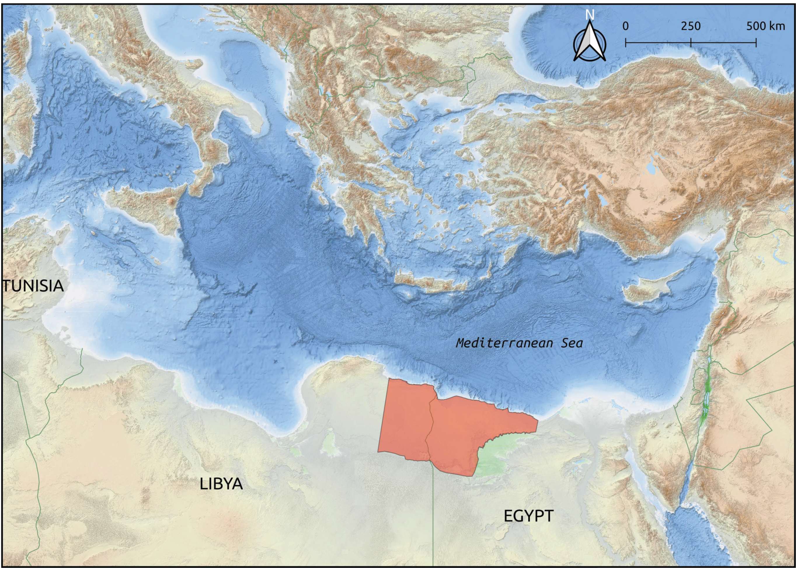
Figure 2.
Sallum Bay area (northwest Egypt) marks the northern boundary between Western and Eastern Marmarica. (A) Historical topographic maps have proven to be a valuable source for identifying archaeological heritage (P502, Sheet NH 35-1, Bardia © The University of Texas at Austin). (B) Recent open-source satellite imagery has made it possible to assess heritage sites and identify potential threats (Basemap © Microsoft).

Figure 3.
(Left) Heritage sites identified and recorded of Marmarica. (Right) A specific site, known as Zawiyet el Agdab, accompanied by its associated information within the dataset. The red dashed lines delineate possible structures associated to the main site, albeit barely visible because of natural erosion [7].
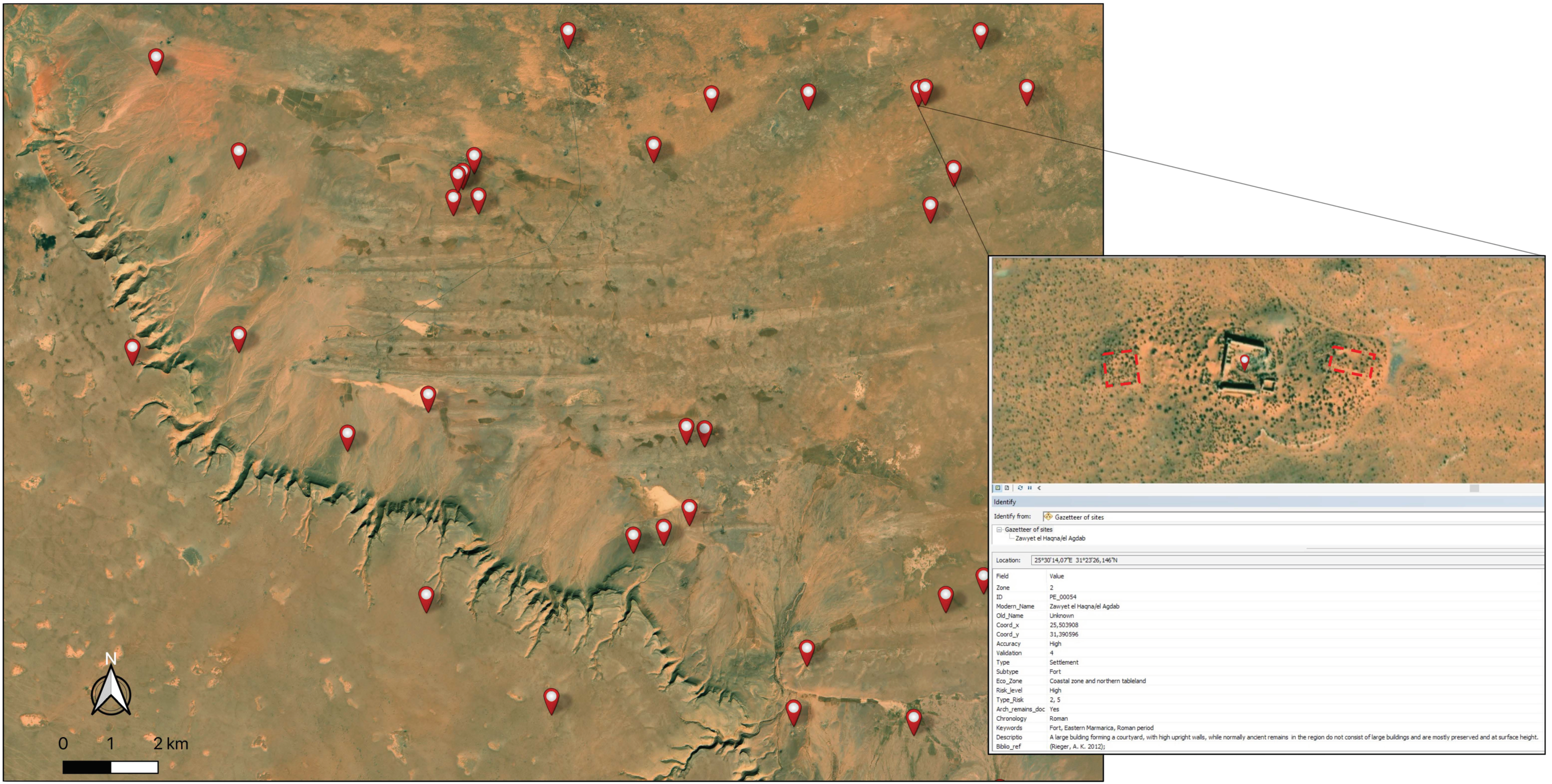
Figure 4.
Examples of archaeological heritage sites according to the variable’s accuracy and validation. Note how the site with validation “1” and “low” accuracy seems to have been destroyed by contemporary urban development [15] (p. 7).
Figure 4.
Examples of archaeological heritage sites according to the variable’s accuracy and validation. Note how the site with validation “1” and “low” accuracy seems to have been destroyed by contemporary urban development [15] (p. 7).
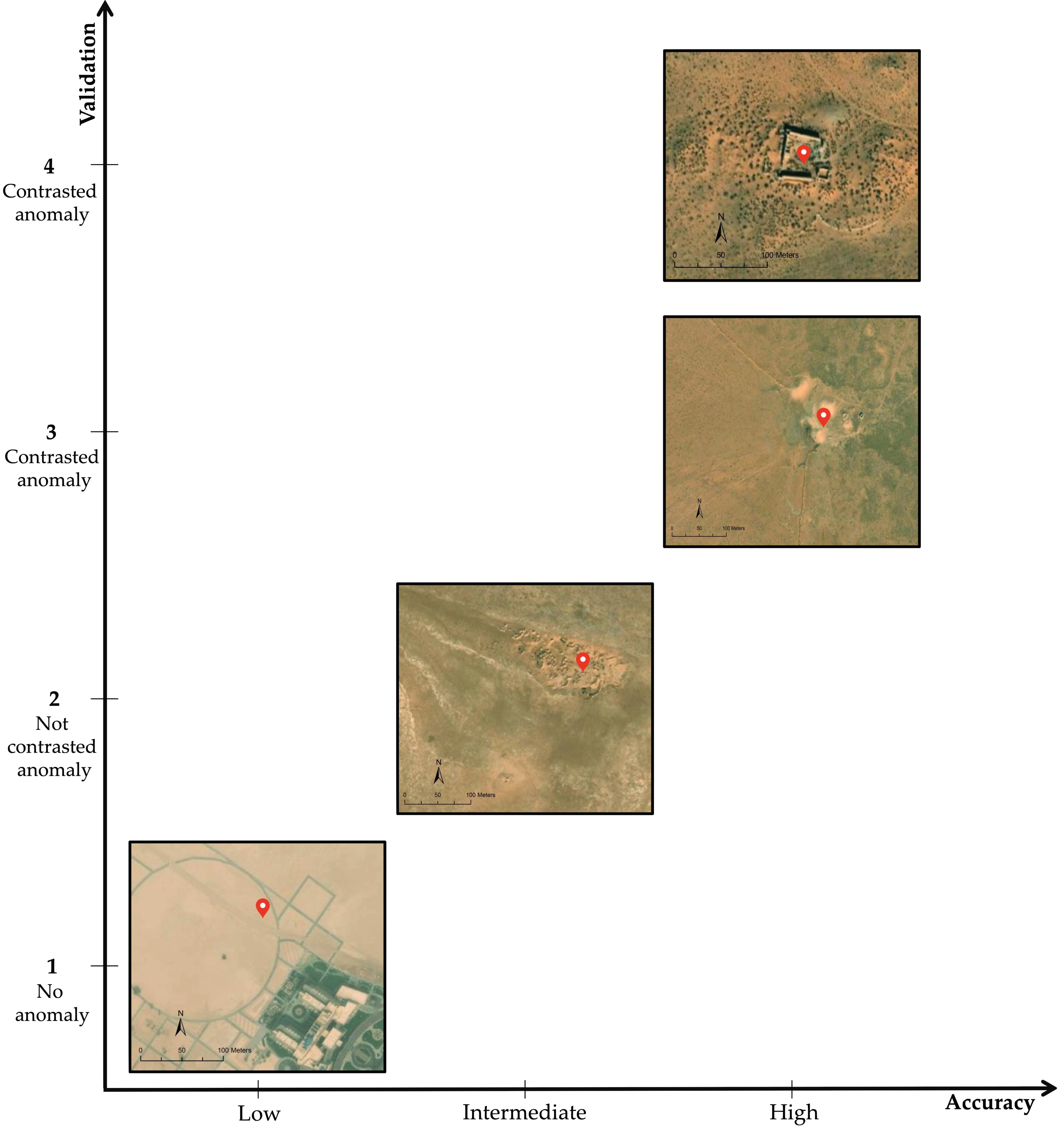
Figure 5.
Map of the Marmarica region displaying the sites documented within the framework of the PERAIA project, categorized according to their “Level of Risk”.
Figure 5.
Map of the Marmarica region displaying the sites documented within the framework of the PERAIA project, categorized according to their “Level of Risk”.

Figure 6.
Distribution of heritage sites in Eastern (a) and Western (b) Marmarica, with each category displayed as a percentage according to the risk likelihood scale.
Figure 6.
Distribution of heritage sites in Eastern (a) and Western (b) Marmarica, with each category displayed as a percentage according to the risk likelihood scale.

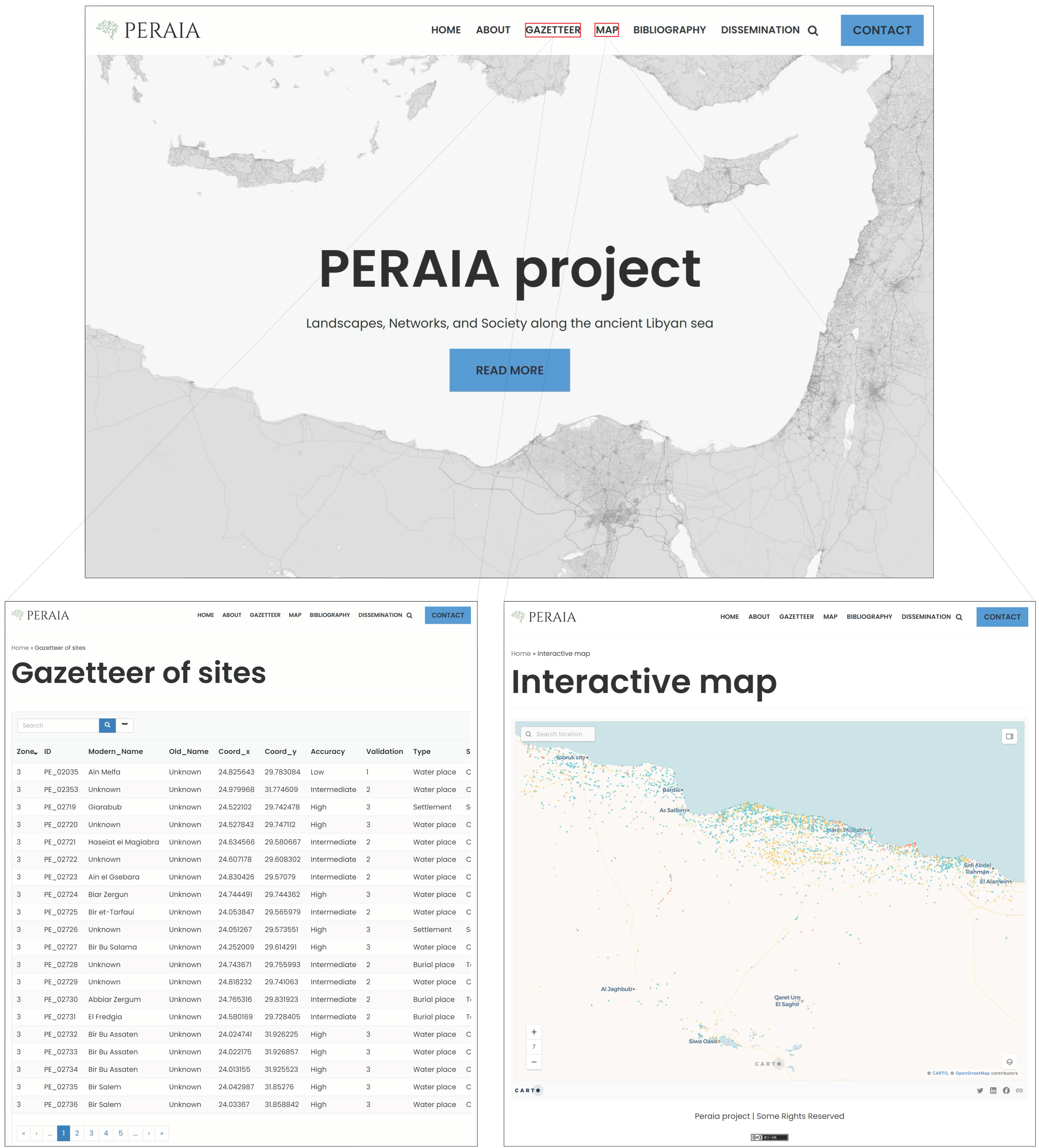
Figure 7.
The PERAIA web service interface provides access to the database and interactive map visualisation.
Figure 7.
The PERAIA web service interface provides access to the database and interactive map visualisation.

Table 1.
Database record structure.
| Variable | Type | Description |
|---|---|---|
| ID | string | This is the unique site number defined by the project (e.g., PE_00002). The two-letter prefix indicates the project name, and the following numbers identify each site |
| Zone | numeric | This number identifies the corresponding zone of a site (i.e., 2 = Eastern Marmarica/3 = Western Marmarica) |
| Modern_Name | string | Current name of the site or place |
| Old_Name | string | Ancient name of the site as documented in the sources |
| Coord_x | numeric | WGS 84/UTM zone 35N [projected] [EPSG:32635] |
| Coord_y | numeric | WGS 84/UTM zone 35N [projected] [EPSG:32635] |
| Accuracy | string | Scale that defines the accuracy of a site’s location |
| Validation | numeric | Scale that defines the level of confidence provided by the sources |
| Type | string | General typology of the sites (e.g., settlement, burial place, etc.) |
| Subtype | string | Specific typology of the sites (e.g., harbour, tomb, etc.) |
| Eco_Zone | string | Ecological zone where the site is situated |
| Risk_Level | string | Scale that defines the likelihood of destruction related to potential risks |
| Cod_Risk | string | Number that identifies the type of threats |
| Remains | dichotomous | If documented remains exist (Yes/No) |
| Chronology | string | Phases of human occupation of the sites |
| Keywords | string | Any relevant term or information used to identify the site |
| Description | string | The site description indicates the nature of the archaeological material observed, or any information related to the site |
| Biblio_ref | string | Sources used for site identification and description |
Table 2.
The variable “Accuracy” refers to the assessment of the proximity between the real location of the sites and the position defined within the framework of the project considering the precision provided by the sources.
Table 2.
The variable “Accuracy” refers to the assessment of the proximity between the real location of the sites and the position defined within the framework of the project considering the precision provided by the sources.
| Accuracy | Description |
|---|---|
| High | Anomaly detected (accurate and precise) |
| Intermediate | Anomaly detected (accurate, but not precise) |
| Low | No anomaly (neither accurate, not precise) |
Table 3.
The variable “Validation” is based on the level of confidence placed in the sources to contrast and gather information related to the sites.
Table 3.
The variable “Validation” is based on the level of confidence placed in the sources to contrast and gather information related to the sites.
| Validation | Description |
|---|---|
| 4 | Contrasted anomaly (various sources and verified on the field) |
| 3 | Contrasted anomaly (all positive evaluations, except on the field) |
| 2 | Not contrasted anomaly (cartographic data and satellite imagery) |
| 1 | No anomaly (digitisation based on sources) |
Table 4.
Risk assessment framework: the table illustrates the relationship between the likelihood of risk levels, types of potential threats, and the codes that identify each of them.
Table 4.
Risk assessment framework: the table illustrates the relationship between the likelihood of risk levels, types of potential threats, and the codes that identify each of them.
| Likelihood | Type | Code | Defining Risk |
|---|---|---|---|
| High | Urban | 6 | Urban expansion covers the construction of housing developments, industrial installations, hotel complexes, and road infrastructures |
| Agriculture | 5 | Expanding agricultural lands and developing farming practices have an impact on nearby heritage sites | |
| Conflict | 4 | Armed conflicts or political instability generate several threats to heritage, including looting (e.g., identified by illegal systematic digging holes on the sites) | |
| Moderate | Sea level rise | 3 | Sea level rise and potential coastal flooding impact areas |
| Erosion | 2 | Erosion is a natural surface process resulting from the action of wind or water flow but also accelerated by anthropic activities | |
| Low | Undetermined | 1 | It is not possible to assess the risk, either because it is not identified or because the site is destroyed |
Disclaimer/Publisher’s Note: The statements, opinions and data contained in all publications are solely those of the individual author(s) and contributor(s) and not of MDPI and/or the editor(s). MDPI and/or the editor(s) disclaim responsibility for any injury to people or property resulting from any ideas, methods, instructions or products referred to in the content. |
© 2024 by the authors. Licensee MDPI, Basel, Switzerland. This article is an open access article distributed under the terms and conditions of the Creative Commons Attribution (CC BY) license (https://creativecommons.org/licenses/by/4.0/).
Share and Cite
MDPI and ACS Style
Laguna-Palma, D.; Toscano, M.; Rodríguez-Rellán, C. The Role of Aerial Prospection for Monitoring and Preserving Cultural Heritage in Northeastern Africa. Heritage 2024, 7, 652-666. https://doi.org/10.3390/heritage7020032
AMA Style
Laguna-Palma D, Toscano M, Rodríguez-Rellán C. The Role of Aerial Prospection for Monitoring and Preserving Cultural Heritage in Northeastern Africa. Heritage. 2024; 7(2):652-666. https://doi.org/10.3390/heritage7020032
Chicago/Turabian StyleLaguna-Palma, David, Maurizio Toscano, and Carlos Rodríguez-Rellán. 2024. "The Role of Aerial Prospection for Monitoring and Preserving Cultural Heritage in Northeastern Africa" Heritage 7, no. 2: 652-666. https://doi.org/10.3390/heritage7020032