Review

Managing Sands of the Lower Mekong Basin to Limit Land Degradation: A Review of Properties and Limitations for Crop and Forage Production

1
Centre for Sustainable Farming Systems, Future Foods Institute, Murdoch University, Murdoch, WA 6150, Australia
2
Department of Agricultural Land Resources Management, General Directorate of Agriculture, No. 54B/49F, Street 395-656, Toeuk Laak 3, Tuol Kork, Phnom Penh 12158, Cambodia
3
School of Agriculture, Food and Wine, University of Adelaide, Glen Osmond, Adelaide, SA 5064, Australia
4
Cambodian Agricultural Research and Development Institute, P.O. Box 01, Phnom Penh 12413, Cambodia
*
Author to whom correspondence should be addressed.
Soil Syst. 2022, 6(3), 58; https://doi.org/10.3390/soilsystems6030058
Submission received: 7 May 2022 / Revised: 20 June 2022 / Accepted: 27 June 2022 / Published: 29 June 2022

Abstract

:
Land development is rapidly occurring on sand-dominant soils that cover substantial areas of the Lower Mekong Basin (LMB). Sands are at risk of degradation on sloping uplands where agriculture is expanding and on lowland landscapes where intensification of cropping is occurring. Sandstone and granitic geology explain the prevalence of sand-dominant textures of profiles in the LMB. However, the sand terrains in uplands of Cambodia and Southern Laos mostly have not been mapped in detail and the diversity of their edaphic properties is poorly understood. On high-permeability sands, lowland rainfed rice crops are drought-prone, while nutrient losses from leaching are also a risk. Furthermore, waterlogging, inundation and subsoil hardpans are significant hazards that influence the choice of crops and forages for lowland soils. Soil acidity, low nutrient status, hard-setting and shallow rooting depth are significant constraints for crops and forages on sands in the lowlands. Land use change in the lowlands to alternative field crops and forages on sands is contingent on their profitability relative to rice, the amounts and reliability of early wet season rainfall, and the amounts of stored water available after harvesting rice. Low soil fertility and soil acidity are limitations to the productivity of farming systems on the sand profiles in uplands, while erosion, low soil organic matter levels and water balance are concerns for their sustainable use. Site-/soil-specific fertilizer and lime management, land suitability assessment and the use of conservation agriculture principles (minimum tillage and crop residue retention) can overcome some of these constraints.

1. Introduction

Forest clearing and land use change expose soils in the Lower Mekong Basin (LMB) to degradation risks [1,2]. A large proportion of soils at risk of degradation in the LMB are sands. In sandy lowland terrain, attention is increasingly being turned to the potential for diversification of cropping systems and the prospects for more intensive land uses [3,4,5]. Of particular interest are those sands where rice productivity is low, the period of continuous soil–water saturation is short or the risk of drought is high [6]. There is also mounting pressure from the expansion of agriculture into poorly described, sandy, upland soils where there is a need to develop sustainable and profitable farming systems by alleviating land development constraints to avoid land degradation. Earlier papers reviewed some of the properties of sands of Cambodia [7] and the rice soils of Cambodia, Laos and Northeast Thailand (NET) [8]. We propose that the broader geological setting of Cambodia and Southern Laos can explain the prevalence, distribution and diversity of sands in the LMB. While regional assessments of land degradation status and risk in Southeast Asia have been reported [9,10], for the LMB, these are hampered by the lack of detailed knowledge of the soil resources, their properties and response to management. The area of lowland rainfed rice has remained relatively static over the past decade in the LMB but yields of rice have increased. In addition, irrigated lowland rice in the dry season is expanding but not substantially on sands. In Cambodia, national average rice yield has increased from 1.79 t ha−1 in 1995 to 3.30 t ha−1 in 2017 [11]. It is not known whether the increases in yield on the sand-dominant soil groups (see Table 1) have occurred at the same rate as on the loamy, clay-textured lowland soils. In contrast to rice, the area of other crops expanded markedly in Cambodia from 2002 to 2017: this has mostly occurred in upland soils (Figure 1). Prior to 2002, maize in western Cambodia was the main non-rice field crop. Most of the increase from 2002 to 2005 came from soybean and sesame expansion. From 2005 to 2009, maize and cassava accounted for most of the increase. From 2010 to 2016, the production area of cassava doubled, while the area of maize declined by 25% and the areas of other crops were stable. From 2011, areas of maize and cassava fluctuated from year to year due to market price variations, while mung bean, soybean and sesame areas have been quite stable. Much of the increase in field crop area has been in the western districts of Cambodia, driven by market demand in Thailand, while areas in the eastern Kampong Cham and Tbung Khmum provinces have also contributed significantly. It is not clear how much of the increase can be attributed to production on sands in the upland areas, but the regions of greatest recent expansion have limited sand areas.
In Southern Laos, there was a decrease in forest cover between 2006 and 2012 [1], especially in hilly areas, but much of the cleared forest was converted to rubber plantations. Again, it is unclear how much of the increase can be attributed to production on sands in the upland areas in Southern Laos.
As lowland rainfed rice production remains the dominant form of agriculture in the LMB, we firstly reviewed published work on the nature and properties of the sands in the lowlands for rice production and for cropping systems intensification with alternative field crops and forages. Then, we discussed the gaps in the knowledge base for sands in the upland areas that are already experiencing development pressure that is likely to accelerate over the next two decades. Where there are gaps in knowledge from Cambodia and Southern Laos, findings from NET were used to illustrate principles, likely constraints, relevant technologies and emerging opportunities.
The underlying hypothesis of this review is that a systematic understanding of the geology, soil properties and risks of degradation in the LMB will help farmers and public agencies to minimize land degradation as further land development occurs, especially on its widespread sandy soils.

2. Distribution of Sands in the LMB

2.1. Extent and Distribution of Sand

In Cambodia, the mapped Arenosols (deep sands featuring very weak or no soil development) cover only 1.8% of the land area [8,18]. However, there are more extensive areas of profiles with surface horizons of sand that overlie clay-rich subsoil horizons (Table 2). Amongst the more prevalent soil groups with sand-textured profiles are Acrisols (50%) and Leptosols (16%) [18,19].
Of the mapped rice soils in Cambodia [20], 39% have sand-textured surface horizons. Deep sands, such as the Prey Khmer Soil Group in the Cambodian Agronomic Soil Classification (CASC), have sand or loamy sand texture in both the surface and subsoil horizons and will be the focus of the present paper (Table 1 and Table 2) [12]. The CASC, that was adapted from the Fertility Capability Classification [21], is an agronomic soil classification that emphasizes 0–20 cm soil properties, since rice roots are relatively shallow. Even the Prey Khmer Soil Group, when used for lowland rice, is defined based on the 0–50 cm layers in the CASC [12]. There is no equivalent of the CASC in Laos and NET.
Deep sands classified as Prey Khmer have <180 g clay kg−1 and >650 g sand kg−1 in surface layers (Table 1), but often do not classify as Arenosols because the CASC only considers properties to 50 cm, whereas Arenosols should contain <180 g clay kg−1 of 100 cm depth or more (Table 1 and Table 2).
Arenosols comprise 10% of the land area in central and Southern Laos, more than fivefold higher than in Cambodia [22]. In Laos, Alisols are the major soil, comprising 50% of the soils of the main plains in Central Laos and 34% of soils in Southern Laos. Collectively, approximately half of the soils in Central and Southern Laos are Alisols and Luvisols. Other significant soil groups are: Cambisols (8–12%), Leptosols (5–8%) and Acrisols (5–8%). Unlike in Cambodia, the Acrisols are not common in Southern Laos. However, due to the scarcity of detailed soil profile descriptions and mapping in Central and Southern Laos, as well as in Cambodia, these conclusions should be treated with caution.
In Southern Laos, 75% of soils have sand, loamy sand or sandy loam textures, by contrast with only 41% in Central Laos [22]. According to Lathvilayvong et al. [24], lowland rice soils typically have a topsoil sand content exceeding 650 g kg−1, ranging as high as 850 g kg−1, with a minimum clay content of 50 g kg−1. Low organic matter content, cation exchange capacities (CEC) and percent base saturation are also common in these soils. Extractable acidity is generally high in the Acrisols and Alisols.

2.2. Geology

Sedimentary formations underlie much of Cambodia and the Khorat Plateau in NET, which also extends into Southern and Central Laos. The sediments are predominantly Mesozoic sandstone in Cambodia [25] (see Figure 2) and Cretaceous sandstone under the Khorat Plateau [26]. The sandstone and its weathering products have a dominating influence on the properties of upland soils in the region. While lowland soils are derived from alluvial, colluvial and lacustrine sediments, these are also frequently sandy materials [12,24]. In Cambodia, 39% of the lowland rice soils that have sandy surface horizons are mostly derived from the weathering and erosional products of sandstone [12].
Felsic igneous intrusions (mostly granite) that form low hills and mountains (e.g., Aoral Mountains) in South and Southeast Cambodia have also supplied siliceous sediments for the recent and older alluvial/colluvial terraces. By contrast, basaltic lava flows from the Pleistocene cover significant areas of older alluvial terraces in Eastern Cambodia, while extensive areas of basalt flows occur in Mondulkiri and Ratanakiri Provinces in Northeast Cambodia as well as the Boloven Plateau of Southeast Laos [27] and to a limited extent in NET [28]. The soils formed on the weathered basalt and their alluvial/colluvial sediments have very different properties, particularly related to nutrient and water availability, to those formed from the siliceous parent materials [12]. In the west of Cambodia, substantial areas of non-siliceous siltstone, limestone and marl occur (Figure 2) in areas that are increasingly utilized for upland crop production. Finally, the sediments deposited by the Mekong River along its flood plain and in the basin of the Tonle Sap have resulted in a large area of recent alluvial/lacustrine soils in Central Cambodia [20]. The alluvial soils on the Mekong flood plain includes sandy-loam-textured soils on the recent alluvial terraces [12].
The central and southern regions of Laos that are dominated by fine-grained red sandstone [30] include formations of siltstone and claystones as well as halite and gypsum. Older sedimentary rocks from the Jurassic and Triassic periods include light-colored sandstones, conglomerates, siltstone, claystone and limestone. Hence, throughout Southern Laos, soils are predominantly composed of fine-grained sands, but sometimes mixed with silt and clay from weathered siltstone and claystone. Finally, soils on the Mekong floodplain in Southern Laos are mainly derived from mixed alluvial deposits that reflect the Mekong Basin geology as well as more local sources of sediments.

2.3. Regional- and District-Scale Soil Resource Mapping

The sands in Cambodia or Southern Laos have not been mapped on a national scale. There is a soil resources map for the LMB (1:250,000) covering most of Cambodia and Laos, based on the FAO World Soils Map [19]. The rice-growing soils of Cambodia have been mapped using the CASC [11], based in part on an old small-scale national map (1:900,000) of soils [20]. However, the upland regions, where sandy soils are predominantly developed on sandstones and related siliceous formations, are poorly described [31]. The Cambodia Department of Agricultural and Land Resource Management (DALRM) has progressively been completing soil profile analyses with the purpose of updating the previous soil maps to a National Soil Map of Cambodia utilizing the FAO World Reference Base classification system [18].
Laos is covered by the soil map of Southeast Asia [32] at a 1:5,000,000 scale. Soil unit boundaries were based on the geological map of Indochina at 1:2,000,000 and the 1:1,000,000 USAF K-10 Operational Navigational Chart published in 1965. The Soil Survey of Laos was conducted during 1990–1995 [13] at a scale of 1:1,000,000. The outputs comprise a map and GIS dataset of 2405 soil profiles with descriptions and soil physical and chemical data attributes [33]. The soil data produced by the SSLCC [13] have been used to produce digital soil maps (DSMs) of the northern uplands of Laos but not Central or Southern Laos. Maps of a range of soil physical and chemical properties have been produced with associated land suitability maps for upland rice and rubber [34].
District-scale soil mapping has been conducted in Cambodia in Tboung Khmum Province, Takeo Province and Kampong Speu Province on sandy terrain [35,36,37]. The soil maps are supported by detailed profile descriptions, and profile chemical and physical properties, and the data are accessible in the Cambodia Soil Database at the Cambodia Agricultural Research and Development Institute (CARDI). However, these surveys only cover about 10,000 ha each. Other small areas have been mapped including social concession areas and small-scale irrigation projects (e.g., Stung Chinit Soil Survey [38]), but generally the profile descriptions are not accessible and there is no record of chemical and physical analysis to support the soil classifications. Otherwise, there is little detailed mapping or archived point-source information on soil properties for upland sand profiles of Cambodia. A soil survey program at the district and province levels by DALRM will progressively identify upland soils and contribute to the available DSMs for soil characteristics [39].

3. Limitations for Agricultural Production on Sands in Cambodia and Southern Laos
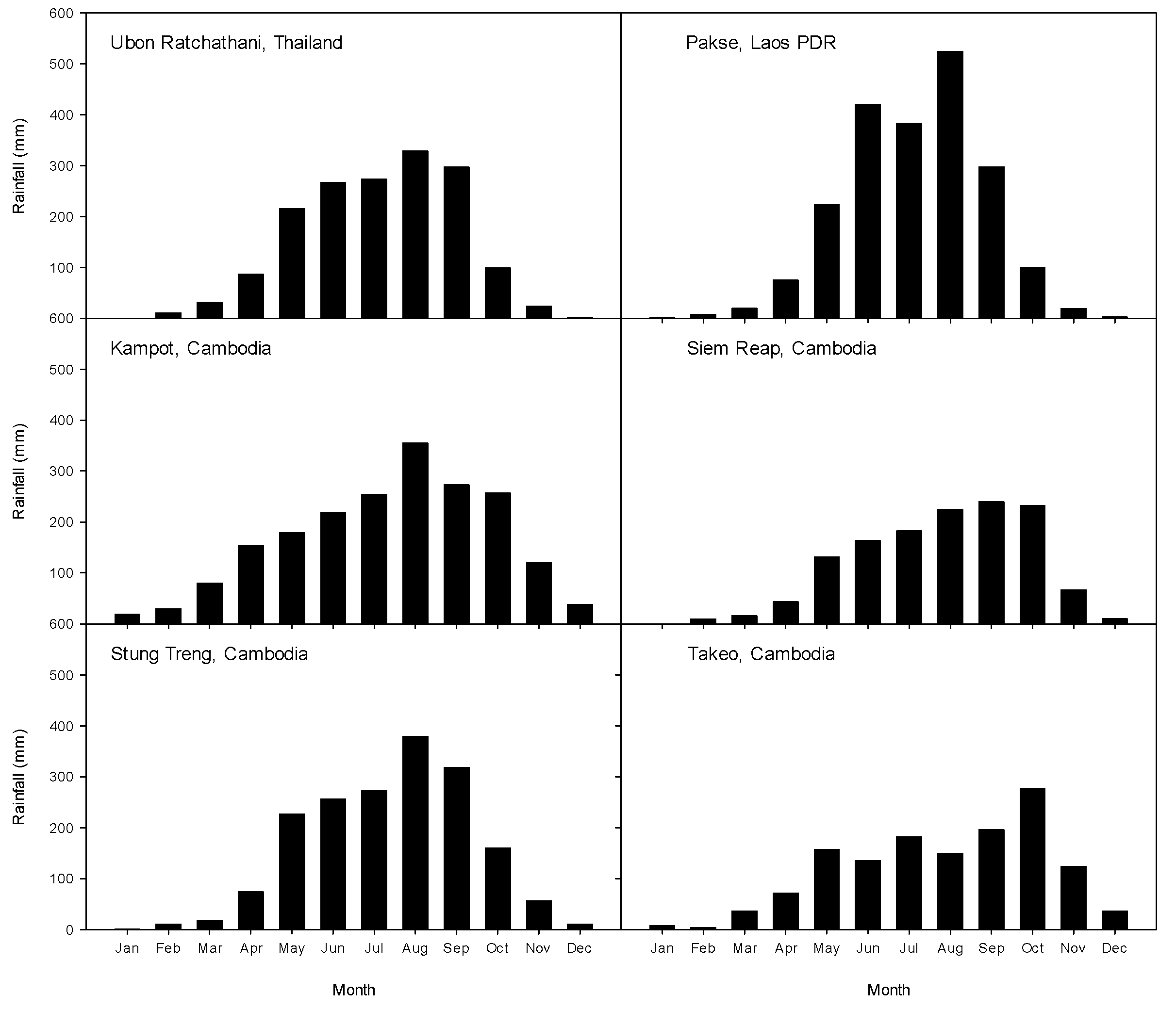
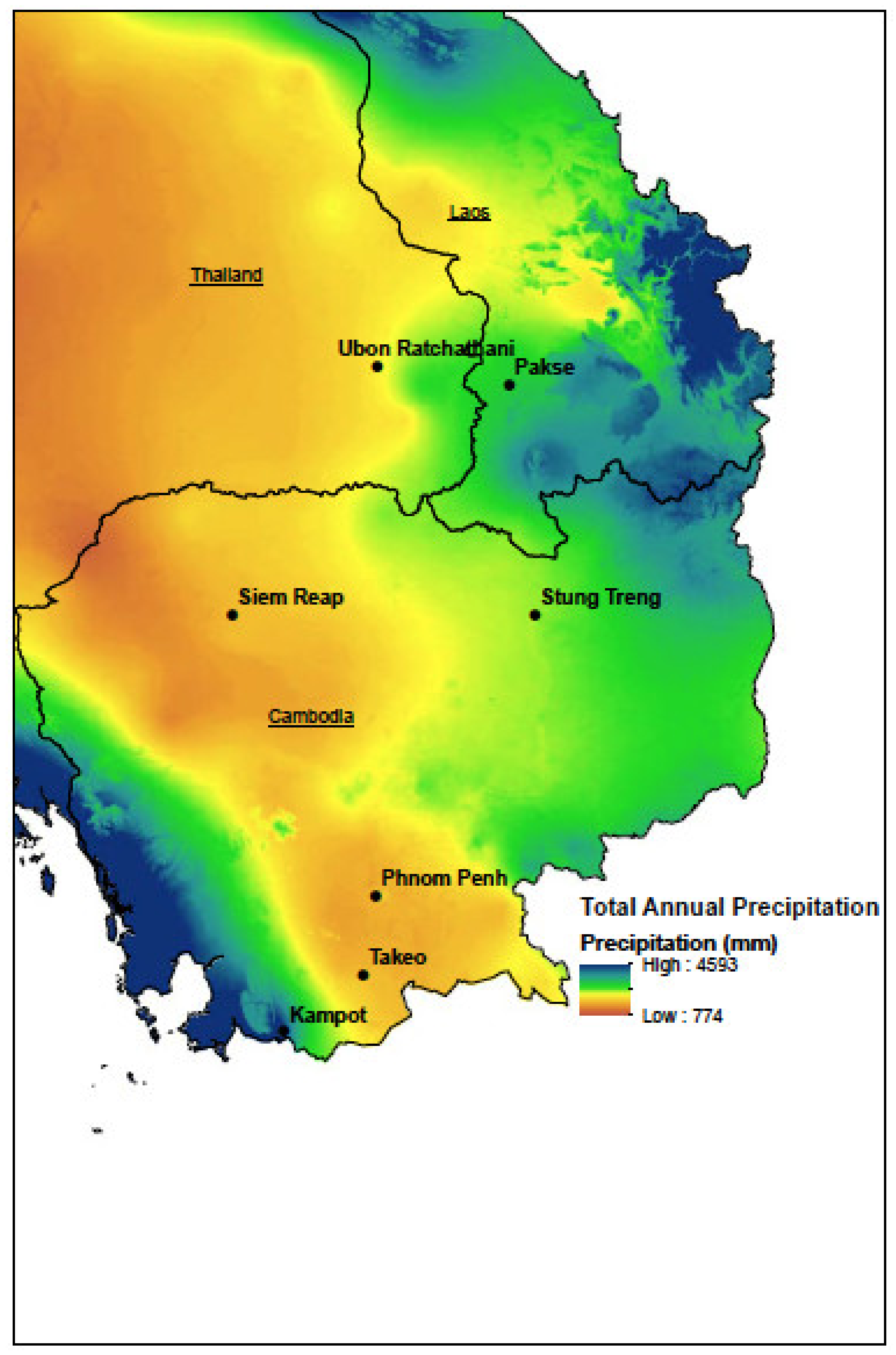
Rainfall is a key constraint for the use of sands for agriculture in Cambodia and Southern Laos due to the variability in wet season (April–October) rainfall amounts and reliability. In addition, the amounts of soil-stored water after harvesting rice and the availability of surface or groundwater for irrigation are constraints for dry-season cropping. Soil acidity and low nutrient status are additional constraints for crop production on sand in Cambodia [4,40] and in Laos [41,42].

3.1. Rainfall

For most of Cambodia, mean annual rainfall ranges from 1250 to 1750 mm (e.g., Figure 3 and Figure 4) but it increases up to 2500 mm in the south, (e.g., Kampot; Figure 3 and Figure 4), and even higher in the highlands in the east of the country [43,44]. Tsujimoto et al. [44] analyzed the distribution of annual rainfall throughout the year and concluded that 8–20% occurs in the pre-monsoon periods, 50–80% occurs in the monsoon period and 12–36% occurs in the post-monsoon period. However, there were regional differences in rainfall distribution both annually and diurnally. The variations in average annual rainfall, the average start and end date of the rainy season and its reliability have consequences for cropping patterns, and define options for pre-rice and post-rice cropping choices, especially on sands with limited soil–water storage.
While detailed modeling of the rice-growing season start and end dates has been conducted for Central Laos [45], there has been only limited analysis to determine the reliability of pre-monsoon or post-monsoon-season cropping. Vance and Bell [46] predicted sowing rules for early wet-season cropping in Southeast Cambodia. Kampot, in the high-rainfall south of Cambodia, has higher early wet season rainfall (April) than other areas and may be suitable for expanding field crops on upland sands as well as on lowland sands in the pre-rice season (Figure 3 and Figure 4). Whilst the proportion of annual rainfall attributed to the pre-monsoon period is generally low, the Cardamon Mountains area has a higher proportion of rainfall distributed in that season compared with the Pursat and Kampong Chhnang provinces [44]. In general, the annual rainfall in the lowlands of Southern Laos exceeds that of the lowlands of Cambodia, as shown in the comparison of Pakse with Siem Reap or Takeo (Figure 3 and Figure 4). The implications of these differences for pre-rice and post-rice cropping have not been explored. The rainfall patterns in Northern Cambodia at Stung Treng closely resemble those in Ubon Rathchatani, NET, which may facilitate the adoption by farmers of upland cropping patterns and soil management technologies developed in NET on sands.

3.2. Cropping Seasons

In the LMB, cropping revolves around three seasons: in Cambodia, the early wet season (EWS) lasts from April to July; the main wet season (MWS) from July to October; and the dry season (DS) from November to March [43]. For Southern Laos, the MWS starts in May and ends in October [41]. Rice is the dominant crop on lowlands in the MWS. The growing season for lowland rice ends approximately one month earlier in Southern Laos than the main rainfed lowlands of Cambodia [50]. Traditionally, transplanting occurs after sufficient rain falls for initial cultivation of soils and then for the accumulation of standing water in the fields, so that puddling and transplanting can proceed.
In recent years, due to labor shortages in Cambodia [51], direct seeding of lowland rice in the MWS has replaced transplanting in up to 90% of the planted area [52]. Rice establishment dates vary from June to late August, depending on the season and landscape position of the field. Harvesting coincides with the early part of the dry season. Dry season crops can only be planted where there is sufficient soil-stored water or where irrigation water is available. The amount of soil-stored profile water available for post-monsoon crops will vary with soil texture, landform element (lower, middle or upper landform position), the presence of compact subsoil layers and the preceding rainfall [6]. Throughout Cambodia and Southern Laos, substantial year-to-year variation in total rainfall and rainfall distribution patterns is apparent (e.g., Figure 5). The degree of annual rainfall variability means that reducing the risk of pre-monsoon and post-monsoon crop failure is an important factor in farmers’ adoption of new technologies.

4. Lowland Sands: Chemical and Physical Characteristics and Degradation Risks

4.1. Nutrient Deficiency and Depletion

In the deep sands of the lowlands (i.e., the Prey Khmer Soil Group in Cambodia), low fertility is associated with a combination of very low levels of CEC, organic C, total N, exchangeable K and Olsen P (Table 1). In Cambodia, lowland rice on sandy soils generally responds strongly to N [16], but often did not respond to N alone [12,16]. Rice yield responses to P alone have been reported, but the strongest responses generally require both N and P. On sands, K and S fertilizers often further improve rice yields. Low levels of Mg and B have also been identified as potential limiting nutrients for crops on the Prey Khmer soils, but have not been demonstrated to limit rice or other crop yields in the field [53]. Leaching of N and other nutrients may also limit productivity of these soils. The Prey Khmer soil in Cambodia has low potential productivity for wetland rice even following recommended rates of fertilizer application [12,54,55].
The responses of lowland rice to nutrients were similar in Central and Southern Laos [22]. Nitrogen was the most limiting nutrient, with 86% of experimental sites responding to N in the central and southern regions. On average, the yield increase with N fertilizer additions in the central and southern regions was 1.2 t ha–1. For rice, P deficiency was acute. Indeed, 30% of sites where rice was tested did not respond to N application unless P was applied first. This is similar to the findings in Cambodia. However, these reports relate to a period before P fertilizer application was widespread and may not reflect the current responses of rice to P fertilizer. In NET, the mean partial P balance (i.e., fertilizer P input minus outputs in harvested grain) on 12 typical farms was +7.7 kg P ha−1 year−1 from a mean input of 11 kg P ha−1 year−1 [56]. On rainfed lowland Prateah Lang soil, with added P fertilizer, there was a net P gain in the soil of 5.6 or 9.5 kg ha-1 per crop when straw was removed or returned to the soil, respectively [57]. Hence, unless there is significant P leaching, which is possible on sands [58], soil P levels should have increased over the last 20 years and P deficiency is probably less prevalent or less severe on rice fields than indicated in earlier reports. Nevertheless, P deficiency may remain a limiting factor for crops grown on soils where P fertilizer application at recommended rates has not been a regular practice. Moreover, while anoxia in wetland soils increases P availability to rice roots [59], soil P availability to dryland field crops and forages may be more limiting [60].
In Central and Southern Laos, rice yield responded to K fertilizer at 27% of sites [22]. However, over time, responses to K and a need for K inputs are expected to increase as production has increased through double cropping (wet-season and dry-season cropping) and as rice yields increase as a result of improved varieties combined with increased N and P fertilizer management and improved agronomic practices. Removal of rice straw from fields greatly increases the depletion of soil K [22]. The removal of residues of other crops such as peanut on deep sands can also cause large negative partial K balances (e.g., [61]).
Sulfur deficiency was identified in 25% of 43 on-farm omission experiments at lowland sites in central and Southern Laos but yield responses were generally small [62]. However, on sands, with similar geology and land use history, S deficiency was diagnosed by plant analysis in 35% of 633 peanut crops in NET [63]. There has been no investigation of the occurrence or prevalence of other nutrient deficiencies. However, given the similar geology and land use to NET, where deficiencies of boron, copper and molybdenum are common in legume crops [63], similar limitations may occur in Southern Laos.

4.2. Effect of Hydrology and Water Balance on Physical and Chemical Characteristics of Soils

Hydrology has a major influence on chemical and physical properties of lowland rice soils [64]. In Cambodia, Laos and NET, the shallow, drought- and submergence-prone sub-ecosystems make up 66–86% of the lowland rice ecosystems, in part due to the erratic rainfall, topography and the prevalence of sand textures in the root zone. In Laos, 33% of lowland soils have a favorable hydrology with neither drought nor submergence stress compared with only 10% in Cambodia or NET [64].
Superimposed on the sub-ecosystems, which are a useful concept for regional classifications of lowland rice growing areas, are local surface hydrology features, which can override the influence of rainfall. Within a single farm or among adjacent fields, the upper terraces, which are commonly sandy, may be classified as drought-prone sub-ecosystems, while the lower terraces, that commonly have higher clay content (Table 3), may belong to the submergence-prone or drought- and submergence-prone sub-ecosystems. Fields in the high or upper terraces of the lowlands lose large amounts of water, particularly after heavy rainfall, through surface runoff, subsurface lateral water movement and deep drainage, while those in the lower terraces may intercept the lateral flows from the upper paddies [65]. The location of farm infrastructure such as drains and bunds, and road embankments and drains under roads can markedly affect where the runoff is directed and result in localized areas of inundation risk.
Within the lowlands of the LMB, there are patches of deep sands and higher elevation land neither of which are highly suitable for rice because of the difficulty of maintaining ponded water in the paddy fields. These areas have potential for alternative land uses such as forages [5], field crops and vegetables [6]. Some of the soil constraints for field crops and forages will differ from those affecting wetland rice and so too will management strategies to avoid soil degradation.
Toposequences in NET with elevation differences of 1.5–6 m reveal further patterns of variation in soil properties across distances of 150–500 m. Homma [66] studied an area of 9.3 ha on 10 farms in the southwest of Ubon Ratchathani, and found significant variation in yield across the toposequences that correlated with variation in clay and organic matter content, flooding regimes and rice biomass. During the wet season, the duration of flooding was inversely related to elevation, while days of flooding was positively related to yield (Table 3). The lower elevation sites had higher organic matter and clay content, suggesting that the lower elevations may benefit not only from runoff water from higher elevations [65], but also have soil properties that aid soil–water retention. Oberthur and Kam [67] also report that soils in NET are typically much higher in clay and organic matter content in the lower terraces than mid and upper terraces. These patterns of variation in hydrology and soil properties are likely to exist in the lowlands of Cambodia and Southern Laos in sandy terrain.
Water balance models are useful for integrating the processes of surface hydrology experienced by rainfed rice. Fukai et al. [68] developed a water balance model for sandy soils in NET and this model has been applied to the sands of Central Laos and Cambodia. Maintaining standing water in the root zone for rice is hindered on sand by the high percolation rates in lowland rice soils of Cambodia [12], NET [65] and Central Laos [45]. Water balance modeling showed that increasing deep percolation rate from 1 to 6 mm day−1 could depress rice yield from 2.5 to 1.8 t ha−1 (Figure 6; [65]). The effects of deep percolation in rice yields are exacerbated when fields also lose water by runoff (Figure 6).
In the rainfed lowlands, loss of soil–water saturation occurs intermittently for various lengths of time during the growing season (e.g., [65,69,70]). Based on the loss of soil–water saturation and variable rainfall distribution, it is often assumed that drought is the main soil–water-related constraint for rice in the region. However, low soil–water also limits nutrient availability and uptake because variations in soil–water saturation interact with nutrient forms and accessibility [71]. Fluctuating soil–water regimes will have major effects on the forms and availability of N and P [70,72] and on Fe and Al toxicities [73]. The implications of the temporary periods of loss of soil–water saturation for nutrient availability are not fully understood [74]. Intermittent loss of soil–water saturation may also decrease the incidence and severity of Fe toxicity, which is reported to occur in Cambodia [73] and Laos [62]. In addition, loss of soil–water saturation increases the risk of Al toxicity for lowland rice on acid soils [73]. By contrast, rice roots grown under oxic (aerobic) root zone conditions experience a rapid drop in P uptake when transferred to anoxic conditions [75]. This has implications for crop nutrition when paddy fields undergo intermittent transitions between flooded and drained conditions.
Conversion of paddy fields to the production of non-rice crops and forages will have a number of implications for water balance and crop water availability. Firstly, constraints such as Al and Mn toxicity that are ameliorated by flooding of soils [59] remain as potential limitations for dryland and irrigated crops. Secondly, the repeated puddling of sandy soils for rice production produced a dense plough pan with low macroporosity [76]. Tillage to alleviate the subsoil compaction at 20–40 cm depth may have only short-term benefits for increasing root growth and yield because reconsolidation of the sand occurs [77]. The pasture legume, Stylosanthes hamata, has roots that were able to penetrate the compacted layer and after 2 years to create biopores that enhanced the root growth and yield of a subsequent maize crop [78]. Both of these examples illustrate the importance of addressing subsoil constraints on sands when converting land use from wetland rice to dryland or irrigated crops and pastures.

4.3. Land Suitability

Sands are characterized by multiple limiting factors, as demonstrated in studies in NET and South–Central Coastal Vietnam [63,79]. In the CASC, White et al. [12] summarized the main limitations for rice in each of the soil groups. Of particular relevance here are the main constraints of Prey Khmer and Prateah Lang Soil Groups for wetland rice production (Table 4). As discussed above, nutrient deficiencies are prevalent in both soils. For non-rice crops grown on the same soils when aerated, some of the same constraints apply but others change due to altered soil chemistry and the greater importance of subsoil constraints (Table 5). For non-rice crops, Seng et al. [4] developed a land suitability assessment scheme as a means of highlighting the key limitations and their relative severity for non-rice crop production. Since both Prey Khmer and Prateah Lang soils are characterized by multiple limiting factors, correct diagnosis of all the limiting factors is critical for successful management of such soils [63,79]. Some factors such as low supply of nutrients can be alleviated through the use of fertilizers. Compact subsoil may severely limit the growth of some crops, while others may be able to penetrate these layers (e.g., [78]). Other limitations are more intractable and downgrade the land suitability for crops. There has been no equivalent land suitability assessment scheme developed for Southern Laos.

5. Upland Sands: Physical and Chemical Characteristics and Degradation Risks

The properties of upland soils and their diversity in the LMB are poorly described. Hence, presently, analysis is mostly based on what is known about rice soils with similar properties in Cambodia [12] and Laos [13], and on recent studies carried out in Western Takeo province [35,80,81], Eastern Kampong Speu province [37], Tbung Khmum province (previously Kampong Cham province) [36,81], Kampot [81] and Kampong Chhnang [81], where sandy soils are prevalent. On upland soils, the main crops in Cambodia are cassava, maize, rubber, soybean, mung bean, sesame, peanut and sugarcane [17]. There is very limited information on the specific mix of crops grown on sandy upland soils of Cambodia and Southern Laos.

5.1. Soil Types

Sands similar to the Prey Khmer Soil Group are encountered in the uplands of Cambodia, with sand layers up to 80 cm in depth. A typical soil profile from upland Kampot is shown in Table 2 [81]. These soils are suitable for non-rice field crops and forages. The surface soil properties are similar to those discussed above (Table 2), with low levels of organic C, total N, Olsen-extractable P and exchangeable K, commonly found in surface layers. In addition, KCl40-extractable S levels, DTPA-extractable Cu and Zn, and hot-CaCl2-extractable B levels were low (Table 5). Other sands, up to 185 cm-deep, have been reported by Hin [81] on granitic uplands in Kampong Chhnang province. The sand grains in the deep sand profiles vary from predominantly coarse sand to predominantly fine sand, depending on the parent material.
As discussed above, the major factor likely to account for variations in upland soils in Cambodia is geology. For Southeast Cambodia, Hin [81] examined the origin of sands and concluded that in situ weathering of sandstone, granite and sedimentary soil parent materials was the major factor explaining differences in sand-dominated profiles. Some evidence of colluvial movement of weathered materials was evident based on changes in particle size distribution and sand grain roundness along toposequences associated with emergent hills. Sand profiles on granite parent rock in Kampong Chhnang province had >300 g of coarse sand (600–2000 um) kg−1. By contrast, sand profiles based on sandstone (Kampot province) and old alluvium (Tbung Khmum province) had a greater dominance of fine sand (63–200 um). More detailed surveying may identify further variations among granitic sand profiles, based on particle size of the quartz grains in the rock. Similarly, sandstone varies in composition due to shale, siltstone or conglomerate layers, which will alter the particle size distribution of the profile. Hin [81] found that some sand profiles in old alluvium parent material contained higher silt and clay contents than nearby profiles, which presumably reflects the variation in the sediment composition of alluvium. Investigations of the sandy upland soils of Southern Laos may reveal additional variation in profile types and properties, since the sandstone of the Eastern Khorat Basin is older than that in Cambodia [26].
Among sand profiles, variations of only a few percent in clay content can have quite profound effects on water and nutrient availability for crops [82]. Moreover, even small increases in clay content with depth on sands can have large effects on the amounts of plant-available, soil-stored water in the root zone, provided that root access is not hampered by Al toxicity or compaction [79]. Finally, gravel content in sands can greatly decrease plant-available water storage in the root zone [82]. Further research on the upland sands of the LMB should provide insight to subsoil properties that constrain crop and forage production in a rainfed environment where intermittent drought is common and root access to subsoil water and nutrient reserves is likely to be significant [83].

5.2. Acidity and Acidification

Soil acidity appears to be a significant factor limiting field crops in a range of upland sands in Southeast Cambodia [40]. In the deep sands of the Prey Khmer Soil Group in the western uplands of Takeo province, subsoil Al saturation values were 50–80% (Table 6), which is above the threshold of 20% that is commonly regarded as a toxic level of Al for sensitive crops (e.g., mung bean). By contrast, in very tolerant crops (e.g., cassava), >80% Al saturation impairs crop growth [84]. Seng et al. [73] showed strong responses of upland rice to lime application in acid Prateah Lang soils (pH CaCl2 4.0; Al saturation 80%) when maintained in an aerated state, whereas no response was found when those soils were flooded. Hin [81] examined lime responses of mung bean on contrasting acid sands from Kampong Chhnang (KC: coarse sand formed on granite with 2% clay), Ponhea Krek (PK: fine sand formed on old alluvium with 9% clay) and Tramkak (TK: fine sand formed on quartzite/sandstone with 2% clay). In pots, 90–95% of maximum growth of mung bean was achieved with the addition of 0.8–0.9 t of lime ha−1 in PK and 0.6–0.7 t of lime ha−1 in KC. The soil pH (CaCl2) (0–15 cm) associated with near-maximum growth was 5.3 in PK and 6.0 in KC. In unlimed sands, leaf Mn concentrations suggested severe Mn toxicity, especially in TK. Lime at 1 t ha−1 reduced Mn concentrations to values suitable for mung bean growth. Lime also strongly stimulated nodule formation in mung bean. Dry topsoil suppressed a response to lime and increased the severity of subsoil acidity effects on mung bean. In the field, incorporation of lime to at least 10 cm (TK) or 15 cm (PK) was superior to shallow incorporation for mung bean yield. In summary, strong growth responses were obtained with relatively low lime rates (0.8–1.1 t ha−1) in well-watered sands. However, multiple limitations were evident in these sands, suggesting that, in addition to lime treatments, further research on optimum fertilizer types and rates would be required to achieve high crop yields. More research is needed to distinguish between the sands that induce Mn toxicity and those that induce Al toxicity, and the relative tolerances of common crop species to these two constraints.
The prevalence of Mo deficiency for legumes also needs to be assessed in Cambodia and Southern Laos, as legumes grown in NET on similar deep sands have previously responded to Mo application [63]. In the studies by Hin [81] on acid sands, there was no indication that Ca alone was deficient, since the responses to low rates of lime could be attributed primarily to the pH change and the alleviation of either Mn or Al toxicity. Nevertheless, further assessment for Ca deficiency on acid sands is warranted.
In addition to establishing the extent of soil acidity in the LMB, the rates of acidification on sands needs to be assessed under different land use types. Sands have low pH buffering capacity and, in NET, are prone to rapid increases in acidity following the clearing of forests due to the loss of soil organic matter [85].

5.3. Water Availability

Water supply for crops is a key limiting factor for most upland areas of the LMB because of the monsoonal rainfall pattern and the erratic rainfall distribution during the EWS and MWS (Figure 2 and Figure 3). Most of the rainfed crops grown in the EWS and MWS receive less-than-optimal water supply [80].
For non-rice rainfed crops, the plant-available water content (PAWC) is a critical determinant of crop productivity. The PAWC varies markedly with soil texture [45]. On loamy sand and sand textures with <7% clay, PAWC is only 4–5 mm per 10 cm of soil depth for soils of Central Laos (Table 7). At crop water use rates of 5 mm day−1, the 0–20 cm topsoil only supplies enough water for about 2 days growth. The PAWC stored within 0–100 cm depth was only sufficient for about 8–11 days of crop water use. Hence, the sand profiles can dry rapidly and in the absence of frequent rainfall or a persistent shallow water table, dry matter production will be limited by drought, due to limited soil-stored moisture. In addition, any limitation to deep root penetration, such as subsoil Al toxicity, or compaction will further limit the PAWC available for crop growth. In the post-monsoon season, shallow-rooted legumes require supplementary irrigation to grow in sandy soils since soil-stored water is insufficient [86]. Deep sands (75–100 cm) may have a higher potential for production of deep-rooted crops and forages than for shallow-rooted crop such as rice [6] unless subsoil Al or high soil strength impede root growth and limit access to stored subsoil–water (Table 6).

5.4. Erosion

Water erosion is predicted to be a major degradation risk for upland soils in Cambodia [87]. Based on national estimates, approximately two-thirds of the Cambodian land mass is rated as moderately susceptible to erosion, especially in the higher rainfall southwest of the kingdom. The areas of moderate susceptibility comprise most of the sandy terrains of the uplands. Comparable estimates for Southern Laos have not been located. Across the LMB, there has been limited study involving direct measurement of erosion. The study by Chapalot et al. [88] in Northern Laos is an exception, but since the average land slope was 56% and the average clay content of the soils studied was 28%, the results may not be relevant to sandy uplands of the LMB.

5.5. Land Suitability

Multiple constraints can limit crop production (e.g., acidity, salinity, water-holding capacity, waterlogging), soil management (e.g., stones, erosion risk) or cause offsite environmental impacts (e.g., loss of soluble P through surface or ground water) on sands. A land suitability assessment scheme was developed for Cambodia to assess and rank limitations (Table 8; [3]). For upland crops in Cambodia, the limits for crop tolerance were aligned with those of the Fertility Capability Classification [89] which was also used for the CASC [12]. The rating of the land qualities has been modified for the soils and environments of Cambodia, based on descriptions of soil properties and limiting factors in a study by White et al. [12], soil surveys (e.g., [35,36,37]), field experiments [4] and published information for the field crops of interest [90].
The suitability of Prey Khmer and Prateah Lang Soil Groups were compared in Cambodia for peanut, mung bean, maize and soybean and compared with the suitability of crops on other soil groups [12] for EWS and MWS planting [4]. Well-managed mung bean crops with adequate fertilizer application yielded better on Prey Khmer soils than the mean yield for all soils tested (Table 9). By contrast, peanut pod yield and maize cob yields were 10–20% lower on Prey Khmer than the mean of all soils. Soybean yield was depressed by 40% on Prey Khmer relative to the mean of other soils. On Prateah Lang soil, all mung bean crops failed, while crop failure was also common for maize and soybean. The vulnerability of crops to failure on Prateah Lang is likely related to waterlogging and inundation risk from the slow drainage of subsoil clay after heavy rain but could also be due to acidity or low soil–water storage in the root zone (Table 8). Even for peanut crops which only failed in 25% of cases, the mean yield on Prateah Lang soil was only 56% of the mean for all soils.

6. Management Options for Improving Productivity and Avoiding Degradation of Sands

Due to multiple constraints, the key to productive agricultural use of sands is to diagnose the limiting constraints and develop profitable technologies to alleviate these limitations. At the same time, sands are poorly buffered, and their properties can degrade quickly in response to forest clearing and intensive use (e.g., [85]). Sustainable technologies need to maintain soil organic matter levels, avoid nutrient depletion, erosion, subsoil compaction and acidification and must correct nutrient limitations to allow high water-use efficiency on land use systems.

6.1. Crop Management and Nutrition

For Southern Laos and Cambodia, there has been no systematic study to identify the nutrient deficiencies on upland soils. However, multiple nutrient deficiencies are common on upland sands of NET [63]. Apart from N, P and K, deficiency of S, B, Cu and Mo have been reported. Sulfur and K deficiency symptoms have been observed on forages in Southern Laos and Southeast Cambodia [91]. Sulfur deficiency is common on deep sands in the south–central coastal regions of Vietnam, along with B and Cu deficiency [92,93]. Potassium has also been identified as a limitation to cassava production in Laos [94]. Hence, while there are limited reports of multiple deficiencies on sands in uplands of Southern Laos and Cambodia, given the evidence from comparable sands in the region, such deficiencies should be anticipated. The double-pot approach is a promising method to quickly survey the nutrient deficiencies of a diverse range of sands, even when laboratory facilities for soil and plant testing are limited [91,92]. With multiple nutrient deficiencies, a complete fertilizer is needed to correct all the limiting nutrients. Reliance on N and P fertilizer, which is a common practice of farmers, will not achieve yield potential on sands with multiple nutrient deficiencies [63,92]. In studies of soil-specific management of dry-season and wet-season rice in Cambodia, Kong et al. [54,55] recommended adjustments to the suggested rates of N, P and K fertilizer applied based on soil type, local conditions and season.
Apart from rice, few studies have determined the optimum or economic rates of fertilizers for crops on sands of Cambodia or Southern Laos. Interim recommendations for Cambodia have been derived from Dierolf et al. [84]. Kong et al. [55] provided indicative soil-specific application rates to achieve >75% of the profits of high-input plots for dry-season rice in Cambodia. However, responses to fertilizer alone were often poor on sands in NET unless an organic amendment was applied [95]. In addition, in Vietnam, addition of an organic amendment (biochar or cattle manure) boosted the yield of peanut regardless of whether or not inorganic fertilizer was applied. Hence, for the sands of the LMB, integrated nutrient management approaches are required for fertilizer management packages. More importantly, the most profitable packages of fertilizer and organic amendments need to be developed for smallholder farmers. On acid sands it is probably essential to include lime application for upland crops as part of the package [81].
The major shift towards direct seeding for rice establishment in Cambodia in recent years has the potential to alter soil properties and the availability of nutrients to crops. Firstly, the absence of annual soil puddling in paddy fields may alter the plough pan and soil structure. In addition, the increasing use of combine harvesters for rice retains more and taller straw in paddy fields. This may be advantageous for rice soil properties (soil structure, soil organic matter) and nutrient balance (especially K). However, there has also been an increase in demand for beef cattle, which increases the demand for rice straw as a feed source. Hence, there is a need to assess how both of these trends are being expressed on farms and to measure the medium–long-term implications for properties of sands in Cambodia. Similar trends may also emerge in Laos, since, in both countries, a shortage of farm labor is driving practice change towards labor-saving operations on farms.

6.2. Maintaining Organic Matter Levels

Approaches to maintain or enhance soil organic matter levels in sands include retention of crop residues, addition of organic matter (manure, mulch, biochar) or growing green manure crops. Retention of rice straw at 2 t ha−1 boosts lowland rainfed rice yields in Central and Southern Laos by 50% [96]. Returning rice straw also helps to maintain soil K supply, because rice straw contains 4.8 kg of K per t. However, currently, rice straw is mostly used either in situ or in feeding stalls for cattle on lowland rice farms. Some of the nutrient from straw is recycled in manure, but significant losses can occur, particularly of K. Retaining crop residues or using straw mulches also has potential to conserve water, particularly for dry-season and upland cropping on sands [86]. In Northwest Cambodia, mulch at 2.5–5 t ha−1 greatly improved the yield of maize and, to a lesser extent, sunflower [97]. While these studies were conducted on clay soils, mulches may have potential for increasing water saving and crop water use on deep sands also. Merkuria et al. [98] reported increases in water productivity for crops on sands using biochar.
When incorporated into the soil, straw or crop residues may also be beneficial to crop production on sands. In paddy fields, straw mixed into the topsoil keeps the redox potential lower during the period of soil–water saturation loss, minimizing losses in P availability due to reaction with Fe oxides [31]. Other forms of organic matter added to the soil at planting, including cow manure, or residues from pre-rice pulse crops or green manures such as Sesbania, can all help minimize losses of P during periods of soil–water saturation loss. Other options for minimizing the impact of periods of loss of soil–water saturation are the use of cultivars that are efficient in P uptake and use, and presumably would be able to cope with a temporary decline in P availability [74] and increases in soluble Al [72,73].
Some attempts have been made to grow green manure crops as an organic source of N in the wet-season lowland production system. Sesbania rostrata is the green manure crop with the most potential for this environment [24]. However, productivity of S. rostrata in much of the Mekong River valley is highly dependent on the soil P status. In Savannakhet and Champassak Provinces, the yield of S. rostrata increased from 4- to 12-fold with the application 9–13 kg of P ha–1 [99]. Linquist et al. [22] demonstrated that the P levels required for optimizing potential S. rostrata biomass production and N fixation were substantially higher than those required for rice alone on the coarse-textured soils in lowland areas of Central and Southern Laos. While farmers previously failed to adopt S. rostrata or other green manure crops as a source of organic N in the wet-season lowland production systems due to low soil P levels, there may be an opportunity to reintroduce the practice given the increase in soil P status in the last two decades. On upland soils, alternatives to S. rostrata and stylo (Stylosanthes spp.) are needed as green manures for soil improvement, or to provide fodder [78]. Alternatively, mixed-cropping systems of maize and legumes have been successful in Northern Laos [100].
Conservation agriculture involving minimum soil disturbance and crop residue retention is not commonly practiced but has a potential role in maintaining soil cover and soil organic matter levels and in erosion control on sloping land [101]. No-till and cover crops improve soil physicochemical characteristics (aggregate stability, organic carbon and cation-exchange capacity) as well as microbial abundance (total biomass, bacterial and fungal densities) in tropical grasslands of Northeast Laos [102]. Similarly, CA increased soil organic stocks by 6–28% after 5 years on an Oxisol in Cambodia [101], but results have not yet been reported for the sandy soils of the LMB.

6.3. Clay Amelioration

On the sands (3–7% clay) of NET [103], very strong responses in growth can be achieved through clay amelioration. Application of clay to sandy soils can be a semipermanent treatment to enhance water and nutrient retention [104], provided there is a readily available local supply of clay. In NET, numerous deposits of high-activity clay occur as lacustrine sediments [105]. Alternatively, where clay-rich subsoils occur, excavation and spreading of this clay may improve the properties of the sands and increase crop productivity [106]. On deep sands in Southwest Australia, clay-rich subsoils containing 30–50% clay, added to increase soil clay content from 1 to 7%, have boosted crop yields over a 15-year period by 30–50% [107]. The benefit of this technology for ameliorating the Prey Khmer (Arenosols) and the deeper phases of Prateah Lang Soil Groups of Cambodia warrants further research. In Northern Laos, Mekuria et al. [108] found that bentonite clay addition to loam soils at 10 t ha−1 improved maize growth. Sengxua et al. [109] reported benefits for crop yield at one sandy soil site in Thasano district in Savannakhet province with addition of only 1 t of bentonite ha−1. However, there were no further details reported on the longevity of responses.

6.4. Land Use Change

The subsistence production of rice in the lowlands has been the dominant land use in the LMB. However, social and economic changes occurring in the region are leading to land use changes. From 2006 to 2014, the forest cover of Cambodia declined from 59.6 to 46.9% [87]. Lowland rice farmers are leaving subsistence agriculture in favor of farming for cash income and to take advantage of off-farm employment [51]. The decline in farm labor is leading to changes from the transplanting of rice to direct seeding, for example, as mentioned above. In addition, across Asia, rice consumption per capita appears to have peaked. The demand is likely to decline over time, accelerating change in some areas to alternative crops and to livestock production to supply the market’s demand for beef. Hence, expansion, diversification and intensification of production on the sandy terrains of the LMB is likely in the future. Many of the sands that currently grow lowland rainfed rice have low suitability for a wetland crop on account of poor water storage [110]. Replacement of wetland rice is most likely on the marginal higher fields and those with sand profiles, by dryland crops, tree crops and forages [5,6]. These fields currently have a short period of water saturation and are most prone to crop drought. Instead of the cropping season being dictated by the time taken for soil–water saturation to occur [110], EWS cropping, tree crops and forage production could take advantage of the 2–3 months of pre-monsoon rainfall (see Figure 2 and Figure 3). Deep-rooted crops could also exploit more of the stored profile water than shallow-rooted rice crops, especially after the weakening of the plough pan. However, more detailed knowledge of water balance is required to underpin the development of these alternative cropping systems. In Northwest Cambodia, Montgomery et al. [97] showed that shifting the sowing dates by 2 months to avoid the period of greatest drought risk and make better use of soil-stored water in the clay soil profiles meant that it was profitable to double the crop with maize and sunflower each year. With a more detailed understanding of the water balance on deep sands and sand on clay profiles, it should be possible to design cropping patterns with higher yield potential and water-use efficiency than a single-paddy rice crop, especially on the marginal, drought-prone rice fields with sandy soils.

7. Concluding Remarks

Agricultural systems in the LMB region are undergoing rapid changes, with significant demands placed on the soil resources of this region to enable effective land use change and diversification of enterprises. The authors of [111] estimated that Laos had 3.5 million ha of land which was characterized as moderately vulnerable to desertification. In addition, 4.5 million ha of land is highly vulnerable to soil erosion in Cambodia in the southwest, while 7.6 million ha of land in the uplands of the northeast and southeast were moderately vulnerable.
A major barrier to the development of productive and sustainable management practices for sands in the LMB is the dearth of knowledge about the distribution and properties of such soils in the uplands. Land resource assessment of uplands in this region is an urgent priority for underpinning the agricultural development of these landscapes. The geographical proximity of Cambodia, Southern Laos and NET, the similarities in geology and climate and the prevalence of rainfed lowland rice as the major crop in lowland agroecosystems suggest that the crossflow of research information about sandy soils amongst these regions should be helpful. Coordination and collaboration amongst these countries could minimize duplication of research, and maximize synergies in their collective research, given the multiple constraints affecting sands across these regions. However, exchange needs to be based on a critical examination of the similarities and differences amongst them in geology, in agroecological conditions, in the prevalence of rainfed rice ecosystems and in the soils used for rice and field crop production [8].
Land resource assessment is a relatively costly investment, but a range of new sensing technologies for mapping can reduce the cost of gathering the data and the preparation of maps. Moreover, new DSM technologies can be used to prepare soil attribute maps. As demonstrated by Field and Odgers [34] and [112], the production of DSMs to create soil attribute and land suitability maps is possible with the current soil profile datasets in Laos [13]. Within Cambodia, there are many regions where more extensive soil profile datasets are required before DSMs can be produced. Land resource assessment needs to be underpinned by accessible soil–landscape databases so that point-source, detailed chemical and physical profile data are also available.
Parallel development of sustainable farming systems for the sandy uplands in the LMB is also necessary. Given the multiple limitations on sands for crop production, farming systems research needs to access cost-effective technologies for the alleviation of acidity, for erosion control, for the supply of balanced and complete nutrient supply and for the utilization of organic amendments. In addition, practices that optimize water-use efficiency and maintain water balance are critical, not only for profitability but for sustainable land management, including in areas prone to salinity. Based on the rapid rate of land use change in the LMB, there is a need for effective management of the sandy soil resources to ensure food security in the region without land degradation.

Author Contributions

Conceptualization, R.W.B.; writing—original draft preparation, R.W.B.; writing—review and editing, R.W.B., M.D.D., W.H.V., V.S., J.N.M.P., S.H., V.T.; project administration, R.W.B., M.D.D., W.H.V.; funding acquisition, R.W.B., M.D.D., W.H.V. All authors have read and agreed to the published version of the manuscript.

Funding

The research was funded by the Australian Centre for International Agricultural Research: Projects SMCN 2001/051, SMCN 2012/075 and SMCN 2016/237.

Institutional Review Board Statement

Not applicable.

Informed Consent Statement

Not applicable.

Data Availability Statement

The data presented in this study are available in the article.

Acknowledgments

The Australian Centre for International Agricultural Research that supported the research reported in the present paper, and CARDI provided facilities for the conduct of parts of the research.

Conflicts of Interest

The authors declare no conflict of interest.

References

  1. Phompilla, C.; Lewis, M.; Ostendorf, B.; Clarke, K. Forest cover changes in Lao tropical forests: Physical and socio-economic factors are the most important drivers. Land 2017, 6, 23. [Google Scholar] [CrossRef]
  2. Liao, C.; Jung, S.; Brown, D.G.; Agrawal, A. Spatial patterns of large-scale land transactions and their potential socio-environmental outcomes in Cambodia, Ethiopia, Liberia, and Peru. Land Degrad. Dev. 2020, 31, 1241–1251. [Google Scholar] [CrossRef]
  3. Bell, R.W.; Seng, V.; Schoknecht, N.; Hin, S.; Vance, W.; White, P.F. Land Capability Classification for Non-Rice Crops in Soils of the Sandy Terrain of Tram Kak District, Takeo Province. Report for ACIAR SMCN/2001/051. 2007. CARDI Soil and Water Science Technical Note No. 9. Available online: https://researchrepository.murdoch.edu.au/id/eprint/15627/1/9LandCapability-Takeo-Final1.pdf (accessed on 20 January 2022).
  4. Seng, V.; Bell, R.W.; Hin, S.; Schoknecht, N.; Vance, W.; White, P.F. Soil factors affecting crop suitability for upland crops in Cambodia. Cambodian J. Agric. 2009, 9, 24–37. [Google Scholar]
  5. Philp, J.N.M.; Vance, W.; Bell, R.W.; Ty, C.; Boyd, D.; Phimphachanhvongsod, V.; Denton, M.D. Forage options to sustainably intensify smallholder farming systems on tropical sandy soils. A review. Agron. Sustain. Dev. 2019, 39, 1–19. [Google Scholar] [CrossRef]
  6. Vial, L.K.; Molesworth, A.; Lefroy, R.D.B. Balancing rice and non-rice crops: Managing the risks from soil constraints in Mainland Southeast Asian rice systems. Field Crops Res. 2020, 246, 107677. [Google Scholar] [CrossRef]
  7. Seng, V.; Bell, R.W.; White, P.F.; Schoknecht, N.; Hin, S.; Vance, W. Sandy soils of Cambodia. In Management of Tropical Sandy Soils for Sustainable Development, Proceedings of the International Conference on the Management of Tropical Sandy Soils, Khon Kaen, Thailand, 27 November–2 December 2005; FAO: Bangkok, Thailand, 2005. [Google Scholar]
  8. Bell, R.W.; Seng, V. Rainfed lowland rice-growing soils of Cambodia, Laos, and Northeast Thailand. In Water in Agriculture, Proceedings of a CARDI International Conference on Research on Water in Agricultural Production in Asia for the 21st Century Phnom Penh, Cambodia, 25–28 November 2003; Seng, V., Craswell, E., Fukai, S., Fischer, K., Eds.; Australian Centre for International Agricultural Research: Canberra, Australia, 2004; pp. 161–173. [Google Scholar]
  9. Nachtergaele, M.; Biancalani, P.R.; Lynden, G.V.; Velthuizen, H.V.; Global Land Degradation Information System (GLADIS) Beta version. An Information database for Land Degradation Assessment at Global Level. 2010. Available online: https://www.fao.org/sustainable-forest-management/toolbox/tools/tool-detail/en/c/411197/ (accessed on 20 January 2022).
  10. Yagi, K.; Agus, F.; Arao, T.; Aulakh, M.S.; Bai, Z.; Carating, R.; Jung, K.; Kadano, A.; Kawahigashi, M.; Lee, S.H.; et al. Regional assessment of soil changes in Asia. In Status of the World’s Soil Resources (SWSR)—Main Report; Food and Agriculture Organization of the United Nations: Rome, Italy, 2015; pp. 287–329. [Google Scholar]
  11. Ministry of Agriculture, Forestry and Fisheries (MAFF). Annual Report for Agriculture, Forestry and Fisheries 2017–2018 and Direction 2018–2019. In Proceedings of the MAFF Conference, Phnom Penh, Cambodia, 30 April 2018. 113p. [Google Scholar]
  12. White, P.F.; Oberthür, T.; Pheav, S. The Soils Used for Rice Production in Cambodia: A Manual for Their Recognition and Management; International Rice Research Institute: Manila, Philippines, 1997; 71p. [Google Scholar]
  13. SSLCC. Soil Physical and Chemical Properties Analysis of Laos PDR; Soil Survey and Land Classification Center (SLCC): Vientiane, Laos, 1996. [Google Scholar]
  14. Oberthür, T.; Dobermann, A.; White, P.F. The rice soils of Cambodia. II. Statistical discrimination of soil properties by the Cambodian Agronomic Soil Classification system (CASC). Soil Use Manag. 2000, 16, 20–26. [Google Scholar] [CrossRef]
  15. White, P.F.; Dobermann, A.; Oberthür, T.; Ros, C. The rice soils of Cambodia. I. Soil classification for agronomists using the Cambodian Agronomic Soil Classification system. Soil Use Manag. 2000, 16, 12–19. [Google Scholar] [CrossRef]
  16. Seng, V.; Ros, C.; Bell, R.W.; White, P.F.; Hin, S. Nutrient requirements for lowland rice in Cambodia. In Increased Lowland Rice Production in the Mekong Region; Fukai, S., Basnayake, J., Eds.; Australia Centre for International Agricultural Research: Canberra, Australia, 2001; pp. 170–178. [Google Scholar]
  17. FAOSTAT. Food and Agriculture Organisation of the United Nations. Available online: http://faostat.fao.org (accessed on 17 January 2022).
  18. DALRM Soil Project Working Group. Development of soil resources in Cambodia (Draft): World reference base for soil resources 2014. In RDA AFACI Project: Development of Harmonized Digital Soil Information Systems and Soil Resources Atlas for Sustainable Land Management in Cambodia; Department of Agricultural Land Resources Management (DALRM), General Directorate of Agriculture, Ministry of Agriculture, Forestry and Fisheries: Phnom Penh, Cambodia, 2015. [Google Scholar]
  19. Mekong River Commission. Land Resource Inventory for Agricultural Development (Basinwide) Project. Part III Soil Database Final Report June 2002; Mekong River Commission: Phnom Penh, Cambodia, 2002. [Google Scholar]
  20. Oberthür, T.; Ros, C.; White, P.F. Soil Map of the Main Rice Growing Area of Cambodia; Cambodia–IRRI–Australia Project: Phnom Penh, Cambodia, 2000. [Google Scholar]
  21. Buol, S.W.; Sanchez, P.A.; Cate, P.A., Jr.; Granger, M.A. Soil fertility capability classification. In Soil Management in Tropical America; Bornemiza, E., Alvarado, A., Eds.; North Carolina State University: Raleigh, NC, USA, 1973; pp. 126–141. [Google Scholar]
  22. Linquist, B.; Sengxua, P.; Whitbread, A.; Schiller, J.; Lathvilayvong, P. Evaluating nutrient deficiencies and management strategies in lowland rice in Lao PDR. In Rainfed Lowland Rice: Advances in Nutrient Management Research; Ladha, J.K., Wade, L.J., Dobermann, A., Reichardt, W., Kirk, G.J.D., Piggin, C., Eds.; IRRI: Manila, Philippines, 1998; pp. 59–73. [Google Scholar]
  23. Food and Agriculture Organization for the United Nations. World Reference Base for Soil Resources; Food and Agriculture Organization for the United Nations: Rome, Italy, 1998. [Google Scholar]
  24. Lathvilayvong, P.; Schiller, J.M.; Phommasack, T. Soil limitations for rainfed lowland rice in Laos. In Breeding Strategies for Rainfed Lowland Rice in Drought Prone Environments, Proceedings of the International Workshop, Ubon Ratchathani, Thailand, 5–8 November 1996; Australian Centre for International Agricultural Research: Canberra, Australia, 1997; pp. 74–90. [Google Scholar]
  25. Workman, D.R. Geology of Laos, Cambodia, South Vietnam and the Eastern Part of Thailand—A Review; Institute of Geological Sciences: London, UK, 1972. [Google Scholar]
  26. Carter, A.; Bristow, C.S. Linking hinterland evolution and continental basin sedimentation by using detrital zircon thermochronology: A study of the Khorat Plateau Basin, eastern Thailand. Basin Res. 2003, 15, 271–285. [Google Scholar] [CrossRef]
  27. Food and Agriculture Organization of the United Nations (FAO). FAO-UNESCO Soil Map of the World. Revised Legend; World Soil Resources Report No 60; FAO: Rome, Italy, 1988; 119p. [Google Scholar]
  28. Barr, S.M.; MacDonald, A.S. Geochemistry and geochronology of late Cenozoic basalts of Southeast Asia. Geological Soc. Am. Bull. 1981, 92, 1069–1142. [Google Scholar] [CrossRef]
  29. Japan International Cooperation Agency and Department of Geology, Ministry of Energy and Mines. Explanatory Notes for the Geological and Mineral Resources Map of Lao People’s Democratic Republic, 1:1,000,000; Japan International Cooperation Agency: Tokyo, Japan, 2008; 14p. [Google Scholar]
  30. Tawornpruek, S.; Kheoruenromne, I.; Suddhiprakarn, A.; Gilkes, R.J. Microstructure and water retention of Oxisols in Thailand. Aust. J. Soil Res. 2005, 43, 973–986. [Google Scholar] [CrossRef]
  31. Seng, V.; White, P.F. History of land resource assessment in Cambodia—Lessons learned. In Proceedings of the Land Resource Assessment Forum, CARDI, Phnom Penh, Cambodia, 23–26 September 2004. [Google Scholar]
  32. Food and Agriculture Organization of the United Nations (FAO). FAO-UNESCO Soil Map of the World 1:5 000 000; Southeast Asia; The United Nations Educational, Scientific and Cultural Organization: Paris, France; FAO: Rome, Italy, 1979; Volume IX, 179p. [Google Scholar]
  33. Nyi, T.; Philip, V.; Buang, M.I.; Ra, K.; Irianta, B.; Sengxua, P.; Sipaseuth, N.; Harrah, A.A.; Jantan, B.B.; Salguero, S.M.; et al. Regional Guidelines on Soil and Nutrient Management; ASEAN Sectoral Working Group on Crops (ASWGC) on behalf of ASEAN and by the German Federal Ministry for Economic Cooperation and Development (BMZ): Bangkok, Thailand, 2017. [Google Scholar]
  34. Field, D.; Odgers, N. Soil Capability and Land Suitability, Food Security in the Northern Uplands; Discussion Paper 1; Monash University: Melbourne, Australia, 2016. [Google Scholar]
  35. Hin, S.; Schoknecht, N.; Vance, W.; Bell, R.W.; Seng, V.; Soil and Landscapes of Sandy Terrain of Tram Kak District, Takeo Province, Kingdom of Cambodia. CARDI Soil and Water Science Technical Note No. 7. 2006. Available online: https://researchrepository.murdoch.edu.au/id/eprint/15625/1/7Soil_and_Landsc_TramK-Final.pdf (accessed on 20 January 2022).
  36. Hin, S.; Bell, R.; Seng, V.; Schoknecht, N.; Vance, W. Soil and Landscapes of Basaltic Terrain in Ponhea Krek District, Kampong Cham Province, Kingdom of Cambodia; CARDI Technical Note No. 14; Soil and Water Science Division: Phnom Penh, Cambodia, 2007. [Google Scholar]
  37. Hin, S.; Bell, R.W.; Seng, V.; Schoknecht, N.; Vance, W.H. Soil and Landscapes of Sandy Terrain in Kong Pisei District, Kampong Speu Province, Kingdom of Cambodia; Technical Note No. 15; Soil and Water Science Division: Phnom Penh, Cambodia, 2007. [Google Scholar]
  38. Sanyo Consultants, Inc. Feasibility Report on the Stung Chinit Multipurpose Development Project in the Khmer Republic; Overseas Technical Cooperation Agency: Tokyo, Japan, 1971. [Google Scholar]
  39. Veng Seng (DALRM, Phnom Penh, Cambodia). Available online: https://vengsengvts.com/ (accessed on 20 January 2022).
  40. Hin, S.; Bell, R.W.; Newsome, D.; Seng, V. Understanding variability in texture and acidity among sandy soils in Cambodia. In Proceedings of the 19th World Congress of Soil Science, Soil Solutions for a Changing World, Brisbane, Australia, 1–6 August 2010; Gilkes, R.J., Prakongkep, N., Eds.; Soil Science Australia: Brisbane, Australia, 2010; pp. 236–239. [Google Scholar]
  41. Phengsavanh, P.; Phimphachanhvongsod, V. Environmental Adaptation of Forages in Lao PDR. Available online: http://wanihadi.lecture.ub.ac.id/files/2012/07/UTOMO-EROSION-FORAGE3.pdf#page=41 (accessed on 20 January 2022).
  42. Schiller, J.M.; Linquist, B.; Douangsila, K.; Inthapanya, P.; Douang Boupha, B.; Inthavong, S.; Sengxua, P. Constraints to Rice Production Systems in Laos. Available online: https://ageconsearch.umn.edu/record/135370/?ln=en (accessed on 20 January 2022).
  43. Nesbitt, H.J. Topography, climate, and rice production. In Rice Production in Cambodia; Nesbitt, H.J., Ed.; International Rice Research Institute: Manila, Philippines, 1997; pp. 15–19. [Google Scholar]
  44. Tsujimoto, K.; Ohta, T.; Aida, K.; Tamakawa, K.; So Im, M. Diurnal pattern of rainfall in Cambodia: Its regional characteristics and local circulation. Prog. Earth Planet. Sci. 2018, 5, 39. [Google Scholar] [CrossRef]
  45. Inthavong, T.; Tsubo, M.; Fukai, S. A water balance model for characterization of length of growing period and water stress development for rainfed lowland rice. Field Crops Res. 2011, 121, 291–301. [Google Scholar] [CrossRef]
  46. Vance, W.; Bell, R.W. Rainfall Analysis for the Provinces of Battambang, Kampong Cham and Takeo, The Kingdom of Cambodia. 2004. Report for ACIAR Project LWR1/2001/051. Available online: https://researchrepository.murdoch.edu.au/id/eprint/18459/ (accessed on 20 January 2022).
  47. Food and Agriculture Organization of the United Nations. CLIMWAT. Available online: http://www.fao.org/land-water/databases-and-software/climwat-for-cropwat/en/ (accessed on 14 February 2018).
  48. WorldClim-Global Climate Data Version 2. Available online: http://worldclim.org/version2 (accessed on 14 February 2018).
  49. Fick, S.E.; Hijmans, R.J. WorldClim 2: New 1-km spatial resolution climate surfaces for global land areas. Int. J. Climatol. 2017, 37, 4302–4315. [Google Scholar] [CrossRef]
  50. Fukai, S.; Ouk, M. Increased productivity of rainfed lowland rice cropping systems of the Mekong region. Crop Pasture Sci. 2012, 63, 944–973. [Google Scholar] [CrossRef]
  51. UNESCO. Policy Briefs on Internal Migration in Southeast Asia. 2018. UNESCO, Bangkok. Available online: https://bangkok.unesco.org/content/policy-briefs-internal-migration-southeast-asia (accessed on 20 January 2022).
  52. Ouk, M.; CARDI, Phnom Penh, Cambodia; Seng, V.; DALRM, Phnom Penh, Cambodia. Personal communication, 2018.
  53. Lor, B.; White, P.F.; Phaloeun, C. Nutrient Requirements for the Growth of Rice on Cambodian Soils. Available online: https://researchrepository.murdoch.edu.au/id/eprint/13626/ (accessed on 20 January 2022).
  54. Kong, K.; Hin, S.; Seng, V.; Ismail AMVergera, G.; Choi, I.-R.; Ehara, H.; Kato, Y. Potential yield and nutrient requirements of direct-seeded, dry-season rice in Cambodia. Exp. Agric. 2020, 56, 255–264. [Google Scholar] [CrossRef]
  55. Kong, K.; Hin, S.; Seng, V.; Ismail, A.M.; Vergara, G.; Choi, I.; Ehara, H.; Kato, Y. Importance of phosphorus and potassium in soil-specific nutrient management for wet-season rice in Cambodia. Exp. Agric. 2020, 56, 204–217. [Google Scholar] [CrossRef]
  56. Lefroy, R.D.B.; Konboon, Y. Studying nutrient flows to assess sustainability and identify areas of nutrient depletion and imbalance: An example for rainfed rice systems in Northeast Thailand. In Rainfed Lowland Rice: Advances in Nutrient Management Research; Ladha, J.K., Wade, L.J., Dobermann, A., Reichardt, W., Kirk, G.J.D., Piggin, C., Eds.; IRRI: Manila, Philippines, 1998; pp. 77–93. [Google Scholar]
  57. Pheav, S.; Bell, R.W.; White, P.F.; Kirk, G.J.D. Phosphorus mass balances for successive crops of fertilised rainfed rice on a sandy lowland soil. Nutr. Cycl. Agroecosyst. 2005, 73, 277–292. [Google Scholar] [CrossRef]
  58. Sharma, R.; Bell, R.W.; Wong, M.T.F. Phosphorus forms in soil solution and leachate of contrasting profiles and its implications for P mobility. J. Soil Sediment 2015, 15, 854–862. [Google Scholar] [CrossRef]
  59. Kirk, G.J.D. The Biogeochemistry of Submerged Soils; John Wiley and Sons: Chichester, UK, 2004. [Google Scholar]
  60. Seng, V.; Bell, R.W.; Willett, I.R. Effect of lime and flooding on phosphorus availability and rice growth on two acidic lowland soils. Commun. Soil Sci. Plant Anal. 2006, 37, 313–336. [Google Scholar] [CrossRef]
  61. Hoang, T.T.H.; Do, D.T.; Do, T.N.; Mann, S.; Bell, R.W. Partial potassium balance under irrigated peanut crops on sands in a tropical monsoonal climate. Nutr. Cycl. Agroecosyst. 2019, 114, 71–83. [Google Scholar] [CrossRef]
  62. Haefele, S.M.; Nilvong, S.; Sengxua, P.; Phengsouvanna, V.; Vongsouthi, S.; Linquist, B. Soil fertility management in the lowland environments. In Rice in Laos; Schiller, J.M., Chanphengxay, M.B., Linquist, B., Appa Rao, S., Eds.; IRRI: Los Banos, Philippines, 2006; pp. 369–390. [Google Scholar]
  63. Bell, R.W.; Rerkasem, B.; Keerati-Kasikorn, P.; Phetchawee, S.; Hiranburana, N.; Ratanarat, S.; Pongsakul, P.; Loneragan, J.F. Mineral Nutrition of Food Legumes in Thailand with Particular Reference to Micronutrients; ACIAR Technical Report 19; ACIAR: Canberra, Australia, 1990; 52p.
  64. Wade, L.J.; Fukai, S.; Samson, B.K.; Ali, A.; Mazid, M.A. Rainfed lowland rice: Physical environment and cultivar requirements. Field Crops Res. 1999, 64, 3–12. [Google Scholar] [CrossRef]
  65. Fukai, S.; Basnayake, J.; Cooper, M. Modelling water availability, crop growth, and yield of rainfed lowland rice genotypes in northeast Thailand. In Characterising and Understanding Rainfed Environments; Tuong, T.P., Kam, S.P., Wade, L., Pandey, S., Bouman, B.A.M., Hardy, B., Eds.; Philippines International Rice Research Institute: Los Banos, Philippines, 2000; pp. 111–130. [Google Scholar]
  66. Homma, K. Quantifying the Toposequential Distribution of Environmental Resources and Its Relationship with Rice Productivity in Rainfed Lowland in Northeast Thailand. Ph.D. Thesis, Kyoto University, Kyoto, Japan, 2002. [Google Scholar]
  67. Oberthur, T.; Kam, S.P. Perception, understanding, and mapping of soil variability in the rainfed lowlands of northeast Thailand. In Characterising and Understanding Rainfed Environments; Tuong, T.P., Kam, S.P., Wade, L., Pandey, S., Bouman, B.A.M., Hardy, B., Eds.; International Rice Research Institute: Los Banos, Philippines, 2000; pp. 75–95. [Google Scholar]
  68. Fukai, S.; Rajatsasereekul, S.; Boonjung, H.; Skulkhu, E. Simulation modelling to quantify the effect of drought for rainfed lowland rice in Northeast Thailand. In Fragile Lives in Fragile Ecosystems, Proceedings of the International Rice Research Conference, Los Baños, Philippines, 13–17 February 1995; International Rice Research Institute: Los Banos, Philippines, 1995; pp. 657–674. [Google Scholar]
  69. Seng, V.; Bell, R.W.; Nesbitt, H.J.; Willett, I.R. Response of Rainfed Rice to Inorganic and Organic Fertilizers in Southeast Cambodia. Available online: https://researchrepository.murdoch.edu.au/id/eprint/18005/ (accessed on 20 January 2022).
  70. Seng, V.; Bell, R.W.; Willett, I.R.; Nesbitt, H.J. Phosphorus nutrition of rice in relation to flooding and temporary loss of saturation in two lowland soils in south-east Cambodia. Plant Soil 1999, 207, 121–132. [Google Scholar] [CrossRef]
  71. Bell, R.W.; Ros, C.; Seng, V. Improving the efficiency and sustainability of fertiliser use in drought- and submergence-prone rainfed lowlands in Southeast Asia. In Increased Lowland Rice Production in the Mekong Region; Fukai, S., Basnayake, J., Eds.; Australian Centre for International Agricultural Research: Canberra, Australia, 2001; pp. 155–169. [Google Scholar]
  72. Seng, V. Edaphic Factors Limiting Rice Responses to Applied Inorganic Fertilizers in Rainfed Lowland Soils in Southeast Cambodia. Ph.D. Thesis, Murdoch University, Perth, Australia, 2000. [Google Scholar]
  73. Seng, V.; Bell, R.W.; Willett, I.R. Amelioration of growth reduction of lowland rice caused by a temporary loss of soil water saturation. Plant Soil 2004, 265, 1–16. [Google Scholar] [CrossRef]
  74. Fukai, S.; Inthapanya, P.; Blamey, F.P.C.; Khunthasavon, S. Genotypic variation in rice grown in low fertility soils and drought-prone, rainfed lowland environments. Field Crops Res. 1999, 64, 121–130. [Google Scholar] [CrossRef]
  75. Insalud, N.; Bell, R.W.; Colmer, T.D.; Rerkasem, B. Morphological and physiological responses of rice (Oryza sativa L.) to limited phosphorus supply in aerated and stagnant solution culture. Ann. Bot. 2006, 98, 995–1004. [Google Scholar] [CrossRef]
  76. Bruand, A.; Hartmann, C.; Ratana-Anupap, S.; Sindhusen, P.; Poss, R.; Hardy, M. Composition, fabric, and porosity of an Arenic Haplustalf of Northeast Thailand Soil. Sci. Soc. Am. J. 2004, 68, 185–193. [Google Scholar]
  77. Hartmann, C.; Poss, R.; Janeau, J.L.; Bourdon, E.; Lesturgez, G.; Ratana-Anupap, S. Use of the granular material theory to interpret structural changes in a sandy soil. In Proceedings of the 17th World Congress of Soil Science, Bangkok, Thailand, 14–21 August 2002. [Google Scholar]
  78. Lesturgez, G.; Poss, R.; Hartmann, C.; Bourdon Enoble, A.D.; Ratana-Anupap, S. Roots of Stylosanthes hamata create macropores in the compact layer of a sandy soil. Plant Soil 2004, 260, 101–109. [Google Scholar] [CrossRef]
  79. Bell, W.R.; Chon, N.Q.; Cong, P.T. Soil Types, Properties and Limiting Factors in South-Central Coastal Vietnam. Available online: https://researchrepository.murdoch.edu.au/id/eprint/28484/ (accessed on 20 January 2022).
  80. Bell, R.W.; Seng, V.; Schoknecht, N.; Vance, W.; Hin, S. Assessing land suitability for crop diversification in Cambodia. In Proceedings of the Land Resource Assessment Forum, CARDI, Phnom Penh, Cambodia, 23–26 September 2004. [Google Scholar]
  81. Hin, S. Acid Sands of South-Eastern Cambodia: Their Origin, Properties and Management for Upland Crops. Ph.D. Thesis, Murdoch University, Perth, Australia, 2018. [Google Scholar]
  82. Scanlan, C.A.; Holmes, K.W.; Bell, R.W. Chapter 10. Sand and gravel subsoils. In Subsoil Constraints for Crop Production; Oliveira, T.S., Bell, R.W., Eds.; Springer Nature: Chennai, India, 2022. [Google Scholar]
  83. Bell, R.W.; Oliveira, T.S. Chapter 16. Subsoil constraints for crop production: Recent advances, new technologies and priorities for further research. In Subsoil Constraints for Crop Production; Oliveira, T.S., Bell, R.W., Eds.; Springer Nature: Chennai, India, 2022. [Google Scholar]
  84. Dierolf, T.; Fairhurst, T.; Mutert, E. Soil Fertility Kit. A Toolkit for Acid, Upland Soil Fertility Management in Southeast Asia; GTZ-GmbH: Bonn, Germany; FAO: Rome, Italy; PT Jasa Katom: Bukittinggi, Indonesia; PPI/PPIC: San Francisco, CA, USA, 2001. [Google Scholar]
  85. Noble, A.D.; Gillman, G.P.; Ruaysoongnern, S. A cation exchange index for assessing degradation of acid soil by further acidification under permanent agriculture in the tropics. Eur. J. Soil Sci. 2000, 51, 233–243. [Google Scholar] [CrossRef]
  86. Eastick, R.; Seng, V.; Ouk, M.; Chea, S.; Som, B.; Chea, V.; Mitchell, J.; Fukai, S. Development of sustainable legume production in rice-based farming systems in Cambodia. In Food Security from Sustainable Agriculture, Proceedings of the 15th Australian Agronomy Conference, Australian Society of Agronomy, Lincoln, New Zealand, 15–18 November 2010; The Regional Institute: Gosford, Australia, 2010. [Google Scholar]
  87. Ministry of Agriculture, Forestry and Fisheries. Land Degradation Neutrality—Target Setting Program; National Report on LDN Target Setting Program; Ministry of Agriculture, Forestry and Fisheries: Phnom Penh, Cambodia, 2018; 35p. [Google Scholar]
  88. Chaplot, V.; Rumpel, C.; Valentin, C. Water erosion impact on soil and carbon redistributions within uplands of Mekong River. Glob. Biogeochem. Cycles 2005, 19, 1–13. [Google Scholar] [CrossRef]
  89. Sanchez, P.A.; Palm, C.A.; Buol, S.W. Fertility capability soil classification: A tool to help assess soil quality in the tropics. Geoderma 2003, 114, 157–185. [Google Scholar] [CrossRef]
  90. Sys, C.; van Ranst, E.; Debaveye, J.; Beernaert, F. Land Evaluation. Part III: Crop Requirements; Agricultural Publications No. 7; General Administration for Development Cooperation: Brussels, Belgium, 1993. [Google Scholar]
  91. Philp, J.M.N.; Cornish, P.; Kim, S.H.T.; Bell, R.W.; Vance, W.; Lim, V.; Li, X.; Kamphayae, S.; Denton, M.D. Insufficient potassium and sulfur supply threatens the productivity of smallholder perennial forage grasses on tropical sandy soils. Plant Soil 2021, 461, 617–630. [Google Scholar] [CrossRef]
  92. Hoang, M.T.; Nhan, D.T.; Nguyen, T.T.; Hoang, V.; Hoang, T.T.H.; Chen, W.; Thinh, T.; Dinh, Q.L.; Mann, S.; Bell, R.W. Diagnosing Multiple Nutrient Deficiencies that Limit Crop Growth and Yields on Sands in South Central Coast of Vietnam. Available online: https://researchrepository.murdoch.edu.au/id/eprint/28485/ (accessed on 20 January 2022).
  93. Hoang, T.T.H.; Do, D.T.; Nguyen, H.N.; Nguyen, V.B.; Mann, S.; Bell, R.W. Sulfur management strategies to improve partial sulfur balance with irrigated peanut production on deep sands. Arch. Agron. Soil Sci. 2021, 67, 1465–1478. [Google Scholar] [CrossRef]
  94. Chua, M.F.; Youbee, L.; Oudthachit, S.; Khanthavong, P.; Veneklaas, E.J.; Malik, A.I. Potassium fertilization is required to sustain cassava yield and soil fertility. Agronomy 2020, 10, 1103. [Google Scholar] [CrossRef]
  95. Ragland, J.; Boonpukdee, L. Fertilizer responses in northeast Thailand. I. Literature review and rationale. Thai J. Soils Fertil. 1987, 9, 65–79. [Google Scholar]
  96. Sengxua, P.; Linquist, B. On-farm residue effects on rainfed rice productivity in Laos. In Proceedings of the 17th World Congress of Soil Science, Bangkok, Thailand, 14–21 August 2002; pp. 1–8. [Google Scholar]
  97. Montgomery, S.C.; Tighe, M.K.; Guppy, C.; Wright, G.; Flavel, R.J.; Phan, S.; Im, S.; Martin, R.J. Yield responses of maize and sunflower to mulch under no-till farming conditions in Northwest Cambodia. Asian J. Crop Sci. 2016, 8, 71–86. [Google Scholar] [CrossRef]
  98. Merkuria, W.; Noble, A.; McCartney, M.; Hoanh, C.T.; Douangsavanh, S.; Langan, S. Soil management for raising crop water productivity in rainfed production systems in Lao PDR. Arch. Agron. Soil Sci. 2016, 62, 53–68. [Google Scholar] [CrossRef]
  99. Schiller, J.M.; Lathvilayvong, P.; Phommasack, T. Current use of and requirements for sustainable food production in the Lao PDR. In Nutrient Management for Sustainable Crop Production in Asia; Johnston, A.E., Syers, J.K., Eds.; CAB International: Wallingford, UK, 1998; pp. 321–332. [Google Scholar]
  100. Lienhard, P.; Lestrelin, G.; Phanthanivong, I.; Kiewvongphachan, X.; Leudphanane, B.; Lairez, J.; Quoc, H.T.; Castella, J.-C. Opportunities and constraints for adoption of maize-legume mixed cropping systems in Laos. Int. J. Agric. Sustain. 2020, 18, 427–443. [Google Scholar] [CrossRef]
  101. Hok, L.; de Moraes Sa, J.C.; Boulakia, S.; Reyes, M.; Leng, V.; Kong, R.; Tivet, F.; Briedis, C.; Hartman, D.; Ferreira, L.A.; et al. Short-term conservation agriculture and biomass-C input impacts on soil C dynamics in a savanna ecosystem in Cambodia. Agric. Ecosyst. Environ. 2015, 214, 54–67. [Google Scholar] [CrossRef]
  102. Lienhard, P.; Tivet, F.; Chabanne, A.; Dequiedt, S.; Lelièvre, M.; Sayphoummie, S.; Leudphanane, B.; Prévost-Bouré, N.C.; Séguy, L.; Maron, P.-A.; et al. No-till and cover crops shift soil microbial abundance and diversity in Laos tropical grasslands. Agron. Sustain. Dev. 2013, 33, 375–384. [Google Scholar] [CrossRef] [Green Version]
  103. Noble, A.D.; Suzuki, S. Improving the productivity of degraded cropping systems in Northeast Thailand: Improving farmer practices with innovative approaches. In Proceedings of the International Conference on Management of Paddy and Water Environment for Sustainable Rice Production, Kyoto, Japan, 7–8 September 2005. [Google Scholar]
  104. Noble, A.D.; Ruaysoongnern, S.; Penning de Vries, F.W.T.; Webb, M. Enhancing the agronomic productivity of degraded soils in Northeast Thailand through clay-based interventions. In Proceeding of the International Conference on Research on Water in Agricultural Production in Asia for the 21st Century, CARDI, Phnom Penh, Cambodia, 25–28 November 2003. [Google Scholar]
  105. Ruaysoongnern, S. (Khon Kaen University, Khon Kaen, Thailand). Personal Communication, 2007.
  106. Hall, D.J.M.; Jones, H.R.; Crabtree, W.L.; Daniels, T.L. Claying and deep ripping can increase crop yields and profits on water repellent sands with marginal fertility in southern Western Australia. Aust. J. Soil Res. 2010, 48, 178–187. [Google Scholar] [CrossRef]
  107. Hall, D.; Bell, R.; Sochacki, S.; Davies, S. Long Term Effects of Claying on Non-Wetting and Plant Nutrition. Available online: https://grdc.com.au/resources-and-publications/grdc-update-papers/tab-content/grdc-update-papers/2015/02/long-term-effects-of-claying-on-nonwetting-and-plant-nutrition (accessed on 20 January 2022).
  108. Mekuria, W.; Noble, A.; Sengtaheuanghoung, O.; Hoanh, C.T.; Bossio, D.; Sipaseuth, N.; McCartney, M.; Langan, S. Organic and clay-based soil amendments increase maize yield, total nutrient uptake, and soil properties in Lao PDR. Agroecol. Sustain. Food Syst. 2014, 38, 939–961. [Google Scholar] [CrossRef]
  109. Sengxua, P.; Bouahom, B.; Sihathep, V.; Thiravong, K.; Wade, L.; Kato, Y.; Samson, B. Agricultural intensification for food security in rainfed rice-based systems of southern Lao PDR. In A Policy Dialogue on Rice Futures: Rice-Based Farming Systems Research in the Mekong Region, Proceedings of the ACIAR No. 142, Phnom Penh, Cambodia, 7–9 May 2014; Australian Centre for International Agricultural Research: Canberra, Australia, 2014; 158p. [Google Scholar]
  110. Inthavong, T.; Tsubo, M.; Fukai, S. Soil clay content, rainfall, and toposequence positions determining spatial variation in field water availability as estimated by a water balance model for rainfed lowland rice. Crop Pasture Sci. 2012, 63, 529–538. [Google Scholar] [CrossRef]
  111. Eswaran, H.; Lal, R.; Reich, P.F. Land Degradation: An overview. Available online: https://www.scirp.org/(S(oyulxb452alnt1aej1nfow45))/reference/ReferencesPapers.aspx?ReferenceID=1702278 (accessed on 20 January 2022).
  112. Chaplot, V.; Bouahom, B.; Valentin, C. Soil organic carbon stocks in Laos: Spatial variations and controlling factors. Glob. Change Biol. 2009, 16, 1380–1393. [Google Scholar] [CrossRef]
Figure 1. Harvested areas of non-rice crops in Cambodia from 2002 to 2020 (FAOSTAT, 2022 [17]).
Soilsystems 06 00058 g001
Figure 2. Generalized geology of Cambodia [19,29].
Soilsystems 06 00058 g002
Figure 3. Average monthly rainfall for Takeo, Siem Reap, Stung Treng and Kampot in Cambodia Pakse in Laos PDR, and Ubon Ratchathani in Thailand. Data for Thailand, Lao PDR, and Siem Reap, Kampot and Stung Treng sourced from CLIMWAT data [47]; Takeo, Cambodia—data sourced from Bureau of Meteorology (40 years).
Soilsystems 06 00058 g003
Figure 4. Location map for rainfall stations (see Figure 3). Total annual precipitation derived from the WorldClim bioclimatic variable: BIO12 [48]. Using a 1 km2 spatial resolution with the temporal range of approximately 1970–2000 [49].
Soilsystems 06 00058 g004
Figure 5. Total rainfall (mm) in April (early wet season) at Takeo, Kampong Speu, Phnom Penh Kampong Cham and Battambang over the period 2007–2018. Source: Department of Meteorology, Cambodia. Note: rainfall records are incomplete which accounts for missing entries.
Soilsystems 06 00058 g005
Figure 6. Simulated grain yield (t ha-1) for rice cv. KDML105 under different degrees of lateral movement of water (CL) and deep percolation rates (mm day-1) at Ubon Ratchatani, NE Thailand. [65]. CL < 1 indicates net runoff, CL = 0 indicates no lateral water flows and CL > 1 indicates net run-on of water.
Soilsystems 06 00058 g006
Table 1. Chemical properties of surface layers (0–20 cm) of typical sands of Cambodia and Southern Laos. In Cambodia, the soils are from the Prey Khmer Soil Group (deep sand) and Prateah Lang Soil Group (sand over clay) [12] of rice soils. For Southern Laos, the values are means from [13]: sands at <500 mm elevation cover 0.09 million hectares while loamy sands cover 1.17 million hectares. (Data sources: [14,15,16].)
PropertyDeep Sands CambodiaSand over Clay
Cambodia
Sands
S. Laos
Loamy Sands
S. Laos
Sand (g kg−1)730500890820
Silt (g kg−1)22037066122
Clay (g kg−1)501304458
pH (1:1 H2O)5.64.05.55.4
Organic C (g kg−1)4.72.96.07.3
Total N (g kg−1)0.50.30.50.6
Exchangeable K (cmol kg−1)0.040.080.100.10
Exchangeable Na (cmol kg−1)0.050.550.120.17
Exchangeable Ca (cmol kg−1)0.611.20.791.13
Cation-exchange capacity (cmol kg−1)1.453.711.612.25
Olsen-extractable P (mg kg−1)1.30.46.58.3
Table 2. Soil profile description for a typical deep sand profile from Boeng Tuk commune, Kampot Province, Cambodia. Classified as similar to Prey Khmer Soil Group [12] and Plinthic Alisols [23]. Described by: Sarith Hin, 16 December 2008; Location: Datum: IND60 Zone: 48 404320 mE 1167649. Elevation: 15 m asl on a low-gradient footslope.
Depth (cm)Description
0–20Pinkish grey (7.5YR 6/2 moist), dark reddish grey (5YR 4/2 dry) fine sand; no mottles; very friable dry consistence, non-sticky, non-plastic; weak, fine, granular structure; common roots, fine; no coarse fragments; few, fine, low porosity, vughs void; clear, smooth boundary.
20–45Light reddish brown (5YR 6/3 moist) fine sand; no mottles; very friable moderately moist consistence, non-sticky, non-plastic; weak, fine, granular structure; few roots, fine; no coarse fragments; very few, fine, very low porosity, vughs void; clear, wavy boundary.
45–65Strong brown (7.5YR 5/6 moist) loamy sand; very few very fine reddish brown (2.5YR 5/4 moist) redox mottles; firm moderately moist consistence, non-sticky, non-plastic; moderate, medium, subangular blocky structure; no roots; very few, fine, very low porosity, vughs void; gradual, wavy boundary.
65–95Yellowish red (5YR 5/8 moist) sandy clay loam; red (2.5YR 5/6 moist) redox mottles; friable moist consistence, slightly sticky, slightly plastic; massive structure; no roots; very few, fine, very low porosity, vughs void; gradual, smooth boundary.
95–160Light reddish brown (2.5YR 7/4 moist) sandy clay loam; many coarse red (2.5YR 5/6 moist) redox mottles; friable moist consistence, slightly sticky, slightly plastic; massive structure; no roots; very few, fine and very fine, very low porosity, vughs void.
Table 3. Relationships of rice dry matter and yield at sites along a toposequence in a sandy terrain in Northeast Thailand with flooding regime, soil organic matter and clay [66].
LowerMiddleUpper
Total dry matter (t ha−1)8.4 ± 2.47.2 ± 2.34.1 ± 2.4
Yield (t ha−1)2.6 ± 0.62.5 ± 0.91.1 ± 1.0
Flooded days88 ± 3 366 ± 297 ± 15
Organic C (g kg−1)13.1 ± 4.96.7 ± 2.43.9 ± 2.2
Clay (g kg−1)26 ± 13.310 ± 12.03 ± 0.9
Table 4. Rice soils of Cambodia—constraints and opportunities for the growth of rice (after [4]).
Soil GroupParent MaterialProfileMain ConstraintsOpportunities
Prey KhmerOld alluvial/colluvial from sandstone, granitic detritusSandy to 40–100 cmNPKS deficiency, S, Fe toxicity, low water-holding capacity, leaching, transplanting difficulties as sand settles, coarse sandy phaseAlleviate subsoil compaction, apply fertilizer in small doses, deep-rooted cultivars, direct seeding, clay layer at depth, use high-tannin green manures that break down slowly, N placement, timing, depth
Prateah LangOld alluvial/colluvial from sandstone and other mixed detritusSandy to 10–25 cm on clay subsoilNPKS (Mg, B) deficiency, S and Fe toxicity, low water-holding capacity, leaching, hard setting, shallow phase, ironstone,
transplanting difficulties as sand settles
Upland crops on loamy phase, drainage, direct seeding, post-rice crops, supplementary irrigation, split fertilizer, deeper cultivation, use high-tannin green manures that break down slowly, N placement at depth
Table 5. Soil chemical properties of two profiles from Tramkak District, Takeo Province, Cambodia, classified as sandy soils. Profiles were classified as Site 6, Prey Khmer Soil Group, fine sandy phase, and Site 4 Prateah Lang Soil, loamy subsoil phase [12].
SiteDepthTotal N Olsen PKCl40 SDTPA CuDTPA ZnDTPA MnHot CaCl2 B
(cm)(g kg−1)(mg kg−1)(mg kg−1)(mg kg−1)(mg kg−1)(mg kg−1)(mg kg−1)
60–120.0571.50.240.3830.70.3
12–60<0.24<10.270.185.460.3
60–100<0.2<1<10.320.151.810.3
100–120<0.2<1<10.270.171.550.3
40–12<0.2143.30.510.4227.90.2
12–30<0.248.90.60.5124.10.3
30–70<0.243.00.50.127.490.2
70–110<0.214.30.640.192.320.4
Table 6. Soil pH and exchangeable Al in three sands of Tramkak District, Takeo, Cambodia.
Soil TypeDepthPhasepHExch. AlECECAl Saturation
(cm) CaCl2(cmol kg−1)(cmol kg−1)(%)
Prey Khmer0–6 4.30.140.4531
(Site 5)6–20 4.30.290.5652
20–60 4.50.320.6549
60–85 4.13.245.658
85–100 6.4010.70
Prey Khmer0–12fine sandy4.50.281.8315
(Site 6)12–604.21.571.8187
60–100 4.11.41.688
100–120 4.21.321.4889
Prateah Lang0–12loamy subsoil4.20.41.626
(Site 4)12–30 4.20.481.729
30–70 5.702.80
70–110 8.205.60
ECEC—effective cation-exchange capacity.
Table 7. Plant-available water content (PAWC) of topsoil (0–20 cm) and subsoil (20–100 mm depth), grouped by soil texture class for profile data from Savannahket, Laos [47].
TextureTopsoilSubsoil
Clay (g kg−1)PAWC (mm in 20 cm)ClayPAWC (mm in 80 cm)
Clay440-nr104
Clay loam250–33035 82
Loam160–18026 97
Sandy loam90–12017 63
Loamy sand60–7011 45
Sand409 37
nr—not reported.
Table 8. Land capability ratings for upland cropping based on typical land quality values for the sandy soils of the Tramkak District in Takeo Province, Cambodia. The overall land capability rating is based on the rating of the most limiting land quality [3]. Note: The land capability ratings vary depending on individual crop requirements. The land quality values are averages for soil groups, and actual values may vary considerably at a given site.
Land
Qualities
Prey Khmer Sand
(Fine Sand Phase)
Prey Khmer Sand (Medium Sand Phase)Prateah Lang
(Clay Subsoil Phase)
Prateah Lang
(Loamy Subsoil Phase)
ValuesCapabilityValuesCapabilityValuesCapabilityValuesCapability
Soil workabilityGood, fairVery highGood, fairVery highGood–poorFairGood–poorVery high–fair
Surface conditionSoft, firmVery highSoft, firmVery highHardsettingLowHardsettingLow
Surface soil structure decline susceptibilityModerateHighModerateHighHighFairHighFair
pH(CaCl2) (0–20 cm)4.3–4.5Fair4.6–5 or 4.3–4.5High–fair4.6–5HighFrom 4.6–5 to <4.3High–low
pH (CaCl2) (20–50 cm)<4.3Low4.6–5 or 4.3–4.5High–fair4.3–4.5FairFrom 5–8 to 4.3–4.5Very high–fair
Nutrient availabilityHigh leaching, low P retentionFairHigh leaching, low P retentionFairModerate leachingHighModerate leachingHigh
WaterloggingVery lowVery highNil, very lowVery highModerateFairModerate–highFair–low
InundationLowVery highNil, lowVery high>50 cmVery highModerateHigh
Soil–water storage (SW) (mm m−1)35–50High35–50FairHighLow Low
Rooting depth>50 cmVery high>50 cmVery highModerate–HighFair–Low>50 cmVery high
Water erosion riskModerate–highHigh–fairModerateHighVery lowVery highLowVery high
P exportHighFairHighFairLow–ModerateHighLow–moderateVery high–high
Overall land capabilitySubsoil acidityLowHigh leaching, low SW, acidityFairHardsetting, waterlogging, inundationLowHardsetting, waterlogging, acidity, low SWLow
Table 9. Yields of crop species (t ha−1) from on-farm trials on Prey Khmer and Prateah Lang Soil Groups in 2004 and 2005 in early wet season (EWS—May) and main wet season (MWS—mid-July–mid-August) planting [4].
Soil GroupEWS 2004EWS 2005MWS 2004MWS 2005Mean
Peanut
Prey Khmer2.500.281.592.041.67
Prateah Lang01.131.281.721.03
Mean of all soils1.441.851.842.251.85
Mung bean
Prey Khmer1.760.650.31.030.93
Prateah Lang00000
Mean of all soils0.60.220.560.710.52
Maize
Prey Khmer1.51.131.141.401.29
Prateah Lang000.7800.2
Mean of all soils1.880.862.131.311.55
Soybean
Prey Khmer1.030.260.351.230.78
Prateah Lang000.900.530.72
Mean of all soils0.350.21.431.201.31
Publisher’s Note: MDPI stays neutral with regard to jurisdictional claims in published maps and institutional affiliations.

