The RADARSAT Constellation Mission in Support of Environmental Applications †


1
Science and Technology Branch, Environment and Climate Change Canada, Dorval, QC H9P 1J3, Canada
2
Canadian Space Agency, Saint-Hubert, QC J3Y 8Y9, Canada
3
Canada Center for Mapping and Earth Observation, Natural Resources Canada, Ottawa, ON K1A 0Y7,Canada
*
Author to whom correspondence should be addressed.
†
Presented at the 2nd International Electronic Conference on Remote Sensing, 22 March–5 April 2018; Available online: https://sciforum.net/conference/ecrs-2.
Proceedings 2018, 2(7), 323; https://doi.org/10.3390/ecrs-2-05136
Published: 22 March 2018
(This article belongs to the Proceedings of The 2nd International Electronic Conference on Remote Sensing)
Abstract
:The RADARSAT Constellation Mission (RCM) is a future Canadian spaceborne Synthetic Aperture Radar (SAR) mission, with the purpose of supporting the operational use of SAR imagery for different Earth observation applications. The mission, through its three identical satellites, will provide average daily complete coverage of Canada’s land and oceans. In this paper, we provide an overview of the RCM and its characteristics and advancements over previous Canadian SAR missions. However, emphasis is given to the expected potential of the RCM in regard to environmental applications. Experimental results of environmental applications using simulated RCM data have shown promising potential for the mission.
1. Introduction
The RADARSAT-1 (launched in 1995), RADARSAT-2 (launched in 2007) and the RADARSAT Constellation Mission (to be launched in late 2018) are the past, current, and future Synthetic Aperture Radar (SAR) space missions which consist the Canadian RADARSAT program [1]. The RADARSAT Constellation Mission (RCM) is the evolution of the RADARSAT Program and has the objective of ensuring data continuity, improved operational use of SAR data and enhanced system reliability [2]. Canada is developing the RCM using small satellites to further maximize the ability to carry out round-the-clock surveillance from space [2]. The Canadian Space Agency (CSA, Saint-Hubert, QC, Canada), in collaboration with other government-of-Canada departments and Canadian industry, is leading the design, development and operation of the RCM to help in addressing key priorities. The RCM will provide all-weather day and night imagery to support Canadian sovereignty and security, environmental monitoring, natural resources management, and other government priorities [3]. The RCM will have three identical small satellites, providing daily SAR imagery over Canada’s land and oceans. The short revisit frequency of the mission, combined with accurate orbital control affords a range of applications that are based on the regular collection of data and creation of composite images that highlight changes over time, such as those induced by climate change, land use evolution, coastal modifications, urban subsidence and even human impacts on local environments [2,4].
The RCM is being designed to address three main core applications: maritime surveillance (ice mapping, pollution monitoring, ship and iceberg detection, marine winds); ecosystem monitoring (forestry, agriculture, wetlands, coastal change); and disaster management (flood monitoring, windstorms, earthquakes, landslides, volcanic activities) [3]. Simulated RCM products are available to help users become familiar with the new format and adapt their processing chains accordingly [5,6]. The simulated RCM products are derived from an RCM simulator developed at the Canada Center for Mapping and Earth Observation (CCMEO, Ottawa, ON, Canada). The RCM simulator uses RADARSAT-2 imagery as input to simulate RCM data at its respective nominal spatial resolution and noise floor. In this paper, we provide an overview of the main characteristics of the RCM. The focus of the paper is on the RCM applications related to the environment. The environmental applications of the RCM are of high interest since Environment and Climate Change Canada is the biggest user of SAR imagery within the Government of Canada.
2. RCM Characteristics
The RCM is a constellation of three identical C-band SAR satellites. In contrary to RADARSAT-1&2, the RCM satellites will be small in mass (~1430 kg) with a lifetime of 7 years. Also, the RCM satellites will fly in a lower orbit (600 km) than that of RADARSAT-1&2 (800 km) with an inclination angle of 97.74° and a satellite Earth circling equal to 96.4 min. An increased satellite repeat cycle of 12 days for each satellite is expected. The 12-day repeat cycle will provide a coherent change detection (CCD) period of 4 days (taking into account the three satellites), enabling enhanced interferometric SAR applications, e.g., coherent change detection for disaster management, landslide estimation, flooding monitoring, etc.
The RCM satellites will operate in ten difference SAR modes with various nominal spatial resolutions and Noise Equivalent Sigma Zero (NESZ). Table 1 presents an overview of the characteristics of the ten RCM SAR modes [3].
The constellation will have the capability to provide all polarization options, including the new SAR configuration, compact polarimetric (CP) polarization. The RCM satellites will transmit a right-circular polarization and receive two mutually coherent orthogonal linear horizontal and vertical polarizations (RH and RV), enabling the use of CP SAR data in wide swath imagery [5,6,7]. The CP option will be available in all RCM imaging modes, except for the quad-polarization SAR mode.
3. Environmental Applications
The constellation’s specifications and characteristics are expected to open wide prospects for environmental applications in Canada and worldwide.
3.1. Sea Ice Mapping
Sea ice monitoring and mapping is one of the mandatory SAR applications to be addressed by the constellation [5]. The RCM will support the operations of the Canadian Ice Service (CIS), with the primary objective being the improvement of sea ice monitoring in the Canadian Arctic. The RCM modes most likely to be used operationally are the Low Noise (LN), Low Resolution (LR), and Medium Resolution 50 m (MR50) modes. Two studies have investigated the potential of these three modes for sea ice classification [5,8]. In [5], simulated CP SAR data from the three RCM SAR modes were evaluated for the classification of first year ice (FYI), multiyear Ice (MYI), and open water in dry ice winter conditions. The results showed promising performance of the tested RCM SAR modes regarding the discrimination of sea ice types and open water. The expected performance of the three tested RCM SAR modes in [5] was further validated in [8] using a larger set of simulated RCM CP SAR data with additional sea ice types, during all sea ice seasons. Herein, the effect of the radar incidence angle in the discrimination between sea ice types was also examined. We conducted additional experiments to validate the potential of the RCM for sea ice classification using simulated CP SAR data of the RCM HR SAR mode. The classification accuracy of the simulated RCM data (96.13%) was found to be comparable to the accuracy of real full polarimetric RADARSAT-2 SAR data (98.99%). Figure 1 shows the classification results of MYI (red) and FYI (green) using simulated RCM data (Figure 1a) and full polarimetric RADARSAT-2 data (Figure 1b).
3.2. Wetland Monitoring
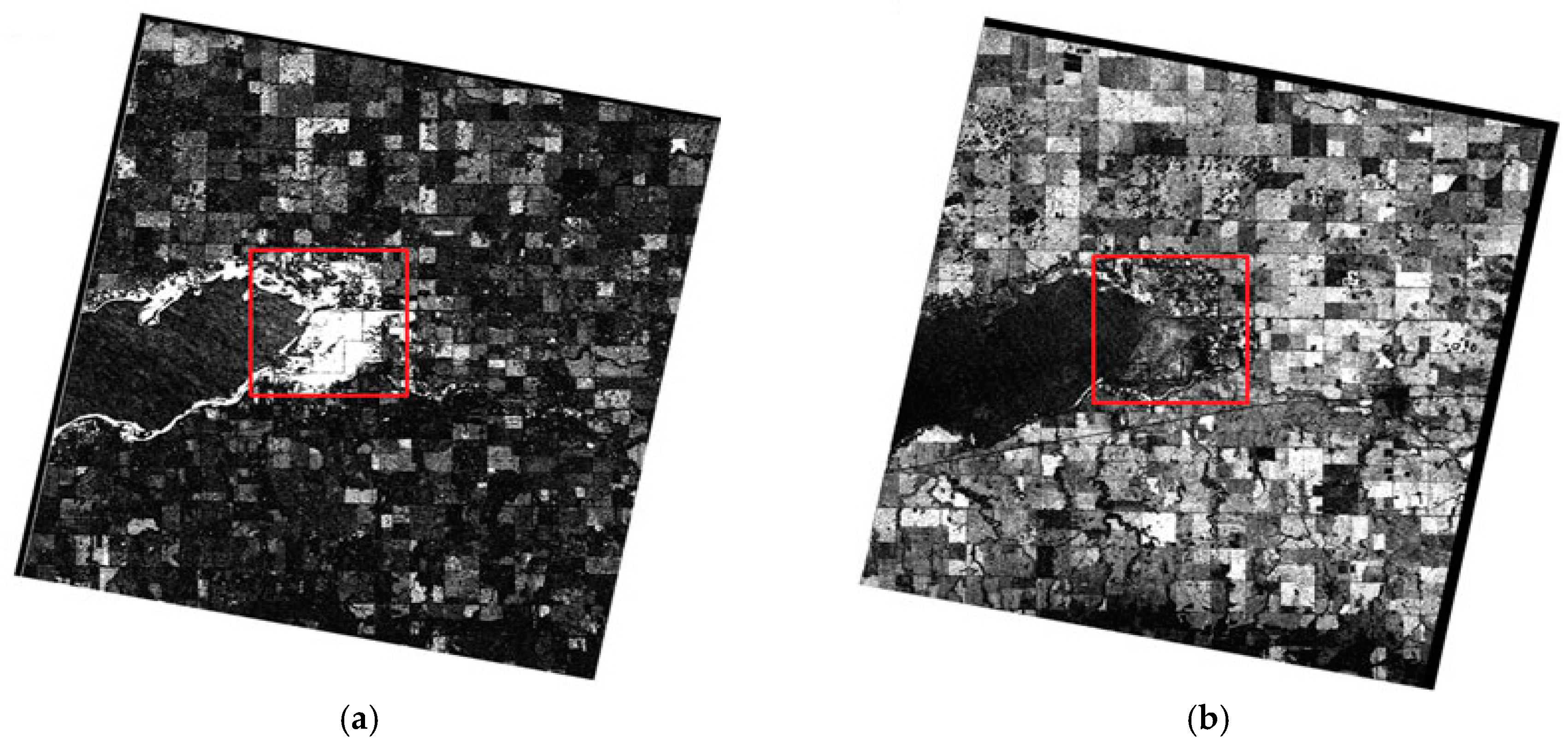
Canada’s wetlands are diverse and cover about 14 percent of the land area of Canada. Wetlands are an essential part of the environment and can take the form of marshes, bogs, fens, swamps and open water. Spaceborne remote sensing is an essential tool for the continuous monitoring of wetlands. The RCM, with its rapid revisit time, is expected to play an important role in monitoring wetlands within Canada, allowing the detection and tracking of changes in wetlands and the identification of possible impacts of these changes on species of plants, animals, and insects. The potential of the RCM for wetland monitoring was evaluated in [6]. Simulated CP SAR data of the RCM MR16 mode were derived and evaluated for flagging changes within wetlands. Changes within wetland could be crop or flooded vegetation to open water or open water to wet soil. In [6], the promising performance of the RCM for detecting both interannual (Figure 2a) and seasonal (Figure 2b) changes within wetlands was indicated. Change detection results using simulated RCM data were found comparable to those obtained using full polarimetric RADARSAT-2 data.
3.3. Maritime Pollusion Monitoring
The RCM with its frequent revisit capability will make it possible to monitor oil spills more closely, offering enhanced potential to support oil spill control and cleaning. Near real-time SAR data will be provided to meet the requirements of the Canadian Integrated Satellite Tracking of Pollution (ISTOP) program for both effective oil and ship detection. The RCM LN mode is expected to be used for oil spill monitoring. However, other RCM modes, such as those of medium resolutions, are being evaluated for their potential to monitor oil spills.
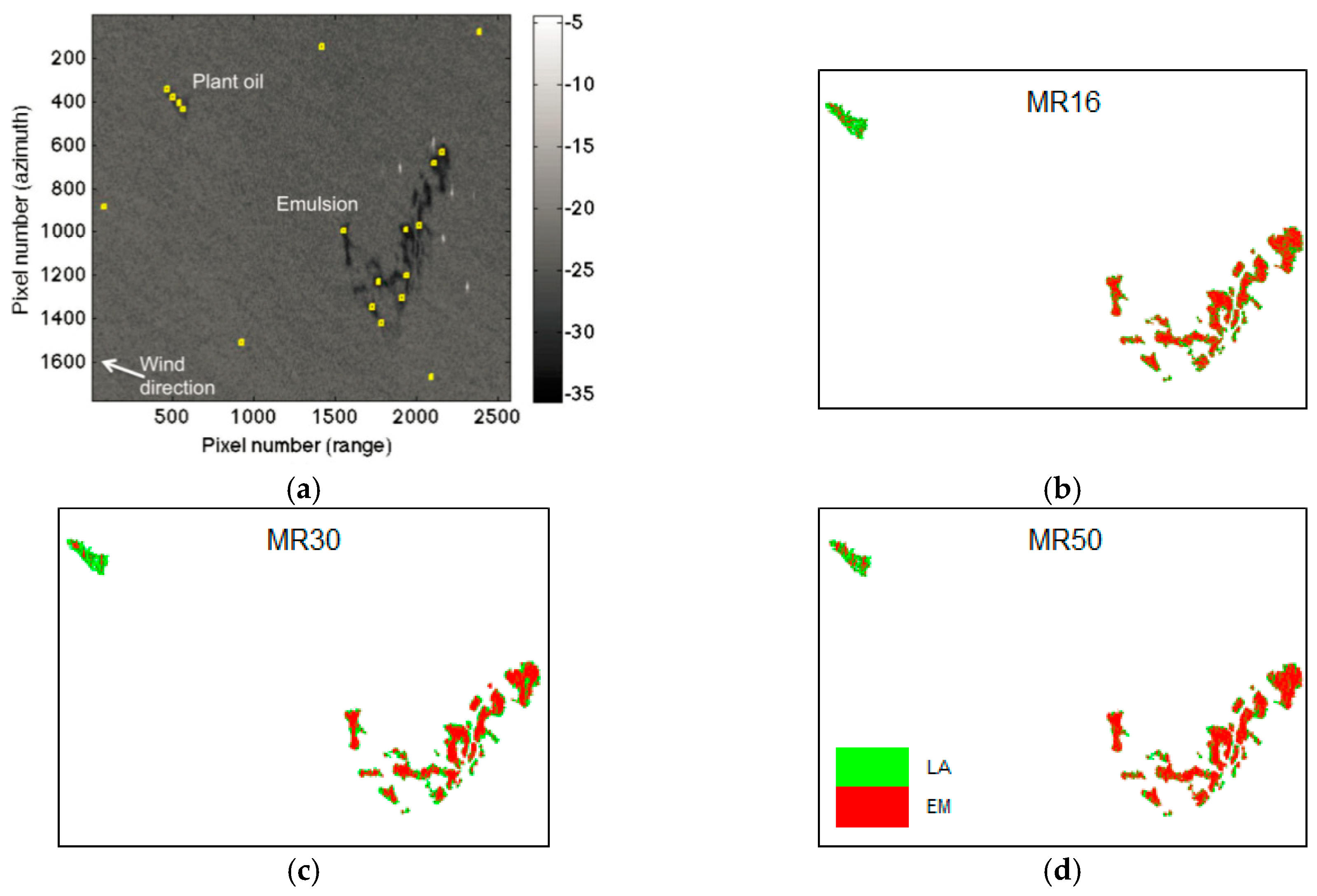
Example results of the performance of the medium resolution RCM SAR modes in the detection and classification of emulsion (EM), which is a mixture of oil and water, and plant oil, which was treated as lookalike (LA), are shown in Figure 3. The evaluation of the classification results indicated that the RCM MR 30 (Figure 3c) provided the highest overall classification accuracy (84.05%) for EM and LA in comparison to the RCM MR16 (Figure 3b) and MR50 (Figure 3d) modes (74.30% and 83.70%, respectively).
4. Conclusions
The RCM is the evolution of the RADARSAT Program and is expected to address many different applications within the public and private sectors, both in Canada and internationally. The increase in the revisit frequency of the mission introduces a range of applications which are based on regular collection of SAR imagery. Preliminary experimental results with simulated RCM CP data have shown the promising performance capability of the RCM in various environmental applications, including sea ice mapping, change detection in wetlands, and maritime pollution monitoring.
Author Contributions
Mohammed Dabboor conducted the experiments on the RCM potential for sea ice mapping, change detection in wetlands, and oil spill detection. All authors contributed to the writing of the paper.
Acknowledgments
RADARSAT-2 data and products © MacDonald, Dettwiler and Associates Ltd (Richmond, BC, Canada). (2013)—All Rights Reserved. RADARSAT is an official mark of the Canadian Space Agency.
Conflicts of Interest
The authors declare no conflict of interest.
Abbreviations
The following abbreviations are used in this manuscript:
| SAR | Synthetic Aperture Radar |
| RCM | RADARSAT Constellation Mission |
| ISTOP | Integrated Satellite Tracking of Pollution |
| EM | Emulsion |
| LA | Lookalike |
References
- Singhroy, V.; Charbonneau, F. RADARSAT: Science and applications. Phys. Can. 2014, 70, 212–217. [Google Scholar]
- Séguin, G.; Ahmed, S. RADARSAT constellation, project objectives and status. In Proceedings of the IEEE International Geoscience and Remote Sensing Symposium, Cape Town, South Africa, 12–17 July 2009; pp. II-894–II-897. [Google Scholar]
- De Lisle, D.; Iris, S.; Chalifoux, S. RADARSAT constellation mission serving Canadians. In Proceedings of the Spatial Knowledge and Information Canada Conference, Montreal, QC, Canada, 23–26 February 2017. [Google Scholar]
- De Lisle, D.; Iris, S. RADARSAT constellation mission status update. In Proceedings of the 11th European Conference on Synthetic Aperture Radar, Hamburg, Germany, 6–9 June 2016; pp. 1–3. [Google Scholar]
- Dabboor, M.; Geldsetzer, T. Towards sea ice classification using simulated RADARSAT constellation mission compact polarimetric SAR imagery. Remote Sens. Environ. 2014, 140, 189–195. [Google Scholar] [CrossRef]
- Dabboor, M.; White, L.; Brisco, B.; Charbonneau, F. Change detection with compact polarimetric SAR for monitoring wetlands. Can. J. Remote Sens. 2015, 41, 408–417. [Google Scholar] [CrossRef]
- Charbonneau, F.; Brian, B.; Raney, K.; McNairn, H.; Liu, C.; Vachon, P.; Shang, J.; De Abreu, R.; Champagne, C.; Merzouki, A.; et al. Compact polarimetry overview and applications assessment. Can. J. Remote Sens. 2010, 36, S298–S315. [Google Scholar] [CrossRef]
- Geldsetzer, T.; Arkett, M.; Zagon, T.; Charbonneau, F.; Yackel, J.; Scharien, R. All-season compact-polarimetry C-band SAR observations of sea ice. Can. J. Remote Sens. 2015, 41, 485–504. [Google Scholar] [CrossRef]
- Skrunes, S.; Brekke, C.; Eltoft, T. Characterization of marine surface slicks by RADARSAT-2 multipolarization features. IEEE Trans. Geosci. Remote Sens. 2013, 52, 5302–5319. [Google Scholar] [CrossRef]
Figure 1.
Classification of first year ice (FYI) and multiyear ice (MYI) in Victoria Strait in the Canadian Arctic using (a) simulated RADARSAT Constellation Mission (RCM) compact polarimetric (CP) data and (b) RADARSAT-2 full polarimetric Synthetic Aperture Radar (SAR) data.
Figure 1.
Classification of first year ice (FYI) and multiyear ice (MYI) in Victoria Strait in the Canadian Arctic using (a) simulated RADARSAT Constellation Mission (RCM) compact polarimetric (CP) data and (b) RADARSAT-2 full polarimetric Synthetic Aperture Radar (SAR) data.
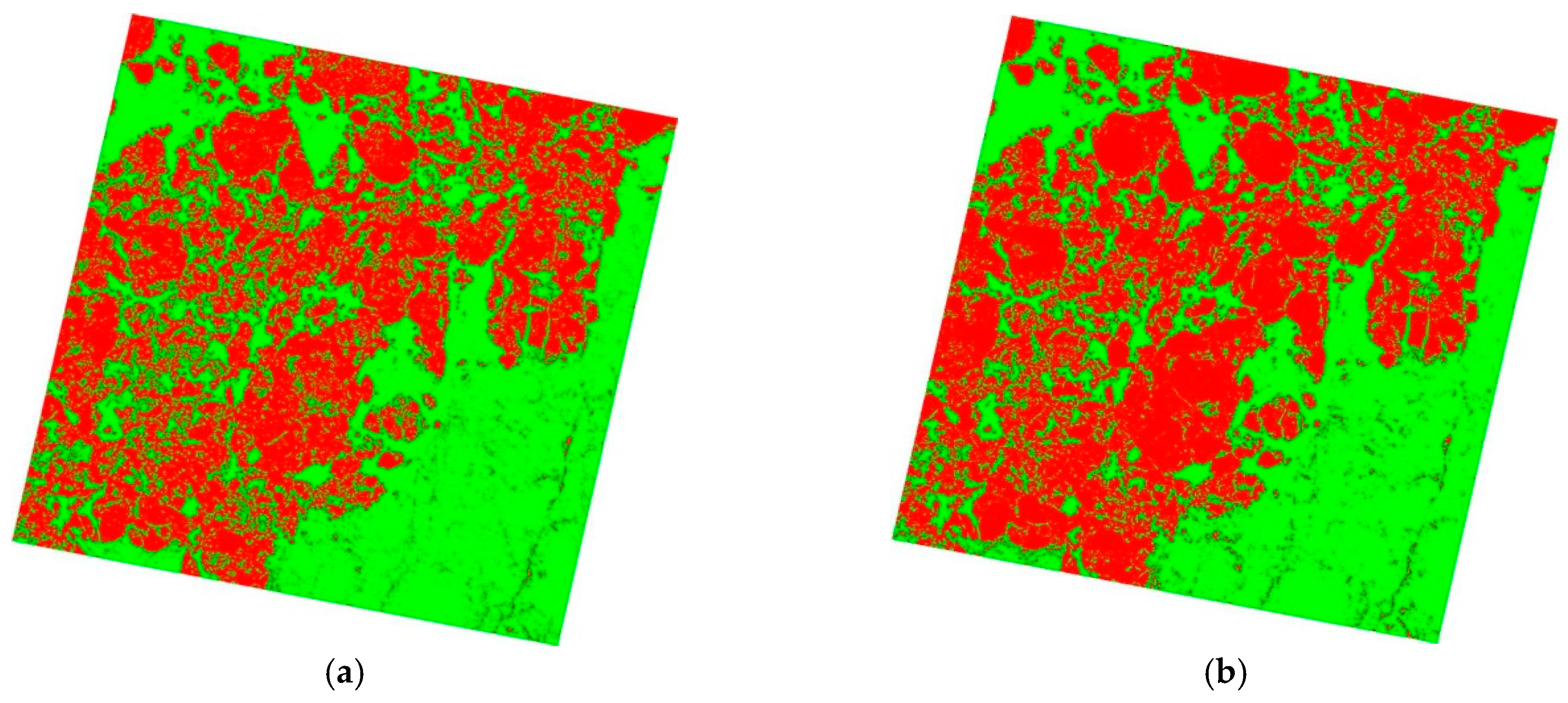
Figure 2.
Detected (a) interannual (May 2010 to July 2013) and (b) seasonal (May 2012 to September 2012) changes in Whitewater Lake, Manitoba. Red box indicates test site within the study area. Bright regions within the red box indicate regions with changes.
Figure 2.
Detected (a) interannual (May 2010 to July 2013) and (b) seasonal (May 2012 to September 2012) changes in Whitewater Lake, Manitoba. Red box indicates test site within the study area. Bright regions within the red box indicate regions with changes.

Figure 3.
(a) RADARSAT-2 VV SAR image with spilled plant oil (to be treated as lookalike) and emulsion [9]. Classification of emulsion and lookalike using simulated CP SAR data from the RCM (b) MR16, (c) MR30, and (d) MR50 modes.
Figure 3.
(a) RADARSAT-2 VV SAR image with spilled plant oil (to be treated as lookalike) and emulsion [9]. Classification of emulsion and lookalike using simulated CP SAR data from the RCM (b) MR16, (c) MR30, and (d) MR50 modes.

Table 1.
Characteristics of RCM SAR modes.
| Beam Mode | Nom. Res. (m) | Swath (km) | Looks (rng × az) | NESZ (dB) |
|---|---|---|---|---|
| Low Resolution (LR) | 100 | 500 | 8 × 1 | −22 |
| Medium Resolution 50 m (MR50) | 50 | 350 | 4 × 1 | −22 |
| Medium Resolution 16 m (MR16) | 16 | 30 | 1 × 4 | −25 |
| Medium Resolution 30 m (MR30) | 30 | 125 | 2 × 2 | −24 |
| High Resolution (HR) | 5 | 30 | 1 × 1 | −19 |
| Very High Resolution (VHR) | 3 | 20 | 1 × 1 | −17 |
| Ice/Oil Low Noise (LN) | 100 | 350 | 4 × 2 | −25 |
| Ship Detection | var. | 350 | var. | var. |
| Quad-Polarization | 9 | 20 | 1 × 1 | −25 |
Publisher’s Note: MDPI stays neutral with regard to jurisdictional claims in published maps and institutional affiliations. |
© 2018 by the authors. Licensee MDPI, Basel, Switzerland. This article is an open access article distributed under the terms and conditions of the Creative Commons Attribution (CC BY) license (https://creativecommons.org/licenses/by/4.0/).
Share and Cite
MDPI and ACS Style
Dabboor, M.; Iris, S.; Singhroy, V. The RADARSAT Constellation Mission in Support of Environmental Applications. Proceedings 2018, 2, 323. https://doi.org/10.3390/ecrs-2-05136
AMA Style
Dabboor M, Iris S, Singhroy V. The RADARSAT Constellation Mission in Support of Environmental Applications. Proceedings. 2018; 2(7):323. https://doi.org/10.3390/ecrs-2-05136
Chicago/Turabian StyleDabboor, Mohammed, Steve Iris, and Vern Singhroy. 2018. "The RADARSAT Constellation Mission in Support of Environmental Applications" Proceedings 2, no. 7: 323. https://doi.org/10.3390/ecrs-2-05136