Designing Affordable Technologies to Integrate Citizens in Early Warning Activities †


Interactive Systems Group-DEILAB, Computer Science Department, Universidad Carlos III de Madrid, 28911 Leganés, Madrid, Spain
*
Author to whom correspondence should be addressed.
†
Presented at the 12th International Conference on Ubiquitous Computing and Ambient Intelligence (UCAmI 2018), Punta Cana, Dominican Republic, 4–7 December 2018.
Proceedings 2018, 2(19), 1253; https://doi.org/10.3390/proceedings2191253
Published: 19 October 2018
(This article belongs to the Proceedings of UCAmI 2018)
Abstract
:Early warning consists of monitoring precursors of a potential hazard to understand if it is evolving to a real risk and then be able to orchestrate an early response before the event happens in order to reduce its impact and damages. It mainly consists on collecting updated and reliable data that can help emergency operators to understand how a situation is evolving and project its consequences, that is, to support situation awareness on a potential risk. This process could be improved by integrating volunteers and citizens into the data collection process given that they are intelligent sensors equipped with mobile devices that can be used almost everywhere to collect and share information. In this paper we introduce a system relying upon ubiquitous computing to integrate citizens in checking the evolution of potential hazards. An asynchronous focus group technique to assess the system with EM professionals is also described in the paper.
1. Introduction
Crisis are evolving processes that affect human beings and societies during a period of time [1]. Each crisis or disaster is a new process to deal with where existing knowledge, abilities and resources can be used but there are always unpredictable events that force to adapt any predefined plan [2,3]. Humans affected by the crisis or involved in its management would need to share information to get a whole picture of the situation and to coproduce knowledge about a changing and unstable situation. Information and communication technologies (ICT) can improve communication, coordination and collaboration in some tasks involved in the four phases of the EM process, mitigation, preparedness, response, and recovery [4]. Indeed, the popularity of the combination of social computing technologies and smartphones has raised many expectations about the active participation of citizens in EM [5]. Real life disasters demonstrate that citizens are usually the first-first responders in any catastrophic situation affecting their community since they are there [6] and also that they tend to rely upon the social structures, the resources and the authority relationships they are used to in their daily lives [7]. Therefore, their integration in the EM process should be considered as a necessity rather than a burden in order to mobilize the community social capital as a valuable resource to “reduce the vulnerability to hazards and cope with disasters” [8].
Many works of crisis informatics, that is the use of ICT to deal with crisis and disasters, have focused on probably the most obvious phase of the EM process: the response to a specific hazard [5]. However, the story starts before nothing has happened, when communities need to identify the potential hazards they are exposed to and get ready to react as efficiently as possible, that is, in the preparedness and mitigation phases. In this work we focus on the mitigation phase that is in charge of deciding how to act when a risk has been identified in order to minimize its potential impact [4] and, in particular, in the early warning stage. Early warning consists of monitoring precursors of a potential hazard to analyze if it is evolving to real risk and then be able to orchestrate an early response before the event happens in order to reduce its impact and damages [9]. For instance, precursors of a potential wildfire that need to be monitored are weather and vegetation dryness. In addition to checking how these precursors evolve, the potential area can also be checked to identify other issues that might complicate the response, like existence of fuels in the area and uncontrolled human activities (like spontaneous gatherings or settlements) [10]. In this work we explore how to engage volunteers and citizens in this phase of the EM process assuming that such warning tracking process might be improved by integrating citizen generated information [11,12] in a similar way as citizen science does. Since the expected participants might not have any egotist or intrinsic motivation to participate, as nothing has happened yet, not even alarms or alerts have been issued, this proposal makes use of a gamified approach to encourage participation.
2. Early Warning Systems
After the devastating effects of 2004 Indian Ocean tsunamis [9] the focus of EM moved to early warning activities with a view to decrease the impact of natural or man-made hazards. Early warning can reduce the damages by collecting updated and reliable information before the hazard happens, so an early response can be orchestrated. Early warning systems are often implemented as iterative cycles made up of four activities; collecting data and monitoring precursors, analyzing data to identify hazards, communicating hazards and starting early response activities [9]. Early warning ICT-based systems that make use of sensors and radar based information already exist, particularly for fire early warning [10]. What we propose in this work is to integrate citizens in this process as claimed in [9,13], not only to provide a better service to the community but also to build more resilient communities, aware of the risks they might be exposed to and with capacity to recover effectively from disasters [14].
Citizens are intelligent sensors scattered through the potentially affected areas and who are equipped with mobile devices that can be used to capture and send updated information to the EM center [11]. The integration of official and non-official information sources, the later usually called back-channel communication, can support better situation awareness to human decision makers. Situation awareness is the perception of relevant data in the environment within a time and concerning a physical space, the comprehension of their meaning and the projection of the evolution of the status of a situation based on such comprehension of data [15]. Citizens can contribute by providing updated data on the precursors of a specific hazard (for instance how dryness is affecting an area) that should then be provided in a manageable and understandable way to decision makers. At this point a key issue to consider is that citizens are not a homogeneous crowd of people sharing exactly the same capabilities to capture and, particularly, to identify and process relevant information. In [12] the integration of official volunteer groups in early warning activities is already discussed. Prepared volunteers provide reliable information since they have specific skills to assess the quality of the data and their relevance. However, less reliable and non-curated information sources like citizen-generated content can also be useful as far as they can be properly managed. Thus, citizen-generated data have to be aggregated, filtered and reorganized to generate knowledge about a situation in order to enable situation awareness instead of overloading decision makers with unnecessary, repeated or unrelated data.
Ubiquitous computing technologies provide the means to collect different types data about potential hazards and their evolution, using both artificial and human sensors, but to the best of our knowledge there is no systems taking profit of this potential to support early warning activities though similar approaches are used for the response phase, like the WeSenseIt platform that combines human and artificial sensors for flood management [16]. In the next section we describe the iWarn system that has been envisioned as an affordable technology to move to a participatory early warning process integrating both volunteers and citizens in the tracking of precursors.
3. iWarn: A Digital Knowledge Ecosystem for Early Warning Activities
Planning activities for early warning can help EM agencies in enhancing the efficiency and the effectiveness of the response phase. The early warning activities aim at preparing operators, volunteers and citizens to be ready when an emergency occurs. In particular, the participation of citizens and volunteers is crucial to help the operators in collecting information about a specific situation by continuously checking the evolution the hazard precursors. In the EM operation center, this information can be used to be understand how the hazard is evolving and determine whether an alert or warning to the population has to be issued.
In this context, we have designed a Digital Knowledge Ecosystem (DKE) for supporting professionals, volunteers and citizens in monitoring alerts about potential risks in a specific geographical area that is called iWarn. iWarn is being envisioned along with the Spanish General Directorate of Civil Protection and Emergencies that was interested in providing a ICT platform for radio amateurs who already participate in early warning activities but using the radio. The initial goal was to incorporate the benefits of ubiquitous computing to support more communication channels. Additionally, it was decided to open the participation to citizens who might be interested in their community and environment, so that the DKE can be also used to analyze how citizens can be mobilized in this kind of processes and how systems have to be designed to make this participation useful for the EM services as discussed in [13]. In [17] we already identified the requirements such DKE should satisfy and outlined its potential interfaces and features that are summarized in Table 1. In this paper we describe the fully operational DKE implemented and we discuss how it can be evaluated.
The iWarn DKE has two main components (see the architecture in Figure 1): the operation central system and the mobile application. Next subsections describe each of these two components.
3.1. The iWarn Central System
The central system is a map-based web page used by the emergency operators for managing information related to early warnings [17], both official information collected through sensors or other official information providers as well as citizen-generated content. Let’s consider the following scenario. The Spanish Civil Protection has received from the national meteorological agency, a high temperature alert in the province of Santa Cruz de Tenerife in the archipelago of the Canary Islands, an area where wildfires are frequent and that is also overcrowded with tourists. As part of the action plan, it has been decided to ask the population to look for pictures reporting any dangerous situation they witness in the area, such as waste on the ground, illegal campfires and barbeques, cigarette butts, etc. To promote the participation, the citizens are involved in a sort of game: every time they take a picture that the Civil Protection considers useful, they receive 15 points as reward.
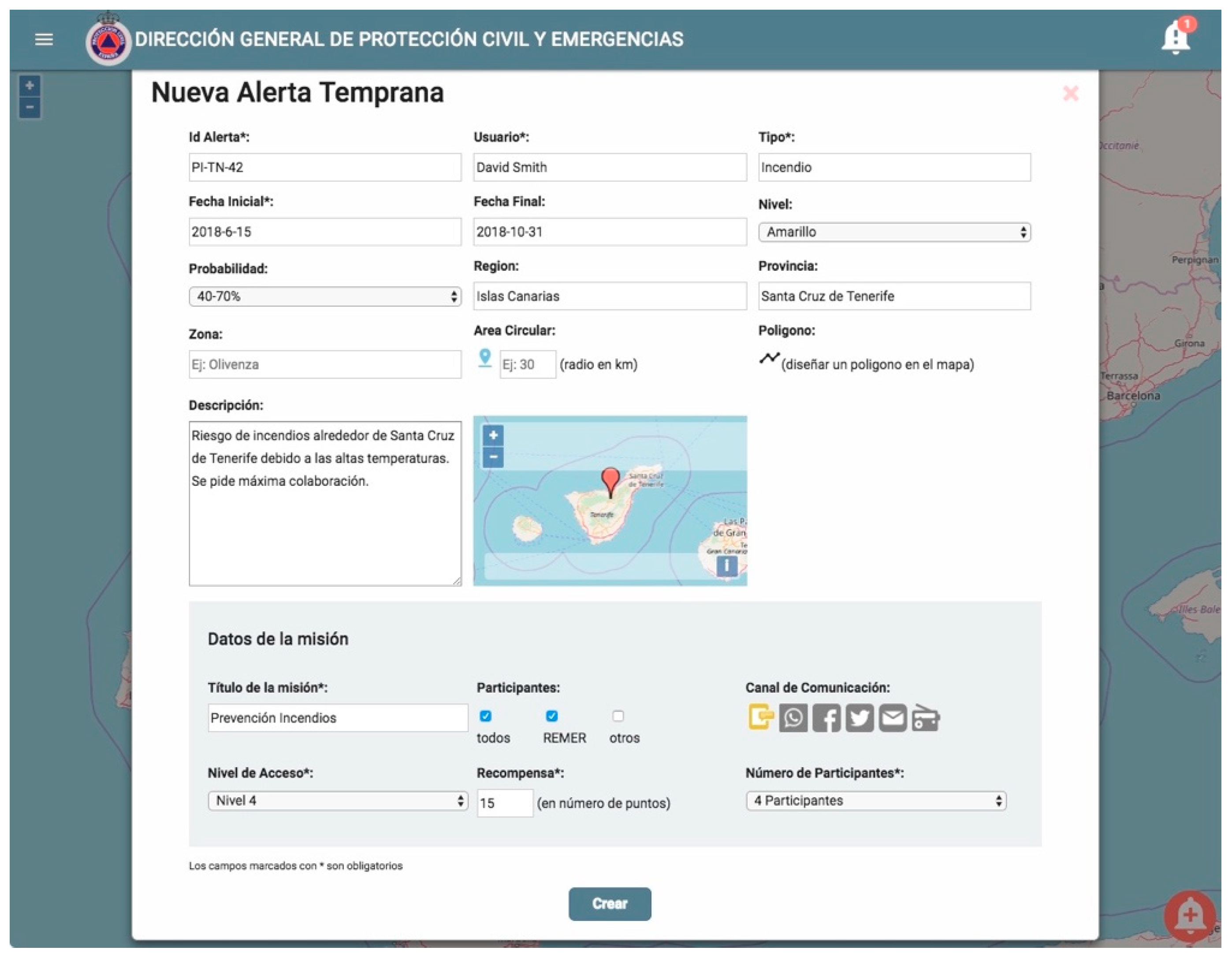
When there are precursors about a potential hazard, such as the expected high temperatures in the scenario, EM operators can create an Early Warning affecting a geographic area so that they can involve people in a checking process to get updated information on the status of the potentially affected area. Early Warnings are placed on the map as circles or polygons that EM operators can interact with to provide more information or to analyze the information collected by the participants in the tracking process of the hazard precursors. When creating the Early Warning, the EM operator can provide additional information about it, like the kind of hazard or its expected probability as shown in Figure 2. The interface of iWarn is in Spanish since it is the mother tongue of its expected users. Operators can also decide which kind of participants should be notified, distinguishing between official volunteers or citizens registered in the system and dwelling in the affected area. The way to send the early warning notification can also be selected to support multiple and redundant ways of communication, including text messages, notifications through the iWarn app, social networks and radio messages. Since the iWarn app is designed as a gamified environment (see next subsection), the operator can also determine issues concerning the game mechanics such as the award that will be received by participants when successfully completing the information gathering mission or the level required to participate in the mission.
Operators can also receive notifications for which the bell icon in the right corner of the interface is used. Notifications can come from external sources, like for example meteorological or traffic agencies, or from participants and visualize them on the map.
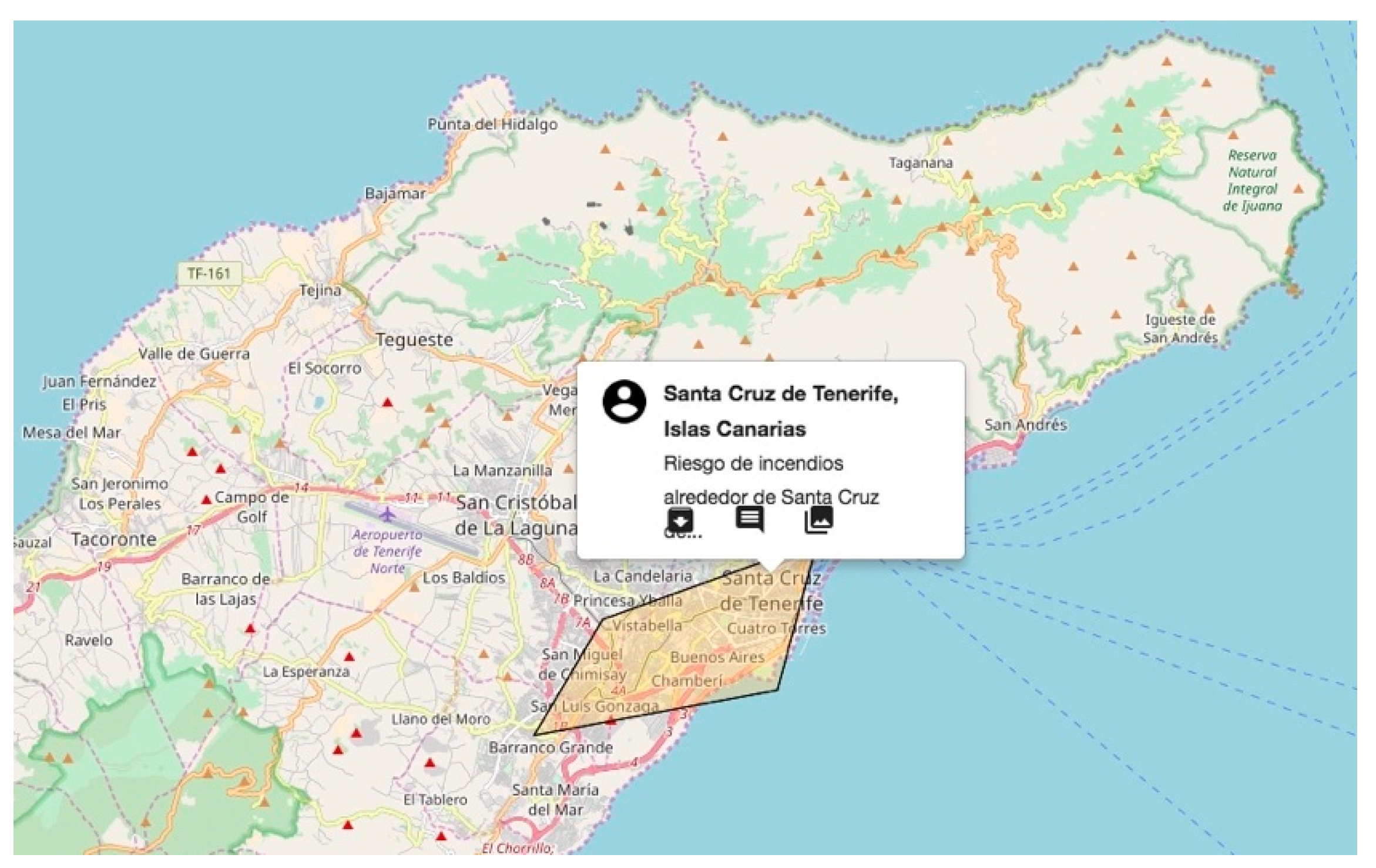
Once the Early Warning is created, operators can open it to see its description and all the information received from the participants (see Figure 3).
3.2. The iWarn Mobile Application
The mobile component of the DKE is a web application designed for receiving notifications about early warnings and promoting the participation of volunteers and citizens. Web technologies are an affordable way to have a responsive design that can be easily adapted to a great variety of devices, as smartphones, tablets or laptops.
To encourage citizens in collecting potentially useful data for the emergency operation center we have developed a gamified app. Compared to the response phase, in early warning there is no personal perception of danger since nothing has happened yet, so citizen engagement has to be encouraged. Gamification consists of using principles of game design to improve user engagement with certain features [18]. In this work, we apply this technique modeling the warning notifications as a set of activities, called missions, to perform that include typical game features like earning points, getting levels of expertise of cooperating with other in the mission. More information on the gamified version can be obtained at [19]. These activities have a double aim: collecting useful information for the operation center and offer an enjoyable experience for the users.
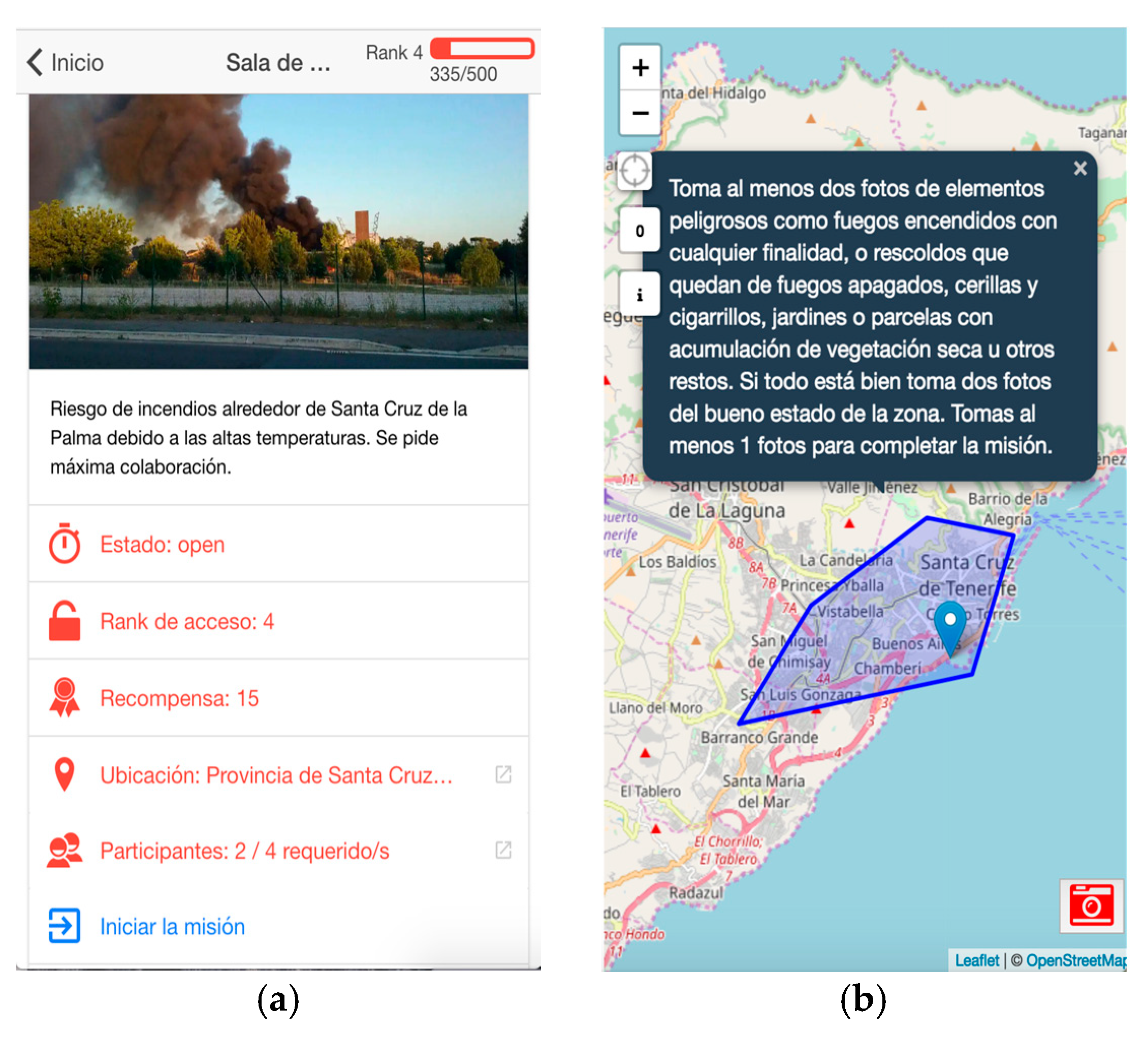
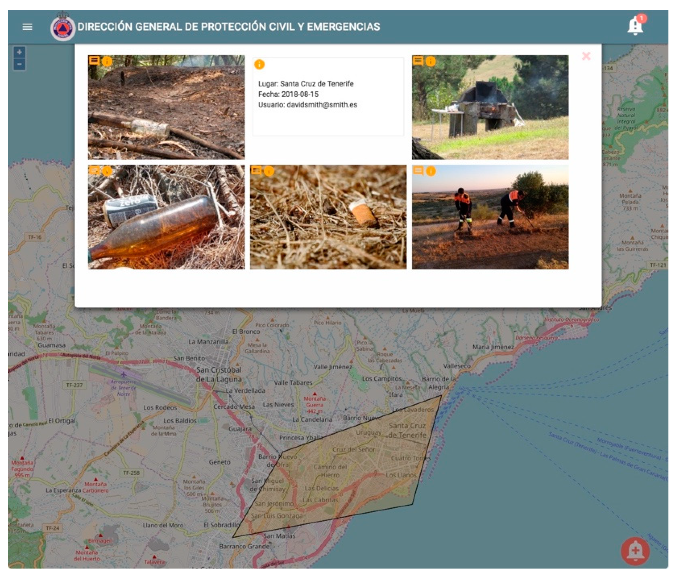
Following with our scenario, operators have sent an early warning using the iWarn Central System. Citizens who use the iWarn app and are in the area (residents and tourists) have received a notification to participate actively in a prevention mission, and several of them have decided to participate. In the mission, participants are encouraged to take at least two pictures of fires lit for any purpose, embers left over from fires turned off, gardens or parcels with an accumulation of dry vegetation or other remains and other risky elements around the markers in the map When the user receives the notification, she can access the mission board (see Figure 4a) to check its details like the status (i.e., open, close or archived), the required experience, the reward that can be obtained, the location, and the number of current participants. There is a button to confirm participation in the mission. Once accepted, the mission consists of a map card with the affected area marked by a circle or a polygon and some instructions about how to collect information (see Figure 4b). Participants use the camera to take pictures that are immediately shown in the central system interface (see Figure 5). If their contributions are rated as useful by the EM operators, participants can win points that increase their expertise level used to participate in more complex and interesting missions.
Figure 5 shows a collection of pictures that could be received by the central system from the mobile applications. Each one of them has a i button to retrieve information about the image (i.e., location, date and author as shown in the second box of the first line in Figure 5), and an action icon to send a message to the author.
4. Evaluating the iWarn: Asynchronous Focus Group with Emergency Practitioners
The proposed DKE aims at supporting EM operators in early warning by integrating citizens in monitoring activities. To understand whether iWarn, which is based on a previous experience with volunteers [12], can be an acceptable and affordable for users an evaluation is required. The first step of such evaluation consists of understanding whether this approach is valid for decision makers at EM centers. Assessing the gamified app with potential users will not have any impact if professional decision makers do not accept it as a valid resource to collect relevant information. Indeed, gamification can encourage participation but can also overstimulate participants and produce useless or unmanageable data. With this purpose the first evaluation is focused on EM workers and it is aimed at understanding which is the right balance between citizen participation and efficient information management at the operation center.
In particular, we will involve EM practitioners in a focus group to discuss about different aspects related to the utility of the iWarn system and its potential usage in a real scenario. The participation of EM workers in evaluation procedures is quite costly and complicated due to their availability. A crisis situation can happen anytime, and they have to be ready to react so they do have few time to devote to this kind of technology evaluations. Moreover, having a varied perspective of different agencies can enrich the findings since the manageability of information depends very much on the available resources to process it [13]. For this reason, we decided to run an asynchronous focus group technique in which participants are not forced to be present at the same time or place, but they can contribute to the discussion using online platforms.
An asynchronous focus group, also known as bulletin board focus group, invites several people to participate at a computer mediated discussion to discuss a set of questions or topics during a fixed period of days or weeks [20]. The advantage of this kind of meeting is that the participants can contribute at their own pace since they do not depend on the availability of the others.
In our case, to achieve the main objective of the evaluation (i.e., to assess the potential utility of iWarn for EM workers) we are recording videos showing how the DKE works in a real scenario, the one previously described. The videos about the DKE are uploaded on a blog where a group of operators and volunteers with several years of experience in emergency situations can watch them and participate on an online discussion about the potential utility and limitations of the proposed service. To collect interesting results, it is crucial to promote the brainstorming and the discussion of topics. With this purpose, each functionality of the system includes a video a set of questions and claims about the utility of the described functionality. Participants are invited to discuss the claims proposed or create new ones on their position about the utility, limitations or potential improvements of such functionality. At the end of this process, we will have a bulletin board with opinions and suggestions posted by the participants that can be analyzed to understand how iWarn could support them in integrating citizens in the early warning process.
5. Conclusions and Future Works
Empowering citizens in early warning activities might contribute to provide a better service but also to make citizens more aware of their environment and the potential risks they might be affected by. In this context, ubiquitous computing could contribute to support more resilient communities by empowering citizens to take part in the process. For that to be possible, EM workers and decision makers have to perceive such participation as a contribution not as a burden.
In this paper we discussed how to integrate citizen generated information to monitor precursors of potential hazards in order to get a better picture of the situation by taking profit of ubiquitous computing and human sensors. We also introduced the current implementation of a multi-device system called iWarn that aims at supporting citizens in sending information and operators in processing and making sense out of it. We also designed a potential way to evaluate the utility of the approach by professional EM workers before testing the app with citizens.
The next steps will include carrying out the evaluations and improving the system to be sure that it complies with the EM necessities, protocols and expectations. Once the system has been tested by EM workers, evaluations of the iWarn app will make it possible to assess if gamification encourages or distorts participation.
Author Contributions
P.D. leads the project, defined the DKE architecture and the focus group design. T.O. has designed the central system for EM workers and Marco Romano has designed the gamified app. I.A. helps with the design of the focus group. All authors have read and agreed to the published version of the manuscript.
Funding
This work is supported by the project PACE grant funded by the Spanish Ministry of Economy and Competitiveness (TIN2016-77690-R).
Conflicts of Interest
The authors declare no conflict of interest.
References
- Oliver-Smith, A.; Hoffman, S.M. Theorizing Disasters: Nature, Power and Culture. In Catastrophe and Culture: The Anthropology of Disaster; Oliver-Smith, A., Ed.; School of American Research Press: Santa Fe, MN, USA, 2002. [Google Scholar]
- Turoff, M.; Chumer, M.; Van de Walle, B.; Yao, X. The Design of a Dynamic Emergency Response Management Information System (Dermis). J. Inf. Technol. Theory Appl. (JITTA) 2004, 5, 1–36. [Google Scholar]
- Waugh, W.L.; Streib, G. Collaboration and leadership for effective emergency management. Public Adm. Rev. 2006, 66, 131–140. [Google Scholar] [CrossRef]
- Petak, W.J. Emergency management: A challenge for public administration. Publ. Adm. Rev. 1985, 45, 3–7. [Google Scholar] [CrossRef]
- Palen, L.; Anderson, K.M.; Mark, G.; Martin, J.; Sicker, D.; Palmer, M.; Grunwald, D. A vision for technology-mediated support for public participation and assistance in mass emergencies and disasters. In Proceedings of the ACM-BCS ’10, British Computer Society, Swinton, UK, 14–16 April 2010; p. 12. [Google Scholar]
- Stallings, R.A.; Quarantelli, E.L. Emergent citizen groups and emergency management. Public Adm. Rev. 1985, 45, 93–100. [Google Scholar] [CrossRef]
- Dynes, R.R. Social Capital Dealing with Community Emergencies. Homel. Secur. Aff. 2006, 2, 1–26. [Google Scholar]
- FEMA. Principles of Emergency Management; FEMA: Washington, DC, USA, 2007. [Google Scholar]
- de León, J.C.V.; Bogardi, J.; Dannenmann, S.; Basher, R. Early warning systems in the context of disaster risk management. Entwickl. Ländl. Raum 2006, 2, 23–25. [Google Scholar]
- de Groot, W.J.; Goldammer, J.G.; Keenan, T.; Brady, M.A.; Lynham, T.J.; Justice, C.O.; O’Loughlin, K. Developing a global early warning system for wildland fire. For. Ecol. Manag. 2006, 234, S10. [Google Scholar] [CrossRef]
- Goodchild, M.F. Citizens as sensors: The world of volunteered geography. GeoJournal 2007, 69, 211–221. [Google Scholar] [CrossRef]
- Herranz, S.; Romero-Gómez, R.; Díaz, P.; Onorati, T. Multi-view visualizations for emergency communities of volunteers. J. Vis. Lang. Comput. 2014, 25, 981–994. [Google Scholar] [CrossRef]
- Díaz, P.; Carroll, J.M.; Aedo, I. Coproduction as an Approach to Technology-Mediated Citizen Participation in Emergency Management. Future Internet 2016, 8, 41. [Google Scholar] [CrossRef]
- Norris, F.H.; Stevens, S.P.; Pfefferbaum, B.; Wyche, K.F.; Pfefferbaum, R.L. Community resilience as a metaphor, theory, set of capacities, and strategy for disaster readiness. Am. J. Commun. Psychol. 2008, 41, 127–150. [Google Scholar] [CrossRef] [PubMed]
- Endsley, M.R. Designing for Situation Awareness: An Approach to User-Centered Design; CRC Press: Boca Raton, FL, USA, 2003. [Google Scholar]
- Wehn, U.; Rusca, M.; Evers, J.; Lanfranchi, V. Participation in flood risk management and the potential of citizen observatories: A governance analysis. Environ. Sci. Policy 2015, 48, 225–236. [Google Scholar] [CrossRef]
- Díaz, P.; Onorati, T.; Aedo, I. A digital knowledge ecosystem to increase participation in emergency warnings and alerts management. In Proceedings of the International Conference on Green, Pervasive, and Cloud Computing, Cetara, Italy, 11–14 May 2017; Springer: Cham, Switzerland, 2017; pp. 700–711. [Google Scholar]
- Hamari, J. Transforming homo economicus into homo ludens: A field experiment on gamification in a utilitarian peer-to-peer trading service. Electron. Commer. Res. Appl. 2013, 12, 236–245. [Google Scholar] [CrossRef]
- Romano, M.; Díaz, P.; Aedo, I. A gamified platform for civic engagement in early warning. Interacción 2018. [Google Scholar] [CrossRef]
- Krueger, R.A. Focus Groups: A Practical Guide for Applied Research; Sage Publications: Newcastle upon Tyne, UK, 2014. [Google Scholar]
Figure 1.
The architecture of the DKE for Early Warning: the central system receives information from external sources or from the operator and sends notifications to the mobile application; the mobile application receives notifications from the central system and allows citizens to send back photos, videos or textual information.

Figure 2.
The form for creating a new early warning (“Nueva alerta temprana” in the interface) includes the following fields: warning id (Id Alerta), username (Usuario), type (Tipo), start date (Fecha Inicial), end date (Fecha Final), level (Nivel), probability (Probabilidad), region (Region), province (Provincia), zone (Zona), circle area (Area Circular), polygon (Poligono), description (Descripción), title of the mission (Titulo de la misión), type of participants (Participantes), communication channel (Canal de Comunicación), experience required to participate (Nivel de Acceso), reward (Recompensa), number of participants (Número de Participantes).

Figure 3.
A detail of the DKE central system. The warning popup shows additional information about the early warning, including the author profile, the location, a short description, and three actions: from left to right, archive the warning, contact with the users participating in the mission, and show the content generated by participants.

Figure 4.
Two screens from the mobile application: (a) mission card with details such as the status, the required experience, the reward, the location and the number of participants; (b) map card shown once a mission is accepted by the user, with the instructions about what to do.
Figure 4.
Two screens from the mobile application: (a) mission card with details such as the status, the required experience, the reward, the location and the number of participants; (b) map card shown once a mission is accepted by the user, with the instructions about what to do.

Figure 5.
The gallery view in the central system with all the pictures sent from the mobile application about the fire warning.
Figure 5.
The gallery view in the central system with all the pictures sent from the mobile application about the fire warning.


Table 1.
Design requirements for a DKE on emergency early warning [17].
Table 1.
Design requirements for a DKE on emergency early warning [17].
| Multi-device platforms have to be implemented to support different tasks, performed in different contexts and by different users’ profiles. |
| Participants can have a different levels of reliability and trust, and these levels has to be made explicit in the information visualization so that decision makers can quickly identify relevant data |
| Warnings can be generated by the initiators or imported from external official sources, like the meteorological hazards institutes or the seismographic risks institutes. |
| The system has to be scalable, sustainable and adaptive. EM workers need to be able to personalize all the components of the DKE (such as agents involved, preferred sources of information, type of feedback required, type of visualization of data) to cope with unexpected and variable situations |
| Interfaces have to be intuitive, easy to understand and easy to interact with. The information and interaction capabilities offered should avoid information overload. They have to be easy to remember since many users will not use them on a daily basis |
| If mobile apps are developed to collect authenticated and curated data, their design should minimize the storage space required in the user device. If not, users might remove the app as soon as the early warning process ends |
| Social networks can provide interesting data as far as data are organized, filtered and visualized in a meaningful and interpretable way |
| Different communication channels have to be offered to encourage the citizen participation and to support different operation conditions in the network, including emails, sms, social network messages or radio transmissions. |
Publisher’s Note: MDPI stays neutral with regard to jurisdictional claims in published maps and institutional affiliations. |
© 2018 by the authors. Licensee MDPI, Basel, Switzerland. This article is an open access article distributed under the terms and conditions of the Creative Commons Attribution (CC BY) license (https://creativecommons.org/licenses/by/4.0/).
Share and Cite
MDPI and ACS Style
Díaz, P.; Onorati, T.; Romano, M.; Aedo, I. Designing Affordable Technologies to Integrate Citizens in Early Warning Activities. Proceedings 2018, 2, 1253. https://doi.org/10.3390/proceedings2191253
AMA Style
Díaz P, Onorati T, Romano M, Aedo I. Designing Affordable Technologies to Integrate Citizens in Early Warning Activities. Proceedings. 2018; 2(19):1253. https://doi.org/10.3390/proceedings2191253
Chicago/Turabian StyleDíaz, Paloma, Teresa Onorati, Marco Romano, and Ignacio Aedo. 2018. "Designing Affordable Technologies to Integrate Citizens in Early Warning Activities" Proceedings 2, no. 19: 1253. https://doi.org/10.3390/proceedings2191253