Proceeding Paper

Numerical Modelling of Soil Erosion on Cephalonia Island, Greece Using Geographical Information Systems and the Revised Universal Soil Loss Equation (RUSLE) †

Management Body of Mt. Aenos National Park, Koutavos Environmental Center, 28100 Argostoli, Cephalonia Island, Greece
*
Author to whom correspondence should be addressed.
Presented at the 3rd EWaS International Conference on “Insights on the Water-Energy-Food Nexus”, Lefkada Island, Greece, 27–30 June 2018.
Proceedings 2018, 2(11), 618; https://doi.org/10.3390/proceedings2110618
Published: 31 July 2018
(This article belongs to the Proceedings of EWaS3 2018)

Abstract

:
Soil erosion on Cephalonia Island, Greece has been identified as a predominating land degradation process and a major threat to the sustainability of the agricultural sector. In the present work, the evolution of soil erosion on the island was estimated for the years 2000 and 2012. A simple empirical model, the Revised Universal Soil Loss Equation (RUSLE) for modeling soil erosion, was applied in a Geographical Information System (GIS). The results indicate that the mean annual soil erosion was estimated to be 12.78 t/ha for the year 2000 and 12.28 t/ha for the year 2012. Further, 38.24% of the area of Cephalonia demonstrated moderate to significantly high soil erosion in the year 2012 compared to 40.55% in year 2000. We can assume that during the period 2000–2012, despite influences on the natural environment including forest fires and overgrazing, the combination of vegetation and other protective soil factors contributed to reducing soil erosion.

1. Introduction

Soil erosion is triggered by a combination of natural and anthropogenic factors including steep slopes, intense rainfall, sparse vegetation, and inappropriate land use [1]. Extensive soil erosion leads to the irreversible loss of forest and agricultural land and related ecosystem services. Soil erosion reduces the productivity of agricultural land, imposing restrictions on their sustainable use. The effect of soil erosion that is causing most concern is the loss of the surface layer, which is the most fertile part of the soil profile [2].
According to the GLobal Assessment of SOil Degradation (GLASOD), it is estimated that 114 million hectares are affected by anthropogenic soil erosion. The main causes of soil erosion in the European Union are unsustainable agricultural practices, fires, overgrazing, deforestation, and infrastructure building [3]. The Mediterranean region is particularly sensitive to soil erosion [4]. High rates of soil erosion combined with slow soil formation have led to an irreversible decline in the quality and quantity of Mediterranean soils [5].
The island of Cephalonia, as with many Mediterranean islands, is subject to several factors that have exacerbated the phenomenon of soil erosion. Such factors include forest fires, agricultural land fragmentation and abandonment, unsuitable land for agricultural use, the use of unsustainable agricultural practices, overgrazing, drought, and limited water resources. As a consequence of the above interacting factors, soil erosion in the island has been identified as a major land degradation process.
Today, a large set of empirical, semi-empirical, and physical process models for soil erosion assessment are available [6]. The most widely applied empirical model for assessing soil erosion by water runoff is the Universal Soil Loss Equation (USLE) developed by [7]. The USLE equation and the revised form, Revised Universal Soil Loss Equation (RUSLE) [8], have been applied experimentally for more than 40 years in the USA by the US Agricultural Research Agency (USDA) [9]. The RUSLE equation was used in this study.
The dynamic relationship between human activities and soil erosion requires monitoring of the phenomenon. Regular monitoring allows competent authorities to assess the influence of policy decisions and land-use changes on soil erosion. The present study aims to provide quantitative estimates of soil erosion for the island of Cephalonia for the period 2000–2012. In this context, areas with a high risk of soil erosion are mapped.

2. Materials and Methods

The RUSLE soil loss equation was implemented with the support of Geographic Information Systems. The relevant input parameters of the model were calculated separately and stored as vector data. Five vector data items, each of the five factors of the RUSLE model, were converted to raster images with a 20-m pixel resolution. In each pixel, a value was assigned equivalent to the value of the corresponding model parameter. Each raster layer was then combined for calculating the soil loss rate for each pixel of the study area for the years 2000 and 2012.
The RUSLE soil loss equation is expressed as a simple product of the different factors as indicated in the following equation:
A = R × K × LS × C × P,
where:
  • A, soil loss per unit area (t/ha),
  • R, rainfall erosivity factor (MJ mm/ha h),
  • Κ, soil erodibility factor (t h M/J mm),
  • LS, topographic factor that constitute of the slope length factor (L) and slope steepness factor (S) (-),
  • C, vegetation management factor (-), and
  • Ρ, erosion control practice factor (-).
The numerical values of the six factors in the first version of the equation were derived from data processed from small river basins in the USA. This of course is a weakness of the equation when it is implemented in areas outside the USA. The RUSLE equation does not appreciate the transport of sediments on the streams of a basin and does not produce acceptable estimates of soil loss in large basins [6]. Another significant disadvantage of the equation is that it evaluates soil erosion by multiplying completely different factors representing rainfall erosivity, soil erodibility, topographical factors, vegetation management cover factors, and erosion control practices; in fact, it is true that soil erosion cannot be estimated in such a simplistic manner [10]. Apart from these drawbacks, the implementation of this equation produces satisfactory results as an initial approximation of estimating soil loss. The RUSLE equation was applied with an acceptable outcome for the determination of soil erosion at the Kremasta Reservoir in Western Greece [11], in Cephalonia Island [6], and many other areas of Greece.
It is clear that the advantages of the RUSLE equation include the simple procedure for collecting the appropriate data [6]. The data necessary for calculating soil loss is a Digital Elevation Model for the production of the LS topographic factor, the mean annual rainfall for the calculation of the rainfall erosivity factor R, a geological or soil map for the determination of the soil erodibility K factor, and a land-cover map for the calculation of the vegetation management cover C factor and the Erosion control practice factor P.

3. Results

3.1. Rainfall Erosivity Factor (R)

The estimation of the rainfall erosivity factor (R) is the most important factor for the correct and effective implementation of the soil loss equation. The value of the factor is the sum of the EI30 factor for all the storms during a hydrological year where E is the kinetic energy of the rainfall and I30 is the maximum 30-min rainfall intensity in each rainfall [6,12]. However, because such data are not available because of the lack of the necessary data (only one meteorological station of the National Meteorological Service (NMH) with historical data across the island), simple linear regression ratios that estimate the R factor in relation to the average annual value of rainfall were determined. There is no link in the literature linking the R factor to the average annual rainfall for the Greek conditions. For this reason, an equation valid in Italy [13] was used:
R = α × Pj,
where Pj (mm) is the mean annual rainfall and α = 1.3.
The numerical value of the factor α derives from a simple linear regression between the R factor and the mean annual rainfall. The average annual rainfall, based on the NMH data for the Argostoli rainfall station, was estimated to be 799.8 mm. Therefore, the rainfall erosivity factor for the island of Cephalonia was estimated to be 1039.74 MJ mm/ha h.

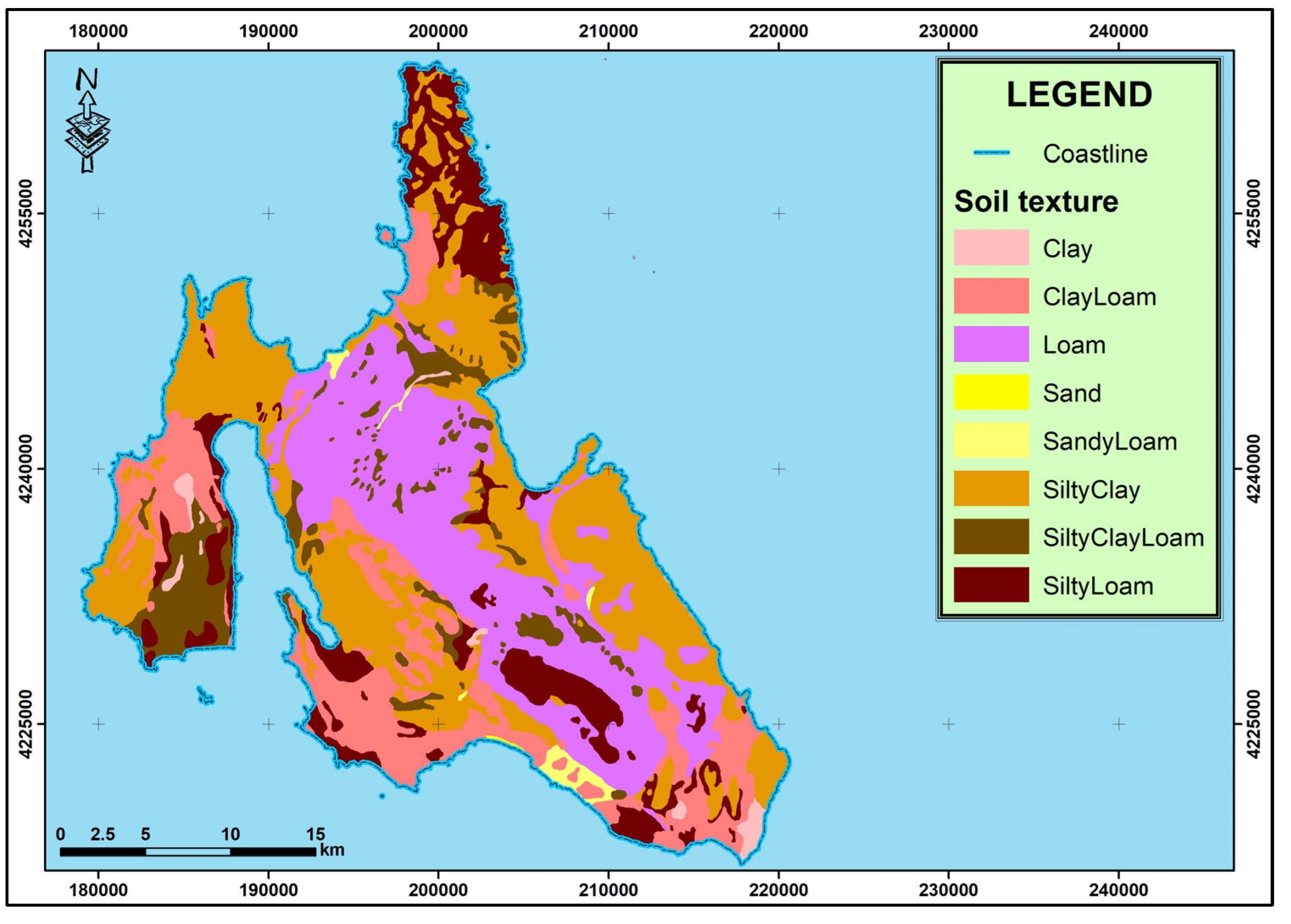
3.2. Soil Erodibility Factor (K)

The value of the soil erodibility factor (K) of the RUSLE soil loss equation is based on the soil characteristics and more specifically on soil texture, the percentage of sand, silt, and clay and organic matter. In the present study, the soil erodibility factor (K) was estimated from a soil map produced by a group of German pedologists that originated from the island of Cephalonia in 1950 led by German Professor Weinmann [14]. The result of the survey was the creation of a map of soil units following seven months of fieldwork and a study of approximately 40 soil pits covering the entire area of the island. Values were assigned as reported in [15] (Table 1). Soil erodibility factor (K) value varies from 0.12 to 0.41 t ha hMJ−1 mm−1. Figure 1 displays the spatial variability of the soil texture for Cephalonia Island.

3.3. Topographical Factor LS

The topographical factor is the union of two different factors, the slope length factor L and the slope steepness factor S. An increase in the value of either of the two factors causes a significant increase in soil erosion rates because steep slopes (S) provide high runoff velocities and larger slopes (L) store surface runoff from extensive areas as a result of the consequent rising runoff. Therefore, an increase of the values of both factors results in an increase of the value of soil erosion [16]. The above factors were calculated from the digital elevation model of Cephalonia Island that was created after the necessary processing. Topographical factor (LS) values vary from 0 to 819.174.

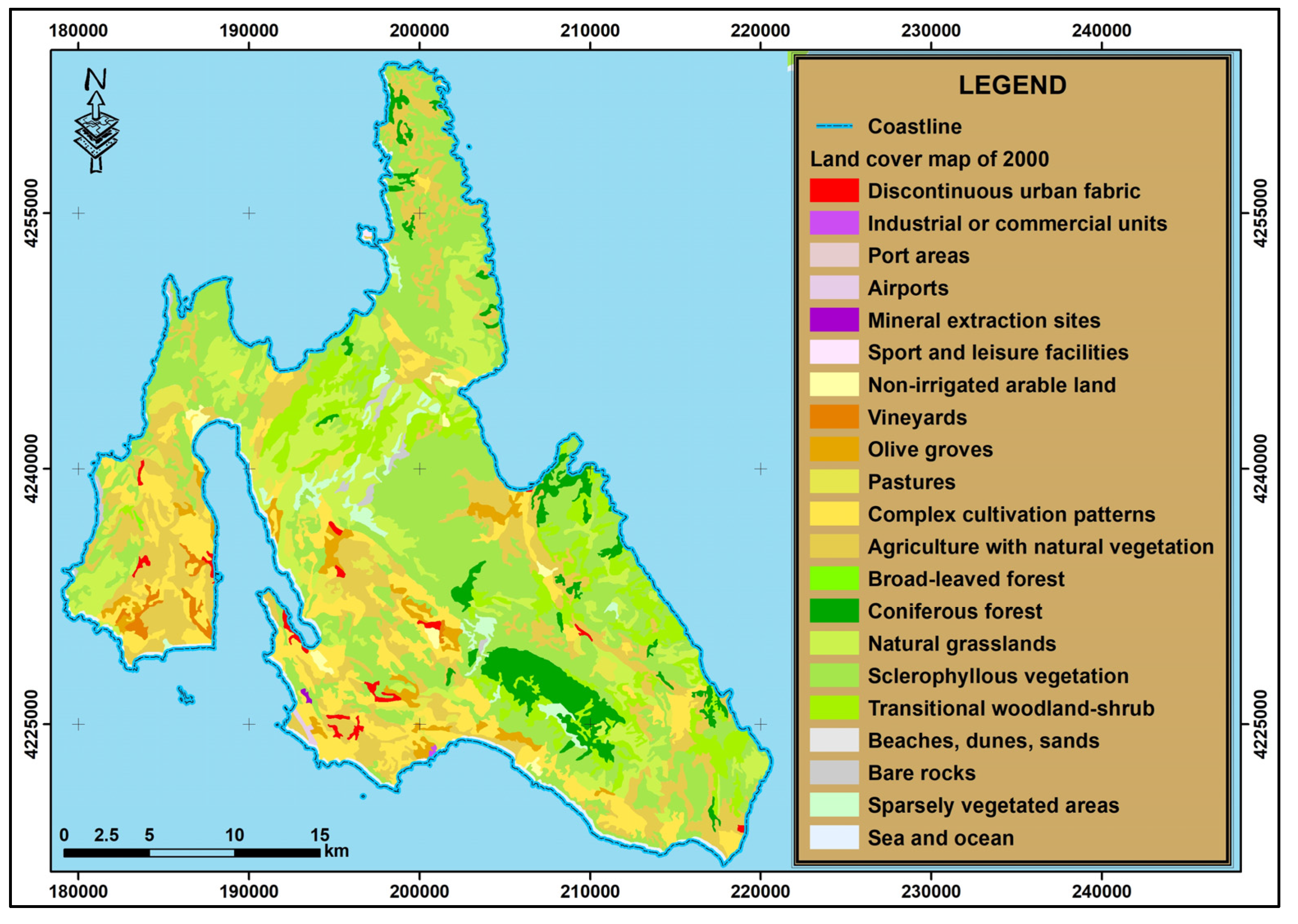
3.4. Vegetation Management Cover Factor (C)

For calculating the vegetation cover factor (C), vector land-use maps produced by the CORINE 2000 & 2012 land-cover program [17,18] were used in a scale of 1:100,000 with the corresponding land-cover codes. More specifically, in each land-cover code determined in the maps, a value for the vegetation management cover factor was assigned, which was determined either by utilizing values from the literature adapted to the description of the specific land uses [15,19] or by estimating new empirical values (Table 2). The resulting land cover maps of 2000 and 2012 are displayed in Figure 2.

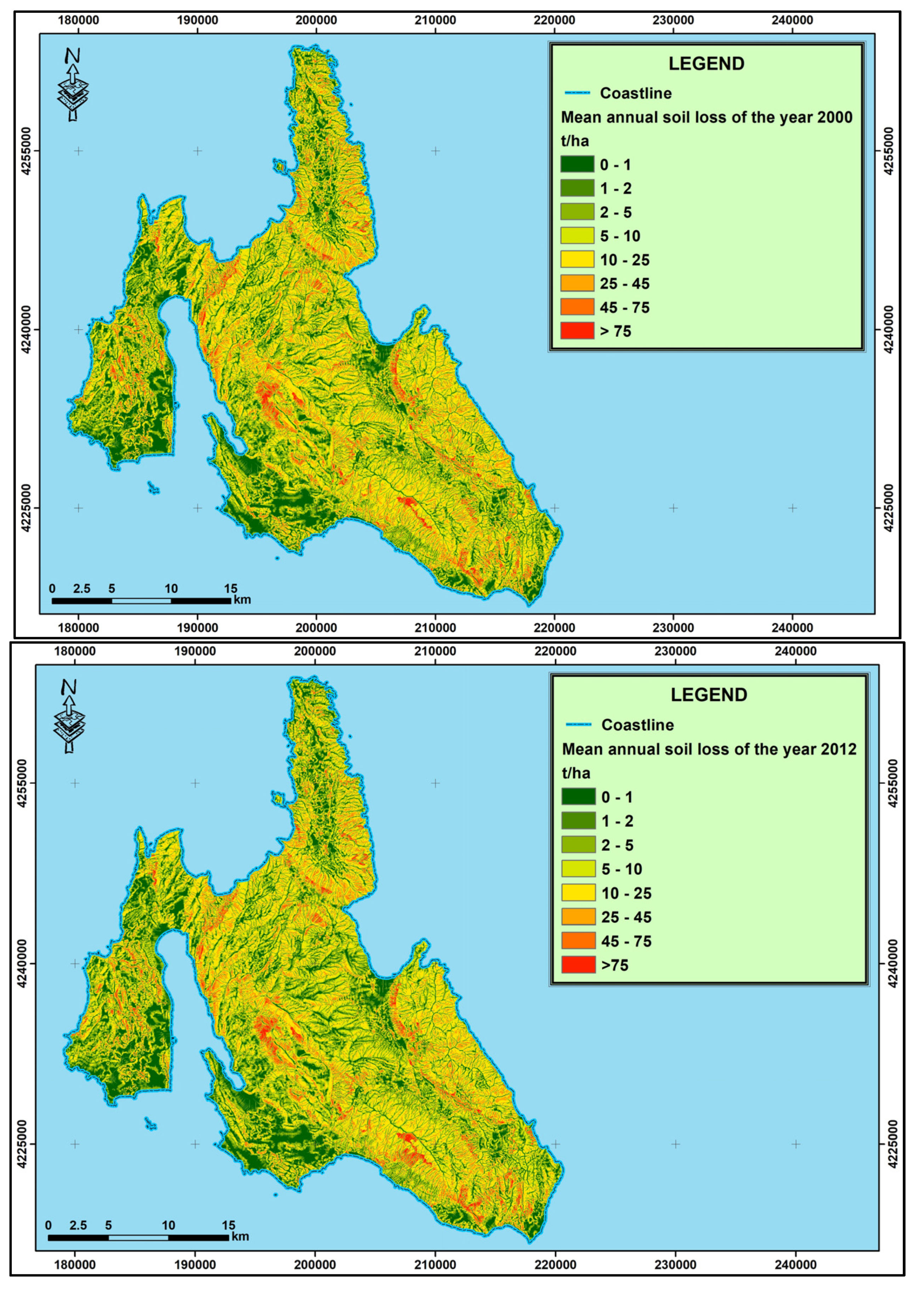
3.5. Mean Annual Soil Loss Rates (A)

The average annual soil erosion was estimated at 12.78 t/ha for the year 2000 and 12.28 t/ha for the year 2012. The resulting maps are displayed in Figure 3.

4. Discussion

The average annual soil loss was computed on a cell-by-cell basis using (1). The five factor raster maps representing the R, K, LS, C, and P factors were overlaid and multiplied with the ArcGIS Spatial Analyst extension [20]. The erosion map (Figure 3) displays the spatial distribution of soil loss in Cephalonia Island expressed as annual average soil loss in tonnes per hectare per year. The values should, however, be considered in a comparative manner rather than absolute values. This is because of the generalization of the input data used and the nature of the model. The results of the application of the RUSLE soil erosion equation demonstrate that 38.24% of the area of Cephalonia Island indicated moderate to significantly high erosion in 2012 compared to 40.55% in the year 2000 (Table 3). The southern, southeast, and eastern regions of the island indicate low erosion rates. Conversely, the areas (mainly agricultural and lowland areas) with low soil erosion rates of up to 10 t/ha increased in the period 2000–2012; this confirms the lack of erosion measures in the lowland and agricultural areas of the island. To obtain an improved general understanding and perform a superior comparison, the quantitative output of the soil loss prediction was classified into eight categories of increasing soil loss severity: <1 (none), 1 to 2 and 2 to 5 (very low), 5 to 10 (low), 10 to 25 (moderate), 25 to 45 (high), 45 to 75 (very high), and >75 t/ha year (severe). These erosion severity thresholds are consistent with those presented by other experts [21,22]. Further, this classification is consistent with the RUSLE model’s role as a conservation management tool, where relative comparisons among areas are more significant than any assessment of the absolute soil loss in a location.
Conversely, areas with high erosion rates were reduced in the period of study, which means that locally, vegetation and other protective agents have recovered from either fires or pressure from extensive livestock farming. Areas with high erosion rates are in the southern, southeastern part of Mount Aenos (Figure 3), in the area near the bay of Myrtos and Agia Kyriaki, in the Pylaros area.

5. Conclusions

Calculated island’s annual soil loss (Table 3) in 2012 indicates that 38.24% of total land area, are at risk of moderate to severe soil erosion. Survey analysis of the Cephalonian landscape carried out by the authors, concludes that large parts of the island are overgrazed or threated by forest fires. The steeply inclined mountain areas show the highest soil erosion rates (Figure 3). We concluded that in most cases socio-economic factors, common to Mediterranean countries, significantly contribute towards agricultural land abandonment and accelerated soil erosion.

Author Contributions

M.X. and P.M. conceived and designed the GIS analysis; M.X. performed the GIS analysis and produced the maps; M.X. and G.L. analyzed the data and performed field studies; M.X. wrote the paper; G.K. reviewed and corrected the paper.

Acknowledgments

The present work was performed by the resources of the Management Body of Mt. Aenos National Park and was financed by funds from the Financial Program: “Natural Environment—MBPP” 2017 of the Green Fund of Greece.

Conflicts of Interest

The authors declare no conflict of interest. The founding sponsors had no role in the design of the study; in the collection, analyses, or interpretation of data; in the writing of the manuscript, and in the decision to publish the results.

References

  1. Renschler, C.S.; Mannaerts, C.; Diekkruger, B. Evaluating spatial and temporal variability in soil erosion risk—Rainfall erosivity and soil loss ratios in Andalusia, Spain. Catena 1999, 34, 209–225. [Google Scholar] [CrossRef]
  2. Gobin, A.; Jones, R.; Kirkby, M.; Campling, P.; Govers, G.; Kosmas, C.; Gentile, A.R. Indicators for pan-European assessment and monitoring of soil erosion by water. Environ. Sci. Policy 2004, 7, 25–38. [Google Scholar] [CrossRef]
  3. Oldeman, L.R.; Hakkeling, R.A.; Sombroek, G.W. World Map of the Status of Human-Induced Soil Degradation: An Explanatory Note, 2nd ed.; International Soil Reference and Information Centre: Nairobi, Kenya, 1991; p. 35. [Google Scholar]
  4. European Environment Agency. Environment in the European Union at the Turn of the Century; Office for Official Publications of the European Communities: Luxembourg, 1999; p. 44. ISBN 92-828-6775-7. Available online: https://www.eea.europa.eu/publications/92-9157-202-0-sum/eu_98_uk.pdf (accessed on 6 December 2017).
  5. Fistikoglu, O.; Harmancioglu, Ν.Β. Integration of GIS with USLE in Assessment of Soil Erosion. Water Res. Manag. 2002, 16, 447–467. [Google Scholar] [CrossRef]
  6. Lykoudi, E.; Zarris, D. Identification of regions with high risk of soil erosion in the island Cephalonia using the universal soil loss equation. In Proceedings of the 6th Panhellenic Geographical Conference, Thessaloniki, Greece, 2–6 October 2002; pp. 412–419. [Google Scholar]
  7. Wischmeier, W.H.; Smith, D.D. Predicting Rainfall Erosion Losses: A Guide to Conservation Planning; USDA: Washington, DC, USA, 1978; p. 58. [Google Scholar]
  8. Renard, K.G.; Foster, G.R.; Weesies, G.A.; Mc-Cool, D.K.; Yoder, D.C. Predicting Soil Erosion by Water: A Guide to Conservation Planning with the Revised Soil Loss Equation (RUSLE); USDA: Washington, DC, USA, 1997; p. 384. [Google Scholar]
  9. Novotny, V.; Olem, H. Water Quality: Prevention, Identification, and Management of Diffuse Pollution; Wiley: New York, NY, USA; Hoboken, NJ, USA, 1994; p. 1072. [Google Scholar]
  10. Kirkby, M.J. Modelling water erosion processes. In Soil Erosion; Kirkby, M.J., Morgan, R.C., Eds.; Wiley: Chichester, UK, 1980; pp. 183–216. [Google Scholar]
  11. Zarris, D.; Lykoudi, E.; Koutsoyiannis, D. Appraisal of River Sediment Deposits in Reservoirs of Hydropower Dams; National Technical University: Athens, Greece, 2001; p. 243. [Google Scholar]
  12. Schwertmann, U.; Vogl, W.; Kainz, M. Bodenerosion Durch Wasser: Vorhersage des Abtrags und Bewertung von Gegenmassnahmen, 2nd ed.; Ulmer: Stuttgart, Germany, 1990; p. 58. [Google Scholar]
  13. Knijff, J.M.; Jones, R.A.; Montanarella, L. Soil Risk Assessment in Italy; European Soil Bureau: Brussels, Belgium, 2000; p. 52. [Google Scholar]
  14. Weinmann, B. Die Boden den Insel Kefallinia. Ph.D. Thesis, Justus-Liebig University, Giessen, Germany, 2 March 1964. [Google Scholar]
  15. MALta Soil Information System (MALSIS). A Soil Information System for The Maltese Islands LIFE 00/TCY/MT/000036 Report; Ministry of Agriculture and Fisheries: Valetta, Malta, 2003. [Google Scholar]
  16. Stefano, C.; Ferro, V.; Porto, P. Length Slope Factors for applying the Revised Universal Soil Loss Equation at Basin Scale in Southern Italy. J. Agric. Eng. Res. 2000, 75, 349–364. [Google Scholar] [CrossRef]
  17. Corine Land Cover 2000 Seamless Vector Data. Available online: https://www.eea.europa.eu/data-and-maps/data/clc-2000-vector-6 (accessed on 15 December 2017).
  18. Corine Land Cover 2012 Seamless Vector Data. Available online: https://www.eea.europa.eu/data-and-maps/data/clc-2012-vector (accessed on 15 December 2017).
  19. Hrissanthou, V.; Piliotis, A. Estimation of sediment inflow into a reservoir under construction. In Proceedings of the 6th Conference of the Greek Hydrotechnical Union, Thessaloniki, Greece, 22–26 May 1995; pp. 355–362. [Google Scholar]
  20. Mc Coy, J.; Johnston, K.; Kopp, S.; Borup, B.; Willison, J.; Payne, B. ArcGIS 9 Using ArcGIS Spatial Analyst; ESRI: Redlands, CA, USA, 2002; p. 238. [Google Scholar]
  21. Iraldo, F.; Meli, A.; Sacco, A.; DeBrincat, R.; Tamburini, F.; Bertoneri, F.; Rocchi, F. Development of Environmental Monitoring Strategy and Environment Monitoring Baseline Surveys; Malta Environmental and Planning Agency: Floriana, Malta, 2013. [Google Scholar]
  22. Gitas, I.Z.; Douros, K.; Minakou, C.; Silleos, G.N. Multi-Temporal Soil Erosion Risk Assessment in N. Chalkidiki Using a Modified Usle Raster Model. EARSeL eProceedings 2009, 8, 40–52. Available online: http://www.eproceedings.org/static/vol08_1/08_1_gitas1.pdf (accessed on 23 December 2017).
Figure 1. Soil erodibility factor (Κ) map of Cephalonia Island.
Proceedings 02 00618 g001
Figure 2. Vegetation management factor (C) maps of Cephalonia Island in the year 2000 (above) and 2012 (below).
Proceedings 02 00618 g002aProceedings 02 00618 g002b
Figure 3. Soil loss (A) map of Cephalonia Island in the years 2000 (above) and 2012 (below).
Proceedings 02 00618 g003
Table 1. K values as they were assigned according to soil texture [14,15].
Soil textureK FactorK Factor
Org. Matter Less than 2%Org. Matter More than 2%
Clay0.240.21
Clay Loam0.330.28
Loam1.500.26
Sand0.030.01
Sandy Loam0.140.12
Silty Clay0.270.26
Silty Clay Loam0.350.30
Silty Loam0.410.37
Table 2. C values as they were assigned according to land cover map [15].
Land Cover TypeLand Cover CodeC Factor
Continuous urban fabric1110.10
Discontinuous urban fabric1120.10
Industrial or commercial units1210.10
Port areas1230.10
Airports1240.10
Mineral extraction sites1310.15
Sport and leisure facilities1420.20
Non-irrigated arable land2110.50
Vineyards2210.40
Olive groves2230.40
Pastures2310.25
Complex cultivation patterns2420.40
Agriculture with natural vegetation2430.80
Broad-leaved forest3110.15
Coniferous forest3120.10
Mixed forest3130.15
Natural grasslands3210.25
Sclerophyllous vegetation3230.20
Transitional woodland-shrub3240.15
Beaches, dunes, sands3310.80
Bare rocks3320.05
Sparsely vegetated areas3330.60
Inland marshes4110.15
Table 3. Area occupied by each soil loss rate class for the years 2000 and 2012.
Soil Loss Rate (t/ha)Category(Year 2000) Area (%)(Year 2012) Area (%)Difference
0–1None20.0420.490.45
1–2Very Low5.265.770.51
2–514.4115.401.00
5–10Low19.7420.100.36
10–25Moderate27.9926.14−1.85
25–45High7.967.66−0.30
45–75Very High3.002.92−0.08
>75Severe1.601.52−0.08
Publisher’s Note: MDPI stays neutral with regard to jurisdictional claims in published maps and institutional affiliations.

