Regional Landsat-Based Drought Monitoring from 1982 to 2014


Abstract
:1. Introduction
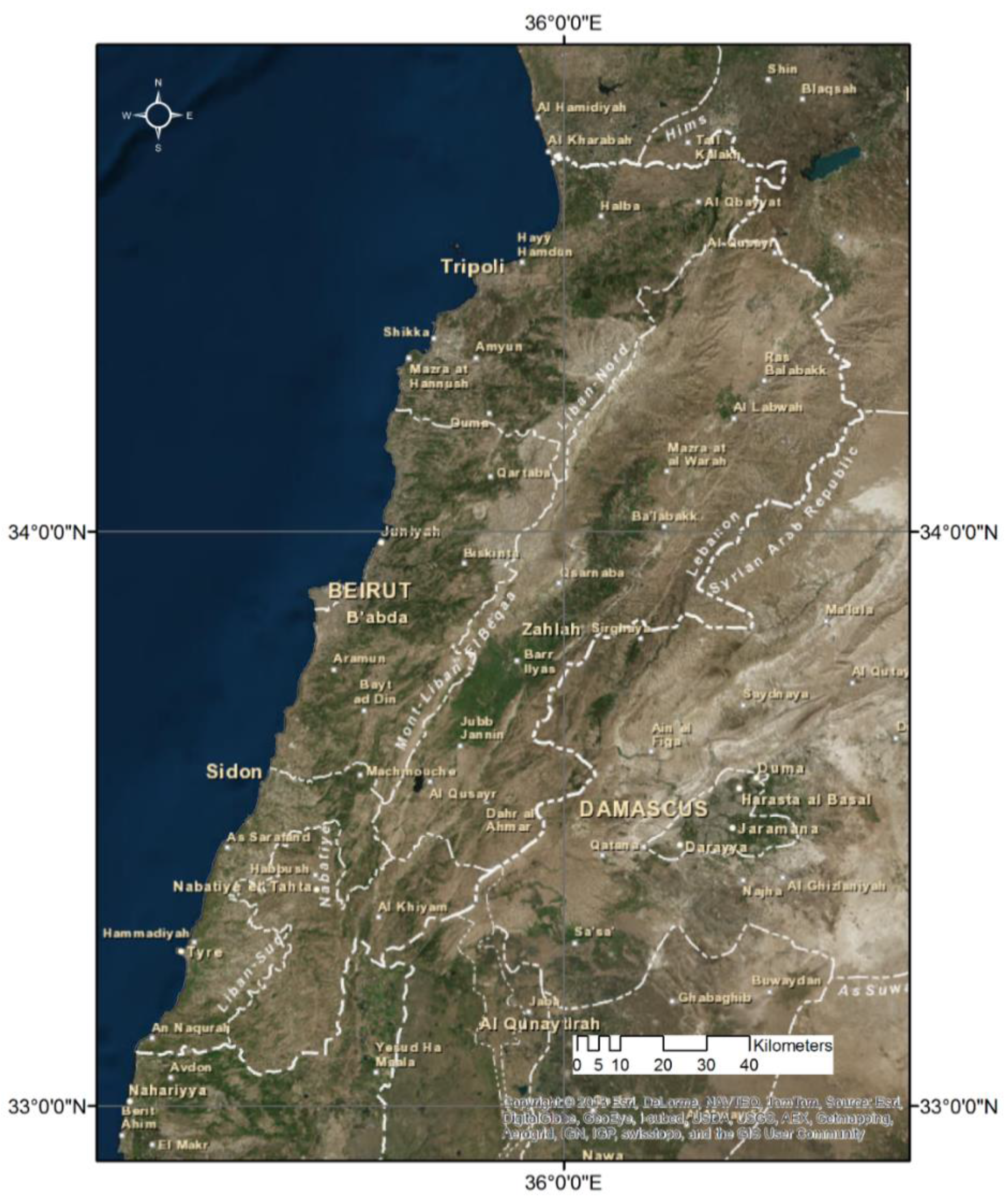
2. Study Area
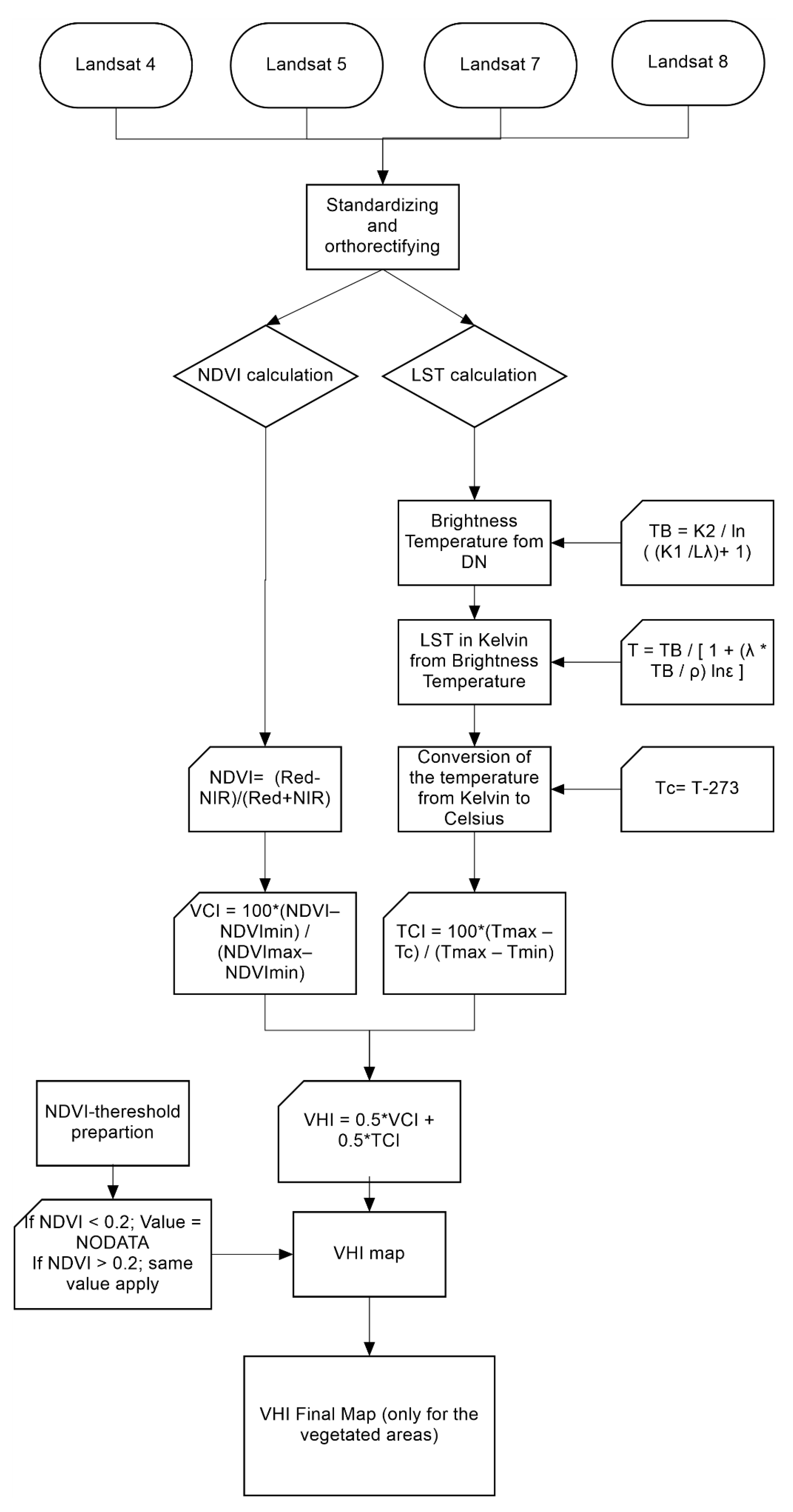
3. Data and Methods
3.1. Data Background
3.2. Methodology
3.2.1. NDVI
3.2.2. LST

| Processing Steps | Formulas | |
|---|---|---|
| Conversion of DN (Digital Number) to At-Satellite Brightness Temperature |
| |
| Calculation of the Land Surface Temperature in Kelvin |
| |
| Conversion from Kelvin to Celsius |
|
| Constant | Landsat 4 | Landsat 5 | Landsat 7 | Landsat 8 (Band 10) | Landsat 8 (Band 11) |
|---|---|---|---|---|---|
| K1 (watts/meter squared * ster * μm) | 671.62 | 607.76 | 666.09 | 774.89 | 480.89 |
| K2 (Kelvin) | 1284.30 | 1260.56 | 1282.71 | 1321.08 | 1201.14 |
| Satellite | Band | Center Wavelength (μm) |
|---|---|---|
| Landsat 4, 5, and 7 | 6 | 11.45 |
| Landsat 8 | 10 | 10.8 |
| Landsat 8 | 11 | 12 |
3.2.3. VCI, TCI and VHI
- NDVI, NDVImin, and NDVImax are the seasonal average of the smoothed weekly NDVI, its multiyear absolute minimum and its maximum, respectively;
- Tc, Tmin, and Tmax are similar values for land surface temperature in Celsius.
| Drought | Values |
|---|---|
| Extreme | <10 |
| Severe | <20 |
| Moderate | <30 |
| Mild | <40 |
| No | ≥40 |
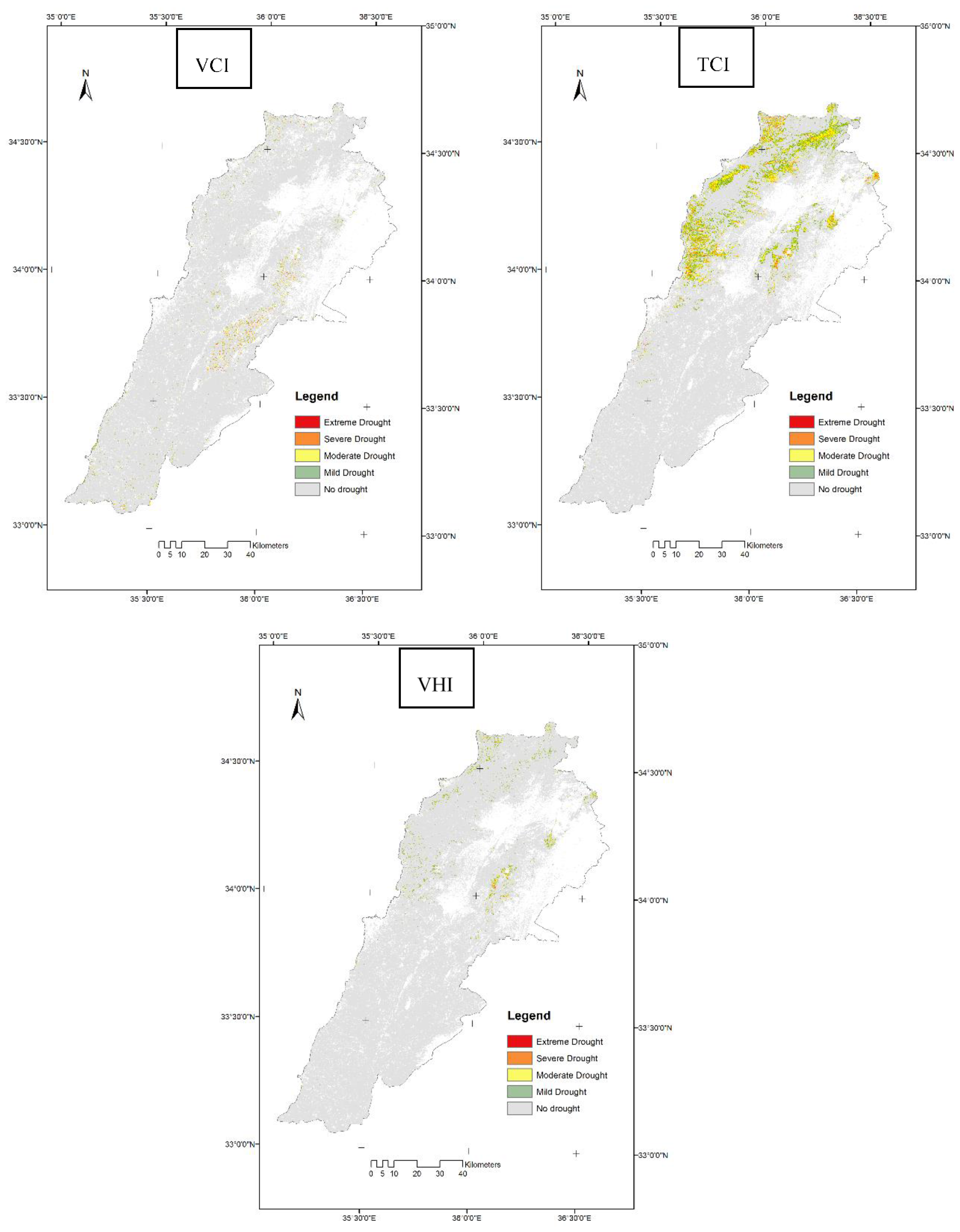
4. Results
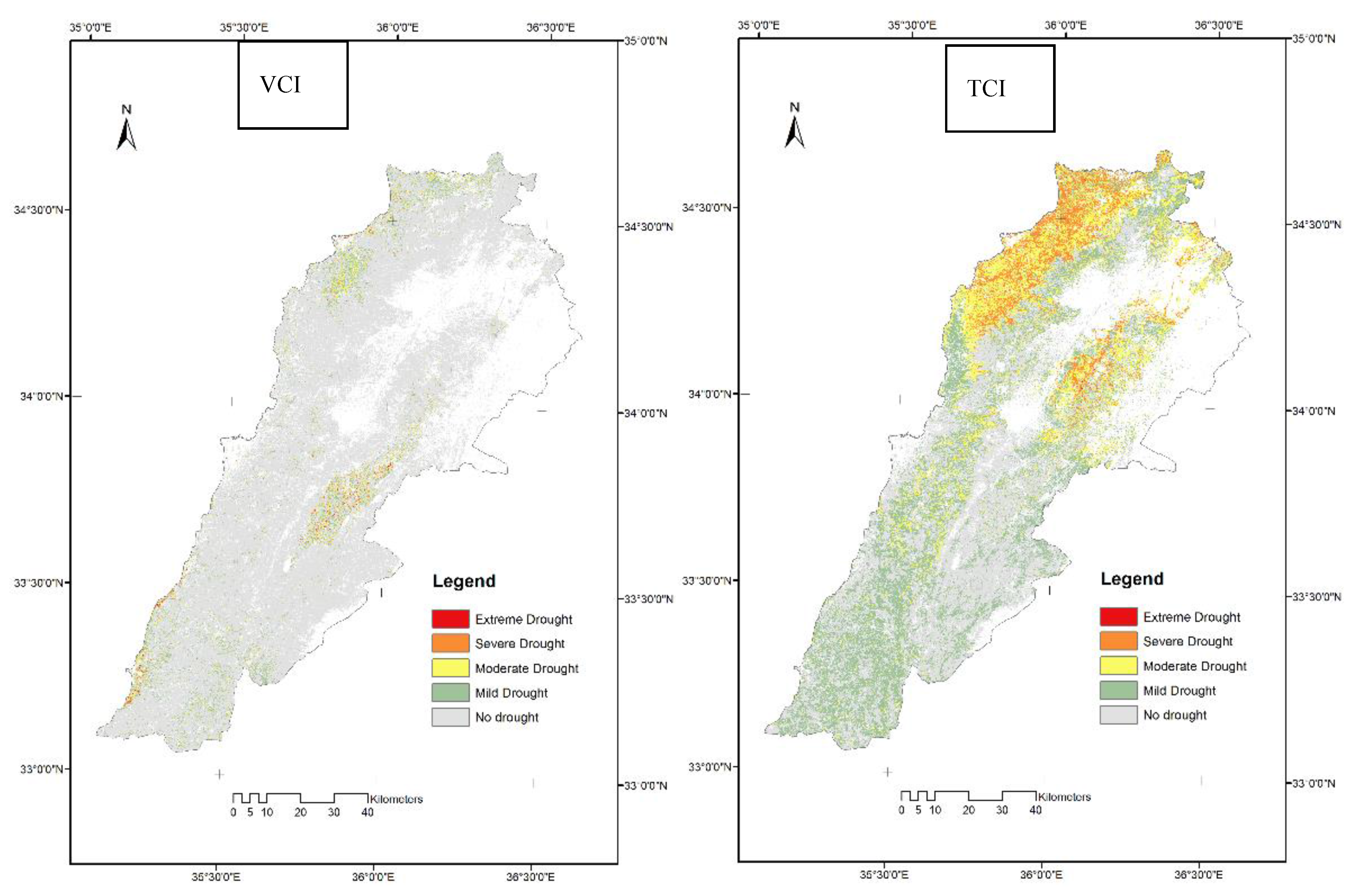
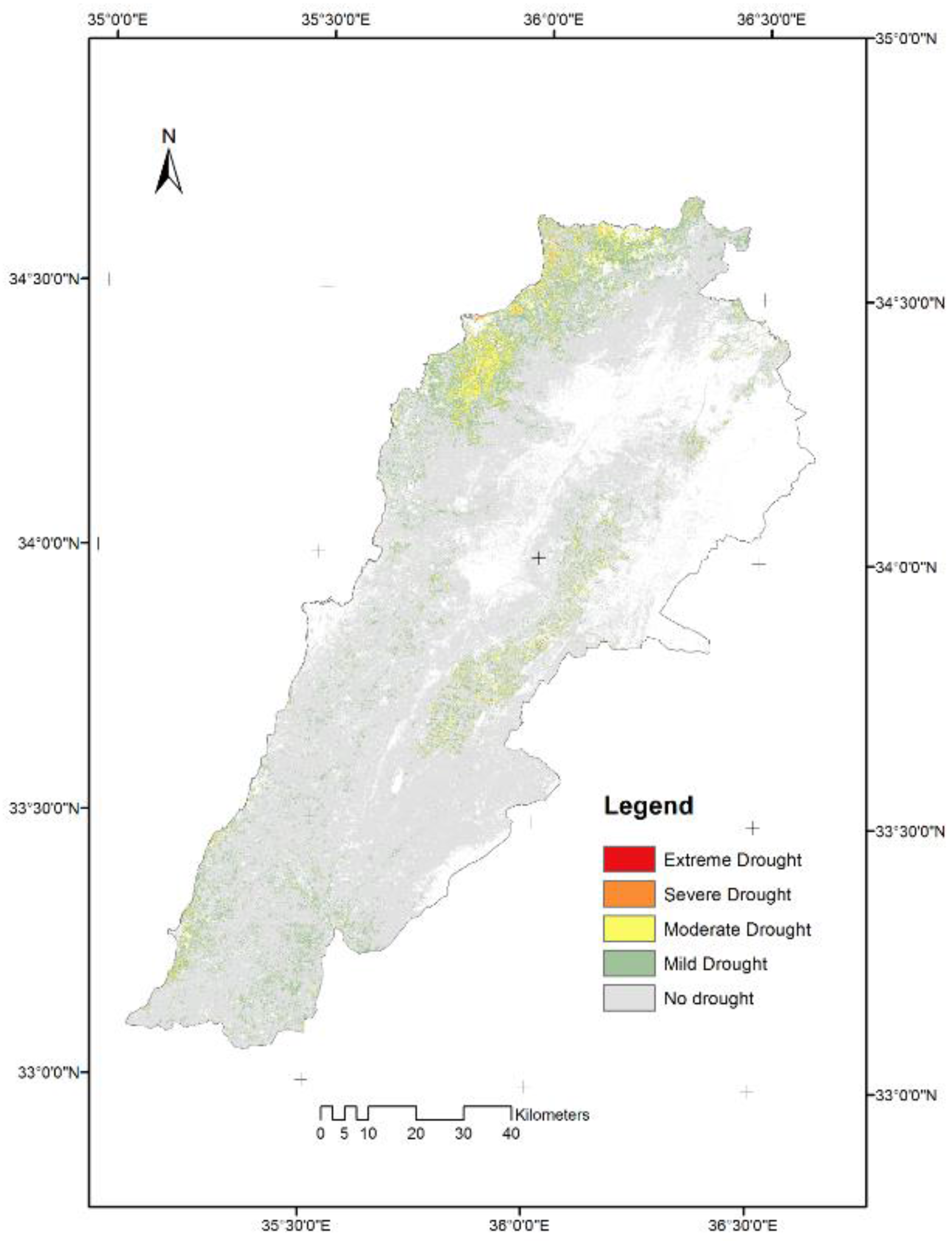
| Drought | Area in km2 | Area in Percentage |
|---|---|---|
| Extreme | 0.27 | <0.01 |
| Severe | 22.62 | 0.32 |
| Moderate | 268.41 | 3.80 |
| Mild | 907.35 | 12.84 |
| No | 5868.79 | 83.04 |
5. Discussion

6. Conclusions
Author Contributions
Conflicts of Interest
References
- Food and Agriculture Organization of the United Nations. Drought Facts. Available online: http://www.fao.org/docrep/017/aq191e/aq191e.pdf (accessed on 15 June 2015).
- Niemeyer, S. New drought indices. In Proceedings of the 1st International Conference Drought Management: Scientific and Technological Innovations, Zaragoza, Spain, 2–14 June 2008.
- The National Drought Mitigation Center (NDMC). University of Nebraska, Lincoln. Available online: http://drought.unl.edu/DroughtBasics/TypesofDrought.aspx (accessed on 19 October 2014).
- Wilhite, D.A.; Michael, H.G. Understanding: The drought phenomenon: The role of definitions. Water Int. 1985, 10, 111–120. [Google Scholar] [CrossRef]
- Dai, A. Drought under global warming: A review. Wiley Interdiscip. Rev. 2011, 2, 45–65. [Google Scholar] [CrossRef]
- Palmer, W.C. Meteorological Drought; Office of Climatology, U.S. Weather Bureau: Washington, DC, USA, 1965.
- Huang, S.; Devendra, D.; Claudia, Y.; Gyanesh, C.; Liu, S. Integration of Palmer Drought Severity Index and remote sensing data to simulate wetland water surface from 1910 to 2009 in Cottonwood Lake area, North Dakota. Remote Sens. Environ. 2011, 115, 3377–3389. [Google Scholar] [CrossRef]
- McKee, T.B.; Doesken, N.J.; Kleist, J. The relationship of drought frequency and duration to time scales. In Proceedings of the 8th Conference on Applied Climatology; American Meteorological Society: Boston, MA, USA, 1993; Volume 17, pp. 179–183. [Google Scholar]
- Palmer, W.C. Keeping track of crop moisture conditions, nationwide: The new crop moisture index. Weatherwise 1968. [Google Scholar] [CrossRef]
- Hayes, M.J. What is Drought? Drought Indices. Available online: http://drought.unl.edu/planning/monitoring/comparisonofindicesintro.aspx (accessed on 20 June 2015).
- Tucker, C.J.; Vanpraet, C.; Boerwinkel, E.; Gaston, E.A. Satellite remote sensing of total dry matter production in the Senegalese Sahel. Remote Sens. Environ. 1983, 13, 461–474. [Google Scholar] [CrossRef]
- Wilhite, D.A. Drought and Water Crises: Science, Technology, and Management Issues; CRC Press: Boca Raton, FL, USA, 2005. [Google Scholar]
- Di, L.; Shen, Y.; Sun, A.; Hong, Y.; Longuevergne, L.; Yang, Y.; Li, B.; Chen, L. Drought and flood monitoring for a large karst plateau in Southwest China using extended GRACE data. Remote Sens. Environ. 2014, 155, 145–160. [Google Scholar]
- Caccamo, G.; Chisholm, L.A.; Bradstock, R.A.; Puotinen, M.L. Assessing the sensitivity of MODIS to monitor drought in high biomass ecosystems. Remote Sens. Environ. 2011, 115, 2626–2639. [Google Scholar] [CrossRef]
- Rhee, J.; Im, J.; Carbone, G.J. Monitoring agricultural drought for arid and humid regions using multi-sensor remote sensing data. Remote Sens. Environ. 2010, 114, 2875–2887. [Google Scholar] [CrossRef]
- Zhang, X.; Susan Moran, M.; Zhao, X.; Liu, S.; Zhou, T.; Ponce-Campos, G.E.; Liu, F. Impact of prolonged drought on rainfall use efficiency using MODIS data across China in the early 21st century. Remote Sens. Environ. 2014, 150, 188–197. [Google Scholar] [CrossRef]
- Mladenova, I.E.; Jackson, T.J.; Njoku, E.; Bindlish, R.; Chan, S.; Cosh, M.H.; Holmes, T.R.H.; de Jeu, R.A.M.; Jones, L.; Kimball, J.; et al. Remote monitoring of soil moisture using passive microwave-based techniques—Theoretical basis and overview of selected algorithms for AMSR-E. Remote Sens. Environ. 2014, 144, 97–213. [Google Scholar]
- Zhang, A.; Jia, G. Monitoring meteorological drought in semiarid regions using multi-sensor microwave remote sensing data. Remote Sens. Environ. 2013, 134, 12–23. [Google Scholar] [CrossRef]
- Bayarjargal, Y.; Karnieli, A.; Bayasgalan, M.; Khudulmur, S.; Gandush, C.; Tucker, C.J. A comparative study of NOAA–AVHRR derived drought indices using change vector analysis. Remote Sens. Environ. 2006, 105, 9–22. [Google Scholar] [CrossRef]
- Rojas, O.; Vrieling, A.; Rembold, F. Assessing drought probability for agricultural areas in Africa with coarse resolution remote sensing imagery. Remote Sens. Environ. 2011, 115, 343–352. [Google Scholar] [CrossRef]
- Ji, L.; Peters, A.J. Assessing vegetation response to drought in the northern Great Plains using vegetation and drought indices. Remote Sens. Environ. 2003, 87, 85–98. [Google Scholar] [CrossRef]
- Unganai, L.S.; Kogan, F.N. Drought monitoring and corn yield estimation in Southern Africa from AVHRR data. Remote Sens. Environ. 1998, 63, 219–232. [Google Scholar] [CrossRef]
- Choi, M.; Hur, Y. A microwave-optical/infrared disaggregation for improving spatial representation of soil moisture using AMSR-E and MODIS products. Remote Sens. Environ. 2012, 124, 259–269. [Google Scholar] [CrossRef]
- Heumann, B.W.; Seaquist, J.W.; Eklundh, L.; Jönsson, P. AVHRR derived phenological change in the Sahel and Soudan, Africa, 1982–2005. Remote Sens. Environ. 2007, 108, 385–392. [Google Scholar] [CrossRef]
- Mahyou, H.; Karrou, M.; Mimouni, J.; Mrabet, R.; El Mourid, M. Drought risk assessment in pasture arid Morocco through remote sensing. Afr. J. Environ. Sci. Technol. 2010, 4, 845–852. [Google Scholar]
- Abdrabbo, M.A.; Farag, A.; Abul-Soud, M.; El-Mola, M.M.; Moursy, F.S.; Sadek, I.I.; Hashem, F.A.; Taqi, M.O.; El-Desoky, W.M.S.; Shawki, H.H. Utilization of satellite imagery for drought monitoring in Egypt. World Rural Obs. 2012, 4, 27–37. [Google Scholar]
- AL-Timimi, Y.K.; George, L.E.; AL-Jiboori, M.H. Drought risk assessment in Iraq using remote sensing and GIS techniques. Iraqi J. Sci. 2012, 53, 1078–1082. [Google Scholar]
- Erian, W.; Katlan, B.; Babah, O. Drought Vulnerability in the Arab Region, Case Study-Drought in Syria; Arab Center for the Studies of Arid Zones and Dry Lands and United Nations International Strategy for Disaster Reduction: Geneva, Switzerland, 2011. [Google Scholar]
- Amin, O.M.; Jan, A.; Mehrdad, R.; Ali, M.; R Afshin, S. Drought monitoring methodology based on AVHRR images and SPOT vegetation maps. J. Water Resour. Prot. 2011, 3, 325–334. [Google Scholar]
- Dash, P.; Göttsche, F.M.; Olesen, F.S.; Fischer, H. Land surface temperature and emissivity estimation from passive sensor data: Theory and practice-current trends. Int. J. Remote Sens. 2002, 23, 2563–2594. [Google Scholar] [CrossRef]
- Van de Griend, A.A.; Owe, M. On the relationship between thermal emissivity and the normalized difference vegetation index for natural surfaces. Int. J. Remote Sens. 1993, 14, 1119–1131. [Google Scholar] [CrossRef]
- USGS (U.S. Geological Survey). Landsat 8 (L8) Operational Land Imager (OLI) and Thermal Infrared Sensor (TIRS): Calibration Notices. Available online: http://landsat.usgs.gov/calibration_notices.php (accessed on 15 June 2015).
- Kogan, F.; Stark, R.; Gitelson, A.; Jargalsaikhan, L.; Dugrajav, C.; Tsooj, S. Derivation of pasture biomass in Mongolia from AVHRR-based vegetation health indices. Int. J. Remote Sens. 2004, 25, 2889–2896. [Google Scholar] [CrossRef]
- Kogan, F.N. Application of vegetation index and brightness temperature for drought detection. Adv. Space Res. 1995, 15, 91–100. [Google Scholar] [CrossRef]
- Kogan, F.; Gitelson, A.; Zakarin, E.; Spivak, L.; Lebed, L. AVHRR-based spectral vegetation Index for quantitative assessment of vegetation state and productivity. Photogramm. Eng. Remote Sens. 2003, 69, 899–906. [Google Scholar] [CrossRef]
- Bhuiyan, C. Desert vegetation during droughts: Response and sensitivity. Int. Arch. Photogramm. Remote Sens. Spat. Inf. Sci. 2008, 37, 907–912. [Google Scholar]
- Karnieli, A.; Agam, N.; Pinker, R.T.; Anderson, M.; Imhoff, M.L.; Gutman, G.G.; Panov, N.; Goldberg, A. Use of NDVI and land surface temperature for drought assessment: Merits and limitations. J. Clim. 2010, 23, 618–633. [Google Scholar] [CrossRef]
© 2015 by the authors; licensee MDPI, Basel, Switzerland. This article is an open access article distributed under the terms and conditions of the Creative Commons Attribution license (http://creativecommons.org/licenses/by/4.0/).
Share and Cite
Ghaleb, F.; Mario, M.; Sandra, A.N. Regional Landsat-Based Drought Monitoring from 1982 to 2014. Climate 2015, 3, 563-577. https://doi.org/10.3390/cli3030563
Ghaleb F, Mario M, Sandra AN. Regional Landsat-Based Drought Monitoring from 1982 to 2014. Climate. 2015; 3(3):563-577. https://doi.org/10.3390/cli3030563
Chicago/Turabian StyleGhaleb, Faour, Mhawej Mario, and Abou Najem Sandra. 2015. "Regional Landsat-Based Drought Monitoring from 1982 to 2014" Climate 3, no. 3: 563-577. https://doi.org/10.3390/cli3030563