Place and City: Toward Urban Intelligence


1
Nova Information Management School (NOVA IMS), Universidade Nova de Lisboa, Campus Campolide, 1070-312 Lisbon, Portugal
2
GEOTEC, Institute of New Imaging Technologies, Universitat Jaume I, Av. Vicente Sos Baynat s/n, 12071 Castellón de la Plana, Spain
3
Centre for Research in Geomatics, Université Laval, Québec, QC G1V 0A6, Canada
*
Author to whom correspondence should be addressed.
ISPRS Int. J. Geo-Inf. 2018, 7(9), 346; https://doi.org/10.3390/ijgi7090346
Submission received: 17 July 2018
/
Revised: 11 August 2018
/
Accepted: 20 August 2018
/
Published: 23 August 2018
(This article belongs to the Special Issue Place-Based Research in GIScience and Geoinformatics)
Abstract
:Place, as a concept, is subject to a lively, ongoing discussion involving different disciplines. However, most of these discussions approach the issue without a geographic perspective, which is the natural habitat of a place. This study contributes to this discourse through the exploratory examination of urban intelligence utilizing the geographical relationship between sense of place and social capital at the collective and individual level. Using spatial data collected through a web map-based survey, we perform an exhaustive examination of the spatial relationship between sense of place and social capital. We found a significant association between sense of place and social capital from a spatial point of view. Sense of place and social capital spatial dimensions obtain a non-disjoint relationship for approximately half of the participants and a spatial clustering when they are aggregated. This research offers a new exploratory perspective for place studies in the context of cities, and simultaneously attempts to depict a platial–social network based on sense of place and social capital, which cities currently lack.
1. Introduction
Over the last 40 years in geographic information science (GISc), there has been a growing interest in the idea of place in regard to its suitability compared to space for the understanding of social dynamics [1]. Typically, GISc has been primarily focused on quantitative and observable facts due to the readability of empirical phenomena [2]. Nevertheless, currently, the possibility of collecting qualitative and social evidence with new data and approaches, such as volunteered geographic information (VGI) [3] and softGIS methods [4,5], has generated a broad interest in better understanding social synergies in the city context. Conversely, to some extent, the smart city and its mainly technological nature has hidden the opportunity of a citizen-centric approach [6] in which place acquires a central role.
The citizen-centric smart city approach bases itself on the human–environment interactions which are mainly dependent on our capability to understand platial (in this research, platial is concerned about the space-based geography that is focused on human discourses, social values, and human–space interactions [1]) urban dynamics. Although the concept of urban dynamics can also apply to communities, governments, and business, this research focuses on citizenship at the individual level. The operationalization of those individual–environment interactions is closely related to the notion of urban intelligence. Roche [1] describes the concept of urban intelligence as the urban stakeholders’ ability to depict the connected complex urban places (i.e., platial urban dynamics). Hence, smart cities are not only continuous spaces crowded with quantitative data and sensors; they are also about complex place dynamics based on citizens interactions, for instance, with respect to places (sense of place (SoP)) or social relationships (social capital (SC)). However, the few studies that cover the practical exploration of place in multiple disciplines seem to suffer (among others) from the difficulty in defining its spatial dimension. Currently, in order to understand the urban intelligence of a city, we are using the sensing part of urban engineering (i.e., sensors, location-based and context aware services), but the challenge is to go one step further and comprehend the individual spatialities (individual spatialities in this research are adapted from Lussault [7] as the individual or collective practices related to their geographical location and to one another that reflect their spatial actions and interactions) to infer the platial dynamic system hidden in the smart city context. Thus, we can discern two visions to grasp the smart city environment: one based on the urban engineering and its location-based technological paradigm as (dynamic) layers along the city, and its social parallel, an image of the city built on the dynamics of urban intelligence as a network of places. The latter approach highlights a scenario in which the need for new bottom–up place-based information [3,8] becomes more and more important.
In this paper, we study the spatial relationship between SoP and SC to gain a better understanding of the city dynamics that are dependent on the spatial organization of place. We attempt to simplify the complexity of place dynamics with the spatialization of SoP and SC as a possible dynamic geographical arrangement to infer place. Despite being aware that citizens are spatially sticky [9] and that they are used to creating ties where they develop their daily tasks, there is a paucity of literature on the connection of SoP and SC toward the spatial notion of place. For the inclusion of place and platial urban dynamics into the smart city realm and its analytical use, there is a need for in-depth exploratory research on dynamic human spatiality boundaries, and therefore, a need to address their space–time distribution [10]. The objectives of this exploratory study are (1) to examine citizen-defined place dynamics (i.e., urban dynamics), including the spatial dimensions of citizens’ SoP and SC at the individual and collective level, in the urban domain; and (2) to provide a first definition of the spatial relationship between SoP and SC at the individual level. This article starts with a review of place in the smart cities and the spatialization of the related place concept in terms of SoP and SC. The article then presents the methods and the results of an experiment conducted in Lisbon (Portugal) to clarify the spatial relationship between SoP and SC, and its connection with urban intelligence. This is followed by a discussion of the results, the remaining gaps and limitations, as well as the reasoning of our findings to offer new insights into the notion of urban intelligence. We finish the manuscript with a conclusion and future work.
1.1. Place in the Smart City Context
Place, which is a space endowed with meaning [11,12], assigns context to space [13] and cannot be simplified into a basic concept (i.e., a spatial relationship) without losing its human connotation [14], which makes it unique in the universe [15]. Most conceptualizations of place in the literature [15,16,17,18,19,20,21] have a shared dimension: location. However, there is a lively debate about the spatial definition of place. Some researchers characterize place as the relational nature among entities in the geographic environment rather than by coordinates and geometric properties [22]. However, if we recognize the existence of place, it has to exist somewhere. Geographic information technologies have experienced challenges with the treatment of data dealing with qualitative meanings and feelings. To some extent, the latter issues are due to the spatial vagueness [23] and dynamism [1] of place compared to the Euclidean representation of space. In fact, Relph [12] argued that location is not a sufficient condition of place, while Cresswell [24] supported that place is never finished; instead, it is always becoming. In turn, place is one of the shared cornerstones in human geography, social science, GISc and environmental psychology. Hence, one can wonder: how can the spatial dimension of place be operationalized to help different disciplines? Unfortunately, as Goodchild and Li [25] assure, there has been a focus on the pure spatial domain of geographic information technologies in the past few decades. In contrast, we are currently witnessing an increasing interest in the study of dynamic concepts related to places. Fortunately, the surge of smart cities, with associated information and communication technology (ICT) research and tools, allows new ways of managing and collecting information about the urban environment. Currently, there are new approaches to understanding citizens’ interaction with the urban environment. For example, in user-generated content in general, and crowdsensing in particular, citizens are considered sensors [3] that supply a huge amount of geographical data with or without consent [26]. This (sometimes) invasive approach can evolve into a more cooperative process to gather and measure real sensing in the human–urban interaction.
Nowadays, there is an optimal environment and set of tools to create a comprehensive bridge between disciplines (e.g., human geography, environmental psychology, social science, and GISc), where the cornerstone is the shared spatial dimension of place. In turn, the combination of social concepts (e.g., SC and SoP) and GISc methods can play a crucial role in merging: (1) the human uniqueness in social science (e.g., citizen perceptions and feelings), (2) the interaction and structure of human behavior (e.g., social networks, relationships, and social events) and (3) the context specifications of location (e.g., landmarks [27] and spatial dependence). Although people’s experiences with their environment are becoming more mediated [28], researchers have focused on the measurement and conceptualization of place concepts, rather than its spatialization [29,30]. There is a need to understand how dwellers perceive their spatial surroundings (i.e., individual’ spatialities) to learn the multifunctional facet of the smart city based on the spatial organization of place (i.e., platial urban dynamics). This can bring to light urban platial dynamics, allowing their awareness by city stakeholders (i.e., urban intelligence). This sequence based on place provides a more citizen-centric smart city approach, i.e., to explore the dynamic platial–social network that is nowadays lacking in the smart city. Thus, the attempt to spatialize place-related social and environmental psychology concepts (i.e., SC and SoP, respectively) might give an opportunity to enable the city’s social synergies spatially. Figure 1 shows an overview of the layout that embeds all of the main concepts of this research. From this discussion, the question naturally arises: how can place-related concepts be spatially defined through GISc techniques?
1.2. The Spatial Dimension of Place-Related Concepts: Sense of Place and Social Capital
There is a need for additional research in the acquisition of psychological and social data through practical applications [31,32] in order to gather the individual’s dynamics [33] and emotions [34] toward places. The critical implications of the process of mapping through GISc methodologies (see Elwood [35]) and the inherent dynamism and boundary vagueness of rich concepts such as place, SoP, and SC seems to be crucial reasons why these concepts are not operationalized. Massey [36] has already defined the inherent problems of conceptualizing boundaries for the place notion, as it is a process of social interactions. Furthermore, the representation of complex and multifaceted concepts (i.e., place, SoP, SC) with geographic primitives (e.g., discrete points and/or polygons) can imply several difficulties and information loss [37]. Nevertheless, Massey [36] also asserts that for certain kinds of studies, boundaries of place are needed. Therefore, our study simulates and allows participants to define their SoP and SC’s spatial dimensions into geographic primitives (i.e., discrete polygons). This approach is also used in previous studies [38] that present polygons as the representation of people’s perceptions toward a place (e.g., place attachment). The ease of implementation of “standard” drawing tools to define polygons and users’ familiarity with that type of approach with respect to fuzzy designs [37] are an advantage, but it also implies limitations. The representation of vague concepts (i.e., place) through geographic primitives can presuppose a questionable accuracy and precision to define the spatial dimension of place-related concepts. Hence, this study introduces alternative analyses to anticipate different boundary natures on the capture of the spatial behavior of SoP and SC at a given time (see Section 2.2).
Most of the studies that measure SoP and SC are using and assuming a positive spatial relationship to pre-established administrative boundaries (i.e., neighborhood, parish, city, etc.). Yet, the residents’ perception of neighborhood boundaries, for instance, can spatially differ from the administrative and regulated neighborhoods [39,40,41]. Indeed, this contradistinction is also highlighting the different views of perceiving the city: as static administrative boundaries (i.e., space), or dynamic and fuzzy geographical areas based on citizens (i.e., place) [42]. In this paper, we aim to overcome this issue by studying the explicit spatial relationship between SoP and SC as independent concepts. This exploratory approach can add relevant subjective information about the endowed meaning of spaces, hereby contributing to the understanding of the urban intelligence based on place structure. At the same time, this information provides us with the capability to study how citizens comprehend and represent part of their place dynamics regarding SoP and SC.
1.2.1. Sense of Place
Sense of place (SoP) refers to the individual, not the place [43]. SoP is one of the three dimensions of Agnew’s place conceptualization [16,20], and human geographers have acknowledged it as a place dimension [44]. SoP is a complex and multidimensional concept [31] shaped by the feelings, beliefs and behaviors that humans associate with a place [34]. Measuring SoP is a complex task, especially when there is a need to measure it spatially. In any case, SoP and other place-related concepts, such as place attachment, place dependence, and place identity, are suitable to be spatially measured, since their affective bonds are toward a geographical area [45,46]. For instance, Brown et al. developed map-based methodologies to gather landscape values and place-related concepts (i.e., place attachment) for scales larger than a neighborhood [38,47,48,49]. The first attempt at measuring and mapping the notion of place attachment was conducted by Brown et al. [38]. They based their approach on home range conceptualization [50] and used an internet-based public participatory geographic information system (PPGIS) to gather all the required information. In another study, Jorgensen and Stedman [32] measured the spatial component of sense of place by integrating the spatial and physical features of places with attitude and behavioral variables using structural equation techniques. Recently, Jenkins et al. [51] merged Twitter data using social network analysis (SNA) and VGI from Wikipedia to spatialize a collective SoP.
Our research defines SoP as the cognitive, affective, and behavioral dimensions of the relationship that an individual has with a certain geographical area [34]. This conceptualization exhibits three dimensions (place attachment, place identity, and place dependence) based on the attitude theory [52] and proven by Pretty et al. [53]. Place attachment covers the affective perspective toward a place [54,55,56], while place identity relates the place and one’s personal identity [57]. Finally, place dependence comprises the acts and behaviors towards a place that meet the necessities of an individual with respect to other places [34].
1.2.2. Social Capital
Social capital (SC) analyzes the value of social relationships and networks to societies and individuals [58] from two perspectives: structuralism [59,60] and interactionism [61]. Roughly, the former is defined as the connection between nodes and links, while the latter focuses on the links that are built on top of these connections based on an individuals’ norms, preferences and attitudes [62]. SC is simultaneously an economic, sociological, and political [63] and psychological concept [64]. Geographers have been skeptical in the spatial envisioning of SC and have lost the opportunity to add the concept to the open dialogue in the social sciences [58]. Specifically, some authors consider that geographical SC is almost dead [65], while other authors argue for the potential of understanding and reconceptualizing SC geographically [9,58,66,67]. For instance, Foster et al. [68] measured the spatial dimension of SC encompassed in the cognitive neighborhood, while other researchers have extracted it from SNA [69,70]. In our research, SC refers to the relationships between human collectives [58] and the analysis of their values to individuals from a structuralist perspective.
2. Methodology
The methodology of this paper focuses on understanding the explicit spatial relationship between SoP and SC using different methods (see Section 2.2) in order to contribute to the body of knowledge regarding platial urban dynamics, and thus, urban intelligence. Hence, for this study, we define three types of spatial information for each citizen ():
- Geometry(-ies) that represent a participant’s Geographical SoP ( or GSoP) and their spatial union(s) ( or uGSoP) (a)
- Geometry(-ies) that illustrate a participant’s Geographical SC ( or GSC) and their spatial union(s) ( or uGSC) (b)
- A point that illustrates a participant’s home (hi)whererepresents the citizen.i is an integer number between 1 and n, where n is the total number of citizens in a given city.N and M are positive integers representing the total number of SoP and SC areas, respectively, for a citizen ().represents the union of all of the individual geographical sense of place(s) for a citizen ().represents the union of all of the individual geographical social capital(s) for a citizen ().
2.1. Data Collection: The Spatialization of Sense of Place and Social Capital
The method we present uses a public participation geographic information system (PPGIS) [71] based on the softGIS methodology [4,72] to collect the spatial dimensions of citizens’ SoP and SC. We centered our methodology around a PPGIS application for three main reasons. Firstly, our principal data (i.e., geometries representing SoP and SC) is spatial, and as such, a PPGIS approach provides a useful tool to gather that geographical information. Secondly, the nature of a PPGIS methodology is to broaden public involvement in policymaking [73], reveal its bottom–up possibilities, and provide qualitative knowledge essence [74]. Finally, its mainly online oriented approach enables surveys to take place more rapidly and to reach more people [75]. Furthermore, as was mentioned above, the most similar study to ours [38] also applied a PPGIS to gather the spatial dimension of place attachment. However, although Brown and Pullar [76] favored the use of points instead of polygons in PPGIS applications, our approach (and that of Brown et al. [38] as well) uses polygons to better accommodate the possible different spatial scales of the studied concepts (SoP and SC).
The PPGIS application used in this research combines the web-mapping activity with a series of questions related to the defined spatial features ((https://placeandcity.com) [accessed on 26 June]). This tool is open source, and therefore replicable and reusable ((https://github.com/aacedo/placeandcity-backend)(https://github.com/aacedo/placeandcity-frontend) [accessed on 26 June]). We defined a meticulous sequence of actions to guide participants to specify the user through attempting the definition of their GSoP and GSC spatial dimensions. The tool shows an explanation of the two concepts (i.e., SoP and SC), and requests the participants to think about their own places and social groups that comprise these two concepts, respectively. The definition of SoP is consistent with the place attachment, place identity, and place dependence conceptualization [34,53], while SC is surveyed based on Grootaert et al. [77] (see both questions in Table A1 in Appendix A). Once participants had considered what constitutes their SoP and SC, some instructions guided the participant to name, spatialize, and characterize the respective areas related to their SoP and SC (as many as needed) through spatial drawing tools on a base map centered on Lisbon city without any restrictions in terms of scale and location (for more information, see Acedo et al. [71]). The tool also provided a space for participants’ sociodemographic information (age, gender, profession, income and nationality).
2.2. Studying the Spatial Relationship between Sense of Place and Social Capital
As mentioned before, it is a challenge to define the boundaries of complex related place concepts through geographic primitives (see Section 1.2). In this study, we address the analysis of those geographic primitives gathered from three different analyses: point-based, area-based, and distance-based. We introduce alternative analyses that can complement each other to elucidate the suitability of different analytical levels (i.e., individual and collective) and anticipate different boundary natures (i.e., fuzzy and sharp). Sharp boundaries are geographic primitives (i.e., discrete polygons) to define, through the aforementioned PPGIS application, both GSoP and GSC. Fuzzy or vague boundaries, in this study, indicate a lack of a clear definition of boundaries, i.e., the interpretation of geographic boundaries without a clear definition of where or what they are [37]. We achieve those fuzzy boundaries with the estimation of the frequency of occurrence of GSoP and GSC (i.e., kernel density function) that illustrate collective fuzzy or vague spatial relationships. We handled the entire computational process with the database driver psycopg2 (http://initd.org/psycopg/docs/ [accessed on 26 June]) (PostgreSQL + Python); the collected data were stored in a relational geodatabase managed by PostgreSQL/PostGis and visualized in QGIS. Furthermore, we conducted some of the statistical analysis with R (https://www.r-project.org [accessed on 26 June]).
2.2.1. Point-Based Analysis
We calculated the centroids of GSoP and GSC and performed a spatial analysis of them based on spatial point patterns [78]. The simplification of GSoP and GSC to centroids answer the necessity of understanding at the collective level the distribution of those geographical areas. Although the centroids imply inaccuracy on the area extension, we treated them as primary elements to achieve fuzzy or vague geographical areas (see Section 3.2). We evaluated the spatial independent hypothesis for both types (SoP and SC) [79]. We also determined the intensity functions through the kernel density estimation [78,79,80]. Furthermore, we studied the univariate spatial distribution of each pattern (SoP and SC) with Ripley’s K function, and judged the hypothesis of complete spatial randomness. Finally, we used the cross-type K–function to investigate the possible spatial autocorrelation between the two concepts (SoP and SC) [78,79].
2.2.2. Distance-Based Analysis
We present two linear thresholds to study participants’ home and uGSoP–uGSC linear specific spatial relationships [81], respectively. The calculation of the Euclidean distance is always from the nearest point from uGSOP or uGSC to the participants’ home. We determine the following two linear thresholds (d1 and d2):
- d1: the first linear threshold is defined by the Hasanzadeh et al. [82] study. This article performed a literature review regarding the suitable spatial delimitation for defining home neighborhoods. Accordingly, 500 m is the most commonly used spatial delimitation.
2.2.3. Area-Based Analysis
We calculated the area of each GSoP and GSC to better understand the frequency distribution based on area. The areas of all of the participants were spatially intersected for each type (SoP and SC) to better understand locations with more SoP and SC, respectively. We combined all of the participants’ areas per type and counted the overlapping times between them. We also analyzed the explicit topological relation between the areas [88], and concretely, between the parishes and each uGSoP and uGSC.
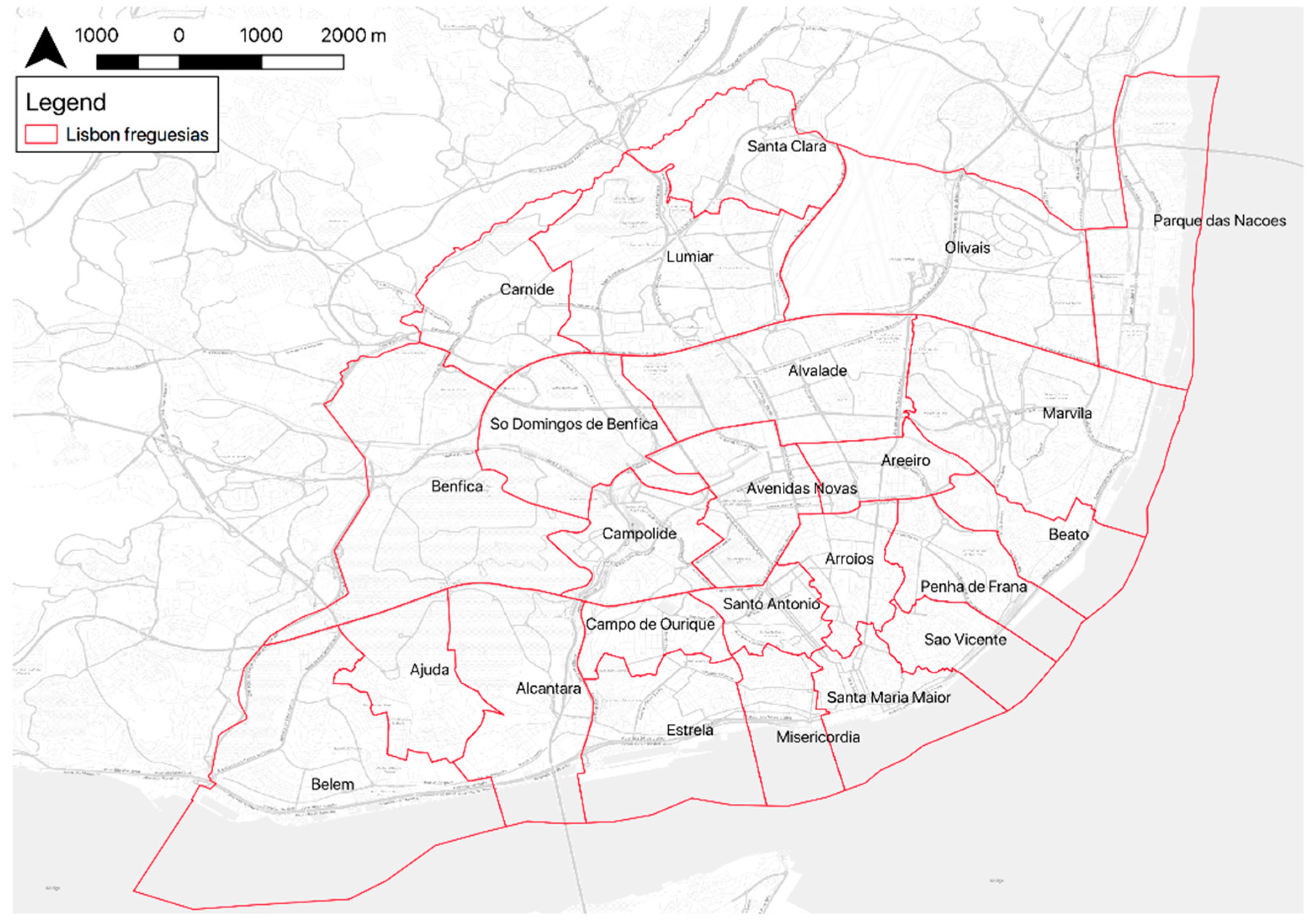
2.3. Study Area
The capital of Portugal, Lisbon, extends over an area of 100 square kilometers, and supports a population of over 500,000 people. In 2012, Lisbon suffered an important administrative restructuring, moving from 53 to 24 parishes (Figure 2). This adjustment considerably transformed Lisbon’s autonomous governments (freguesias) by changing their spatial distribution, names, and structures. Lisbon’s participatory department watches over participatory processes and tries to engage citizens in the different events of the 24 parishes. Our exploratory research is focused on Lisbon citizenship that has participated in these participatory processes from the different parishes. The survey was sent to the Lisbon participatory budgeting email database, which represents a sample of the general adult public that has participated (at least once) in Lisbon participatory processes using email. We applied a non-probabilistic sampling, specifically, a convenience sampling [89]. The Lisbon city council contacted the participants by email and requested them to answer the map-based web survey during a three-week period (12 June to 2 July 2017).
3. Results
All 373 participants drew at least one SoP area. For this study, we were only interested in areas defined within the Lisbon city boundary mapped by Lisbon citizens. Consequently, we obtained a dataset (n = 311), from which our primary concern was citizens that had defined both areas (SoP and SC) (n = 163). Table 1 shows their demographics.
There is a considerable variability in the size of both participants’ SoP and SC areas. For instance, just one participant identified one of his/her GSoP larger than a quarter of Lisbon extension (about 10,000 ha), while 107 of the areas established were less than a hectare. Indeed, 50% of the GSoP were smaller than 12 hectares. SC areas also had a high variability, although participants’ GSC were smaller in size than GSoP; about 50% of them were smaller than 8 ha.
3.1. Collective Level: Fuzzy Understanding of Place Urban Dynamics
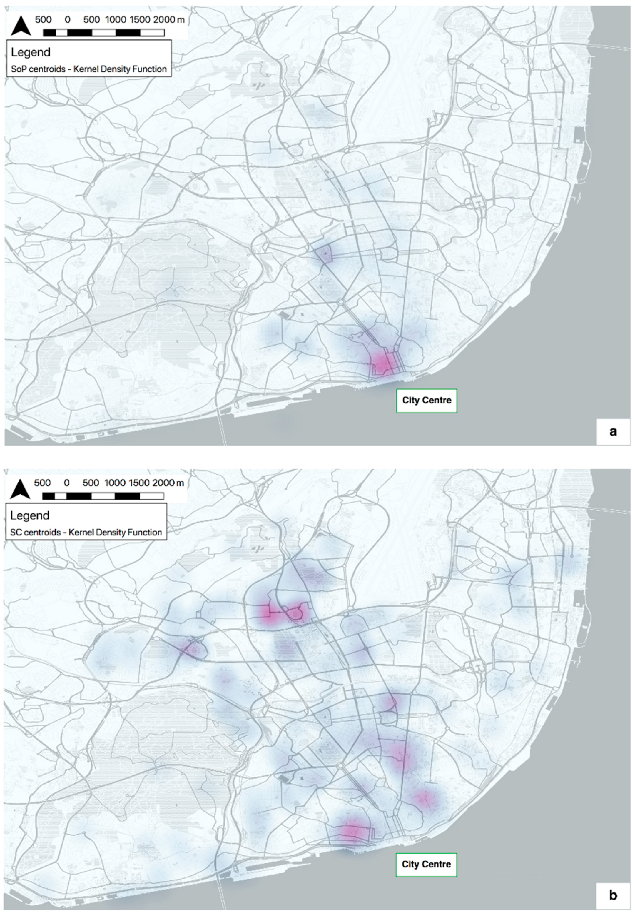
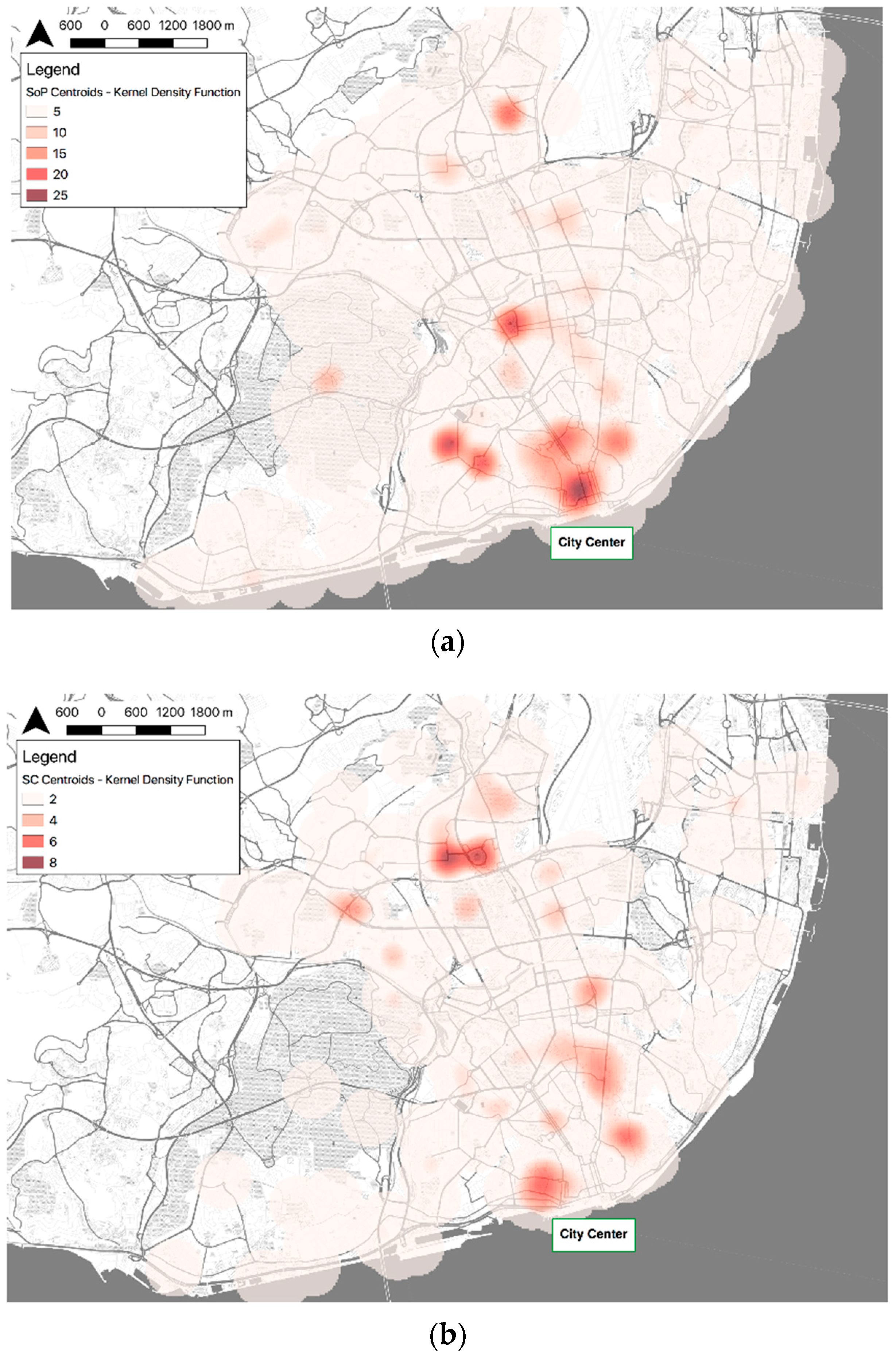
Studied participants (n = 163) defined areas of SoP and SC throughout the city of Lisbon. Collectively, all of the polygons of each type were combined, and we counted the number of overlapping between them. The maximum number of overlapping polygons for SoP was 83, while in the case of SC, the number was 45. Figure 3 shows the fuzzy or vague boundaries of these overlapped areas after applying a Kernel density function.
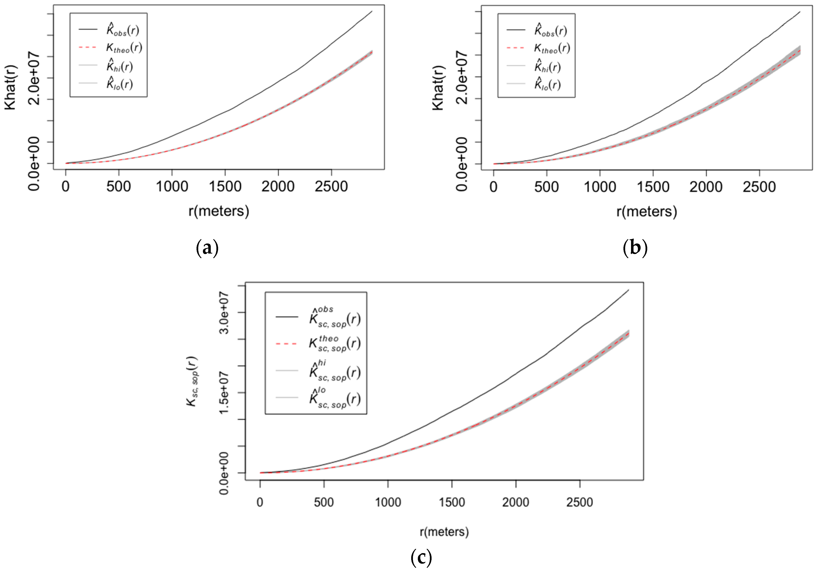
From visual inspection, the spatial overlapping of both SoP and SC is mainly geographically situated in the city center of Lisbon (south), with clearly more intensity in the case of SoP. Indeed, the overlapping SoP areas are mainly in the city center. Conversely, concurrence areas (overlap) of where SC is concentrated are rather situated in the surroundings of the city center. To study the distribution of SoP and SC, and their possible spatial clustering in the city of Lisbon, we calculated the Kernel density function, their univariate spatial behavior, and the bivariate spatial pattern between both. Figure 4 shows the distribution of the centroids for both. While the GSoP are more located around the city center, the GSC areas are more dispersed around the city. To analyze the spatial distribution of each pattern (SoP and SC), we performed two statistical point pattern analyses. Figure 5 shows the plots of Ripley’s K function of each and the cross-type Ripley’s function. The x-axis describes the different geographical scales in which the analysis was performed in meters, while the y-axis represents the estimated value for Ripley’s K function and the cross-type Ripley’s function, respectively. We identified that both series of events (SoP and SC) exhibit spatial clustering in all of the scales. The bivariate spatial analysis for testing the hypothesis of non-spatial interaction between them (a cross-type Ripley’s function) also shows a schema of spatial aggregation at all of the scales.
3.2. Individual Level: Sharp Understanding of Place Urban Dynamics
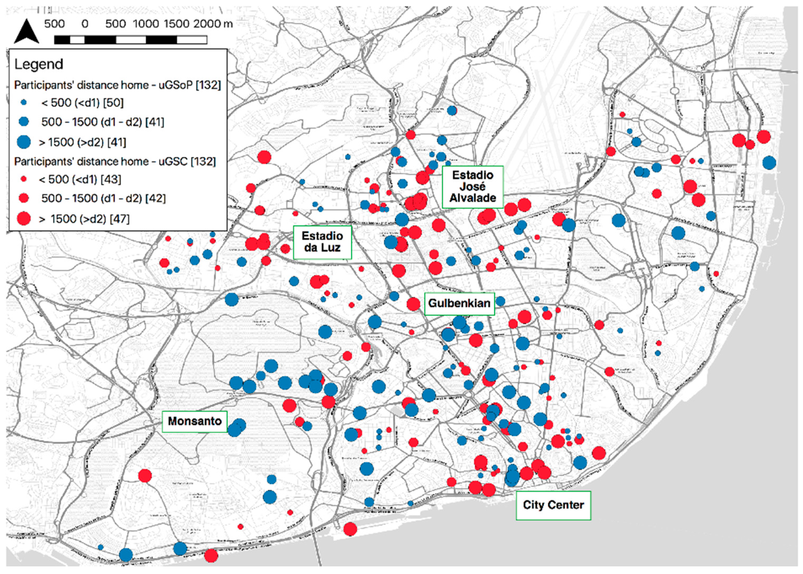
We can discern between two groups of participants: those whose spatial relationship between uGSoP and uGSC was non-disjoint (n = 87), and those who exhibited a disjoint relationship (n = 76). At the individual level, we performed two analyses: closeness and localness. The study of closeness relates the minimum Euclidean distance between home and both areas (SoP and SC) based on the thresholds defined in Section 2.2.2. Figure 6 presents several SoP and SC hotspots in certain zones: besides the city center, the Gulbenkian Foundation and the area surrounding José Alvalade Stadium. The former is an environmentally cultural place, while the latter is a football stadium. Both hold citizens’ personal attachments and meaningful social relations. For the relation between home and uGSC, the largest number of participants falls in the largest threshold (35%, large red circle), followed by the shortest threshold (33%, small red circle) and the threshold between d1 and d2 (32%, medium red circle), respectively. The similarity in the classification denotes that further investigations are needed to differentiate participants better. Regarding uGSoP, the shortest threshold is slightly higher (38%, smallest blue circle), the remaining groups (d1–d2 (medium blue circle) and >d2 (large blue circle)) have the same percentage of participants (31%). Again, the similarity between the classification groups does not allow for any conclusion. This behavior in the two concepts can denote a spatial linear similarity from participants’ homes and their SoP and SC, i.e., significant places for participants (i.e., SoP) are “equally” spatially related to home as their meaningful relationships (i.e., SC). Further investigations are needed to better differentiate participants regarding the spatial relationship between their home and SoP/SC, respectively. However, there is something to say about the distribution of the areas. For instance, an important number of large blue points (SoP area > d2 (1500 m)) are located in the zone of Monsanto park. This is a big park (around 1000 ha) that is situated in the southwest of Lisbon city. Participants obviously don’t live in the park, but, based on the map, they have an attachment toward this green zone. Another interesting appreciation is the cluster of both the smallest blue and red points in the second ring of the city (between the Gulbenkian and Estadio Jose Alvalade labels). Participants that live in this zone also have some of their social relationships and attachment close to home.
For the study of participants’ localness regarding their areas of uGSoP and uGSC, we use the spatial boundaries of parishes to distinguish between citizens that have all of the GSOP and GSC areas inside a parish and those that do not (Table 2). Furthermore, we differentiate between the home parish and the other parishes. Lisbon is structured into 24 parishes, which all possess administrative power.
It is important to highlight the attachment toward the home parish in this study. Only 12% of participants defined all of the GSoP outside of their home parish. In contrast, participants indicated that the uGSC is more spread: 37% was within and 33% was outside of the home parish, and the rest had both within and outside the home parish (30%). However, it is relevant to underline that approximately 56% of participants identified their GSC areas inside the same parish. This means that more than half of the participants belong to social groups in a single parish, which denotes the localness of their social relations. When we combine both sets of areas (uGSoP and uGSC), only 21% of the participants identify them in the same parish.
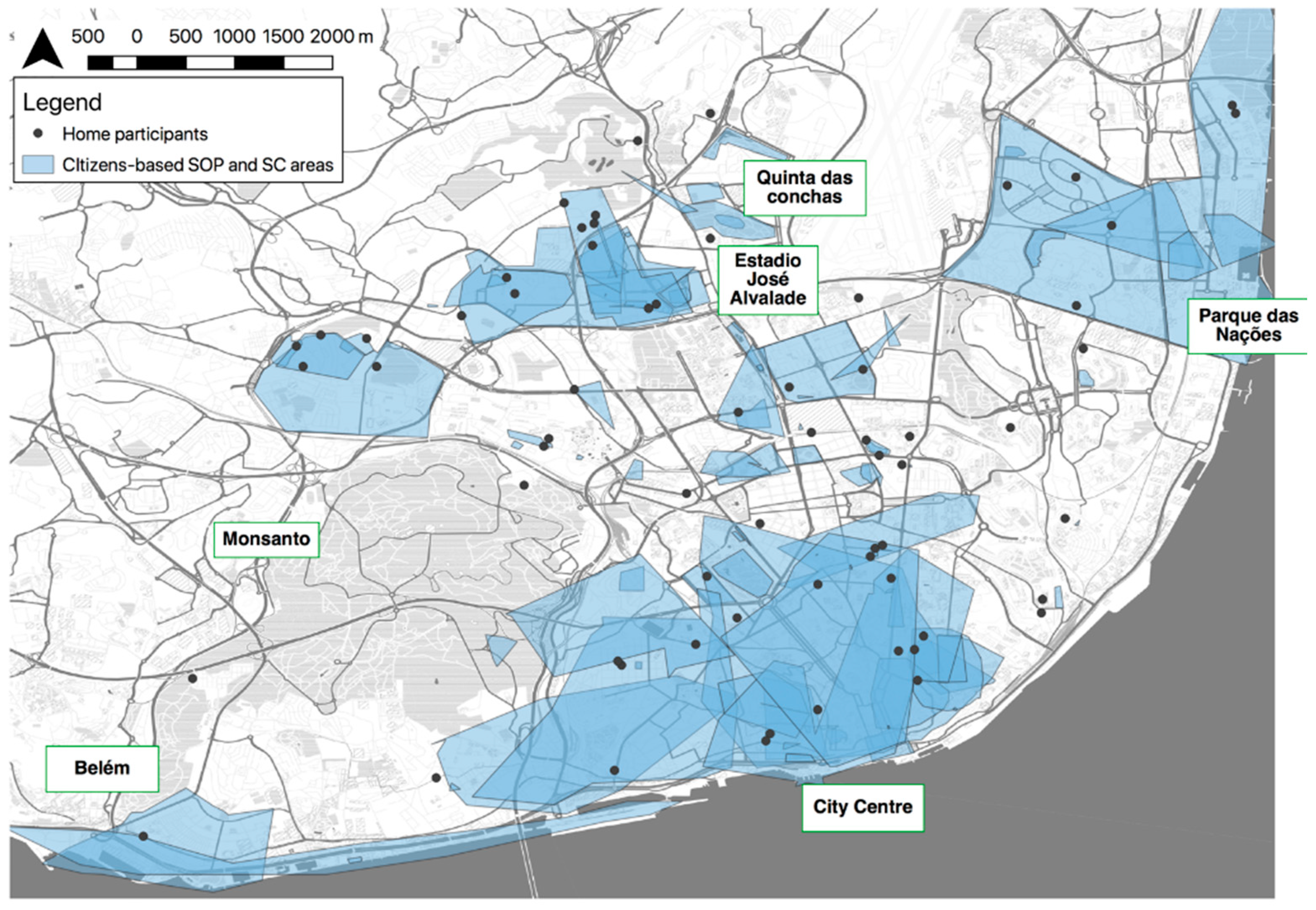
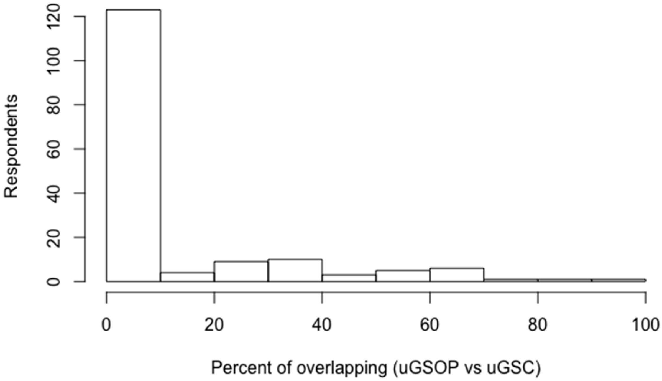
Participants with a non-disjoint sharp spatial relationship between uGSoP and uGSC mainly have this concurrency in the city center (see Figure 7). There are also intersected areas in Belém and Parque das Nações. Those areas represent historical (Belém) and recent symbolic places (Parque das Nações) where citizens experience a SoP, and according to the results, they also encounter their social networks (SC). In turn, there are small isolated areas in the second ring of the city and several citizen-based areas based on SoP and SC in the surroundings of the football stadium (José Alvalade Stadium) and other outskirt zones (see Figure 7). The percentages shown in Figure 8 correspond to the area of overlapping with respect to the union of corresponding uGSoP and uGSC. About 25% of the participants hold more than 10% overlap between their non-disjoint uGSoP and uGSC. Furthermore, we also studied the kind of spatial relationship. From the total non-disjoint relationships (87), six participants defined their uGSoP within their uGSC, and 13 participants defined the relationship the other way around. The remaining participants (68) followed an overlap topological relationship.
4. Discussion
We can understand any city as a landmark connected in a dynamic and functional global network. Likewise, at the city level, the same structure is repeated based on the local perspective; dynamic and functional network of places. The current challenge within the city context is to understand the citizens’ spatialities that shape this platial reasoning. Currently, we confront a dichotomy between understanding (1) citizens as beings within a pre-established range (e.g., neighborhoods and parishes), with difficulties when dealing with social problems due to objective administrative boundary delimitation [90,91] and (2) citizens as individually-based ranges established on daily interactions, feelings, and social interactions (i.e., individual spatialities). Our research focuses on the second conceptualization by providing a better command of the urban intelligence notion through the operationalization of citizen’s significant areas (GSoP) and meaningful social relations (GSC).
We found notable spatial variability in the direct mapping of SoP and SC using PPGIS methods. We expected this finding since, for instance, SoP can encompass a wide range of spatial scales, (from an armchair to the whole earth [11]). However, in this study, participants defined their areas of SoP and SC “locally”; only one area exceeds 25 km2 (1/4 of Lisbon city area). The methodology followed in this study shapes the interpretation of place dynamics from two different perspectives: fuzzy and sharp. This dual approach allows the study of place dynamics through fuzzy or vague boundaries at the city level and attempts to elucidate the individual-place based areas by sharp boundaries at the individual level. Although the spatial data is the same for both perspectives, the combination of the three different analyses that were used provides a better comprehension of the platial urban dynamics based on SoP and SC at both levels (i.e., individual and collective):
- At the collective level, GSoP exhibits more spatial concurrence (overlap) than GSC, since participants defined more GSoP than GSC. In turn, the spatial point pattern analysis of the GSoP and GSC centroids that was performed shows that both the univariate and bivariate analysis have a spatial clustering in all of the scales. This means that it is very likely that an area of SoP occurs close to other areas of the same type. This statement is also true for SC and for the analyses of both together (bivariate analyses). Thus, the aggregated areas of SoP and SC within Lisbon show similarly located spatial distributions (see Figure 4) and are spatially clustered in all of the studied scales. Based on our study case, GSoP has more intensity in the city center, and GSC is more spread along the city.
- At the individual level, closeness was calculated based on the linear spatial relationship between home and the two studied concepts (SoP and SC). We did not obtain any significant dissimilarity between the groups formed based on d1 and d2. This finding can be related to the spatial autocorrelation (spatial clustering) that we found at the collective level for all of the concepts in all of the scales. Concurrently, a strong influence of participants’ home location over their SoP and SC areas is also shown. Closeness analysis also discloses that green zones and parks are areas of strong attachment, although they are not close to home (>d2). Localness was calculated with the addition of parish boundaries to the study. Results show that (1) the meaningful social relationships of participants are locally situated: more than half of the participants belong to social groups in a single parish; (2) participants are attached toward part or parts of their home parish as it was already pointed out in Lewicka’s [29] study.
Our presupposition that uGSoP and uGSC follow an important non-disjoint spatial relationship at the individual level (based on Acedo et al. [42]) was generally supported by the results of this study. All of the participants’ areas for each type (SoP and SC) almost entirely cover Lisbon; thus, the concurrence areas at the aggregated level follow the same spatial behavior. At the individual level, the non-disjoint spatial relationship between uGSoP and uGSC was about 53% (see Figure 8), although it is important to highlight that this percentage is influenced by the method for defining both bounding areas (uGSOP and uGSC). Our method to generate both areas uses the Union GISc technique (http://desktop.arcgis.com/en/arcmap/10.3/tools/analysis-toolbox/union.htm [accessed on 26 June]), while other similar studies used methods such as minimum convex polygon (MCP) [38,82] to determine place attachment and neighborhood home range, respectively. The comparison between the two techniques can hide a higher spatial concurrence by the latter. Concurrently, the use of MCP also can imply the aggregation of insignificant places for an individual in the computational process. Having said that, we speculate that our approach achieves a better spatial accuracy on citizens’ spatialities and grants an extra value to our non-disjoint spatial relationship percentage between uGSoP and uGSC (53%). This percentage is in consonance with (1) some authors that systematically demonstrate that SC in the form of local contacts (neighbors, family, friends living nearby) are a consistent predictor of place attachment (SoP’s dimension [34]) [92]; (2) others include social contacts as a separate dimension of place attachment [49] or (3) as a prominence element that explains part of the place dimension of place attachment [93]. However, although some authors have argued that ‘the social capital rarely appears in literature dealing with place attachment’ [29], the spatial pattern SoP’s and SC’s imprint in the city has not been studied and validated to date.
Some researchers have identified the need for new boundaries that recognize the city interactions based on a socio-geographic approach for social issues [91]. Our exploratory study goes further, as it deals with the notion of urban intelligence, which is mainly dependent on our capability to understand platial urban dynamics. Hence, we are not just trying to rethink the current administrative boundaries, we are also trying to understand the city from another perspective, as other authors have already highlighted [1,36,94], namely by studying the network that embeds the platial urban dynamics of the city. While there has been considerable academic writing on place network dynamics, its practical application beyond the hypothetical has been minimal. In part, the spatialization of place, or related complex and multifaceted concepts (i.e., SoP and SC), entails a difficulty of reducing them to geographic primitives [37] because they are the product of social interaction processes [36]. We are aware of this constraint, as well as alternative “vague” methods in other studies [37]. However, we attempt to spatialize SoP and SC through a PPGIS application based on the definition of polygons. We do not deny the social dynamism of the studied concepts, but we required “a spatial picture” of them in a given time (12 June to 2 July 2017 for this study) in order to evaluate their sharp and fuzzy spatial relationships. We are dealing with dynamic, time-dependent, and scale variable concepts. Citizens’ spatialities that embed SoP and SC may change over an individuals’ lifetime, highlighting the requisite for longitudinal time-series studies and a dynamic collection of social data. The authors of this study acknowledge this point as a limitation of this kind of study and methodology.
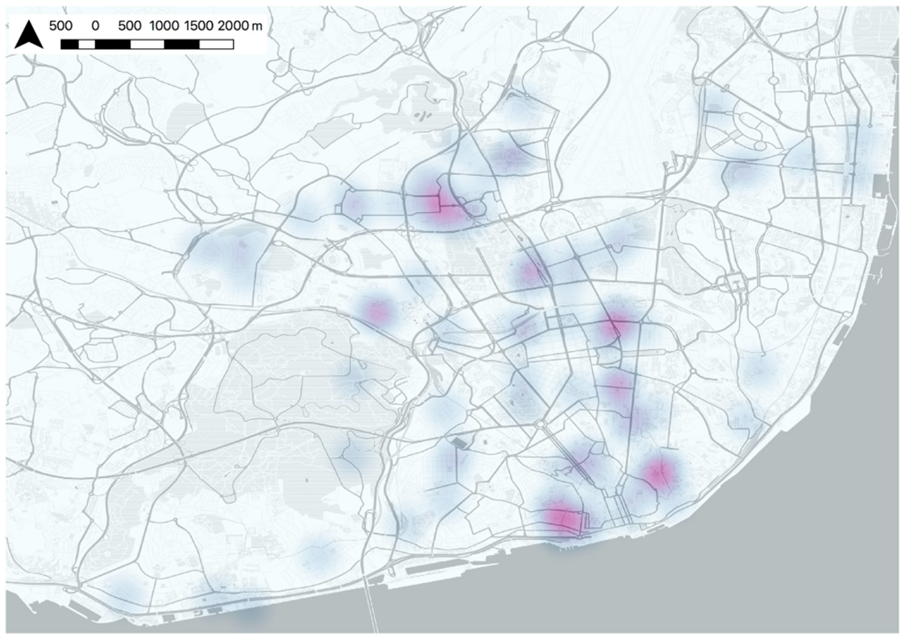
We elucidate throughout the paper that mapping SoP and SC and analyzing their spatial relationship illustrates an alternative for the operationalization of place, urban dynamics, and urban intelligence. The definition of place as a situated social process implies the continuous redefinition based on the social relations of individuals (SC in this study) and the individual–space interaction (SoP in this study) in space and time [95]. The theoretical conceptualization and alignment of a network based on the structure of place has been extensively studied [1,36,94]; however, to the best of our knowledge, this is the first exploratory study to partly try to visualize the spatial definition of the imprint of that urban intelligence. Hence, there were few clues to guide the methodology of this article. As a consequence, we analyze the collected areas through three analyses relating the collective (fuzzy boundaries) and individual (sharp boundaries) levels. Based on that, we achieve a sharp participants-based area that embeds SoP and SC spatial dimension at the individual level (Figure 7). All of the areas depicted in Figure 7 harmonize the participants’ network of places that are defined by important places and fruitful relationships. However, as was mentioned above, the identification of place with geographical primitives when place nature follows a dynamic social process is not the most suitable representation. Figure 9 shows the Kernel density function of Figure 7 (based on centroids), which can be understood as the fuzzy representation of those participants-based areas that embed SoP and SC.
We speculate that those fuzzy or vague areas (Figure 9) have potential similarities with the notion of place established by Agnew [16,20] for each involved participant. He defines three dimensions of place: SoP, locale, and location. The latter is implicitly the spatial dimension where place exists, that is, where the other two appear. Locale refers to the settings where daily activities occur [16], i.e., the geo-sociological element of place. Those locales can be workplaces, homes, and shopping malls [16]. From this perspective, our SC conceptualization (values of social relationships and networks to societies and individuals) can share elements with locale. Furthermore, the significantly narrow spatial relationship between SoP and SC (argued in this article) emphasizes and accommodates the idea of treating SC and locale as similar concepts, which presents a potential topic for future research. Therefore, the spatial alignment of Figure 8 attempts to partially represent the platial dynamics for an urban intelligence based on individuals’ spatialities of SoP and SC in a given time. Those vague locations form a platial system throughout the city in accordance with the city’ conceptualization as a dynamic network of connected urban places [1,94] instead of a continuous and homogeneous space.
5. Conclusions and Future Work
We foresee a big potential of spatially defining the city’s urban platial dynamics in different areas of knowledge such as planning. However, this exploratory study is just a first step of a long way to go in the meaningful operationalization of the urban intelligence on a map. Until this process is normalized and dynamically updated, it will not be able to influence other areas of knowledge such as land-use planning and decision support. Therefore, this study aims to open up the agenda for further research into exploratory place-based geography studies. Currently, there is an optimal environment within the smart city realm to “digitalize” our spatialities for achieving a more understandable city. Fortunately, the abyss between digital technology, social science, and digital data is becoming smaller. If they finally coalesce, the concept of place will clearly occupy a central position [25]. Having said that, this study has proved the significant non-disjoint spatial relationship between SoP and SC spatial dimensions at the individual level and a schema of spatial clustering at the collective level. We also reasoned about the suitability of understanding SoP and SC as inhibitors of place-making and their spatialization as an alternative way to elucidate the platial urban dynamics in the city toward urban intelligence. Future work will be in the line of better understanding the nature of those places that form the platial urban dynamic network and comprehending the interrelation between them. This last point is only possible with the perspective based on a collective platial network, i.e., not just to add individual-based areas to the network, but also understand the synergies between the collective to create potential environments for cooperation, participation, and collaboration at the community level. This is only possible with the connection of these unique individual-based places with a commonplace that represents each individual, and in turn, it does not lose its shared nature to become new arenas of contact for all of the stakeholders of the smart city.
Author Contributions
Conceptualization, A.A., S.R. and M.P.; Data curation, A.A.; Formal analysis, A.A.; Funding acquisition, M.P.; Investigation, A.A.; Methodology, A.A.; Project administration, M.P.; Resources, M.P.; Software, A.A.; Visualization, A.A.; Writing—original draft, A.A.; Writing—review and editing, M.P. and S.C.
Funding
This research was funded by the European Comission through the GEO-C project (H2020-MSCA-ITN-2014, grant number 642332) and Sven Casteleyn is funded by the Ramón y Cajal Programme of the Spanish government, Grant No. RYC-2014-16606.
Acknowledgments
The authors acknowledge the collaboration with the Câmara Municipal de Lisboa in facilitating the application of the online survey.
Conflicts of Interest
The authors declare no conflict of interest.
Appendix A

Table A1.
Questions from the web map-based survey to present sense of place and social capital for their spatialization.
Table A1.
Questions from the web map-based survey to present sense of place and social capital for their spatialization.
| Concept | Question | Adapted from |
|---|---|---|
| Sense of place (SoP) | We want to know where are the areas that, for some reason/s, are significant for you. Please, think about the area/s which you: identify the most with (e.g., this place represents me) and/or feel attached to (e.g., I love this place) and/or depend on (e.g., it is the most suitable place for doing the things that I enjoy the most) | [34] |
| Social Capital (SC) | We would also like to ask you about the groups of people or organizations, networks, associations to which you belong. These could be formally organized groups (religious groups, familiar groups, sports teams, workplace groups…) or just groups of people who get together regularly to do an activity or talk about things. | [77] |
References
- Roche, S. Geographic Information Science II. Prog. Hum. Geogr. 2016, 40, 565–573. [Google Scholar] [CrossRef]
- Warf, B.; Sui, D. From GIS to Neogeography: Ontological Implications and Theories of Truth. Ann. GIS 2010, 16, 197–209. [Google Scholar] [CrossRef]
- Goodchild, M.F. Citizens as Sensors: The World of Volunteered Geography. GeoJournal 2007, 69, 211–221. [Google Scholar] [CrossRef]
- Kyttä, M.; Kahila, M. SoftGIS Methodology—Building Bridges in Urban Planning; GIM International (The Global Magazine Geomatics): Lemmer, The Netherlands, 2011; Volume 25. [Google Scholar]
- Rantanen, H.; Kahila, M. The SoftGIS Approach to Local Knowledge. J. Environ. Manag. 2009, 90, 1981–1990. [Google Scholar] [CrossRef] [PubMed]
- Calzada, I.; Cobo, C. Unplugging: Deconstructing the Smart City. J. Urban Technol. 2015, 22, 23–43. [Google Scholar] [CrossRef]
- Lussault, M. L’Homme Spatial. La Construction Sociale de l’espace Humain: La Construction Sociale de l’espace Humain; Le Seuil: Paris, France, 2007. [Google Scholar]
- Elwood, S.; Goodchild, M.F.; Sui, D.Z. Researching Volunteered Geographic Information: Spatial Data, Geographic Research, and New Social Practice. Ann. Assoc. Am. Geogr. 2012, 102, 571–590. [Google Scholar] [CrossRef]
- Westlund, H.; Rutten, R.; Boekema, F. Social Capital, Distance, Borders and Levels of Space: Conclusions and Further Issues. Eur. Plan. Stud. 2010, 18, 965–970. [Google Scholar] [CrossRef]
- Goodchild, M.F. Formalizing Place in Geographic Information Systems. In Communities, Neighborhoods, and Health; Burton, L.M., Matthews, S.A., Leung, M., Kemp, S.P., Takeuchi, T.D., Eds.; Springer: New York, NY, USA, 2011; pp. 21–33. [Google Scholar]
- Tuan, Y.-F. Space and Place: The Perspective of Experience; University of Minnesota Press: Minneapolis, MN, USA, 1978; Volume 7. [Google Scholar]
- Relph, E. Place and Placelessness; Pion Ltd.: London, UK, 1976; Volume 67. [Google Scholar]
- Papadakis, E.; Resch, B.; Blaschke, T. A Function-Based Model of Place. GIScience 2016, 1, 248–251. [Google Scholar] [CrossRef]
- Norberg-Schulz, C. Genius Loci: Towards a Phenomenology of Architecture; Rizzoli International Publishers: New York, NY, USA, 1980. [Google Scholar]
- Gieryn, T.F. A Space for Place in Sociology. Annu. Rev. Sociol. 2000, 26, 463–496. [Google Scholar] [CrossRef]
- Agnew, J.A. Space and Place. In Handbook of Geographical Knowledge; Livingstone, D.N., Agnew, J.A., Eds.; SAGE Publications: London, UK, 2011; Volume 2011, pp. 316–330. [Google Scholar]
- Cresswell, T. Place. In International Encyclopedia of Human Geography; Thrift, N., Kitchin, R., Eds.; Wiley-Blackwell: Oxford, UK, 2009; pp. 169–177. [Google Scholar]
- Stokols, D.; Shumaker, S.A. People in Places: A Transactional View of Settings. In Cognition, Social Behavior, and the Environment; Lawrence Erlbaum Associates: Mahwah, NJ, USA, 1981; pp. 441–488. [Google Scholar]
- Canter, D. The Psychology of Place; Architectural Press: London, UK, 1977. [Google Scholar]
- Agnew, J.A. Place and Politics in Modern Italy; University of Chicago Press: Chicago, IL, USA, 2002. [Google Scholar]
- Williams, D.R. Making Sense of ‘Place’: Reflections on Pluralism and Positionality in Place Research. Landsc. Urban Plan. 2014, 131, 74–82. [Google Scholar] [CrossRef]
- Winter, S.; Freksa, C. Approaching the Notion of Place by Contrast. J. Spat. Inf. Sci. 2012, 5, 31–50. [Google Scholar] [CrossRef]
- Jones, C.B.; Purves, R.S.; Clough, P.D.; Joho, H. Modelling Vague Places with Knowledge from the Web. Int. J. Geogr. Inf. Sci. 2008, 22, 1045–1065. [Google Scholar] [CrossRef] [Green Version]
- Cresswell, T. (Ed.) Place a Short Introduction; Blackwell Publishing: Victoria, Australia, 2004; Volume 58. [Google Scholar]
- Goodchild, M.F.; Li, L. Formalizing Space and Place. In Proceedings of the Colloque Fondateur du CIST (CIST2011)—Fonder les Sciences du Territoire, Paris, France, 23–25 November 2011; pp. 177–183. [Google Scholar]
- See, L.; Mooney, P.; Foody, G.; Bastin, L.; Comber, A.; Estima, J.; Fritz, S.; Kerle, N.; Jiang, B.; Laakso, M.; et al. Crowdsourcing, Citizen Science or Volunteered Geographic Information? The Current State of Crowdsourced Geographic Information. ISPRS Int. J. Geo-Inf. 2016, 5, 55. [Google Scholar] [CrossRef]
- Quesnot, T.; Roche, S. Measure of Landmark Semantic Salience through Geosocial Data Streams. ISPRS Int. J. Geo-Inf. 2014, 4, 1–31. [Google Scholar] [CrossRef] [Green Version]
- Sui, D.; Goodchild, M. The Convergence of GIS and Social Media: Challenges for GIScience. Int. J. Geogr. Inf. Sci. 2011, 25, 1737–1748. [Google Scholar] [CrossRef]
- Lewicka, M. Place Attachment: How Far Have We Come in the Last 40 Years? J. Environ. Psychol. 2011, 31, 207–230. [Google Scholar] [CrossRef]
- Hidalgo, M.C.; Hernández, B. Place Attachment: Conceptual and Empirical Questions. J. Environ. Psychol. 2001, 21, 273–281. [Google Scholar] [CrossRef]
- Lowery, D.R.; Morse, W.C. A Qualitative Method for Collecting Spatial Data on Important Places for Recreation, Livelihoods, and Ecological Meanings: Integrating Focus Groups with Public Participation Geographic Information Systems. Soc. Nat. Resour. 2013, 26, 1422–1437. [Google Scholar] [CrossRef]
- Jorgensen, B.S.; Stedman, R.C. Measuring the Spatial Component of Sense of Place: A Methodology for Research on the Spatial Dynamics of Psychological Experiences of Places. Environ. Plan. B Plan. Des. 2011, 38, 795–813. [Google Scholar] [CrossRef]
- Hay, R. Sense of Place in Development Context. J. Environ. Psychol. 1998, 18, 5–29. [Google Scholar] [CrossRef]
- Jorgensen, B.S.; Stedman, R.C. Sense of Place as an Attitude: Lakeshore Owners Attitudes toward Their Properties. J. Environ. Psychol. 2001, 21, 233–248. [Google Scholar] [CrossRef]
- Elwood, S. Critical Issues in Participatory GIS: Deconstructions, Reconstructions, and New Research Directions. Trans. GIS 2006, 10, 693–708. [Google Scholar] [CrossRef]
- Massey, D. Space, Place, and Gender; University of Minnesota Press: Minneapolis, MN, USA, 1994. [Google Scholar]
- Huck, J.J.; Whyatt, J.D.; Coulton, P. Spraycan: A PPGIS for Capturing Imprecise Notions of Place. Appl. Geogr. 2014, 55, 229–237. [Google Scholar] [CrossRef]
- Brown, G.; Raymond, C.M.; Corcoran, J. Mapping and Measuring Place Attachment. Appl. Geogr. 2015, 57, 42–53. [Google Scholar] [CrossRef]
- Coulton, C.J.; Korbin, J.; Chan, T.; Su, M. Mapping Residents’ Perceptions of Neighborhood Boundaries: A Methodological Note. Am. J. Community Psychol. 2001, 29, 371–383. [Google Scholar] [CrossRef] [PubMed]
- Montello, D.R.; Goodchild, M.F.; Gottsegen, J.; Fohl, P. Where’s Downtown?: Behavioral Methods for Determining Referents of Vague Spatial Queries. Spat. Cogn. Comput. 2003, 3, 185–204. [Google Scholar] [CrossRef]
- Waters, T.; Evans, A.J. Tools for Web-Based GIS Mapping of a “Fuzzy” Vernacular Geography. In Proceedings of the 7th International Conference on GeoComputation, Southampton, UK, 8–10 September 2003; Available online: http://www.geog.leeds.ac.uk/people/a.evans/publicinfo.html (accessed on 17 July 2018).
- Acedo, A.; Painho, M.; Casteleyn, S. Place and City: Operationalizing Sense of Place and Social Capital in the Urban Context. Trans. GIS 2017, 21, 503–520. [Google Scholar] [CrossRef]
- Vanclay, F. Place Matters. In Making Sense of Place: Exploring Concepts and Expressions of Place through Different Senses and Lenses; Vanclay, F., Matthew, H., Blackshaw, A., Eds.; National Museum of Australia Press: Canberra, Australia, 2008; pp. 3–11. [Google Scholar]
- Beidler, K.J.; Morrison, J.M. Sense of Place: Inquiry and Application. J. Urban 2016, 9, 205–215. [Google Scholar] [CrossRef]
- Low, S.M.; Altman, I. Place Attachment: A Conceptual Inquiry. In Place Attachment; Altman, I., Low, S.M., Eds.; Plenum Press: New York, NY, USA, 1992; pp. 1–12. [Google Scholar]
- Stedman, R.C. Is It Really Just a Social Construction?: The Contribution of the Physical Environment to Sense of Place. Soc. Nat. Resour. 2003, 16, 671–685. [Google Scholar] [CrossRef]
- Brown, G.; Raymond, C.M. The Relationship between Place Attachment and Landscape Values: Toward Mapping Place Attachment. Appl. Geogr. 2007, 27, 89–111. [Google Scholar] [CrossRef]
- Raymond, C.M.; Brown, G. A Spatial Method for Assessing Resident and Visitor Attitudes Towards Tourism Growth and Development. J. Sustain. Tour. 2007, 15, 520–540. [Google Scholar] [CrossRef]
- Raymond, C.M.; Brown, G.; Weber, D. The Measurement of Place Attachment: Personal, Community, and Environmental Connections. J. Environ. Psychol. 2010, 30, 422–434. [Google Scholar] [CrossRef]
- Powell, R.A.; Mitchell, M.S. What Is a Home Range? J. Mammal. 2012, 93, 948–958. [Google Scholar] [CrossRef]
- Jenkins, A.; Croitoru, A.; Crooks, A.T.; Stefanidis, A. Crowdsourcing a Collective Sense of Place. PLoS ONE 2016, 11, 1–20. [Google Scholar] [CrossRef] [PubMed]
- Ajzen, I.; Fishbein, M. Attitude-Behavior Relations: A Theoretical Analysis and Review of Empirical Research. Psychol. Bull. 1975, 84, 888–918. [Google Scholar] [CrossRef]
- Pretty, G.H.; Chipuer, H.M.; Bramston, P. Sense of Place amongst Adolescents and Adults in Two Rural Australian Towns: The Discriminating Features of Place Attachment, Sense of Community and Place Dependence in Relation to Place Identity. J. Environ. Psychol. 2003, 23, 273–287. [Google Scholar] [CrossRef]
- Lewicka, M. Place Inherited or Place Discovered? Agency and Communion in People-Place Bonding. Estud. Psicol. 2013, 34, 261–274. [Google Scholar] [CrossRef]
- Manzo, L.C. For Better or Worse: Exploring Multiple Dimensions of Place Meaning. J. Environ. Psychol. 2005, 25, 67–86. [Google Scholar] [CrossRef]
- Altman, I.; Low, S.M. (Eds.) Place Attachment; Plenum Press: New York, NY, USA, 1992. [Google Scholar]
- Trentelman, C.K. Place Attachment and Community Attachment: A Primer Grounded in the Lived Experience of a Community Sociologist. Soc. Nat. Resour. 2009, 22, 191–210. [Google Scholar] [CrossRef]
- Holt, L. Embodied Social Capital and Geographic Perspectives: Performing the Habitus. Prog. Hum. Geogr. 2008, 32, 227–246. [Google Scholar] [CrossRef]
- Bourdieu, P. Distinction: A Social Critique of the Judgement of Taste; Harvard University Press: Cambridge, MA, USA, 1984. [Google Scholar]
- Bourdieu, P.; Wacquant, L.J.D. The Practice of Reflexive Sociology; University of Chicago press: Chicago, IL, USA, 1992. [Google Scholar]
- Coleman, J.S. Social Capital in the Creation of Human Capital. Am. J. Sociol. 1988, 94, 95–120. [Google Scholar] [CrossRef]
- Westlund, H. Social Capital in the Knowledge Economy: Theory and Empirics; Fischer, M.M., Geoffrey, H.J.D., Nijkamp, P., Eds.; Springer Science & Business Media: Berlin/Heidelberg, Germany, 2006. [Google Scholar]
- Szreter, S. A New Political Economy for New Labour: The Importance of Social Capital; Political Economy Research Centre, University of Sheffield: Sheffield, UK, 1998. [Google Scholar]
- Perkins, D.D.; Hughey, J.; Speer, P.W. Community Psychology Perspectives on Social Capital Theory and Community Development Practice. J. Community Dev. Soc. 2002, 33, 33–52. [Google Scholar] [CrossRef]
- Radcliffe, S.A. Geography of Development: Development, Civil Society and Inequality—Social Capital Is (Almost) Dead? Prog. Hum. Geogr. 2004, 28, 517–527. [Google Scholar] [CrossRef]
- Putnam, R.D. Bowling Alone: The Collapse and Revival of American Community; Simon and Schuster: New York, NY, USA, 2000; Volume 747. [Google Scholar]
- Rutten, R.; Westlund, H.; Boekema, F. The Spatial Dimension of Social Capital. Eur. Plan. Stud. 2010, 18, 863–871. [Google Scholar] [CrossRef] [Green Version]
- Foster, K.A.; Pitner, R.; Freedman, D.A.; Bell, B.A.; Shaw, T.C. Spatial Dimensions of Social Capital. City Community 2015, 14, 392–409. [Google Scholar] [CrossRef]
- Andris, C. Integrating Social Network Data into GISystems. Int. J. Geogr. Inf. Sci. 2016, 8816, 1–23. [Google Scholar] [CrossRef]
- Valenzuela, S.; Park, N.; Kee, K.F. Is There Social Capital in a Social Network Site?: Facebook Use and College Student’s Life Satisfaction, Trust, and Participation. J. Comput. Commun. 2009, 14, 875–901. [Google Scholar] [CrossRef]
- Acedo, A.; Mendoza, G.; Painho, M.; Casteleyn, S. One Tool to Spatialize All: Sense of Place, Social Capital and Civic Engagement. In Societal Geo-Innovation: Short Papers, Posters and Poster Abstracts of the 20th AGILE Conference on Geographic Information Science; Bregt, A., Sarjakoski, T., Lammeren, R., Rip, F., Eds.; Wageningen University & Research: Wageningen, The Netherlands, 2017. [Google Scholar]
- Kahila, M.; Kyttä, M. SoftGIS as a Bridge-Builder in Collaborative Urban Planning. In Planning Support Systems Best Practice and New Methods; Geertman, S., Stillwell, J., Eds.; Springer: Dordrecht, The Netherlands, 2009; pp. 389–411. [Google Scholar]
- Sieber, R. Public Participation Geographic Information Systems: A Literature Review and Framework. Ann. Assoc. Am. Geogr. 2006, 96, 491–507. [Google Scholar] [CrossRef] [Green Version]
- Jankowski, P.; Czepkiewicz, M.; Młodkowski, M.; Zwoliński, Z. Geo-Questionnaire: A Method and Tool for Public Preference Elicitation in Land Use Planning. Trans. GIS 2016, 20, 903–924. [Google Scholar] [CrossRef]
- Brown, G.; Kyttä, M. Key Issues and Research Priorities for Public Participation GIS (PPGIS): A Synthesis Based on Empirical Research. Appl. Geogr. 2014, 46, 122–136. [Google Scholar] [CrossRef]
- Brown, G.G.; Pullar, D.V. An Evaluation of the Use of Points versus Polygons in Public Participation Geographic Information Systems Using Quasi-Experimental Design and Monte Carlo Simulation. Int. J. Geogr. Inf. Sci. 2012, 26, 231–246. [Google Scholar] [CrossRef]
- Grootaert, C.; Narayan, D.; Jones, V.N.; Woolcock, M. Measuring Social Capital: An Integrated Questionnaire; The World Bank: Washington, DC, USA, 2004. [Google Scholar]
- Diggle, P.J. Statistical Analysis of Spatial and Spatio-Temporal Point Patterns; CRC Press: Boca Raton, FL, USA, 2013. [Google Scholar]
- Baddeley, A.; Rubak, E.; Turner, R. Spatial Point Patterns: Methodology and Applications with R; CRC Press: Boca Raton, FL, USA, 2015. [Google Scholar]
- Batty, M.; Axhausen, K.; Fosca, G.; Pozdnoukhov, A.; Bazzani, A.; Wachowicz, M.; Ouzounis, G.; Portugali, Y. Smart Cities of the Future. Eur. Phys. J. Spec. Top. 2012, 214, 481–518. [Google Scholar] [CrossRef]
- De Smith, M.J.; Goodchild, M.F.; Longley, P.A. Geospatial Analysis: A Comprehensive Guide to Principles, Techniques and Software Tools; Troubador Publishing Ltd.: Winchelsea, UK, 2009. [Google Scholar]
- Hasanzadeh, K.; Broberg, A.; Kyttä, M. Where Is My Neighborhood? A Dynamic Individual-Based Definition of Home Ranges and Implementation of Multiple Evaluation Criteria. Appl. Geogr. 2017, 84, 1–10. [Google Scholar] [CrossRef]
- González, M.C.; Hidalgo, C.A.; Barabási, A.L. Understanding Individual Human Mobility Patterns. Nature 2008, 453, 779–782. [Google Scholar] [CrossRef] [PubMed]
- Toole, J.L.; de Montjoye, Y.-A.; González, M.C.; Pentland, A.S. Modeling and Understanding Intrinsic Characteristics of Human Mobility. In Social Phenomena; Gonçalves, B., Perra, N., Eds.; Springer: Cham, Switzerland, 2015; pp. 15–35. [Google Scholar]
- Giannotti, F.; Pappalardo, L.; Pedreschi, D.; Wang, D. A Complexity Science Perspective on Human Mobility. In Mobility Data; Renso, C., Spaccapietra, S., Zimanyi, E., Eds.; Cambridge University Press: Cambridge, UK, 2012; pp. 297–314. [Google Scholar]
- Pirozmand, P.; Wu, G.; Jedari, B.; Xia, F. Human Mobility in Opportunistic Networks: Characteristics, Models and Prediction Methods. J. Netw. Comput. Appl. 2014, 42, 45–58. [Google Scholar] [CrossRef]
- Karamshuk, D.; Boldrini, C.; Conti, M.; Passarella, A. Human Mobility Models for Opportunistic Networks. IEEE Commun. Mag. 2011, 49, 157–165. [Google Scholar] [CrossRef]
- Egenhofer, M.J.; Clementini, E.; di Felice, P. Research Paper. Int. J. Geogr. Inf. Syst. 1994, 8, 129–142. [Google Scholar] [CrossRef]
- Etikan, I. Comparison of Convenience Sampling and Purposive Sampling. Am. J. Theor. Appl. Stat. 2016, 5, 1–4. [Google Scholar] [CrossRef]
- Lee, B.A.; Reardon, S.F.; Firebaugh, G.; Farrell, C.R.; Matthews, S.A.; O’Sullivan, D. Beyond the Census Tract: Patterns and Determinants of Racial Segregation at Multiple Geographic Scales. Am. Sociol. Rev. 2008, 73, 766–791. [Google Scholar] [CrossRef] [PubMed] [Green Version]
- Foster, K.A.; Hipp, J.A. Defining Neighborhood Boundaries for Social Measurement: Advancing Social Work Research. Soc. Work Res. 2011, 35, 25–35. [Google Scholar] [CrossRef]
- Mesch, G.S.; Manor, O. Social Ties, Environmental Perception, And Local Attachment. Environ. Behav. 1998, 30, 504–519. [Google Scholar] [CrossRef]
- Scannell, L.; Gifford, R. Defining Place Attachment: A Tripartite Organizing Framework. J. Environ. Psychol. 2010, 30, 1–10. [Google Scholar] [CrossRef]
- Castells, M. Globalisation, Networking, Urbanisation: Reflections on the Spatial Dynamics of the Information Age. Urban Stud. 2010, 47, 2737–2745. [Google Scholar] [CrossRef]
- Cristoforetti, A.; Gennai, F.; Rodeschini, G. Home Sweet Home: The Emotional Construction of Places. J. Aging Stud. 2011, 25, 225–232. [Google Scholar] [CrossRef]
Figure 1.
A relational basic schema that shows the main concepts described in the research. Continuous circles define different locations of places by each citizen in a given city. At the individual level, the sum of all of these geographical areas creates the individual spatialities for each citizen. At the collective level, the total of these places in a given city forms the platial urban dynamic of a city (discontinuous line). The awareness and operationalization of this platial urban dynamics by the city stakeholders set the urban intelligence of a given city.

Figure 2.
Lisbon parishes distribution (study area).

Figure 3.
Representation of areas of overlapping (a) sense of place (SoP) and (b) social capital (SC) using a Kernel density function.
Figure 3.
Representation of areas of overlapping (a) sense of place (SoP) and (b) social capital (SC) using a Kernel density function.

Figure 4.
Sense of place (a) and social capital (b) hotspots in Lisbon using a Kernel density function with a bandwidth = 500 m and grid cell = 30 m.
Figure 4.
Sense of place (a) and social capital (b) hotspots in Lisbon using a Kernel density function with a bandwidth = 500 m and grid cell = 30 m.

Figure 5.
Ripley’s K function for sense of place (a), social capital (b), and a cross-type Ripley’s K function (c).
Figure 5.
Ripley’s K function for sense of place (a), social capital (b), and a cross-type Ripley’s K function (c).

Figure 6.
Distribution along the city of Lisbon of participants. Notes: (1) just 132 participants wanted to accurately spatially define their home; (2) it is represented as the centroid of the areas, but the Euclidean distance is related to the closest point between participants’ homes and the targeted area.

Figure 7.
Group A: defined areas embedding the spatial dimensions of SoP and SC of participants.

Figure 8.
Frequency distribution of overlapping between sense of place and social capital areas.

Figure 9.
Fuzzy representation of participants-based area that embed SoP and SC based on Kernel density estimation function.
Figure 9.
Fuzzy representation of participants-based area that embed SoP and SC based on Kernel density estimation function.

Table 1.
Demographics of the sample for this study.
| Demographic Characteristics (n = 163) | Respondents | % |
|---|---|---|
| Age (years) | ||
| Less than 35 | 57 | 34.97 |
| Between 35–50 | 58 | 35.58 |
| More than 50 | 48 | 29.45 |
| Gender | ||
| Female | 75 | 46.01 |
| Male | 88 | 53.99 |
| Household monthly income (euros) | ||
| Less than 1000 | 14 | 8.59 |
| 1000–1499 | 27 | 16.56 |
| 1500–1999 | 28 | 17.18 |
| 2000–2999 | 41 | 25.15 |
| 3000–4999 | 14 | 8.59 |
| More than 5000 | 13 | 7.98 |
| N/A | 26 | 15.95 |
| Profession | ||
| Employed worker | 89 | 54.60 |
| Freelance | 24 | 14.72 |
| Retired | 18 | 11.04 |
| Student | 12 | 7.36 |
| Other | 12 | 7.36 |
| Unemployed | 8 | 4.91 |
Table 2.
Distribution of Geographical sense of place (GSoP) and Geographical social capital (GSC) regarding the home parish.
Table 2.
Distribution of Geographical sense of place (GSoP) and Geographical social capital (GSC) regarding the home parish.
| Areas’ Distributions | Specific Areas’ Distributions | Group A + B | ||||
|---|---|---|---|---|---|---|
| uGSoP | uGSC | GSoP | GSC | uGSoP and uGSC | ||
| All citizens’ areas within same parish | Home parish | 57 (35%) | 60 (37%) | 61 (37%) | 92 (56%) | 35 (21%) |
| Other parishes | 4 (2%) | 32 (20%) | ||||
| Citizens’ areas outside and within parishes | All areas outside home parish | 19 (12%) | 54 (33%) | 102 (63%) | 71 (44%) | 128 (79%) |
| Others | 83 (51%) | 17 (10%) | ||||
| Total citizens | Total citizens | 163 | 163 | 163 | 163 | 163 |
© 2018 by the authors. Licensee MDPI, Basel, Switzerland. This article is an open access article distributed under the terms and conditions of the Creative Commons Attribution (CC BY) license (http://creativecommons.org/licenses/by/4.0/).
Share and Cite
MDPI and ACS Style
Acedo, A.; Painho, M.; Casteleyn, S.; Roche, S. Place and City: Toward Urban Intelligence. ISPRS Int. J. Geo-Inf. 2018, 7, 346. https://doi.org/10.3390/ijgi7090346
AMA Style
Acedo A, Painho M, Casteleyn S, Roche S. Place and City: Toward Urban Intelligence. ISPRS International Journal of Geo-Information. 2018; 7(9):346. https://doi.org/10.3390/ijgi7090346
Chicago/Turabian StyleAcedo, Albert, Marco Painho, Sven Casteleyn, and Stéphane Roche. 2018. "Place and City: Toward Urban Intelligence" ISPRS International Journal of Geo-Information 7, no. 9: 346. https://doi.org/10.3390/ijgi7090346
Note that from the first issue of 2016, this journal uses article numbers instead of page numbers. See further details here.