Article

A Hydrological Sensor Web Ontology Based on the SSN Ontology: A Case Study for a Flood

State Key Laboratory of Information Engineering in Surveying, Mapping and Remote Sensing, Wuhan University, No. 129 Luoyu Road, Wuhan 430079, China
*
Author to whom correspondence should be addressed.
ISPRS Int. J. Geo-Inf. 2018, 7(1), 2; https://doi.org/10.3390/ijgi7010002
Submission received: 16 November 2017 / Revised: 14 December 2017 / Accepted: 22 December 2017 / Published: 24 December 2017

Abstract

:
Accompanying the continuous development of sensor network technology, sensors worldwide are constantly producing observation data. However, the sensors and their data from different observation platforms are sometimes difficult to use collaboratively in response to natural disasters such as floods for the lack of semantics. In this paper, a hydrological sensor web ontology based on SSN ontology is proposed to describe the heterogeneous hydrological sensor web resources by importing the time and space ontology, instantiating the hydrological classes, and establishing reasoning rules. This work has been validated by semantic querying and knowledge acquiring experiments. The results demonstrate the feasibility and effectiveness of the proposed ontology and its potential to grow into a more comprehensive ontology for hydrological monitoring collaboratively. In addition, this method of ontology modeling is generally applicable to other applications and domains.

1. Introduction

An ontology is a formal representation of a domain, composed of concepts and named relationships [1]. The ontology is a means of supporting the access to and evaluation of spatial information automatically. They are helpful when fast access to diverse observation information sources is required in emergency situations where decisions must be made rapidly [2]. Over the past decade, a core objective of applying ontology has been to integrate heterogeneous sensors effectively during periods of natural disasters [3,4,5]. Some natural disasters such as floods occur suddenly and evolve dynamically and can be monitored more effectively and efficiently by ontology technology [6].
Ontology was first applied in sensor networks in 2004 [7]. After an extensive review of related ontologies and data models, the Semantic Sensor Network Incubator Group (SSN-XG) [8] proposed the first version of the Semantic Sensor Network (SSN) ontology in 2011. In October 2017, the last version of SSN ontology was recommended by the World Wide Web Consortium (W3C) [9]. The SSN ontology can describe sensors, sensing, sensor measurement capabilities, the observations that result from sensing, and deployments. It covers large parts of the Sensor Model Language (SensorML) [10] and Observations and Measurements (O & M) [11] standards included in the Open Geospatial Consortium (OGC) Sensor Web Enablement (SWE) framework of specifications [12], omitting calibrations, process descriptions, data types, and sensor specifics [13]. The SSN ontology is a domain-independent model that has to be extended with specialized concepts and instances [14].
Studies relating to SSN ontology have been published since the early 2010s. These studies can be summarized in three research directions, as follows.
Many studies involve the implementing domain knowledge to apply SSN ontology to specific applications. For example, Llaves et al. [15] designed adapters for different data formats and distributed processing of streams in a cluster to reduce the average latency of message processing for Sensor Data Management in the Environmental Domain; Dutta and Morshed [16] proposed a domain ontology-based linked data approach to assess the reliability of the hydrological sensor network and evaluate the performance of the sensor network; Ploennigs et al. [17] extended the SSN for automating the creation and configuration of physical models to detect and diagnose abnormal building behavior; Dey et al. [18] described the organization of general sensor information and its management and particularly elaborated on the case for energy sensor using SSN ontology; Fernandez and Ito [19] used SSN ontology to manage sensor information in an intelligent transportation architecture, which performed the automatic traffic light settings allowing the prediction and avoidance of traffic accidents, and the routing optimization.
In some studies, SSN ontology is enriched with additional abilities. For instance, Calbimonte et al. [14] proposed an approach for providing data access and query capabilities to streaming data sources based on SSN ontology; Ruta et al. and Gramegna adopted the SSN-XG W3C ontology to collect and annotate data from the SSNs by extending the Constrained Application Protocol (CoAP) [20,21].
Other studies aim to share and reuse in a variety of ways. Wei and Barnaghi [22] proposed the use of the “linked data” principle to connect the sensor data to existing knowledge represented in different ontologies. Specifically, Pfisterer et al. [23] developed an ontology starting from the alignment of the already existing ontologies such as Dolce Ultralite, the SSN ontology, and Event Model F, to support cross-domain descriptions of sensor-related data and its context (higher-level events), and integrate sensors and things into the Linked Open Data (LOD) [24] cloud; Gyrard et al. [25] referred and classified semantic-based projects relevant for Internet of Things (IoT) by designing the Linked Open Vocabularies for Internet of Things (LOV4IoT)/Linked Open Vocabularies for IoT (LOV4IoT), which is a huge knowledge base composed of domain ontologies, datasets, and rules based on semantic web technologies that can be reused for cross-domain applications.
Although the SSN ontology has shown remarkable suitability and advantages for sensor information management applications, few studies have focused on the hydrological aspect. Related studies have only focused on hydrological data filtering and validation [15]; little attention has been paid to the dynamic processes of hydrological disasters, for instance, floods. Moreover, as the SSN ontology does not describe domain concepts, time, and locations. Reference [19], hydrological concepts, instances, and rules remain to be discussed in SSN-based hydrological research. Therefore, the objective of this study was to develop a new SSN-based ontology and apply it to the hydrological sensor web built according to SWE standards. This new ontology could be used to retrieve sensors, observation data, and platforms based on complex conditions and to obtain knowledge from various observation data by reasoning rules. The application of this ontology will provide a new perspective on managing and responding to natural disasters, as well as reliable and efficient information to decision-making processes.
The remainder of this paper is organized as follows: Section 2 presents the conceptual model of the hydrological sensor web ontology, the reasoning rules defining the recognition of the flood stages, and ontology instantiation with specific platforms, sensors, observations, and water bodies; Section 3 describes the experimental data and results; the discussion is presented in Section 4; conclusions and future work are given in Section 5.

2. Methods

The proposed hydrological sensor web ontology was built by extending the standard W3C SSN ontology with the W3C Time ontology [26] and OGC GeoSPARQL [27], and namespaces, and the prefixes involved are listed in Table 1. The proposed ontology represents the classes, instances, rules, and their relationship in hydrological monitoring systems. The hydrological sensor web ontology was constructed to perform three main functions: (1) to construct the links between the main concepts in the three reference ontologies, (2) to extend the ontology with hydrological classes and to instantiate that ontology with hydrological sensor web information, and (3) to establish the rules for the reasoning status of the hydrological event. These steps are illustrated in detail below.

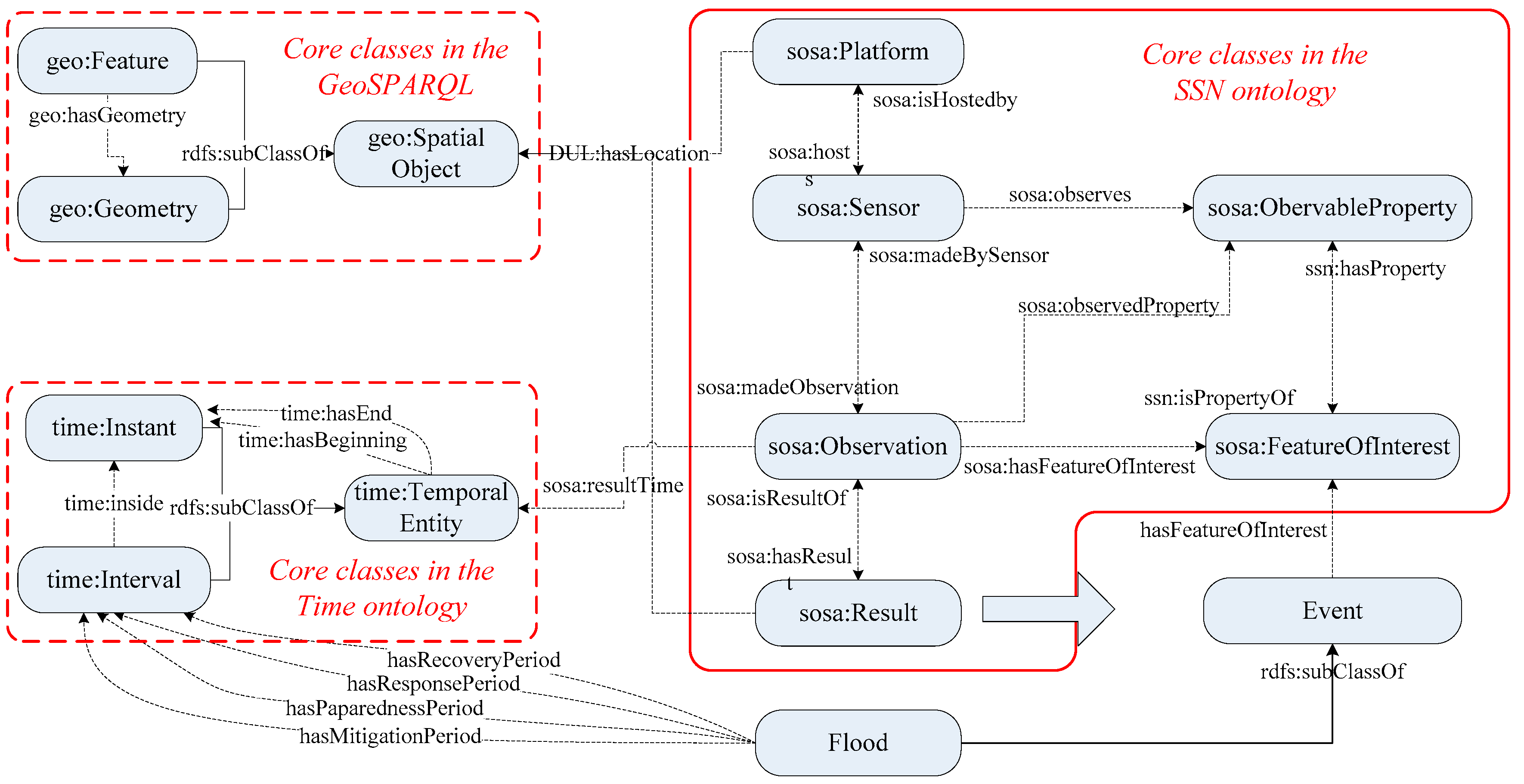
2.1. The Framework of the Hydrological Sensor Web Ontology

To represent the static and dynamic information during hydrology monitoring and the flood procedure, the hydrological sensor web ontology must be able to
  • support various observation platforms (for example, hydrological stations and weather stations);
  • achieve the chains in Platform–Sensor–Observation–Process–FeatureOfInterest (FOI)–Result, to semantically search requisite observation resources exactly;
  • apply time and space properties to gain specific sensors or observation data at a specified time and place; and
  • allow information fusion calculation with heterogeneous observation data to acquire new knowledge.
To satisfy the features mentioned above, the hydrological sensor web ontology was designed as shown in Figure 1, using the Protégé software [28].
Figure 1 illustrates the core classes of the hydrological sensor web ontology, including Platform, Sensor, Observation, FeatureOfInterest, ObservableProperty, and Result, from the SSN ontology. In addition to the class definition, the object properties are also defined and are mainly used to connect a subject with an object in a “subject–predicate–object” triple structure. For instance, the object property hosts connects the class Platform and class Sensor in “Platform-hosts-Sensor”, the object property madeObservation connects the class Sensor and class Observation in “Sensor-madeObservation-Observation”, and so on.
For extension in the temporal dimension, the W3C Time ontology (mainly Temporal Entity and subclasses Time instant and Time Interval) was applied as the time property and used for searching suitable sensor web resources within a required time. OGC GeoSPARQL was imported to define the vocabulary for representing geospatial data in the ontology and to process geospatial data and spatial reasoning by extending the SPARQL query language. OGC GeoSPARQL core classes (including SpatialObject, Feature, and Geometry) were used to describe spatial information. The object properties of GeoSPARQL (such as covers, crosses, meets, and within) were used to determine topological relations between the request area and the observation area.
In addition, the class Event was created in the proposed ontology, and further subclasses flood, rainstorm, etc. were built according to various kinds of disaster events.

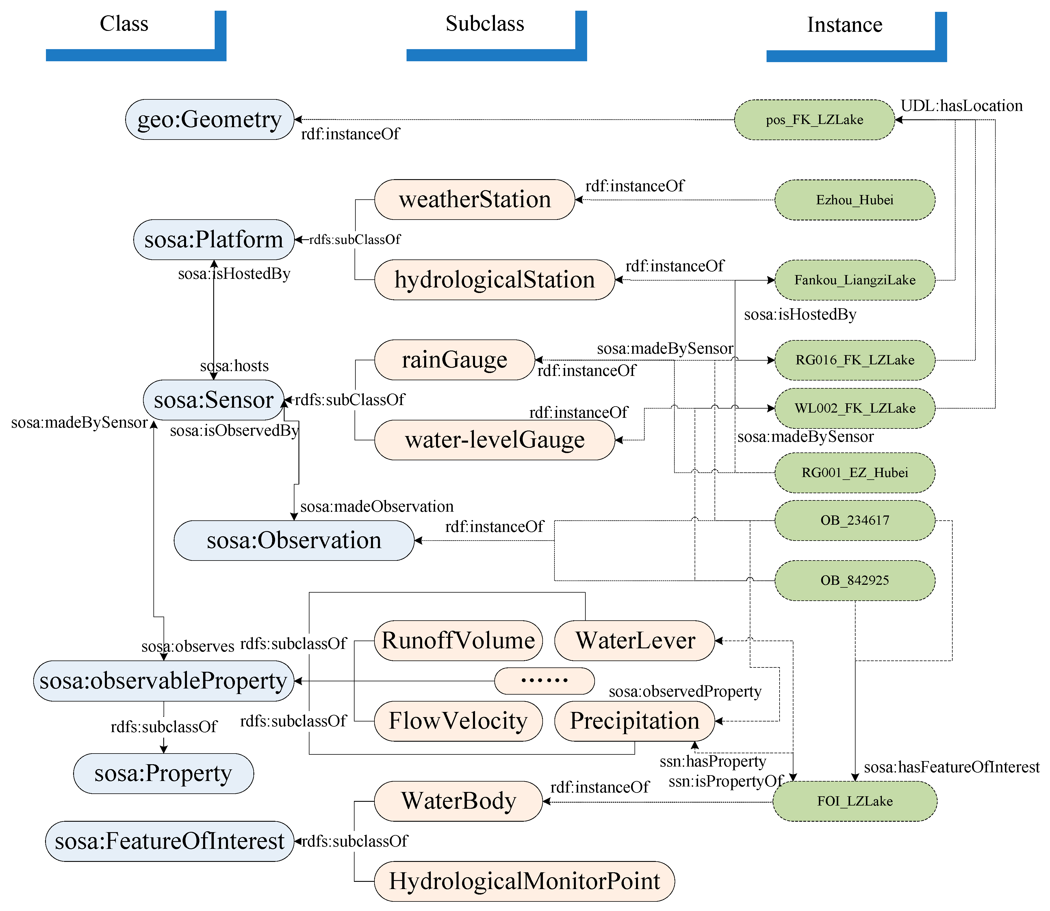
2.2. Hydrological Domain Extension and Instantiation

As mentioned above, the precipitation and water level, the most important observations for flood management, could be made by various sensors deployed on weather stations or hydrologic stations. Thus, the main subclasses were designed as shown in Figure 2. For flood management, weatherStation and hydrologicalStation were created as subclasses of the Platform class. rainGauge and water-levelGauge are subclasses of Sensor. WaterLevel, Precipitation, etc., are subclasses of the observableProperty class. The WaterBody and HydrologicalMonitorPoint are subclasses of the FeatureOfInterest class. All the subclasses are shown in the middle of Figure 2.
Subsequently, the instances shown to the right of Figure 2 were created according to the actual observation system and data in Liangzi Lake, located in the southeastern part of Wuhan, China. Spatial, temporal, and other specific properties of these platforms, sensors, and observations are described in the ontology.

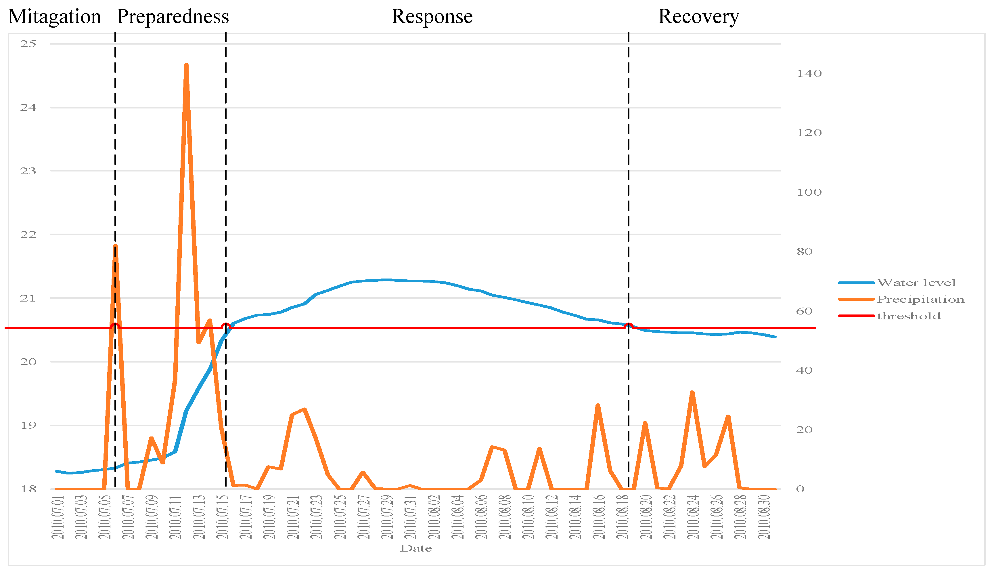
2.3. Rules for Recognizing the Stages of the Floods

In semantic technology, rules are formulated from realistic restrictions and used to acquire new knowledge based on the existing classes and relationships of ontologies. These restrictions, called rules, are extracted from professional experiences and understanding. The Semantic Web Rule Language (SWRL) [29] was designed to be the standard rule language of the Semantic Web. It allows users to write rules expressed in terms of W3C Web Ontology Language (OWL) concepts to reason with OWL individuals. The rules can be used to infer new knowledge from existing OWL knowledge bases [30].
According to the specification of SWRL, a suite of rules for recognizing flood stages were set up based on existing knowledge as follows.
Natural hydrological disasters are dynamic with continuous changes. The United Nations International Strategy for Disaster Risk (UNISDR) defines the four phases of disasters as mitigation, preparedness, response, and recovery [31]. Actions and foci of these four stages are discrepant, different sensors, observations, and FOIs. For example, early warning forecast observation data are collected mainly in the preparedness stage as the spatial and temporal distribution and development data of the disasters are necessary in the emergency response stage. The disaster event information modeling needs to be considered in stages [32,33]. The rules are also designed based on these four stages.
In general, the precipitation and water level is usually used to determine the status of the flood. Due to different geographic situations and terrains, each river or lake has its own threshold of warning water level. Precipitation is another major cause of the formation of the flood. In China, rain with precipitation more than 50 mm and less than 99.9 mm per day is called a “rainstorm,” and was set as the threshold of the precipitation. When the values of both the water level and precipitation are under the respective thresholds, the river is regarded as being in the mitigation stage. If the precipitation reaches the rainstorm level while the water level is normal, the date is regarded as the start of the preparedness stage, and early warnings are given. Once the water level exceeds the threshold of the warning level, it is time to shift into the response stage. When the water level falls below the warning level, the recovery stage begins. Using the SWRL, the four stages are described as follows: t is the date, t − 1 is the date one day before t, and t + 1 is the date one day after t. The initial date should be recognized as the start date of a flood’s mitigation stage and the end date of a flood’s mitigation stage can be acquired by the SWRL sentence as (1), the start date of a flood’s preparedness stage can be acquired by the SWRL sentence as (2), and the end date of a flood’s preparedness stage can be acquired by the SWRL sentence as (3). The start date of a flood’s response stage can be acquired by the SWRL sentence as (4), and the end date of a flood’s response stage can be acquired by the SWRL sentence as (5). The start date of a flood’s recovery stage can be acquired by the SWRL sentence as (6), and, if no other mitigation stage begins, the final data time can be considered as the end date of a flood’s recovery stage. Details of the SWRL sentences are shown as follows.
l e s s T h a n ( w a t e r l e v e l t ,   t h r e s h o l d _ f o r _ w a t e r l e v e r )   l e s s T h a n ( p r e c i p i t a t i o n t ,     t h r e s h o l d f o r p r e c i p i t a t i o n )   l e s s T h a n ( w a t e r l e v e l t + 1 ,   t h r e s h o l d _ f o r _ w a t e r l e v e r )   g r e a t e r T h a n ( p r e c i p i t a t i o n t + 1 ,     t h r e s h o l d _ f o r _ p r e c i p i t a t i o n ) } => hasEnd(mitigation,t)
l e s s T h a n ( w a t e r l e v e l t 1 ,     t h r e s h o l d f o r w a t e r l e v e r )   l e s s T h a n ( p r e c i p i t a t i o n t 1 ,     t h r e s h o l d f o r p r e c i p i t a t i o n )   l e s s T h a n ( w a t e r l e v e l t ,   t h r e s h o l d f o r w a t e r l e v e r )   g r e a t e r T h a n ( p r e c i p i t a t i o n t ,     t h r e s h o l d f o r p r e c i p i t a t i o n ) } => hasBeginning(preparednessStage,t)
l e s s T h a n ( w a t e r l e v e l t ,     t h r e s h o l d _ f o r _ w a t e r l e v e r ) g r e a t e r T h a n ( w a t e r l e v e l t + 1 ,     t h r e s h o l d _ f o r _ w a t e r l e v e l ) } => hasEnd(preparednessStage,t)
l e s s T h a n ( w a t e r l e v e l t , t h r e s h o l d _ f o r _ w a t e r l e v e l ) g r e a t e r T h a n ( w a t e r l e v e l t + 1 ,   t h r e s h o l d _ f o r _ w a t e r l e v e l ) } => hasBeginning(response,t)
g r e a t e r T h a n ( w a t e r l e v e l t ,   t h r e s h o l d _ f o r _ w a t e r l e v e l ) l e s s T h a n ( w a t e r l e v e l t + 1 , t h r e s h o l d _ f o r _ w a t e r l e v e l ) } => hasEnd(response,t)
g r e a t e r T h a n ( w a t e r l e v e l t ,   t h r e s h o l d _ f o r _ w a t e r l e v e l )   l e s s T h a n ( p r e c i p i t a t i o n t ,     t h r e s h o l d _ f o r _ p r e c i p i t a t i o n )   l e s s T h a n ( w a t e r l e v e l t + 1 ,   t h r e s h o l d _ f o r _ w a t e r l e v e r )   l e s s T h a n ( p r e c i p i t a t i o n t + 1 ,     t h r e s h o l d _ f o r _ p r e c i p i t a t i o n ) } => hasBeginning(recovery,t)

3. Experimental Data and Results

3.1. Experimental Data

In China, floods occur most frequently in the Yangtze River Basin. The complex regional terrains and the East Asia Monsoon shape the great spatio-temporal variability of the rainfall during the flood season. Therefore, it is important to improve the adequate hydrological and meteorological monitoring for flood prevention and mitigation, as well as the exploitation and utilization of water resources in the Yangtze River Basin [34].
Liangzi Lake, with an area of ~280 km2, is one of the largest lakes of the Yangtze River Basin and has important effects on the surrounding areas. The flood that occurred at Liangzi Lake between 1 July 2010 and 31 August 2010 was the largest flood since 1998 and is considered long-term. Thus, the data from Liangzi Lake during 1 July 2010 and 31 August 2010 were chosen as the experimental object. The experimental data were gathered from local observation stations at Liangzi Lake.
In the experiment, two types of platforms were involved: hydrological and meteorological monitoring platforms. Three kinds of sensors were deployed on these platforms, and the observations made by these sensors were used. The adoptive sensors consisted of eight rain gauges, eight water level gauges, and six flow meters. The corresponding observations referred to precipitation, daily water level, and daily flow volume of the Jinsha River area and Liangzi Lake in the Yangtze River Basin from 1 July 2010 to 31 August 2010.

3.2. Ontological Implementation for Flood Management

Heterogeneous flood related information can be recognized, managed, and reused. The flood ontology based on the ontological structure described in Section 2.1 was created with Protégé.
The main flood management-related classes contain the HydrologicalStation and WeatherStation subclasses of Platform; the RainGauge, WaterlevelGauge, etc., subclasses of Sensor; the FlowVolume, Precipitation, RunoffVolume, and WaterLevel subclasses of ObservableProperty; and the WaterBody, a subclass of FeatureOfInterest.
The object properties in the ontology link classes/individuals to classes/individuals. They are the most important elements in the ontology and act as the glue to bridge the gap between heterogeneous hydrological sensor web resources. The main object properties in the proposed ontology are listed in Table 2.
The visualized presentation of the classes, object properties, and individual definitions of the ontology fragment are demonstrated in Figure 3.

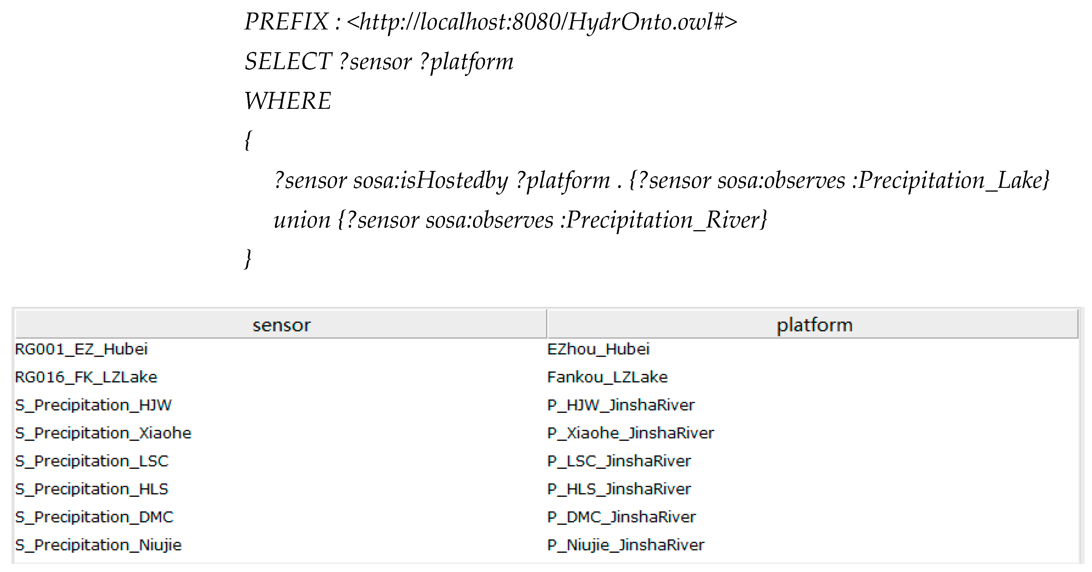
3.3. Semantic Query Based on the Hydrological Sensor Web Ontology

To evaluate the proposed hydrological sensor web ontology, a series of semantic querying and reasoning was designed. Semantic querying included (1) querying all sensors observing the precipitation of rivers “Precipitation_River” and their platforms; (2) querying all sensors whose observations were in the area of the Jinsha River “FOI_JinshaRiver” and their platforms; and (3) acquiring the exact dates on which the precipitation was greater than 10 mm per day and the water level was greater than 19 mm per day in the Liangzi Lake. Reasoning included recognizing the start date of the flood’s preparedness stage. The querying language was encoded in the semantic web query language SPARQL and implemented by the Protégé SPARQL Plugin (version 2.0.1) in Protégé (version 5.0.0), and the rule language for reasoning was based on the SWRL and implemented by SWRLTab Protégé 5.0 + Plugin (version 2.0.4) in Protégé (version 5.0.0).

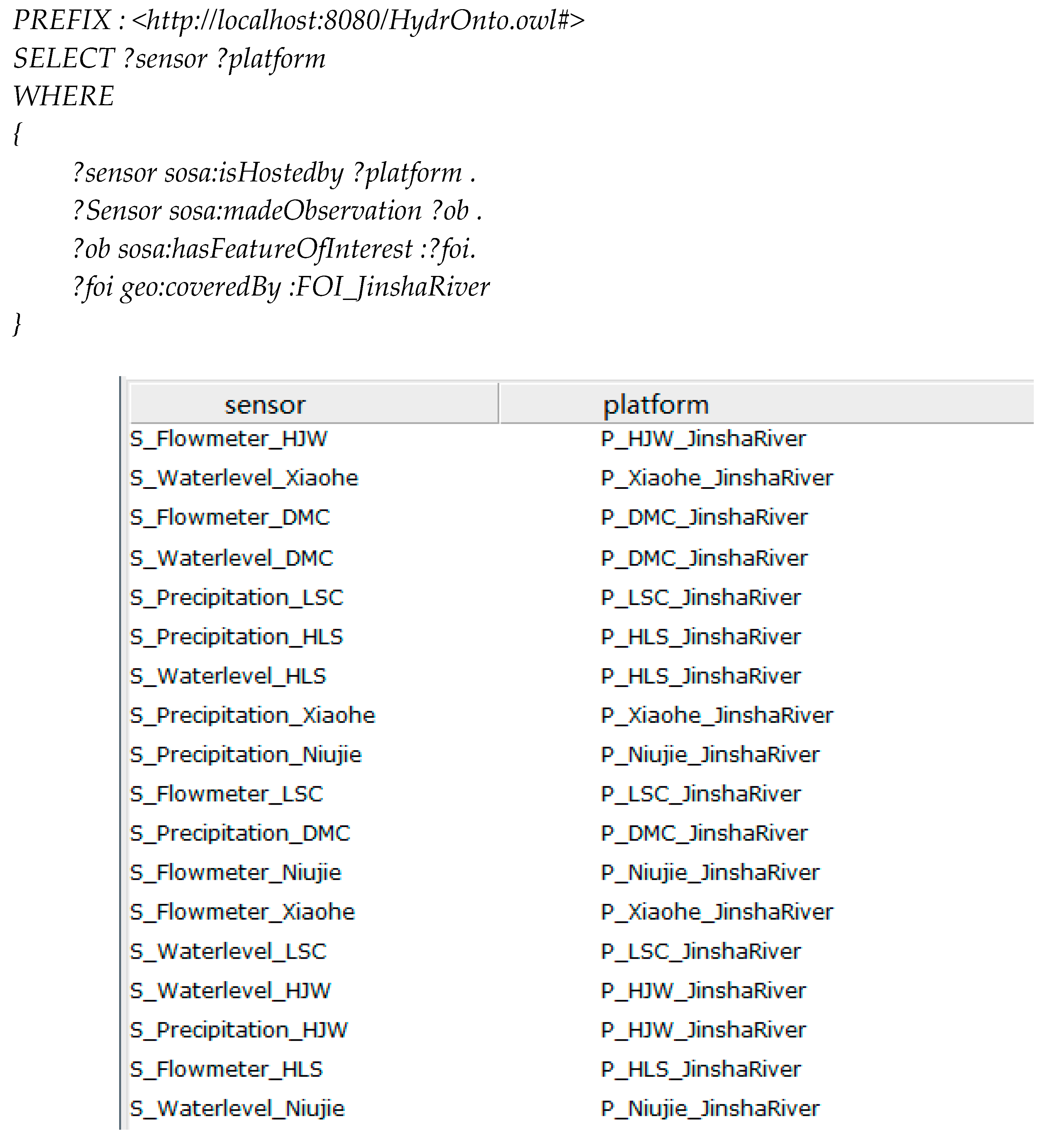
3.3.1. Specific Theme Query

First of all, acquiring various sensors that can obtain the particular observed property is required frequently. For example, all rain gauges could be acquired by following the SWRL sentence, based on the presented hydrological sensor web ontology model, the results of which are shown in Figure 4.
In the result, eight pairs of sensors and platforms which observed the precipitation of both lakes and rivers were filtered from the dataset. This selection also contained all the eligible sensors and platforms that we surveyed. Additionally, all platforms and sensors in the Jinsha River could also be acquired by the following sentence and the results are shown in Figure 5 (Damaocun, Xiaohe, Longshancun, Niujie and Huanglishu are five parts of the Jinsha River; instances of the class FeatureOfInterest, FOI_DMC, FOI_Xiaohe, FOI_LSC, FOI_NJ, FOI_HLS, were covered by FOI_JinshaRiver):
In the result, 18 pairs of sensors and platforms that observed the three observable properties (flow volume, precipitation, and water level) of Jinsha_River were filtered from the experimental period, and this selection contained all the eligible sensors and platforms that we surveyed. The exact dates on which the precipitation was greater than 10 mm per day and the water level was greater than 19 m in the Liangzi Lake could be acquired by the following sentence and the results are shown in Figure 6:
In the result, 15 days on which the precipitation was greater than 10 mm per day and the water level was greater than 19 m at the Liangzi Lake were filtered from all the experimental observation datasets, and this selection contained all the eligible sensors and platforms that we surveyed.

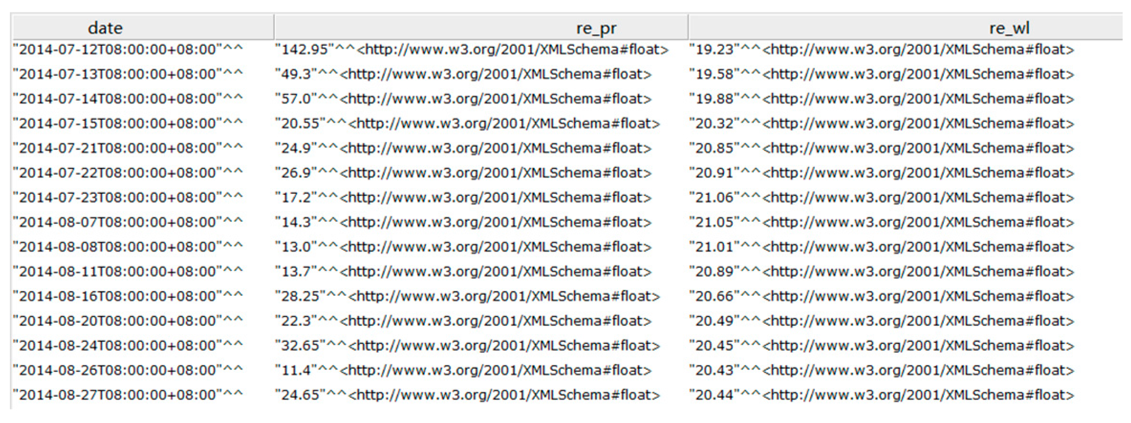
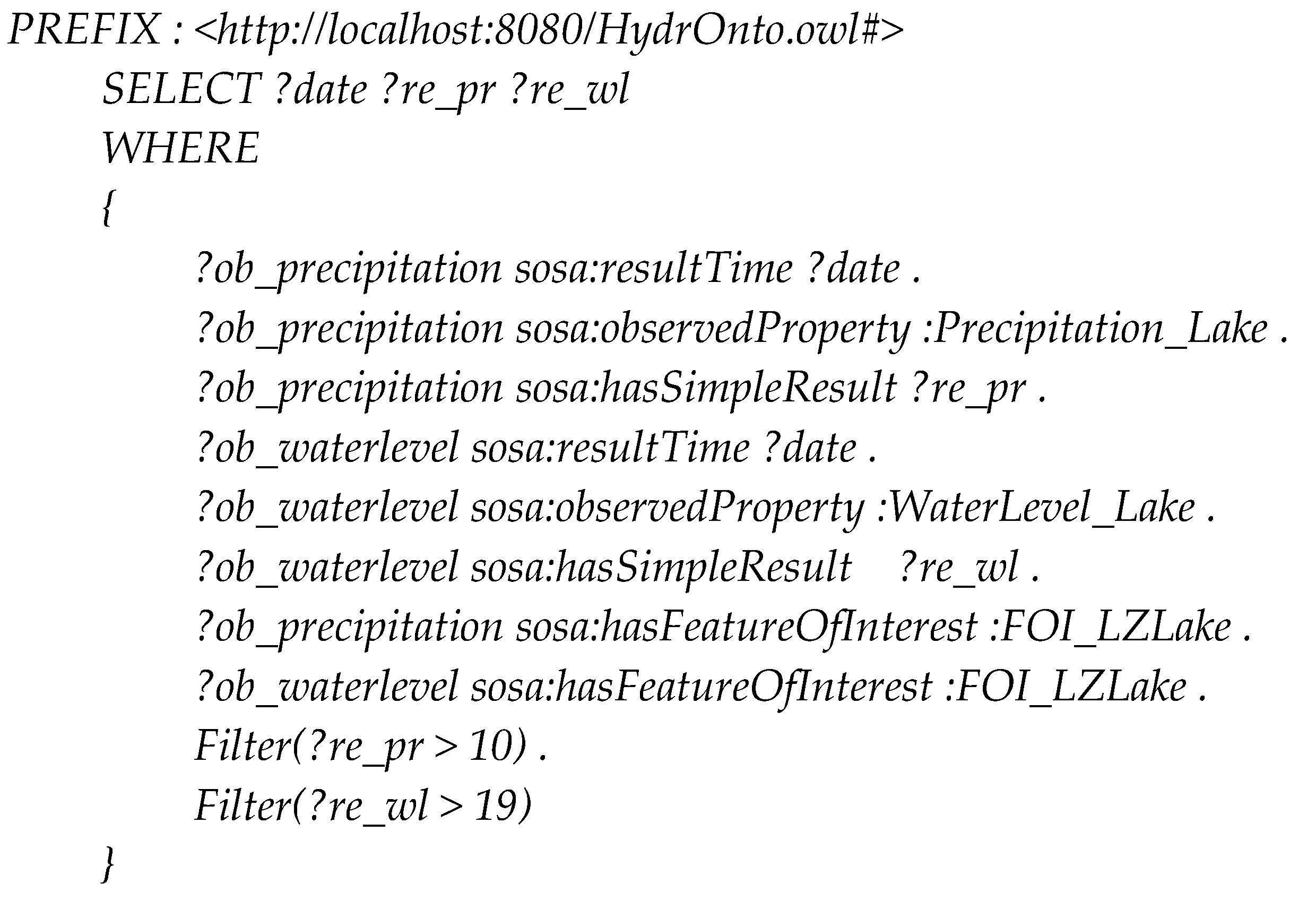
3.3.2. Knowledge Reasoning

As described in Section 2.2, experientially, the water level threshold value for the flood of the Liangzi Lake was set at 20.5 m, contingent on the terrain and meteorological conditions. The precipitation threshold value for causing the flood was set at 50 mm, the same definition as the rainstorm. In accordance with the rules defined in Section 2.2, the point when the water level was less than 20.5 and the earliest date of the rainfall was less than 50 mm was assigned as the start time of the flood preparedness stage. The day before this date could be assigned as the end of the flooding season; the earliest date on which the water level was greater than 20.5 m was the start time of the flood response stage; the day before this date was the end of the flood preparedness stage; the latest date on which the water level was greater than 20.5 m was the end time of the response stage; and the day after this date was the start time of the recovery stage. The above can be described by the following SWRL sentence:
PREFIX : <http://localhost:8080/HydrOnto.owl#>
sosa:resultTime(?ob_precipitation, ?date) sosa:hasFeatureOfInterest(?ob_precipitation, FOI_LZLake)sosa:observedProperty(?ob_precipitation, Precipitation_Lake)sosa:hasSimpleResult(?ob_precipitation, ?re_pr)swrlb:greaterThan(?re_pr, 50)sosa:resultTime(?ob_waterlevel, ?date)sosa:hasFeatureOfInterest(?ob_waterlevel, FOI_LZLake)sosa:observedProperty(?ob_waterlevel, WaterLevel_Lake)sosa:hasSimpleResult(?ob_waterlevel, ?re_wl)swrlb:lessThan(?re, 20.5) -> :preparednessBeginAt(Flood_LZLake_1, ?date)
Using the established rules to infer the flood stages from the precipitation and water level observation data, the flood stages could be divided as shown in Figure 7.
After reasoning, the flood at Liangzi Lake in summer 2010 was divided into four stages: (1) the mitigation stage from 1 to 5 July 2010 when the precipitation and water level were normal; (2) the preparedness stage from 6 to 15 July 2010 when the water level kept rising, beginning at the date on which the precipitation exceeded the threshold value and ending before the date on which the water level exceeded the threshold value; (3) the response stage from 16 July to 19 August 2010 when the water level was kept beyond the threshold value; and (4) the recovery stage from 20 to 31 August 2010 when the water level fell below the threshold value and the precipitation was normal.

4. Discussion

As can be seen in the results of the experiment, the semantic querying and reasoning could arrive at the expected results in complex conditions. The hydrological sensor web ontology proposed in this paper could support querying the heterogeneous resources of the hydrological sensor web and recognize the various stages of the flood events. It provided a novel method for identifying the key time nodes by dynamical data observed by the hydrological sensor network. In addition, the ontology construction method could be extended to other observation domains conveniently. The detailed benefits are discussed as follows.

4.1. Collaborative Monitoring for Hydrological Events and Processes

Currently, many systems and sensors are being used in hydrological monitoring such as the South Esk hydrological sensor web in Tasmania, Australia [16], the multi-source precipitation observations in the Yangtze River Basin [34], and the turbidity extraction for Poyang Lake, integrating Sensor Web Enable and Web Processing Service [35]. Nevertheless, these resources are typically used individually, and their effects do not meet the requirements for observing events comprehensively and dynamically. The proposed ontology is based on the SSN ontology and has comprehensive descriptions of the observation resource classes and the relationships between them, including the observation platform, the sensor, the observation, the feature of interest, the observable property, and so on; in addition, the time and space ontology are introduced to support the description, querying, and reasoning in the temporal and spatial dimensions. Furthermore, the ontology is extended with the event class.
Based on the proposed ontology, all resources in demand could be acquired by the semantic web query language. As introduced in Section 3.3.1, all related sensors and platforms, which observe particular properties at particular times in particular locations, could be acquired with a simple sentence. The proposed ontology makes it possible to obtain more comprehensive hydrological information collaboratively. This is significant for the full use of the existing hydrological sensor web resources.

4.2. Knowledge Acquisition with Reasoning Rules from Multiple Kinds of Hydrological Sensor Web Resources

With the rapid development of sensor technology, massive amounts of data are being acquired and accumulated. Obtaining knowledge automatically with machine-interpretable/machine-understandable rules from the various data is significant. Earlier studies of hydrological modeling lack a knowledge-based approach to connect the results of heterogeneous observations. As the experiment in Section 3.3.2 showed, SWRL is imported in the proposed ontological model to recognize the critical time nodes of the flood. The method is generally applicable for other hydrological knowledge acquisitions and even for applications in other environment observation domains such as climate change, precision agriculture, surface deformation monitoring, and emergency decision-making, which requires the extensible use of various observation data accompanied with temporal and spatial information.

5. Conclusions

This paper proposes an ontology for hydrological monitoring that was used to the recognition of flood stages. This ontology was developed by extending the W3C SSN ontology with thematic, spatial, and temporal semantics. Flood stages in areas of the Yangtze River were recognized. In the experiments, three kinds of sensors, for a total of 22 sensors, and their observation data in two months were utilized, and the feasibility and usability of the proposed ontology was demonstrated by semantic querying and knowledge acquisition.
Our work provides a semantic method for integrating hydrological heterogeneous sensor web resources and for acquiring high-level knowledge from various observation data through reasoning rules. Another important contribution is that the procedure of ontology modeling described in this paper demonstrates how to extend a top-level ontology such as the W3C SSN ontology for domain purposes. Hydrological experts can add more classes, properties, and rules into the proposed ontology to adapt to new purposes.
There are several future research directions for this research. First, we are supplementing instances and rules to describe more hydrological sensor web resources and acquire useful knowledge from existing data. A prototype is also being developed to provide a friendly user interface to allow end users to model, query, and reason with the proposed ontology. In addition, numerous related standards have emerged in recent years [36] such as the W3C Web of Things (standards for the Web of Things developed by the World Wide Web Consortium) [37], the ETSI M2M (a set of specifications of Machine to Machine released by the European Telecommunications Standards Institute) [38] and OneM2M [39,40]; to ensure that the proposed ontology abides by these standards is an important future endeavor. Furthermore, after the necessary amendments, the ontology and dataset used in this paper will be submitted to professional websites for sharing ontologies or datasets, such as the Linked Open Vocabularies for Internet of Things (LOV4IoT) [41] and datahub [42].

Acknowledgments

This work was supported by grants from the National Nature Science Foundation of China (NSFC) Program (41601406), the National Key Research and Development Program of China (No. 2017YFB0503803), and the China Scholarship Council (CSC) Foundation (Chao Wang, no. 201606275140). This work was conducted using the Protégé resource, which was supported by grant GM10331601 from the National Institute of General Medical Sciences of the United States National Institutes of Health.

Author Contributions

Chao Wang, Nengcheng Chen, and Wei Wang conceived of the idea of the paper. Chao Wang and Zeqiang Chen analyzed the data and performed the experiments. Chao Wang wrote the paper.

Conflicts of Interest

The authors declare no conflict of interest.

References

  1. Sheth, A.P.; Sahoo, S.S. Semantic Sensor Web. IEEE Int. Comput. 2008, 12, 78–83. [Google Scholar] [CrossRef]
  2. Pundt, H. The semantic mismatch as limiting factor for the use of geospatial information in disaster management and emergency response. In Geospatial Information Technology for Emergency Response, 1st ed.; Zlatanova, S., Li, J., Eds.; Taylor & Francis: Bristol, PA, USA, 2008; pp. 243–256. [Google Scholar]
  3. Compton, M.; Neuhaus, H. Reasoning about Sensors and Compositions. In Proceedings of the 2nd International Workshop on Semantic Sensor Networks, Washington, DC, USA, 25–29 October 2009; CEUR-WS: Aachen, Germany, 2009. [Google Scholar]
  4. Rueda1, C.; Galbraith, N.; Morris, R.A.; Bermudez, L.E.; Arko, R.A.; Graybeal, J. The MMI Device Ontology: Enabling Sensor Integration. In Proceedings of the American Geophysical Union Fall Meeting 2010, San Francisco, CA, USA, 13–17 December 2010. [Google Scholar]
  5. Bermudez, L.; Delory, E.; Reilly, T.O. Ocean Observing Systems Demystified. In Proceedings of the OCEANS 2009, MTS/IEEE Biloxi—Marine Technology for Our Future: Global and Local Challenges, Biloxi, MS, USA, 26–29 October 2009. [Google Scholar]
  6. Agresta, A.; Fattoruso, G.; Pollino, M.; Pasanisi, F.; Tebano, C.; De Vito, S.; Di Francia, G. An ontology framework for flooding forecasting. In Proceedings of the 14th International Conference on Computational Science and Its Applications, Guimarães, Portugal, 30 June–3 July 2014. [Google Scholar]
  7. Avancha, S.; Patel, C.; Joshi, A. Ontology-Driven Adaptive Sensor Networks. In Proceedings of the First Annual International Conference on Mobile and Ubiquitous Systems: Networking and Services, Boston, MA, USA, 22–25 August 2004. [Google Scholar]
  8. Semantic Sensor Network XG Final Report. Available online: https://www.w3.org/2005/Incubator/ssn/XGR-ssn-20110628/ (accessed on 12 November 2017).
  9. Semantic Sensor Network Ontology—W3C Recommendation 19 October 2017. Available online: https://www.w3.org/TR/vocab-ssn/ (accessed on 7 December 2017).
  10. Botts, M.; Robin, A. OpenGIS Sensor Model Language (SensorML) Implementation Specification. Available online: http://portal.opengeospatial.org/files/?artifact_id=21273 (accessed on 12 November 2017).
  11. Cox, S. Geographic Information: Observations and Measurements; Document OGC 10-004r3/ISO 19156; Open Geospatial Consortium Inc.: Wayland, MA, USA, 2010. [Google Scholar]
  12. Bröring, A.; Echterhoff, J.; Jirka, S.; Simonis, I.; Everding, T.; Stasch, C.; Liang, S.; Lemmens, R. New generation sensor web enablement. Sensors 2011, 11, 2652–2699. [Google Scholar] [CrossRef] [PubMed]
  13. Compton, M.; Barnaghi, P.; Bermudez, L.; García-Castro, R.; Corcho, O.; Cox, S.; Graybeal, J.; Hauswirth, M.; Henson, C.; Herzog, A.; et al. The SSN ontology of the W3C semantic sensor network incubator group. J. Web Semant. 2012, 17, 25–32. [Google Scholar] [CrossRef] [Green Version]
  14. Calbimonte, J.; Jeung, H.; Corcho, O.; Aberer, K. Enabling query technologies for the semantic sensor web. Int. J. Semant. Web Inf. 2012, 8, 43–63. [Google Scholar] [CrossRef] [Green Version]
  15. Llaves, A.; Corcho, O.; Taylor, P.; Taylor, K. Enabling RDF Stream Processing for Sensor Data Management in the Environmental Domain. Int. J. Semant. Web Inf. 2016, 12, 1–21. [Google Scholar] [CrossRef]
  16. Dutta, R.; Morshed, A. Performance evaluation of south Esk hydrological sensor web: Unsupervised machine learning and semantic linked data approach. IEEE Sens. J. 2013, 13, 3806–3815. [Google Scholar] [CrossRef]
  17. Ploennigs, J.; Schumann, A.; Lécué, F. Adapting semantic sensor networks for smart building diagnosis. In Proceedings of the International Semantic Web Conference, Riva del Garda, Italy, 19–23 October 2014. [Google Scholar]
  18. Dey, S.; Jaiswal, D.; Dasgupta, R.; Mukherjee, A. Organization and management of semantic sensor information using SSN ontology: An energy meter use case. In Proceedings of the 2015 9th International Conference on Sensing Technology, Auckland, New Zealand, 8–10 December 2015. [Google Scholar]
  19. Fernandez, S.; Ito, T. Using SSN Ontology for Automatic Traffic Light Settings on Inteligent Transportation Systems. In Proceedings of the IEEE International Conference on Agents (ICA), Matsue, Japan, 28–30 September 2016. [Google Scholar]
  20. Ruta, M.; Scioscia, F.; Pinto, A.; Di Sciascio, E.; Gramegna, E.F.; Ieva, S.; Loseto, G. Resource annotation, dissemination and discovery in the Semantic Web of Things: A CoAP-based framework. In Proceedings of the 2013 IEEE International Conference on Green Computing and Communications and IEEE Internet of Things and IEEE Cyber, Physical and Social Computing, Beijing, China, 20–23 August 2013. [Google Scholar]
  21. Gramegna, F.; Ieva, S.; Loseto, G.; Pinto, A. Semantic-enhanced resource discovery for CoAP-based sensor networks. In Proceedings of the 5th IEEE International Workshop on Advances in Sensors and Interfaces, Bari, Italy, 13–14 June 2013. [Google Scholar]
  22. Wei, W.; Barnaghi, P. Semantic annotation and reasoning for sensor data. In Lecture Notes in Computer Science, Proceedings of the 4th European Conference on Smart Sensing and Context, Guildford, UK, 16–18 September 2009; Springer: Berlin, Germany, 2009. [Google Scholar]
  23. Pfisterer, D.; Romer, K.; Bimschas, D.; Kleine, O.; Mietz, R.; Truong, C.; Hasemann, H.; Kroller, A.; Pagel, M.; Hauswirth, M.; et al. SPITFIRE: Toward a Semantic Web of Things. IEEE Commun. Mag. 2011, 49, 40–48. [Google Scholar] [CrossRef]
  24. Bizer, C.; Heath, T.; Berners-Lee, T. Linked data-the story so far. Int. J. Semant. Web Inf. 2009, 5, 1–22. [Google Scholar] [CrossRef]
  25. Gyrard, A.; Bonnet, C.; Bonnet, K.; Serrano, M. LOV4IoT: A Second Life for Ontology-Based Domain Knowledge to Build Semantic Web of Things Applications. In Proceedings of the 2016 IEEE 4th International Conference on Future Internet of Things and Cloud (FiCloud), Vienna, Austria, 22–24 August 2016. [Google Scholar]
  26. Cox, S.; Little, C. Time Ontology in OWL, W3C Proposed Recommendation 7 September 2017. Available online: http://www.w3.org/TR/owl-time (accessed on 12 November 2017).
  27. Perry, M.; Herring, J. OGC GeoSPARQL—A Geographic Query Language for RDF Data. OGC Implementation Standard. September 2012. Available online: http://www.opengeospatial.org/standards/geosparql (accessed on 12 November 2017).
  28. Musen, M.A. The Protégé project: A look back and a look forward. AI Matters 2015, 1, 4–12. [Google Scholar] [CrossRef] [PubMed]
  29. Horrocks, I.; Patel-Schneider, P.F.; Boley, H.; Tabet, B.; Grosof, B.; Dean, M. SWRL: A Semantic Web Rule Language Combining OWL and RuleML, W3C Member Submission, W3C. Available online: http://www.w3.org/Submission/2004/SUBM-SWRL-20040521/ (accessed on 12 November 2017).
  30. O’connor, M.J.; Knublauch, H.; Tu, S.W.; Musen, M.A. Writing rules for the semantic web using SWRL and Jess. In Proceedings of the 8th International Protégé Conference, Protégé with Rules Workshop, Madrid, Spain, 18–21 July 2005. [Google Scholar]
  31. United Nations Office for Disaster Risk Reduction (UNISDR). UNISDR Terminology of Disaster Risk Reduction; UNISDR: Geneva, Switzerland, 2009. [Google Scholar]
  32. Chen, Z.; Chen, N.; Du, W.; Song, F. A Method of Modelling Flood Event. J. Geo-Inf. Sci. 2015, 17, 644–652. [Google Scholar]
  33. Othman, S.H.; Beydoun, G.; Sugumaran, V. Development and validation of a disaster management metamodel (DMM). Inf. Process. Manag. 2014, 50, 235–271. [Google Scholar] [CrossRef]
  34. Li, Z. Multi-Source Precipitation Observations and Fusion for Hydrological Applications in the Yangtze River Basin. Ph.D. Thesis, Tsinghua University, Beijing, China, May 2015. [Google Scholar]
  35. Zhai, X.; Yue, P.; Zhang, M. A Sensor Web and Web Service-Based Approach for Active Hydrological Disaster Monitoring. ISPRS Int. J. Geo-Inf. 2016, 5, 171. [Google Scholar] [CrossRef]
  36. Gyrard, A.; Datta, S.K.; Bonnet, C.; Boudaoud, K. Standardizing generic cross-domain applications in Internet of Things. In Proceedings of the Globecom Workshops 2014, Austin, TX, USA, 8–12 December 2014. [Google Scholar]
  37. W3C Web of Things at W3C. Available online: https://www.w3.org/WoT/ (accessed on 8 December 2017).
  38. Grieco, L.A.; Alaya, M.B.; Monteil, T.; Drira, K. Architecting information centric ETSI-M2M systems. In Proceedings of the 2014 IEEE International Conference on Pervasive Computing and Communication Workshops (PERCOM WORKSHOPS), Budapest, Hungary, 24–28 March 2014. [Google Scholar]
  39. Swetina, J.; Lu, G.; Jabobs, P.; Ennesser, F.; Song, J. Toward a standardized common M2M service layer platform: Introduction to oneM2M. IEEE Wirel. Commun. 2014, 21, 20–26. [Google Scholar] [CrossRef]
  40. oneM2M. Available online: http://www.onem2m.org/ (accessed on 8 December 2017).
  41. OV4IoT Project. Available online: http://lov4iot.appspot.com/ (accessed on 6 December 2017).
  42. Datahub. Available online: https://datahub.io/search (accessed on 6 December 2017).
Figure 1. The core classes and properties in the hydrological/flood ontology based on Semantic Sensor Network (SSN).
Ijgi 07 00002 g001
Figure 2. Main subclasses and some instances in the hydrological sensor web ontology.
Ijgi 07 00002 g002
Figure 3. Class hierarchy, object properties, and individual definitions of the flood ontology in Protégé. (a) Class hierarchy of the proposed ontology. (b) Object properties of the proposed ontology. (c) Data properties of the proposed ontology.
Ijgi 07 00002 g003
Figure 4. The search result of sensors observing precipitation and the platforms on which these sensors are deployed.
Ijgi 07 00002 g004
Figure 5. The search result of all sensors and platforms in the Jinsha River.
Ijgi 07 00002 g005
Figure 6. The result dates when the precipitation >10 mm and the water level >19 m at Liangzi Lake.
Ijgi 07 00002 g006aIjgi 07 00002 g006b
Figure 7. Stage divisions using the reasoning rules with data of the daily precipitation and water level at Liangzi Lake during the flood period in 2010.
Ijgi 07 00002 g007
Table 1. The namespaces involved in the proposed hydrological sensor web ontology.
PrefixNamespace URIDescription
sosahttp://www.w3.org/ns/sosa/Sensor, Observation, Sample, and Actuator (SOSA) ontology provides a lightweight core for SSN and aims at broadening the target audience and application areas that can make use of Semantic Web ontologies.
ssnhttp://www.w3.org/ns/ssn/This ontology describes sensors, actuators, and observations, and related concepts. It does not describe domain concepts, time, locations, etc. these are intended to be included from other ontologies via OWL imports.
DULhttp://www.ontologydesignpatterns.org/ont/dul/DUL.owl#The DOLCE + DnS Ultralite (DUL) ontology.
To provide a set of upper level concepts that can be the basis for easier interoperability among many middle and lower level ontologies.
timehttp://www.w3.org/2006/time#OWL-Time is an OWL-2 DL ontology of temporal concepts, for describing the temporal properties of resources in the world or described in Web pages.
geohttp://www.opengis.net/ont/geosparql#An RDF/OWL vocabulary for representing spatial information.
geofhttp://www.opengis.net/def/function/geosparql/A set of domain-specific, spatial filter functions for use in SPARQL queries.
xsdhttp://www.w3.org/2001/XMLSchema#Schema namespace as defined by XSD.
rdfhttp://www.w3.org/1999/02/22-rdf-syntax-ns#This is the RDF Schema for the RDF vocabulary terms in the RDF Namespace, defined in RDF 1.1 Concepts.
rdfshttp://www.w3.org/2000/01/rdf-schema#RDF Schema provides a data-modeling vocabulary for RDF data. RDF Schema is an extension of the basic RDF vocabulary.
owlhttp://www.w3.org/2002/07/owl#This ontology partially describes the built-in classes and properties that together form the basis of the RDF/XML syntax of OWL 2.
Table 2. The object properties, domain, range, and the description of main object properties.
Object PropertyDomainRangeDescription
sosa:madeObservationsosa:Sensorsosa:ObservationRelation between a Sensor and an Observation made by the Sensor.
sosa:resultTimesosa:Observationxsd:dateTimeThe result time is the instant of time when the Observation activity was completed.
sosa:observessosa:Sensorsosa:ObservablePropertyRelation between a Sensor and an ObservableProperty that it is capable of sensing.
sosa:observedPropertysosa:Observationsosa:ObservablePropertyRelation linking an Observation to the ObservableProperty that was observed.
sosa:hasFeatureOfInterestsosa:Observationsosa:FeatureOfInterestA relation between an Observation and the entity whose quality was observed
sosa:hostssosa:Platformsosa:SensorRelation between a Platform and a Sensor, hosted or mounted on it.

