
Occlusion-Free Visualization of Important Geographic Features in 3D Urban Environments


Abstract
:1. Introduction
- (1)
- Present a novel interactive visualization framework that integrates three operators to avoid large distortions during disocclusion.
- (2)
- Propose an optimization approach that includes appropriate measures of resemblance and occlusion of FOIs.
- (3)
- Implement a deformable model for urban areas that considers buildings and streets.
2. Related Work
2.1. Visualization of FOI
2.2. Differences between the Proposed Method and Related Methods
- (1)
- Differences between the proposed method and the method of Deng et al. [18].
- (2)
- Differences between the proposed method and the method of Hirono et al. [5].
- (i)
- We use an object-based view to constrain the deformation of the urban shape rather than maintaining orientations of paired parallel lines, because maintaining the lines increases the computation time. Moreover, our method treats the relevant roads and buildings as unit objects to constrain their positions, which reduces the time cost. This approach is quite different from that of Hirono et al. [5].
- (ii)
- We formulate the occlusion-free animation problem as a quadratic programming problem and decompose the matrix during preprocessing, making it possible to generate occlusion-free views from frame to frame at interactive framerates. The optimization method used in [5] preserves the resemblance but does not provide the high system interactivity required in various tasks due to the high computational load involved in optimization.
- (3)
- Differences between the proposed method and the method of Qu et al. [19].
3. Interactive Occlusion-Free 3D Visualization
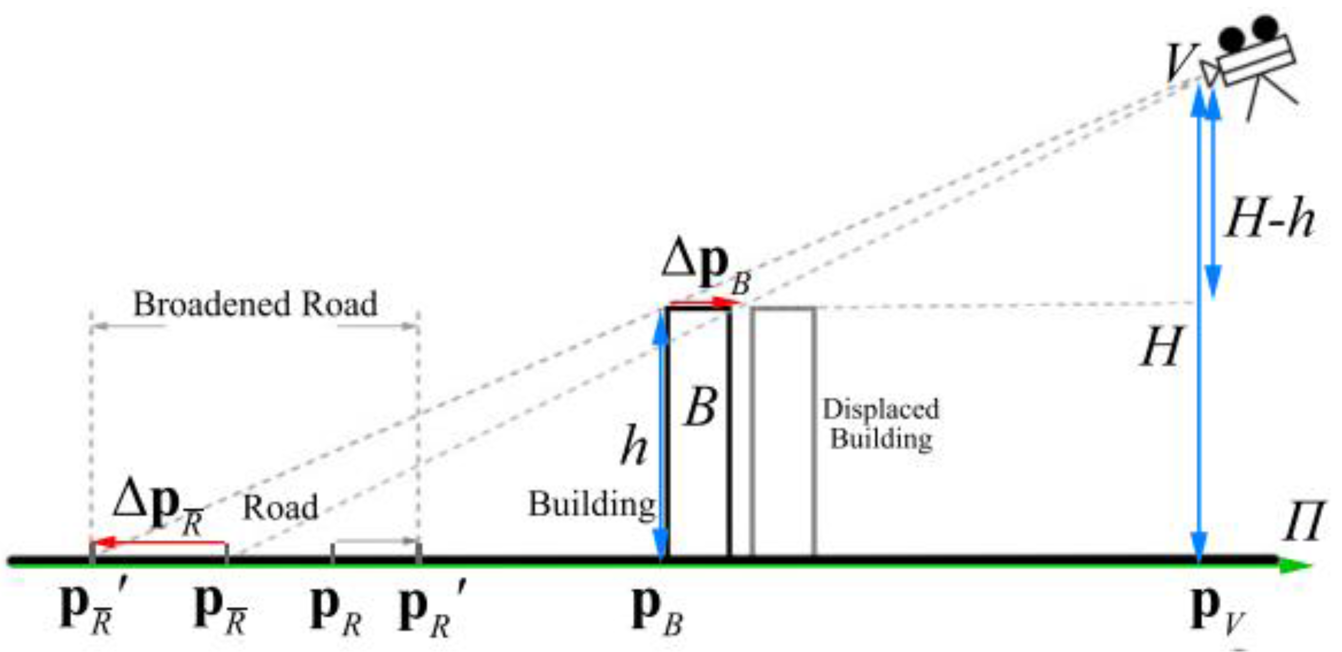
3.1. Problem Statement
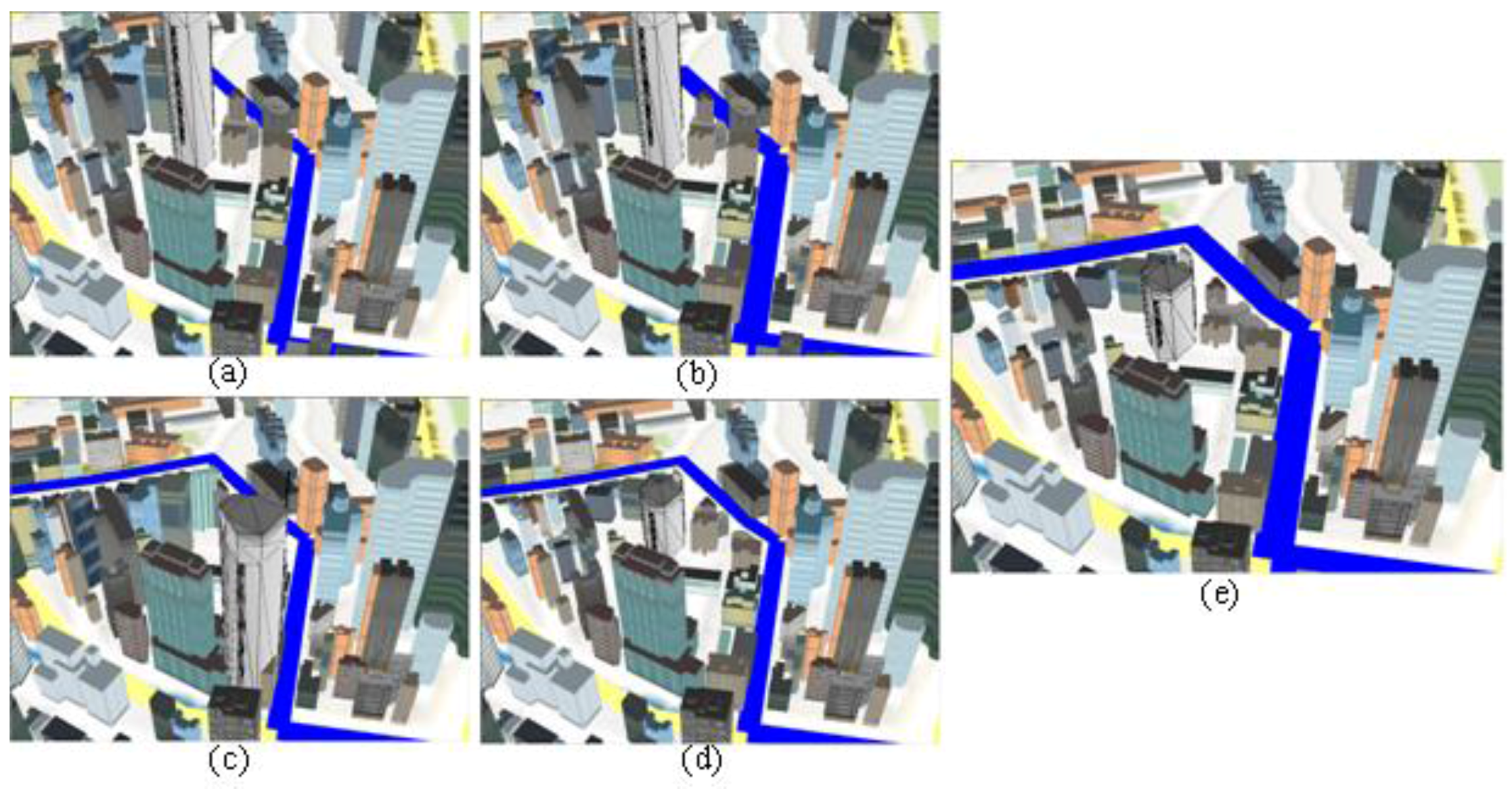
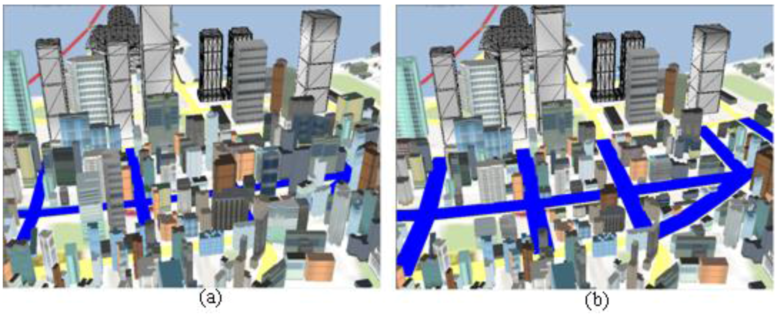
3.2. Disocclusion Operators
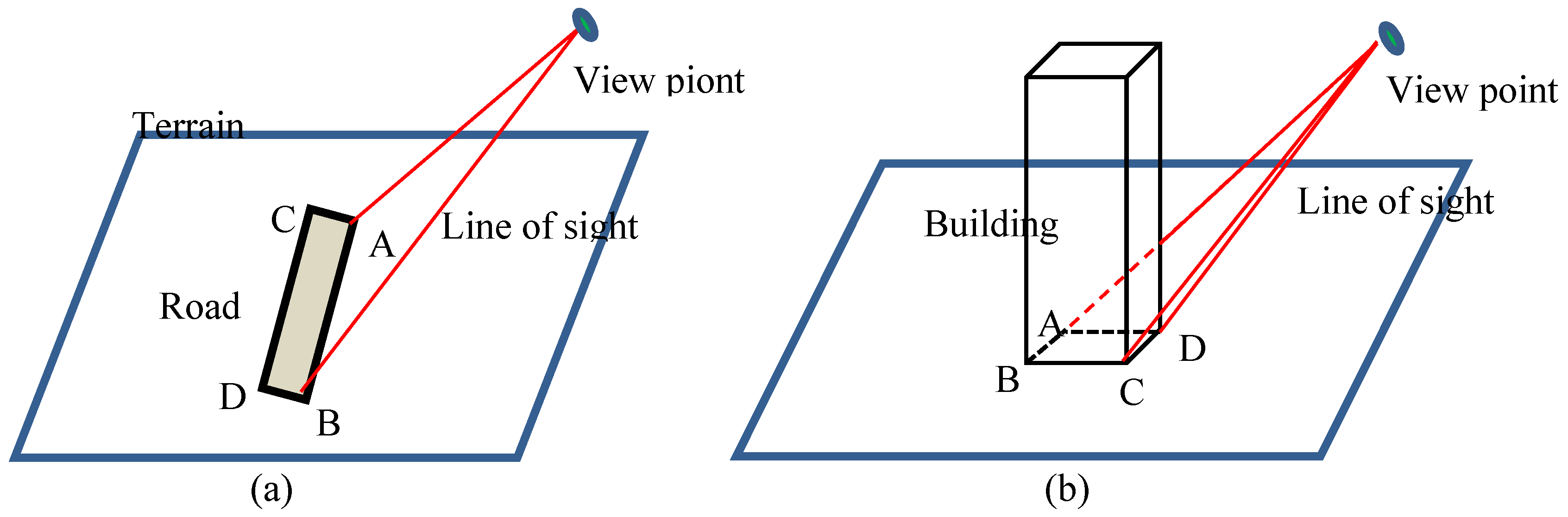
3.3. Occlusion Measurement
3.4. Deviation Measurement
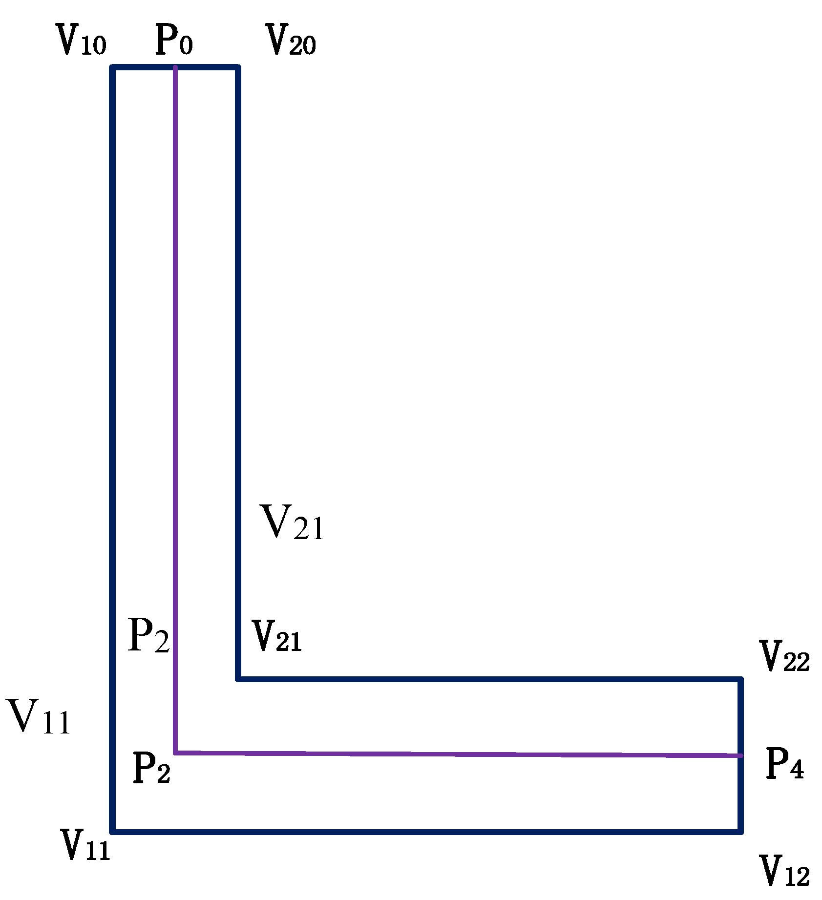
3.4.1. Urban Pattern Extraction
3.4.2. Displacement and Scale Deviation
- (1)
- Global constraint for the relative positions among adjacent buildings
- (2)
- Constraints of buildings in the same block
- (3)
- Constraint of the deviation of the buildings
- (4)
- Road constraint
- (5)
- Constraint of the relative positions between the road and surrounding buildings
- (6)
- Deviation of spatial and temporal coherence constraints
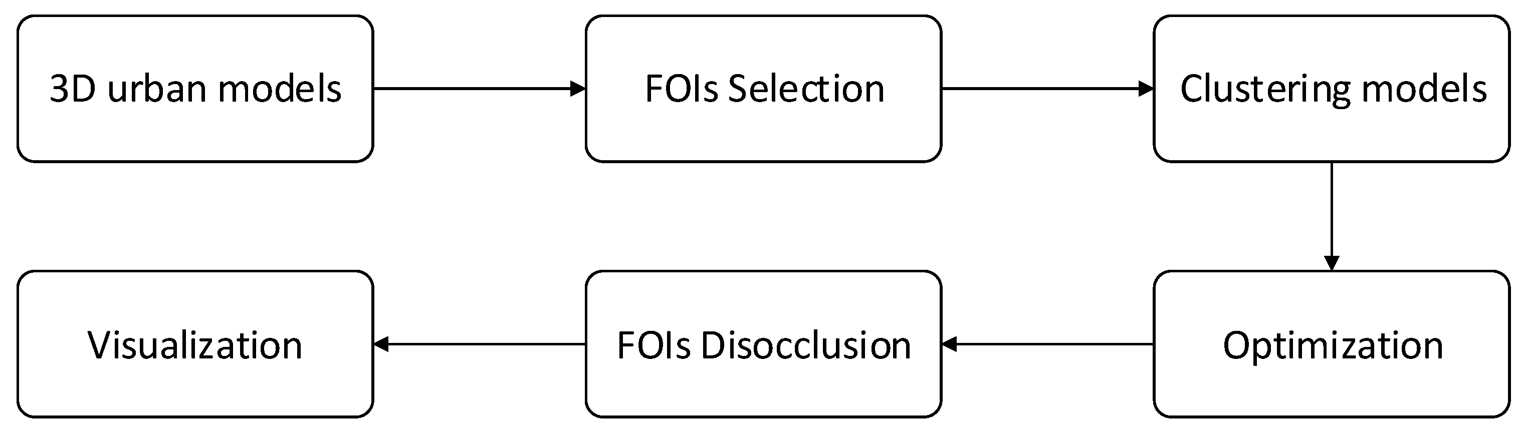
3.5. Implementation
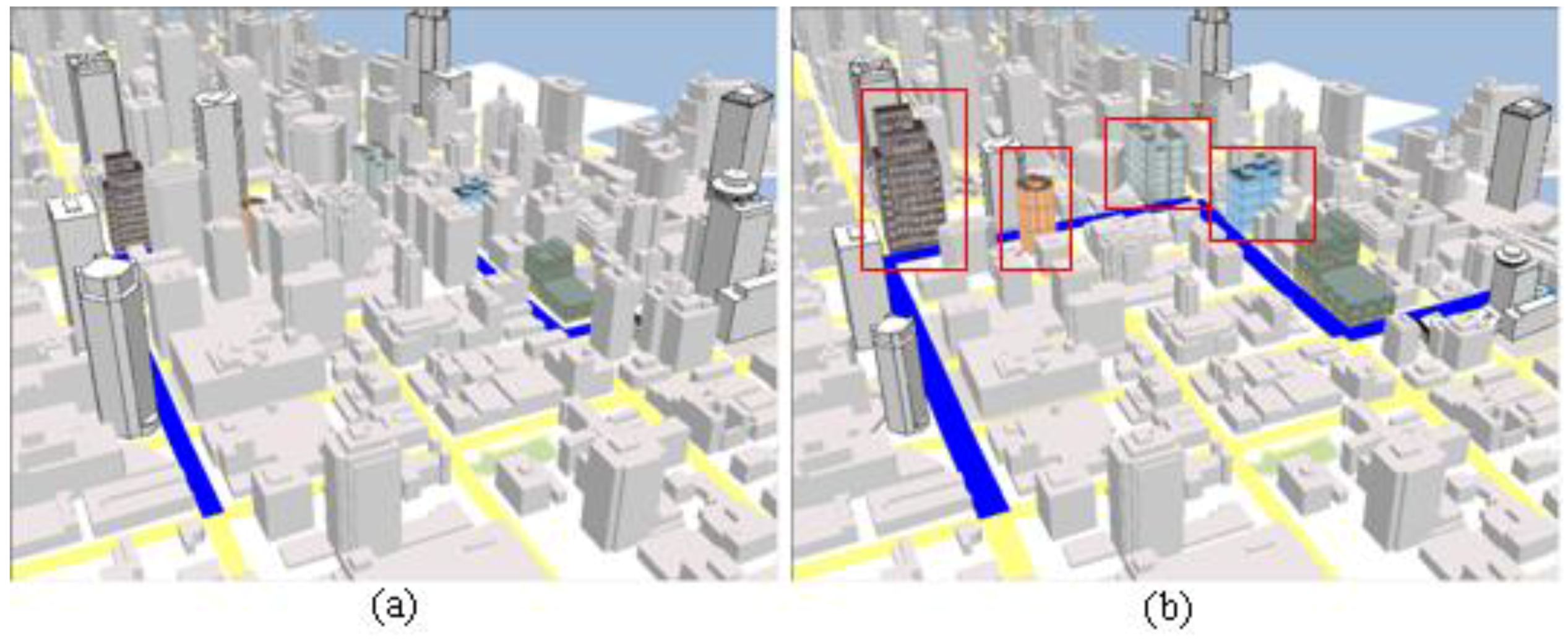
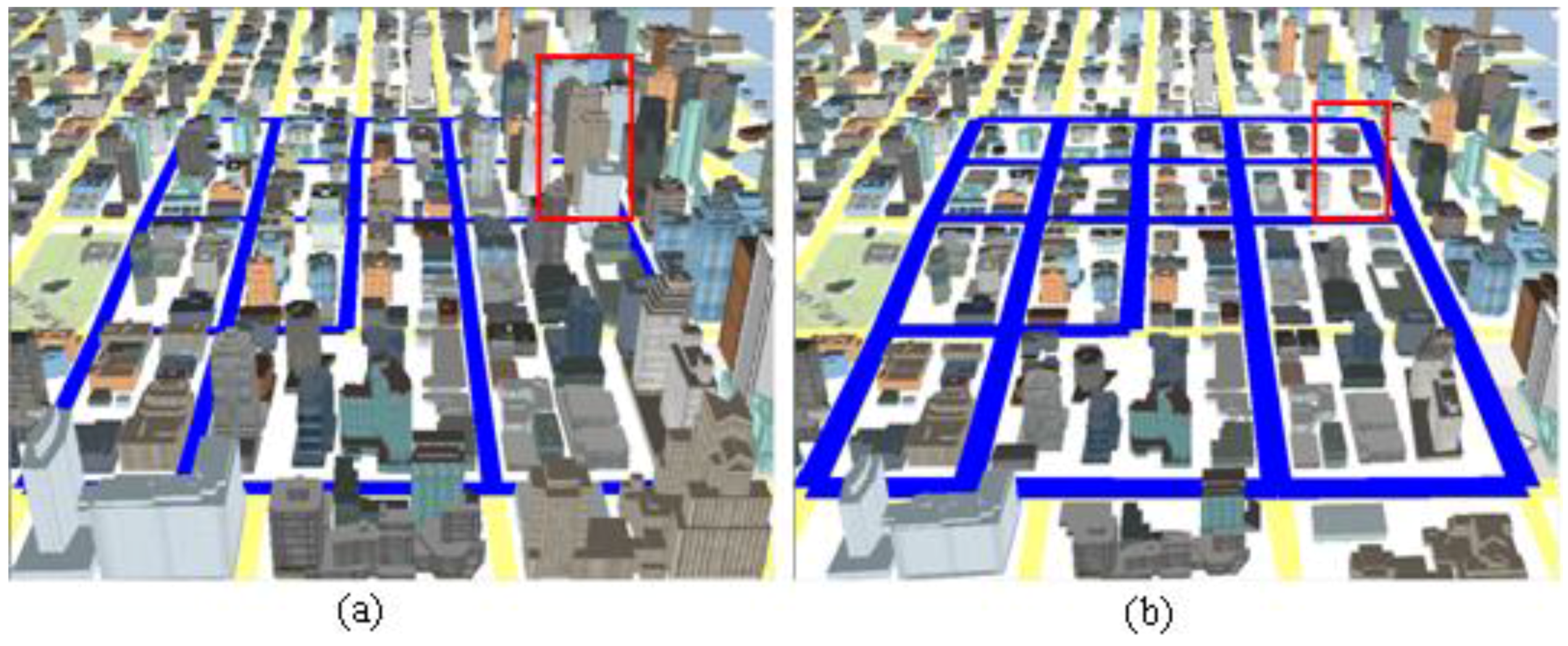
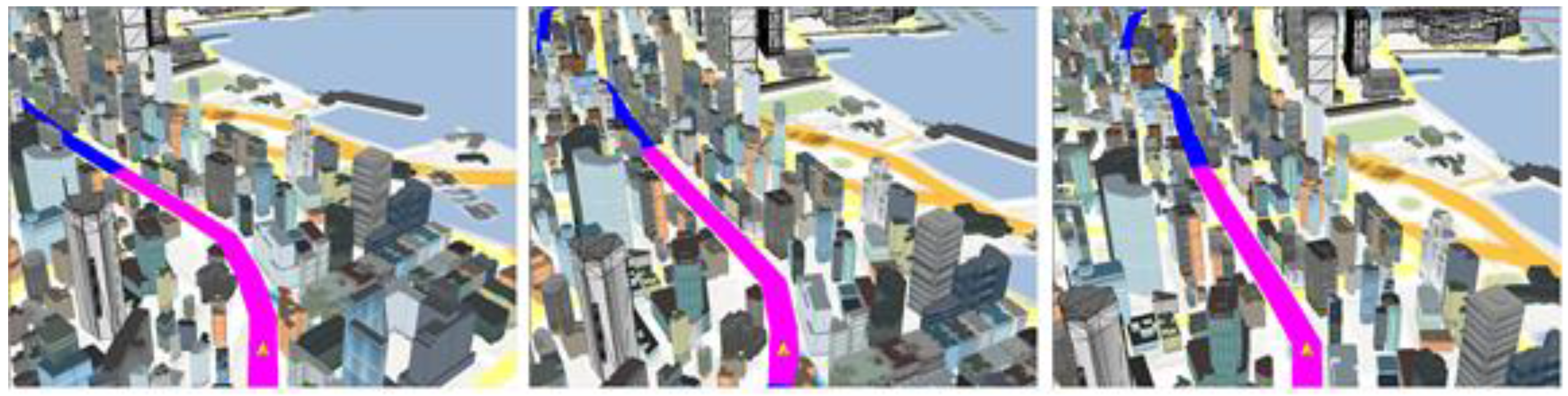
4. Experimental Results
4.1. Study Data
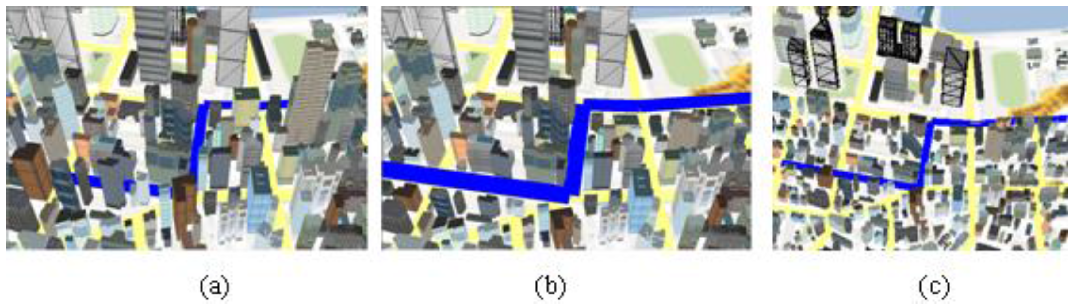
4.2. Result
4.3. Performance
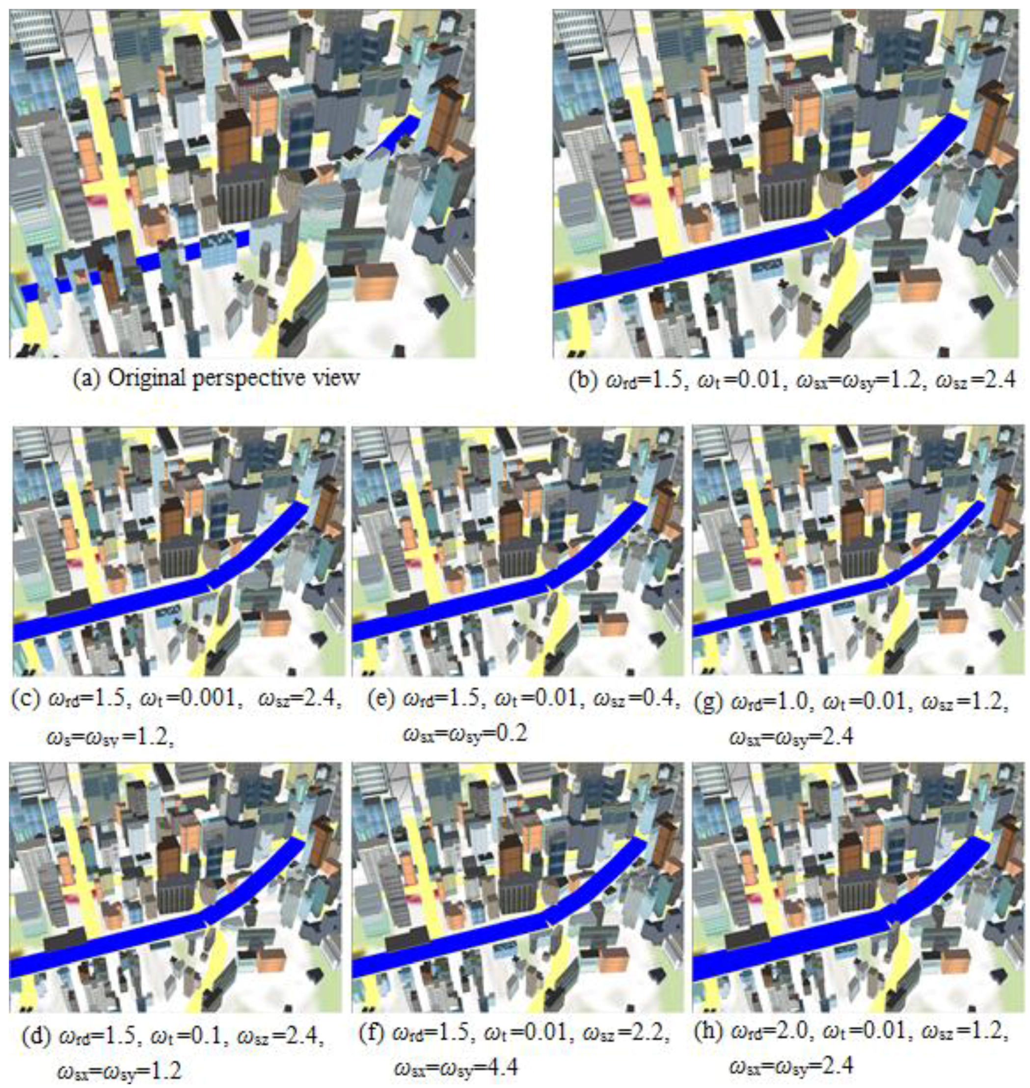
4.4. Weight Adjustment
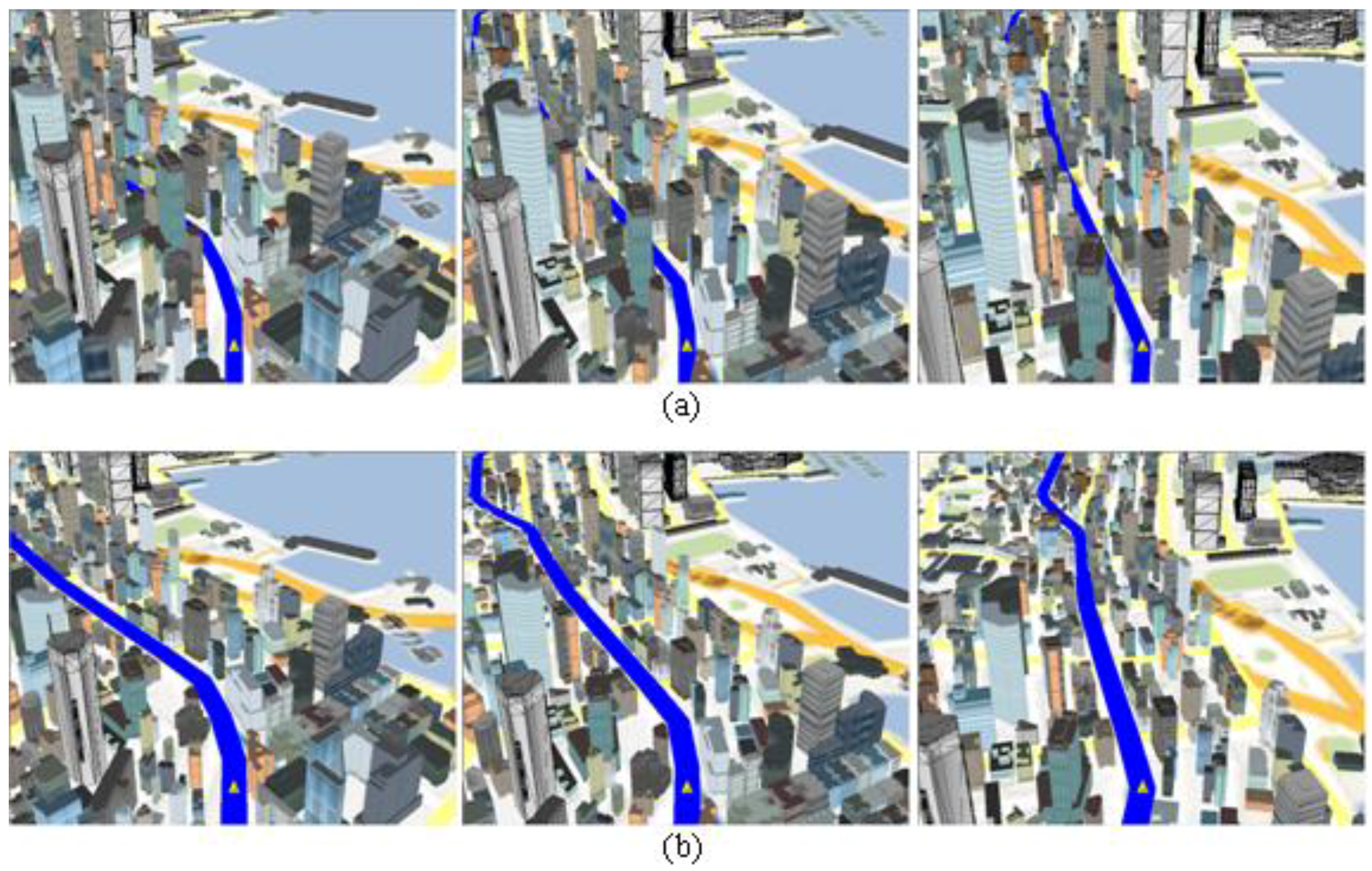
5. User Study
6. Conclusions
Acknowledgments
Author Contributions
Conflicts of Interest
References
- Hermann, F.; Bieber, G.; Duesterhoeft, A. Egocentric maps on mobile devices. In Proceedings of International Workshop on Mobile Computing, Monpellier, France, 21–22 July 2003.
- Degener, P.; Schnabel, R.; Schwartz, C.; Klein, R. Effective visualization of short routes. IEEE Trans. Vis. Comput. Graph. 2008, 14, 1452–1458. [Google Scholar] [PubMed]
- Lu, Y.; Liu, Y. Pervasive location acquisition technologies: Opportunities and challenges for geospatial studies. Comput. Environ. Urban Syst. 2012, 36, 105–108. [Google Scholar] [CrossRef]
- Presson, C.C. The development of map-reading skills. Child Dev. 1982, 53, 196–199. [Google Scholar] [CrossRef] [PubMed]
- Hirono, D.; Wu, H.; Arikawa, M.; Takahashi, S. Constrained optimization for disoccluding geographic landmarks in 3d urban maps. In Proceedings of the 6th IEEE Pacific Visualization Symposium (PacificVis 2013), Sydney, Australia, 26 February–1 March 2013; pp. 17–24.
- Buchroithner, M. True-3D in Cartography: Autostereoscopic and Solid Visualisation of Geodata; Springer: Berlin, Germany, 2012. [Google Scholar]
- Zhang, L.; Deng, H.; Chen, D.; Wang, Z. A spatial cognition-based urban building clustering approach and its applications. Int. J. Geogr. Inf. Sci. 2013, 27, 721–740. [Google Scholar]
- Rosen, P.; Popescu, V. An evaluation of 3D scene exploration using a multiperspective image framework. Vis. Comput. 2011, 27, 623–632. [Google Scholar] [CrossRef] [PubMed]
- Takahashi, S.; Yoshida, K.; Shimada, K.; Nishita, T. Occlusion-Free Animation of Driving Routes for Car Navigation Systems. IEEE Trans. Vis. Comput. Graph. 2006, 12, 1141–1148. [Google Scholar] [CrossRef] [PubMed]
- Carpendale, S.; Ligh, J.; Pattison, E. Achieving higher magnification in context. ed. In Proceedings of the 17th Annual ACM Symposium on User Interface Software and Technology, Santa Fe, NM, USA, 24–27 October 2004; pp. 71–80.
- Möser, S.; Degener, P.; Wahl, R.; Klein, R. Context aware terrain visualization for wayfinding and navigation. Comput. Graph. Forum 2009, 27, 1853–1860. [Google Scholar] [CrossRef]
- Takahashi, S.; Ohta, N.; Nakamura, H.; Takeshima, Y.; Fujishiro, I. Modeling Surperspective Projection of Landscapes for Geographical Guide-Map Generation. Comput. Graph. Forum 2002, 21, 259–268. [Google Scholar] [CrossRef]
- Grabler, F.; Agrawala, M.; Sumner, R.W.; Pauly, M. Automatic generation of tourist maps. ACM Trans. Graph. 2008, 27, 3. [Google Scholar] [CrossRef]
- Degener, P.; Klein, R. A variational approach for automatic generation of panoramic maps. ACM Trans. Graph. 2009, 28, 1–14. [Google Scholar] [CrossRef]
- Glander, T.; Döllner, J. Automated cell based generalization of virtual 3D city models with dynamic landmark highlighting. In Proceedings of 11th ICA Workshop on Generalization and Multiple Representation, Monpellier, France, 20–21 June 2008.
- Glander, T.; Döllner, J. Abstract representations for interactive visualization of virtual 3D city models. Comput. Environ. Urban Syst. 2009, 33, 375–387. [Google Scholar] [CrossRef]
- Cui, J.; Rosen, P.; Popescu, V.; Hoffmann, C. A curved ray camera for handling occlusions through continuous multiperspective visualization. IEEE Trans. Vis. Comput. Graph. 2010, 16, 1235–1242. [Google Scholar] [PubMed]
- Deng, H.; Zhang, L.; Mao, X.; Qu, H. Interactive urban context-aware visualization via multiple disocclusion operators. IEEE Trans. Vis. Comput. Graph. 2016, 22, 1862–1874. [Google Scholar] [CrossRef] [PubMed]
- Qu, H.; Wang, H.; Cui, W.; Wu, Y.; Chan, M.-Y. Focus+ context route zooming and information overlay in 3D urban environments. IEEE Trans. Vis. Comput. Graph. 2009, 15, 1547–1554. [Google Scholar] [PubMed]
- Dibiase, D.; MacEachren, A.M.; Krygier, J.B.; Reeves, C. Animation and the role of map design in scientific visualization. Cartogr. Geogr. Inf. Sci. 1992, 19, 201–214. [Google Scholar] [CrossRef]
- Deng, H.; Zhang, L.; Han, C.; Ren, Y.; Zhang, L.; Li, J. Efficient occlusion-free visualization for navigation in mountainous areas. Comput. Geosci. 2013, 52, 389–397. [Google Scholar] [CrossRef]
- Li, Z.; Yan, H.; Ai, T.; Chen, J. Automated building generalization based on urban morphology and Gestalt theory. Int. J. Geogr. Inf. Sci. 2004, 18, 513–534. [Google Scholar] [CrossRef]
- Nan, L.; Sharf, A.; Xie, K.; Wong, T.-T.; Deussen, O.; Cohen-Or, D.; Chen, B. Conjoining Gestalt rules for abstraction of architectural drawings. ACM Trans. Graph. 2011, 30, 185. [Google Scholar] [CrossRef]
- Patricios, N.N. Urban design principles of the original neighbourhood concepts. Urban Morphol. 2002, 6, 21–32. [Google Scholar]
- Regnauld, N. August. Recognition of building clusters for generalization. In Proceedings of the 7th International Symposium on Spatial Data Handling, Delft, the Netherlands, 12–16 August 1996; Volume 1, pp. 185–198.
- Press, W.H.; Teukolsky, S.A.; Vetterling, W.T.; Flannery, B.P. Numerical Recipes in C: The Art of Scientific Computing (Second Edition); Cambridge University England EPress: Cambridge, UK, 1992. [Google Scholar]
- Wang, Z.; Zhang, L.; Fang, T.; Mathiopoulos, T.; Tong, X.; Qu, H.; Xiao, Z.; Li, F.; Chen, D. A Multiscale and Hierarchical Feature Extraction Method for Terrestrial Laser Scanning Point Cloud Classification. IEEE Trans. Geosci. Remote Sens. 2015, 53, 2409–2425. [Google Scholar] [CrossRef]


| Figures | Max. Scale_x | Max. Scale_y | Max. Scale_z |
|---|---|---|---|
| Figure 8 | 0.953 | 0.797 | 0.302 |
| Figure 9 | 0.712 | 0.824 | 0.269 |
| Figure 10 | 0.736 | 0.801 | 0.325 |
| Figure 11 | 0.627 | 0.745 | 0.125 |
| Figures | The Total Occlusion Measurement Value | The Total Deviation Measurement Value |
|---|---|---|
| Figure 1 | 1127.8 | 1854.9 |
| Figure 8 | 1201.3 | 1984.1 |
| Figure 9 | 1236.6 | 1991.4 |
| Figure 10 | 1382.9 | 2011.2 |
| Figure 11 | 1514.7 | 2179.1 |
| Figure | #{Occ.} | #{Rd} | Opt. Time | FPS0 | FPS |
|---|---|---|---|---|---|
| Figure 1. | 40–85 | 21 | 116–303 | 21.5–28.3 | 10.1–6.4 |
| Figure 7. | 33 | 7 | 113 | 28.8 | 12.7 |
| Figure 8. | 108 | 26 | 343 | 27.5 | 7.6 |
| Figure 9. | 22 | 8 | 287 | 9.8 | 7.7 |
| Figure 10. | 108 | 40 | 1007 | 10.3 | 5.2 |
| Example | 1 | 2 | 3 | 4 | 5 | 6 |
|---|---|---|---|---|---|---|
| Time (CP) | 74.1 s | 49.8 s | 98 s | 105 s | 109 s | 239 s |
| Acc. (CP) | 83.3% | 80.0% | 85.7% | 83.3% | 77.8% | 70.0% |
| Time (OF) | 36.3 s | 26.1 s | 52.8 s | 61.5 s | 69.9 s | 92.7 s |
| Acc. (OF) | 100% | 87.5% | 90.9% | 81.8% | 87.5% | 88.9% |
| Time (FC) | 45.3 s | 40.0 s | 79.5 s | 76.5 s | 77.8 s | 133 s |
| Acc. (FC) | 87.5% | 88.9% | 88.9% | 80.0% | 80.0% | 75.0% |
© 2016 by the authors; licensee MDPI, Basel, Switzerland. This article is an open access article distributed under the terms and conditions of the Creative Commons Attribution (CC-BY) license (http://creativecommons.org/licenses/by/4.0/).
Share and Cite
Zhang, L.; Zhang, L.; Xu, X. Occlusion-Free Visualization of Important Geographic Features in 3D Urban Environments. ISPRS Int. J. Geo-Inf. 2016, 5, 138. https://doi.org/10.3390/ijgi5080138
Zhang L, Zhang L, Xu X. Occlusion-Free Visualization of Important Geographic Features in 3D Urban Environments. ISPRS International Journal of Geo-Information. 2016; 5(8):138. https://doi.org/10.3390/ijgi5080138
Chicago/Turabian StyleZhang, Liang, Liqiang Zhang, and Xiang Xu. 2016. "Occlusion-Free Visualization of Important Geographic Features in 3D Urban Environments" ISPRS International Journal of Geo-Information 5, no. 8: 138. https://doi.org/10.3390/ijgi5080138
APA StyleZhang, L., Zhang, L., & Xu, X. (2016). Occlusion-Free Visualization of Important Geographic Features in 3D Urban Environments. ISPRS International Journal of Geo-Information, 5(8), 138. https://doi.org/10.3390/ijgi5080138