
A Spatial Data Infrastructure Integrating Multisource Heterogeneous Geospatial Data and Time Series: A Study Case in Agriculture

 ,
,  ,
,  and
and
Abstract
:
1. Introduction
2. Current Issues in GD Sharing and Management on the Web
- -
- Legislation and new strategies entered into force with the European Directive 2007/2/EC known as INSPIRE [6] which defines a complex legislative framework for the establishment of an INfrastructure for SPatial InfoRmation in Europe to improve usability of GD to support environmental protection and sustainable development policies. Another Directive 2003/98/EC, known as the 'PSI Directive', focuses on the economic aspects of the re-use of information and it encourages Member States to make as much information available for reuse as possible [15]. European Commission also supports Open data initiative, which refers to the idea that datasets created with the support of public funding should be freely available for use, and more precisely re-use [20]. The Commission's work is focusing on generating value through re-use of a specific type of data—public sector data, and government data. Another area, which has recently gained high interest by the European political scene, is related to exploiting Big Data [21] for supporting and accelerating the transition towards a data-driven economy. The data-driven economy will stimulate research and innovation on data while leading to more business opportunities and to increased availability of knowledge and capital, in particular for SMEs, across Europe.
- -
- Standardization activities of both the World Wide Consortium (W3C) [22] and the Open Geospatial Consortium (OGC) [23] who announced, at the beginning of 2015, a new collaboration to improve interoperability and integration of GD on the Web. GD describing geographic locations on Earth and natural and anthropic features significantly enriches location-based consumer services, online maps, news, scientific research, government administration, and many other applications. OGC standards support interoperable solutions for the Geo-Web, wireless and location-based services, and mainstream IT “geo-enabled” applications. Bridging GIS systems and the Web will create a network effect that enriches both worlds.
- -
- Increasing trend of available free and open software can significantly facilitate GD handling processes. Open software is perhaps the most well-known aspect of open GIS. Indeed, open source software is one of the methodological driving forces behind the paradigm of open science [24].
- -
- Decreasing trend of market prices for hardware resources can also favor investments: nowadays, a computer, which would be sufficient to deploy a GD node on the Internet from a medium research institute, can be purchased at low cost.
3. Spatial Data Infrastructure Design
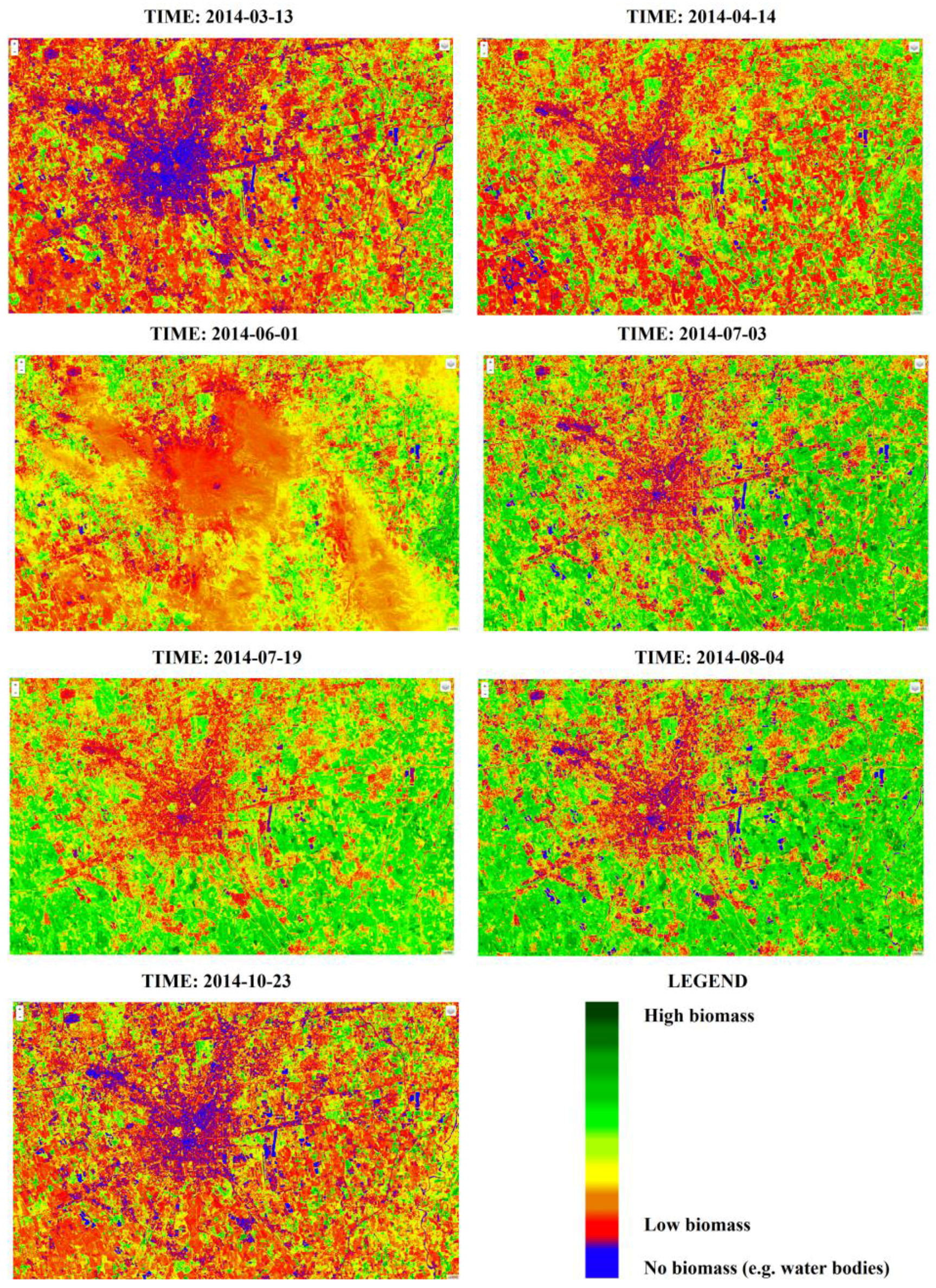
- space, i.e., time series of multispectral satellite images for monitoring crop conditions and crop growing;
- aero, i.e., one/few image(s) acquired by drones for monitoring crop conditions at the local scale for precision agriculture applications and/or to further investigate anomalous condition identified by satellite analysis; and
- in-Situ, i.e., time series of data from automatic (i.e., meteo stations) and human sensors such as periodic observations from authoritative field operators (i.e., agronomists, Lombardy Region experts) or volunteers (i.e., citizens or farmers) equipped with a smart applications. These in-situ data are dynamically joined to official GD derived from both the Lombardy Region agronomic database “Sistema Informativo Agronomico Regione Lombardia” (SIARL), [27] and the cadastral database.
- automatically listing all available DG and time series published timely on the SDI without the need of accessing the catalogue to retrieve them;
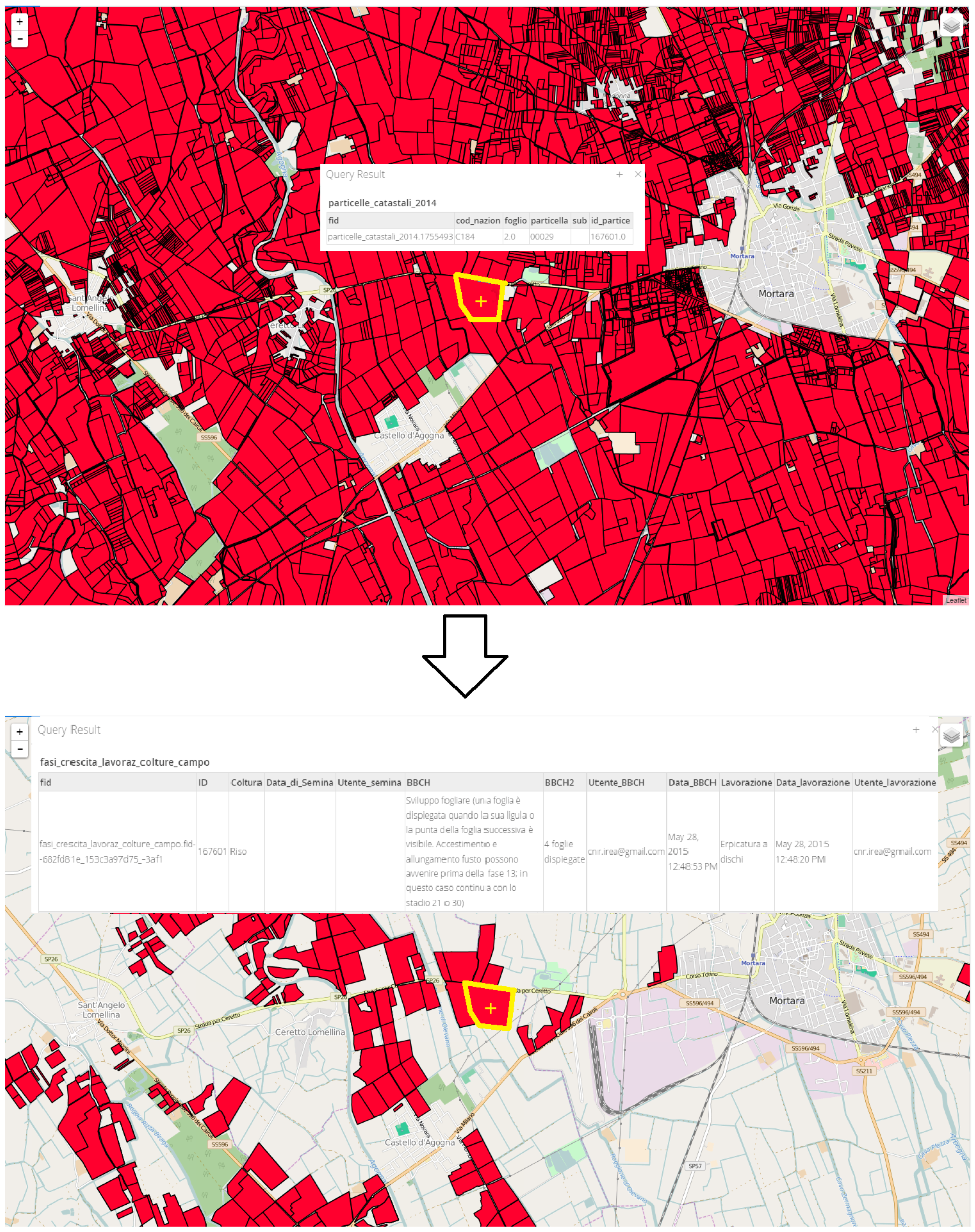
- spatially exploring the active GD layers and time series such as the ability to spatially query multiple heterogeneous and multisource active layers with a single query;
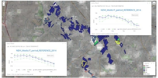
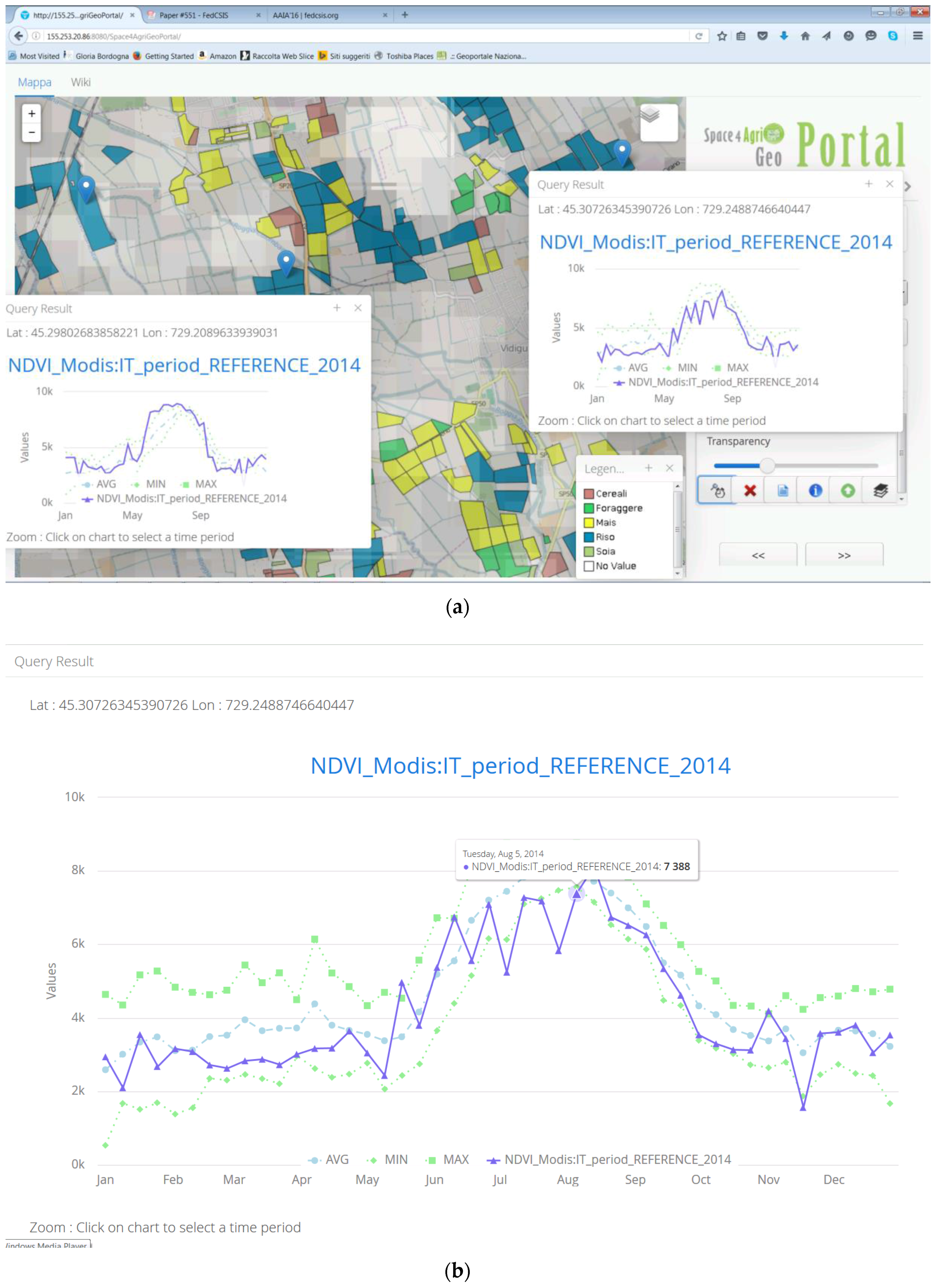
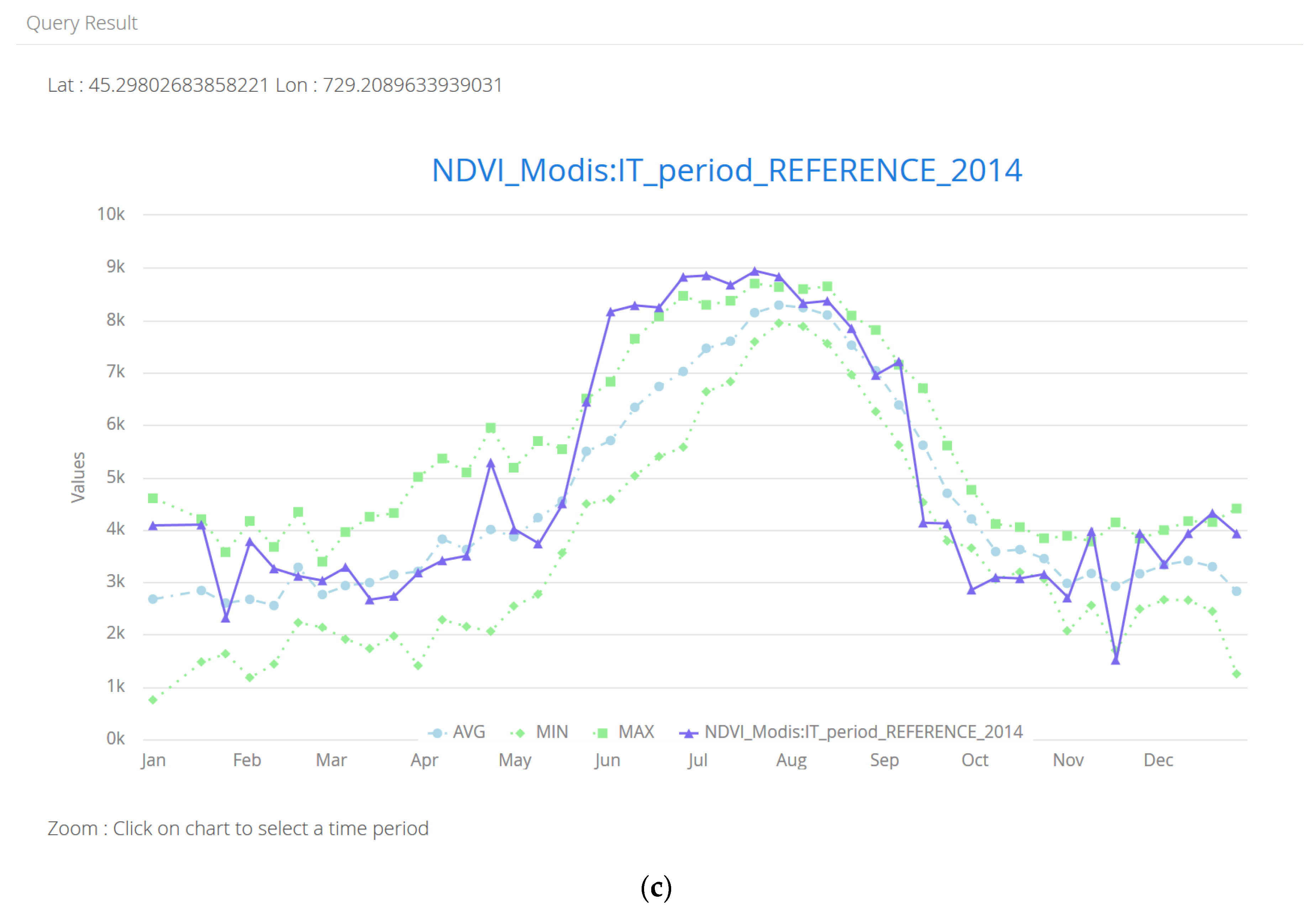
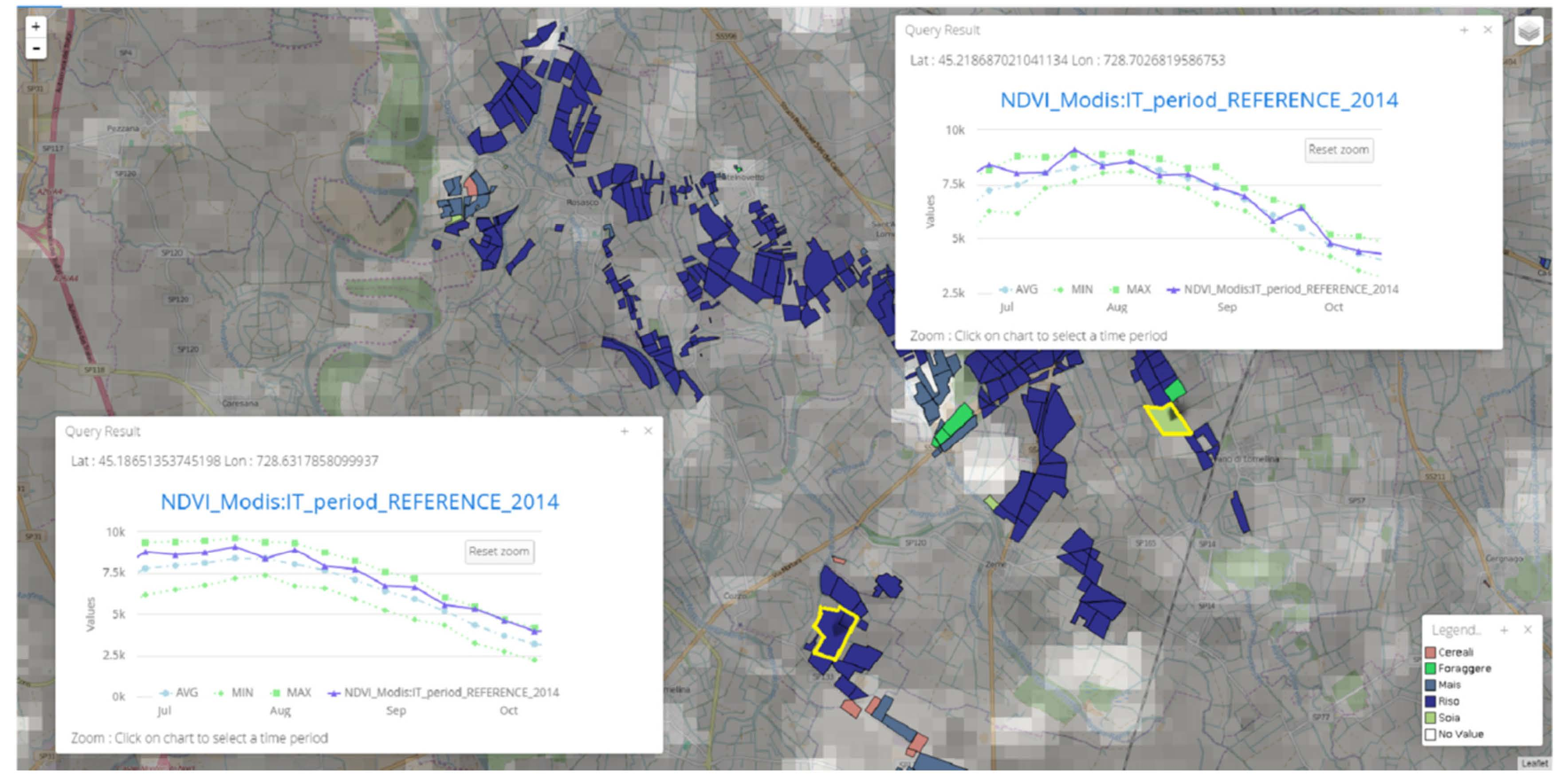
- analyzing and producing diagrams of the GD time series trend in time and space so as to be able to enhance local anomalies and correlations with other heterogonous multisource GD; and
- performing the discovery of S4A GD sets and time series to understand their semantics and quality through a link to the geo-catalogue service.
4. SDI Components
4.1. GD Sets and Time Series
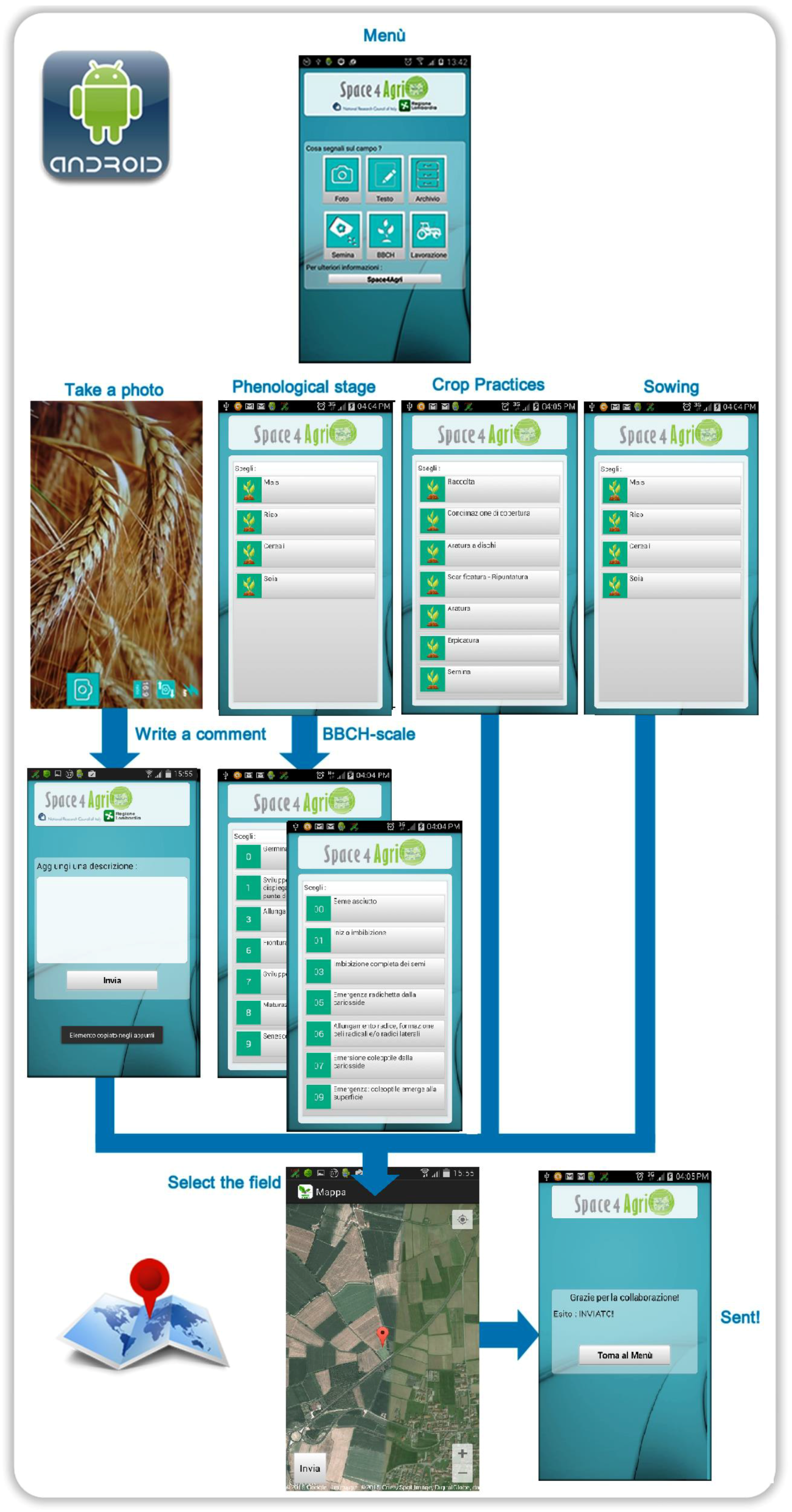
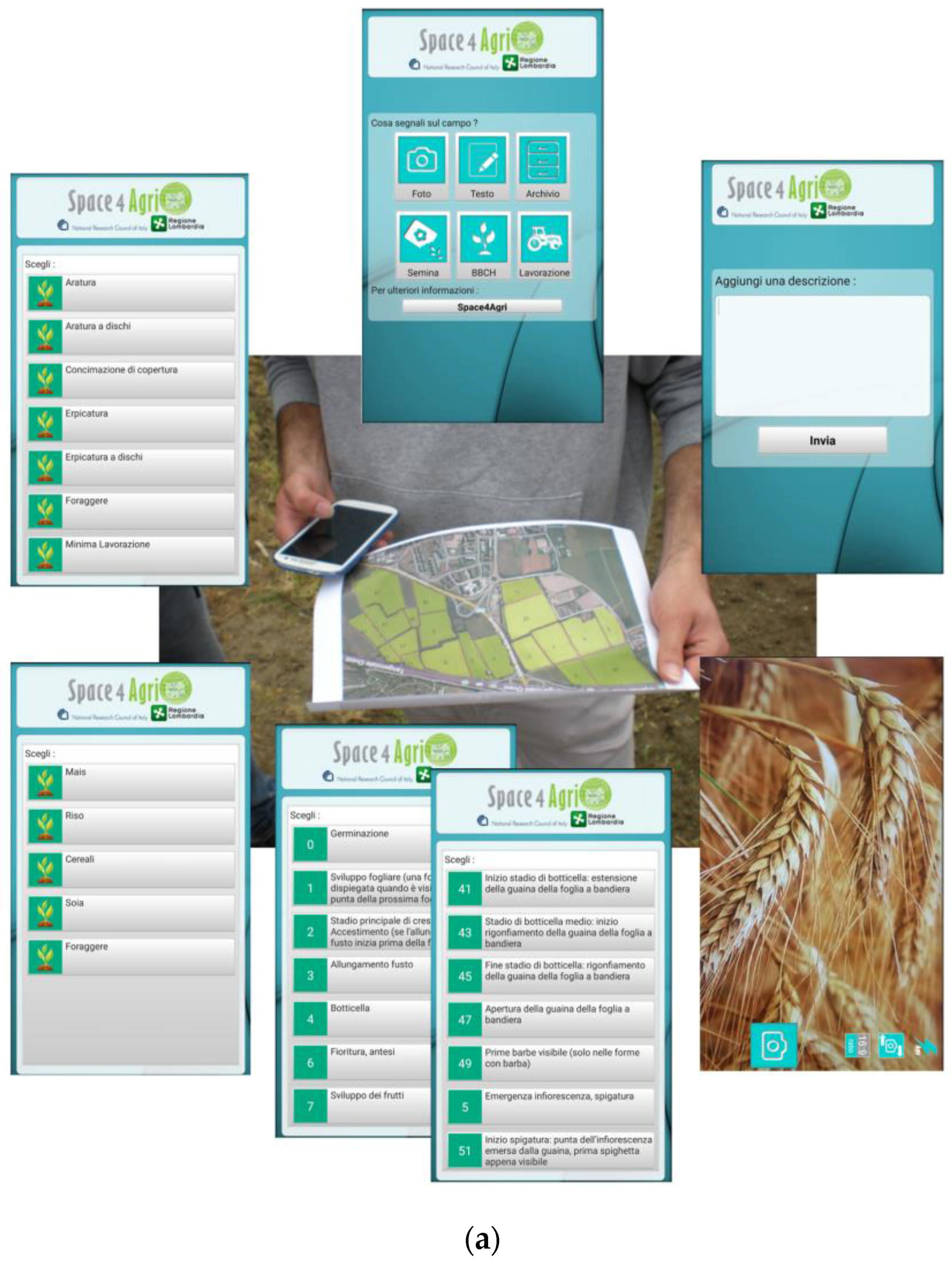
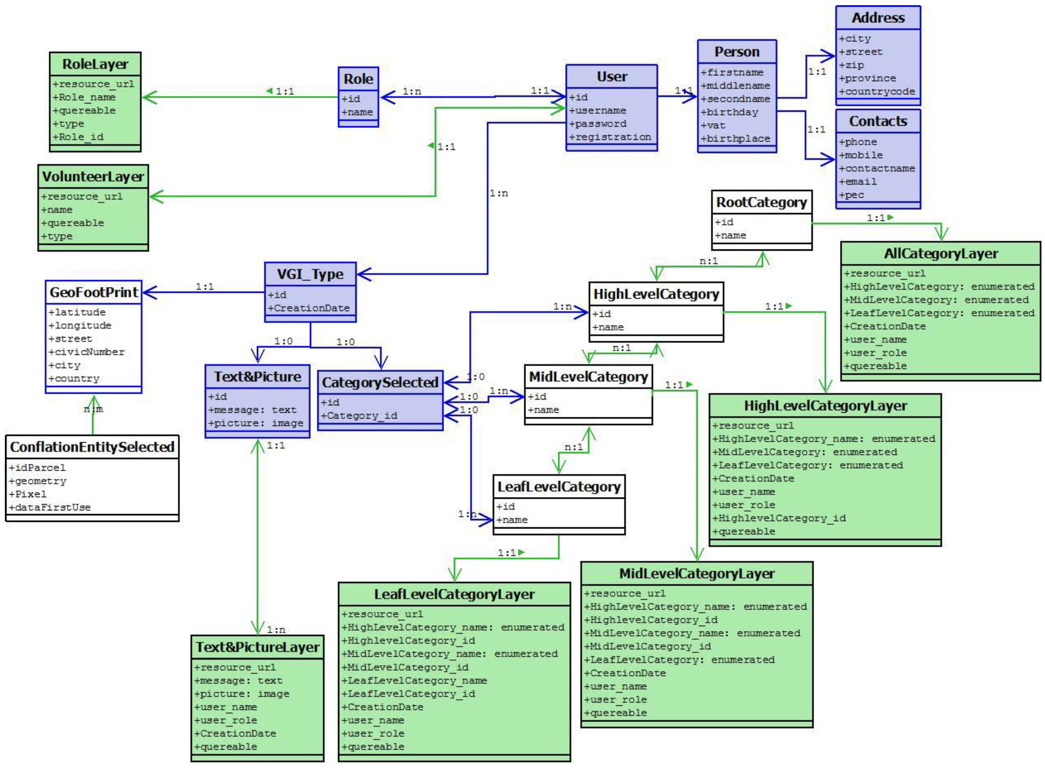
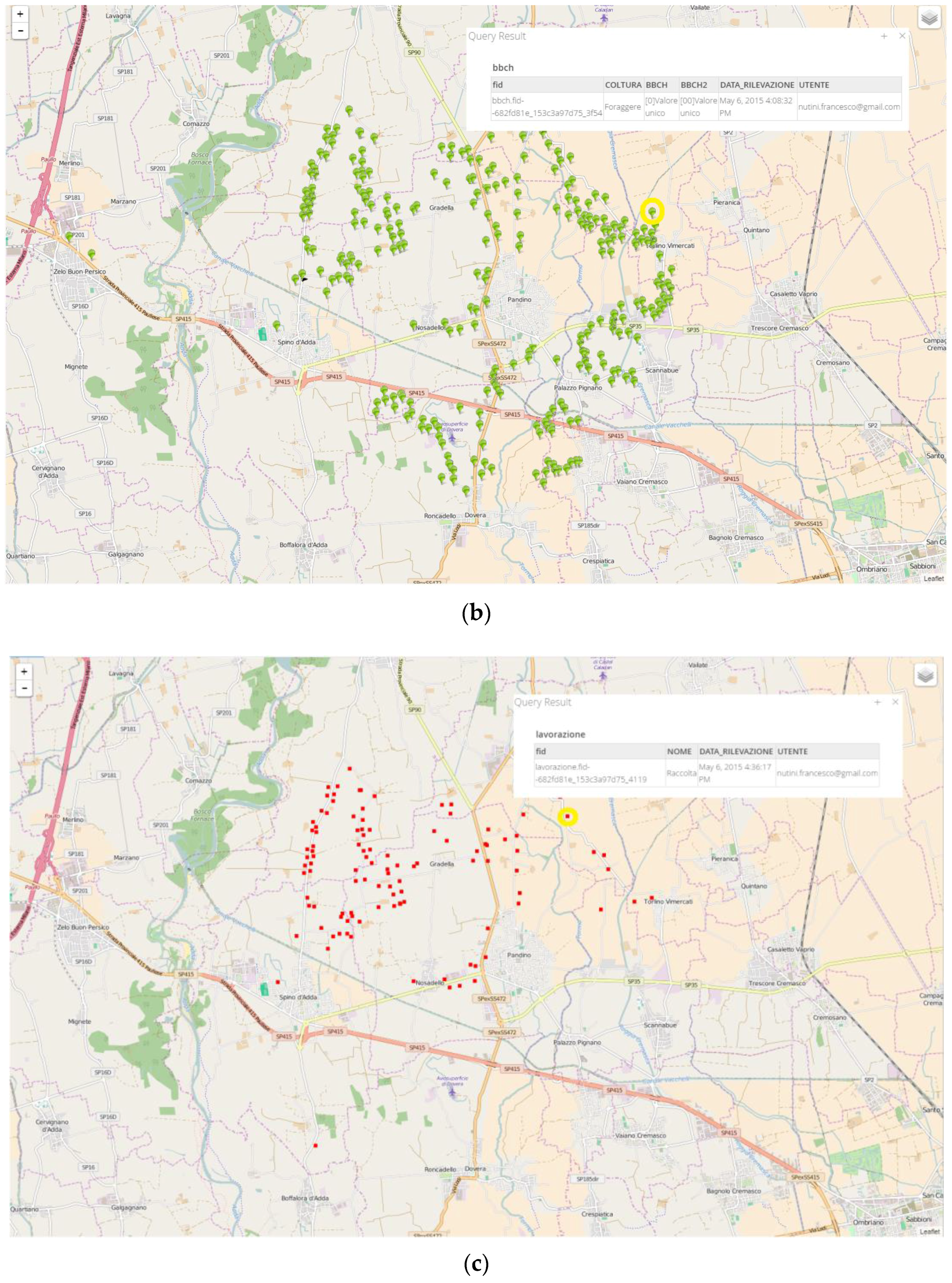
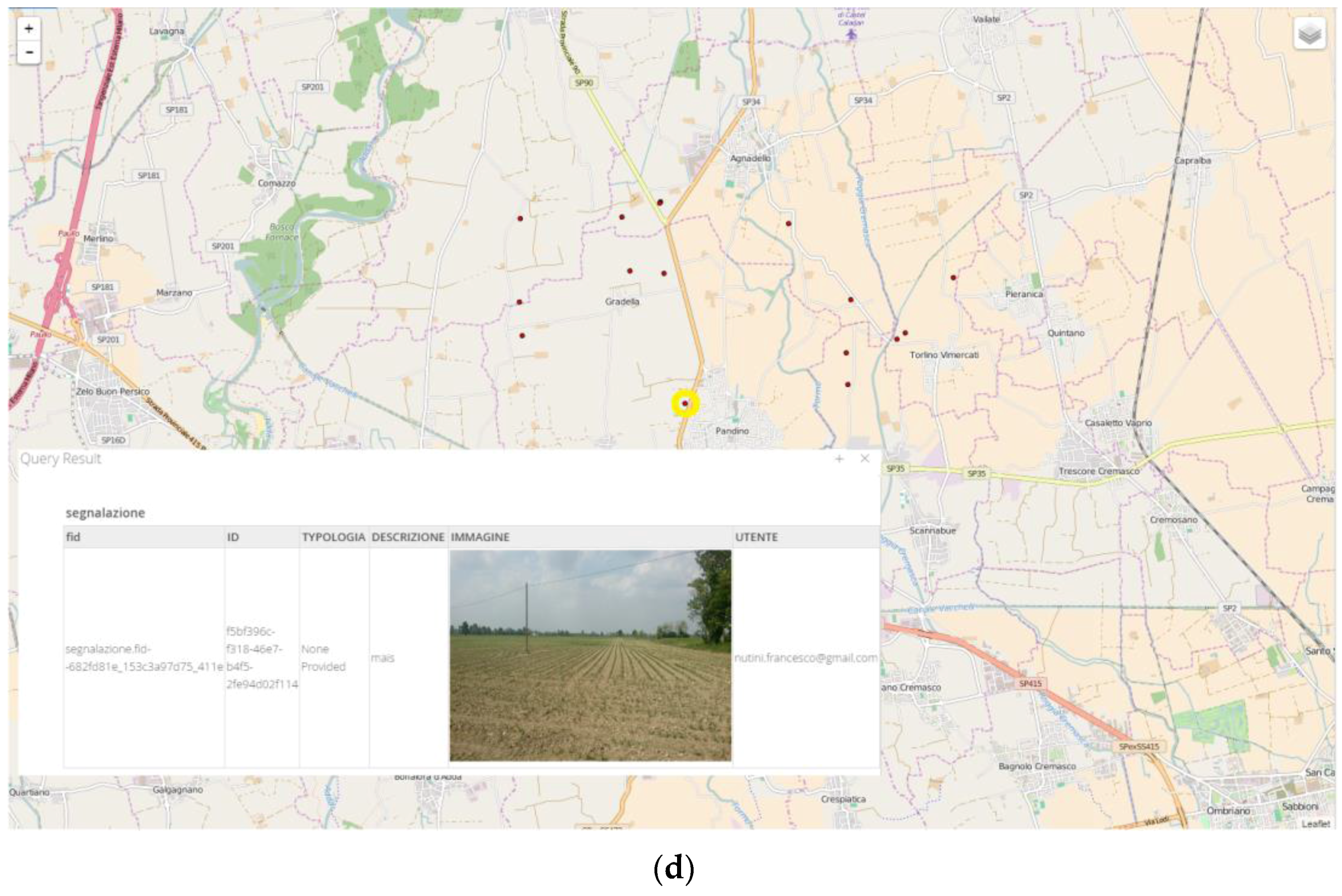
4.2. The Smart APP for Creating VGI Reports
- The possibility to support data normalization and semantic interoperability by providing a domain ontology to the user in order to ease both the creation of observations and the interpretation of contents by potential stakeholders. The user can describe the observed objects by selecting tags from a set of pre-defined categories and sub-categories whose meaning is provided in the form of both a textual description and a visual prototype, such as a picture of an object representing the category.
- The OGC standard Web deploy of the created VGI and correspondent metadata so as to be able to discover it by content queries and to correlate it with other georeferenced information from other sources and with distinct format and semantic.
- The resolution of geometric imprecision of the VGI footprints by the application of georeferenced conflation techniques, so as to eliminate redundancy and inconsistencies by fusing VGI items created within the boundary or close to the boundary of the same entities of interest.
4.3. SDI Services for GD Sets, Time Series and Metatada Web Deploy
4.3.1. Publishing Remote Sensing Images
4.3.2. Publishing in-Situ Observations
4.3.3. Publishing Authoritative Data from Regional Agricultural Database
4.3.4. Publishing Metadata
4.4. SDI Discovery and Analysis Access Points
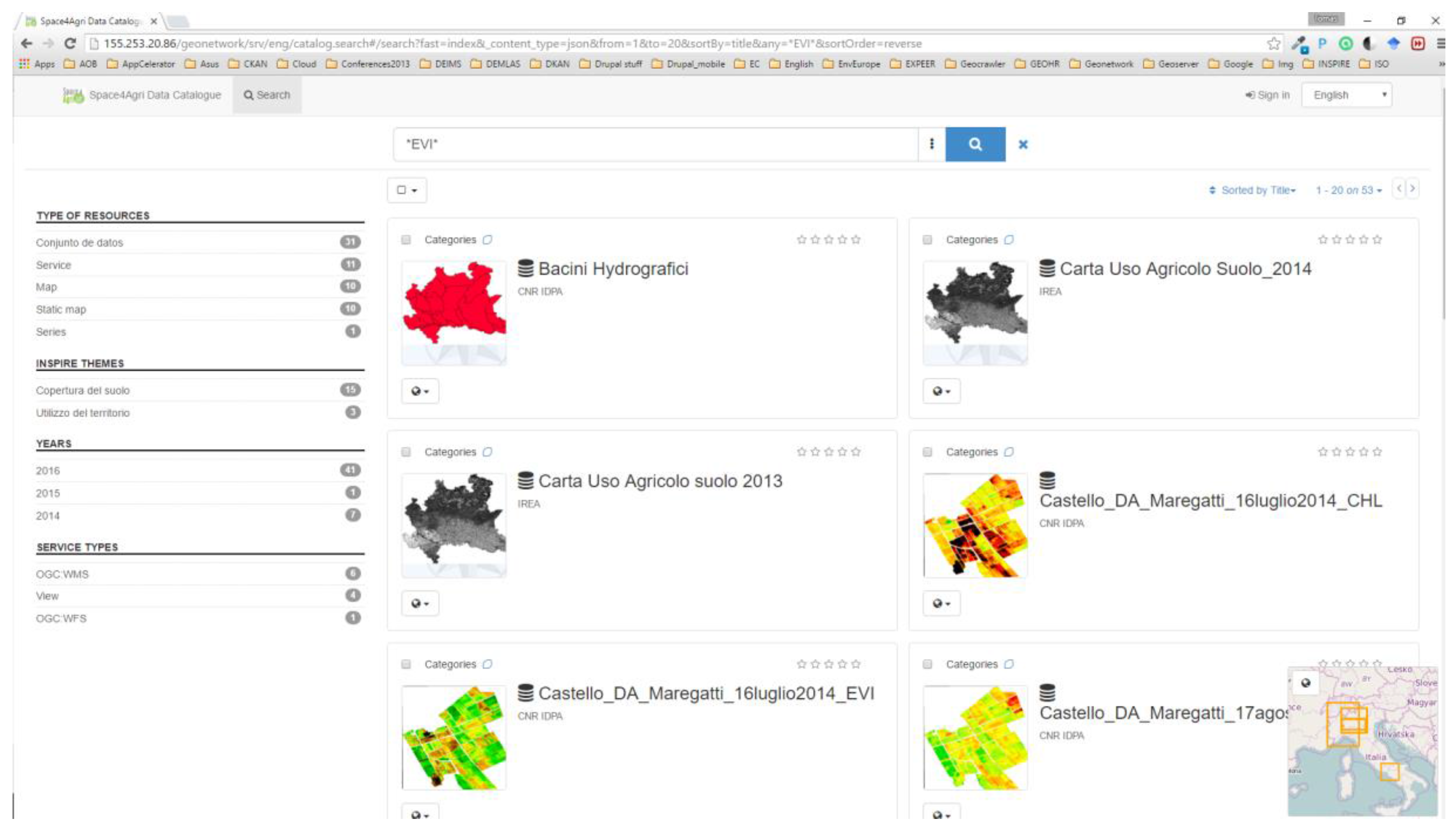
- the GeoNetwork catalogue service which allows discovering the GD of interest by specifying queries to retrieve the metadata and consequently the correspondent GD (the S4A geo-catalogue sevice is available at [46]);
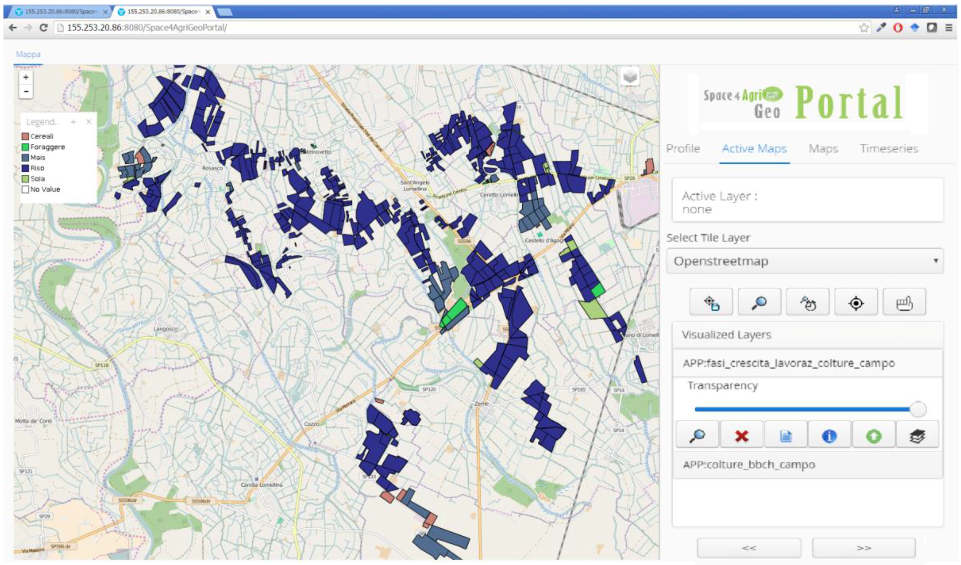
- the S4A project’s customizable geoportal which automatically provides the list of all available GD layers and time series in a menu from which the user can select and perform spatio temporal queries (the S4A geo-catalogue sevice is available at [47]).
4.4.1. The Catalogue Service Access Point
4.4.2. The Customizable Geoportal Access Point
5. Related Works
6. Conclusions and Future Works
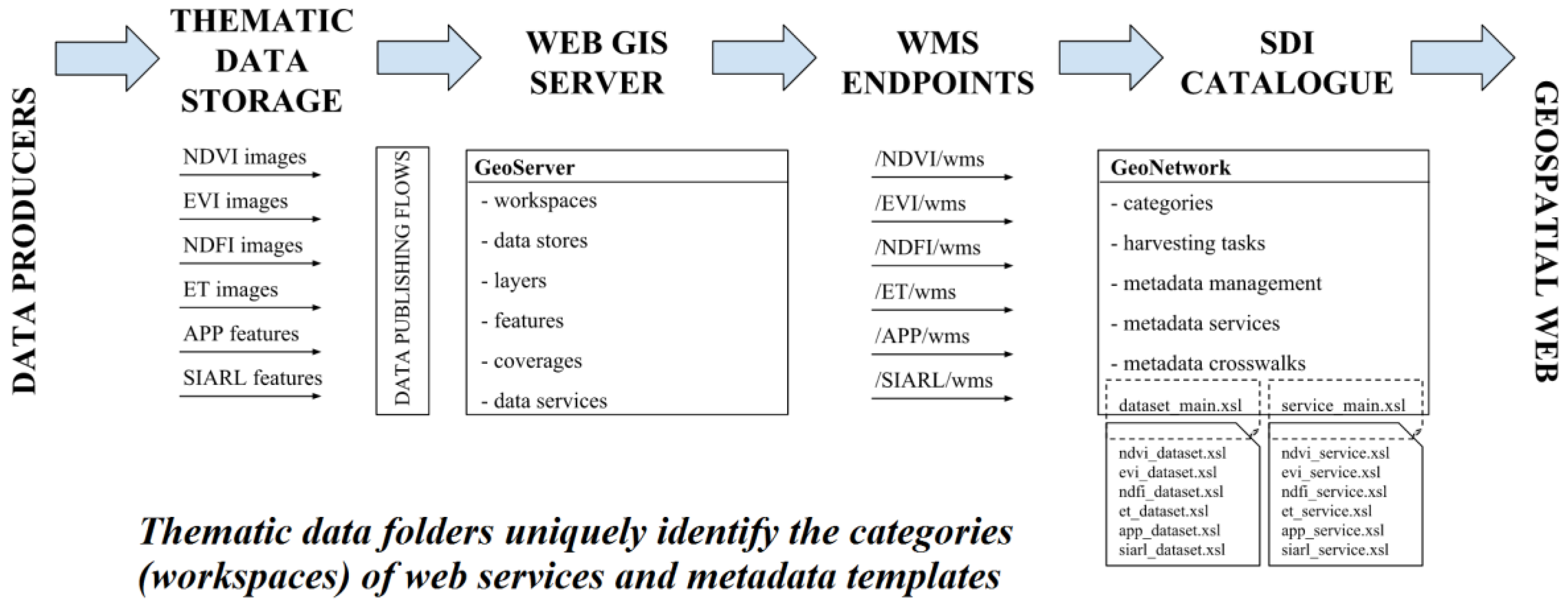
- It is scalable, since it decentralizes the publishing of GD sets and time series on several Web GIS server nodes depending on their information sources, so that new nodes can be added as new sources or more GD to deploy become available.
- Its implementation is low cost since it is mainly implemented on OGC standard open software, namely Geoserver nodes installations for GD deploy and Geonetwork for metadata management, running in virtual machines deployed on “low-cost” work stations with 16 GB of memory, 1 TB of disk space, four core CPU and price below 1000 EUR.
- It is fully compliant with OGC standards so that the deployed GD can be discovered and accessed by third party OCG compliant clients.
- It preserves current daily habits of data producers so as to minimize the additional burden for metadata handling by automating the workflows for the deployment of heterogeneous multisource GD sets and time series and for metadata completion. The only task that is required to data producers is to tag the GD sets and time series to be published by placing them in appropriate folders, whose structure and naming conventions is defined by them, and to keep the comprehensive template metadata record updated in each folder.
- It provides complex spatial analysis functions developed by orchestrating standard Web services to ease current workflows of spatial analysis which require the user to be aware of the GD formats and structure.
Acknowledgments
Author Contributions
Conflicts of Interest
Abbreviations
| APP | Smart Application for Smart mobile devices |
| GD | Geospatial Data, i.e., Georeferenced geographic data in the form or vector maps orf georeferenced images |
| GIS | Geographic Information System |
| IREA | Institute for the Electromagnetic Sensing of the Environment |
| NDVI | Normalized Difference Vegetation Index |
| OGC | Open Geospatial Consortium |
| SDI | Spatial Data Infrastructure |
| VGI | Volunteered Geographic Information |
| WFS | Web Feature Service |
| WMS | Web Map Service |
| WMS-T | Web Map Service-Time |
References
- Scharl, A.; Tochtermann, K. (Eds.) The Geospatial Web: How Geobrowsers, Social Software and the Web 2.0 are Shaping the Network Society; Springer: London, UK, 2007.
- Sanderson, M.; Kohler, J. Analyzing geographic queries. In Proceedings of the 2004 Workshop on Geographic Information Retrieval SIGIR, Sheffield, UK, 25–29 July 2004.
- Tuma, A.; Ahmad, A. Geographic information system and spatial data infrastructure: A developing societies’ perception. Univ. J. Geosci. 2014, 2, 85–92. [Google Scholar]
- Goodchild, M.F. Citizens as sensors: The world of volunteered geography. GeoJournal 2007, 69, 211–221. [Google Scholar] [CrossRef]
- Craglia, M.; Goodchild, M.F.; Annoni, A.; Camara, G.; Gould, M.; Kuhn, W.; Mark, D.; Masser, I.; Maguir, D.; Eliang, S.; et al. Next-generation digital earth: A position paper from the vespucci initiative for the advancement geographic information science. Int. J. Spat. Data Infrastruct. Res. 2008, 3, 146–167. [Google Scholar]
- The European Parliament and the Council of the European Union. Directive 2007/2/EC of the European Parliament and of the Council of 14 March establishing an Infrastructure for Spatial Information in the European Community (INSPIRE). Available online: http://eur-lex.europa.eu/legal-content/EN/ALL/?uri=CELEX:32007L0002 (accessed on 10 October 2014).
- Trilles, S.; Díaz, L.; Gil, J.; Huerta, J. Assisted generation and publication of geospatial metadata. In Proceedings of the 15th AGILE International Conference on Geographic Information Science: Bridging the Geographic Information Sciences, Avignon, France, 24–26 April 2012; pp. 105–110.
- Díaz, L.; Martín, C.; Gould, M.; Granell, C.; Manso, M.A. Semi-automatic metadata extraction from imagery and cartographic data. In Proceedings of the IEEE International Geoscience and Remote Sensing Symposium, Barcelona, Spain, 23–28 July 2007; pp. 3051–3052.
- Nogueras-Iso, J.; Zarazaga-Soria, F.J.; MuroMedrano, P.R. Geographic information metadata for spatial data infrastructures. Resour. Interoper. Inf. Retr. 2005. [Google Scholar] [CrossRef]
- Olfat, H. Automatic Spatial Metadata Updating and Enrichment. Master’s Thesis, The University of Melbourne, Melbourne, Vic, Australia, 2013. [Google Scholar]
- Diaz, L.; Granell, C.; Huerta, J.; Gould, M. Web 2.0 Broker, A standards-based service for spatio-temporal search of crowd-sourced information. Appl. Geogr. 2012, 35, 448–459. [Google Scholar] [CrossRef]
- Pebesma, E. Spacetime: Spatio-temporal data in R. J. Stat. Softw. 2012, 51, 1–30. [Google Scholar] [CrossRef]
- Rigaux, P.; Scholl, M.; Voisard, A. Spatial Databases with Applications to GIS; Morgan Kaufmann Publisher: Burlington, MA, USA, 2002. [Google Scholar]
- Villa, P.; Reitz, T.; Gomarasca, M. The HUMBOLDT project: Implementing a framework for geo-spatial data harmonization and moving towards an ESDI. In GeoInformation in Europe; Gomarsca, M.A., Ed.; IOS Press: Amsterdam, The Netherlands, 2007; pp. 29–36. [Google Scholar]
- The European Parliament and the Council of the European Union: Directive 2003/98/EC of the European Parliament and of the Council of 17 November 2003 on the re-use of public sector information. Available online: http://eur-lex.europa.eu/LexUriServ/LexUriServ.do?uri=OJ:L:2003:345:0090:0096:en:PDF (accessed on 10 October 2014).
- SmartOpenData. Available online: http://www.smartopendata.eu/ (accessed on 10 October 2014).
- Smart Open Data. SDI4Apps Developers Blog. Available online: http://www.smartopendata.eu/news/sdi4apps-developers-blog (accessed on 10 October 2014).
- OpenGeo. Available online: http://suite.opengeo.org/dashboard/ (accessed on 10 October 2014).
- OSGeo community. Available online: http://www.osgeo.org/ (accessed on 10 October 2014).
- Zuiderwijk, A.; Janssen, M. Open data policies, their implementation and impact: A framework for comparison. Gov. Inf. Q. 2014, 31, 17–29. [Google Scholar] [CrossRef]
- Mayer-Schönberger, V.; Cukier, K. Big Data: A Revolution That will Transform How We Live, Work, and Think; Houghton Mifflin Harcourt: Boston, MA, USA, 2013. [Google Scholar]
- Jaffe, J. Web at 25, W3C at 20: An opportunity to reflect and look to the future. IEEE Internet Comput. 2014, 18, 74–78. [Google Scholar] [CrossRef]
- Béjar, R.; Lopez-Pellicer, F.J.; Nogueras-Iso, J.; ZarazagaSoria, F.J.; Muro-Medrano, P.R. A protocol for machinereadable cache policies in OGC web services: Application to the EuroGeoSource information system. Environ. Model. Softw. 2014, 60, 346–356. [Google Scholar] [CrossRef]
- Sui, D. Opportunities and impediments for open GIS. Trans. GIS 2014, 18, 1–24. [Google Scholar] [CrossRef]
- Ivánová, I.; Morales, J.; de By, R.A.; Beshe, T.S.; Gebresilassie, M.A. Searching for spatial data resources by fitness for use. J. Spat. Sci. 2013, 58, 15–28. [Google Scholar] [CrossRef]
- Space4Agri Project. Available online: http://space4agri.irea.cnr.it/it (accessed on 12 May 2016).
- Kliment, T.; Bordogna, G.; Frigerio, L.; Stroppiana, D.; Crema, A.; Boschetti, M.; Sterlacchini, S.; Brivio, P.A. Supporting a regional agricultural sector with Geo & mainstream ICT—The case study of space4agri project. Agris Online Pap. Econ. Inform. 2014, 6, 69–80. [Google Scholar]
- PostGreSQL. Available online: http://www.postgresql.org (accessed on 12 May 2016).
- PostGIS. Available online: http://www.postgresql.org/ (accessed on 12 May 2016).
- GeoServer. Available online: http://geoserver.org/ (accessed on 12 May 2016).
- GeoNetwork. Available online: http://www.geonetwork.it (accessed on 12 May 2016).
- QGIS. Available online: http://www.qgis.org (accessed on 12 May 2016).
- Rouse, J.W.; Haas, R.H.; Schell, J.A.; Deering, D.W. Monitoring vegetation systems in the Great Plains with ERTS. In Proceedings of the Third Earth Resources Technology Satellite-1 Symposium, Washington, DC, USA, 10–14 December 1973; pp. 309–317.
- Huete, A.R.; Liu, H.; Batchily, K.; van Leeuwen, W. A comparison of vegetation indices over a global set of TM images for EOS-MODIS. Remote Sens. Environ. 1997, 59, 440–451. [Google Scholar] [CrossRef]
- Gamon, J.A.; Surfus, J.S. Assessing leaf pigment content and activity with a reflectometer. New Phytol. 1999, 143, 105–117. [Google Scholar] [CrossRef]
- Boschetti, M.; Nutini, F.; Manfron, G.; Brivio, P.A.; Nelson, A. Comparative analysis of normalised difference spectral indices derived from MODIS for detecting surface water in flooded rice cropping systems. PLoS ONE 2014, 9, e88741. [Google Scholar] [CrossRef] [PubMed]
- Bordogna, G.; Kliment, T.; Frigerio, L.; Carrara, P. Volunteered geographic information and spatial data infrastructures to promote s-low resources: The case study of the “Orti di Bergamo” smart application. In Centrality of Territories; Casti, E., Burini, F., Eds.; Sestante Edizioni Publisher: Bergamo, Italy, 2015; pp. 165–182. [Google Scholar]
- BBCH Ontology Definition. Available online: http://wiki.plantontology.org/index.php/Growth_Stages_Ontology_Principles (accessed on 10 October 2014).
- Fugazza, C.; Basoni, A.; Menegon, S.; Oggioni, A.; Pavesi, F.; Pepe, M.; Sarretta, A.; Carrara, P. RITMARE: Semantics aware harmonisation of data in Italian marine research. Procedia Comput. Sci. 2014, 33, 261–265. [Google Scholar] [CrossRef]
- Voges, U.; Senkler, K. OpenGIS Catalogue Services Specification 2.0. 2-ISO Metadata Application Profile; OGC Document Ref. Number OGC07-006r1; Open Open Geospatial Consortium (OGC): Wayland, MA, USA, 2007. [Google Scholar]
- Whiteside, A. OGC Web Services Common Specification; Open Geospatial Consortium (OGC): Wayland, MA, USA, 2007. [Google Scholar]
- ESRI Shapefile Technical Description: An ESRI White Paper—July 1998. Available online: https://www.esri.com/library/whitepapers/pdfs/shapefile.pdf (accessed on 12 May 2016).
- Open Street Map Project. Available online: http://www.openstreetmap.org (accessed on 12 May 2016).
- Ticheler, J.; Hielkema, J.U. Geonetwork opensource internationally standardized distributed spatial information management. OSGeo J. 2007, 2, 1–6. [Google Scholar]
- Zhou, D.P.; Xie, K.L. Lucene search engine. Comput. Eng. 2007, 33, 95–96. [Google Scholar]
- Space4Agri Project Geo-Catalogue service. Available online: http://155.253.20.86/geonetwork/srv/eng/catalog.search (accessed on 12 May 2016).
- Space4Agri Project Geo-portal. Available online: http://155.253.20.86:8080/Space4AgriGeoPortal/ (accessed on 12 May 2016).
- Villa, P.; Stroppiana, D.; Fontanelli, G.; Azar, R.; Brivio, P.A. In-season mapping of crop type with optical and X-band SAR data: A classification tree approach using synoptic seasonal features. Remote Sens. 2015, 7, 12859–12886. [Google Scholar] [CrossRef]
- Craglia, M.; De Bie, K.; Jackson, D.; Pesaresi, M.; Remetey-Fülöpp, G.; Wang, C.; Annoni, A.; Bian, L.; Campbell, F.; Ehlers, M.; et al. Digital Earth 2020: Towards the vision for the next decade. Int. J. Digit. Earth 2012, 5, 4–21. [Google Scholar] [CrossRef]
- Vaccari, L.; Shvaiko, P.; Marchese, M. A geo-service semantic integration in spatial data infrastructures. Int. J. Spat. Data Infrastruct. Res. 2009, 4, 24–51. [Google Scholar]
- Yue, P.; Gong, J.; Di, L.; He, L. Automatic geospatial metadata generation for earth science virtual data products. Geoinformatica 2012, 16, 1–29. [Google Scholar] [CrossRef]
- Vockner, B.; Richter, A.; Mittlböck, M. From geoportals to geographic knowledge portals. ISPRS Int. J. Geo-Inf. 2013, 2, 256–275. [Google Scholar] [CrossRef]
- Salajegheh, J.; Hakimpou, F.; Esmaeily, A. Developing a web-based system by integrating VGI and SDI for real estate management and marketing. Int. J. Arch. Photogramm. Remote Sens. Spat. Inf. Sci. 2014, 40, 231–236. [Google Scholar] [CrossRef]
- Clerici, M.; Combal, B.; Pekel, J.F.; Dubois, G.; van’t Klooster, J.; Skøien, J.O.; Bartholomé, E. The eStation, an earth observation processing service in support to ecological monitoring. Ecol. Inform. 2013, 18, 162–170. [Google Scholar] [CrossRef]
- Honda, K.; Ines, A.V.M.; Yui, A. Agriculture information service built on geospatial data infrastructure and crop modelling. In Proceedings of the 2014 International Workshop on Web Intelligence and Smart Sensing, Saint Etienne, France, 1–2 September 2014.
- L’Astorina, A.; Tomasoni, I.; Basoni, A.; Carrara, P. Commentary beyond the dissemination of earth observation research: Stakeholders’ and users’ involvement in project co-design. J. Sci. Commun. 2015, 14, 1–10. [Google Scholar]


| Legislation and new strategies | European Directive 2007/2/EC-INSPIRE- and 2003/98/EC—“PSI Directive” [6,15] |
| Standardization activities | World Wide Consortium (W3C) and Open Geospatial Consortium (OGC) recommendations for improving interoperability of GD on the Web (e.g., SmartOpenData [16] and SDI4Apps [17] projects) |
| Increasing trend of available free and open software | Open software for GD management (OpenGeo [18], OSGeo community [19]) |
| Decreasing trend of market prices for hardware resources | cloud computing services and Service-Oriented Architectures (SOA) |
<!-- ROUTING TO SPACE4AGRI NDVI WMS SERVICE—DATASET TEMPLATES --> <xsl:when test="contains(/WMT_MS_Capabilities/Service/Title,'NDVI:')"> <xsl:apply-templates select="." mode="NDVI"> <xsl:with-param name="NDVI_Name" select="$Name"/> <xsl:with-param name="NDVI_uuid" select="$uuid"/> <xsl:with-param name="NDVI_lang" select="$lang"/> <xsl:with-param name="NDVI_topic" select="$topic"/> <xsl:with-param name="NDVI_maxCRS" select="$maxCRS"/> </xsl:apply-templates> </xsl:when> <!-- ROUTING TO GEONETWORK DEFAULT WMS SERVICE TEMPLATE --> <xsl:otherwise> <xsl:apply-templates/> </xsl:otherwise> |
© 2016 by the authors; licensee MDPI, Basel, Switzerland. This article is an open access article distributed under the terms and conditions of the Creative Commons Attribution (CC-BY) license (http://creativecommons.org/licenses/by/4.0/).
Share and Cite
Bordogna, G.; Kliment, T.; Frigerio, L.; Brivio, P.A.; Crema, A.; Stroppiana, D.; Boschetti, M.; Sterlacchini, S. A Spatial Data Infrastructure Integrating Multisource Heterogeneous Geospatial Data and Time Series: A Study Case in Agriculture. ISPRS Int. J. Geo-Inf. 2016, 5, 73. https://doi.org/10.3390/ijgi5050073
Bordogna G, Kliment T, Frigerio L, Brivio PA, Crema A, Stroppiana D, Boschetti M, Sterlacchini S. A Spatial Data Infrastructure Integrating Multisource Heterogeneous Geospatial Data and Time Series: A Study Case in Agriculture. ISPRS International Journal of Geo-Information. 2016; 5(5):73. https://doi.org/10.3390/ijgi5050073
Chicago/Turabian StyleBordogna, Gloria, Tomáš Kliment, Luca Frigerio, Pietro Alessandro Brivio, Alberto Crema, Daniela Stroppiana, Mirco Boschetti, and Simone Sterlacchini. 2016. "A Spatial Data Infrastructure Integrating Multisource Heterogeneous Geospatial Data and Time Series: A Study Case in Agriculture" ISPRS International Journal of Geo-Information 5, no. 5: 73. https://doi.org/10.3390/ijgi5050073