


Extraction of Urban Road Boundary Points from Mobile Laser Scanning Data Based on Cuboid Voxel
1
School of Geomatics, Liaoning Technical University, Fuxin 123000, China
2
Collaborative Innovation Institute of Geospatial Information Service, Liaoning Technical University, Fuxin 123000, China
3
School of Mining, Liaoning Technical University, Fuxin 123000, China
*
Author to whom correspondence should be addressed.
ISPRS Int. J. Geo-Inf. 2023, 12(10), 426; https://doi.org/10.3390/ijgi12100426
Submission received: 19 July 2023
/
Revised: 27 September 2023
/
Accepted: 11 October 2023
/
Published: 16 October 2023
(This article belongs to the Topic Urban Sensing Technologies)
Abstract
:The accuracy of point cloud processing results is greatly dependent on the determination of the voxel size and shape during the point cloud voxelization process. Previous studies predominantly set voxel sizes based on point cloud density or the size of ground objects. Voxels are mostly considered square in shape by default. However, conventional square voxels are not applicable to all surfaces. This study proposes a method of using cuboid voxels to extract urban road boundary points using curb points as road boundary points. In comparison with conventional cubic voxels, cuboid voxels reduce the probability of mixed voxels at the road curb, highlight two geometric features of road curb voxels (i.e., normal vector and distribution dimension), and improve the accuracy of road curb point extraction. In this study, ground points were obtained using cloth simulation filtering. First, the cuboid-based voxelization of ground points was performed. Then, taking the voxel as a unit, two geometric features, namely, the normal vector of the voxel and the linear dimension of the point distribution in the voxel, were calculated. According to these geometric features, the voxels that met the conditions were regarded as candidate road curb voxels, and the points in them as candidate road curb points. Afterward, filtering was applied using the intensity value to eliminate the bottom points of fences, street trees, and other ground objects in the candidate road curb points. Finally, noise points were eliminated according to the clustering results of the density based spatial clustering of applications with noise (DBSCAN) algorithm. In this study, point cloud data obtained by the SSW vehicle-mounted mobile mapping system and three-point cloud datasets in the IQmulus & TerraMobilita competition dataset were used to experimentally extract road curbs. Results showed that this method could effectively extract road curb points as the precision of the four groups of data results was over 90% and the quality coefficient reached over 75%.
1. Introduction
With the emergence of concepts such as “smart city” and “digital twin cities”, how to perceive the environment of urban scenes has become a booming research hotspot. Accurate information about roads, which serve as city infrastructure, is highly important for promoting traffic safety and improving people’s life quality; roads are an essential element for 3D digital urban model reconstruction [1,2].
The traditional urban road surveying and updating (i.e., field exploration) relies on field work. It is performed by professional technicians, which takes significant amounts of labor and material resources; hence, it is considered a labor-intensive, time-consuming, and high-cost technology [3]. With the development of technology, mobile mapping systems (MMS) that are equipped with an optical camera are used as an alternative, and the Hough transform algorithm based on an infinite symmetric exponential filter is developed to obtain road boundaries [4]. However, the effect of this algorithm is not good for curved roads. With the emergence of deep learning, some new models, such as RoadTracer [5] and transformer road network graph detection [6], have been proposed. These models can deal with various complex types of roads. Influenced by image distortion, ambient lighting, and lack of geographical reference, road information is difficult to extract effectively. In recent years, MLS technology has developed rapidly, and the number of related publications has increased quicky. In comparison with ALS and MMS, MLS exhibits better flexibility and mobility and can collect high-density and high-precision 3D point clouds. Moreover, MLS is not easily affected by environmental factors, making it highly suitable for extracting road information efficiently in complex road environments. MLS can also be used to create and update road databases effectively. Thus, MLS has attracted widespread attention [7,8,9,10].
The MLS system generally refers to the ground vehicle-borne mobile laser scanning system, which adopts a passive scanning mode and can quickly and accurately obtain information about the road and its two sides [11]. The system is mainly composed of light detection and ranging (LiDAR), an inertial measurement unit (IMU), and a global navigation satellite system (GNSS). Specifically, LiDAR is primarily used to emit laser pulses, and the system estimates the distance from LiDAR to surface features by measuring the time difference between pulse emission echo and pulse reception echo. IMU and GNSS are used to solve the attitude and position information of LiDAR in real time [12,13].
Among the elements that constitute the urban road environment, the curb is a form of road boundary that provides auxiliary information for vehicle driving, such as a safety warning to drivers, assisted driving, and vehicle navigation, thereby ensuring driving safety and smooth traffic. When the signal received from the GNSS is weak due to the environment or for other reasons, the curb can be used as an important feature for intelligent vehicle positioning. In this study, on the basis of the MLS point cloud, road boundary points are extracted from road curb points [14,15].
The remainder of this paper is organized as follows. Section 2 summarizes the relevant literature regarding road extraction based on MLS point cloud data. Section 3 introduces the method proposed in this paper. Section 4 shows the experiments, in which road curb points were experimentally extracted using the data acquired by the SSW vehicle-mounted MMS and IQmulus & TerraMobilita competition data, and the experimental results are analyzed. In Section 5, conclusions are drawn.
2. Relevant Works
The existing methods for extracting road curb points based on vehicle-mounted point clouds can be divided into four categories: scanning line-based method, point cloud rasterization, machine learning, and point cloud voxelization.
Scanning line-based methods extract road curb points through the spatial geometric features of the road curb in combination with multiple constraints on the basis of scanning line regularization. Yang et al. [16] extracted road curb points by using the characteristics of elevation and angle step on the single-beam scanning line. Huang et al. [17] used the point cloud density characteristics of road curb points for extraction. The scanning line-based method is characterized by its high precision and high efficiency. The successful extraction of scanning lines is the cornerstone of this method. The division of point cloud data, which is difficult to be regularized into scanning lines, can be divided into blocks according to the distance or time based on the vehicle trajectory data, and such blocks are projected onto a local plane one by one to establish the pseudo scanning lines. Guan et al. [18] divided the point cloud into equidistant blocks based on trajectory data to realize vertical projection rasterization, then extracted the main points to form pseudo scanning lines. The above method effectively avoids the limitation of scanning lines (i.e., difficulty in extraction); however, this is realized based on driving trajectory data with poor universality.
Point cloud rasterization, a common method of point cloud data processing, projects the point cloud into a characteristic raster image, based on which an image processing algorithm is used to extract road boundaries, given that the boundaries are generally linear or curved. Classical methods, such as Hough transform [19] and line segment detector [20], can detect linear roads but cannot effectively extract curved roads. Thus, Kumar et al. [21] introduced an active contour model for road extraction on the elevation raster image, effectively dealing with the limitations of curved roads, and successfully detected road curb points. The abovementioned edge detection method is applicable to a single road point cloud. In the case of complex auxiliary ground objects, the extraction results contain the line features of various ground objects, so complex postprocessing technology is required. For this reason, Rodríguez et al. [22] extracted road boundaries using feature constraints. Specifically, they roughly extracted road boundaries by establishing a point cloud elevation map and a density feature map according to the height difference and density constraint in the raster unit. They performed region growth, realized road connection, and optimized line features based on the rough extraction results. This method can achieve a good road boundary extraction result, but it features complex principles and large calculated quantities. The point cloud rasterization method, which has a wide scope of application, transforms point clouds from randomness to regularization and replaces the complex topology between discrete points through the simple topology inherent in the raster units. In addition, the 3D structural information of point clouds is abandoned in the rasterization process.
Machine learning-based point cloud road curb extraction is a method that has emerged over recent years. This method constructs a road sample set, inputs it into the model, automatically trains the best weight, and predicts the boundary points of the road. Varney et al. [23] created a support vector machine (SVM) model that was used to take the voxel characteristics of point clouds as the training data and predict the boundary points of the road. This method can select the key samples and eliminate a large number of redundant samples, which provides a small sample learning method with good robustness. The rapid development of the deep learning model has let it gradually replace the classical machine model [24]. Wen et al. [25] combined U-Net and convolutional neural network models to extract road boundaries, achieving good extraction results. Such models are based on image data, and the image obtained by point cloud rasterization is easily distorted. Charles et al. [26] proposed a PointNet model based on 3D discrete points, Balado et al. [27] used PointNet for semantic segmentation of road environment, and some researchers have used 3D voxels as the input and output of classifiers to propose an end-to-end 3D encoder–decoder convolutional network [28]. Machine learning models are characterized by a wide scope of application and strong automaticity, but a labeled training dataset is required, as well as a long run time. In cases where a small number of datasets are used, pseudo road boundaries can be easily generated in the prediction result, making it necessary to further enrich available datasets through data augmentation methods.
Disordered point clouds can be regularized by voxelization, which can fully utilize the spatial topological structure of point clouds. The voxel-based road curb point extraction method initially divides the point cloud into 3D grids with a fixed spatial resolution, and each 3D grid represents a voxel, which is taken as the basic processing unit to realize road curb point extraction based on geometric features. Harith et al. [29] accomplished voxel-based point cloud classification by constructing voxel descriptors. Xu et al. [30] proposed the voxel energy function to extract the candidate road curb points, as well as the least cost path model algorithm to optimize the results, but the construction of the energy function was complicated. Tran et al. [31] selected seed voxels for road surface extraction based on trajectory data and then used normal vector deviation, residual, and height difference between voxels as growth criteria to perform region growing. The effective selection of seed voxels is the key to this method. When trajectory data are missing, guaranteeing that the selected seed voxels are located on the roadway is difficult. Papon et al. [32] proposed the voxel cloud connectivity segmentation algorithm, which realizes voxel clustering according to the similarity of voxel characteristics and generates supervoxels. The main difference between voxel and supervoxel is that they are in different dimensions. Voxel is a basic unit in 3D space, similar to a pixel in 2D images. Supervoxel is the basic unit in 4D or higher-dimensional space, which is similar to voxel but can represent more information. Supervoxel generation is the process of voxel clustering. Zai et al. [33] applied supervoxels to road boundary detection and used the α-shaped and graph-cut-based energy minimization algorithm to extract road boundaries based on the self-adaptive establishment of supervoxels. To prevent the occurrence of the road curb being located outside the curb range after voxel clustering, Mi et al. [34] obtained supervoxels according to the weighted distances between each candidate point and its neighboring grids, which are calculated based on point density differences, elevation differences, and horizontal distance. They used a contracted distance strategy to further localize road curb voxels. Although supervoxel solves the problem of incomplete road boundary extraction to a certain extent, several computing resources are needed in the process of supervoxel construction, which is not suitable for large-scale road extraction.
To sum up, considering the advantages of point cloud voxelization, such as information integrity, spatial order, structural topology, robustness, and timeliness, a method of extracting road curb points using LiDAR point clouds based on cuboid voxels was proposed in this paper. This method selects a cuboid voxel for point cloud voxelization according to the spatial attribute characteristics of the curb, which can effectively reduce the number of non-curb points contained in the voxel at the curb, highlight the two geometric features (i.e., normal vector and distribution dimension), and improve the accuracy and integrity of curb point extraction. To solve the difficulty in distinguishing bar-shaped vertical ground objects with similar bottom features, such as fences and trees, from road curbs, a postprocessing method based on intensity threshold constraint was designed to avoid the false extraction of similar ground objects and improve the accuracy of road curb point extraction.
3. Methodology
On the basis of the ground points obtained by the cloth simulation filter (CSF) algorithm, the method proposed in this paper initially performs the cuboid-based voxelization of ground points. Then, candidate road curb points were extracted with the voxel as a processing unit. In this process, a voxel descriptor was constructed by calculating the geometric features of the normal vector of a voxel and the linear dimension of the point distribution in a voxel [31,35]. The voxels that satisfied the normal vector constraint and the linear dimension constraint were regarded as candidate road curb voxels, and the points in the candidate road curb voxels were correspondingly regarded as candidate road curb points. Finally, the final road curb points were determined by filtering and optimizing the candidate road curb points. This process mainly involved two aspects. First, non-road curb points, such as the bottom of fences and border trees, were eliminated from the candidate road curb points according to the reflection intensity of surface features. Second, discrete noise points were eliminated based on the clustering results of the DBSCAN algorithm. Then, the final extraction results of road curb points were obtained. Figure 1 presents the overall flowchart of the method proposed in this study.
3.1. Point Cloud Voxelization
To address the challenges posed by the large quantity and irregular distribution of point clouds, reduce the calculated quantity, and mitigate the effect on non-ground points, the original point cloud was initially filtered using the CSF algorithm to extract ground points [36], which were then voxelized according to the method in Reference [11].
Through point cloud voxelization, irregular and discrete point clouds can be stored regularly, and the topological relation between adjacent discrete points can be established. Commonly used voxels are mostly cubic voxels [37], that is, each voxel is equal in length, width, and height. According to the spatial distribution features of road curb points, cuboid voxels were used in this study to replace classical cubic voxels, as shown in Figure 2. The number of mixed voxels can be effectively reduced by using cuboid voxels suitable for the spatial distribution features of the curb (i.e., reducing non-curb points contained in the road curb voxel), which can highlight the two characteristics of the normal vector of the road curb voxel and distribution dimension of the point in the voxel as follows.
(1) The coverage area of the point cloud was determined according to the maximum and minimum coordinate values of the point cloud in the X, Y, and Z directions, being [Xmin, Xmax], [Ymin, Ymax], and [Zmin, Zmax], respectively. Therein, (Xmax, Ymax, Zmax) and (Xmin, Ymin, Zmin) denote the maximum and minimum values of the point cloud in the three directions, respectively. The number of voxels in each direction of the X-, Y-, and Z-axes obtained by point cloud voxelization is determined as follows:
where ceil() is the operation of rounding up to an integer; step_x, step_y, and step_z represent the voxel length in three directions—length, width, and height, respectively.
(2) The row, column, and vertical coding of the voxel where each point is located is calculated using Formula (2) and denoted as Ri, Ci, and Hi, respectively. For fast indexing, the row, column, and vertical coding of each voxel is weighted and summed to reduce the index coding from 3D to 1D. The coding varies from voxel to voxel, and the coding of the voxel where points within the same voxel are located remains the same.
where (Xi, Yi, Zi) represents the coordinates of the current point.
(3) The voxel containing points is labeled as 1 and recorded as an effective voxel. On the contrary, the voxel without points is labeled as 0 and recorded as an invalid voxel.
3.2. Extracting Candidate Road Curb Points
To highlight the two geometric features, namely, the normal vector of the road curb voxel and distribution dimension of the point in the voxel, the number of non-road curb points contained in the road curb voxel should be reduced, so a cuboid voxel with equal length, width, and different heights was chosen in this study. If cubic voxels are used, the voxel size is generally set as the average height of the curb. Ideally, each curb voxel contains only curb points after voxelization. This pure voxel has the following two remarkable geometric features. First, the plane fitted by its internal points is approximately perpendicular to the horizontal plane, such that the normal vector of the fitted plane is approximately perpendicular to the Z-axis. Second, the points in the voxel are distributed in the shape of a vertical plane. Based on these two geometric features, the road curb voxels can be extracted. However, the actual situation is not ideal. As shown in Figure 3b, local point clusters with the same color represent a voxel unit, which shows that a voxel that includes a curb is a mixed voxel. This mixed voxel includes the curb points distributed vertically and the roadway points and sidewalk points distributed horizontally. Therefore, the plane fitted by the points in this voxel is an inclined plane, and the angle between its normal vector and the Z-axis is an acute angle. These features are inconsistent with the characteristics of the curb voxel. Thus, the road curb voxel cannot be effectively extracted.
In this study, the probability of producing mixed voxels at the road curb could be effectively reduced by using cuboid voxels conforming to the characteristics of the road curb (Figure 3c). The mixed voxels in Figure 3c were evidently reduced more than those in Figure 3b. In case of roadway voxels, as shown in Figure 4a and Figure 5a, the internal points showed gentle trends and a horizontal planar distribution, and the included angle between the normal vector of the fitted plane and the Z-axis was relatively small. In the case of road curb voxels, as shown in Figure 4b and Figure 5b, the point in the red rectangular box in Figure 5b was located in a road curb voxel and fluctuated vertically, conforming to the linear dimensional feature. Moreover, the included angle between the normal vector of the plane obtained by fitting these points and the Z-axis tended to be 90°. Therefore, cuboid voxels were used to replace classical cubic voxels in this study to extract road curb points. In this process, two features of each valid voxel obtained after voxelization were initially calculated; one is the included angle between the normal vector of the plane obtained by plane fitting with the internal points in each voxel and the Z-axis, and the other is the linear dimension of the point distribution within the voxel. After that, the voxels meeting the feature constraints were regarded as candidate road curb voxels, and the points therein as candidate road curb points.
3.2.1. Normal Vector of Voxels
After the voxelization of the point cloud, the normal vector of each voxel was solved according to principal component analysis [38] as follows. First, the covariance matrix M of points in the voxel was established according to Formula (3), and three eigenvalues (λ1, λ2, and λ3) of the matrix M were obtained by singular value decomposition, satisfying λ1 ≥ λ2 ≥ λ3 ≥ 0. The eigenvector corresponding to the minimum eigenvalue λ3 was the normal vector of the voxel. Then, the included angle α between the normal vector of the voxel and the Z-axis was calculated. If α > Th_a, then the current voxel was an initial candidate road curb voxel where Th_a is the threshold of the included angle.
where pi is the coordinates of a point in the current voxel, k is the quantity of points contained in the current voxel, and represents the centroid of all points in the current voxel.
3.2.2. Linear Dimension of Voxels
Linear dimension, as the main feature that distinguishes the road curb from other planar and discrete ground objects, is one of the dimensional features that can be used to describe the spatial distribution of local point clouds [35]. The spatial distribution feature of points in the voxel could be judged by the three eigenvalues (λ1, λ2, and λ3) solved in Section 3.2.1. Unnikrishnan et al. [39] normalized the three eigenvalues to obtain the three-dimensional features α1D, α2D, and α3D that could quantitatively describe the spatial distribution pattern of point clouds.
The three-dimensional features satisfy . Generally, according to the geometric features of the target, the spatial distribution of local point clouds can be roughly divided into three types: linear, planar, and scattered [40]. When the point cloud is linearly distributed, its dimensional features are α1D ≈ 1, α2D ≈ 0, and α3D ≈ 0. When the point cloud is planarly distributed, its dimensional features are α1D ≈ 0, α2D ≈ 1, and α3D ≈ 0. When the point cloud is scattered, its dimensional features are α1D ≈ 0, α2D ≈ 0, and α3D ≈ 1. Given that the points in the curb voxel were linearly distributed, the voxels meeting Formula (5) in the initial candidate voxels were reserved as candidate voxels where Th_e is the threshold for the linear dimension.
3.3. Determining the Final Curb Point
Given the complexity of the environment surrounding the road, ground objects, such as the bottom of fences and the bottom of street trees in the candidate curb points, were extracted through the above geometric constraints. The spatial geometric features of these ground objects resemble those of curb points, making it difficult to distinguish them from road curb points. Hence, the candidate curb points obtained in Section 3.2 were further screened using the reflection characteristics of ground objects, and the bottom points, such as fences and street trees, were eliminated. Finally, noise points were excluded based on the clustering results generated by the DBSCAN algorithm [41], and the final road curb points were determined.
3.3.1. Reflection Intensity Constraint of Surface Features
In this study, a large number of non-ground points higher than the ground level, such as fences and street trees, could be removed by using the CSF method to filter the original point cloud, but the bottom area near the ground was difficult to remove through filtering. Figure 6 exhibits the ground point clouds after coloration and filtering according to the elevation value, where the black rectangular area represents the bottom of street trees, the blue rectangular area is the bottom of fences, and the distance from the top of the two to the ground is about 0.5 m. The bottom points of fences and street trees were difficult to distinguish from road curbs given their similar spatial geometric features. In terms of physical features, the reflection intensity of ground objects mainly depends on their surface texture and shape, and the reflection intensity varies with the surface of different objects [42]. Road curbs are generally flat, made of concrete precast blocks or bricks, which show relatively stronger surface reflectivity compared with other ground objects. After surface polishing, metal fences display higher reflection intensity. The bottom surface of street trees is uneven with relatively weak reflection intensity. Figure 7 displays the intensity values in color for different ground objects, mainly including four line-like distribution points, where the points distributed on the two outside lines are bottom points of fences, those on the two inner lines are road curb points, and those regularly distributed at a certain spacing between the two are the bottom points of street trees. The legend shows the reflection intensity values. As shown in the local enlarged drawing in Figure 7, obvious differences were observed among curbs, fence bottoms, and street tree bottoms, with their intensity aspects presented as green, orange–red, and blue, respectively. Their intensity values were sorted as fences > curbs > border trees. Therefore, in this study, the intensity range Th_i of curb points was set as according to the intensity features of different ground objects; the candidate curb points in the above results that fell into the intensity range were reserved; and ground object points, such as fences and street trees, were eliminated.
3.3.2. Noise Point Elimination
After the optimization of reflection intensity, most of the remaining points were road curb points, and some noise points remained due to occlusion and other factors. Thus, the above results were further denoised using the DBSCAN clustering algorithm based on the characteristics of continuous distribution of curb points and the discrete distribution of noise points. Figure 8a displays the clustering of optimized results, where the adjacent points with the same color are classified into one cluster, and the clusters constituted by noise points are shown in black. Given the coherence of roads, road curb points were clustered into a linear shape and contained a large number of points, whereas the clusters formed by noise points were mostly isolated or constituted by a small number of points. Therefore, the road curb points and noise points were distinguished according to the number of points contained in a single cluster. Th_epx and Th_Minpts denote the searching radius and the threshold for the number of points contained in a single cluster, respectively. The clusters with a number of points smaller than the threshold were eliminated, and the road curb points after noise removal are displayed in Figure 8b.
4. Experimental Results and Analysis
The experiment was completed on a PC with a 16 GB Intel (R) Core (TM) i5-11400h @ 2.7 GHz processor as the hardware system. The algorithm was performed by Python programming language on the PyCharm2021 platform, and the point cloud data were displayed, measured, and evaluated in CloudCompare2.13 software. To verify the effectiveness of the proposed method, a comparative experiment was performed with the methods proposed in References [43,44,45], and the results of different algorithms were quantitatively evaluated using three performance metrics used in Reference [20], namely, precision, recall, and quality.
4.1. Experimental Data
In this study, four groups of 3DMLS datasets were selected for experiments. As shown in Figure 9, the point clouds were colored by elevation values. Data 1 represents the point cloud data obtained by the SSW vehicle-mounted system, in which the road showed a closed circular trend, with a total of 11 million points, a total length of about 630m, and an average slope of about 2%. After manual measurement, the average distance d1 between the left and right adjacent points on the same scanning line was 0.06 m, the distance d2 between the front and rear adjacent points was 0.06 m, and the height difference h between the points at the curb was 0.01 m. The diagrams of d1, d2, and h are shown in Figure 10. Data 2, Data 3, and Data 4 are from an open-source IQmulus & TerraMobilita competition dataset, where roads have their widths changed and contain curved roads and different types of intersections. Three sets of data contain a total of 12, 20, and 30 million points, with a total length of about 210, 420, and 620 m, respectively, and an average slope of about 2%. After manual measurement, the average distance d1 between left and right adjacent points on the same scanning line was 0.006 m, the distance d2 between front and rear adjacent points was 0.06 m, and the height difference h between points at the curb was 0.01 m. In comparison with Data 1, the latter three point cloud data had a higher point cloud density. Four sets of data were urban internal road environments, including high-rise buildings, border trees, fences, streetlamps, and other urban ancillary facilities. The data were stored in ply format and contained attribute information of X, Y, Z, and intensity points.
4.2. Parameter Setting
The main parameters involved in the proposed algorithm were voxel sizes step_x, step_y, and step_z and included angle threshold Th_a; and intensity threshold Th_ i. Specifically, the setting of the voxel size had an important influence on the accuracy of road curb point extraction, and it should be selected according to the distance between adjacent points. In the horizontal direction, the voxel size was set to five times the point spacing to ensure that the voxel had at least five scanning lines. For the experimental data in this study, the maximum distance between adjacent points was 0.06 m, so the voxel length step_x and width step_y were set to 5 × 0.06 = 0.3. In the elevation direction, the height step_z of the voxel was set to one or two times the height difference between points at the curb to ensure that the curb points in each layer of voxels at the curb position had one to two rows. For Data 1 and 2, the average height difference between the adjacent points on the same scanning line at the curb was 0.01 m, so the voxel height of step_z = 2 × 0.01 = 0.02 was set. To verify the rationality of the threshold setting, a section of data with a length of about 70 m in Data 2 was selected for threshold analysis.
Different values of voxel length step_x and width step_y (value range: 0.1–0.5) and height step_z (value range: 0.01–0.05) were selected for a comparative analysis. The accuracy of road curb point extraction for different voxel sizes is shown in Figure 11. By analyzing the influence of different voxel sizes based on accuracy, the results showed that, with the increase of step_z, the accuracy tended to decrease gradually when the values of step_x and step_y were the same because the size of step_z should be one or two times the height difference between points at the road curb. If step_z was set to be extremely large, then the number of rows of points inside the voxel increased, and the curb voxels after cuboid voxelization failed to meet the specific linear dimension but conformed to the planar feature. Under the same height step_z, with the increase of step_x and step_y, the accuracy initially increased and then decreased, showing a roughly normal distribution.
Figure 12 shows the running time of curb point extraction based on voxels of different sizes. The running time gradually decreased as step_z increased. Therefore, considering the extraction accuracy and running time, the above threshold setting was relatively reasonable, and a higher extraction accuracy could be obtained when calculation efficiency is considered.
Given that the normal vector of the curb voxel tended to be perpendicular to the Z-axis, the included angle threshold Th_a should be set close to 90°. To ensure the integrity of curb point extraction, the threshold range used to analyze and determine the appropriate threshold was set loosely. Taking Th_a in the range of [40°,90°] and every 10° as a step, the accuracy of road curb point extraction for different angle thresholds is shown in Figure 13. It is obvious that when the threshold Th_a is in the range of [55°,80°], the accuracy of road curb point extraction is better, and the accuracy of road curb point reaches the peak when Th_a = 60°. Therefore, the angle threshold Th_a is set to 60°.
The intensity threshold Th_ i was used to eliminate the bottom points of ground objects, such as fences and border trees, other than the curb points; and its value range should be set according to the specific scenarios and acquisition equipment. In this study, the intensity threshold range of the curb points was determined to be [−12, −10] by comparatively analyzing the sample points of manually selected curbs, fences, and border trees. The detailed thresholds are shown in Table 1.
4.3. Experimental Results
In this study, the method based on cuboid voxelization performs the road curb extraction for the four point cloud data shown in Figure 9. The experimental results are shown in Figure 14, and the statistical results are shown in Table 2. Given the boundaries on both sides of the road, the boundary at one side was denoted as the left boundary and that at the other side as the right boundary. In Table 2, LS, RS, and TS represent the left boundary length, right boundary length, and total boundary length, respectively, in the reference data; LD, RD, and TD stand for the left boundary length, right boundary length, and total boundary length, respectively, corresponding to the curb points incorrectly extracted by this algorithm.
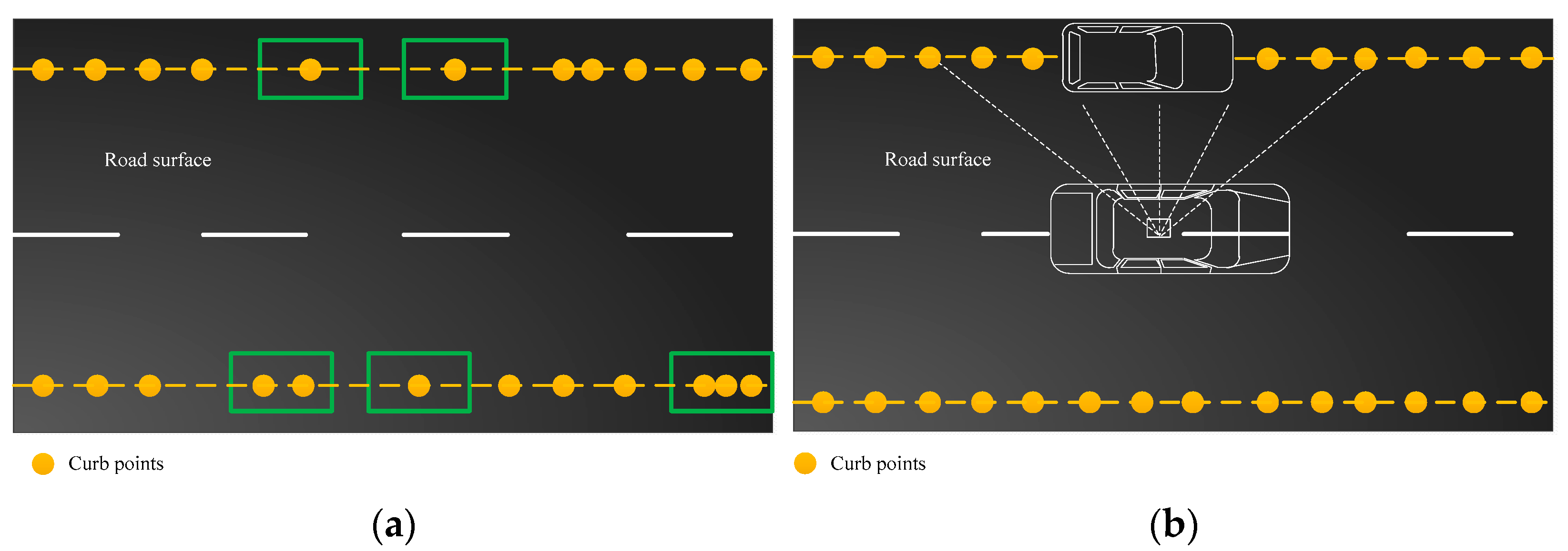
Table 2 shows the comparison between the length of the real road curb and the length of the road curb extracted by the method proposed in this paper, from which it can be seen that the proposed method can effectively extract the curb points under the premise of ensuring calculation efficiency. Figure 14 shows the results of road curb extraction using the proposed method for the four point cloud data in Figure 9, from which it can be seen that most of the road curb in the straight road sections, curves, and intersections can be well extracted, and the overall outline of the road is clear, but in terms of road boundary continuity, there are local fractures in the extraction results. As shown in Figure 14a, the road boundary in Data 1 can almost be extracted, but there are local breaks. This is mainly due to the fact that the extracted curb points were sparsely distributed due to the extremely low curb structures in some areas, as manifested by the sparse points in the green frame of Figure 15a, and such points were falsely regarded as noise points and eliminated during DBSCAN clustering and denoising, which also resulted in the fractured results of road curb extraction. And for the results in Figure 14b–d, in which the extracted road boundaries have breaks mainly due to the fact that some curb point clouds were blocked by vehicles parking at the roadside, as shown in Figure 15b. The upper parts of the acquired vehicle point clouds were eliminated by the CSF method, but the data of the bottom of the vehicle were reserved. Most points were therefore eliminated because they failed to meet the geometric feature constraints during candidate curb point extraction, and the remaining noise points were removed during DBSCAN clustering, leading to fractured extraction and reduced continuity of the curb points extracted at vehicle occlusion.
4.4. Quantitative Results
The curb points extracted by the proposed algorithm were inputted into CloudCompare software for measurement and statistics. The length of the correctly extracted road curb was recorded as TP, that is, the extracted road curb was consistent with the actual road curb. The length of the incorrectly extracted road curb was recorded as FP, that is, the extracted road curb did not match the actual road curb. The length of the missed extracted road curb was recorded as FN, that is, the part that actually existed but was not extracted. The result was evaluated using three indexes widely applied in the existing literature, precision, recall, and quality, which were calculated as in Equation (6). Therein, the values of TP, FP, and FN were the sum of the lengths of the coverage range of the road curb points on both sides of the road.
The statistical results of the accuracy evaluation are listed in Table 3. Combining Table 2 and Figure 13 shows that the proposed method was simple and practical with a high curb extraction accuracy, displaying superior performance in the urban road data used in this experiment. Precision always exceeded 90%, and quality exceeded 75%.
4.5. Comparative Analysis of Different Methods
To further verify the performance of this method, the curb point extraction results of the proposed method were compared with those of the methods proposed in References [43,44,45]. Data 2 shown in Figure 9 was selected for comparison experiments. The data contained complex scenes, such as fences, border trees, and vehicle occlusion. The data could regularize scanning lines, providing basic data support for Reference [43]. The method proposed in Reference [43] separates the point cloud into scan lines and extracts the road curb points by detecting corner points, which have a large bending angle. This method exhibits high calculation accuracy and efficiency in a simple road environment, but its performance is not ideal for the data in this paper. Due to the similar geometric features of roadside fences and curbs, the method in Reference [43] failed to effectively separate the two, resulting in a large number of pseudo curb points. The accuracy of curb point extraction was reduced due to the irregular distribution of points and the poor extraction of scanning lines, so the accurate extraction of scanning lines is the key to this method. In Reference [44], the point cloud was divided into data blocks according to the driving trajectory, and the road curb points were extracted according to the slope and height difference in the data blocks. This method overcomes the influence of the poor separation of scanning lines; however, the trajectory data of vehicles are required. Influenced by roadside fences, similarly, the accuracy of this method is relatively low. Given the high point density at the location of the road curb, the density grid image of ground points was established in Reference [45], and the road curb points were extracted by the Canny edge detection operator. This method has a wide range of applications and is applicable to data that lack driving trajectories; however, its shortcomings are also obvious. First, the density of points in the grid is also large after the plane projection of the roadside fence point. Moreover, in the process of Canny edge detection, some fences and curbs are linearly distributed, making it difficult to distinguish them effectively, resulting in the presence of curbs and fences in the detection results. Second, point cloud rasterization will cause the loss of some point clouds, which will distort the image. These reasons comprehensively affect the extraction accuracy of the road curb. To sum up, the accuracy of the method for comparisons is slightly lower, which is mainly attributed the poor extraction of scanning lines caused by the irregular distribution of point clouds and the large number of pseudo road boundary points induced by the existence of continuous roadside fences. In comparison with the methods in References [43,44,45], the method proposed in this paper belongs to a point cloud voxelization method, which avoids a situation where scanning lines fail to be separated due to the irregular distribution of point clouds. By using cuboid voxels that conform to the characteristics of road curb points as the research basis while removing fences and other ground objects through intensity thresholds, the accuracy of road curb extraction by the proposed method was improved. Table 4 shows the comparison of different methods in precision. The precision and quality coefficients of the proposed method were improved, but the recall coefficient of the results was not significantly improved due to occlusion or for other reasons. Notably, if the method in this study is applied to other point cloud data, then attention should be paid to the setting of the voxel size and intensity threshold. The point spacing and ground object material will vary with the different equipment and road environments, and the appropriate threshold values need to be selected through experiments. For details, please refer to the specific principles of threshold setting in Section 4.2.
5. Conclusions
Efficient road boundary or road curb extraction technology based on point cloud can promote the construction of intelligent transportation and the development of the high-precision map industry. Mixed voxels can be easily produced if road curb points are voxelized using conventional cubic voxels, which will result in geometric features, such as the normal vector of road curb voxels not being obvious. Hence, a road boundary extraction method based on cuboid voxels was proposed in this paper. This method has exhibited the following advantages: (1) In comparison with the classical cubic voxels, using cuboid voxels that are applicable to the geometric features of the curb can effectively avoid the production of mixed voxels at the curb and highlight the two geometric features of curb voxels (i.e., normal vector and distribution dimension), which is convenient for accurate curb voxel extraction. (2) With road curb points as road boundary points, road boundary points were indirectly extracted by extracting road curb points in this study, providing necessary basic data for extracting road boundaries. (3) To effectively distinguish road curbs from the bottom points of fences and street trees, the candidate curb voxels meeting geometric features were further screened using the intensity threshold, thereby effectively solving the difficulty in distinguishing road curbs from the ground objects sharing the similar geometric features to road curbs.
A test was performed using the MLS data acquired by the SSW vehicle-mounted MMS and IQmulus & TerraMobilita competition dataset. The experimental results revealed that the proposed method could accurately extract road curb points. For the two groups of experimental data in this study, the precision coefficient exceeded 90%, and the quality coefficient reached over 75%. For now, the integrity of the results was not high, which was mainly attributed to vehicle occlusion. What the proposed method achieved was a staged result, based on which road boundaries would be further extracted. The integrity of the result and the extraction precision could be further improved through boundary vectorization, and the noise in the existing result could be further eliminated.
Author Contributions
Writing—review and editing, Jingxue Wang; Methodology, Writing—original draft, Xiao Dong; Funding acquisition, Jingxue Wang and Guangwei Liu. All authors have read and agreed to the published version of the manuscript.
Funding
This research was funded by National Natural Science Foundation of China (no. 41871379), Liaoning Revitalization Talents Program (no. XLYC2007026), and Liaoning Province Applied Basic Research Program (no. 2022JH2/101300273).
Data Availability Statement
The data presented in this study are available on request from the corresponding author.
Conflicts of Interest
The authors declare no conflict of interest.
References
- Shirowzhan, S.; Tan, W.; Sepasgozar, S.M.E. Digital Twin and CyberGIS for Improving Connectivity and Measuring the Impact of Infrastructure Construction Planning in Smart Cities. ISPRS Int. J. Geo Inf. 2020, 9, 240. [Google Scholar] [CrossRef]
- Xiao, W.; Cao, H.; Tang, M.; Zhang, Z.; Chen, N.C. 3D Urban Object Change Detection from Aerial and Terrestrial Point Clouds: A Review. Int. J. Appl. Earth Obs. Geoinf. 2023, 118, 103258. [Google Scholar] [CrossRef]
- Yang, B.; Liu, Y.; Dong, Z.; Liang, F.; Li, B.; Peng, X. 3D Local Feature BKD to Extract Road Information from Mobile Laser Scanning Point Clouds. ISPRS J. Photogramm. Remote Sens. 2017, 130, 329–343. [Google Scholar] [CrossRef]
- Yang, T.; Zhang, L.; Wang, H.; Zhang, Y. Road Vector Map Change Monitoring Based on High Resolution Remote Sensing Images. Remote Sens. 2014, 3, 272–279. [Google Scholar] [CrossRef]
- Bastani, F.; He, S.; Abbar, S.; Alizadeh, M.; Balakrishnan, H.; Chawla, S.; Madden, S.; DeWitt, D. RoadTracer: Automatic Extraction of Road Networks from Aerial Images. In Proceedings of the IEEE Conference on Computer Vision and Pattern Recognition, Salt Lake City, UT, USA, 18–23 June 2018. [Google Scholar]
- Xu, Z.; Liu, Y.; Sun, Y.; Liu, M.; Wang, L. RNGDet++: Road Network Graph Detection by Transformer with Instance Segmentation and Multi-Scale Features Enhancement. IEEE Robot. Auto. Let. 2020, 8, 2991–2998. [Google Scholar] [CrossRef]
- Yu, Y.; Li, J.; Guan, H.; Jia, F.; Wang, C. Learning Hierarchical Features for Automated Extraction of Road Markings From 3-D Mobile LiDAR Point Clouds. IEEE J. Sel. Top. Appl. Earth Obs. Remote Sens. 2015, 8, 709–726. [Google Scholar] [CrossRef]
- Ma, L.; Li, Y.; Li, J.; Wang, C.; Wang, R.; Chapman, M. Mobile Laser Scanned Point-Clouds for Road Object Detection and Extraction: A Review. Remote Sens. 2018, 10, 1531. [Google Scholar] [CrossRef]
- Wang, C.; Wen, C.; Dai, Y.; Yu, S.; Liu, M. Urban 3D Modeling with Mobile Laser Scanning: A Review. Virtual Real. Intell. Hardw. 2020, 2, 175–212. [Google Scholar] [CrossRef]
- Sisco, E.; Moorthy, A.S.; Watt, L.M. Creation and Release of an Updated NIST DART-MS Forensics Database. J. Am. Soc. Mass Spectrom. 2021, 32, 685–689. [Google Scholar] [CrossRef] [PubMed]
- Wang, Z.; Yang, L.; Sheng, Y.; Shen, M. Pole-Like Objects Segmentation and Multiscale Classification-Based Fusion from Mobile Point Clouds in Road Scenes. Remote Sens. 2021, 13, 4382. [Google Scholar] [CrossRef]
- Wang, R.; Peethambaran, J.; Chen, D. LiDAR Point Clouds to 3-D Urban Models: A Review. IEEE J. Sel. Top. Appl. Earth Obs. Remote Sens. 2018, 11, 606–627. [Google Scholar] [CrossRef]
- Guan, H.; Li, J.; Cao, S.; Yu, Y. Use of Mobile LiDAR in Road Information Inventory: A Review. Int. J. Image Data Fusion 2016, 7, 219–242. [Google Scholar] [CrossRef]
- Huang, R.; Chen, J.; Liu, J.; Liu, L.; Yu, B.; Wu, Y. A Practical Point Cloud Based Road Curb Detection Method for Autonomous Vehicle. Information 2017, 8, 93. [Google Scholar] [CrossRef]
- Hata, A.Y.; Wolf, D.F. Feature Detection for Vehicle Localization in Urban Environments Using a Multilayer LIDAR. IEEE Trans. Intell. Transp. Syst. 2016, 17, 420–429. [Google Scholar] [CrossRef]
- Yang, B.; Fang, L.; Li, J. Semi-Automated Extraction and Delineation of 3D Roads of Street Scene from Mobile Laser Scanning Point Clouds. ISPRS J. Photogramm. Remote Sens. 2013, 79, 80–93. [Google Scholar] [CrossRef]
- Huang, J.; Choudhury, P.K.; Yin, S.; Zhu, L. Real-Time Road Curb and Lane Detection for Autonomous Driving Using LiDAR Point Clouds. IEEE Access. 2021, 9, 144940–144951. [Google Scholar] [CrossRef]
- Guan, H.; Li, J.; Yu, Y.; Chapman, M.; Wang, C. Automated Road Information Extraction from Mobile Laser Scanning Data. IEEE Trans. Intell. Transp. Syst. 2015, 16, 194–205. [Google Scholar] [CrossRef]
- Viola, P.; Jones, M. Rapid Object Detection Using a Boosted Cascade of Simple Features. In Proceedings of the 2001 IEEE Computer Society Conference on Computer Vision and Pattern Recognition, Kauai, HI, USA, 8–14 December 2001. [Google Scholar]
- Von, G.R.G.; Jakubowicz, J.; Morel, J.M.; Randall, G. LSD: A Fast Line Segment Detector with a False Detection Control. IEEE Trans. Pattern Anal. Mach. Intell. 2010, 32, 722–732. [Google Scholar]
- Kumar, P.; Lewis, P.; McCarthy, T. The Potential of Active Contour Models in Extracting Roads from Mobile Laser Scanning Data. Infrastructures 2017, 2, 9. [Google Scholar] [CrossRef]
- Rodríguez, C.B.; García, C.S.; Ordóñez, C.; Alonso, M.C. An Approach to Detect and Delineate Street Curbs from MLS 3D Point Cloud Data. Autom. Constr. 2015, 51, 103–112. [Google Scholar] [CrossRef]
- Varney, N.M.; Asari, V.K. Volumetric Features for Object Region Classification in 3D LiDAR Point Clouds. In Proceedings of the 2014 IEEE Applied Imagery Pattern Recognition Workshop (AIPR), Washington, DC, USA, 14–16 October 2014. [Google Scholar]
- Dong, X.; Ze, L.Y.; Jian, L.; Zheng, M.G.; Yuan, H.F.; Ling, Y.Y. Road Extraction from Point Clouds of Open-Pit Mine Using LPFE-Net. IEEE Geosci. Remote Sens. Lett. 2023, 20, 6501005. [Google Scholar]
- Wen, C.; You, C.; Wu, H.; Wang, C.; Fan, X.; Li, J. Recovery of Urban 3D Road Boundary via Multi-Source Data. ISPRS J. Photogramm. Remote Sens. 2019, 156, 184–201. [Google Scholar] [CrossRef]
- Charles, R.Q.; Su, H.; Kaichun, M.; Guibas, L.J. PointNet: Deep Learning on Point Sets for 3D Classification and Segmentation. In Proceedings of the 2017 IEEE Conference on Computer Vision and Pattern Recognition (CVPR), Honolulu, HI, USA, 21–26 July 2017. [Google Scholar]
- Balado, J.; Martínez, S.J.; Arias, P. Novo Road Environment Semantic Segmentation with Deep Learning from MLS Point Cloud Data. Sensors 2019, 19, 3466. [Google Scholar] [CrossRef]
- Rachmadi, F.R.; Uchimura, K.; Koutaki, G.; Ogata, K. Road Edge Detection on 3D Point Cloud Data Using Encoder-Decoder Convolutional Network. In Proceedings of the 2017 International Electronics Symposium on Knowledge Creation and Intelligent Computing (IES-KCIC), Surabaya, Indonesia, 26–27 September 2017. [Google Scholar]
- Harith, A.; Debra, F.; Laefer, D.C. Point cloud voxel classification of aerial urban LiDAR using voxel attributes and random forest approach. Int. J. Appl. Earth Obs. Geoinf. 2023, 118, 1569–8432. [Google Scholar]
- Xu, S.; Wang, R.; Zheng, H. Road Curb Extraction from Mobile LiDAR Point Clouds. IEEE Trans. Geosci. Remote Sens. 2017, 55, 996–1009. [Google Scholar] [CrossRef]
- Tran, T.H.; Chaisomphob, T. Automated Extraction of Expressway Road Surface from Mobile Laser Scanning Data. J. Cent. S. Univ. 2020, 27, 1917–1938. [Google Scholar] [CrossRef]
- Papon, J.; Abramov, A.; Schoeler, M.; Worgotter, F. Voxel Cloud Connectivity Segmentation—Supervoxels for Point Clouds. In Proceedings of the 2013 IEEE Conference on Computer Vision and Pattern Recognition, Portland, OR, USA, 23–28 June 2013. [Google Scholar]
- Zai, D.; Li, J.; Guo, Y.; Cheng, M.; Lin, Y.; Luo, H.; Wang, C. 3-D Road Boundary Extraction from Mobile Laser Scanning Data via Supervoxels and Graph Cuts. IEEE Trans. Intell. Transp. Syst. 2018, 19, 802–813. [Google Scholar] [CrossRef]
- Mi, X.; Yang, B.; Dong, Z.; Chen, C.; Gu, J. Automated 3D Road Boundary Extraction and Vectorization Using MLS Point Clouds. IEEE Trans. Intell. Transp. Syst. 2022, 23, 5287–5297. [Google Scholar] [CrossRef]
- Xu, Y.; Tong, X.; Stilla, U. Voxel-Based Representation of 3D Point Clouds: Methods, Applications, and Its Potential Use in the Construction Industry. Autom. Constr. 2021, 126, 103675. [Google Scholar] [CrossRef]
- Zhang, W.; Qi, J.; Wan, P.; Wang, H.; Xie, D.; Wang, X.; Yan, G. An Easy-to-Use Airborne LiDAR Data Filtering Method Based on Cloth Simulation. Remote Sens. 2016, 8, 501. [Google Scholar] [CrossRef]
- Cordone, L.; Miramond, B.; Thierion, P. Object Detection with Spiking Neural Networks on Automotive Event Data. In Proceedings of the 2022 International Joint Conference on Neural Networks, Padua, Italy, 18–23 July 2022. [Google Scholar]
- Vo, A.V.; Truong, H.L.; Laefer, D.F.; Bertolotto, M. Octree-Based Region Growing for Point Cloud Segmentation. ISPRS J. Photogramm. Remote Sens. 2015, 104, 88–100. [Google Scholar] [CrossRef]
- Unnikrishnan, R.; Lalonde, J.; Vandapel, N.; Hebert, M. Scale selection for geometric fitting in noisy point clouds. Int J. Comput. Geom. Appl. 2010, 20, 543–575. [Google Scholar] [CrossRef]
- Yang, B.; Dong, Z.; Liu, Y.; Liang, F.; Wang, Y. Computing Multiple Aggregation Levels and Contextual Features for Road Facilities Recognition Using Mobile Laser Scanning Data. ISPRS J. Photogramm. Remote Sens. 2017, 126, 180–194. [Google Scholar] [CrossRef]
- Ester, M.; Kriegel, H.P.; Sander, J.; Xu, X. A Density-Based Algorithm for Discovering Clusters in Large Spatial Databases with Noise; AAAI Press: Washington, DC, USA, 1996; Volume 06, pp. 226–231. [Google Scholar]
- Gao, J.; Chen, Y.; Junior, J.M.; Wang, C.; Li, J. Rapid Extraction of Urban Road Guardrails from Mobile LiDAR Point Clouds. IEEE Trans. Intell. Transp. Syst. 2022, 23, 1572–1577. [Google Scholar] [CrossRef]
- Honma, R.; Date, H.; Kanai, S. MLS Point Cloud Segmentation Based on Feature Points of scanlines. Int. Arch. Photogramm. Remote Sens. Spat. Inf. Sci. 2019, 42, 1007–1013. [Google Scholar] [CrossRef]
- Ye, C.; Zhao, H.; Ma, L.; Jiang, H.; Li, H.; Wang, R.; Chapman, M.A.; Junior, J.M.; Li, J. Robust Lane Extraction from MLS Point Clouds Towards HD Maps Especially in Curve Road. IEEE Trans. Intell. Transp. Syst. 2022, 23, 1505–1518. [Google Scholar] [CrossRef]
- El-Halawany, S.; Moussa, A.; Lichti, D.D.; El-Sheimy, N. Detection of Road Curb from Mobile Terrestrial Laser Scanner Point Cloud. Int. Arch. Photogramm. Remote Sens. Spat. Inf. Sci. 2012, 38, 109–114. [Google Scholar] [CrossRef]
Figure 1.
Flowchart of the extraction algorithm road curb points.

Figure 2.
Schematic of cuboid voxels.

Figure 3.
Voxelization using different types of voxel at the road curb: (a) original point cloud; (b) cubic voxelization; (c) cuboid voxelization.
Figure 3.
Voxelization using different types of voxel at the road curb: (a) original point cloud; (b) cubic voxelization; (c) cuboid voxelization.
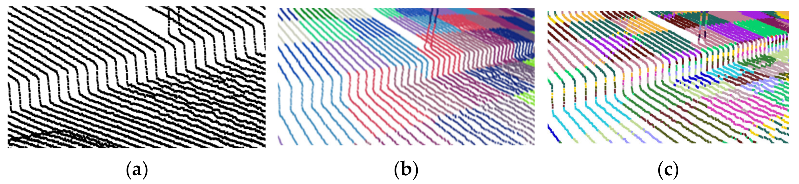
Figure 4.
Schematic of point distribution in the voxels of different surface features: (a) Schematic of the roadway voxel; (b) Schematic of the road curb voxel. Notes: The red dotted squares represent the planes obtained by plane fitting with the internal points in each voxel.
Figure 4.
Schematic of point distribution in the voxels of different surface features: (a) Schematic of the roadway voxel; (b) Schematic of the road curb voxel. Notes: The red dotted squares represent the planes obtained by plane fitting with the internal points in each voxel.
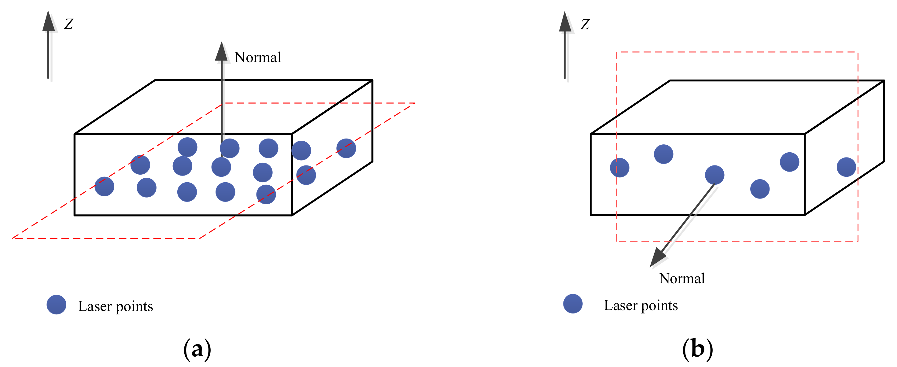
Figure 5.
Voxelization results of different ground object point using cuboid voxels in this study: (a) Roadway point cloud voxelization; (b) Road curb point cloud voxelization. Notes: The red box represents that the location is in a road curb voxel, and the points within it are road curb points.
Figure 5.
Voxelization results of different ground object point using cuboid voxels in this study: (a) Roadway point cloud voxelization; (b) Road curb point cloud voxelization. Notes: The red box represents that the location is in a road curb voxel, and the points within it are road curb points.
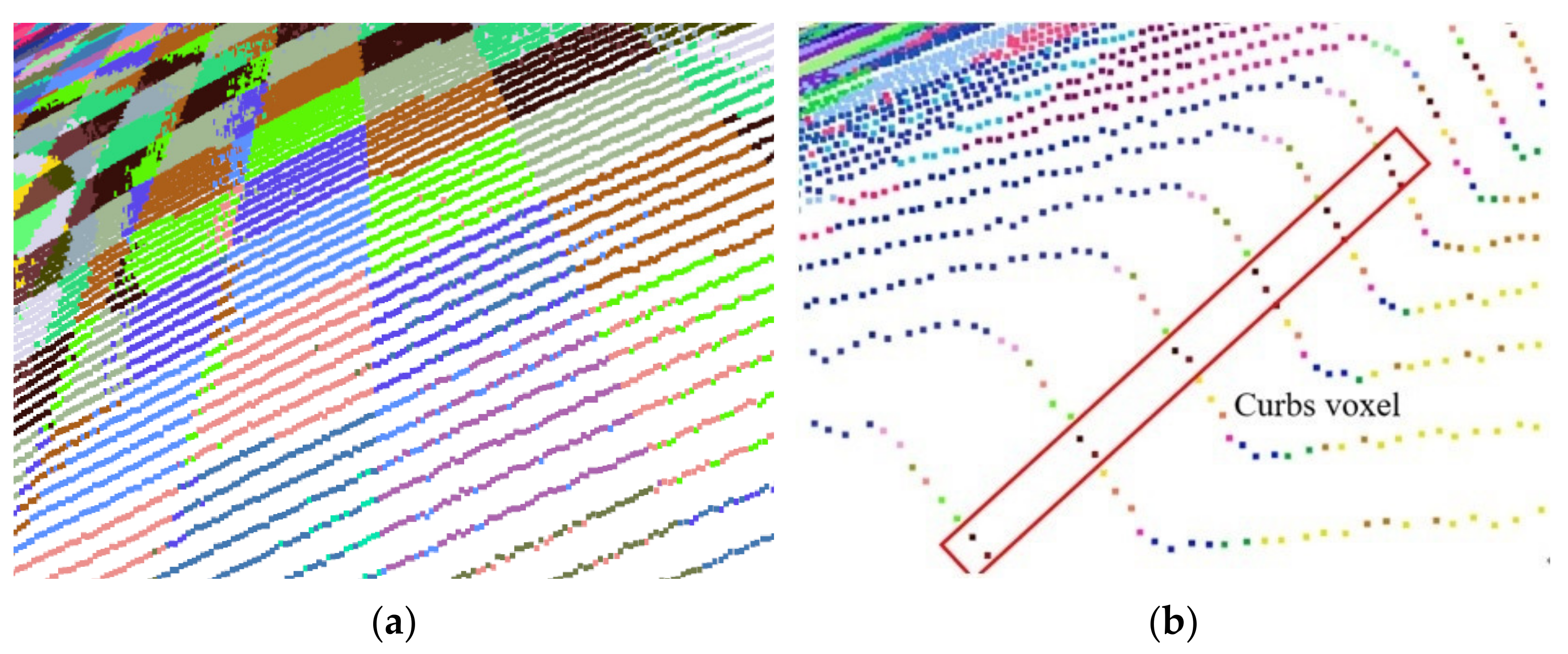
Figure 6.
Ground points obtained by CSF method. Notes: The black rectangular area represents the bottom of street trees amd the blue rectangular area is the bottom of fences.
Figure 6.
Ground points obtained by CSF method. Notes: The black rectangular area represents the bottom of street trees amd the blue rectangular area is the bottom of fences.

Figure 7.
Intensity values in color of different ground objects.

Figure 8.
Road curb points before and after denoising: (a) Before denoising; (b) After denoising.
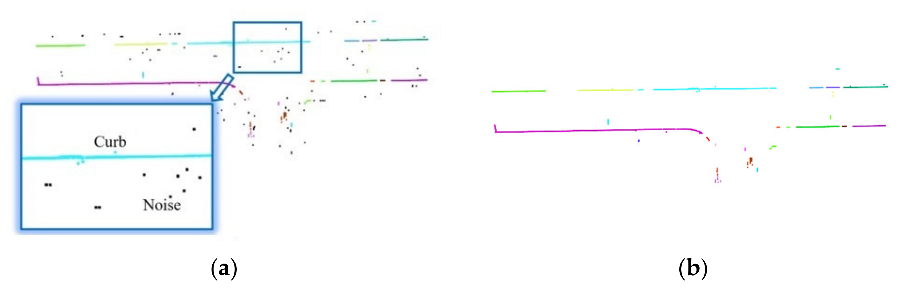
Figure 9.
Experimental data: (a) Data 1; (b) Data 2; (c) Data 3; (d) Data 4.

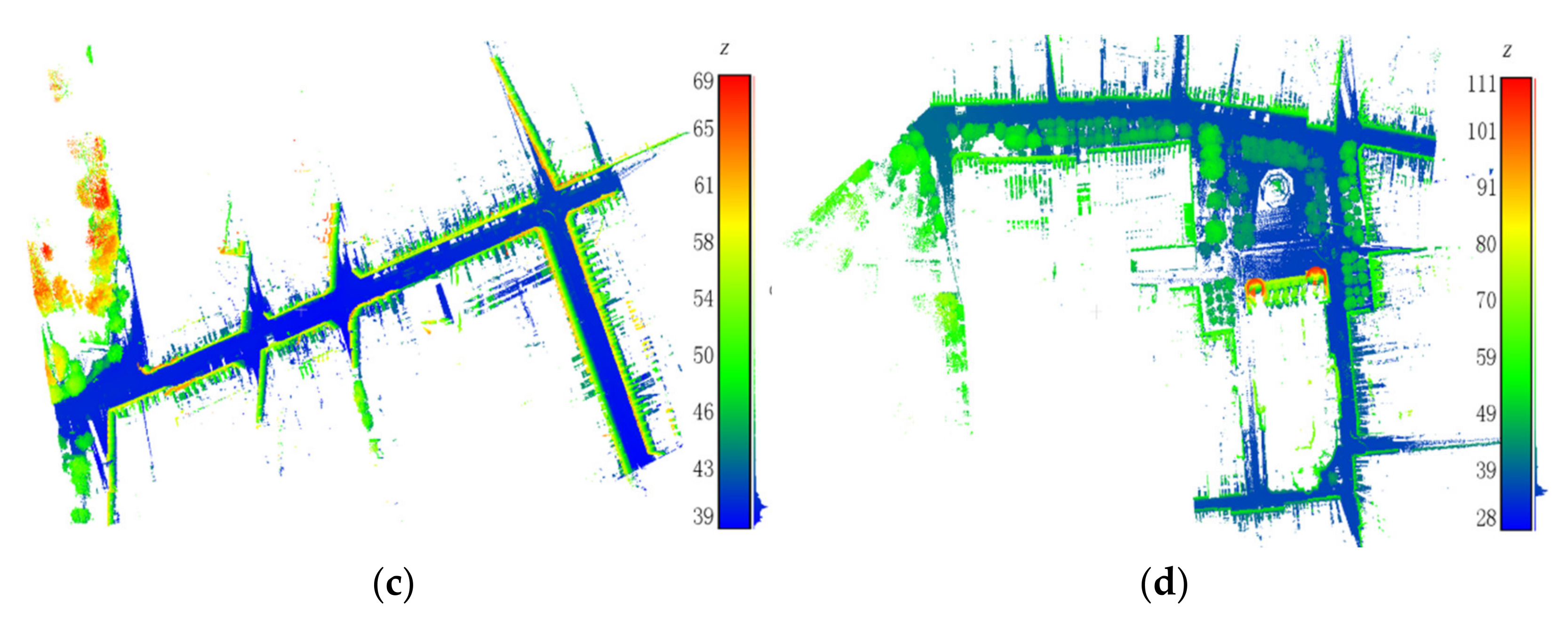
Figure 10.
Schematic of point distribution on the scanning line.
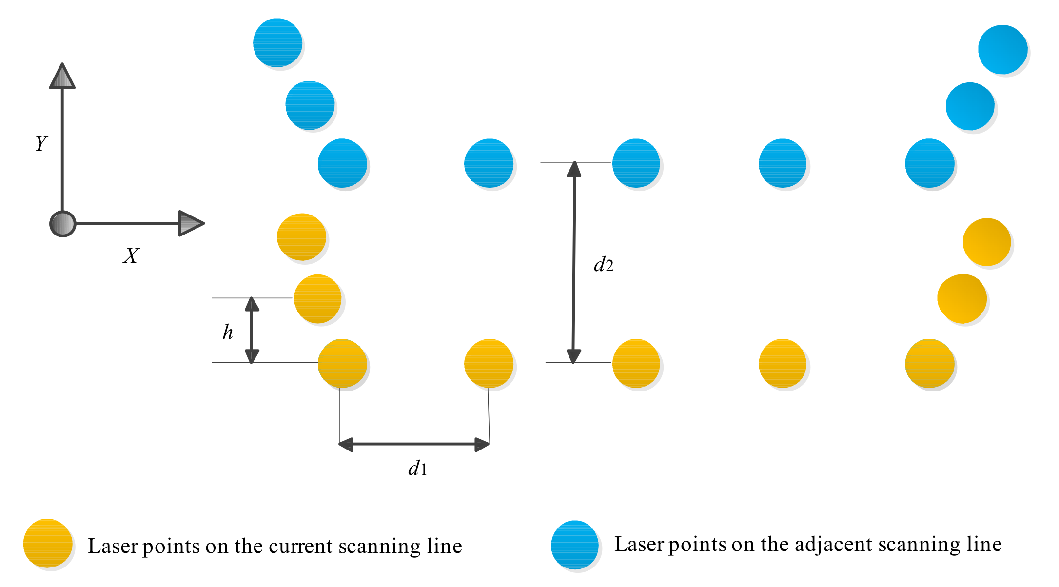
Figure 11.
Accuracy of curb point extraction based on different voxel sizes.
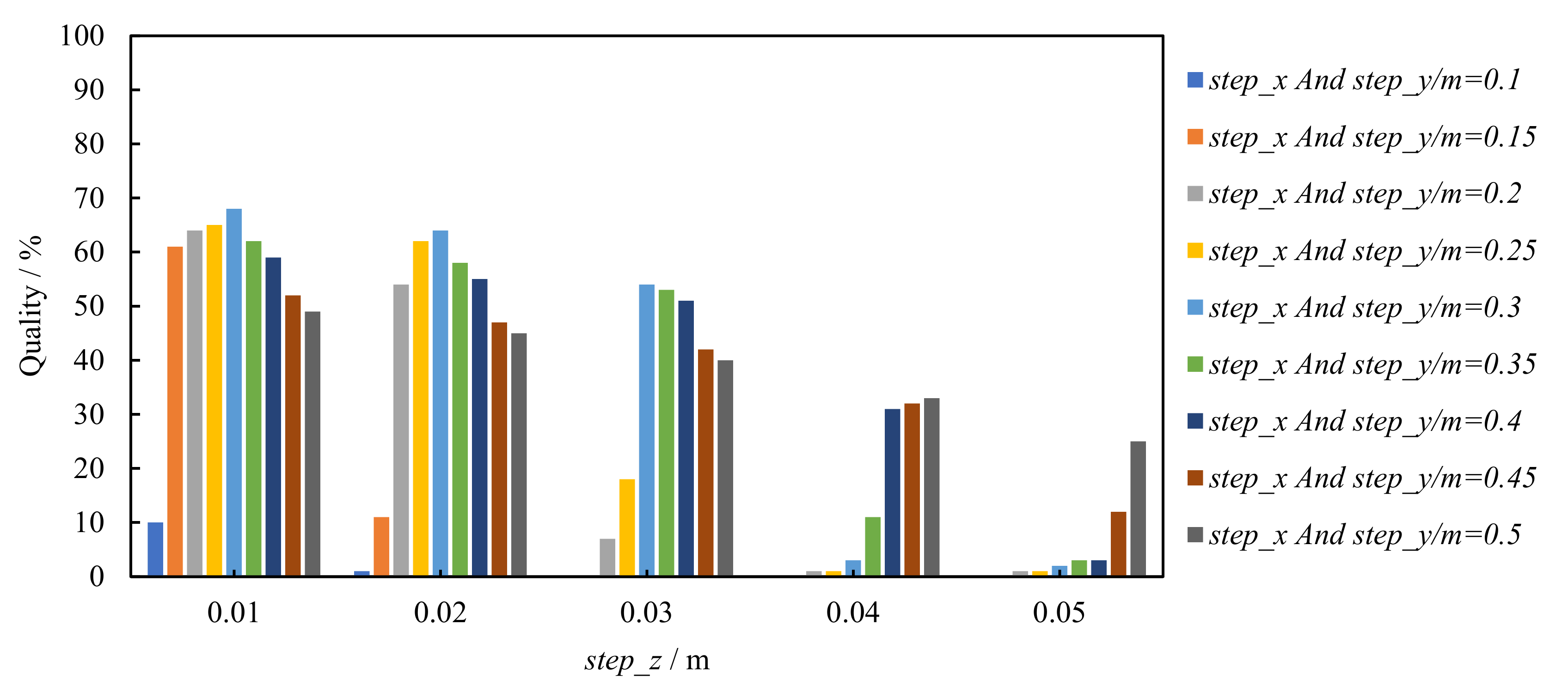
Figure 12.
Running time of the algorithm under different values of step_z.
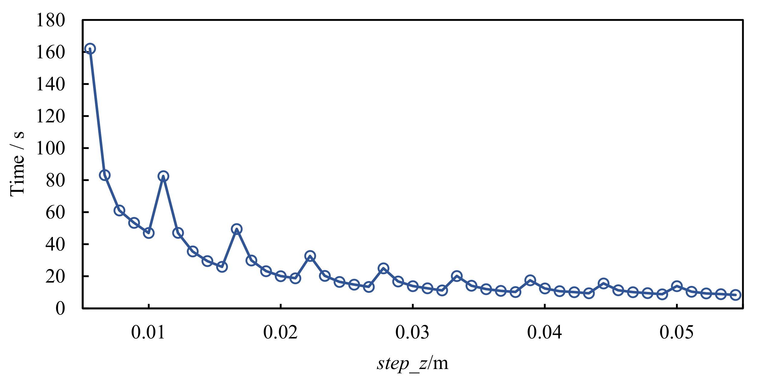
Figure 13.
Accuracy of curb point extraction based on different values of Th_a.
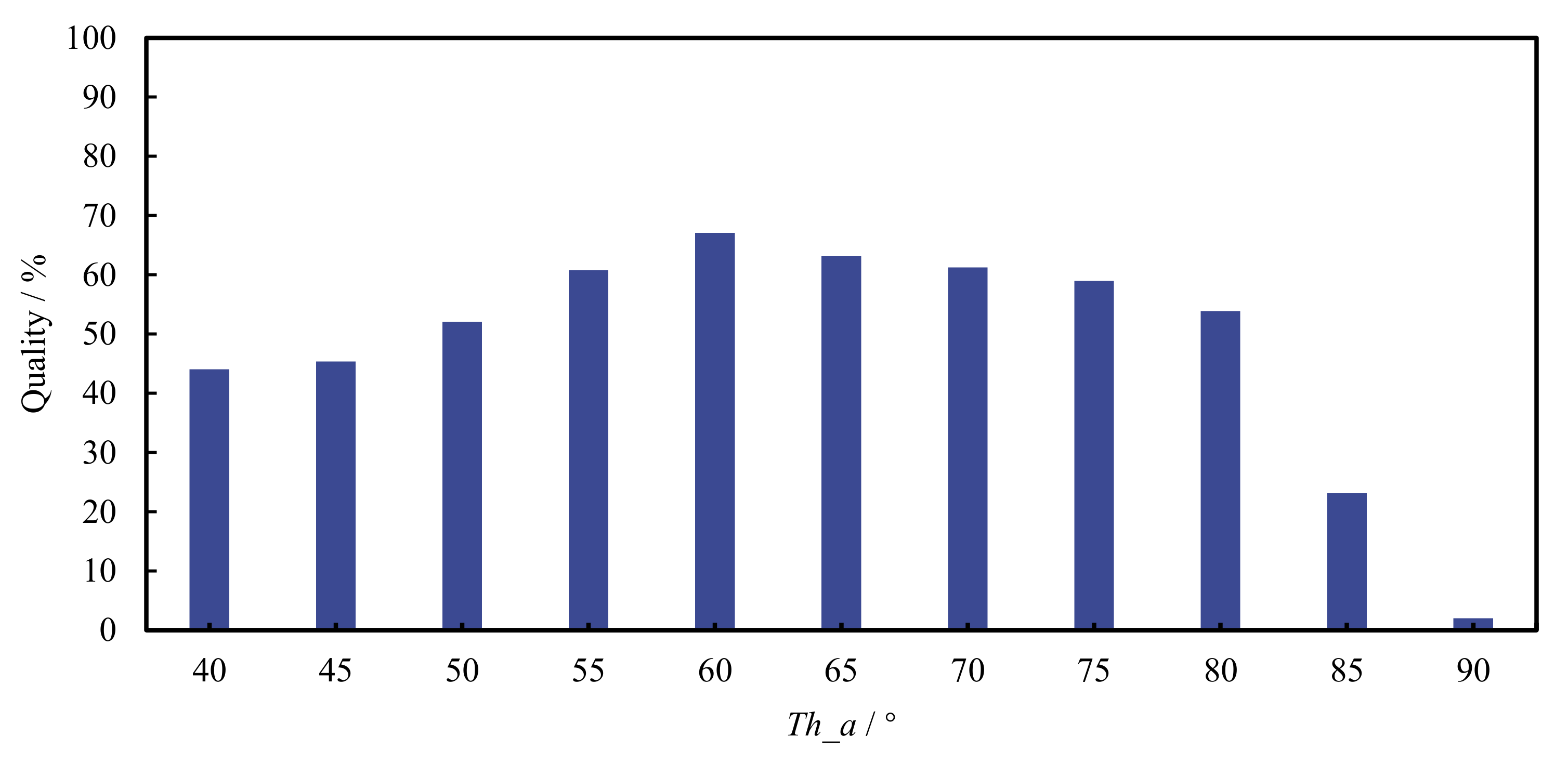
Figure 14.
Extraction results of road curb points by the proposed method: (a) Road curb points extracted in Data 1; (b) Road curb points extracted in Data 2; (c) Road curb points extracted in Data 3; (d) Road curb points extracted in Data 4.
Figure 14.
Extraction results of road curb points by the proposed method: (a) Road curb points extracted in Data 1; (b) Road curb points extracted in Data 2; (c) Road curb points extracted in Data 3; (d) Road curb points extracted in Data 4.
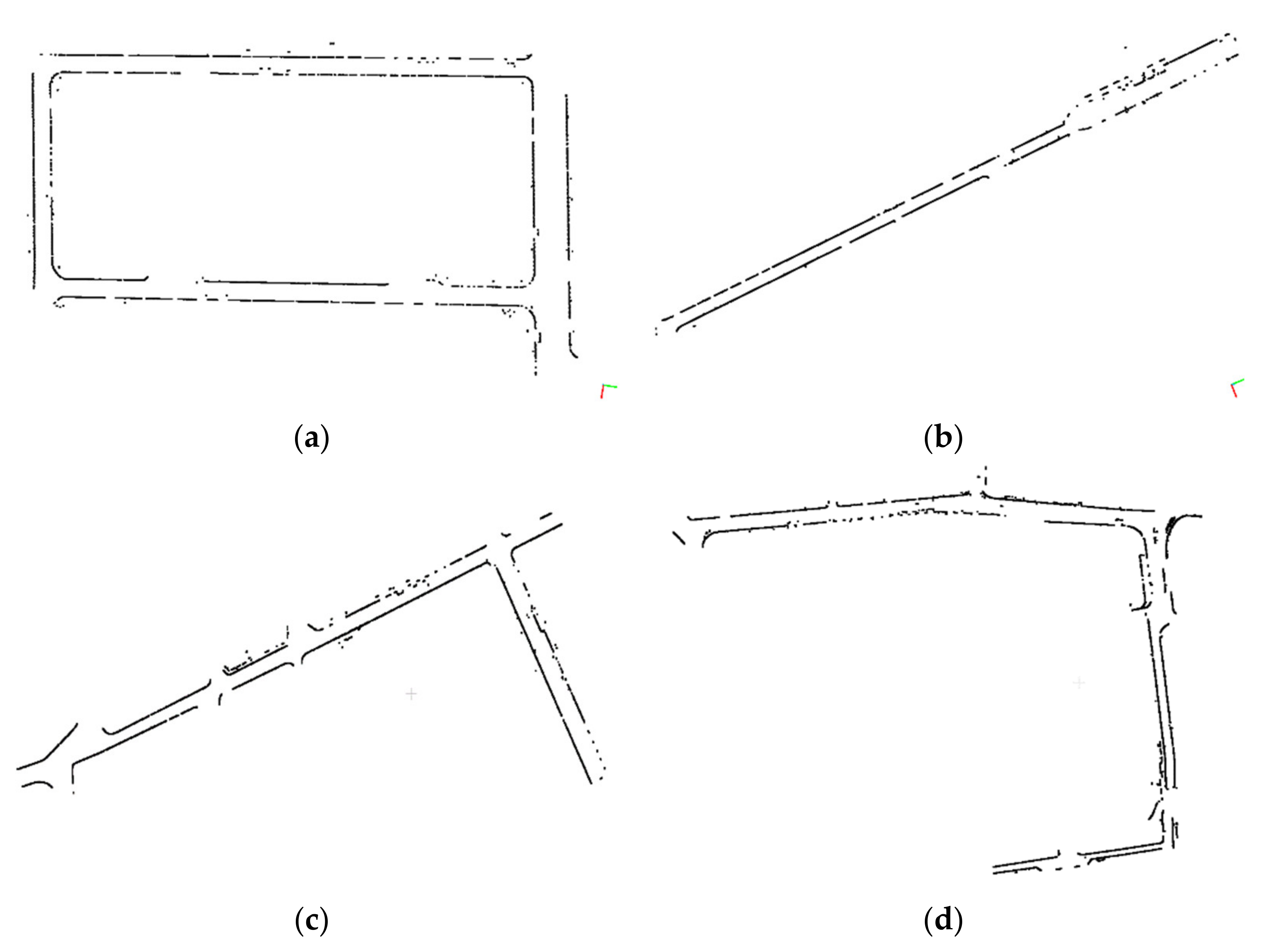
Figure 15.
Schematic of fractures in the curb point extraction result: (a) Sparsely distributed curb points; (b) Vehicle occlusion.
Figure 15.
Schematic of fractures in the curb point extraction result: (a) Sparsely distributed curb points; (b) Vehicle occlusion.

Table 1.
Parameter setting.
| Parameter | Parameter Value |
|---|---|
| Voxel sizes step_x, step_y, and step_z/m | 0.3, 0.3, 0.02 |
| Included angle threshold Th_a/° | 60 |
| Linear dimension threshold Th_e | 0.1 |
| Intensity range Th_ i | [−12, −10] |
| Searching radius Th_epx | 0.3 |
| Point number threshold in the cluster Th_Minpts | 6 |
Table 2.
Statistics of the extraction results of road curb points for the proposed algorithm.
| Dataset | Left | Right | Total | |||
|---|---|---|---|---|---|---|
| LS/m | LD/m | RS/m | RD/m | TS/m | TD/m | |
| Data 1 | 674.2 | 534.7 | 580.5 | 469.4 | 1254.7 | 1004.1 |
| Data 2 | 204.9 | 162.5 | 216.8 | 177.3 | 421.7 | 339.8 |
| Data 3 | 433.3 | 304.9 | 391.9 | 370.3 | 825.2 | 675.2 |
| Data 4 | 661.6 | 524.7 | 581.2 | 478.9 | 1242.8 | 1003.6 |
Table 3.
Accuracy evaluation of curb point extraction results obtained by the proposed algorithm.
| Dataset | TP/m | FP/m | FN/m | Precision/% | Recall/% | Quality/% |
|---|---|---|---|---|---|---|
| Data 1 | 1004.1 | 27.8 | 250.6 | 97.3 | 80.0 | 78.3 |
| Data 2 | 339.8 | 24.3 | 81.9 | 93.3 | 80.6 | 76.2 |
| Data 3 | 675.2 | 34.4 | 150.0 | 95.2 | 81.8 | 78.5 |
| Data 4 | 1003.6 | 94.6 | 239.2 | 91.4 | 80.8 | 75.0 |
Table 4.
Comparative analysis of the results of different algorithms for road curb extraction based on data in Figure 9b.
Disclaimer/Publisher’s Note: The statements, opinions and data contained in all publications are solely those of the individual author(s) and contributor(s) and not of MDPI and/or the editor(s). MDPI and/or the editor(s) disclaim responsibility for any injury to people or property resulting from any ideas, methods, instructions or products referred to in the content. |
© 2023 by the authors. Licensee MDPI, Basel, Switzerland. This article is an open access article distributed under the terms and conditions of the Creative Commons Attribution (CC BY) license (https://creativecommons.org/licenses/by/4.0/).
Share and Cite
MDPI and ACS Style
Wang, J.; Dong, X.; Liu, G. Extraction of Urban Road Boundary Points from Mobile Laser Scanning Data Based on Cuboid Voxel. ISPRS Int. J. Geo-Inf. 2023, 12, 426. https://doi.org/10.3390/ijgi12100426
AMA Style
Wang J, Dong X, Liu G. Extraction of Urban Road Boundary Points from Mobile Laser Scanning Data Based on Cuboid Voxel. ISPRS International Journal of Geo-Information. 2023; 12(10):426. https://doi.org/10.3390/ijgi12100426
Chicago/Turabian StyleWang, Jingxue, Xiao Dong, and Guangwei Liu. 2023. "Extraction of Urban Road Boundary Points from Mobile Laser Scanning Data Based on Cuboid Voxel" ISPRS International Journal of Geo-Information 12, no. 10: 426. https://doi.org/10.3390/ijgi12100426
Note that from the first issue of 2016, this journal uses article numbers instead of page numbers. See further details here.