Article

Assessing the Development Level of Logistics for Sustainable Cities in Urban Agglomeration Based on a Multi-Layer Complex Network

1
School of Economics and Management, Chang’an University, Xi’an 710064, China
2
School of Civil and Environmental Engineering, Nanyang Technological University, Singapore 639798, Singapore
3
Department of International Logistics, Chung-Ang University, Seoul 06974, Korea
*
Author to whom correspondence should be addressed.
Systems 2022, 10(5), 171; https://doi.org/10.3390/systems10050171
Submission received: 19 August 2022 / Revised: 14 September 2022 / Accepted: 21 September 2022 / Published: 28 September 2022
(This article belongs to the Section Systems Practice in Social Science)

Abstract

:
Evaluating the development level of urban logistics can significantly inform policies for the sustainable development of each city in an urban agglomeration. This study analyzed the logistics development of 11 cities in the Guanzhong Plain urban agglomeration (GPUA) of China. Compared to traditional urban logistics evaluation methods considering individual attributes, this study constructed a multi-layer complex logistics network of urban agglomerations (MCLNUA) based on complex network theory, which takes into account the multiple connections between cities. The development levels of logistics in these cities were evaluated from a multi-dimensional perspective of “point–line–surface”, (the “point” represents the node characteristic index of the city, the “line” represents the strength and direction of urban logistics connections between cities, and the “surface” represents the cohesive subgroup of cities). An urban spatial hierarchy and corresponding spatial development plan for urban logistics were also developed. The results show that there are significant differences in logistics levels between different cities. The spatial structure of the overall network connections shows the pattern of being strong in the south and weak in the north, and strong in the east and weak in the west. There are differences in the strength of connections between cohesive subgroups. The research provides a reference for the sustainable development of regional logistics in other urban agglomerations.

1. Introduction

With the rapid development of global economic integration and technology, the logistics industry is playing an increasingly important role in economic development. This is particularly true for achieving efficient development of integrated and sustainable urban agglomeration. The acceleration of regional integration, and the concept of the sustainable development of cities, have encouraged research on urban agglomerations, which are the highest form of spatial organization in the mature stage of urban development. The importance of developing urban agglomerations was particularly emphasized in the outline of 13th Five-Year Plan proposed by the Chinese government. Therefore, this study uses the Guanzhong Plain urban agglomeration (GPUA) of China as the research object, analyzes the development level of urban logistics and constructs the multi-layer complex logistics network of the GPUA, and finally realizes the evaluation of the development level of urban logistics, which is intended to provide a theoretical basis for the future logistics development planning of this urban agglomeration.
The strength of the logistics connection between cities affects the overall function of each city and the region [1]. The urban logistics network is an inseparable organic system, formed by the cooperation of cities with different hierarchies and scales within the region. The interconnection between cities forms the foundation of the network [2]. Each city is embedded in the logistics network, rather than acting independently. Cities are both constrained by the network and can benefit from the network. The embeddedness, such as connections, network positions, and network structure of each node determine the role of each city [3].
The logistics connections between cities can be divided into infrastructure connections, flow connections, and logistics enterprise connections [4]. Infrastructure connections are mainly represented by transportation routes. Flow connections refer to the exchange of freight volume between cities. At present, the typical methods used by scholars on logistics network evaluation include the entropy method, principal component analysis, and cluster analysis. However, these methods have generally used the individual attributes of a city to evaluate the logistics level and have not considered the interconnections between cities. In fact, cities are generally embedded in complex logistics networks. Most previous studies have used the individual attributes of a city to evaluate the logistics level but have not considered the interconnections between cities. A few studies have considered the interconnections involved in only a type of transportation logistic. To address this research gap, this study applied complex network theory and integrated the road freight network, railway freight network, and logistics enterprise network to construct a multi-layer complex logistics network of urban agglomeration (MCLNUA). The model takes into account the connections between cities and logistics networks and enables the comprehensive study of the development level of urban node logistics, from the multiple dimensions of “point–line–surface”.
At the theoretical level, this study uses complex network theory to conduct exploratory research on the evaluation of the logistics development level in urban agglomerations, with the aim to improve the evaluation theory of logistics development level in urban agglomerations to a certain extent. At the practical level, we expect to comprehensively evaluate the development level of logistics in urban agglomerations more scientifically. In addition, depending on the evaluation results, policies are formulated for the sustainable development of each city in an urban agglomeration.
For the “point” dimension, we analyzed the centrality and development potential of cities. For the “line” dimension, we analyzed the strength of the connections in the logistics network and the city’s primary direction. For the “surface” dimension, we analyzed the density of the connections between the embedded cohesive subgroups and other cohesive subgroups. These cohesive subgroups are direct, close, and interconnected collections composed of urban individuals. Next, the study recommends guidelines for logistics development planning for the Guanzhong Plain urban agglomeration (GPUA) based on the city hierarchy, with the goal of improving the overall logistics development efficiency of the GPUA. Assessing the logistics development level of cities in GPUA from multiple dimensions is vital for effective urban management. The evaluation results can provide valuable support for constructing regional logistics development plans to improve the efficiency of urban logistics and encourage sustainable urban development. Moreover, the results could be used to strengthen the cooperation between logistically connected node cities.
The rest of this paper is organized as follows. Section 2 presents the literature review. Section 3 constructs the MCLNUA model for the GPUA and introduces the index for evaluating the level of urban logistics. Section 4 provides the results and discussion. The final section of this study presents the conclusions and recommendations. Figure 1 presents the research framework.

2. Literature Review

2.1. Evaluation of Urban Logistics Level

Existing research evaluating regional logistics capabilities can be divided into two groups: the evaluation index used to evaluate regional logistics capabilities, and the evaluation method used to evaluate those capabilities.
In terms of research on the evaluation indicators of urban logistics, scholars have established a variety of evaluation indicators based on the actual situation. Banomyong et al. [5] analyzed Vietnam’s national logistics system across four key dimensions: infrastructure, service provider, shipper/consignee, and institutional framework. Zou et al. [6] established an evaluation index system of urban logistics competitiveness based on the economic development level, logistics business scale, and information level. Their study also evaluated the logistics competitiveness of 18 sample cities. Bookbinder and Tan [7] reorganized 20 specific criteria into 6 areas to determine logistics development tiers (i.e., infrastructure, performance, information system, human resources, and the business and political environments). Their research also compared the logistics systems of Europe and Asia.
In terms of research on the evaluation method of urban logistics [8,9,10,11,12], Lan [13] used the entropy method to evaluate the logistics and economic development levels of Beijing, Shanghai, Guangzhou, Chongqing, and Tianjin in China. In the same research area, Li et al. [14] analyzed the development of node cities in a road freight network and evaluated the grain distribution capacity of cities involved in the “Belt and Road”. Additionally, Liu et al. [15] evaluated the logistics development level of all provinces in China using a principal component analysis (PCA) and cluster analysis.
Previous studies generally used the city’s own attributes to evaluate the regional logistics development level. However, cities are not independent individuals, instead being embedded in the logistics network [16]. Therefore, these approaches cannot comprehensively evaluate the urban logistics development level. Namely, the logistics development level of a certain city depends on not only its own attributes but also its connections with other cities in the network.

2.2. Urban Logistics Network Analysis

Most previous studies on urban logistics network analysis have investigated the characteristics and spatial pattern of urban logistics networks. The logistics network is generally constructed based on two types of relationships: the freight volume connections between cities, and the connections between logistics enterprises.
In terms of research focusing on the freight volume connections between cities, Matsumoto [17] added cargo flow as an indicator based on international air passenger flow and assessed the development of air passenger and cargo flow networks in three major regions: Asia, Europe, and the Americas. The study also evaluated the logistics capabilities of nine hub cities in these three regions. Tsekeris [18] used the original survey data of road freight traffic in Greece from 2004 to 2012 to analyze the interregional trade network and provided recommendations for planning a Greek national logistics hub network. Other studies have investigated cities and regional networks of different scales from the perspective of aviation [19], railway [20] and highway [21] passengers, and cargo flow [22].
In terms of research about connections between logistics enterprises, Joyez [23] found that the organization network of logistics enterprises is helpful in comparing the degree of inter-city connections and is closely integrated with the construction of the city network. A-level logistics enterprises are high-quality enterprises certified by the Chinese logistics management department in accordance with the “Classification and Evaluation Index of Logistics Enterprises”. Focusing on A-level logistics enterprises in the Yangtze River Delta in China, He et al. [24] investigated the spatial and temporal evolution at the metropolitan and regional levels, respectively, and provided valuable recommendations for the rational planning of logistics spaces. By analyzing the network data of China’s top 100 logistics companies and using the chain network model method, Zong et al. [25] investigated the hierarchical structure, spatial differentiation, spatial connection, and evolutionary characteristics of the urban network in China.
The research discussed above mainly focused on the level of the single-layer network, such as a network based on the inter-city freight volume, the inter-city transportation lines, and the logistics enterprise connections. An analysis based on a complex multi-layer network is more realistic and is more effective for providing practical and operational recommendations.

2.3. Construction of Complex Logistics Network

Complex logistics networks are composed of multiple connections between urban nodes [4]. The construction of multi-layer networks is based on different types of connections. As a result, cities occupy different status and enjoy different connectivity in multi-layer networks. The diverse connections of relationships in each sub-network layer shape the complementarity of the network [26]. Multi-layer complex network theory has been increasingly explored [27], with two key research focuses with respect to complex logistics networks. The first focuses on the structural characteristics of logistics networks. For example, focusing on types of cargo ships in ocean transportation, Gao et al. [28] developed a bi-level programming model for solving container shipping network design problems. Pais Montes et al. [29] studied the characteristics of logistics networks and discussed the rationality of its application to general cargo and containership routes. Ge et al. [30] analyzed the structural characteristics of the “Belt and Road Initiative“ air logistics network from a geospatial perspective. Several scholars have also studied the structural characteristics of the air freight network [31], coastal container network [32], and maritime freight network [26].
Another concern in existing research on complex logistics networks is the robustness analysis of logistics networks. For example, Wang et al. [33] established a reliability simulation model of an emergency logistics network under random attacks and selective attacks. Wang et al. [34] defined the complex logistics network as a logistics infrastructure network and analyzed its robustness. Agustina Calatayud et al. [35] provided evidence that the structure of a multi-layered maritime shipping network experienced different levels of vulnerability for international freight flows. Yang et al. [36] studied the controllability robustness of a complex logistics network using a nonlinear load-capacity model and provided practical recommendations for achieving good connectivity after a cascading failure of a logistics network. The complex network methodology takes the research object into consideration by placing it in its relationship network; consequently, this method has remarkable advantages when studying the research object with group attributes. Nevertheless, most current studies are confined to a certain feature of the network, while few studies can comprehensively consider the network features to implement evaluation.
In summary, the methods used to investigate the development level of regional urban logistics are mostly based on a specific city’s attribute indicators using the entropy method, principal component analysis, and other methods. However, cities are not independent entities in the logistics network, and there are different types of connections between cities. Most studies have focused on a single type of connection. With the continuous application and expansion of multi-layer network theory, studies on the construction of logistics networks based on this multi-layer approach have mainly focused on the internal multi-layer dynamics of a freight network topology. Few studies have investigated the level of urban logistics development from the viewpoint of a multi-layer complex network (Table 1 shows the comparison of the three evaluation methods). This makes it difficult to comprehensively analyze the logistics status and logistics development potential of cities in an urban agglomeration.
Therefore, this study evaluates the development level of urban logistics from the perspective of the logistics connections between cities. The study focused on 11 node cities in the GPUA, combining road freight volume, railway lines, and logistics enterprise connections to study the inter-city relationships. Using complex network theory, we analyzed the development level of urban logistics in the MCLNUA from the three dimensions of “point–line–surface”. The study provides a useful reference for the further development of urban logistics in the GPUA.

3. Model Construction and Data Sources

3.1. Model Construction

3.1.1. The Structure of Multi-Layer Logistics Network in Urban Agglomeration

The logistics connections between cities can be divided into infrastructure connection, flow connection, and logistics enterprise connection [4]. Infrastructure connections are mainly represented by transportation routes and provide necessary conditions for logistics connections to occur between cities. Flow connections refer to the exchange of freight volume between cities and form the core of the inter-city connections. Logistics enterprises are defined as the professional organizations that conduct logistics activities and constitute the functional elements of the inter-city logistics network.
The nodes in the network include 11 cities in the GPUA. The edge of the sub-network layer implies different types of connections. Table 2 shows the meanings of the sub-network layers and nodes. The sub-network layer is represented by Gs(Vs,Es,Ws), where V s = V s i , i = 1 , 2 , 3 , n , representing the collection of city nodes in the urban agglomeration. The expression E s = e s i j , i , j = 1 , 2 , 3 , m represents the set of connection edges between cities in the urban agglomeration; and Ws represents the weight set of each edge in Es. If city i and city j are connected, it is set to Wsij. Matrix Ws is expressed as
W s = 0 w 12 w 1 n 1 w 1 n w 21 0 w 2 n 1 w 2 n w n 1 1 w n 2 2 0 w n 1 n w n 1 w n 2 w n n 1 0
The connection properties of each edge in the sub-network layer differ, and the methods of measuring the weight of the connection edge between cities also differ. To calculate the weights of the connecting edges between cities in the road freight network, Olariaga [37] demonstrated the reliability of applying the gravity model to analyze cargo transportation between cities and regions. As such, this study applies the traditional gravity model to calculate the node urban road freight connection strength.
To calculate the edge weight in a railway freight network, other studies have demonstrated the feasibility of using the number of railway lines to calculate the strength of connections between cities [38]. Therefore, this study uses the number of lines between freight stations in each city to measure the weight of the railway freight network connection (not considering the connection between cities themselves).
To calculate the edge weight in the logistics enterprise network, other studies have demonstrated the significance of applying the interlocking network model [39] to analyze the relationship between urban network nodes. Therefore, this study uses the interlocking network model to investigate the weights of interconnections in the logistics enterprise network. Table 3 provides the specific meanings and calculation methods used.

3.1.2. Construction of MCLNUA

Multi-layer networks can be roughly divided into two categories based on the heterogeneity of nodes and connecting edges [50]: multi-dimensional networks and multi-layer dependent networks. The network nodes of each layer in the multi-layer dependent network can be different, with strong dependencies among the network nodes of each layer. The failure of a certain layer of network nodes can directly lead to the failure of the nodes associated with it in other layers, leading to a cascading failure [51,52,53,54]. This is inconsistent with the multi-layer network proposed in this study; as such, this study adopted a multi-dimensional network, with a network in each single layer. The set of nodes in each layer network is identical, and the types of relationships within each layer of the network differ [35,52].
This study constructed a multi-layer network consisting of fixed nodes connected by different relationship types [50,53]. The multi-layer network consists of   n nodes and m networks. Nodes are present in the sub-networks of each layer in the form of a set. The number of network nodes in each layer is the same, and the network nodes between different layers need to correspond on a one-to-one basis. This study does not consider the differences of connections between nodes of different sub-network layers [54]. Figure 2 shows the process of superimposing multi-layer networks with each sub-network [31,50,53,55]. Sub-networks G s 1 , G s 2 , and G s 3 have the same nodes and different edges, and the network G is generated using aggregation mapping. Equation (2) shows the aggregation process, where G continues to have the same node and contains the connection information to all edges.
G ( V , E , W ) = G s 1 ( V s 1 , E s 1 , W s 1 ) G s 2 ( V s 2 , E s 2 , W s 2 ) G s 3 ( V s 3 , E s 3 , W s 3 )
Widely used methods to define single-layer networks can also be used to study multi-layer aggregate networks. This study mapped the aggregation of edge weights in the multi-layer network [56] to generate the edge weights of the MCLNUA. The construction principles are as follows:
  • If the same node is present in each layer of the network during the superposition process, it is positioned as a node in the MCLNUA;
  • If there are multiple edges connected between nodes in different layers after superimposition, we define the union of the edges between the layers as the edges of the MCLNUA;
  • If a node can reach another node, we assume another node can also reach that node, that is, the MCLNUA is an undirected network.

3.2. Evaluation Index System of Urban Logistics Level for MCLNUA

3.2.1. Node Characteristic Index

Basic Network Structure Characteristics

  • Node strength
The node strength represents the sum of the edge weights of the node and all adjacent edges. In weighted networks, the indicator of “node strength” is more accurate compared to the indicator of “degree of nodes” for expressing the proximity of one node with other nodes [57]. The expression Si represents the strength, as follows:
S i = j N i w i j
2.
Weighted degree
The weighted degree (WD) of a node is defined by considering both the degree and strength of node i. The WDi of the node is defined as follows:
W D i = α × k i + ( 1 α ) × S i
where ki is the degree of node i and represents the number of nodes connected to node i [58]; and α is an adjustable parameter with α value of 0.5.
3.
Weighted clustering coefficient
The weighted clustering coefficient (CW) of a node reflects the degree of the agglomeration of the network. The CWi is represented as follows:
C W i = 1 S i k i 1 j k w i , j + w i , k 2 a i j a j k a k i
a j k = 1 , i f   n o d e   j   a n d   n o d e   k   a r e   c o n n e c t e d ; a j k = 0 , i f   n o d e   j   a n d   n o d e   k   a r e   n o t   c o n n e c t e d ;
where nodes j and k are any direct neighbors of node i.

Centrality Index

  • Weighted degree centrality
The weighted degree centrality (WDC) [32] directly reflects the possibility of a direct connection between the node and other nodes in the network. The WDCi is expressed in Formula (7):
W D C i = k i α × ( S i k i ) ( 1 α )
where Si is the strength of node i; ki is the degree of node i; and α is the assigned parameter with α value of 0.5.
2.
Weighted closeness centrality
Weighted closeness centrality (WCC) uses the distance to measure how easily node i connects with all other nodes. WCC is the reciprocal of the average weighted shortest path length from node i to other nodes in the network. It reflects the degree of network accessibility. The greater the weighted closeness centrality of a node is, the more important the node is in the network. The WCC is expressed in Formula (8):
W C C i = n 1 j 1 , j i n d i j w
In traditional network research, the distance between nodes is measured by the number of edges connecting nodes or the actual distance between nodes. However, this method does not reflect the intensity of logistics connections between cities and is therefore not suitable for this study’s MCLNUA [59]. Instead, “effective distance” [60] has been shown to be effective and practical when applied to networks that interact with information flow. The average weighted shortest path length dij is calculated using Formulas (9) and (10):
P i j = F i j i F i j
d i j = 1 ln P i j
where Pij is the ratio of information flow from node i to node j; and Fij is the information flow from node i to node j. In this study, Fij is the value of the logistics connection strength between city i and city j.

The Influence of Nodes

Identifying influential nodes in complex networks is of great significance to urban development planning [61]. This study uses the clustering degree algorithm (CDA) [62] to calculate the influence of nodes (INV). Figure 3 shows the calculation flowchart. The algorithm defines the influence of the node based on the WD, the clustering degree (CD) of nodes, and the contribution of neighbors. The INV is defined as shown in Formula (11).
I N V ( i ) = C D i + j I i w ( i , j ) w max C D j
where Wmax is the maximum edge weight; and CDi is the clustering degree of node i, as shown in Formulas (12) and (13):
C D i = W D i × f ( i )
f ( i ) = 1 e c w i

3.2.2. Strength and Direction of Connection for Urban Logistics

The dynamics associated with logistics connections between cities are mainly reflected in two ways: the strength and the direction of the urban logistics connection. First, this study uses the gravity model, the number of railway transportation routes, and the interlocking network model to determine the strength of the logistics connection between cities in each sub-network. Second, each single city has another closest city for logistics, which is defined as the primary direction of the city. To more intuitively analyze the direction of the city’s logistics elements, the membership model [63] is used to determine the direction of urban logistics connections between cities in the network.
Formula (14) [64] has been shown to be effective in analyzing other urban factor flows. As such, it is used to analyze the main functional directions of the logistics networks in different cities:
W = w i j w i
where wij is the connection strength between city i and city j; wi is the total connection strength of city i; and W is the ratio of the connection strength intensity of the two cities to the total connection strength of city i. A larger value of W is associated with a stronger connection strength between city i and city j, when considering the connection strength of city i.

3.2.3. Cohesive Subgroups

A cohesion subgroup is a collection of urban individuals that are direct, close, and interconnected. This is an important entry point for urban network research. A cohesive subgroup is a bridge connecting an individual city and an urban network. Cities are interconnected first to form various cohesive subgroups. Then, cohesive subgroups are interconnected to form a complex city network [65]. Cohesive subgroups reflect the trend of inter-city contact and cooperation, representing a close relationship at the level of cooperation and exchange [66]. To further encourage the sustainable development of cities, this study explores the status and role of urban individuals in the MCLNUA, and comprehensively analyzes the tendency of logistics connections between cities. We used the Concor algorithm to analyze cohesive subgroups in the MCLNUA with Ucinet software and calculated the density of connections within and between subgroups.

3.3. Research Region and Data Sources

The Guanzhong Plain Urban Agglomeration Development Plan was proposed in 2018 to accelerate the cross-disciplinary integration of transportation, logistics, and other industry to optimize urban scale and structure. The GPUA is one of the main urban agglomerations in western China but has a low logistics development level compared with other urban agglomerations. As such, evaluating the logistics level of GPUA is useful for exploring current problems and proposing feasible solutions. The research area is shown in Figure 4.
The data about urban road freight were collected from the statistical yearbooks of each city, and the missing values in the yearbooks were filled in using interpolation. Then, the study applied a gravity model to calculate the strength of the road freight connection between cities. Data about the railway freight network were collected by collating the China Railway Map website [67] and the freight business station data in the China Railway Freight Online Business Office. Network data about logistics companies were collected from the national corporate credit information publicity system; corporate information was queried based on the data of China’s top 100 logistics companies in 2018 [68]. Then, this study applied the interlocking network model algorithm invented by Taylor [39] to calculate the strength of the logistics companies between cities.
Figure 5 shows the calculation process of the MCLNUA model.

4. Results and Discussion

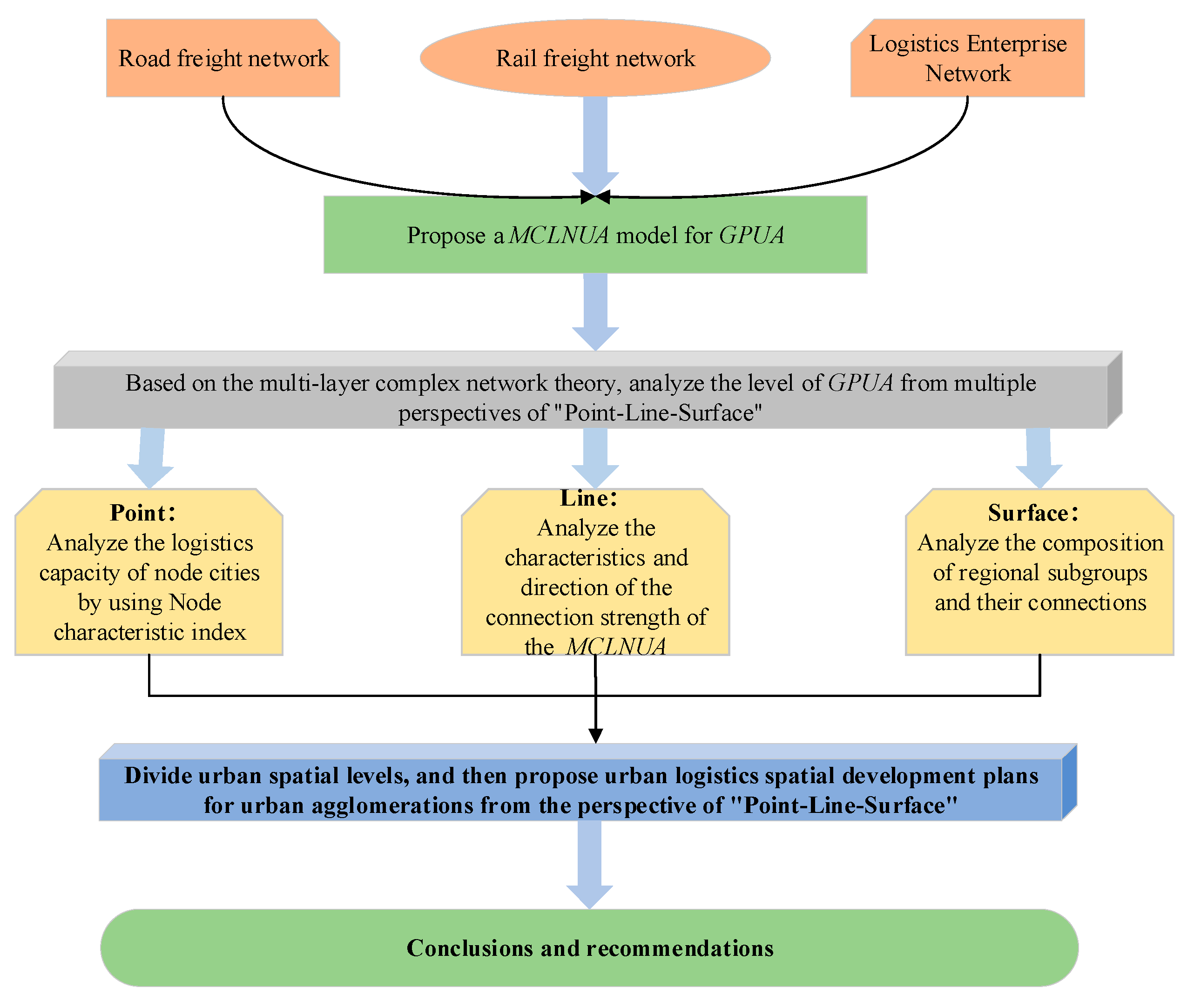
Evaluating each city’s logistics development level is important for advancing integrated regional development and further encouraging sustainable urban development. This study’s findings provide a complete assessment for evaluating the development level of each node city in the MCLNUA.

4.1. Analysis of Node Characteristic Index of MCLNUA

4.1.1. Node Centrality Analysis

The WDC reflects the local characteristics of the network, and the WCC reflects the global characteristics of the network. This study calculates the WDC and WCC of each city in the GPUA, and then ranks the results. 
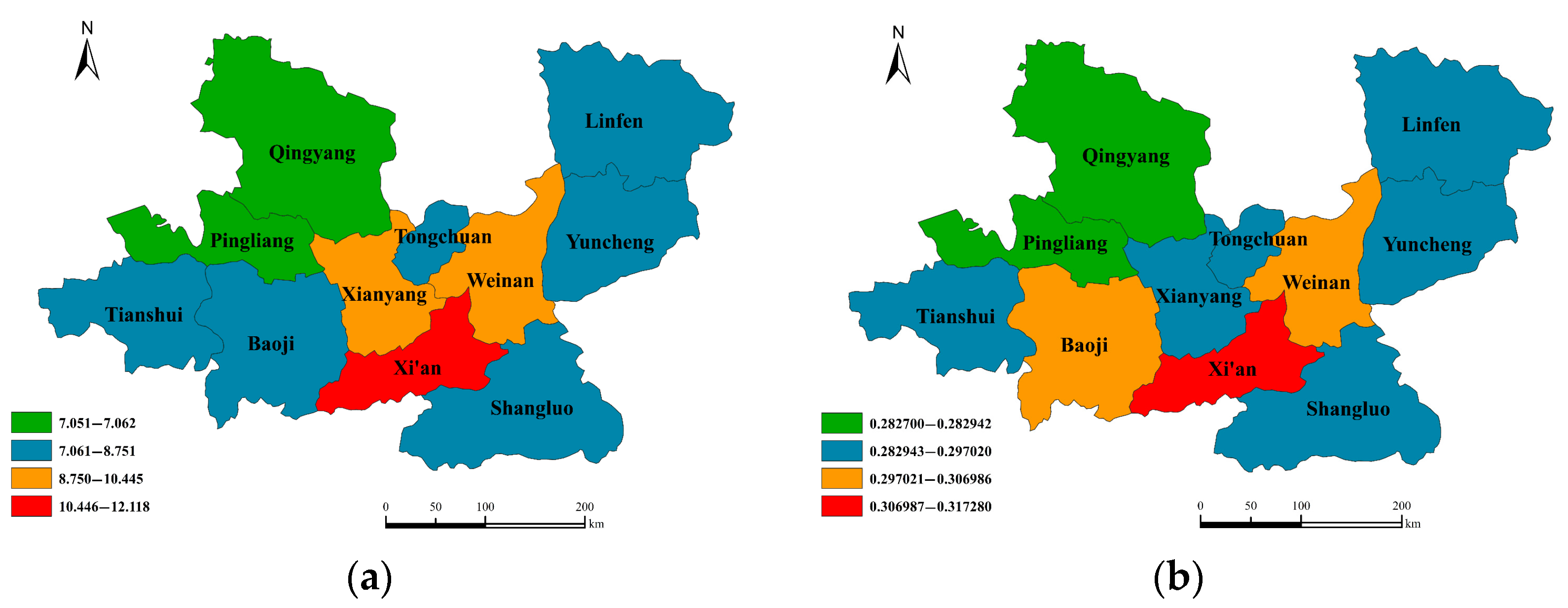
Table 4 shows the numerical ranking of each city index, and Figure 5 shows the regional distribution of urban centrality indicators.
The WDC intuitively reflects the possibility of a direct connection between a city and other cities in the MCLNUA. A greater WDC value for a city indicates a closer connection between the node and other nodes in the network. Xi’an has the largest WDC value (12.1178) and is the core city in the GPUA. The WDC values for Xianyang, Weinan, and Baoji exceed 8.7. The WDC values of Shangluo, Pingliang, and Qingyang are all less than 8.0, indicating that these cities are weakly connected with other cities in the GPUA. The standard deviation of the WDC value is 1.432, indicating that the logistics development level of cities in the network differ significantly.
The WCC refers to the degree to which a city is located in the center of the MCLNUA and reveals the relative reachability of the node. A node with a larger WCC value is at the center of the overall network. The WCC value of a city is consistent with its geographic location. For example, Xi’an, Weinan, and Baoji are located in the overall center of the GPUA and have relatively high WCC values. The WCC values of cities in the GPUA gradually decrease from the center to the edge, based on the geographical location of each city in the MCLNUA. The WCC values of the edge cities in the GPUA are close to 0.28. The standard deviation of the city WCC value is 0.01, indicating that the logistics network has good accessibility.
In general, Xi’an, Xianyang, and Weinan have a relatively high logistics development level, and strongly influence the logistics network in the GPUA. However, Shangluo, Pingliang, and Qingyang have a relatively low logistics development level. The values of several basic indexes illustrate that the edge cities in the GPUA are less affected by the radiation from the central city. Figure 6 shows that the regions with a larger node characteristic index value are consistently in the center of the GPUA, with significant variations in the level of logistics development between cities. The logistics development levels of the cities have not broken through the restrictions of provincial administrative regions to achieve good logistics interaction.

4.1.2. Node Influence Analysis

Cities are not independent in the network. Identifying the influence of nodes is important when developing a reference for urban logistics planning. The influence of each node city in the GPUA is calculated using the CDA, shown in Table 5.
The results show that Xi’an is not the most influential node city for logistics when considering the INV results in the GPUA. Rather, the most influential city is Xianyang, which is geographically close to Xi’an. In terms of urban functions, Xianyang is a core component of the international metropolis of Xi’an and has the most potential for development. Weinan and Baoji are node cities with high INV values. Geographically, Baoji is west of Xi’an, adjacent to Xi’an and Xianyang. Weinan is northeast of Xi’an and is strongly radiated by Xi’an. Weinan serves as an important logistics connection point between Xi’an and other cities and is a candidate to become an important sub-hub logistics city in the GPUA.
Linfen, Qingyang, and Pingliang have the smallest influence values in the GPUA. For Linfen, the INV value is low, but the centrality value is high. This illustrates that Linfen’s logistics development level is relatively high, but its impact on the entire network is low in the GPUA. Qingyang is in the southwestern direction of the GPUA. It is far from the core city and is weakly affected by the central city. Pingliang is northwest of the GPUA and is positioned at a different provincial level with Xi’an. It has a lower central degree value and a lower logistics development level.
In general, the INV value of each city in the GPUA is different. The INV value of the city in the central area is significantly higher compared to the INV values of the cities in the peripheral area in the GPUA, which shows polarization characteristics. The overall logistics development level of the GPUA has not achieved integrated development across the region.

4.2. Analysis of Connection Strength and Direction of MCLNUA

Figure 7a shows the connection strengths across the MCLNUA. The main logistics connections of cities remain concentrated in individual provinces, with relatively weak inter-provincial connections. From the perspective of the spatial structure characteristics of the network connection, the overall network connection is stronger in the south than that in the north, and stronger in the east than that in the west. There is a clear edge effect of the cities in the GPUA, with a weak logistics connection between the marginal cities and other cities in the GPUA.
Figure 7b shows the primary direction of logistics flows in the MCLNUA. Pingliang’s primary direction is Tianshui, and the primary direction of other cities in the GUPA is Xi’an. In addition, the primary direction of Xi’an points to Xianyang, and has clear geographical proximity. The primary direction of the marginal cities remains towards Xi’an, and the primary direction of the marginal cities is not close to the middle city geographically. This indicates that the radiation role of Xi’an has not been maximized, and the logistics cities are polarized.

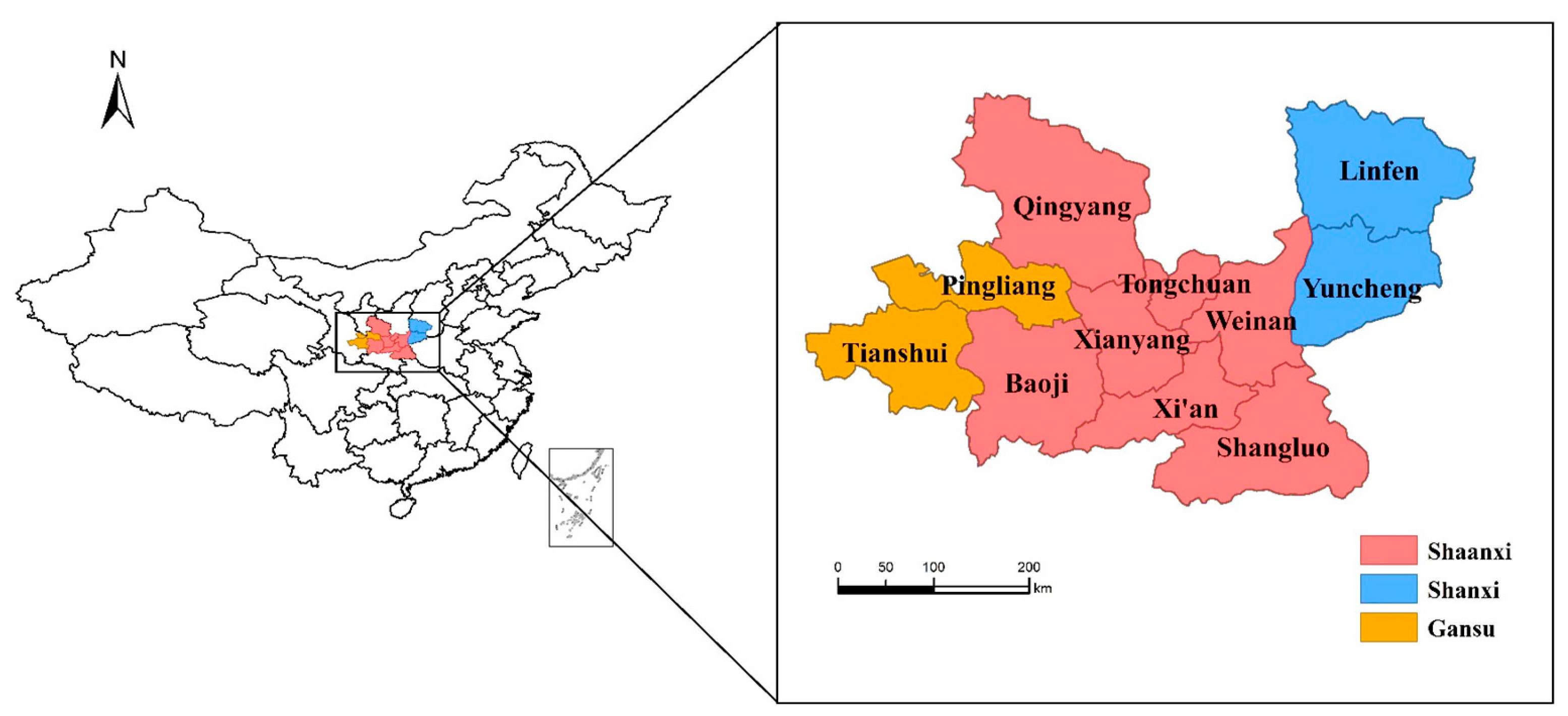
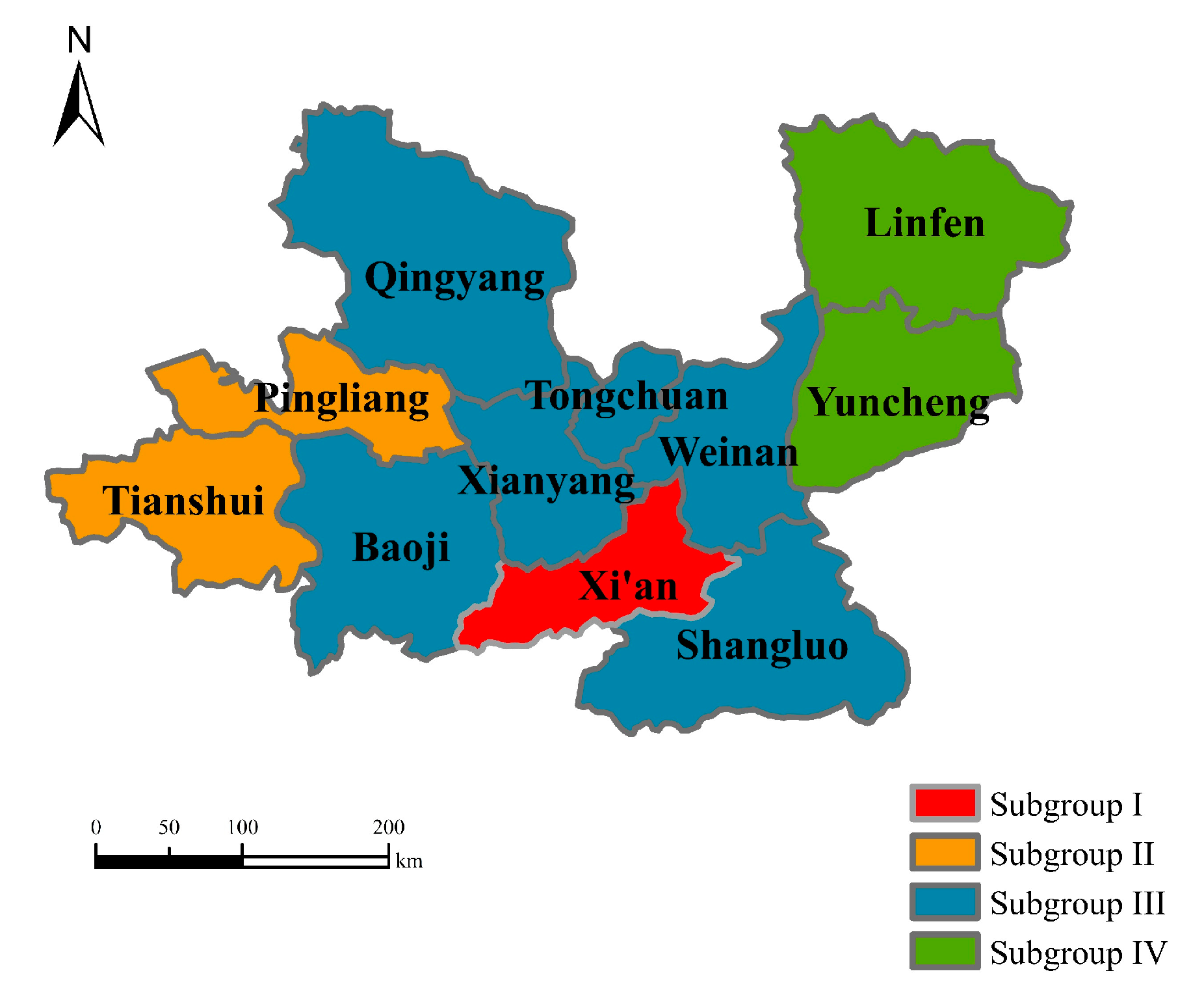
4.3. Analysis of Cohesion Subgroups of MCLNUA

This study used Ucinet software to divide the cities in the GPUA into different cohesion subgroups and to describe the composition of subgroups in the MCLNUA. The MCLNUA of the GPUA is divided into four cohesion subgroups (i.e., I, II, III, IV) by the Concor algorithm (L, 1968) in Ucinet software. Combined with the analysis of the regional geographic location, Figure 8 shows the regional distribution of cohesion subgroups. The cities in each cohesion subgroup show high geography proximity.
The cities in the MCLNUA are not in the same position and have a different degree of connection density with other cities. The cities that form a cohesion subgroup are closely related to each other, and there is a close logistics connection between the cities. The correlation density coefficient shows a more intuitive tendency and degree of affinity between cohesion subgroups. The density coefficients in the cohesion subgroups were analyzed to explore the relationship within the subgroups or between the subgroups. Table 5 shows the connection strength between the subgroups. A larger density coefficient value is associated with a closer connection within the subgroups or between the subgroups.
The numbers on the diagonal line in Table 6 represent the internal density coefficient of each subgroup. The internal density coefficient value of subgroup IV is the largest among the subgroups, reaching 11.90. This indicates there are frequent and close logistics resource interactions between cities in subgroup IV. The internal connection density values of subgroups III and II are 6.919 and 6.340, respectively. This indicates that a low closeness level of the internal connection between subgroup III and II, indicating they have not maximized the advantages of geographical proximity. The density of logistics connections in entire subgroups gradually decreases from the eastern region to the western region.
From the perspective of the connection density coefficient between different subgroups, the maximum density coefficient between subgroups is seen with subgroup I and subgroup III, reaching 18.470. The cities in subgroup III are geographically close to Xi’an, providing more logistics resources to interact with Xi’an. The cities in subgroup IV, Linfen and Yuncheng, are geographically far from Xi’an, however, their logistics connections with subgroup I are very close. The density coefficient between subgroup IV and subgroup I is 11.005, indicating these two subgroups have a pulling effect on each other’s logistics development [69]. Xi’an is the city with the most intensive exchange and diffusion of logistics resources in the GPUA and has an advantage in controlling the exchanges and connections between other subgroups. Overall, Xi’an has a stronger radiation influence on the eastern region compared to the western region in the GUPA.
There is an overall high level of connection between subgroup I, composed of Xi’an and other subgroups. However, the strength of connection between other subgroups is lower compared to Xi’an. There are significantly different density coefficients between the subgroups in the GPUA. The overall density coefficient gradually decreases from east to west.

4.4. Urban Logistics Space Development Planning of GPUA

This study applied the natural breakpoint method [64] to divide the cities in the GPUA into four levels according to node strength. This served as the basis for the regional division. The first level cities are central cities, the second level cities are sub-central cities, the third level cities are in the core areas, and the fourth level cities are the radiation affected cities (see Table 7). Based on the urban logistics connection and spatial hierarchy of the GPUA, this study provides recommendations for improving the logistics spatial development layout of the urban agglomeration based on the analysis and evaluation of urban logistics capabilities.
  • Point—Analysis of node city hierarchy
The specific city hierarchy is as follows. First, according to the division of urban spatial hierarchy, Xi’an is divided into a central logistics city in the GPUA. Xi’an has a strong cultural history and economic and cultural strength. It maintains the function of a logistics center and occupies a leading position in the development of urban logistics. However, the regional radiation ability in the GPUA is not strong, and the interaction of Xi’an with other cities could be enhanced.
Second, Xianyang and Weinan are divided into sub-central cities. The two cities have close logistics connections with surrounding cities, and the Xi’an–Xianyang integration strategy is being implemented. The logistics development level of Xianyang is rapidly improving, which should not be underestimated.
Third, the core area is composed of 6 cities, headed by Baoji and including Tianshui, Linfen, Yuncheng, Shangluo, and Tongchuan. These cities have not maximized the advantage of the positive impact created by the logistics development of surrounding central cities and sub-central cities.
Finally, Pingliang and Qingyang are identified as radiation-affected areas and are in poor locations with low economic development levels and unsatisfactory factor flow intensity. They have become valley areas with respect to logistics development in the GPUA.
2.
Line—Analysis of logistics development axis
The “Guanzhong Plain Urban Agglomeration Development Plan”, approved by the State Council of China in 2018, proposed the construction of a spatial pattern of “one circle, one axis, and three belts”. The study found that the central city (Xi’an) is connected with the sub-central city (Xianyang and Weinan) and its close core cities (Shangluo, Yuncheng, Linfen, and Tongchuan) to form a key logistics development axis. The central city (Xi’an) connects with the remaining core cities (Baoji and Tianshui) to form a sub-key logistics development axis. Table 8 shows two key logistics development axes, “Tongchuan–Xianyang–Xi’an-Shangluo” and “Xi’an–Weinan–Yuncheng–Linfen”, and one sub-key logistics development axis, “Tianshui–Baoji–Xi’an”. These comprehensively improve the city’s logistics development level in the GPUA.
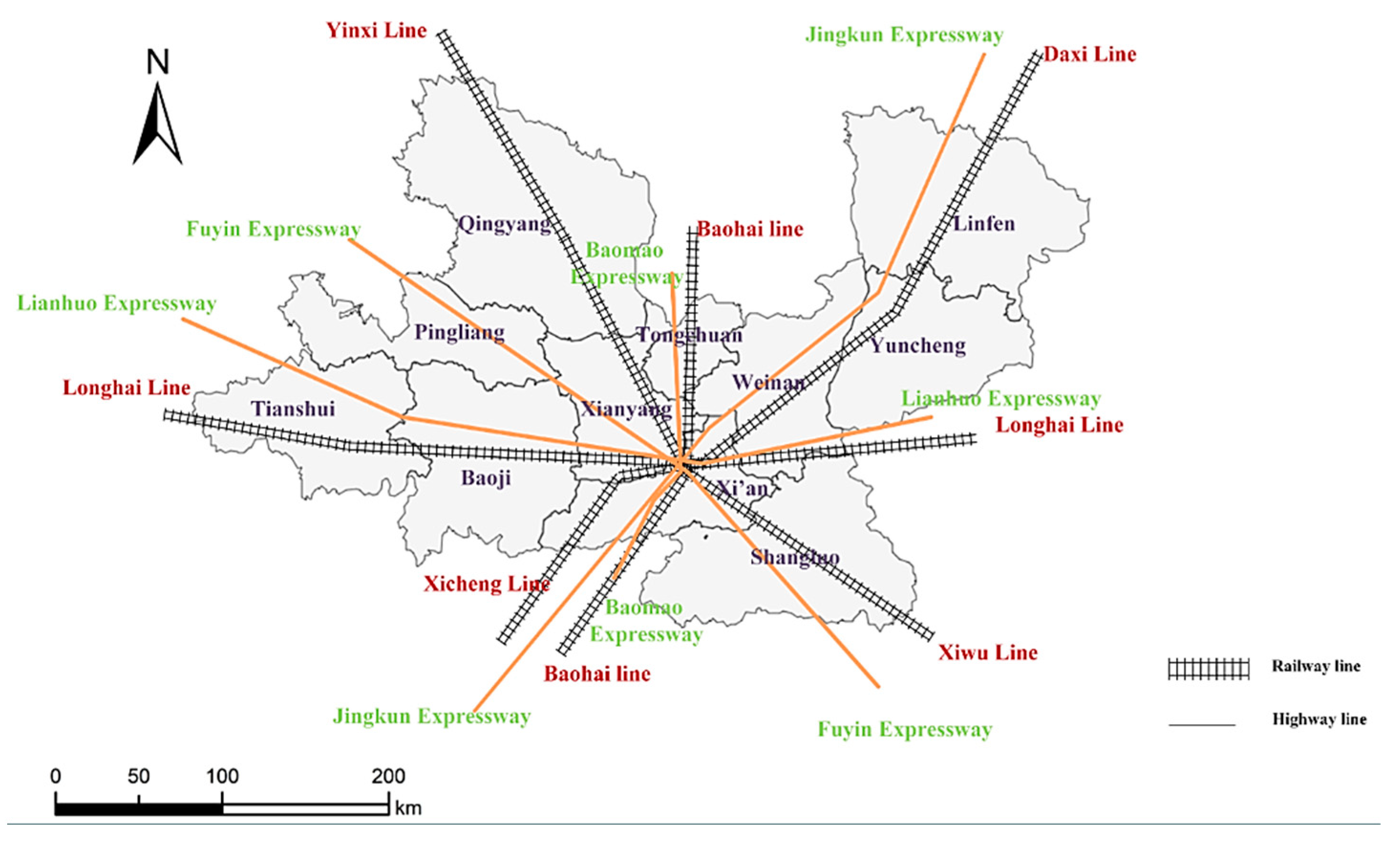
Figure 9 shows the urban logistics space development plan of the GPUA. The key logistics development axis of “Xi’an–Weinan–Yuncheng–Linfen” relies on the Beijing–Kunming Expressway and Daxi–Xicheng high-speed railway to strengthen the logistics development level of Yuncheng and Linfen. The key logistics development axis of “Tongchuan–Xianyang–Xi’an–Shangluo” connects the vertical direction of urban development, and relies on the Baomao Expressway, Fuyin Expressway, Baohai High Speed Rail, and Yinxi–Xiwu High Speed Rail. The “Tianshui–Baoji–Xi’an” sub-key logistics development axis relies on the infrastructure of the Longhai Railway and Lianhuo Expressway to continuously strengthen logistics connectivity. This enables the western region to better implement the radiation role of Xi’an. Figure 10 provides a schematic diagram of the relevant highway and railway lines. Relying on the logistics development axis improves the pattern of a strong east and weak west, and a strong south and weak north when developing urban agglomeration logistics.
3.
Surface—Analysis of the development of city groups
Mutual cooperation between cities avoids resource waste and supports sustainable and integrated urban development. This study divides the cities in the GPUA into the “Xi–Xian–Tong–Qing” city group, the “Wei–Shang–Lin–Yun” city group, and the “Bao–Ping–Tian” city group. These divisions were based on the analysis above of the urban logistics development level in the GPUA from different dimensions, and the urban spatial pattern described in the “Guanzhong Urban Agglomeration Urban Development Plan”. The first two are key city groups, and the latter is the sub-key city group, as shown in Figure 10.
First, Tongchuan and Xianyang are geographically similar to Xi’an. Xianyang, Tongchuan, and Qingyang belong to the same subgroup in the cohesive subgroup analysis above, so the four cities are in the same city group. This would facilitate improvements in the logistics development level of the core cities and its radiating areas of influence, expand the radiating influence of the core city of Xi’an, and advance logistics development for Qingyang.
Second, Linfen, Yuncheng, Weinan, and Shangluo in the east part of the GPUA are in the same city group. Yuncheng and Linfen are in the same province making the logistics connections between the two cities relatively close. Weinan and Shangluo are in the same cohesive subgroup and are adjacent to Yuncheng and Linfen. It would be more beneficial for Weinan to further develop its logistics capability compared to the other three cities and to better play the role of a sub-central city.
Finally, Tianshui, Pingliang, and Baoji are in the same city group. This is because Tianshui and Pingliang belong to the same cohesive subgroup. While Tianshui and Pingliang are in the same province, there is only a weak connection between the cities. Baoji has a superior geographical location and large potential for logistics development, supporting the city’s ability to maximize its advantages to drive logistics development in Tianshui and Pingliang, and further encourage the overall coordinated development of urban logistics.

5. Conclusions and Recommendations

This study evaluated the urban logistics development level of the GPUA based on complex network theory. The following diverse elements were considered: flow elements of the external connections of urban logistics (inter-city road freight volume), facility elements (inter-city railway lines), and functional elements (logistics enterprise connections). The development level of urban logistics was also evaluated from the multiple dimensions of “point–line–surface”. As mentioned above, we have constructed a more comprehensive urban logistics network, which allows us to more scientifically describe the logistics attributes of a city and to evaluate the level of logistics development of urban agglomerations in this way. The research results improve upon past results that considered a single element and extend our understanding of methods for evaluating the logistics development level of an urban environment. In addition, the study offers a new way to improve the evaluation system of logistics networks. The main conclusions of this study are as follows:
First, in terms of node characteristic indicators in the logistics network of the GPUA, Xi’an ranks high in centrality and is in the core position of the GPUA. There are significant differences between the logistics development level of Xi’an and the level of other cities. Cities with high characteristic index values are generally concentrated in the center of the GPUA. In contrast, cities in the periphery have significant edge effects and lower logistics development levels. Xianyang, Weinan, and Baoji are the three cities with the most potential to develop into a sub-central hub. To encourage the joint development of cities in the region, it is important to strengthen the leading role of sub-hub cities in driving edge cities.
Second, the strength of the logistics connections between cities in the GPUA is significantly restricted by administrative boundaries, with relatively weak inter-provincial connections. The structure of the overall network is stronger in the south than in the north, and stronger in the east than in the west. Xi’an has a high level of economic development and is located in the geographic center of the GPUA. The primary action direction for marginal cities is towards Xi’an, not the intermediate cities that are geographically close to itself in the MCLNUA. This shows that with respect to the flow of logistics elements, elements usually point to cities with high levels of economic development and geographical centers.
Third, cities tend to have logistics connections with surrounding cities. The density coefficient of logistics connections within the subgroups shows a decreasing trend from the eastern region to the western region, with significant differences. Additionally, cities in the subgroups have significant geographic proximity, with provincial scope characteristics.
Accordingly, the corresponding recommendations are as follows:
First, it is recommended that the core position of Xi’an be improved in logistics networks. This includes coordinating the internal logistics connections of the GPUA, and fully exerting the core role of Xi’an. This would involve constructing a hierarchical transmission mechanism ranging from Xi’an to surrounding areas and then to peripheral areas. This would enable the surrounding areas of Xi’an to become a key node in the logistics network of the GPUA. This strategy of driving logistics development in surrounding cities may also continuously improve the weak core position of Xi’an.
Second, by relying on the two key logistics development axes of “Tongchuan–Xianyang–Xi’an–Shangluo” and “Xi’an–Weinan–Yuncheng–Linfen”, and the sub-key logistics development axis of “Tianshui–Baoji–Xi’an”, management departments should establish a more intensive infrastructure network to increase the direct route between the fringe area and the core city [70], while also strengthening the connections around the area. This solution would help break the restrictions of administrative regions, reduce the infrastructure gap between cities, and advance logistics connections between cities. In particular, the logistics connections between Qingyang, Pingliang, and other surrounding cities should be strengthened, to comprehensively encourage the multi-directional development of the logistics level of the GPUA.
Third, by focusing on the “Xi–Xian–Tong–Qing” city group, the “Wei–Shang–Lin–Yun” city group, and the “Bao–Ping–Tian” city group, the government should actively guide connections between the city groups to encourage the joint development level of urban logistics. This would accelerate the formation of a development pattern where the sub-central city and Xi’an help each other, and truly realize the integrated development of regional logistics in the GPUA.
Considering the single attribute and the group attributes of the city, the complex network evaluation methodology can evaluate the logistics development at the level of urban agglomeration, and also simultaneously fulfil the research of the logistics development level of individual cities in the urban agglomeration. Based on complex network theory, this study positioned cities as nodes to investigate the logistics development level in the GPUA using a “point–line–surface” dimension. The results provide useful references for government officials to develop policies, achieve the integrated development of regional logistics, and advance the sustainable development of cities.
However, the scope of this research study was limited due to data availability. In the future, more research funding and data access may enable the expansion of the research field, to include multiple urban agglomerations or to cover all of China (e.g., Beijing–Tianjin–Hebei urban agglomeration, Yangtze River Delta urban agglomeration), while verifying the scalability of the model through obtaining more data and analyzing more cases.
In addition, this study explored the development level of urban node logistics but did not deeply analyze the dynamic evolutionary process and essential mechanism of the logistics network involved in an urban agglomeration. Future studies should consider the use of complex network theory to explore the structural evolution mechanism and dynamic mechanism of the logistics network for urban agglomerations. Despite these limitations, this study adds value to the sustainable development of urban logistics by evaluating the level of urban logistics from multiple dimensions.

Author Contributions

F.M. established the research framework; Z.Y. drafted the manuscript and contributed to the materials and analysis; Z.Y., S.Z., H.H., and Z.S. carried out the result calculations; F.M., Z.Y., S.Z., K.F.Y., Q.S., and P.L. revised the manuscript together. All authors have read and agreed to the published version of the manuscript.

Funding

This research was supported by the National Social Science Foundation of China [grant number 18BGL258], Natural Science Basic Research Program of Shaanxi [grant number 2022JM-423], Scientific Research Plan Project of Shaanxi Provincial Department of Education [grant number 21JP007], Social Science Fund Major Project of Xi’an [grant number 22GL89].

Conflicts of Interest

The authors declare that there is no conflict of interest regarding the publication of this paper.

References

  1. Song, Q.; Xie, Z.; Li, T.; Liu, J.; Feng, C.a.; Zhang, Y. Study on Spatial Structure of Urban Network in Urban Agglomeration in the Middle Reaches of the Yangtze River. Areal Res. Dev. 2017, 36, 59–65. [Google Scholar]
  2. Hussain, S. The Connected City: How Networks are Shaping the Modern Metropolis. Int. Dev. Plan. Rev. 2013, 35, 306. [Google Scholar]
  3. Su, X.; Zheng, C.; Yang, Y.; Yang, Y.; Zhao, W.; Yu, Y. Spatial Structure and Development Patterns of Urban Traffic Flow Network in Less Developed Areas: A Sustainable Development Perspective. Sustainability 2022, 14, 8095. [Google Scholar] [CrossRef]
  4. Qin, L. Study on the Characteristics and Evolution Theory of Urban Logistics Spatial Structure. Ph.D. Thesis, Beijing Jiaotong University, Beijing, China, 11 June 2012. [Google Scholar]
  5. Banomyong, R.; Thai, V.V.; Yuen, K.F. Assessing the National Logistics System of Vietnam. Asian J. Shipp. Logist. 2015, 31, 21–58. [Google Scholar] [CrossRef]
  6. Zou, X.; Somenahalli, S.; Scrafton, D. Evaluation and analysis of urban logistics competitiveness and spatial evolution. Int. J. Logist.-Res. Appl. 2020, 23, 493–507. [Google Scholar] [CrossRef]
  7. Bookbinder James, H.; Tan Chris, S. Comparison of Asian and European logistics systems. Int. J. Phys. Distrib. Logist. Manag. 2003, 33, 36–58. [Google Scholar] [CrossRef]
  8. Liu, C.J.; Zhou, J.P.; Jiang, J.H. Research on Spatial Connection Characteristics and Driving Mechanism of Regional Logistics in the Yangtze River Economic Belt. East China Econ. Manag. 2019, 33, 87–96. [Google Scholar]
  9. Chen, Y.C.; Zhang, M.Y.; Zhang, Y.H. Evaluation of the development level of low-carbon logistics in Beijing. Environ. Eng. Manag. J. 2015, 14, 1829–1836. [Google Scholar]
  10. Tian, X.; Zhang, M. Research on Spatial Correlations and Influencing Factors of Logistics Industry Development Level. Sustainability 2019, 11, 1356. [Google Scholar] [CrossRef]
  11. Lv, P.; Wang, Y.; Xu, F.W. Research on Evaluation System of City Logistics Development Level. Logist. Supply Chain Res. China 2010, 116028, 320–327. [Google Scholar]
  12. Wan, F.J. Study on Logistics Capability Evaluation of Wuhan City Circle based on Principal Component Analysis. In Advances in Applied Sciences and Manufacturing, Pts 1 And 2; Wang, Y., Si, H., Su, Y., Xu, P., Eds.; Trans Tech Publications Ltd.: Stafa-Zurich, Switzerland, 2014; Volume 850–851, pp. 994–997. [Google Scholar]
  13. Lan, S.; Yang, C.; Huang, G.Q. Data analysis for metropolitan economic and logistics development. Adv. Eng. Inform. 2017, 32, 66–76. [Google Scholar] [CrossRef]
  14. Li, D.Q.; Zhao, L.J.; Wang, C.C.; Sun, W.J.; Xue, J. Selection of China’s imported grain distribution centers in the context of the Belt and Road initiative. Transp. Res. Part E Logist. Transp. Rev. 2018, 120, 16–34. [Google Scholar] [CrossRef]
  15. Liu, H.H. The Evaluation on Logistics Development Level Based on the Principal Component and Cluster Analysis; Aussino Acad Publ House: Marrickville, Australia; Taiyuan, China, 2009; pp. 348–353. [Google Scholar]
  16. Hu, X.Q.; Wang, C.; Wu, J.J.; Stanley, H.E. Understanding interurban networks from a multiplexity perspective. Cities 2020, 99, 13. [Google Scholar] [CrossRef]
  17. Matsumoto, H. International air network structures and air traffic density of world cities. Transp. Res. Part E Logist. Transp. Rev. 2007, 43, 269–282. [Google Scholar] [CrossRef]
  18. Tsekeris, T. Interregional trade network analysis for road freight transport in Greece. Transp. Res. Part E Logist. Transp. Rev. 2016, 85, 132–148. [Google Scholar] [CrossRef]
  19. Jin, F.; Wang, C. Hub-and-Spoke System and China Aviation Network Organization. Geogr. Res. 2005, 24, 774–784. [Google Scholar]
  20. Feng, X.; Xiu, C.; Liu, Z.; Ma, L.; Li, X. Characteristics of Urban Network Hierarchy Evolution Based on the Perspective of Railway Passenger Transport in Northeast China. Sci. Geogr. Sin. 2018, 38, 1430–1438. [Google Scholar]
  21. Gao, X.; Xiu, C.L.; Wei, Y.; Liang, Z.M. Study on the network of districts and counties in Chongqing based on the date of the highway cargo flows. Hum. Geogr. 2016, 31, 73–80. [Google Scholar]
  22. Kechagias, E.P.; Gayialis, S.P.; Konstantakopoulos, G.D.; Papadopoulos, G.A. An application of an urban freight transportation system for reduced environmental emissions. Systems 2020, 8, 49. [Google Scholar] [CrossRef]
  23. Joyez, C. On the topological structure of multinationals network. Phys. A Stat. Mech. Its Appl. 2017, 473, 578–588. [Google Scholar] [CrossRef]
  24. He, M.L.; Zeng, L.; Wu, X.H.; Luo, J.Q. The Spatial and Temporal Evolution of Logistics Enterprises in the Yangtze River Delta. Sustainability 2019, 11, 5318. [Google Scholar] [CrossRef]
  25. Zong, H.; Lyu, R. The Spatial Characteristics and Evolution of Chinese Urban Network Based on Logistics Enterprise Data in 2007–2017. Sci. Geogr. Sin. 2020, 40, 760–767. [Google Scholar]
  26. Wu, T.; Wang, J. Multi-scale Analysis and Development Evaluation of Logistics Hub Cities Based on Multi-layer Complex Networks. J. Transp. Syst. Eng. Inf. Technol. 2019, 19, 33–39. [Google Scholar]
  27. Ding, R.; Ujang, N.; Hamid, H.B.; Manan, M.A.S.; Li, R.; Albadareen, S.S.M.; Nochina, A.; Wu, J. Application of complex networks theory in urban traffic network researches. Netw. Spat. Econ. 2019, 19, 1281–1317. [Google Scholar] [CrossRef]
  28. Gao, S.; Xin, X.; Li, C.; Chen, K. Container ocean shipping network design considering carbon tax and choice inertia of cargo owners. Ocean. Coast. Manag. 2022, 216, 105986. [Google Scholar] [CrossRef]
  29. Pais Montes, C.; Freire Seoane, M.J.; González Laxe, F. General cargo and containership emergent routes: A complex networks description. Transp. Policy 2012, 24, 126–140. [Google Scholar] [CrossRef]
  30. Ge, S.; Yao, H.; Lian, B. Research on the structure of air logistics network under the geospatial perspective of " Belt and Road Initiative". Logist. Sci. Technol. 2021, 44, 86–92. [Google Scholar]
  31. Bombelli, A.; Santos, B.F.; Tavasszy, L. Analysis of the air cargo transport network using a complex network theory perspective. Transp. Res. Part E Logist. Transp. Rev. 2020, 138, 101959. [Google Scholar] [CrossRef]
  32. Guo, J.; He, Y.; Hou, Y. Spatial connection and regional difference of the coastal container port shipping network of China. Prog. Geogr. 2018, 37, 1499–1509. [Google Scholar]
  33. Wang, W.; Huang, L.; Liang, X.D. On the Simulation-Based Reliability of Complex Emergency Logistics Networks in Post-Accident Rescues. Int. J. Environ. Res. Public Health 2018, 15, 79. [Google Scholar] [CrossRef]
  34. Wang, S.H.; Yang, Y.; Sun, L.Y.; Li, X.N.; Li, Y.X.; Guo, K.H. Controllability Robustness Against Cascading Failure for Complex Logistic Network Based on Dynamic Cascading Failure Model. Ieee Access 2020, 8, 127450–127461. [Google Scholar] [CrossRef]
  35. Calatayud, A.; Mangan, J.; Palacin, R. Vulnerability of international freight flows to shipping network disruptions: A multiplex network perspective. Transp. Res. Part E Logist. Transp. Rev. 2017, 108, 195–208. [Google Scholar] [CrossRef] [Green Version]
  36. Yang, Y.; Sun, B.F.; Wang, S.H.; Li, Y.X.; Li, X.N. Controllability Robustness Against Cascading Failure for Complex Logistics Networks Based on Nonlinear Load-Capacity Model. IEEE Access 2020, 8, 7993–8003. [Google Scholar] [CrossRef]
  37. Olariaga, O.D.; Bolivar, N.; Gutierrez, R.M.; Rico Galeana, O. Gravitational analysis of the air transport network. Application to the case of Colombia. Transp. Res. Procedia 2018, 33, 51–58. [Google Scholar] [CrossRef]
  38. Ren, X.H.; Zhong, H.J.; Zhao, S.M. The measurement of the adsorption capacity and therelationship strength of the cities in the Central PlainsEconomic Zone—Based on the data of railway passenger train. Econ. Trade 2016, 3X, 234–236, 238. [Google Scholar]
  39. Taylor, P.J. Exploratory Analysis of the World City Network. Urban Stud. 2002, 39, 2367–2376. [Google Scholar] [CrossRef]
  40. Guler, H. An empirical modelling framework for forecasting freight transportation. Transport 2014, 29, 185–194. [Google Scholar] [CrossRef]
  41. Wang, L.; Ma, J.C.; Jiang, Z.Q.; Yan, W.F.; Zhou, W.X. Gravity law in the Chinese highway freight transportation networks. EPJ Data Sci. 2019, 8, 28. [Google Scholar] [CrossRef]
  42. Xu, M.; Pan, Q.; Xia, H.; Masuda, N. Estimating international trade status of countries from global liner shipping networks. R. Soc. Open Sci. 2020, 7, 200386. [Google Scholar] [CrossRef]
  43. Tsoulis, D.; Patlakis, K. A spectral assessment review of current satellite-only and combined Earth gravity models. Rev. Geophys. 2013, 51, 186–243. [Google Scholar] [CrossRef]
  44. Wang, L.; An, M.; Jia, L.M.; Qin, Y. Application of Complex Network Principles to Key Station Identification in Railway Network Efficiency Analysis. J. Adv. Transp. 2019, 2019, 1574136. [Google Scholar] [CrossRef]
  45. Zhang, H.; Cui, H.D.; Wang, W.; Song, W.B. Properties of Chinese railway network: Multilayer structures based on timetable data. Phys. A Stat. Mech. Its Appl. 2020, 560, 12. [Google Scholar] [CrossRef]
  46. Derudder, B.; Cao, Z.; Liu, X.J.; Shen, W.; Dai, L.; Zhang, W.Y.; Caset, F.; Witlox, F.; Taylor, P.J. Changing Connectivities of Chinese Cities in the World City Network, 2010–2016. Chin. Geogr. Sci. 2018, 28, 183–201. [Google Scholar] [CrossRef] [Green Version]
  47. Derudder, B.; Taylor, P.J.; Hoyler, M.; Ni, P.F.; Liu, X.J.; Zhao, M.X.; Shen, W.; Witlox, F. Measurement and interpretation of connectivity of Chinese cities in world city network, 2010. Chin. Geogr. Sci. 2013, 23, 261–273. [Google Scholar] [CrossRef]
  48. Akhavan, M.; Ghiara, H.; Mariotti, I.; Sillig, C. Logistics global network connectivity and its determinants. A European City network analysis. J. Transp. Geogr. 2020, 82, 9. [Google Scholar] [CrossRef]
  49. Sankar, C.P.; Thumba, D.A.; Ramamohan, T.R.; Chandra, S.S.V.; Kumar, K.S. Agent-based multi-edge network simulation model for knowledge diffusion through board interlocks. Expert Syst. Appl. 2020, 141, 10. [Google Scholar] [CrossRef]
  50. Boccaletti, S.; Bianconi, G.; Criado, R.; del Genio, C.I.; Gomez-Gardenes, J.; Romance, M.; Sendina-Nadal, I.; Wang, Z.; Zanin, M. The structure and dynamics of multilayer networks. Phys. Rep.-Rev. Sect. Phys. Lett. 2014, 544, 1–122. [Google Scholar] [CrossRef]
  51. Buldyrev, S.V.; Roni, P.; Gerald, P.; Eugene, S.H.; Shlomo, H. Catastrophic cascade of failures in interdependent networks. Nature 2010, 464, 1025–1028. [Google Scholar] [CrossRef]
  52. Sun, X.; Wu, Y.; Feng, X.; Xiao, J. Structure Characteristics and Robustness Analysis of Multi-Layer Network of High Speed Railway and Ordinary Railway. J. Univ. Electron. Sci. Technol. China 2019, 48, 315–320. [Google Scholar]
  53. De Bona, A.A.; de Oliveira Rosa, M.; Fonseca, K.V.O.; Lüders, R. A reduced model for complex network analysis of public transportation systems. Phys. A Stat. Mech. Its Appl. 2021, 567, 125715. [Google Scholar] [CrossRef]
  54. Wang, X.L.; Zhu, L.N.; Shi, Z.B. Multi-layer Route Aggregation Network Modeling and Correlation Analysis. Sci. Technol. Eng. 2020, 20, 1243–1249. [Google Scholar]
  55. Wang, D.J.; Zou, X.F. A new centrality measure of nodes in multilayer networks under the framework of tensor computation. Appl. Math. Model. 2018, 54, 46–63. [Google Scholar] [CrossRef]
  56. Liu, P.C. The Evolution Analysis and Modeling of Public Opinion Based on Online Social Network. Master’s Thesis, University of Electronic Science and Technology of China, Chengdu, China, June 2020. [Google Scholar]
  57. Li, X.; Sun, Q. Identifying and ranking influential nodes in complex networks based on dynamic node strength. Algorithms 2021, 14, 82. [Google Scholar] [CrossRef]
  58. Zhang, X.; Zhang, W.; Lee, P.T. Importance rankings of nodes in the China Railway Express network under the Belt and Road Initiative. Transp. Res. Part A Policy Pract. 2020, 139, 134–147. [Google Scholar] [CrossRef]
  59. Lin, P.; Weng, J.; Fu, Y.; Yin, B. Structure characteristics of rail transit weighted network based on smart card data. J. Jilin Univ. Eng. Technol. Ed. 2020, 50, 956–962. [Google Scholar]
  60. Brockmann, D.; Helbing, D. The Hidden Geometry of Complex, Network-Driven Contagion Phenomena. Science 2013, 342, 1337–1342. [Google Scholar] [CrossRef] [Green Version]
  61. Lin, Z.W.; Ye, F.H.; Chen, C.; Zheng, Z.B. BGN: Identifying Influential Nodes in Complex Networks via Backward Generating Networks. IEEE Access 2018, 6, 59949–59962. [Google Scholar] [CrossRef]
  62. Wang, Q.; Ren, J.D.; Wang, Y.; Zhang, B.; Cheng, Y.Q.; Zhao, X.L. CDA: A Clustering Degree Based Influential Spreader Identification Algorithm in Weighted Complex Network. IEEE Access 2018, 6, 19550–19559. [Google Scholar] [CrossRef]
  63. Changhong, M.; Haijiang, W. On the direction and intensity of urban economic contacts in Henan Province. Geogr. Res. 2006, 25, 222–232. [Google Scholar]
  64. Lin, X.Y.; Hu, Y.M.; Wang, G.X.; Fan, S.D. Analysis of functional connection and spatial pattern of Pearl River Delta urban agglomeration based on multi-element factor flows. World Reg. Stud. 2020, 29, 536–548. [Google Scholar]
  65. Sheng, K.; Yang, Y.; Zhang, H. Cohesive subgroups and underlying factors in the urban network in China. Geogr. Res. 2019, 38, 2639–2652. [Google Scholar]
  66. An, Y.; Liu, J.; Qiao, D. Urban Spatial Connection and Network Structure in Zhongyuan Urban Agglomeration: A Study Based on Integrated Traffic and Information Flow. Sci. Geogr. Sin. 2019, 39, 1929–1937. [Google Scholar]
  67. China Railway Map. Available online: http://cnrail.geogv.org/zhcn// (accessed on 27 January 2020).
  68. Top 100 Chinese Logistics Companies in 2018. Available online: http://www.transwinner.com/News/detail.html?id=5768/ (accessed on 10 February 2020).
  69. Wang, M.; Zhu, Z.Y. Social network analysis of economic and trade cooperation between China and countries along “the Belt and Road”. Stat. Decis. 2019, 35, 124–127. [Google Scholar]
  70. Shao, X.X.; Yao, Y.L. Characteristics of spatial networks and the influencing mechanism of the Middle Reaches of Yangtze River. Urban Probl. 2019, 10, 15–26. [Google Scholar]
Figure 1. The research framework.
Systems 10 00171 g001
Figure 2. The construction process of MCLNUA.
Systems 10 00171 g002
Figure 3. The CDA algorithm flow chart.
Systems 10 00171 g003
Figure 4. The study area.
Systems 10 00171 g004
Figure 5. The calculation process of the MCLNUA model.
Systems 10 00171 g005
Figure 6. Regional distribution of urban node characteristic indicators in the GPUA: (a) regional distribution of WDC; (b) regional distribution of WCC.
Systems 10 00171 g006
Figure 7. Diagram of connection strength and primary direction of MCLNUA: (a) connection strength of MCLNUA; (b) primary direction of MULNUA.
Systems 10 00171 g007
Figure 8. Regional distribution of cohesion subgroups.
Systems 10 00171 g008
Figure 9. The layout of urban logistics space development planning in the GPUA.
Systems 10 00171 g009
Figure 10. The layout of main highways and railways in the GPUA.
Systems 10 00171 g010
Table 1. A comparison of comprehensive evaluation methods.
MethodScope of ApplicationPros and Cons
Entropy methodLower dimensional data, clearer evaluation indicators, single attribute dataAn objective evaluation method that avoids bias caused by human factors. Possible distortion of weights and invalid results
Principal component analysis (PCA) and cluster methodsHigher dimensional data, strong connections between variables, data classification, single attribute dataAchieve data dimensionality reduction. Convenient calculation and operation. Loss of some effective data
Complex network theoryHigher dimensional and complex data, data with network structure, multi-attribute dataA comprehensive evaluation method, ability to consider connections between data, and require clear data structures. Requirements for data quality are high
Table 2. The meaning of sub-network and node.
VariableSub-NetworkThe Meaning of Node
G s 1 Road freight networkThe city where entities stop for loading and unloading during road freight
G s 2 Railway freight networkThe city where a freight station is located for loading and unloading goods
G s 3 Logistics enterprise networkThe city where the logistics company is located
Table 3. The edge weight of network connection and calculation method.
VariableMeaningCalculation Method
W s 1 Road freight network edge weightGravity model [37,40,41,42,43]
W s 2 Rail freight network edge weightNumber of railway freight lines [36,44,45]
W s 3 Logistics enterprise network edge weightInterlocking network model [39,46,47,48,49]
Table 4. The sorting of the node characteristic index values.
No.Weighted Degree Centrality (WDC)Weighted Closeness Centrality (WCC)
1Xi’an12.118Xi’an0.317
2Xianyang10.445Weinan0.307
3Weinan9.880Baoji0.301
4Baoji8.750Linfen0.297
5Linfen8.577Tianshui0.295
6Yuncheng8.459Xianyang0.295
7Tongchuan8.348Yuncheng0.294
8Tianshui8.157Tongchuan0.294
9Shangluo7.808Shangluo0.289
10Pingliang7.062Qingyang0.283
11Qingyang7.051Pingliang0.283
Standard deviation1.4370.010
Table 5. The ranking list of INV of cities.
Rank123456
CityXianyangWeinanXi’anBaojiYunchengTongchuan
INV398.9357.8352.7282.5264.5257.8
Rank7891011
CityTianshuiShangluoLinfenQingyangPingliang
INV246.5226.5208.0186.3116.4
Table 6. The density coefficient of cohesion subgroups.
Cohesion SubgroupsIIIIIIIV
I/7.00518.47011.005
II7.0056.3405.6535.470
III18.4705.6536.9196.452
IV11.0055.4706.45211.900
Table 7. Classification of city levels in the GUPA.
LevelCityCity Hierarchy
First levelXi’anCentral city
Second levelXianyang, WeinanSub-central city
Third levelBaoji, Tianshui, Linfen, Yuncheng, Shangluo, TongchuanCore areas
Fourth levelPingliang, QingyangRadiation affected areas
Table 8. Logistics development axis in the GUPA.
No.Logistics Development Axis
1Key logistics development axisTongchuan–Xianyang–Xi’an-Shangluo
2Key logistics development axisXi’an–Weinan–Yuncheng–Linfen
3Sub-key logistics development axisTianshui–Baoji–Xi’an
Publisher’s Note: MDPI stays neutral with regard to jurisdictional claims in published maps and institutional affiliations.

