Reinventing Detroit: Reclaiming Grayfields—New Metrics in Evaluating Urban Environments


Abstract
: Planners, designers, citizens, and governmental agencies are interested in creating environments that are sustainable and fulfill a wide range of economic, ecological, aesthetic, functional, and cultural expectations for stakeholders. There are numerous approaches and proposals to create such environments. One vision is the 1934 “Broadacre City” proposed by Frank Lloyd Wright for the Taliesin, Wisconsin area that was never implemented. Frank Lloyd Wright's vision integrated transportation, housing, commercial, agricultural, and natural areas in a highly diverse pattern forming a vast urban savanna complex. He also applied his “Broadacre City” idea to the 1942 Cooperative Homesteads Community Project in Detroit, Michigan, another un-built project. This vision concerning the composition of the urban environment may be conceptually realized in the ongoing gray-field reclamation in suburban Detroit, Michigan. Recent science-based investigations, concerning the metrics to measure and evaluate the quality of designed spaces, suggest that this “Broadacre City” approach may have great merit and is highly preferred over past spatial treatments (p ≤ 0.05). These metrics explain 67 to 80% of the variance concerning stakeholder expectations and are highly definitive (p < 0.001).1. Introduction
Scholars, private practice professionals, citizens and governmental practitioners are all invested stakeholders in the planned and designed spatial composition of the environment. The criteria to maximize the use and fitness of this space have been demonstrated to be extensive and inclusive [1]. This means that the planning and design of the environment must be multi-functional to benefit and respective of economic, ecological, aesthetic, and cultural considerations [2]. Various authorities have labeled this planning and design approach “post post-modernism” (PPM), “context sensitive design” (CSD), or “context sensitive solutions” (CSS) [3].
One vision that fits into this inclusive PPM approach is the “Broadacre City” proposal by Frank Lloyd Wright where the environment is comprised of a mixture of landscape uses, including tall structures and agriculture to form both a pastoral and yet urban setting [4]. The ideas imbedded in Frank Lloyd Wright's proposal for the “Living City” were never realized but not forgotten. Recently, proposals for the reinvention and re-visioning Detroit's grayfields resemble Frank Lloyd Wright's landscape urbanism concepts. In addition, the latest environmental quality research suggests that respondents collectively assess the built landscape with an economic, ecological, aesthetic, and cultural lens, as well as assessing the typical functional requirements of a place [5]. This article presents the integration and application of a predictive environmental quality model to assess the ideas associated with the “Broadacre City/Living City” vision, emerging ideas to reinvent Detroit, and with past physical models for Detroit's urban landscape.
2. Pertinent Literature and Historical Overview
2.1. Broadacre City/Living City
Frank Lloyd Wright is primarily known for his architecture. However he had associations with Lewis Mumford, Jens Jensen and Walter Burley Griffin, as well as influences from Ossian Cole Simonds, which facilitated his perspective concerning integrated site design and architecture, urban design, and living systems [4]. In many respects his abilities to merge landscape and site were far beyond the abilities of his Bauhaus contemporaries. While in Europe, architects were enthusiastic about new materials, industrialization, and collaboration between structure and artists; their approach to landscape was minimal, simplistic, aesthetically mundane, and ecologically un-aware [6]. For example Corbusier's brilliant vision for the city of Paris treated the landscape as a uniform green forested sea where nothing really happened surrounding his monolithic buildings [7]. Although Corbusier understood the importance of biospheric features in the urban landscape, as he intended his massive buildings be hidden at the ground level by the urban forest [7]. Meanwhile in Japan, site and architecture were often married together as a couple, and Frank Lloyd Wright was sympathetic to this unified approach [4].
Frank Lloyd Wright was formatively influenced by his rural “upbringing”; and while he worked professionally in Chicago, he did not abandon his intimate understanding concerning the significance of the land and the numerous important functions that are associated with the land. Thus when he focused his attention upon urban design, his approach was quite similar to how many landscape architects develop landscape urbanism plans considering site hydrology, softscape spaces, recreation, circulation and way-finding, wildlife habitat, vegetation complexes, aesthetics, socialization, cultural identity, utility corridors, multiple land-uses, and building footprints. He was also inspired by Ebenezer Howard's “Garden City” ideas creating a decentralized city [4].
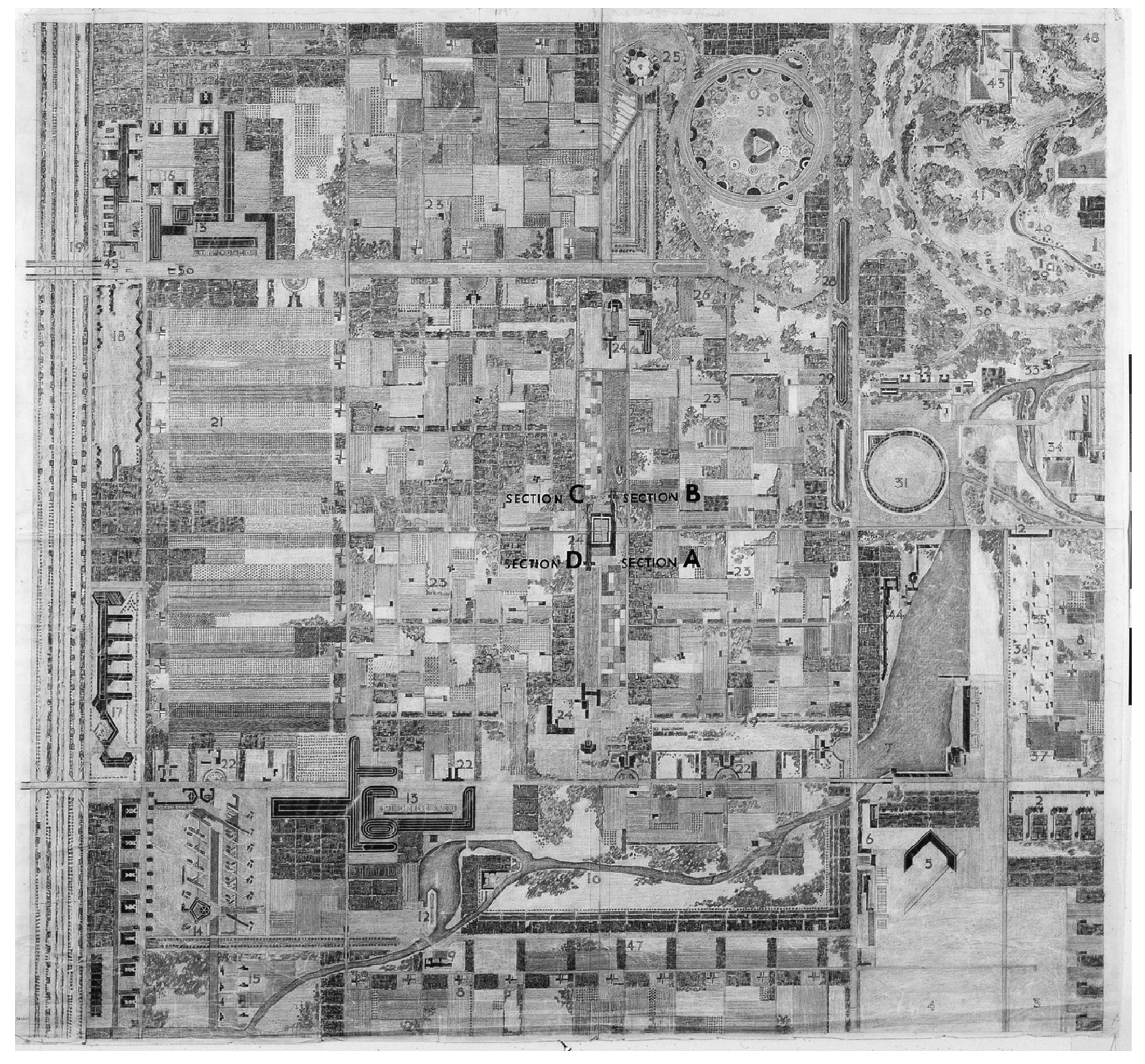
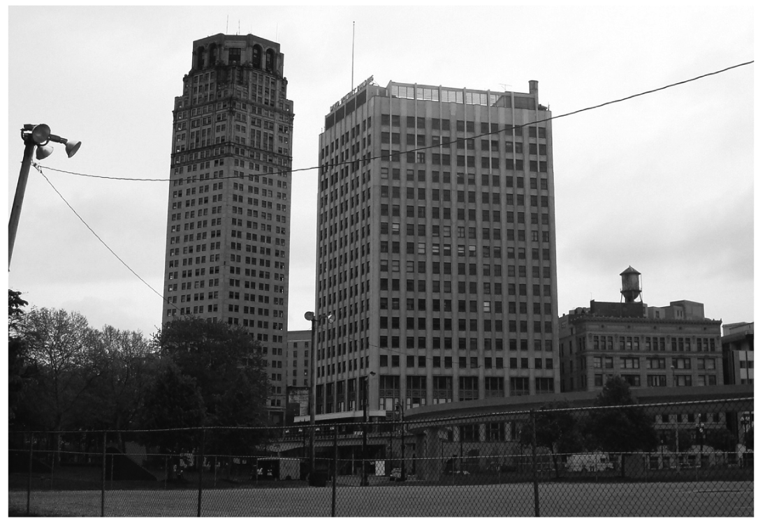
Wright employed the Taliesin area in Wisconsin to develop his plan and prepare sketches (Figure 1). A model was built of the plan and exhibited in 1935 [4]. Wright believed the city should be everywhere and yet nowhere [4]. Cities should be highway-less and highways should be without cities. Figure 2 illustrates a plan featuring his “Broadacre City.” Buildings could not cast shadows on other buildings. Land-uses were assigned to fit the land similar to what landscape architects were doing and would do when they developed new towns in Eastern United States such as Radburn, Greenbelt, and Reston and as popularized later by Ian McHarg [8,9]. This approach was far different than the obtrusive and self-indulgent architecture and urban design that occurred in much of the world during the 20th Century such as in Detroit, Michigan (Figure 3).
In 1942, Wright proposed a plan for the Cooperative Homesteads Community Project in the Detroit, Michigan area [4]. The design was an applied Broadacre City proposal [4]. His design for the structures included rammed-earth homes. The project was never built. Wright designed several other un-built and partially built community housing projects, such as Usonia I in East Lansing, Michigan, the Galesburg Country Houses in Galesburg, Michigan, know as “the Acres”, and Usonia II in Pleasantville, New York, of which Usonia II might be considered the most successful [4].
With the exception of visions shared by landscape architects, featuring many build projects such as Sea Ranch in California by the late Lawrence Halprin or the Valleys near Baltimore, Maryland, directed by Ian McHarg and David Wallace, the ideas expressed by Wright were rarely explored [10]. The decentralized city in many respects became a lost possibility. The city became a sea of architectural monuments competing for attention.
2.2. New Visions of Detroit
After the fire of 1805, the City of Detroit had its origins in a radiating French “goose-foot” design near the old fort, and radiating octagon plan for streets and city blocks, designed by Woodward [11]. Later, Detroit, Michigan was one of the cities that eventually became a participant in the City Beautiful movement. But starting with the decline in American industrialization, the city was under economic stress. While the greater Detroit region is quite active, modern, and prosperous with many “green-field” urban communities competing for economic development, Detroit proper kept losing population with abandoned properties and buildings. Even today much of the area looks quite unkempt. Detroit in land area is quite large, much larger than the area of many cities combined. The renewal of this environment is considered an extensive “gray-field” redevelopment project, where planners and designers are considering various “gray-field” reclamation and re-use ideas.
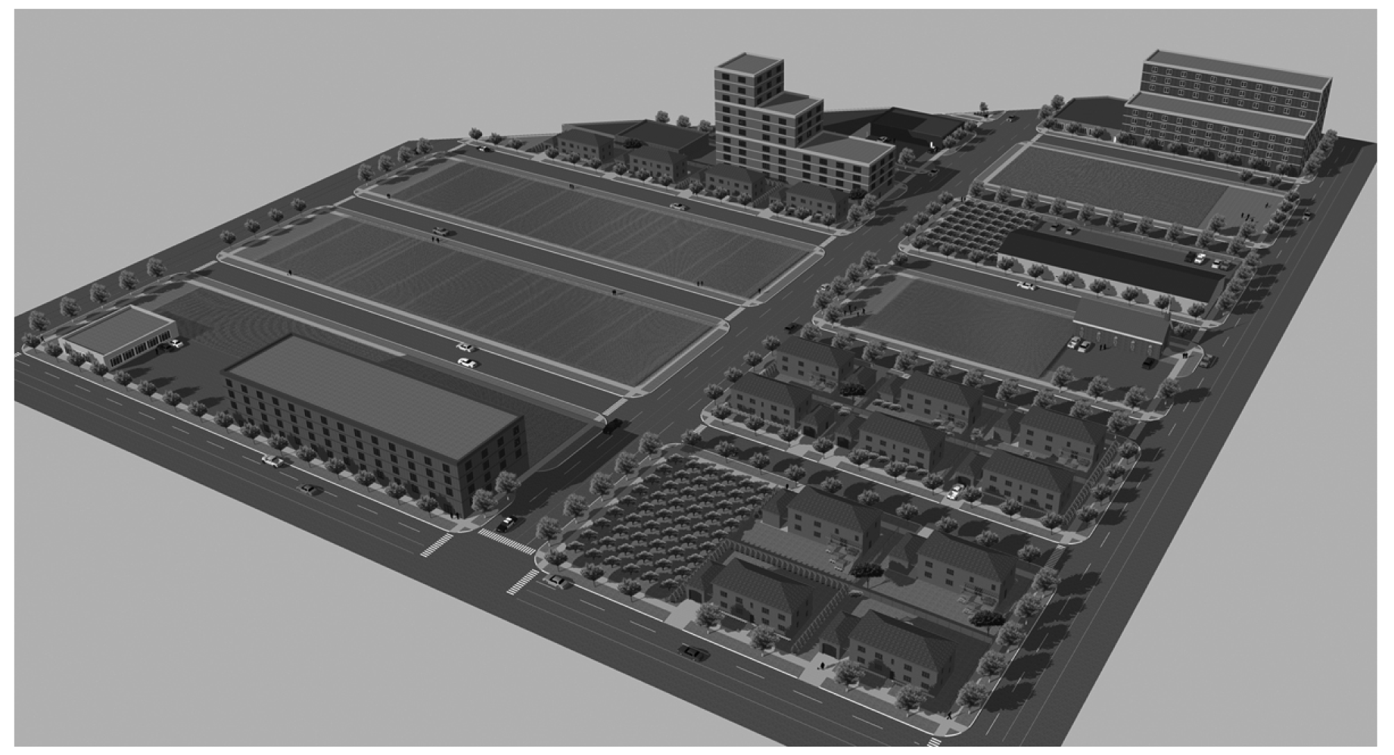
One of the ideas receiving much attention lately is the idea of a much less dense urban population, with urban farming [12], the retention of some retrofitted buildings, and the creation of some new structures (Figure 4). Many of the proposals are quite similar to ideas expressed by Frank Lloyd Wright in his “Broadacre City” proposal. The future of Detroit may be in experimentation to create the decentralized city.
2.3. Assessing Environmental Quality
Since the 1960s quantitative measures to assess environmental quality and lessons learned from these studies have greatly expanded. Two excellent primers on the subject include a review by Taylor, Zube, and Sell and a book by Smardon, Palmer, and Felleman [13,14]. Professionally, in the United States visual quality assessments methods are dominated by the synthetic, expert derived methodology attributed to Grant Jones in collaboration with others [15]. However, this approach relies upon assumptions based in artistic principles about visual quality that have been long refuted in the fine arts. Because this approach does not have science-based knowledge to support the method, the expert approach may be eventually discarded. For the most part, science based highly predictive models have been difficult to build. Models such as the one by Burley in 1997 typify the general predictive power of the best models, explaining about 67% of the variance [16]. In general these models suggest that respondents prefer environments with animals, plants, and geological features; most man-made features are not preferred. Numerous investigators have confirmed these findings and have provided general principles to follow when managing the landscape [17,18]. The implication is that buildings, cars, streets, and people comprise features that are not preferred. Research indicates that even a finely crafted and honored building such as a Frank Lloyd Wright building is less preferred than images from nature [19]. These findings do not sit well with people who build cities and the research has largely been ignored. In addition, researchers are finding that people evaluate the environment through a multiple factor lens and do not just consider aesthetics. They also consider economics, culture, ecology, as well as functions [19]. Again this may not be welcome news, especially by single use stakeholders such as environmentalists who do not wish to consider economic issues, or a single use highway transportation advocate who does not wish to consider cultural issues, or an architect who does not understand why people do not want to look at his or her wonderful building from their backyard. Nevertheless, some investigators remain focused upon improving their predictive models to assess the environment, working toward potential universal models that may be widely applied.
2.4. Study Intent
We were interested in building a new predictive, somewhat universal model with predictive power that explains over 70% of respondent variance, based upon respondents from France, Portugal, and North America. In addition we were very interested in applying the model to understand the predicted environmental quality of Frank Lloyd Wright's “Broadacre City” vision as compared with the past built structure of Detroit and with the new vision for Detroit. Our hypothesis is “the new proposals for Detroit and Frank Lloyd Wright's “Broadacre City” proposal will be significantly preferred over the past configuration of Detroit during its most prosperous years”.
3. Methodology
We followed the procedures and methodology described by Burley [16] where respondents are shown 10 pictures at a time and asked to sort them from most preferred to least preferred. For each respondent this is repeated 5 times (50 pictures total) [16]. Then a new respondent is shown a set of pictures. Once all the pictures have been shown (250), the images are sorted into a new order, so that each picture has an opportunity to be compared to another picture. The respondents were individuals from France, Portugal and North America. The images were a combination of pictures from the original study by Burley [16]. Regression analysis is employed to find the best model (an equation with the combination of significant variables p ≤ 0.05, explaining the maximum amount of variance, but not over-specified).
Providing that we could produce a predictive model we would then measure some photographic images from Detroit's past, drawings by Frank Lloyd Wright for his “Broadacre City”, and digital model images illustrating ideas for the new vision of Detroit to evaluate differences in the set. Low values indicate preferred environmental quality and high values indicate less preferred environments.
4. Results
Table 1 represents the best model derived from the study. It explains about 75.04% of the variance by the respondents. All of the predictors are significant and the overall equation has a p-value of less than 0.0001, which means that it is projected to make a false prediction once every 10,000 times. The results can be employed to measure the predicted environmental quality of an image (photographs, drawings, digital models) from a design. Scores ranging in the 100s indicate poor environmental quality. Scores near 40 indicate preferred environmental characteristics. For any given score, the 95% confidence interval is about plus and minus 4.8 points. For example a score of 90 means that the expected value for the image ranges between 85.2 and 94.8 (p ≤ 0.05). A score of 80 for another image would indicate that the image is interpreted as being perceptually different by the respondents than the image that scored 90.
5. Discussion and Conclusions
The regression results form an equation that can be employed to examine and assess the spatial quality of the environment. We examined photographs of Detroit prior to the economic collapse of the city, drawings by Frank Lloyd Wright of his “Broadacre City” and images of a Google Sketch-up model depicting ideas for the new vision for Detroit. The images from old Detroit scored in the range of 81 to 86. In other words, the perceived environmental quality of old Detroit was relatively poor. During the history of using these equations, only industrial sites, utility/infrastructure settings, and highly eroded and abandoned landscapes scored worse [16].
The images of “Broadacre City” scored in the range of 50 to 55. These scores are often better than the assessed scores of many high quality urban landscapes. The scores are similar to many parkland settings and agricultural districts. Landscapes with an abundance of flowers, mountains, and wildlife score better than the “Broadacre City”.
The digital model of the new vision for Detroit scored in the ranges of 55 to 60. This means that respondents will consider the environment for the reinvented Detroit as significantly better than the condition of the prosperous Old Detroit. While the vision for the reinvented Detroit scored worse than the images from “Broadacre City”, the 95% confidence tails for the reinvented Detroit and for “Broadacre City” do overlap and respondents my not necessarily consider the new vision for Detroit any different than the “Broadacre City” proposal.
We interpret the results of this study to mean that the design for “Broadacre City” and the new vision for Detroit as better environments than the conditions of Detroit during its prosperous period; but the “Broadacre City” and the new vision for Detroit as not being significantly different.
While our statistical investigation has revealed that the “state-of-the-art” in assessing environmental quality has made advances in explaining a substantial portion of the variance of the respondents, it does not mean that these results are rigidly established. Too much can be read into accepting the predictors as fact. This is why some investigators choose instead to present broad general principles [17,18,20]. In addition, the respondents from other cultures may have different perceptions concerning the spatial composition of the landscape [5]. Nevertheless, the results are consistent with past studies that suggest respondents prefer biospheric (natural-like) environments and not highly urbanized (noospheric) environments [20]. For example, a Frank Lloyd Wright highly acclaimed bank building in southern Minnesota generates scores in the mid-80s, suggesting low preference by the respondents. Even Frank Lloyd Wright's Kaufmann house (a house next to a waterfall) scores poorly when the house is featured and only scores better when the landscape is featured and the house is in the background. We find that Robert Thayer's seminal work, Gray World, Green Heart: Technology, Nature, and Sustainable Landscape concerning ideas about grayfields and their potential transformation compatible with the visions of Frank Lloyd Wright and the new visions by contemporary designers and planners for reclaiming Detroit a good resource and starting point for individuals to consider the transformation of their local grayfields [21].
In our study we conclude that while Frank Lloyd Wright had a vision for creating low density living environments mixed with agriculture and preserved natural spaces, his vision has not been widely embraced. However his vision is consistent with the preferences of respondents for landscape. The new vision for Detroit may be a city where his general ideas become a reality.


| Variable | Estimate | Pr > F |
|---|---|---|
| Intercept | 58.98827 | <.0001 |
| V2 | 0.07725 | <.0001 |
| V10 | 0.03775 | <.0001 |
| CVQ | −1.18505 | <.0001 |
| V32 | −0.01074 | <.0001 |
| V52 | 0.01161 | 0.0002 |
| V1V2 | −0.00181 | 0.0002 |
| V1V5 | −0.00026 | 0.0041 |
| V1V10 | 0.00134 | 0.0277 |
| V2V14 | −0.00071 | 0.0009 |
| V5V9 | 0.00018 | 0.0080 |
| V7V18 | −0.00092 | 0.0065 |
| V8V14 | 0.00025 | 0.0145 |
| V8V15 | 0.00425 | 0.0004 |
| V15V18 | 0.00023 | 0.0272 |
| V2V32 | −0.00012 | 0.0135 |
| V6V34 | 6.13388E − 7 | 0.0369 |
| V8V34 | −7.83802E − 7 | 0.0423 |
| V11V52 | 0.00117 | 0.0012 |
Where:CVQ = environmental quality index [16]V1 = perimeter of immediate vegetationV2 = perimeter of intermediate non-vegetationV3 = perimeter of distant vegetationV4 = area of intermediate vegetationV5 = area of waterV6 = area of distant non-vegetationV7 = area of pavementV8 = area of buildingV9 = area of vehicleV10 = area of humansV11 = area of smokeV14 = area of wildflowers in foregroundV15 = area of utilitiesV16 = area of boatsV17 = area of dead foreground vegetationV19 = area of wildlifeV30 = open landscapes = V2 +V4 + (2 × (V3 +V6))V31 = closed landscapes = V2 +V4 + (2 × (V1 +V17))V32 = openness = V30 − V31V34 = mystery = V30 × V1 × V7/1140V52 = noosphericness = V7 + V8 + V9 + V15 + V16
Acknowledgments
We wish to thank Yuemin Jin for the use of her recent photograph of downtown Detroit.
References
- Loures, L. Planning and Design in Postindustrial Land Transformation: East Bank Arade River, Lagoa—Case Study; Ph.D. Dissertation; Faculdade de Ciencias e Technologia, Universdidade do Algarve: Faro, Portugal, 2010. [Google Scholar]
- Turner, T. City as Landscape: A Post-Postmodern View of Design and Planning; E & FN Spon: London, UK, 1996. [Google Scholar]
- Burley, J.; Wang, Y.; Loures, L. New ecologies: Emergence of the urban savanna and cliff detritus in a post post-modern era. In New Models for Innovative Management and Urban Dynamics; Panagopoulos, T., Ed.; Universidade do Algarve: Faro, Portugal, 2009; pp. 13–22. [Google Scholar]
- Aguar, C.E.; Aguar, B. Wrightscapes: Frank Lloyd Wright's Landscape Designs; McGraw-Hill: New York, NY, USA, 2002. [Google Scholar]
- Mo, F.; Burley, J.B. Visual and environmental quality perception and preference in the People's Republic of China. Advances In Urban Rehabilitation and Sustainability 3rd WSEAS International Conference on Urban Rehabilitation And Sustainability (URES '10), 3 November–5 November 2010; Panagopoulos, T., Noronha, T., Beltrao, J., Eds.; Universidade do Algarve: Faro, Portugal; pp. 99–103.
- Burley, J.B. The restored Bauhaus in Dessau, Germany. In International Practice Professional Practice Network March 2008 Newsletter; American Society of Landscape Architects: Washington DC, USA, 2008; pp. 15–16. [Google Scholar]
- Gleiniger, A.; Matzig, G.; Redecke, S. Paris: Contemporary Architecture; Prestel: Munich, Germany, 1997. [Google Scholar]
- Newton, N.T. Design on the Land; The Belknap Press: Cambridge, MA, USA, 1971. [Google Scholar]
- McHarg, I.L. Design with Nature; Doubleday/Natural History Press: New York, NY, USA, 1969. [Google Scholar]
- Laurie, M. An Introduction to Landscape Architecture, 2nd ed.; Elsevier: Amsterdam, The Netherlands, 1986. [Google Scholar]
- Rutz, M.E. Public Gardens of Michigan; Michigan State University Press: East Lansing, MI, USA, 2002. [Google Scholar]
- Jagenow, C. Urban agriculture: A growing trend. Sites 2011, 5(2), 2–6. [Google Scholar]
- Taylor, J.G.; Zube, E.H.; Sell, J.L. Landscape assessment and perception research methods. In Environmental and Behavioral Research; Van Nostrand Reinhold Company: New York, NY, USA, 1987; pp. 361–393. [Google Scholar]
- Smardon, R.C.; Palmer, J.E.; Felleman, J.P. Foundations For Visual Project Analysis; John Wiley and Sons: New York, NY, USA, 1986. [Google Scholar]
- Jones & Jones. In Visual Impact Assessment for Highway Projects; U.S. Department of Transportation, Federal Highway Administration, National Highway Institute and Office of Environmental Policy: Washington DC, USA, 1981.
- Burley, J.B. Visual and ecological environmental quality model for transportation planning and design. TRR: J. Transp. Res. Board 1997, 1549, 54–60. [Google Scholar]
- Kaplan, R.; Kaplan, S. The Experience of Nature: A Psychological Perspective; Cambridge University Press: Cambridge, UK, 1989. [Google Scholar]
- Kaplan, R.; Kaplan, S.; Ryan, R. With People in Mind: Design and Management of Everyday Nature; Island Press: Washington, DC, USA, 1998. [Google Scholar]
- Mo, F.; LeCleach, G.; Sales, M.; Deyong, G.; Burley, J.B. Visual and environmental quality perception and preference in the People's Republic of China, France, and Portugal. Int. J. Energ. Environ. 2011, 4(5), 549–557. [Google Scholar]
- Burley, J.B. The science of design: Green vegetation and flowering plants do make a difference: Quantifying visual quality. The Michigan Landscape 2006, 49(8), 27–30. [Google Scholar]
- Thayer, R. Gray World, Green Heart: Technology, Nature and Landscape Sustainability; John Wiley & Sons: New York, NY, USA, 1994. [Google Scholar]
© 2011 by the authors; licensee MDPI, Basel, Switzerland. This article is an open access article distributed under the terms and conditions of the Creative Commons Attribution license (http://creativecommons.org/licenses/by/3.0/)
Share and Cite
Burley, J.; Deyoung, G.; Partin, S.; Rokos, J. Reinventing Detroit: Reclaiming Grayfields—New Metrics in Evaluating Urban Environments. Challenges 2011, 2, 45-54. https://doi.org/10.3390/challe2040045
Burley J, Deyoung G, Partin S, Rokos J. Reinventing Detroit: Reclaiming Grayfields—New Metrics in Evaluating Urban Environments. Challenges. 2011; 2(4):45-54. https://doi.org/10.3390/challe2040045
Chicago/Turabian StyleBurley, Jon, Gina Deyoung, Shawn Partin, and Jason Rokos. 2011. "Reinventing Detroit: Reclaiming Grayfields—New Metrics in Evaluating Urban Environments" Challenges 2, no. 4: 45-54. https://doi.org/10.3390/challe2040045
APA StyleBurley, J., Deyoung, G., Partin, S., & Rokos, J. (2011). Reinventing Detroit: Reclaiming Grayfields—New Metrics in Evaluating Urban Environments. Challenges, 2(4), 45-54. https://doi.org/10.3390/challe2040045