Rock Art of Soqotra, Yemen: A Forgotten Heritage Revisited


Excellence Cluster TOPOI, Freie Universität, 14195 Berlin, Germany
Arts 2018, 7(4), 99; https://doi.org/10.3390/arts7040099
Submission received: 27 September 2018
/
Revised: 25 November 2018
/
Accepted: 28 November 2018
/
Published: 3 December 2018
(This article belongs to the Collection World Rock Art)
Abstract
:This paper presents a comprehensive review of historical and current rock art research on the island of Soqotra, Yemen and places these sites within a spatial framework from which it analyses themes concerning water and the visibility and invisibility of these sites within the broader landscape. The analysis of these sites shows how water was of fundamental importance to the indigenous inhabitants over the longue durée. It also highlights how rock art has not only been able to reinforce the ethnographic and historical accounts of the indigenous inhabitants, but also strengthen our temporal knowledge of the social and cultural lives of the inhabitants of Soqotra.
1. Introduction
In 1996, the rock art researcher Michael Jung undertook a literary review of all the rock art sites on Soqotra (Jung 1996). Within this work, five open-air petroglyph sites and one cave containing pictograms were identified. While recognising that rock art on the island had probably been neglected during the numerous archaeological expeditions to the island, Jung suggested that the paucity of rock art sites on Soqotra was to be attributed to the fact that rock art had little importance for the inhabitants (Jung 1996, p. 79). With recent fieldwork undertaken by the author, however, this situation is changing and not only is the richness of Soqotra’s rock art tradition being recognised, but new rock art sites are being discovered and others for which few records existed are being comprehensively recorded (Strauch 2012; Jansen van Rensburg and De Geest 2015; Jansen van Rensburg 2016a, 2018; Jansen van Rensburg et al. 2018). The aims of this paper are twofold: firstly, to revisit Soqotra’s rock art heritage and catalogue the sites and motifs from historical and current studies. Secondly, to analyse the spatial relationship of the sites from natural and cultural perspective. This comprehensive record and analysis of the sites and their motifs provides an important step forward in enriching rock art studies on Soqotra.
2. Background
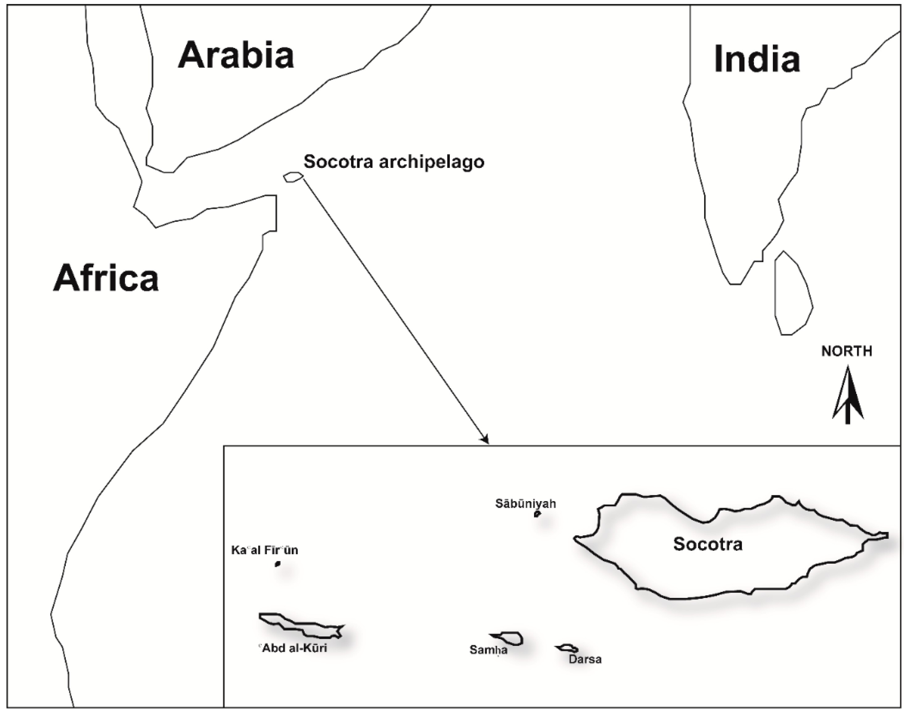
The Soqotra Archipelago lies approximately 250 km northeast of Cape Guardafui, Somalia and 380 km south of Rās Fartaq, Yemen. The archipelago is made up of four main islands, Soqotra, ‘Abd al-Kūri, Samha and Darsa, and two rocky outcrops Sābūniyah and Ka‘al Fīr‘ūn. The main island of Soqotra is c. 135 km in length, c. 42 km in width and has a surface area of c. 3650 sq. km making it one of the largest of the Arabian islands (Edgell 2006, p. 423). Geologically, the island of Soqotra is composed of Precambrian basement rocks that are overlain unconformably by Cretaceous and Tertiary limestones that range from between 300 m and 900 m in elevation and cover almost half of the island’s surface (Beydoun and Bichan 1970, p. 414). The older igneous and metamorphic basement rocks are particularly well exposed along the Ḥagher, a granite mountain range that stretches across the centre of the island west south-westerly to east north-easterly ridge and reaches up to c. 1500 m above sea level (Figure 1). The limestone plateau forms a rich karstic landscape that is composed of numerous natural rock cavities, or tafoni (sing. tafone), and several large cave systems (De Geest 2006, pp. 7–8). The tafoni openings have and continue to be used by the inhabitants for storage, living quarters, animal shelters, and in some cases burials. The cave systems, however, are avoided as according to folkloric belief they are inhabited by enormous white snakes believed to be capable of killing a man (Morris 2002, p. 214).
Due to Soqotra’s unique geographical position and mountainous landscape, it is influenced by several large-scale weather phenomena, which include the seasonally reversing south-west and north-east monsoon winds. Unlike the low-lying neighbouring areas of Arabia and Africa, both these winds bring rain, although the majority of the rainfall occurs during the north-east monsoon. Average annual rainfall varies greatly between the coast and interior plains, which receive approximately 170 mm, and the mountains that receive approximately 1500 mm. Rainfall in the mountains generally occurs in the form of short convection thunderstorms that result in violent flash floods. The high precipitation in the mountains is also the result of dews, drizzle and fogs that, especially during the south-west monsoon, can contribute up to 357–567 mm of moisture (Scholte and De Geest 2010, p. 1507). This precipitation is especially important during the drier south-west season as it generates a slow but persistent surface runoff, which is often the only source of water in the Ḥagher and surrounding limestone plateaux (Rossini 2014, p. 29). While the precipitation regime appears to be stable, the reality is that they do fail. The failure of these rains and the ensuing drought often has dire consequences, such as in 1847 when a severe drought caused wide-spread famine and decimated livestock (Hunter and Sealey 1986, p. 113).
The north coast was, and remains, the most densely populated area on Soqotra with over twelve thousand people spread out between the three main villages of Ḥadiboh, Qalansiyah and Qādub. This can be attributed to the morphological nature of the Ḥagher, which influences the drainage of water in an almost entirely north north-easterly direction across the northern coastal plains. The two exceptions to this are the westerly flow of the wadis in the valleys of Qalansiyah and Shu’ub, and the southerly flow of a limited number of wadis along the southern Nōged coastal plain (Beydoun and Bichan 1970, p. 415). The southern coastal plain on Soqotra is made up of one continuous arid plain of c. 80 km in length that reaches approximately 6 km inland where it ends at the sheer cliffs of the limestone escarpment (Cheung et al. 2006, p. 31). Settlement along the south coast was up until the 20th century limited to a few fishing villages, although during the wetter months some transhumance was practiced by Bedouins living in the interior (Morris 2002, pp. 221–22).
Soqotra’s population is geographically and culturally divided into two groups of people, those who live in the mountains and those who live along the coastal plains. A geographical division that refers to those people who belong to kin-based tribal groups, own land, and have access to specific land and water resources; and those who have no tribal affiliation and are not land owning (Morris 2002, p. 223). The latter being mostly African and Arab settlers who live along the coast, and the former an array of different tribes that live in the mountainous interior and call themselves Bedouins.
The island of Soqotra has a rich historical record that is inextricably linked to both its strategic position at the entrance to the Red Sea and the islands abundant supplies of incense, aloes and Dragon’s Blood (Jansen van Rensburg 2016b, pp. 6–16). The earliest detailed historical account of the people residing on Soqotra was written by an anonymous Greek trader from Egypt in the mid-1st century AD in a book entitled the Periplus Maris Erythraei (Casson 1989, p. 69). According to the Periplus, Soqotra was under the rule of the ‘king of the frankincense-bearing land’ (Hadhramaut) and was being leased to Arabian merchants. Moreover, we learn these merchants together with other traders from ancient Greece and India resided on the island’s north coast (Casson 1989, pp. 169–70). During the medieval period, there are prolific references to Soqotra in the writings of Muslim, Chinese, and European geographers, navigators, and travellers. These accounts tend to be primarily concerned with the procurement of aloes, dragon’s blood and ambergris and the presence of a Christian population (Jansen van Rensburg 2016b). The earliest account concerning Christians is in the 6th century AD, when the Greek Nestorian Christian monk and merchant from Egypt, Cosmas Indicopleustes, refers to having met Greek Christians from Soqotra in Ethiopia (McCrindle 1896, p. 119). While the exact date for the Christianisation of Soqotra is uncertain, it evidently took place no earlier than the 4th century AD (Müller 2001, pp. 146–47). The presence of Christians on Soqotra attracts a lot of attention in Muslim and European accounts from the 6th to 17th centuries AD (Biedermann 2006). Within these accounts, however, there are a number of authors who also mention that the Soqotri, notably those believed to be the indigenous inhabitants, were engaged in various forms of witchcraft; could change their shape at will and raise storms that would either bring ships back to the shore or conceal the island from raiders (Yule and Cordier 1993, p. 407; Smith 2008, p. 264). The inhabitants were, up until the 20th century, also known to have practised selenolatry and litholatry and there remained a strong belief in witches who were often tried and either killed or banished from the island (Snell 1955; Botting 1958, p. 204; Boxhall 1966, p. 218; Naumkin 1993, pp. 315–23).
The archaeological exploration of Soqotra has, since its beginnings in the mid-19th century, been primarily concerned with locating remains of the pre-Islamic occupation of Soqotra, particularly those which would support the rich historical evidence of this period. These expeditions have located stone tools believed to date to the Neolithic and Oldowan period (Naumkin and Sedov 1993, p. 537; Amirkhanov et al. 2009, pp. 68–74); a pre-Islamic settlement dated to the c. 1st to c. 4th centuries AD (Naumkin and Sedov 1993, p. 605), and several structures, settlements and graves believed to date between the c. 6th to c. 17th centuries AD (Bent 1900; Shinnie 1960; Doe 1992; Naumkin 1993; Weeks et al. 2002).
3. Rock Art
Despite over two centuries of intermittent exploration and archaeological surveys rock art remains one of the most neglected areas of study on Soqotra. Indeed, the earliest documented rock art sites that were recorded by Bent (1900) and Doe (1970, 1992) are some of the only records we have. This situation is exacerbated by the lack of location data that has hindered attempts by the author to relocate these rock art sites. This situation has only recently begun to change with fieldwork undertaken by the author, which has relocated and recorded both old and new rock art sites throughout the island. What follows is a catalogue of rock art sites, their location (where known), description, and a brief synopsis of the motifs found (Figure 2).
3.1. Cave Rock Art Sites
The beginnings of speleological explorations on Soqotra arguably began in the 1940s, although the first comprehensive explorations were undertaken by a Belgian Speleological Mission (The Soqotra Karst Project 2000–2008), led by Peter De Geest. These missions explored 50 caves and mapped over 32 km of underground galleries throughout the island (De Geest 2006). During these speleological explorations two caves containing only pictograms were discovered.
3.1.1. Cave-Drawings in the West
The first cave art site on Soqotra was found sometime during the Second World War, when British forces were stationed on Soqotra. The only evidence for this, however, comes from a report by Douglas Botting, an explorer who visited the island in 1956. Within his report he stated that he was unable to visit the western end of the island were cave-drawings had been found during the last war (Botting 1958, p. 206). Despite extensive speleological explorations and research, the location of this cave remains an enigma.
3.1.2. Hoq Cave
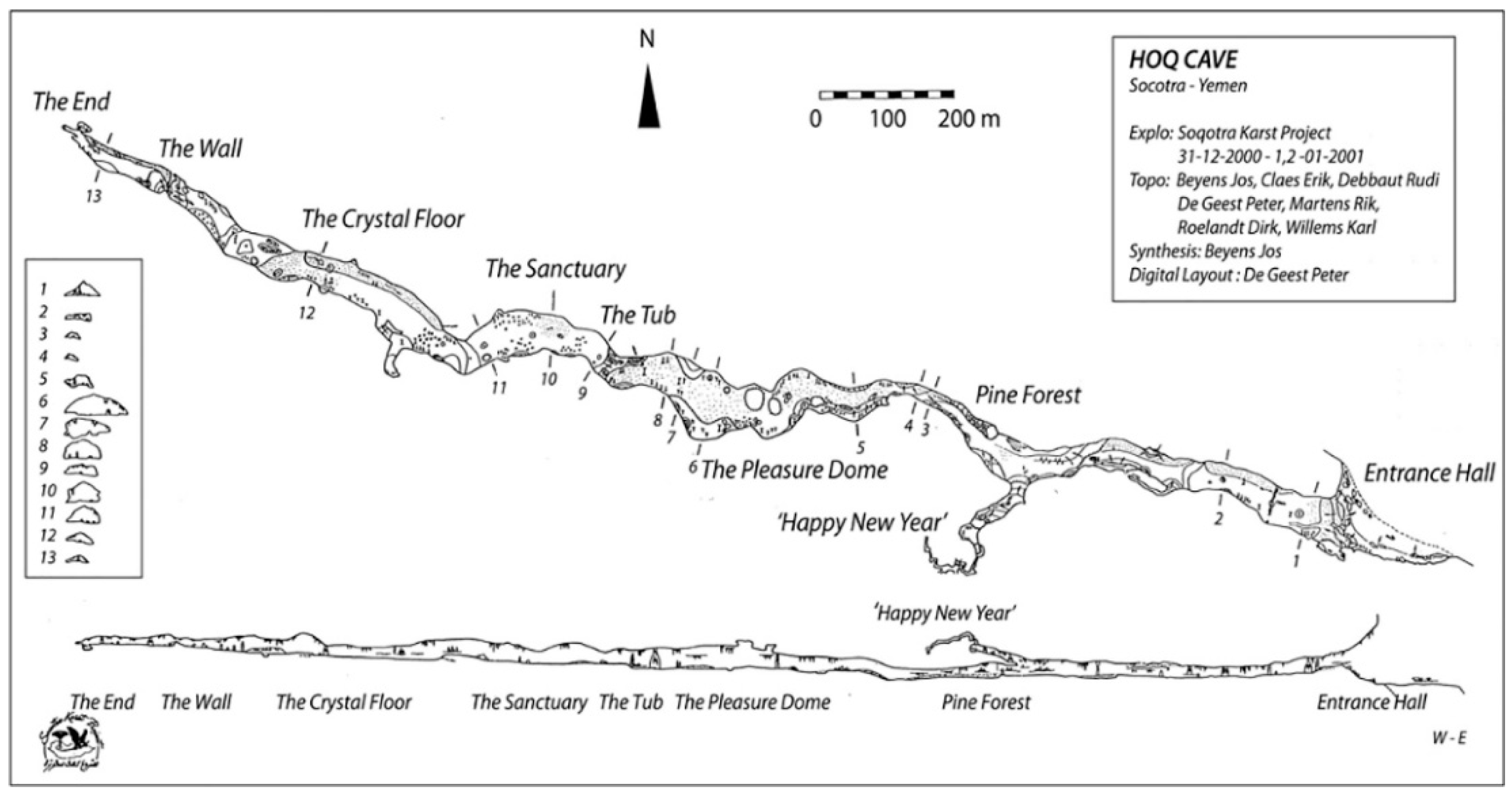
The discovery of Hoq cave was made during the first speleological mission undertaken by the Soqotra Karst Project (SKP) in 2000. The cave is situated in a limestone plateau on the north-east coast of Soqotra. The entrance to the cave lies midway up the side of the karst plateau and is clearly visible from the shoreline when arriving from a north-east direction. Access to the cave is possible by walking up a steep path towards a flat plateau situated 50 m below the entrance where the village Hoq had been located. This village was abandoned several centuries earlier when the freshwater resources found at the entrance to the cave dried out. The cave consists of a huge main gallery, up to 100 m wide and 30 m high, and stretches c. 2.5 km from the entrance to the end in an east south-east, west north-west direction (Figure 3). Approximately 200 m from the entrance one reaches the limite d’éclairement (Rouzaud 1997, p. 259), or the point at which it is necessary to have some form of artificial light. The first evidence for rock art is found approximately 1 km from the entrance and continues in what has been described as a processional path through to the end of the cave (Strauch 2012, p. 29). The findings within Hoq cave include a range of pictograms of Indian, South Arabian, Ethiopian, Greek and Bactrian inscriptions and images dated to from the 1st century BC to the 6th century AD (Figure 4). In addition, several incense burners, shells, torches, pottery fragments, and a wooden tablet inscribed in Palmyrene were found (Strauch 2012). This corpus of finds remains one of the richest sources of evidence for seafarers visiting Soqotra and the island’s involvement in the Indian Ocean trade networks (Dridi 2002; Dridi and Gorea 2003; Strauch 2012). Due to the various ship motifs, incense burners, and auspicious symbology found within the cave found it is considered to have been a mariner’s religious sanctuary (Dridi 2002, p. 589). Evidence for the ancient indigenous inhabitants of Soqotra, however, was noticeably lacking.
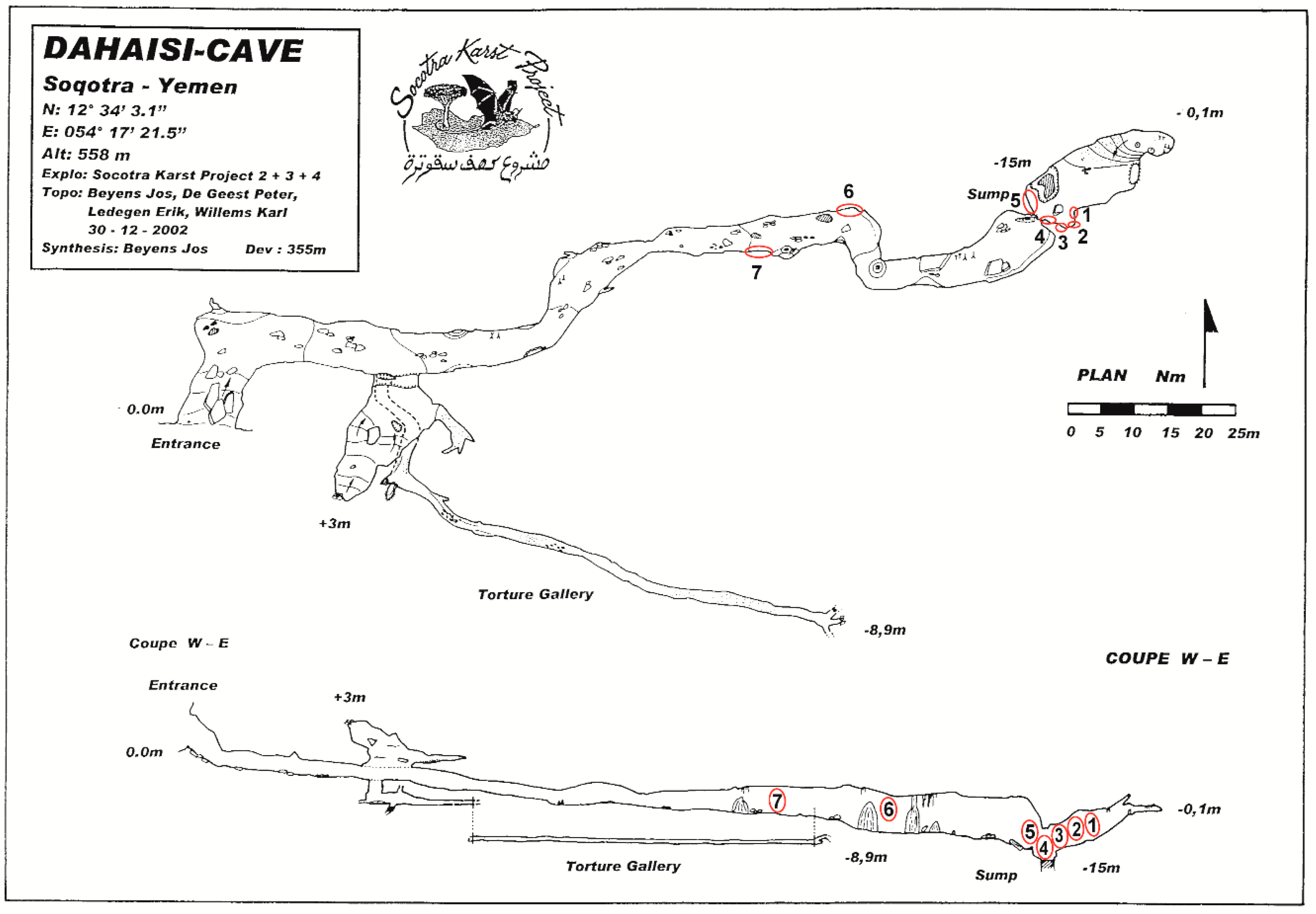
3.1.3. Dahaisi Cave
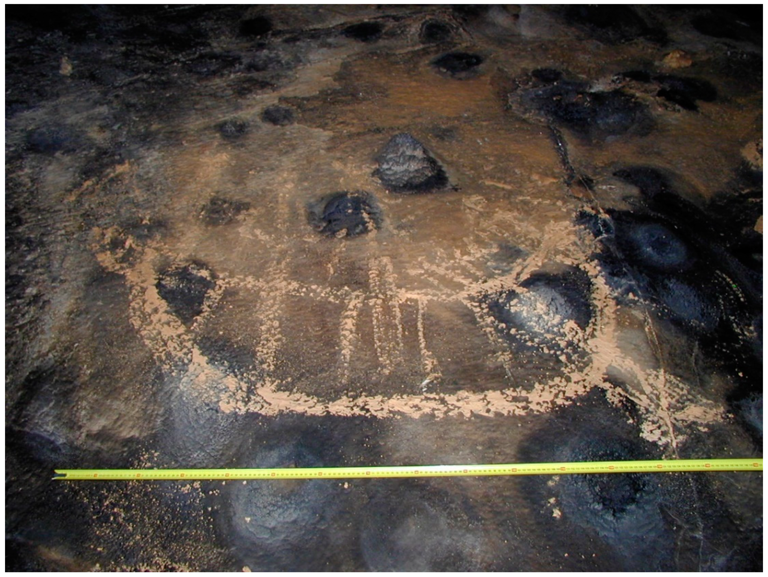
Dahaisi cave is located in the eastern interior of Soqotra on the Mōmi plateau at the base of a limestone outcrop on the north-eastern edge of a shallow valley. The entrance to Dahaisi cave is 5 m high and 10 m wide, yet it is only visible when approached from a southerly direction, and then only at a distance of approximately 100 m. Entry into the cave involves clambering down a series of large rocks and relict speleothems that appear to be related to the collapse of what was an earlier, probably larger, entrance (Jansen van Rensburg and De Geest 2015). The main gallery is approximately 2 m high and 5 m wide and branches right almost immediately after entering, and one need only travel 25 m before reaching the limite d’éclairement. At this point a narrow side gallery branches off to the south, while the main gallery extends down a gentle slope in a south-west, north-east direction (Figure 5). A well-worn pathway is clearly visible along the floor of the cave and in several areas, speleothems have been anthropogenically modified to provide easier access (Jansen van Rensburg 2018). The first pictograms are located 70 m from the entrance and consist of several badly faded geometric patterns and cruciform shapes (Jansen van Rensburg 2018). The remaining pictograms are all located in the final chamber, within which a large water-filled sump extends in a north-easterly direction under the floor of the cave. The pictograms are spread over five panels in the southern half of the chamber and appears to surround the water-filled sump. The largest panel lies directly above the sump and is replete with a variety of motifs that include geometric patterns, a variety of cruciform shapes and an Arabic shahada inscription. The other panels have very similar geometric patterns and cruciform shapes, yet they include what have been interpreted as ships, therianthropic and zoomorphic figures, an animal with rider, and additional Arabic inscriptions (Figure 6). Whilst no absolute dates for the rock art were obtained, the author was able to identify four phases that could be attributed to between the c. 1st century BC to the c. 15th century AD (Jansen van Rensburg 2018). The profusion of motifs over such a long time span, and that they surround the water-filled sump in the end chamber, suggests that the Dahaisi cave must have functioned as an important nodal point within the landscape that was related to the presence of water within the cave.
3.2. Open-Air Petroglyph Sites
Sites containing petroglyphs were amongst the first archaeological remains found during the mid-19th century expeditions to Soqotra (Wellsted 1835). However, it was not until the 20th century expeditions that the majority of these sites on Soqotra were recorded.
3.2.1. Eriosh
Eriosh is located on Soqotra’s north coast approximately 20 km south-west of the capital Ḥadiboh and 500 m south of the village Almāh. The site consists of a flat subhorizontal reefal limestone plain measuring approximately 10,000 m2 (1 ha). After the rains of the monsoon period, most of the site is covered by water, which is used locally to water livestock. Petroglyphs can be found across the entire site, although they are densest towards the central part of the site, which was reported to have had a roughly built wall built along its northern extent (Doe 1970, p. 5; 1992, p. 55). The site was first recorded by Lieutenant Wellsted in 1834, who remarked on the presence of inscriptions he believed to be Ethiopic, figures of men and camels, feet, crosses and ‘figures having a snake’s head’ (Wellsted 1835, p. 196). A subsequent visit by Hunter (1878, p. 371), mentions that he was unable to locate the inscriptions, but did record numerous hieroglyphs that were spread across the site. In addition, he mentions that the most numerous petroglyphs found at this site were the outlines of feet, mostly in pairs (Hunter 1878, p. 371). The inscriptions continue to attract attention and during an expedition to Soqotra in 1881 the naturalist George Schweinfurth visited Eriosh and described seeing hieroglyphs as well as letters from the Greek and Roman script. He also comments on finding several crosses, circles and figures having a snake’s head (Schweinfurth 1891, p. 52). Several years later the archaeologist Theodore Bent documented what he deemed to be a ‘purely Ethiopic script’ similar to that he had seen in Aksum (Bent 1900, p. 354). Amongst the script he also recorded seeing images of camels, snakes, numerous feet drawn side by side, and crosses. Some of the crosses were said to have been drawn between the feet, while others were drawn within a circle that were believed to be similar to those found on Ethiopic coins (Bent 1900, p. 354). In 1956, as part of an Oxford expedition to Soqotra, the archaeologist Shinnie visited the site and recorded several motifs, remarking that many of them were camel brands, possible inscriptions and feet (Shinnie 1960, p. 107). He also provides one of the first published drawn record of motifs from the site, much of which he had copied from drawings that were done during the earlier visits of Hunter and Schweinfurth, but never published (Shinnie 1960, p. 109, Figure 7). These drawings depict a number of cruciform shapes, feet and outlines of feet, a camel, inscriptions, and a number of indeterminable geometric patterns. Shortly after Shinnie, Eriosh was visited by Captain Peter Boxhall who mentions that in addition to the inscriptions, feet, camels and crosses found there were also portrayals of hands, goats and ‘symbolic plants’ (Boxhall 1966, p. 220). In 1967, the archaeologist Brian Doe also sought out Eriosh, remarking that the inscriptions he observed bore resemblance to early South Arabian inscriptions on the mainland with Ethiopic characteristics (Doe 1970, p. 5). He mentions that amongst the motifs there are numerous depictions of outlines of feet, geometric shapes, animals and anthropomorphs (Doe 1992, p. 57). In addition, Doe drew 40 motifs from the site, remarking that it had not been possible to take photographs due to the lack of a shadow cast by the shallowness of the pecking (Doe 1970, pp. 31–33, Figures 8–10; 1992, p. 43, Figure 4; p. 54, Figure 12; p. 56, Figure 13). The drawings depict the inscriptions, feet and outlines of feet, cruciform shapes, crosses within circles and squares, anthropomorphs (described by Jung (1996, p. 80) as orants), several indeterminable geometric patterns, and what has been described by Jung (1996, p. 80) as ibex, sheep, or oxen, and Boxhall (1966, p. 220) as goats (Figure 7). During the 1980s a joint Soviet-Yemeni study of the island and its inhabitants was undertaken by Vitaly Naumkin, who remarked that at Eriosh there were depictions of feet, a camel being hunted and inscriptions that did not resemble an early South Arabian script as was proposed by Doe (1992, p. 57). In addition to these descriptions he also recorded 23 motifs that included inscriptions, feet, a cruciform within a circle, camels, and various indeterminable geometric patterns (Naumkin 1993, p. 97, Figures 4 and 5a,b; 2012, p. 136, Figure 12). In conclusion, Naumkin (1993, p. 93) proposed dating the motifs at Eriosh to the second half of the first millennium BC, based on data obtained from a cemetery excavated in Raquf, in the north-eastern interior of the island. However, no explanation concerning the reasoning behind this hypothesis is given. Moreover, the dating of the cemetery has also been disputed (Weeks et al. 2002, p. 120). Despite these various reports and drawings made, the site of Eriosh has never been fully recorded and it is not clear as to the exact number of motifs that are present. This situation was exacerbated by roadworks that in 2003 cut a c. 10 m wide swath through the eastern part of the site destroying up to 10% of the motifs (Van Damme et al. 2004).
3.2.2. SHP_067
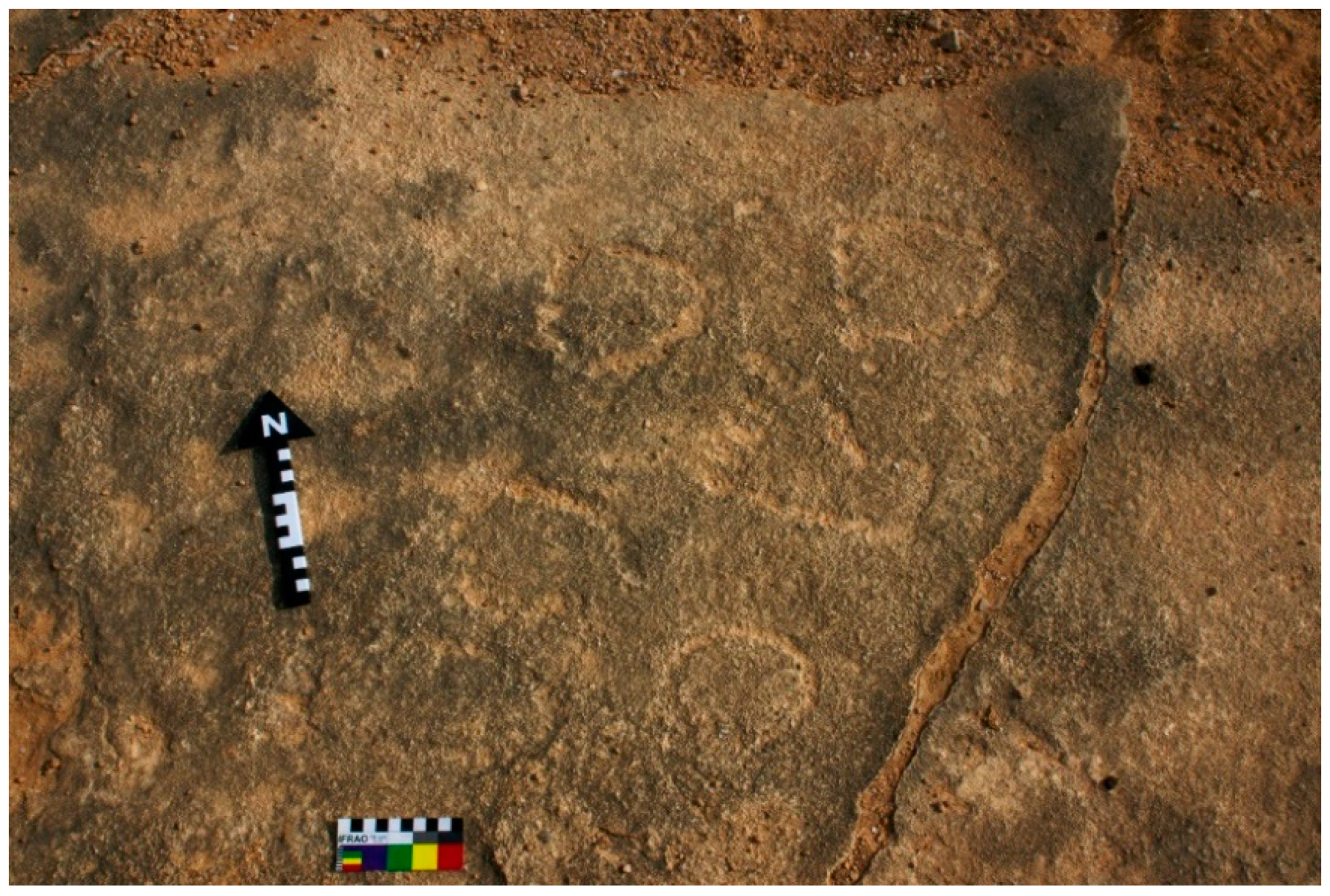
SHP_067 lies on the north-eastern edge of the Ḥadiboh plain, c. 350 m south-west of the modern town of Suq and c. 2.5 km west of the capital, Ḥadiboh. The site is composed of an outcropping of several flat plates of Calcarenite limestone that extends 176 m in an east-west direction and are interspersed with aeolian and alluvial sands, gravel, and scrub. Petroglyphs can be found throughout the entire outcrop, although the main concentration lies c. 103 m west of the eastern-most edge of the outcrop in an area spanning approximately 11 m × 5 m. The first documented evidence of this site was by Boxhall (1966, p. 20) who, other than mentioning having found the site, provided no description of the motifs. Shortly thereafter, the site was visited by Doe (1961, 1992) who recorded a ‘number of pecked designs’, that included cruciform shapes, a foot, and motifs that were ‘fanciful and flowerlike’ in design (Doe 1992, p. 82). According to Doe, some of the motifs were made by the Portuguese during their short-lived occupation of Soqotra, while others, particularly some of the cruciform shapes were pecked during the early foundation of Christianity on Soqotra (Doe 1992, p. 82). He attributes this early date to the similarities between the cruciform shapes found at SHP_067 and those found in the vicinity of a sixth century AD text recorded at Ḥuṣn al-Ghurāb, present-day Bi’r ‘Alī in the Southern Ḥaḍramawt (Doe 1961). Doe’s description and his sketches of ten motifs (see Doe 1970, pp. 84–85, Figures 29 and 30; 1992, pp. 82–83, Figures 19 and 20) were, up until recently, the sole record of this site. Further work undertaken by the author in conjunction with the Soqotra Heritage Project in 2018, has expanded upon this corpus, locating and recording 187 rock art motifs that include feet, cupules, a ship, various geometric patterns, cruciform shapes, several plant-like motifs, and a script (Jansen van Rensburg et al. 2018) (Figure 8). The script found at SHP_067 is similar to the inscriptions recorded in Eriosh (Doe 1970, pp. 84–85, Figures 29 and 30; 1992, pp. 82–83, Figures 19 and 20), both of which have recently been identified as being the same or closely related to a script recorded in Dhofar, known as Script 1 (Alī Maḥāš al-Šaḥrī and King n.d., p. 2). Whilst this script is known to be related to the family of South Semitic scripts it has not yet been dated or deciphered. The initial dating of the site by Doe suggests a 6th century AD terminus post quem. However, in light of the recent historical evidence for the conversion of the population at a much earlier period than had previously been considered (Bukharin 2012, pp. 522–26), it is possible to extend the terminus post quem to at least the 4th century AD. Unfortunately, this site lies in one of the most populated areas on Soqotra, and large swaths of the site are already divided into plots for housing.
3.2.3. Di Ṣeberho
The site of Di Ṣeberho lies at the western extremity of the southern coastal plain, c. 1 km west of the village of Di Ṣeberho. The site, located in 2015, is the first recorded instance of rock art in the south coast of Soqotra (Jansen van Rensburg 2016a). The petroglyphs recorded were all pecked onto a flat, quaternary limestone outcrop that has been exposed along a well-worn track that runs east to west from Di Ṣeberho to Ras Qaṭanan, and is still used by local herders. The actual size of the site is as yet unclear, as large areas remain covered by aeolian and alluvial sands and scrub. The petroglyphs that were recorded include various foot motifs, orants, cupules, a three-leaf clover-shaped motif and geometric patterns that have been interpreted as wasum, or signs that are used to indicate tribal identity, affiliation or ownership (Jansen van Rensburg 2016a, p. 150) (Figure 9). The site is believed to have functioned as a religious site and/or milestone along a ritualistic pathway. Due to the lack of cross symbology found at this site it is further supposed that the inhabitants had either not adopted Christianity, or that this site had been abandoned before the arrival of Christianity on the island in the 4th to 5th century AD (Jansen van Rensburg 2016a, p. 151).
3.2.4. Simar Qar
Simar Qar is located within a wide bay on the north-west coast, approximately 7 km south of Rās Bidoh and 11 km east of Rās Shu’ub. The petroglyphs are found on a large rectangular limestone block that appears to have formed part of the southern wall of a large abandoned settlement. The limestone block has two deep depressions cut into the front surface and what appear to be five abraded geometric motifs along the side (Figure 10). According to Doe, the limestone block was an ‘alter’ stone with two libation cupules and an abbreviated inscription or monogram in early South Arabian script. He also remarks that the inscription also bears similarities with a geometric pattern recorded by the Bents in Zimbabwe (Doe 1970, pp. 1–2, pl. 5–6; 1992, p. 46, pl. 26). When analysing the images of the limestone block it is clear that the two so-called libation holes are not only aligned, but are also cut to the same depth. This, together with the fact that they do not occur on the same face as the inscriptions would seem to indicate that they were probably post supports rather than libation holes.
3.2.5. Haidi, Qalansiyah
During the travels of Mabel and Theodore Bent they recorded a number of petroglyph sites, including one that was said to be near Haidi village ‘some distance in the direction of the mountains’ from Qalansiyah (Bent 1900, p. 351, Appendices VI). Despite several attempts, it has been impossible to relocate this site as there is no known village known as Haidi, and Qalansiyah has several mountains in its vicinity. According to the Bents, the site consisted of a large upright rock with inscriptions believed to be either late Himyaritic or Ethiopic (Bent 1900, p. 351). The inscriptions that were copied, however, appear to be the same or closely related to the scripts that were recorded in Eriosh and SHP_067, which have been identified as being similar or closely related to a Script 1 that was recorded in Dhofar (Alī Maḥāš al-Šaḥrī and King n.d., p. 2).
3.2.6. Dihaiterere
The site of Dihaiterere remains another enigmatic site that was recorded by the Bents during their travels around Soqotra. Within the appendices, there are eight cross designs that were said to have been copied from the rocks of Dihaiterere on the hill Ditrerre, a spur of Hamar (Bent 1900, p. 438). While this site is not directly mentioned in the text it is likely that the reference to ‘a rock at the top of a hill to the east of the island which had been covered with rude representations of the Ethiopic cross’ refers to this site (Bent 1900, p. 356). The name Dihaiterere is not known locally, although it is possible that it could refer to a hill in the vicinity of wadi Dirhor, known as Dihaher, which lies in the east (Bezděk et al. 2012, p. 39). This far, however, it has not been possible to relocate the site.
4. Discussion
Rock art is by its very nature part of the landscape insofar as it is a permanent inscription upon the land that creates a place from space. The signing of landscape and with it the act of place making is a practice that is widely known and has been in use for millennia. Nonetheless, it still provides a useful insight into the relationship between people and their natural surroundings, and how they included this into their social and ideological realms. To grasp even a rudimentary understanding of this space and the symbols therein one needs to see the landscape as a palimpsest that is multi-layered and continually changing both temporally, spatially and cognitively. Moreover, by going beyond the limits of seeing place as small, culturally significant locales within a specific temporal setting, one can also explore how visual signs were used within the overall natural and cultural environment of Soqotra. To achieve this, I analyze the above-mentioned sites and their motifs (see Table 1) in a social, cultural and environmental context in an attempt to gain an insight into the social, ideological, and cultural lives of the indigenous inhabitants’ of Soqotra.
4.1. Water
The location of rock art near sources of water is a recurring theme throughout the world (Bahn 2010, pp. 140–47). Whilst the reasons for this are varied and many hypotheses have been put forward one inalienable fact remains, water is necessary for human survival. This is especially true for Soqotra, which has a semi-arid climate with a highly variable precipitation regime that is influenced by its large geographical variation and two clearly distinct monsoon seasons, the drier south-west monsoon period (June to September) and the wetter north-east period (October to April). These factors play a significant role in the lives of the inhabitants as they are directly related to the presence and absence of water throughout the island. The importance of water for Soqotra’s inhabitants, especially during the drier south-west monsoon period is clearly reflected in the historical, archaeological and ethnographic record, which demonstrates not only the various management techniques employed in the preservation and use of water but also the devastating effects a drought can have on the population (Hunter and Sealey 1986, p. 113; Morris 2002; Jansen van Rensburg and Hopper 2017). Looking at the importance of water in relation to the rock art found throughout Soqotra two sites stand out, Eriosh and Dahaisi cave.
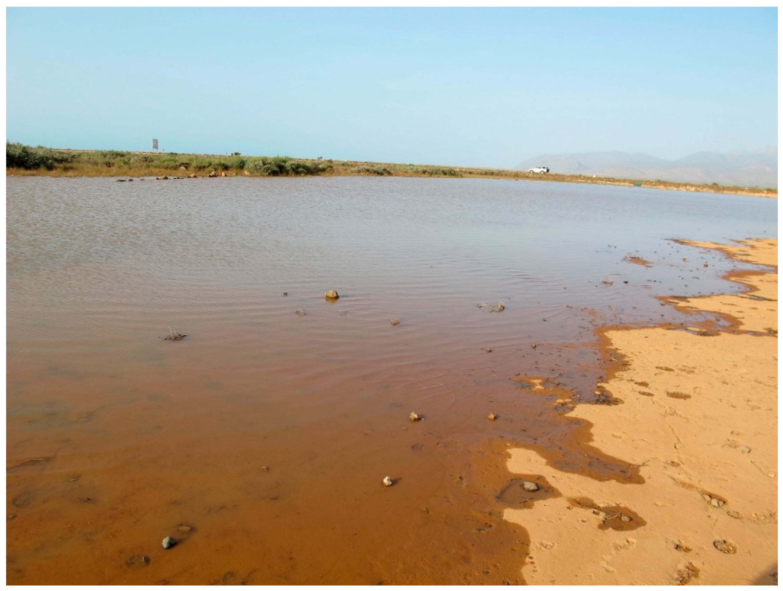
At Eriosh, the rock art occurs within a slight basin that especially during the rains of the monsoon period fills with water, submerging the petroglyphs (Figure 11). In the past it was reported that the northern extent of the site had been encompassed by a roughly built wall to hold the water in place so it does not spread out and dissipate (Doe 1970, p. 5; 1992, p. 55). Today the site is no longer walled, although it is still used by herders to water their livestock as it retains water for several weeks after the north-east monsoon rains. While the chronological sequence of the rock art at Eriosh is not clear, that it was likely to have been in use from arguably the second half of the first millennium would imply that it had some special significance. To understand what this significance may have been, it is necessary to look at how the symbology present interacts with the natural environment. To do this I look at what is purportedly the most common motif found at the site, the foot. Foot symbology occurs in many cultures throughout the world and much like the foot symbology found on Soqotra can occur by themselves and in conjunction with other symbols. This has given rise to a number of different interpretations relating to an associated with birth, death, fertility, places of power or/and sacredness (Achrati 2008; Hawkins 1987; Nayeem 1996; Jung 1993; Červiček 1986; Bahn 1998). Indeed, Jung (1993, p. 175) uses this point to argue that the cross symbology associated with the feet found at Eriosh suggests that this site was considered to be sacred during the Christian period on Soqotra. Whilst this interpretation would certainly fit with the historical record it is quite possible that the cruciform shapes may have been added later in an apotropaic manner, to reinforce what was already a sacred site. That this site may have been considered sacred lies in the fact that water has a direct correlation with birth, death and fertility, and that this site is the only large body of water with this area. Moreover, it is also likely that the annual submergence of the motifs held some form of special significance that was related to this site, probably as some form of ritual that was related to the monsoon rains and the life-giving water it would bring.
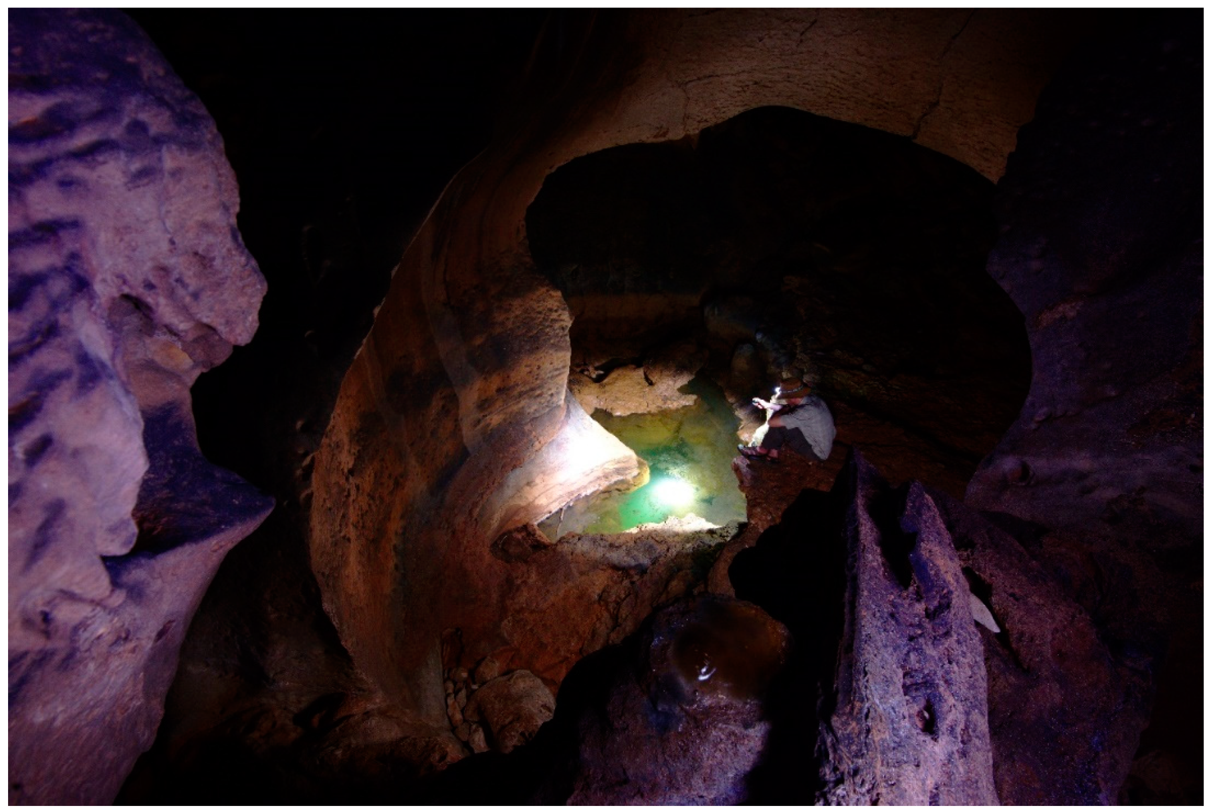
The second site is situated deep within the arid eastern interior of the island. Dahaisi cave is unique in that it is easily accessible and that within the final chamber there is a water-filled sump surrounded by pictograms (removed for peer review) (Figure 12). Whilst this cave, like others on Soqotra, is shunned by Soqotra’s indigenous inhabitants today it clearly held some importance in the past, whether as a general source of water for humans and/or livestock, or a place from which water would only be obtained in times of extremis. That it is likely to have been only used during times of extremis would seem the most likely scenario when considering the ethnographic evidence. However, this is contrary to the presence of rock art surrounding the water-filled sump in the final chamber, which spans a period from the 1st century BC to the 15th century AD. Whilst it is likely that over this long period of use Dahaisi would have been appropriated in different ways, the motifs surrounding the water-filled sump indicates that, much like at Eriosh, it was the presence of water, and its importance for the inhabitants that provided the motivation for the marking of this place.
Looking at the significance of other sites and their natural environment it is possible that some of the sites that have not yet been located may have a water source in their vicinity, and others may have had water in their vicinity sometime in the past. However, there remain those sites which are unlikely to have ever been directly associated with a water source. I would argue that in this case, some of the motifs could have been used as nodal points within the landscape. Points that could, amongst other functions, have been areas within which the motifs would have been indicators of nearby water sources. This is likely to have been the case at Di Ṣeberho, which lies in the western extremity of the arid southern coastal plain. The motifs at this site are predominately feet, the majority of which face in a westerly direction. It has been argued that these feet represent some form of ritualistic pathway, yet the purpose of this was not discussed (Jansen van Rensburg 2016a, pp. 149–50). When looking at the broader landscape, notably the hydrological conditions within this area, it becomes immediately apparent that to the west of this site there are a number of sources of water, that include non-perennial wadis, a spring and hand-dug wells. The spring and hand-dug wells, however, are virtually impossible to locate without local knowledge and their actual location is not readily shared with others outside of the community. Moreover, this is the only available source of water along the western half of the south coast (Othman 1996, p. 213). Consequently, it is likely that the rock art at Di Ṣeberho could have been an important waypoint within the landscape from which one could learn where water sources were, who had access to them and possibly even when water was available.
4.2. Visibility
The visibility and intervisibility of rock art sites are a major theme in rock art studies with technologies such as GIS being used to analyse the landscape through various algorithms (Wienhold and Robinson 2018). These tools provide archaeologists with new methods through which to statistically and spatially analyse rock art and its position in the landscape, and allow new insights to be obtained. However, in many cases, the research questions posed are modified or even driven by the available technology (Lock 2000; Tschan et al. 2000; Wheatley and Gillings 2000). Whilst the low number of rock art sites on Soqotra precluded a detailed analysis using GIS, it allowed their distribution to be plotted throughout the island. Once plotted it became abundantly clear that there was a clustering of rock art sites in the north, especially those near the coast. Whilst much could be read into this apparent distribution, the reality is that this is more to do with the focus of archaeological missions that have all but ignored the southern half of Soqotra (Weeks et al. 2002, p. 98). When looking at the sites on a micro-level, however, it was possible to see some patterns emerge. With the exception of Haidi, Qalansiyah and possibly Dihaiterere, for which little information is known, all of the petroglyph sites are found on flat slabs of rock within a flat plain that has few if any distinguishing marks, and are all but invisible until one almost walks over the site. This so-called invisibility is likely to have been the initial intention when the site was first marked. The location of the site being as important as the motifs that were displayed there. One could take this further and argue that these sites had various spatial meanings that were related to how one found the site, which in turn would influence how one would interpret the motifs therein. Therefore, the site could be experienced in different ways according to whether it is found in a chance encounter or was located with prior knowledge. This is not to say that these meanings remained static in a temporal sense, but rather that the meanings at various points in time could have been related to the difficulties, and ways in which one located the site. Di Ṣeberho is probably the clearest example of such a site, which is virtually impossible to find without prior knowledge (Figure 13). Moreover, not knowing what the various motifs represented one would not understand their meaning or be able to locate the available water sources to the west.
The site of SHP_067 also lies hidden within a flat plain with few visible landmarks within its vicinity, however, it also lies within a densely populated plain. What is interesting about this site is that the foot motifs, which are arguably earlier, are found spread out to the east and west, while the main cluster of motifs in the centre contain mostly cruciform shapes. This would appear to demonstrate that with the arrival of Christianity not only did the sites function potentially change, but also the area of the site that was considered to have importance. The presence of the cruciform shapes outside of the main central area are likely to have been, much like Eriosh, added in an apotropaic manner (Figure 14). When comparing these two sites it is clear that they both functioned as a place in space within the landscape, and the motifs therein were part of this process of creating this space. While Di Ṣeberho appears to have been used as a place from which one could learn the location of the water sources, at SHP_067 the creation of this space appears to have been related to the importance of the place within the landscape, especially during the Christian period. That this place may have been considered to have a sacred Christian function is interesting in that at Suq, approximately 500 m away, there was a church (Doe 1992, p. 88), which served the local congregation up until at least the 15th century (Foster 1967, p. 33). That this site had been chosen and marked with over 70 cruciform shapes, and that it was in such close proximity to a church could be related to the incorporation of what was initially a pagan site within a Christian ideology, which would certainly explain why many of the foot motifs have crosses pecked in their vicinity.
4.3. Indigenous Knowledge
The neglect of rock art studies on Soqotra has, up until recently, resulted in a much-skewed view of Soqotra and its inhabitants. In cataloguing and analysing the various rock art sites found throughout the island not only is it now possible to begin to better understand the breadth and richness of Soqotra’s rock art tradition, but also to glimpse elements of the indigenous inhabitants’ social, ideological, and cultural lives. Moreover, these rock art sites and the motifs therein are allowing for a better understanding of the often skewed view of the historical and ethnographic narrative by taking an indigenous point of view. Firstly, it appears that with the arrival of Christianity the cruciform shape became the most predominant symbol. However, it appears that the cross may have been placed besides the foot symbology not only in an apotropaic manner, but also as a form of syncretism. This syncretic behaviour is noted in both historically and ethnographic accounts, which remark that in spite of the inhabitants being Christian and revering the cross, they were also involved in a number of pagan rituals (Snell 1955; Yule and Cordier 1993, p. 407). It could also be argued that this was very much the case within Dahaisi cave, with its long sequence rock art that appears to demonstrate a change from earlier pagan symbology, to later Christian cruciform shapes and Arabic inscriptions. This long sequence also shows that, despite recent folkloric traditions to the contrary, the Soqotri were not only entering caves but spending time within them. That Hoq cave is purported to have had no indigenous involvement would, therefore, in light of the findings in Dahaisi, seem doubtful. Indeed, further surveys and a reappraisal of the motifs within Hoq cave are likely to provide deeper insights into the relationships between the visiting foreign sailors and merchants and the indigenous inhabitants. Finally, looking at the rock art in the context of the geographical differentiation of the indigenous inhabitants mentioned in the historical and ethnographic sources, there does not appear to be a clear cultural distinction in the style of the motifs. However, there is certainly a change in the types of motifs from arguably the Christian period. This can be seen when comparing the motifs at Di Ṣeberho in the south and SHP_067 and Eriosh in the north. In all these sites similar foot motifs, geometric patterns and orant figures are all present, yet Di Ṣeberho is the only site that has no cruciform shapes.
5. Conclusions
Revisiting the rock art heritage of Soqotra has demonstrated that, contrary to earlier reports, the indigenous people of Soqotra were actively engaged in the production of rock art for millennia. This long sequence, especially within Dahaisi cave, has shown that the aversion to entering caves as described in various ethnographic account is not a true reflection of the cultural beliefs of all the indigenous inhabitants of Soqotra. Cataloguing these sites has also helped in our understanding of the temporal, spatial, and cognitive factors that played a role in the location of sites. This has been especially apparent when looking at the presence of water. While it may not be clear as to whether water was meant to symbolise life, death or fertility that it held an important role in the lives of the indigenous inhabitants is clearly demonstrated throughout the island. At the north coast site of Eriosh as with the interior site of Dahaisi, the rock art is directly related to a source of water, while at the south coast site of Di Ṣeberho it is the presence of water in the vicinity that not only makes this site important, but helps us to better understand what meaning the motifs sought to convey. In addition to the presence of water, the location of the petroglyph sites within large featureless plains also indicates that their location was considered to have an importance that is likely to have been initially related to the difficulty of finding the site. Arguably, this meaning changed later when the site was re-located, as can be seen at SHP_067, where the Christian symbology appears to have supplanted the earlier pagan signs. The changing symbology seen in the long sequences of rock art provides further insights into the ethnographic and historical record, showing how the syncretism that was recorded is reflected in the rock art. Moreover, comparing the differences between different areas has begun to allow us to tease apart the geographical differentiation between different indigenous groups, showing also how ideological beliefs, such as Christianity, did not reach all parts of the island. Further findings and analysis of the relationships between sites, their motifs, and their position within the landscape will undoubtable provide more details from which it may be possible to further our understanding of the indigenous development of rock art of Soqotra, and ultimately Arabia. However, with the current lack of formal protection for cultural heritage sites on Soqotra and given that the World Heritage status of the island reflects natural heritage, many rock art sites may not survive long enough for future research to take place.
Funding
This research received no external funding.
Acknowledgments
I would like to thank Peter De Geest, Dan Britton, Dirk Van Dorpe and the Soqotra Heritage Project team for their help in the finding and recording of many of the rock art sites on Soqotra.
Conflicts of Interest
The author declares no conflict of interest.
References
- Achrati, Ahmed. 2008. Hand prints, Footprints and the imprints of evolution. Rock Art Research 25: 23–33. [Google Scholar]
- Alī Maḥāš al-Šaḥrī, Ali Ahmed, and Geraldine King. n.d. The Dhofar Epigraphic Project: A Description of the Inscriptions Recorded in 1991 and 1992. Unpublished.
- Amirkhanov, Kha A., Vladimir A. Zhukov, Vitaly V. Naumkin, and Alexander V. Sedov. 2009. Эпoха oлдoвана oткрыта на oстрoве Сoкoтра [Oldowan Age discovered at Socotra Island]. Pripoda 7: 68–74. [Google Scholar]
- Bahn, Paul. 1998. The Cambridge Illustrated History of Prehistoric Art. Cambridge: Cambridge University Press. [Google Scholar]
- Bahn, Paul. 2010. Prehistoric Rock Art Polemics and Progress. New York: Cambridge University Press. [Google Scholar]
- Bent, Theodore. 1900. Southern Arabia. London: Smith, Elder and Co. [Google Scholar]
- Beydoun, Ziad Rafiq, and Herbert Roy Bichan. 1970. The Geology of Socotra, Gulf of Aden. Quarterly Journal of the Geological Society of London 125: 413–46. [Google Scholar] [CrossRef]
- Bezděk, Jan, Vladimìr Hula, Luboš Purchart, and Kamil Král. 2012. List of local Socotran geographical names used in entomological literature. Acta Entomologica Musei Nationalis Pragae 52: 27–67. [Google Scholar]
- Biedermann, Zoltan. 2006. Soqotra Geschichte Einer Christlichen Insel im Indischen Ozean vom Altertum bis zur Frühen Neuzeit. (Maritime Asia 17). Wiesbaden: Harrassowitz. [Google Scholar]
- Botting, Douglas. 1958. The Oxford University Expedition to Socotra. The Geographical Journal 124: 200–7. [Google Scholar] [CrossRef]
- Boxhall, Peter G. 1966. Socotra—Island of bliss. The Geographical Journal 132: 213–22. [Google Scholar] [CrossRef]
- Bukharin, Mikhail D. 2012. The Greek inscriptions at Hoq. In Foreign Sailors on Socotra. The Inscriptions and Drawings from the Cave Hoq. Edited by Ingo Strauch. Bremen: Hempen Verlag, pp. 494–500. [Google Scholar]
- Casson, Lionel. 1989. The Periplus of the Erythraean Sea. Princeton: Princeton University Press. [Google Scholar]
- Červiček, Pavel. 1986. Rock Pictures of Upper Egypt and Nubia. Supplemento n. 46 agli Annali, Roma: Instituto Univesitatio Orientale, vol. 46. [Google Scholar]
- Cheung, Catherine, Lyndon Devantier, and Kay Van Damme. 2006. Socotra: A Natural History of the Islands and their People. Hong Kong: Odyssey. [Google Scholar]
- De Geest, Peter. 2006. Soqotra Karst Project (Yemen), 2000–2004. Berlin: Speläoclub. [Google Scholar]
- Doe, D. Brian. 1961. Ḥuṣn al-Ghurāb and the site of Qana’. Le Muséon 74: 191–98. [Google Scholar]
- Doe, D. Brian. 1970. Socotra: An Archaeological Reconnaissance in 1967. Miami: Coconut Grove, Field Research Projects. [Google Scholar]
- Doe, D. Brian. 1992. Socotra Island of Tranquillity. London: Immel. [Google Scholar]
- Dridi, Heidi. 2002. Indiens et Proche-Orientaux dans une grotte de Suqutra (Yémén). Journal Asiatique 290: 565–610. [Google Scholar] [CrossRef]
- Dridi, Hheidi, and Maria Gorea. 2003. Le voyage d’Abgar à Suqutra. Archéologia 396: 48–57. [Google Scholar]
- Edgell, H. Stewart. 2006. Arabian Deserts: Nature, Origin and Evolution. Dordrecht: Springer. [Google Scholar] [CrossRef]
- Foster, William. 1967. The Embassy of Sir Thomas Roe to India, 1615–1619. London: The Hakluyt Society. [Google Scholar]
- Hawkins, David F. 1987. Primitive rock carving in Qatar. Proceedings of the Seminar for Arabian Studies 17: 53–61. [Google Scholar]
- Hunter, Frederick M. 1878. Notes on Socotra. The Journal of the Anthropological Institute of Great Britain and Ireland 7: 364–72. [Google Scholar] [CrossRef]
- Hunter, Frederick M., and Charles W. H. Sealey. 1986. An Account of the Arab Tribes in the Vicinity of Aden. London: Darf Publishers. [Google Scholar]
- Jansen van Rensburg, Julian. 2016a. Rock art on Socotra, Yemen: The discovery of a petroglyph site on the island’s south coast. Arabian Archaeology and Epigraphy 27: 143–52. [Google Scholar] [CrossRef]
- Jansen van Rensburg, Julian. 2016b. The Maritime Traditions of the Fishermen of Soqotra, Yemen. Oxford: Archaeopress Archaeology. [Google Scholar]
- Jansen van Rensburg, Julian. 2018. The rock art of Dahaisi cave, Soqotra, Yemen. Rock Art Research 35: 180. [Google Scholar]
- Jansen van Rensburg, Julian, and Peter De Geest. 2015. Recording the rock art of Dahaisi cave, Socotra, Yemen. Proceedings of the Seminar for Arabian Studies 45: 1–14. [Google Scholar]
- Jansen van Rensburg, Jansen, and Kristen Hopper. 2017. Incense and imagery: Mapping agricultural and water management systems on the island of Socotra, Yemen. Proceedings of the Seminar for Arabian Studies 47: 129–38. [Google Scholar]
- Jansen van Rensburg, Julian, Ahmed Saeed Ahmed Al-Orqbi, and Esmail. Mohammed Ahmed Salem. 2018. Documenting a threatened rock art site on Soqotra, Yemen. Arabian Archaeology and Epigraphy 29: 198–203. [Google Scholar] [CrossRef]
- Jung, Michael. 1993. A map of southern Yemeni rock art with notes on some of the subjects depicted. Proceedings of the Seminar for Arabian Studies 24: 135–54. [Google Scholar]
- Jung, Michael. 1996. Rock art on Socotra Island/Yemen. Annali 56: 79–87. [Google Scholar]
- Lock, Gary. 2000. Beyond the Map: Archaeology and Spatial Technologies. Amsterdam: IOS Press. [Google Scholar]
- McCrindle, John W. 1896. The Christian Topography of Cosmas, an Egyptian Monk. London: The Hakluyt Society. [Google Scholar]
- Morris, Miranda. 2002. Manual of Traditional Land Use in the Soqotrian Archipelago, for G.E.F. (Global Environmental Facility). Project YEM/96/G32. Edinburgh: Royal Botanical Gardens. [Google Scholar]
- Müller, Walter W. 2001. Anitke und Mittelalterliche Quellen als Zeugnisse über Soqotra, eine einstmals Christliche Insel. Oriens Christianus 85: 139–61. [Google Scholar]
- Naumkin, Vitaly V. 1993. Island of the Phoenix: An Ethnographic Study of the People of SOCOTRA. Translated by V. A. Epstein. Reading: Ithaca. [Google Scholar]
- Naumkin, Vitaly V. 2012. The Archipelago of Socotra: Expeditions of 1974–2010. Moscow: Slavyanskiye Yazyki. [Google Scholar]
- Naumkin, Vitaly V., and Alexandra V. Sedov. 1993. Monuments of Socotra. Topoi 70: 569–623. [Google Scholar] [CrossRef]
- Nayeem, M. Abdul. 1996. The Sultanate of Oman. Hyderabad: Hyderabad Publishers. [Google Scholar]
- Othman, W. A. 1996. Hydrological Conditions of Socotra. In Proceedings of the First International Symposium on Socotra Island Present and Future, Aden, 24–28 March, 1996. Vol. 2, Natural Resources and Environmental Protection. Aden: University of Aden Printing and Publishing House, pp. 203–18. [Google Scholar]
- Rossini, Ludovico. 2014. Water management in a drought prone island. In Soqotra Archipelago (Yemen) Towards Systematic and Scientifically Objective Sustainability in Development and Conservation. Edited by Fabio Attorre. Rome: Edizioni Nuova Cultura, pp. 25–40. [Google Scholar]
- Rouzaud, Franҫois. 1997. La paléospéléologie ou: L’approche globale des documents anthropiques et paléontologiques conservés dans le karst profound. Quaternaire 8: 257–65. [Google Scholar] [CrossRef]
- Scholte, Paul, and Peter De Geest. 2010. The climate of Socotra Island (Yemen): A first-time assessment of the timing of the monsoon wind reversal and its influence on precipitation and vegetation patterns. Journal of Arid Environments 74: 1507–15. [Google Scholar] [CrossRef]
- Schweinfurth, Georg. 1891. Erinnerungen von einer fahrt nach Sokotra. Westermanns Illustrierte Deutsche Monatshefte 35: 29–53. [Google Scholar]
- Shinnie, Peter L. 1960. Socotra. Antiquity 34: 100–10. [Google Scholar] [CrossRef]
- Smith, G. Rex. 2008. A Traveller in Thirteenth-Century Arabia, Ibn al-Mujāwir’s Tārīkh al-Mustabir. London: The Hakluyt Society. [Google Scholar]
- Snell, Ian E. 1955. Witch Trials on Soqotra. Typescript; pp 7. Mukulla, Aden Protectorate; The Residency. Coral Gables, Florida: Miscellanea Asiatica Orientalis Series. American Documentation Institute Microfilm (ADIM) No. 5624. Washington, D.C.: Library of Congress. [Google Scholar]
- Strauch, Ingo. 2012. Foreign Sailors on Socotra: The Inscriptions and Drawings from the Cave Hoq. Bremen: Hempen Verlag. [Google Scholar]
- Tschan, Andre P., Wlodizimierz Raczkowski, and Malgorzata Lata lowa. 2000. Perception and viewsheds: Are they mutually inclusive? In Beyond the Map: Archaeology and Spatial Technologies. Edited by Gary Lock. Amsterdam: IOS Press, pp. 28–48. [Google Scholar]
- Van Damme, Kay, Peter De Geest, and Julian Jansen van Rensburg. 2004. Socotra Island: Conservation Issues. Available online: www.academia.edu/586488/Socotra_Island_Conservation_Issues (accessed on 23 September 2018).
- Weeks, Lloyd, Miranda Morris, Bernadette McCall, and Khalil Al-Zubairy. 2002. A recent archaeological survey on Soqotra. Report on the preliminary expedition season, January 5th–February 2nd 2001. Arabian Archaeology and Epigraphy 13: 95–125. [Google Scholar] [CrossRef]
- Wellsted, James Raymond. 1835. Memoir on the Island of Socotra. Journal of the Royal Geographical Society 5: 129–229. [Google Scholar] [CrossRef]
- Wheatley, David, and Mark Gillings. 2000. Vision, perception and GIS: Developing enriched approaches to the study of archaeological visibility. In Beyond the Map: Archaeology and Spatial Technologies. Edited by Gary Lock. Amsterdam: IOS Press, pp. 1–27. [Google Scholar]
- Wienhold, Michelle L., and David W. Robinson. 2018. GIS in Rock Art Studies. In The Oxford Handbook of the Archaeology and Anthropology of Rock Art. Edited by Bruno David and Ian J. McNiven. New York: Oxford University Press. [Google Scholar] [CrossRef]
- Yule, Henry, and Henri Cordier. 1993. The Travels of Marco Polo. New York: Dover Publications. [Google Scholar]
Figure 1.
Map showing the location of the four main island of the Soqotra archipelago: Soqotra, ‘Abd al-Kūri, Samha, and Darsa.
Figure 1.
Map showing the location of the four main island of the Soqotra archipelago: Soqotra, ‘Abd al-Kūri, Samha, and Darsa.

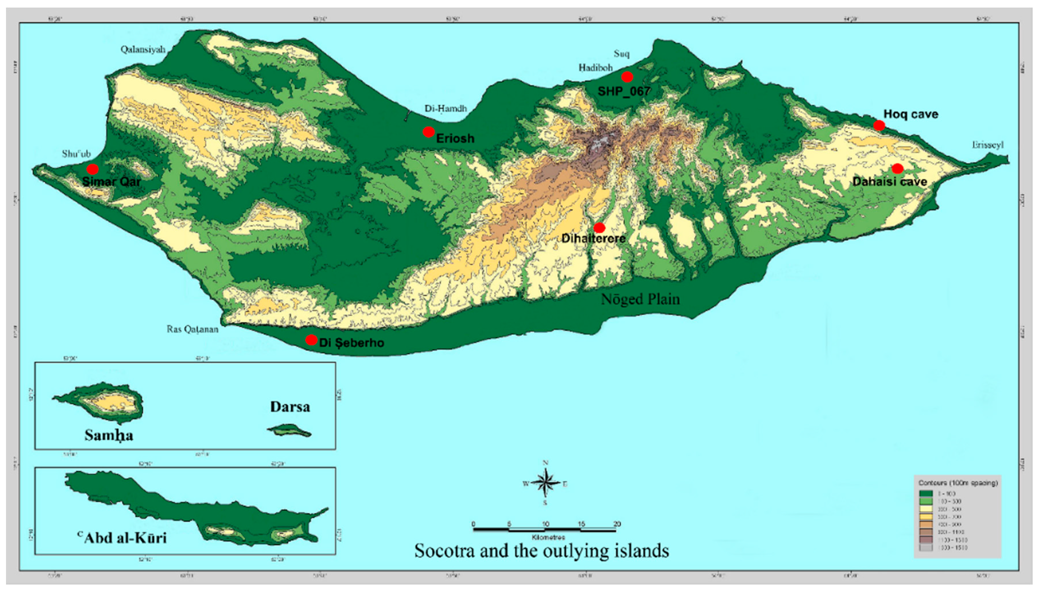
Figure 2.
Map showing the location of the known rock art sites.

Figure 3.
Map of Hoq cave. The numbers mark the location of the rock art.

Figure 4.
Image of a ship believed to date to the 2nd century AD, found at site 6 in Hoq cave (Photo: author).
Figure 4.
Image of a ship believed to date to the 2nd century AD, found at site 6 in Hoq cave (Photo: author).

Figure 5.
Map of Dahaisi cave with the location of the various rock art sites marked in red.

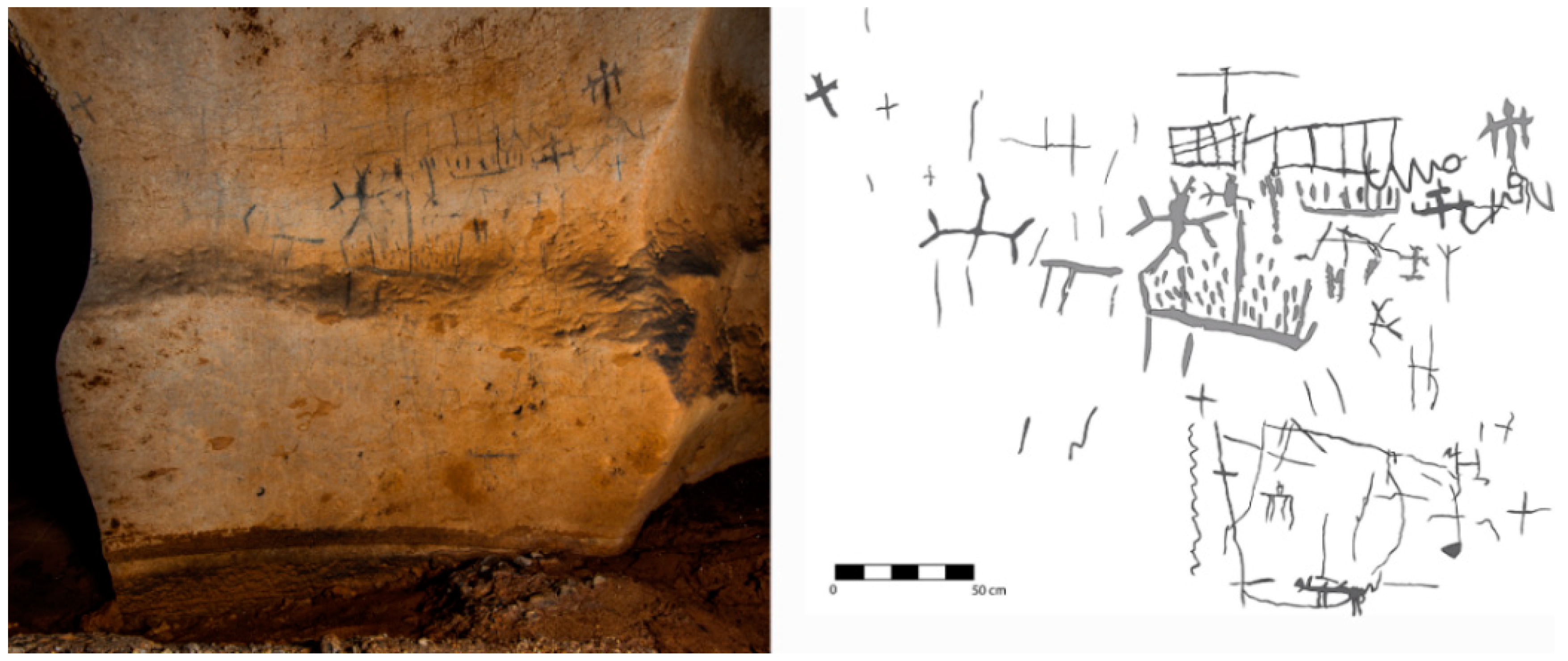
Figure 6.
East-facing photo and line drawing of the motifs found on panel 1 in Dahaisi cave (Photo: author).
Figure 6.
East-facing photo and line drawing of the motifs found on panel 1 in Dahaisi cave (Photo: author).

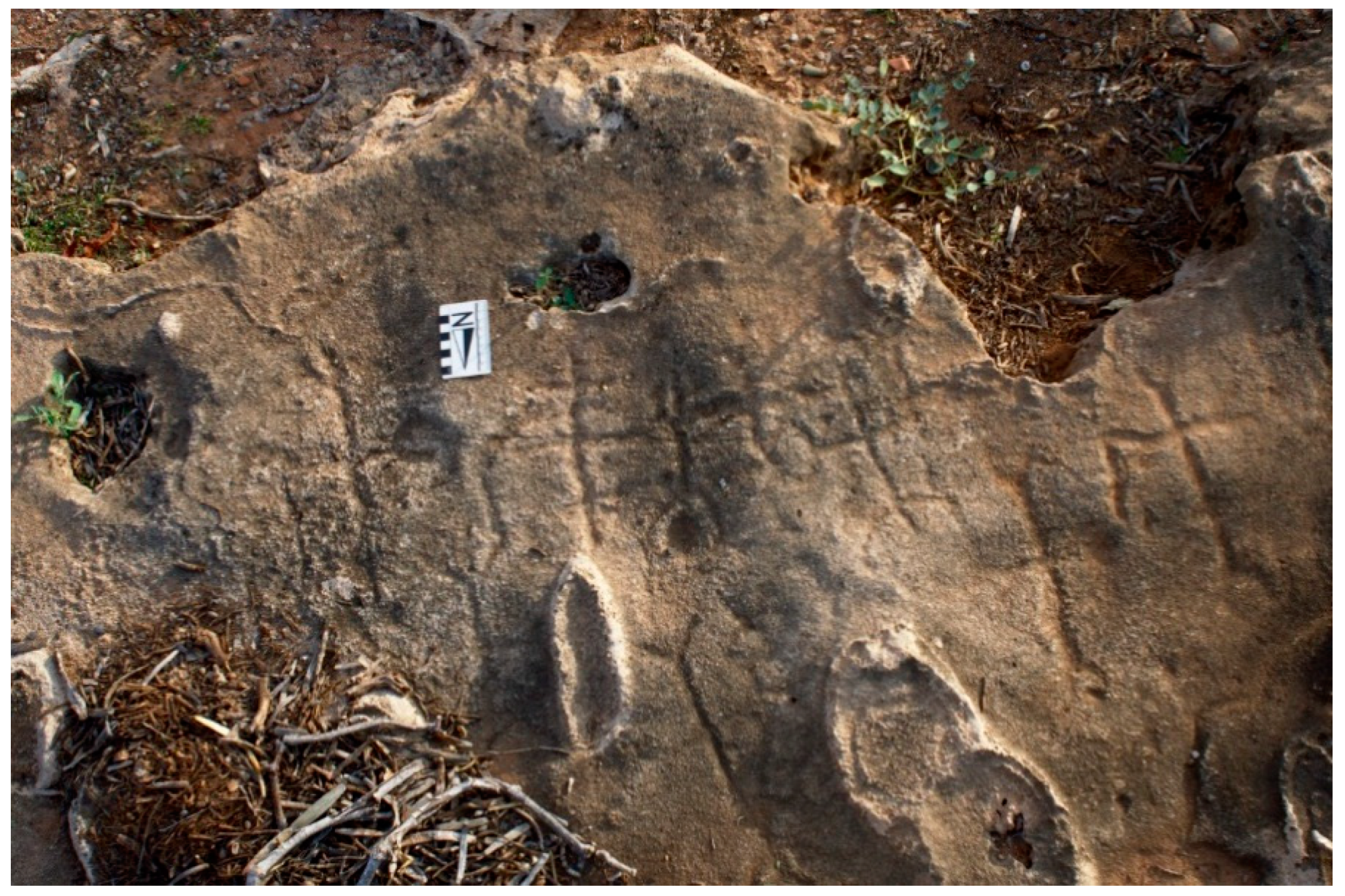
Figure 7.
Overhead image showing a series of foot motifs found at Eriosh (Photo: author).

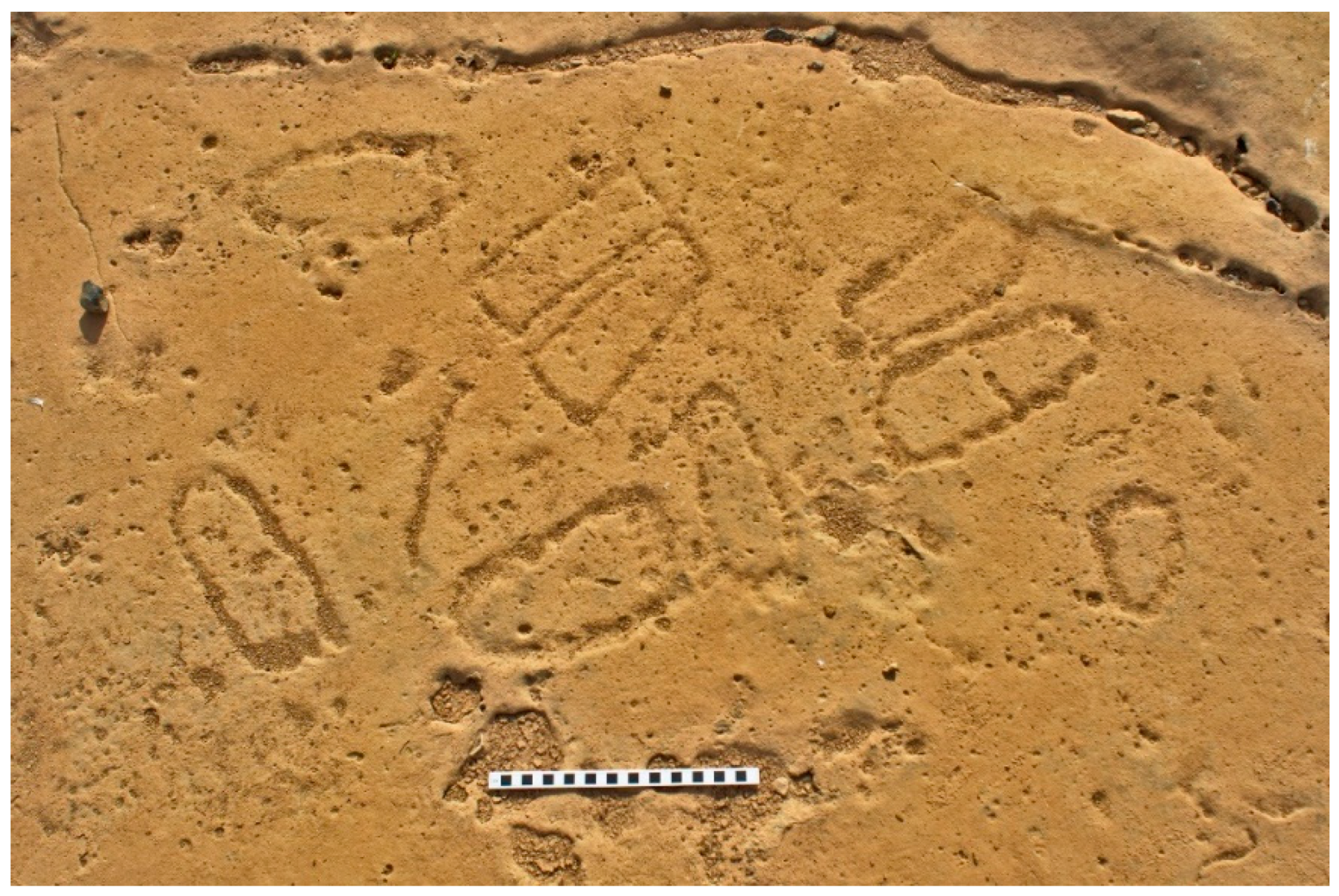
Figure 8.
Overhead image of the densest area of petroglyphs found at SHP_067, showing the cruciform shapes (Photo: author).
Figure 8.
Overhead image of the densest area of petroglyphs found at SHP_067, showing the cruciform shapes (Photo: author).

Figure 9.
Image of the large number of foot motifs found at Di Ṣeberho (Photo: author).

Figure 10.
Image showing the ‘alter’ stone (Photo: author).

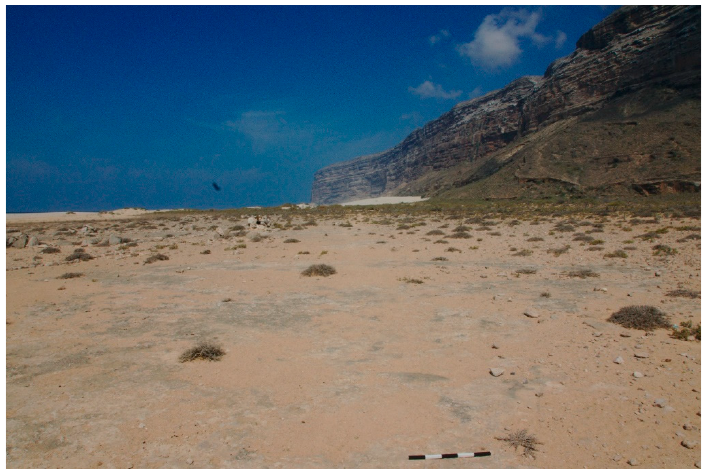
Figure 11.
Westward view over the site of Eriosh showing how the site is submerged during the wet season (Photo: author).
Figure 11.
Westward view over the site of Eriosh showing how the site is submerged during the wet season (Photo: author).

Figure 12.
The water-filled sump in the final chamber of Dahaisi cave (Photo: Dan Britton, used by permission).
Figure 12.
The water-filled sump in the final chamber of Dahaisi cave (Photo: Dan Britton, used by permission).

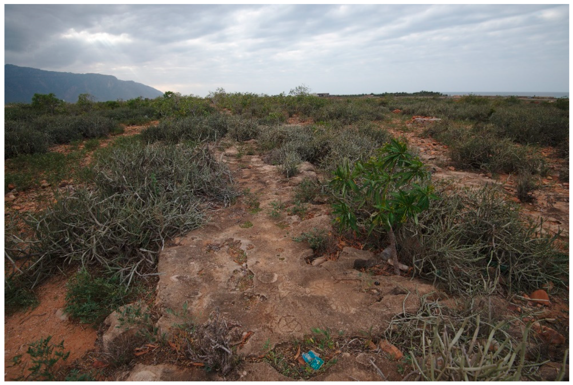
Figure 13.
A westward view over the site of Di Ṣeberho (Photo: author).

Figure 14.
An eastward view of the site of SHP_067 (Photo: author).


Table 1.
A brief synopsis of the location, size, motifs, and period of the sites mentioned in the text.
Table 1.
A brief synopsis of the location, size, motifs, and period of the sites mentioned in the text.
| Site | Location and Size | Motifs | Period |
|---|---|---|---|
| Cave-drawings in the west | Unknown | Unknown | Unknown |
| Hoq cave | North-eastern coast. A 2.5 km long underground gallery. | 248 pictograms consisting of Indian, South Arabian, Ethiopian, Greek and Bactrian inscriptions and images. | 1st century BC to 6th century AD |
| Dahaisi cave | Eastern interior. Momi Plateau. A 175 m long underground gallery. | 104 pictograms that include geometric lines and patterns, cruciform shapes, ships, therianthropic and zoomorphic figures, and an Arabic script. | 1st century BC to 15th century AD |
| Eriosh | North coast. The site spans an area of approximately 10,000 m². | 63 petroglyphs have been recorded. The motifs documented include feet (singularly and in pairs), zoomorphic figures, a South Semitic script, cruciform shapes, anthropomorphic figures, and various geometric patterns. | Doubtful date of 500 BC |
| SHP_067 | North coast, near the village of Suq. The site is 173 m long and spans an area of approximately 1500 m² | 187 petroglyphs that include feet (singularly and in pairs), cupules, a ship, various geometric patterns, cruciform shapes, several plant-like motifs, and a South Semitic script | 4th to arguably the 16th century AD |
| Di Ṣeberho | South-western coast. The actual size of the site remains unclear. | 51 petroglyphs were recorded. These consisted of feet (singularly and in pairs), an orant, hoof prints, and two geometric shapes. | Terminus ante quem of 4th century AD. |
| Simar Qar | West coast. A large cut limestone block. | 5 geometric petroglyphs believed to be an inscription. | Unknown |
| Haidi | North-west coast. A large rock. | An unknown number of petroglyphs believed to be inscriptions, one of which has been identified as a South Semitic script. | Unknown |
| Dihaiterere | Eastern interior. The size of the site is unknown. | 8 petroglyphs were recorded. These consisted of various cruciform shapes. | Unknown |
© 2018 by the author. Licensee MDPI, Basel, Switzerland. This article is an open access article distributed under the terms and conditions of the Creative Commons Attribution (CC BY) license (http://creativecommons.org/licenses/by/4.0/).
Share and Cite
MDPI and ACS Style
Jansen van Rensburg, J. Rock Art of Soqotra, Yemen: A Forgotten Heritage Revisited. Arts 2018, 7, 99. https://doi.org/10.3390/arts7040099
AMA Style
Jansen van Rensburg J. Rock Art of Soqotra, Yemen: A Forgotten Heritage Revisited. Arts. 2018; 7(4):99. https://doi.org/10.3390/arts7040099
Chicago/Turabian StyleJansen van Rensburg, Julian. 2018. "Rock Art of Soqotra, Yemen: A Forgotten Heritage Revisited" Arts 7, no. 4: 99. https://doi.org/10.3390/arts7040099
Note that from the first issue of 2016, this journal uses article numbers instead of page numbers. See further details here.