Article

Transformation of Local People’s Property Rights Induced by New Town Development (Case Studies in Peri-Urban Areas in Indonesia)

by
Rahmat Aris Pratomo
1,2,*,
D. Ary A. Samsura
2,3 and
Erwin van der Krabben
2
1
Department of Urban and Regional Planning, Institut Teknologi Kalimantan, Jl. Soekarno-Hatta Km. 15, Karang Joang, Balikpapan 76127, Kalimantan Timur, Indonesia
2
Institute for Management Research, Department of Geography, Planning and Environment, Radboud University, Heyendaalseweg 141, 6525 AJ Nijmegen, The Netherlands
3
Department of Environment and Urban Studies, UNIKA Soegijapranata, Jl. Pawiyatan Luhur Sel. IV No.1, Semarang 50234, Jawa Tengah, Indonesia
*
Author to whom correspondence should be addressed.
Land 2020, 9(7), 236; https://doi.org/10.3390/land9070236
Submission received: 26 May 2020 / Revised: 3 July 2020 / Accepted: 17 July 2020 / Published: 21 July 2020
(This article belongs to the Special Issue Responsible and Smart Land Management)

Abstract

:
New town development as a form of large-scale development is not a new phenomenon, particularly in developing countries. This development mainly takes place in peri-urban areas due to the high pressure caused by the growing population and the lack of facilities and infrastructure in city centres. As an effect, local communities who originally occupied the land often lose their rights over the property their livelihood might have relied on. Property rights can be grouped differently, classified according to different bundles: appropriation, ownership, and formality of rights. This paper investigates to what extent new town development in Indonesia has affected the property rights of local communities, in terms of the transformation of rights and security level. Moreover, it examines to what extent this transformation has been affected by urbanisation pressure. Ample attention is paid to the transformation of various bundles of rights concerning different usage of property, both residential and cultivated land. A total of 252 questionnaires were distributed to three different locations of new towns in Indonesia. A before-after analysis was employed to identify the transformation of the property rights and their security level, followed by multiple linear regression analysis to observe the influence of the urbanisation pressure to the security level. The research reveals that the transformation of property rights of local residents mainly concerns the appropriation rights. The analysis also indicates that there is a tendency that the security level decreases. Statistically, this appears to be affected by urbanisation pressure variables: type of land, land use, and occupation. With this study, we offer on the one hand a conceptual framework for assessing property rights, while on the other hand, we provide empirical evidence regarding the effects of new town development on property rights transformation and its security level.

1. Introduction

The growing population and the lack of space in cities have become continual challenges faced by urban planners. The United Nations (UN) recorded that the global population living in urban areas accounts for 55% and is projected to increase up to 68% by 2050 [1]. This condition has served as a challenge for people living in city centres in terms of providing their needs for housing, infrastructure, transportation, and so forth [2,3]. As a consequence, urban sprawl occurs, particularly in peri-urban areas [4,5].
Some of these ever-increasing pressures in peri-urban areas involve large-scale land development [6,7]. The emergence of new towns in peri-urban areas can be seen as an example of this large-scale land development [8]. In Indonesia, new town development has been regarded as a solution to resolve urban problems, extending the availability of housing and infrastructure, and reducing disparity in peri-urban areas [9,10,11]. Moreover, this form of large-scale development is also believed to be able to increase land values in peri-urban areas and improve the provision of infrastructure and urban facilities [12,13]. Many scholars discovered that new towns and other large-scale developments cause negative socioeconomic effects [14,15,16], negative effects on biodiversity [17,18], environmental effects [19,20,21], as well as the negative impact on urban health [22]. This may seriously harm the life of the local communities living in the development area. Those people are expropriated from their properties and the property rights over that land [6,23,24,25,26,27]. In many cases, local communities face losses because they heavily rely on those lands to support their livelihoods, while fair compensation for the loss of their property rights over the land cannot be properly secured due to legal uncertainty or unambiguity of the rights [23,28]. This phenomenon can be widely found in developing countries [29,30,31], including Indonesia [6,12].
Property rights, in simple terms, can be defined as a bundle of rights embedded in a property [32,33,34,35]. Regarding land development, property rights should be fully understood as being not only the right to possess the land but also the right to appropriate it [35]. Apart from that, it is essential to understand the formality degree of the rights embedded in the property, since it could play a crucial role in ensuring the legality of the transaction or the exchange process of the rights and its related values [36,37]. By assessing all these rights, a complete understanding of the security level of property rights can be achieved. This is important because, as argued by many scholars, secure property rights are considered as a central determinant of livelihoods for local people and also for economic development in general [38,39,40,41].
To date, studies concerning property rights over land tend to be focused partially on one specific topic, i.e., ownership [26,42,43], appropriation [16,29], as well as the formality of rights [36,37,44]. This paper aims to develop a framework to investigate the different categories of property rights bundles in an integrated way to assess the level of property right security. This framework is then applied to observe how local communities’ property rights and the associated security level have been transformed due to large-scale land development and to assess to what extent urbanisation pressure influences these transformations. Ample attention is paid to the development of new towns and the change of various bundles of rights over both residential and cultivated land and properties. The aim of the paper is, on the one hand, to provide a framework to assess property rights, and on the other hand, to provide evidence regarding the transformation of local communities’ property rights and useful insight on how urbanisation leads to changes in security levels.
Following the introductory section, Section 1, this paper is organised into seven parts. To set the context of this paper, Section 2 discusses trends in large-scale land development, including new town development. Section 3 provides a discussion of the literature on property rights. Also, in this section, a framework for assessing property rights is developed, including the related security level. Section 4 presents our research approach and data collection methods. Section 5 describes the findings of our study, while a discussion of these can be found in Section 6. Conclusions are given in Section 7.

2. Large-Scale Land Development

2.1. Large-Scale Land Development and Driving Forces of Urbanisation Pressure

Development growth is commonly used as a benchmark to determine whether an urban area is successful or productive [45]. Urban development is inseparable from the provision of land [46]. Land development refers to transforming a form and/or function of land for the continuity of activity [47]. Some scholars believe that the greater the needs of land to perform activities, the more intensive the execution of the spatial transformation will be [12,48,49].
Along with the increase of population growth and urban activities, land development is often carried out in a large-scale form. Some scholars have characterised this development as a massive area of development with more varied land uses [8,50]. Evidently, this development also requires high investments [23], provided either by the public sector or private developer [6,51]. A depiction of large-scale land development is illustrated in Figure 1. Although these developments are also discovered in urban areas, they appear to be more prominently developed in peri-urban areas, also known as peri-urbanisation [52,53]. The main reason for this emerging phenomenon is the broader availability of land in urban outskirts at lower prices [51].
Peri-urbanisation involves a penetration process from the city centre to the transition area of rural and urban use [53]. This has become an important discussion topic in Global South countries [48]. Most of the main cities in the Global South that were built in colonial times were not designed for the long purpose. Thus, nowadays, these cities cannot accommodate urban activities and population growth [54]. Furthermore, this phenomenon is characterised by the change of economic structure and community activities from agriculture to nonagriculture, as well as an increase in land prices in the area [55,56,57]. In addition, the unique and dynamic characteristics of peri-urban areas trigger spatial complexities.
The vast large-scale land development in peri-urban areas is inseparable from pressure coming from urban areas. As argued by Li, Sun, and Fang [58], this urbanisation pressure is triggered by geographical, locational, and socioeconomic aspects. The geographical aspect emphasises the type of land and land uses which determine the direction of the expansion of the city [59]. The locational aspect is closely related to accessibility [60,61,62]. Lastly, the socioeconomic aspect relates to land price, occupation, and welfare. The urban expansions usually prefer greenfield locations, assuming both lower land prices and lower servicing costs [59]. In another case, urban pressure seems to be influenced by political decisions [63,64]. The spatial development policy in the peri-urbanisation area—as an outcome of the decision—is believed to be the right decision for urban regeneration due to depressed main cities and their suburban areas [64]. However, other studies have revealed that the development actually enlarges social and economic disparities between residents in the development and surrounding areas [65,66].

2.2. New Towns as a Large-Scale Land Development

Large-scale land development can be categorised into five forms: large-scale infrastructure [67,68], industrial estates [69,70,71], large-scale agricultural investment [72,73], large-scale residential [74,75,76], and new towns [12,77,78]. The development of new towns is considered to be the most dynamic type of development [8], usually involving a substantial amount of land [50,79,80].
In the modern era, the idea of a new town initially goes back to late-nineteenth-century Europe [16], while the concept became more common since the beginning of the twentieth century in the U.S. [8], then followed by Global South countries along with the upcoming of colonialism [81]. In the post-colonialism era, the new town grew for several reasons, such as natural resource exploitation [9], housing provision [74], and improvement of urban facilities [12,75]. In the case of Indonesia, the new town in the post-independence period emerged as an effort to provide new housing outside the core of Jakarta City [82]. Since the early 1990s, many new towns were developed, primarily concentrated within the Jakarta Metropolitan Area as a result of the increasing population growth and scarcity of lands in the city centre [12]. The rapid new town development was also inseparable from the “Repelita IV (Five-Year Development Plan of Indonesia)” policy, which provides an opportunity for private developers to develop new town housing areas [82]. Nowadays, this development trend is widely spread in Indonesia.
The success and direction of new town development cannot be separated from the process, including the roles of stakeholders involved. Since this development requires a high investment, the function of private developers in the development process becomes more crucial. Roles of the developers relate to land acquisition, construction, finance, and management of the developed areas [78]. As a consequence of their dominant position, development relies on economic profits. Meanwhile, the involvement of national and local governments is limited. The national government plays an important role in developing regulation related to large-scale development, whereas the local governments are involved in providing building permissions, monitoring the land use, economic development, and environmental issues of the new town areas [78]. Similar to other countries [83,84,85], new towns in Indonesia are built for upper-middle-income groups [12]. This flow of ‘capitalist’ investments has resulted in new towns becoming rather exclusive. Consequently, local communities are merely positioned as a marginalised object of the development [49]. The people who owned the land are threatened by impacts of the development, primarily transformation of rights over the land.

3. Property Rights over Land

Property rights represent the bundle of rights which describe the relationship between rights holders, either individuals or groups, and their properties [86]. The rights should be understood as the various rights which can be used and allocated to a piece of property [32,34,35,87]. Payne [88] described property rights as an ownership-based relationship between a party and their property. The ownership is defined as varied rights and obligations derived from the laws conferred to the owner of a property to relate with other parties [89]. Rodgers [90] pointed out that formality of rights is inseparable from a property where this right is understood as the right to hold power to enforce property according to rules and policies. With this right, the security of the property will be further stimulated, so is the value of investment [91,92].

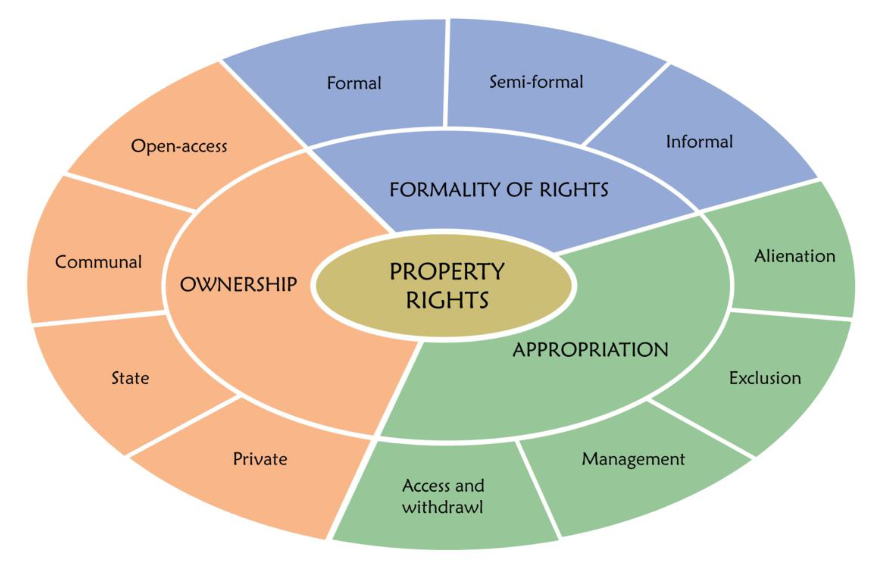
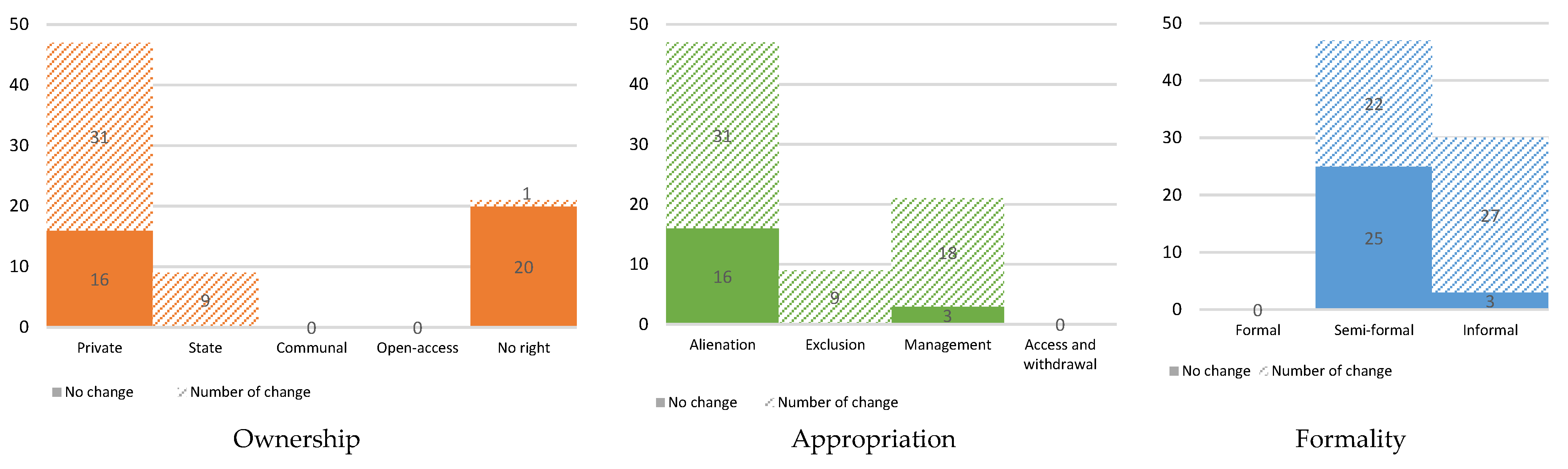
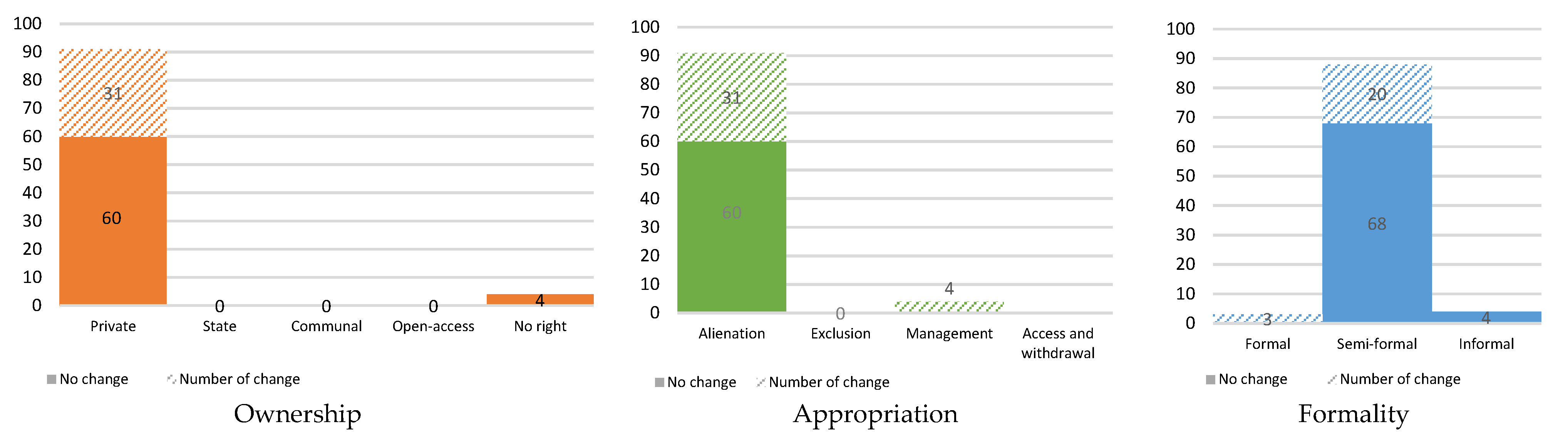
3.1. Different Categories of Property Rights Bundles over Land

In terms of land development, the property is often used and owned by different parties. These various arrangements might be based on varying degrees of the formality of these rights, possibly affecting the transaction process of the rights. In developing countries, for example, many farmers rent their cultivated lands, which means they only hold rights of appropriation on the lands under the ownership of that land by other parties, while the transaction between the owner and the renter/user of the land is based on an informal agreement. In this paper, we distinguish within the property rights bundle ownership, appropriation, and formality of rights. The detailed descriptions of those property rights are provided below, and the summary can be seen in Figure 2.
  • Ownership
Ownership is the right to own a property conferred by a claim or title [88,93]. Concerning the ownership category of property rights, a property can be distinguished based on the different claimants or holders of the right. There are at least four types of the claimant of these rights, including private, state, community, and no one, or hence, everyone [42,94,95]. A private individual as a claimant of the right can either be a person or a corporate organisation. The person who holds this right should be able to receive the benefits from the land in unlimited time, and she/he can individually decide to restrict other people from utilising the property. In his book, De Soto [91] claims that this type of ownership is the success key to maximise the benefits from a property.
With the state as the claimant of the ownership right, a specific state institution or branch of government holds the title over the property. Although the state can be considered as the representative of the public, we can make a distinction between state ownership and public ownership. In the former, the state can exclusively utilise or access the property through its specific institution/branch of government and exclude other individuals from using it, while the latter is available to the entire public for use [87]. We refer to the latter as open-access property in which everyone has a right to claim the use of the property since no one has the title of its ownership. We also distinguish the open-access property from the communal property, which we define as a property jointly owned by a limited group of individuals or a community. This group or community is entitled to exclude other individuals from using the property under some kind of rules or statutes [96]. The group can also make their own decision on who among the members of their group can use the property and how can they use it [35].
In Indonesia, according to the Basic Agrarian Law (BAL or Law No. 5/1960), which is the central legislation governing land rights in the country, private property rights over land are widely recognised. Still, the state has the right to control all land for the benefit of the people [97]. This right to “control” means that the state may impose a rule to regulate and implement a certain utilisation or reservation of land including those that are owned by private individuals and also to regulate legal relations between individuals and legal acts concerning their lands.
The BAL also recognises communal property based on customary law (the land is referred to as tanah ulayat) that already exists since even before the creation of the Indonesian state.1 However, the BAL does not explicitly address the system to regulate this customary land, though the law stipulates that the exercise of the right should not be in conflict with national interests or other regulations set out in the law.
Regarding the land as an open-access property, it is not specifically mentioned or regulated in the law. However, it may exist in case the land is not claimed by anyone, and everyone can access and utilise the land. Given the fact that, at the moment, a systematic land registration is still ongoing in Indonesia and roughly only one-third of all lands in the country have been registered [96], many land parcels remain without a title of ownership which then can be considered as open-access property. Based on the control right of the state over all land in Indonesia, the government may impose a presumption that those unregistered lands are considered as public land until proven otherwise. Moreover, since the state controls of such land have to be exercised for the benefit of the people, the state may allow anybody to access and utilise it [98,99].
  • Appropriation
The notion of appropriation can be equally understood as the term user rights and collective-choice rights, which were introduced by Schlager and Ostrom [35]. This right can be defined as a right to use and allocate the property. According to Schlager and Ostrom, in this sense, property rights over land can be divided into four categories: alienation, exclusion, management, and access-withdrawal [35]. The right to alienate the land or alienation right is defined as the right to manage, use, sell, or to let or execute these simultaneously. The right holders are entitled to receive benefits, to transform, to cultivate, or to convey the property for freedom’s sake to use the property according to their needs. The exclusion right is the right to access a particular property. It also includes the right to choose with whom and how the transaction of the property takes place. The management right can be defined as the right to manage and to change the natural resources by performing maintenance. A person with management right is authorised to decide how, when, and where harvesting will take place and how the property structure can be changed. The final category concerns the access and withdrawal rights. These rights are regarded as the lowest ones in which the rights are held only to take what the property can offer.
In Indonesia, according to the BAL, there are several types of rights related to different appropriation levels that someone can possess over land. These rights include hak milik (freeholds right), hak guna usaha (exploitation right), hak guna bangunan (development or building right), hak pakai (use right), hak sewa (rent or lease right), hak membuka lahan (land clearance right), and hak memungut hasil hutan (right to collect forest products).2 The first four aforementioned rights are called primary rights since they are directly given by the state (with an exception of the use right which can also be given by a private entity who has a freehold right), and they can be sold, mortgaged, and inherited by a legal heir [97].
Among those four rights, hak milik (freehold right) can be considered as the strongest right since the holders of this right can basically use the land for any purpose based on their needs and interest in unlimited terms of time. However, the law also mentions that all land has a social function, which means that the use of land must not be in conflict with the rights of others and the public interest. Given its definition, hak milik can be associated with the alienation right in the Schlager–Ostrom framework of property rights.
The other three primary rights do not have a permanent quality, and they serve as kind of commercial lease rights but for different purposes. Hak guna usaha (exploitation right) can only be used for economic activities including agricultural, fisheries, and animal husbandry. Hak guna bangunan (right to build) is somebody’s right to build and own buildings on land that is not her/his own. While for hak pakai (use right), the holder of this right can use and/or collect products from the land. Although these rights can be transferred [100,101], individuals holding these rights face limitations to the use of land, implying that the owners should fulfil the permits to use of land. Based on the classification by Schlager and Ostrom, those three rights are categorised into exclusion.
The other three rights mentioned in BAL, namely, hak sewa (lease rights), hak membuka lahan (land clearance right), and hak memungut hasil hutan (right to collect forest product), cannot be transferred to other people. For hak sewa, the holder of this right can use and manage the land by paying a fee to the owner of the land for a certain period of time [97]. This right can, therefore, be associated with the management right in the Schlager–Ostrom framework of property rights. Moreover, hak membuka tanah and hak memungut hasil hutan apply to take and catch resources from the land or productive forest [102]; it is classified into access and withdrawal. In addition, related to Indonesia as a maritime nation, hak pemeliharaan dan penangkapan ikan is essential to protect fishermen’s fishery rights in the exclusive economic zone (ZEE) of Indonesia ocean [103].
  • Formality of Rights
The formality of rights is embedded in certain parties based on institutional perspective [36,92,104]. This right guarantees the property value and security of property transaction [39]. There are three categories of this formality: formal, semi-formal, and informal. When someone possesses a formal right over land, she/he has a right to empower and control the property based on rules and institutional provisions [33]. In Indonesia, a formal right is authorised by the Ministry of Land and Spatial Planning/National Land Agency (ATR/BPN) or Land Deed Officials through a formal certificate. Regarding semi-formal rights, the holder of this right has an authority to control her/his property, but it is not fully supported by legal power [105]. Practically, in Indonesia, the right is derived from a letter of agreement such as girik, rincik, letter C, patok D, or SPPT (Notification of Tax due) [37]. The last one, informal right, is defined as a right to control over property [33], through customary law, adat istiadat [106], a letter issued by village headmen [107], or even an oral agreement [105]. The properties embedded with these semi-formal and informal rights are also classified as unregistered [108,109].

3.2. Security Level of Property Rights

Property rights security is increasingly gaining attention in the international literature [110,111,112]. Determining the property rights security level relies on hierarchy in each of the categories of rights. The security level is defined by (1) appropriation rights, (2) ownership rights, and (3) the formality of rights. Appropriation rights determine the security level since they have a direct effect on the freedom to use the property to gain optimal benefits [35]. Based on Schlager and Ostrom’s framework of property rights for appropriation, we distinguish five security levels concerning appropriation. Alienation has the highest level of security since property users can use and cultivate the property nonrestrictively. It allows the users full nonmaterial and material benefits from the property. After that, we distinguish ‘exclusion’, ‘management’, ‘access and withdrawal’, and ‘absence of appropriation rights’. Exclusion and management rights refer to agreements on where the cultivation of the property should comply with. Access and withdrawal rights only give their holders access to the direct benefits from the existing property, without any capacity to transfer or transform the form of the property.
Regarding ownership, the security level cannot be ordered since each right holder is entitled to manage her/his property independently [42]. This implies that the holders have similar roles to access the property, to obtain profits, and to deal with the economic risks. Similarly, in Indonesia, BAL does not make any distinction in terms of security whether the land is owned privately, by organisations, corporately, or under the control of the state, which means that any legal entity has an equal position when they own a piece of land. Therefore, the hierarchy of each category in this right can only be distinguished by whether someone owns the land, with the former possessing a higher security level than the latter.
Considering the formality of rights, a formal right provides the highest level of security, because the holder of this right is strongly protected by formal regulation and the legality of this right secures her/him from being usurped by other parties. Besides, the existence of a formal right could reduce insecurity, giving no space for buyers playing around with the land price [95]. Informal rights have the lowest level of security due to less legality, which could hamper the holder from any transaction, and it could result in low investment value [106]. Moreover, property with informal rights cannot be used as collateral in renting and subletting [37]. Regarding the semi-formal right, its security can be considered to be in between formal and informal rights.

4. Methodology

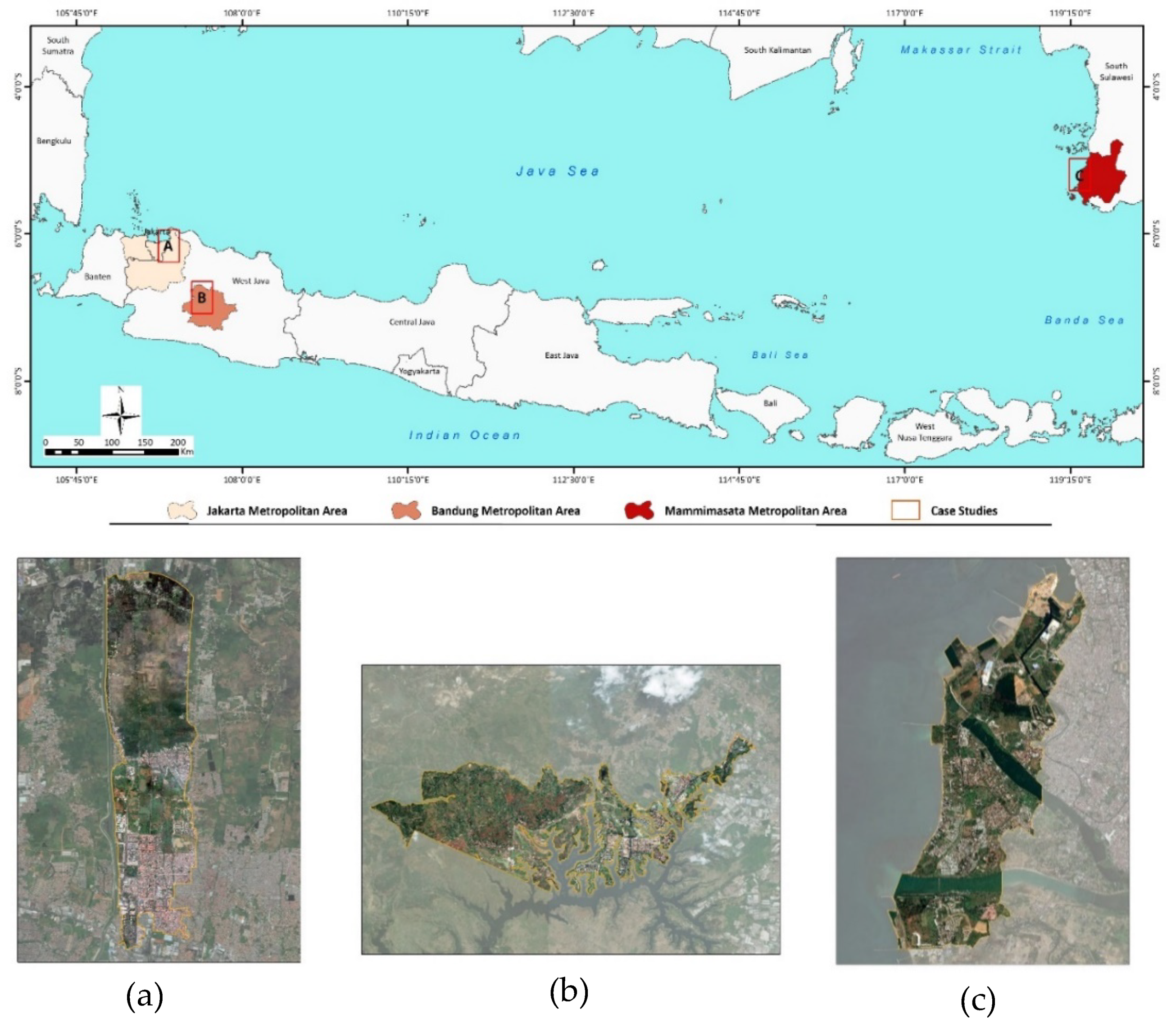
4.1. Research Location

4.1.1. Selection of Case Studies

This research was conducted using a case study of new town development in Indonesia (see Figure 3). It aimed to assess the real condition of property rights transformation of the local communities as a result of the development. Research locations were chosen by considering the characteristics of peri-urban areas where this large-scale land development dominantly takes place. We selected both inland and coastal locations, with different types of economic activities of local people, which is manifest in a different mode of land uses and difference with respect to the bundle of rights [53] (Table 1). In our case studies, we also took account of the long duration of development, i.e., up to 25 years, to fully understand the impact of the development process, i.e., land acquisition. As mentioned by Winarso and Firman [51], large-scale developments often include a gradual land acquisition process. This potentially affects the transformation of local people’s property rights in the development locations.
The basic characteristics of the three locations are shown in Table 1.

4.1.2. The Characteristics of Land Use in Our Case Studies

Land development is marked by the spatial transformations in the new town development area (as presented in Table 2). Before the development, the majority of the lands in KHI (Kota Harapan Indah) and KBP (Kota Baru Parahyangan) were used for agricultural activity, accounting for 70% and 73% of total land use respectively. MTB (Metro Tanjung Bunga) is situated on the west coast of Makassar city; before the development, 40% of the total area was used as fishponds. People’s livelihoods in KHI [114] and KBP [115] are farming; fishing and aquaculture in MTB [117,118].
New town development has transformed the land use to a more urbanised form. Up until 2016, the developed area in KHI expanded by 125%, including residential and supporting facilities. In 2007, the increase of the developed areas accounted for 187% in KBP, and it increased to tenfold, or 329.06 ha, in MTB. At the same time, agricultural and aquaculture lands for fishery have decreased by about 44% in KHI and 65% in MTB. Although the existence of paddy fields tended to represent a huge proportion in KBP, the ownership of the fields had been conveyed to a KBP developer, and the local people only used the lands temporarily.

4.2. Sampling

We employed a purposive sampling method to acquire the entire data. This method is designed to capture information from respondents with some specific criteria involving the people evicted from their land and properties by new town development. Note that, by using this method, the article’s findings cannot be generalised beyond the sample. A total of 252 respondents (Table 3) were obtained from three locations of research, following two-stage data collection. First, interviews were conducted with key respondents: local government, the village head, and the head of community groups (Rukun Warga) to collect information regarding which people’s lands were acquired due to the development. Second, we distributed questionnaires door to door to local people based on the information from the key respondents to obtain information related to property rights. We realise that this method, similar to other nonprobability samplings, is associated with a small number of samples, leaning to data biases. In order to minimise this limitation, the number of respondents was expanded, akin to what some other scholars have done [119,120,121]. Furthermore, the data obtained should also be normally distributed as a prerequisite for parametric statistic [122,123].

4.3. Assessing Transformation and Security Level of Property Rights

To find out property rights transformation for the local communities that have been affected by the new town development, the three types of rights (respectively, appropriation rights, ownership rights, and formality of rights) were analysed. We considered the rights over, respectively, residential and cultivated lands. The former is acknowledged as a basic need of the local residents [124], whereas the latter is strongly related to the property on which economic activities are performed [125].
Comparative data analysis took place by using the initial characteristics of property rights and their current conditions during the development. This step was expected to show a change in each category of rights. Furthermore, we assessed the transformation of the property rights security level (Table 4) using a before–after analysis method. The following are the steps for this analysis:
1.
Identification of the characteristics of the property rights under prior and current development to find out whether a transformation of the rights has taken place.
2.
Calculation of the number of changes that took place in each bundle of rights to determine which bundle mostly experienced transformation.
3.
Determination of the security level. Each bundle had several categories and different hierarchies of security levels. However, each category has the same score (see Section 4). The hierarchy of each category of the bundle of rights is as follows:
4.
Assessment of the security level of each type of property right under current and prior development.
5.
Calculation of the overall transformation of security level (appropriation, ownership, and formality of rights) using the following formula.
Δ S = S S
Δ S = [ W 1 A + W 2 O + W 3 F ] [ W 1 A + W 2 O + W 3 F ]
Notes:
  • ΔS = transformation of property rights;
  • S’ = security level of property rights in current development;
  • S = security level of property rights in prior development;
  • W1,2,3 = weight per property right (in this research, we assumed that weight of each right is similar = 1);
  • A’ = security level of appropriation in current development;
  • A = security level of appropriation in prior development;
  • O’ = security level of ownership in current development;
  • O = security level of ownership in prior development;
  • F’ = security level of formality of rights in current development;
  • F = security level of formality of rights in prior development.
6.
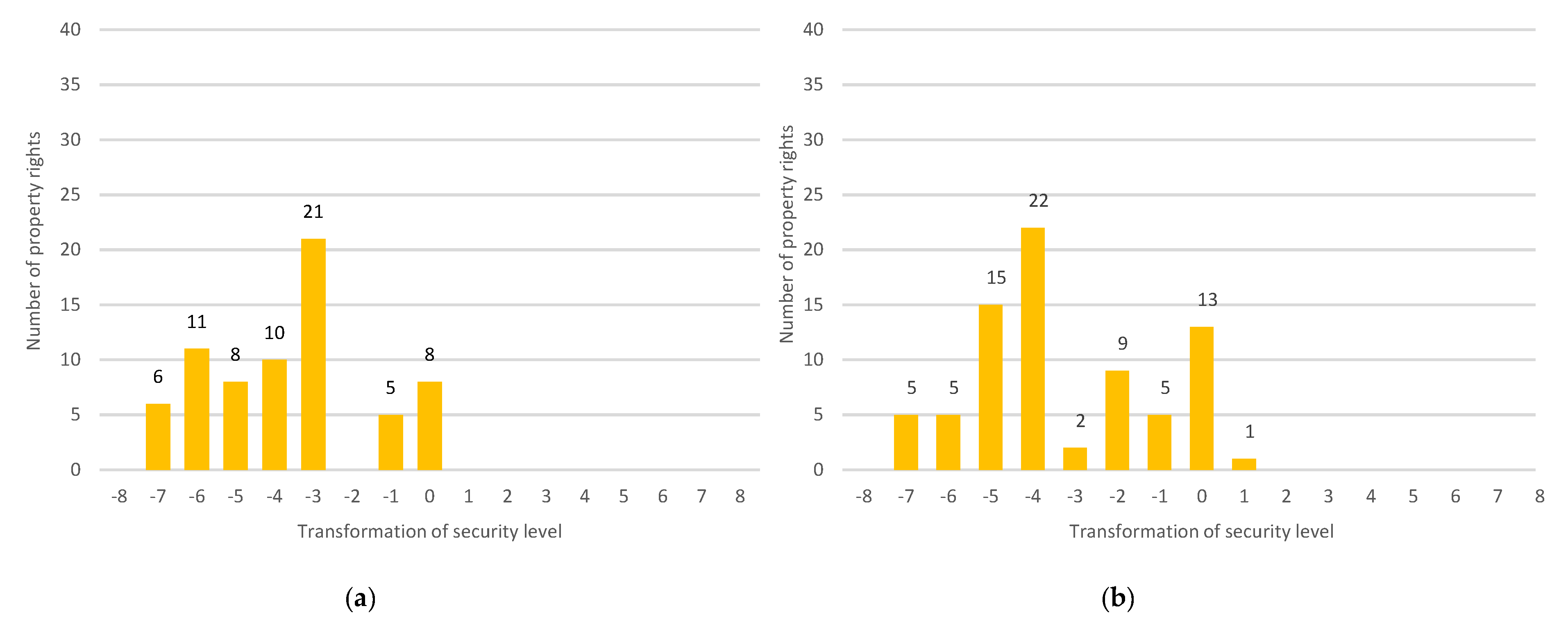
Classification of the changes in security levels of combined rights (ownership, appropriation, and formality). The change of security level shows the magnitude of changes in the security level of property rights. Besides the magnitude, the change also considers the direction of the transformation, i.e., increased (more than 0), no change (0), or decreased (less than 0) (Figure 4).

4.4. Assessing the Influence of Urbanisation on the Security Level of Property Rights
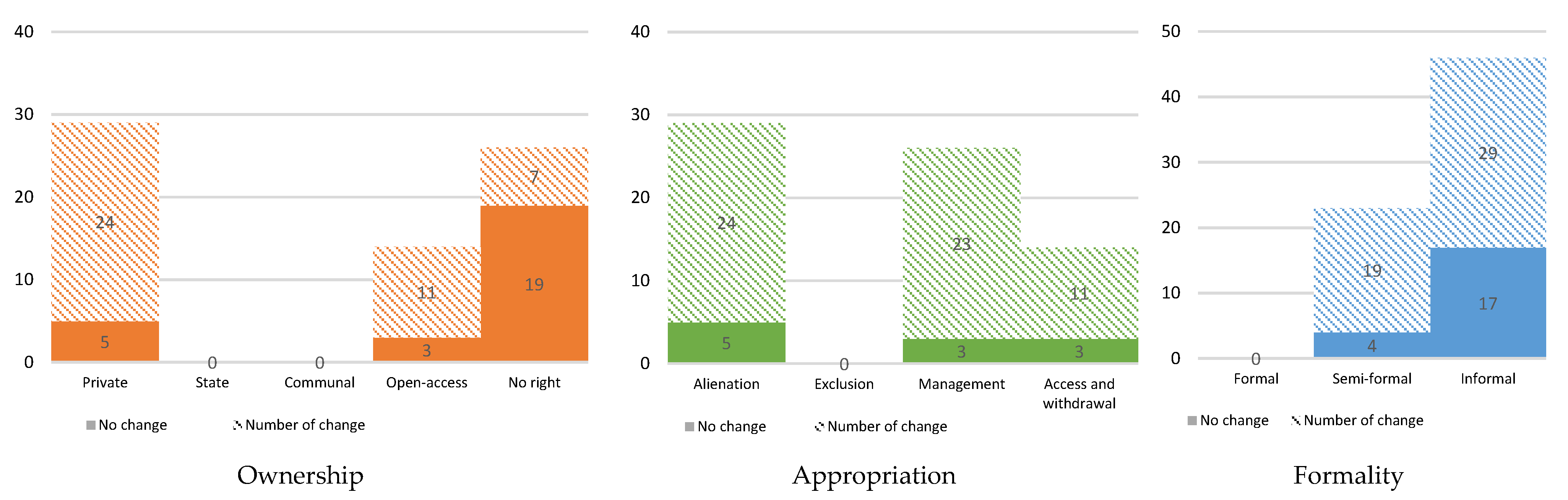
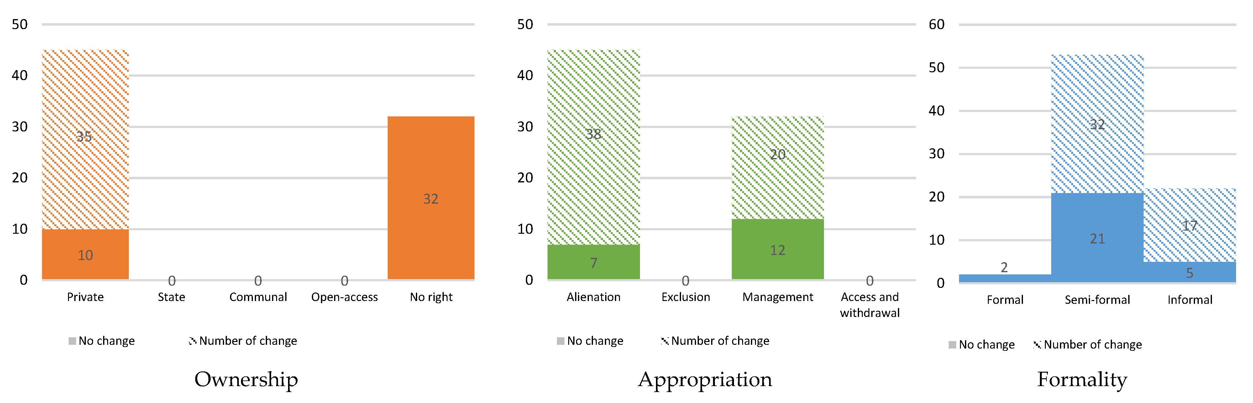
In order to investigate the influence of urbanisation on property rights, a statistical test was performed. By referring to the discussion in Section 2.1, we considered geographical and socioeconomic aspects to analyse the effects of urbanisation since they impose a direct impact on local people in the development area. These two aspects were categorised into six independent variables: type of lands (X1), land use (X2), land price (X3), occupation (X4), income (X5), and welfare (X6). We used dummy data for X1, X2, X4, and X6. The dependent variable (Y) is the change of security level of combined rights (see Section 4.3).
As a first step, the data set was examined by using the Kolmogorov–Smirnov test to check the data’s distribution. The result reveals that Asymp. Sig is 0.0693, which means they were normally distributed (Asymp. Sig. > 0.05). Further, a multiple linear regression (MLR) was employed to help us in modelling the relationship between the dependent and six independent variables as well as to determine which independent variables in particular influence significantly the dependent variable. Initially, we developed hypotheses on this test, as follows:
H0: Urbanisation pressure has a significant influence on the security level of property rights.
H1: Urbanisation pressure does not have a significant influence on the security level of property rights.
Data requirements for this statistical analysis are shown in Table 5.
These hypotheses were developed by considering a common phenomenon in peri-urban regions that high urbanisation pressure significantly triggers a process of land acquisition [60,129]. This acquisition might lead to the change or even loss of local residents’ property rights.

5. Findings

This section describes the transformation of the local residents’ property rights due to the new town development in the three study cases. In addition, his section also provides the results of multiple linear regression (MLR) that analyses the influence of urbanisation on the local people’s security level of property rights over land.

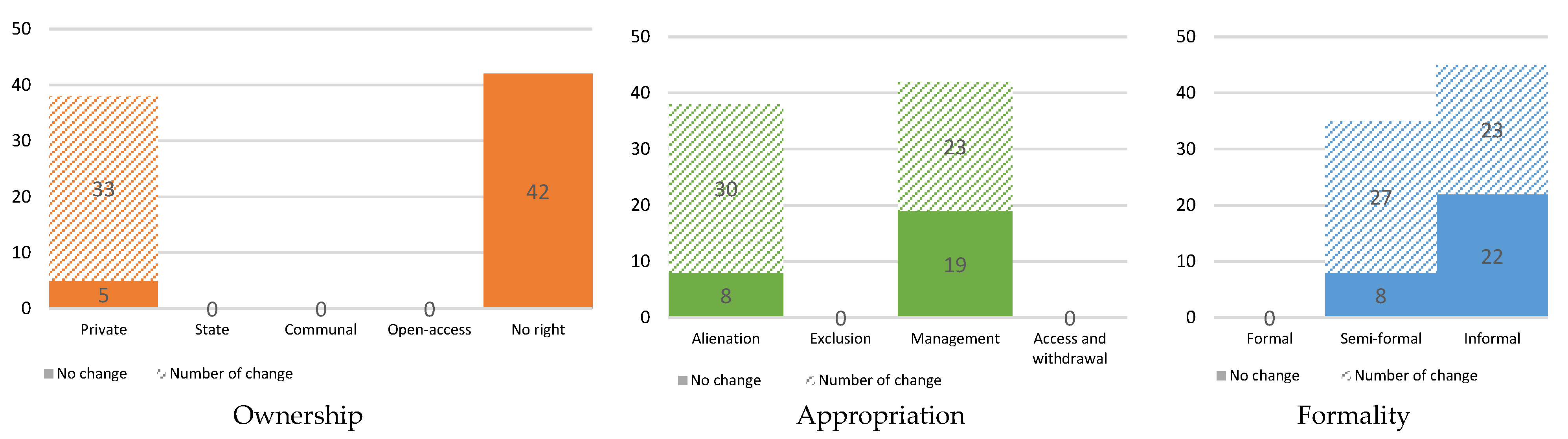
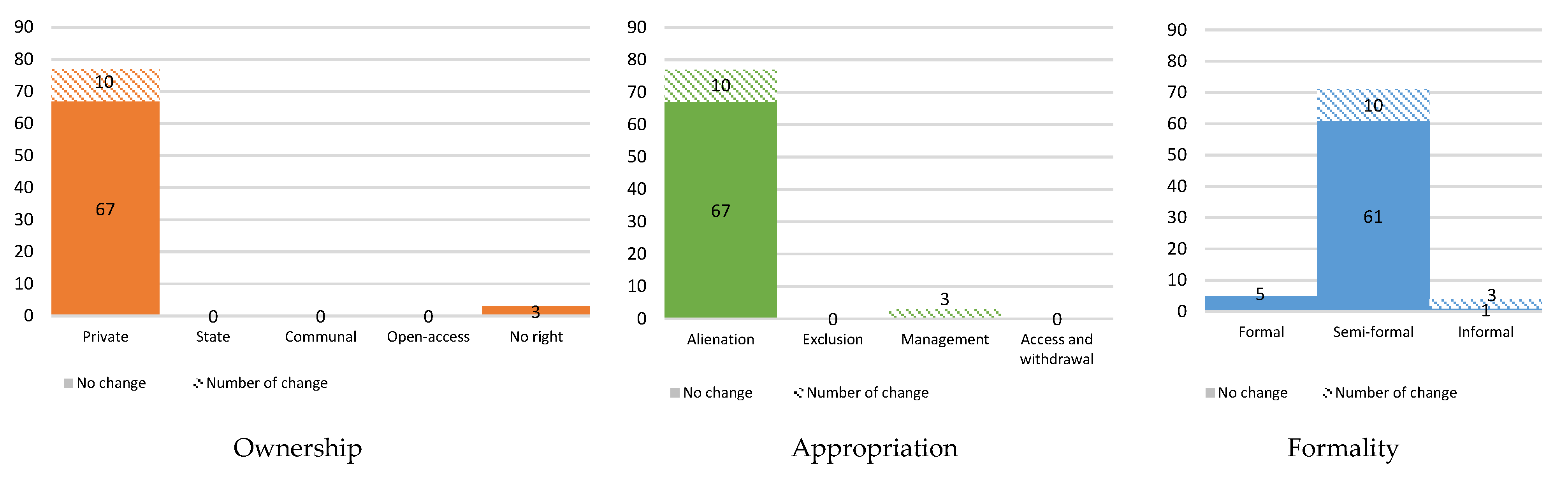
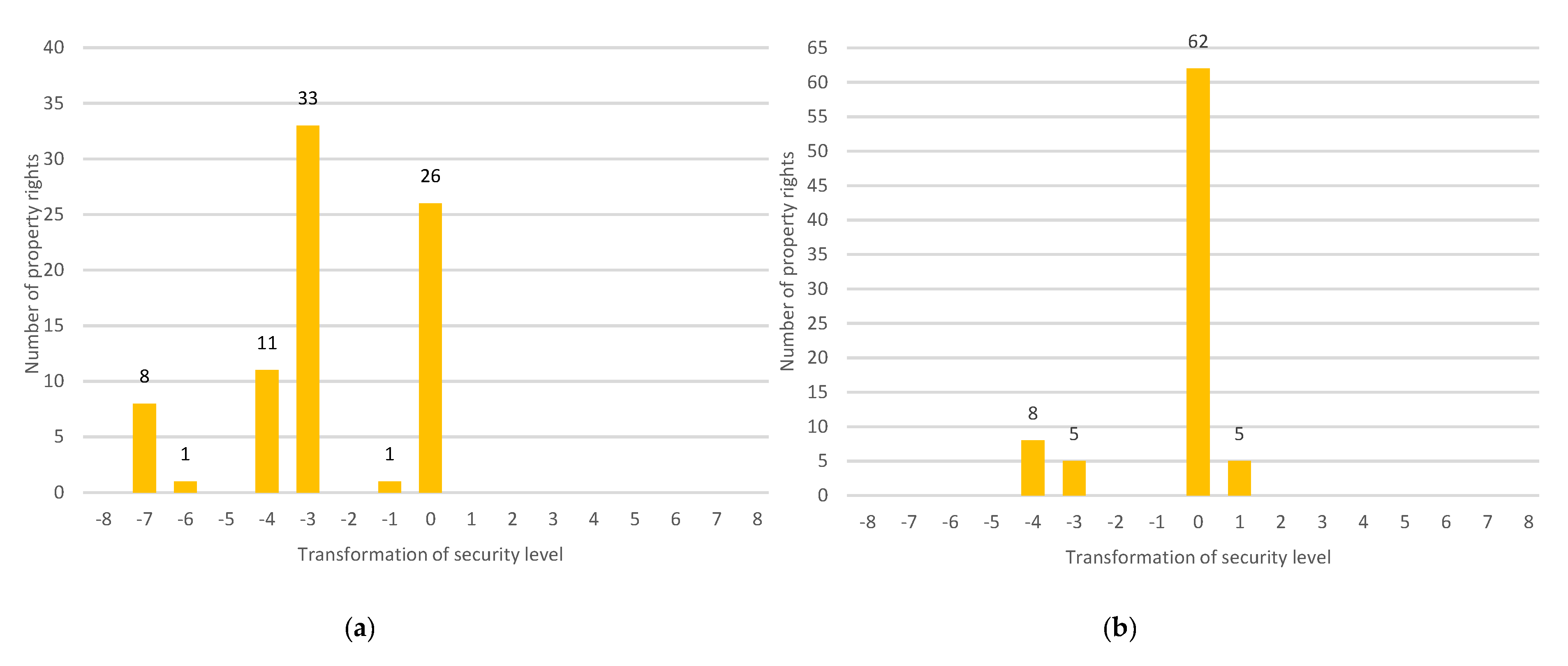
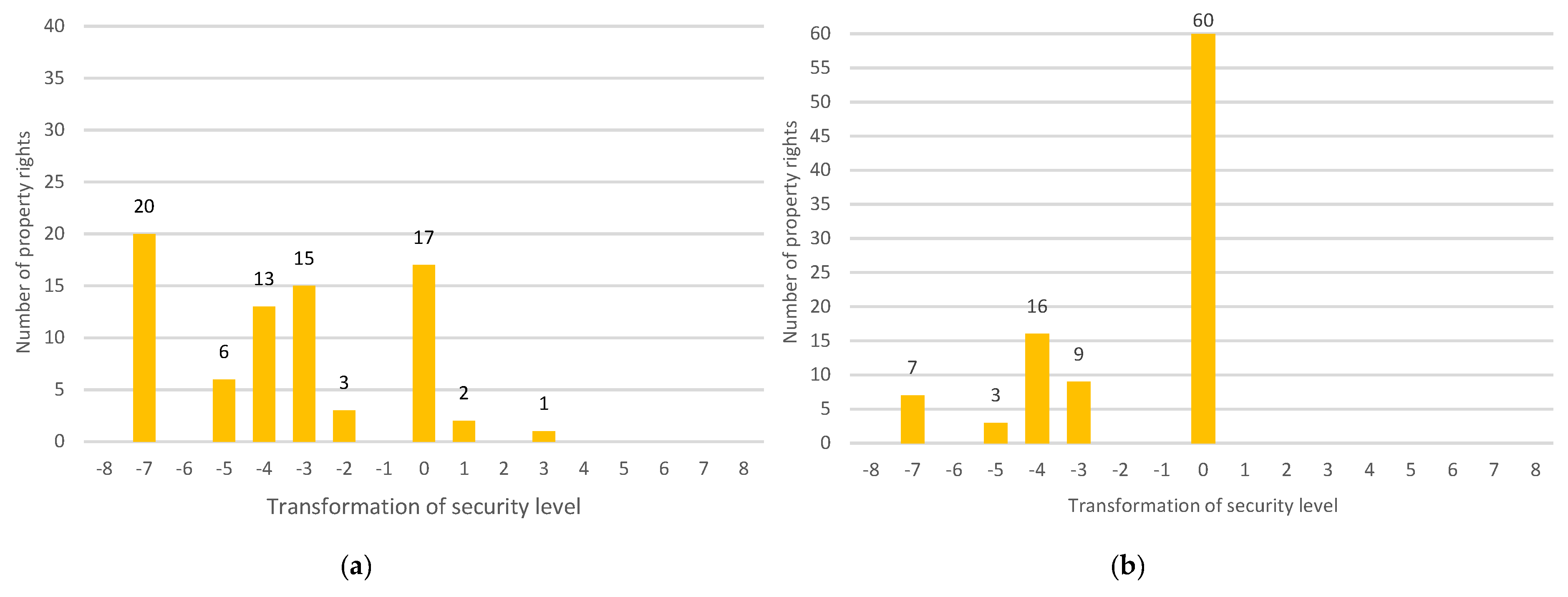
5.1. Transformation of Property Rights

  • Kota Harapan Indah (KHI), Bekasi
Eighty respondents in KHI participated in the survey; 58% of them belong to the lowest income category. Before the development of the new town, 80 rights were attached to the land for residential use and 80 rights to cultivated lands. For the cultivated land, in terms of ownership right, most of the respondents have ‘no ownership’ (53%), while in terms of appropriation rights and formality of the rights, they were dominated by ‘management’ (53%), and ‘informal’ right (56%), respectively, (Figure 5). With regard to residential land, in terms of ownership right, 96% of the respondents held private ownership for their residential lands, and in terms of appropriation right and formality of the rights, they were, respectively, dominated by ‘alienation’ (96%) and ‘semi-formal’ (89%) (Figure 6). It means that the respondents have more freedom over their residential land compared to their cultivated land, since almost all of them hold the private and alienation right for their residential lands.
After the development of the new town, we found that most of the rights over cultivated land were transformed. In terms of ownership right, almost 90% of the ‘private rights’ were changed, while in terms of appropriation rights and formality of the rights, the biggest transformation occurred for ‘alienation’ and ‘semi-formal’ (Figure 5). A similar trend of transformation for the three categories of property rights also took place on the residential lands (Figure 6).
The transformation of the security level of rights after the new town development was more substantial on the cultivated land. As shown in Figure 7a, almost 70% of respondents with cultivated land experienced a decrease in the level of the security of their property rights with the largest decrease of 3 levels. There was no increase in property rights security level for cultivated land after the new town development. For residential land, as shown in Figure 7b, 77% of the respondents experienced a neutral change (the change score = 0) in their property rights security level. Interestingly, 6% of the respondents experienced a slight increase in their property rights security level.
  • Kota Baru Parahyangan (KBP), West Bandung Regency
In KBP, 95 respondents with residential land and 77 respondents with cultivated lands were involved. Before the new town development, the cultivated land was dominated by rice fields and cornfields. In terms of the ownership right, most of the respondents with cultivated land held a ‘private ownership’ (61%), while in terms of the appropriation right and the formality of the rights, most of them held an ‘alienation’ and ‘semi-formal’ right, respectively (Figure 8). A similar situation was also found for residential land (Figure 9).
After the new town development, more than 50% of the property rights for the cultivated land have transformed in terms of all three categories of property rights, while no more than 40% of the property rights for the residential land have changed in terms of all the three categories.
As shown in Figure 10a, with the transformation of the property rights for cultivated land, 57% of the respondents experienced a decrease in their property rights security level with the highest decline of 7 levels. However, a small number of respondents (4%) experienced an increase in the security of their property rights for cultivated land with a rise up to 3 levels. Meanwhile, for the residential land, most of the respondents experienced a neutral change in the security level of their property rights, and none of them experienced an increase of security level (Figure 10b).
  • Metro Tanjung Bunga (MTB), Makassar
In MTB, 69 respondents reported that they had cultivated lands and 77 respondents had residential lands before the development of the new town. The majority of the residents were fishermen or fishpond farmers. In terms of ownership right, 42% of the respondents with cultivated land said that they had ‘private ownership’ rights before new town development which, was the dominant type of rights in this category (Figure 11). Meanwhile, in terms of appropriation rights and formality of the rights, most of the respondents with cultivated land reported that they had ‘alienation’ (42%) and ‘informal’ rights (67%), respectively, before the development. After the development of MTB, 61% of the ownership rights over the cultivated lands have transformed, while 84% and 70% of the appropriation and formality of the rights have transformed, respectively.
Concerning the residential land, the majority of the respondents (58%) reported that they had a ‘private’ right for the ownership category before the development of MTB (Figure 12). During this time, in terms of appropriation and formality of the rights, most of the respondents held the ‘alienation’ right (58%) and ‘semi-formal’ right (69%), respectively. After the development of MTB, 45% of the ownership rights have transformed, while 75% of appropriation rights and 64% of formality of the rights have also changed.
Figure 13a,b demonstrate how the security of property rights for cultivated and residential land has respectively transformed after the development of MTB. It can be seen that most of the rights that have been transformed for both the cultivated and residential land have a decreased level of security. The highest level of decrease for the cultivated land was 3 level, while for the residential land it was 4 level.

5.2. Nexus between Urbanisation Pressure and Security Level of Property Rights

The population growth and increase of public facilities add to higher pressure from the existing city to peri-urban areas. Consequently, the land acquisition that affected the property rights of the residents in our three cases cannot be separated from the urbanisation process. We presume that different aspects of this process, leading to a transformation of the property rights regime, may cause different effects on the security level of property rights. To facilitate the testing of our hypothesis, a multiple linear regression (MLR) was employed by involving the level of property rights security transformation as a dependent variable and the independent variables representing urbanisation aspects, namely type of land, land use, land price, occupation, income, and welfare (see Section 4.4).
In the first step of MLR analysis, we examined the correlation among dependent and independent variables and performance of the regression model. According to Table 6, the R-squared value shows 0.732. This indicates that 73.2% of the transformation of the security level is explained by all variables related to urbanisation. In addition, the Standard Error of the Estimate (SEE) is lower than the standard deviation of dependent variables (2.295 < 2.417), which implies that this MLR model has an excellent performance in predicting the independent variables.
Further, we looked into the coefficients of regression, consisting of β coefficient and significance value. This coefficient explains how and to what extent the urbanisation pressures as independent variables have given an impact on the transformation of security level as the dependent variable. In this sense, the significance of the independent variable is considered when the p-value is less than 0.050. The regression model results are summarised in Table 7, with the coefficients for each variable.
Table 7 shows that three out of six of the urbanisation pressure variables have a significant impact on the transformation of security level of property rights, namely, inland (type of lands), cultivated (land use), and agricultural variable (occupation). Agriculture (X4) has the highest significance with p 0.035 < 0.050, while the type of lands (X1) has the lowest one. Moreover, by referring to the β coefficient, we see that cultivated (X2) and agricultural occupation (X4) have a positive correlation to the transformation, indicating that an increase of the number of cultivated lands and farmers led to a higher value of the transformation of security level: 0.634 points and 0.083 points, respectively. In contrast, inland (type of land) shows an inverse correlation (-1.181) to the change of security level, indicating that the increase in the number of properties in the inland area decreases the security level of property rights concerning the amount of that value.

6. Discussion

6.1. Transformation of Property Rights Due to New Town Development

In terms of land development, property rights cannot only be understood as a single bundle of rights, but they are also attached to several sets of rights at once, which relates to several parties. Therefore, we have proposed here that the assessment of these rights should be performed by taking into consideration the three bundles of rights, namely, ownership, appropriation, and formality of rights. This is reflected in the conceptual framework constructed in Section 3. This new framework also seems workable and helpful for assessing the property rights transformation regarding new town development, because the framework is capable of comprehensively covering and identifying the characteristics of the property rights in the three locations of study. We considered this as an improvement to current frameworks which only focus on ownership [16], appropriation [29], and formality [37] separately. We then applied this specifically to the case of Indonesia. We found that the characteristics of property rights in Indonesia seem to be well represented in our model. Yet, there was one category in ownership that could not be identified in the three locations of study: communal ownership (because this tenure system was not in use in the three research locations). Although communal ownership is acknowledged as one of the categories of ownership in Indonesia, in situations where the properties are usually utilised for public facilities such as waqf for religious activities [96] or it can even turn to ulayat land or adat land [130], private ownership is predominant. Private ownership has been promoted by the government with the intention to bring welfare to the people [131].
The characteristics of peri-urban areas as locations that provide large and fertile land have formed a dependence on the people’s socioeconomic structure towards natural resources [132,133]. The expansion of urban activities in peri-urban areas, often combined with vast land development, has turned into complicated problems in terms of the continuity of the people’s livelihoods. There is much evidence suggesting that, although the locals living in urban outskirts have heavily relied on the availability of lands, their rights to properties are in jeopardy. This issue is apparent in the ownership and utilisation of the properties that are insecure [43,134,135] as well as in the formality of rights [35,115], while the degree of formality plays a central role in providing guarantees for investment values in the transaction of land [80]. Besides the poor economic conditions of local communities, the insecurity of this formality is often overlooked by residents living in peri-urban areas. They are more concerned with maximising the use of land [120,126] rather than holding the lands for economic investment [71].
Unsurprisingly, this condition was also found in the three locations of study: KHI, KBP, and MTB. The initial condition of the rights to the properties held by individuals shows a rather low formality degree. More than 90% of the total property rights were in the category of unregistered rights. In Indonesia, the legality of semi-formal rights stems from the legacy of dualism in the post-colonial land system with different labels in several locations [108]. Girik and Rincik letters can be widely found, where the former is quite common in Java [109], and Rincik is mainly found in Makassar and nearby areas [136]. The characteristics of the property rights mostly found in peri-urban areas reflect poor economic conditions of the locals regarding land registration [111]. Moreover, we also found that, despite similar formality levels between rights over cultivated and residential land, they are different in characteristics in terms of ownership and appropriation. Concerning cultivated lands, the private and alienation right categories are not dominant in ownership right and utilisation. This phenomenon indicates that residents lack full rights to land, such as user rights. As a consequence, they did not get any compensation when their lands were acquired. According to Indonesian Law [137], the compensation given is only restricted to the right of ownership that involves private right, which is mostly associated with alienation right. For residential land, private ownership and alienation rights are dominant. Right holders hold the right to manage their properties in line with their expectation and intention without any interference from other parties. Therefore, these rights give a significant advantage in terms of the guarantee of economic values in land transactions [138] and the sustainability of their livelihoods [128,139].
Along with land acquisition for new town development, the transformation of property rights in the majority of cases led to a change of rights security. Notably, changes in appropriation rights occurred, indicating changes concerning the livelihood of the holders of the rights. Similar changes in livelihood conditions were found in other studies in Global South countries [60,114,132,133].
Additional findings also underline that the rights on cultivated land are easily exposed to the effects of new town development, resulting in substantial decreases in the security level, compared to the changes in security levels for property rights concerning residential use. We assume that this is triggered by lower land prices [111], ‘easier’ land acquisition [134], as well as lower servicing costs [52]. Moving to residential land, we noted that, in total, 172 properties have been acquired, but only in 37% of these cases, this led to a decrease of security level.

6.2. Effects of Urbanisation on the Change of Property Rights Security

The dynamics of the growing population and the development of activities in the existing city have stimulated the expansion of urban activities to peri-urban areas. This major expansion may have been caused by urbanisation pressure consisting of geographical, economic, and social aspects [58,59,60,61,62,126]. This research aimed to verify to what extent urbanisation pressure variables have impacted the security level of the residents’ property rights over land. The results of our statistical analysis indicate that three out of six variables related to urbanisation pressure tested show a significant influence on the change in the security level. They are land use, occupation, and type of lands (Table 7).
Land use seems to be the most significant variable influencing the change of security level. Statistically, it also reveals a positive correlation to the change of security level. The more cultivated lands, the stronger the possibility there will be of a change of the security level. The trend of change of rights in cultivated and residential land in the three locations are 65% and 35%, respectively. The 30% gap indicates the high penetration of large-scale land development which converts productive cultivated lands in peri-urban areas [16,24], most of which are owned by local residents [24,48].
Occupations related to agriculture, e.g., farmer, fisherman, and fishpond farmers, also gives a positive correlation with the change of security level. Referring to Section 5.2, 75% of rights held by farmers, fisherman, or fishpond farmers experienced a substantial decrease in their security level. This finding also asserts that activities in peri-urban areas which heavily rely on agricultural activities [132,133,134] are prone to changes in the security level compared to nonagricultural activities. Farmers tend to easily release their land due to low crop productivity and income [126]. Moreover, in the three locations observed, more than 50% of the locals were holding rights over land where there is a greater chance for a security level change to take place [16]. This led to the significant influence of occupation on the change in security level. In addition, local residents in peri-urban areas tend not to fully understand the benefits of a high security level of their property rights. As long as property rights can provide economic benefits, security levels tend to be ignored [91,140].
On the contrary, although ‘inland area’—an area that is experiencing the most considerable pressure of the development [55]—gives significant influence to the change of security level, this “type of land” shows an inverse correlation to the change. This result proves that not all of the variables which link to the triggering of massive land development [51] have a direct correlation to the transformation of property rights security. Statistically, properties located in inland areas reduce the possibility to change property rights security, whereas the ones in coastal areas receive a more significant change of security level. This is caused by the different livelihoods of local residents: the residents in MTB lose their rights at once as a result of the new town development, since access to the sea is blocked, or the ponds have been taken.

7. Conclusions

This paper has addressed two interrelated issues: the impact of large-scale land development on the transformation of property rights and their security level, and the influence of urbanisation pressures on the change of security level of local communities’ property rights over land. We began with developing an alternative framework to assess the characteristics of property rights, particularly in terms of land development. This framework could comprehensively describe the rights embedded in certain land or other properties by considering three bundles of rights: appropriation, ownership, and formality of right.
We applied this framework to investigate the influence of large-scale urban development on the local communities’ security of property rights over land. The empirical evidence indicates that the degree of formality of property rights in peri-urban areas tends to be rather low in the period prior to new town development, particularly with regard to property rights over cultivated lands. The results of our study also support findings of previous studies emphasising that poor economic conditions and lack of understanding about property rights security hamper the process of legalisation of formal rights. Along with major large-scale land development, the acquisition of the properties of the locals has caused a significant change in their rights. Rights over cultivated land seem more vulnerable to transformation because of lower market value and lower servicing costs. Furthermore, security levels over property rights were affected by several aspects of urbanisation processes, particularly ‘land use’, ‘occupation’, and ‘type of lands’.
In sum, the research results implicitly show that property rights and their security level have a strong relationship with the livelihood of selected local communities in our three research locations. This leads to additional research questions; for instance, what the impact is of the transformation of property rights and related security levels on the quality of the local residents’ life.

Author Contributions

R.A.P.: conceptualisation, methodology, data collection, analysis, writing; D.A.A.S.: conceptualisation, methodology, review, editing, supervision; E.v.d.K.: conceptualisation, review, editing, supervision. All authors have read and agreed to the published version of the manuscript.

Funding

This paper was funded by the Indonesia Endowment Fund for Education (LPDP), Ministry of Finance, Republic of Indonesia.

Acknowledgments

We would like to thank Yayasan Kausa Resiliensi and the students of ITENAS, UNHAS, and BOSOWA University who supported the authors during the fieldwork. The authors would also like to thank anonymous reviewers for their insightful comments and suggestions to the manuscript.

Conflicts of Interest

The authors declared no conflicts of interest.

References

  1. United Nations. World Urbanization Prospects; United Nations: New York, NY, USA, 2018; ISBN 9789211483192. [Google Scholar]
  2. Gong, J.; Chen, W.; Liu, Y.; Wang, J. The intensity changes of urban development land: Implications for the city master plan of Guangzhou, China. Land Use Policy 2014, 40, 91–100. [Google Scholar] [CrossRef]
  3. Zeng, C.; Yang, L.; Dong, J. Management of urban land expansion in China through intensity assessment: A big data perspective. J. Clean. Prod. 2017, 153, 637–647. [Google Scholar] [CrossRef]
  4. Wei, Y.D.; Li, H.; Yue, W. Urban land expansion and regional inequality in transitional China. Landsc. Urban Plan. 2017, 163, 17–31. [Google Scholar] [CrossRef]
  5. Pravitasari, A.E.; Rustiadi, E.; Mulya, S.P.; Setiawan, Y.; Fuadina, L.N.; Murtadho, A. Identifying the driving forces of urban expansion and its environmental impact in Jakarta-Bandung mega urban region. IOP Conf. Ser. Earth Environ. Sci. 2018, 149, 012044. [Google Scholar] [CrossRef] [Green Version]
  6. Firman, T. Rural to urban land conversion in Indonesia during boom and bust periods. Land Use Policy 2000, 17, 13–20. [Google Scholar] [CrossRef]
  7. Diningrat, R.A. Ketergantungan kota baru Kota Harapan Indah terhadap Kota Jakarta dan wilayah sekitarnya. J. Reg. City Plan. 2014, 25, 192–212. [Google Scholar] [CrossRef] [Green Version]
  8. Insa-ciriza, R. Two ways of new towns development: A tale of two cities. In Urban Development; IntechOpen: Rijeka, Croatia, 2012. [Google Scholar]
  9. Sujarto, D. Perkembangan Kota Baru. J. Reg. City Plan. 1993, 9, 3–25. [Google Scholar]
  10. Firman, T.; Dharmapatni, A.Y. The challenges to sustainable development in Jakarta metropolitan region. Habitat Int. 1994, 18, 79–94. [Google Scholar] [CrossRef]
  11. Sujarto, D. The development of metropolitan new towns in Indonesia: With special reference to the city of Jakarta and Jabotabek. In The Indonesian Town Revisited; Nas, P.J.M., Ed.; Institute of Southeast Asian Studies: Singapore, 2003; pp. 76–88. [Google Scholar]
  12. Firman, T. New town development in Jakarta Metropolitan Region: A perspective of spatial segregation. Habitat Int. 2004, 28, 349–368. [Google Scholar] [CrossRef]
  13. Zoomers, E.B.A.; Otsuki, K. Addressing the impacts of large-scale land investments: Re-engaging with livelihood research. Geoforum 2017, 83, 164–171. [Google Scholar] [CrossRef]
  14. Vath Johanna, S.; Gobien, S.; Kirk, M. Socio-economic well-being, contract farming and property rights: Evidence from Ghana. Land Use Policy 2019, 81, 878–888. [Google Scholar] [CrossRef]
  15. Lai, Y.; Peng, Y.; Li, B.; Lin, Y. Industrial land development in urban villages in China: A property rights perspective. Habitat Int. 2014, 41, 185–194. [Google Scholar] [CrossRef] [Green Version]
  16. Adam, A.G. 8Peri-urban land rights in the era of urbanisation in Ethiopia: A property rights approach. Afr. Rev. Econ. Financ. 2014, 6, 120–138. [Google Scholar]
  17. Huang, Y.; Huang, J.L.; Liao, T.J.; Liang, X.; Tian, H. Simulating urban expansion and its impact on functional connectivity in the Three Gorges Reservoir Area. Sci. Total Environ. 2018, 643, 1553–1561. [Google Scholar] [CrossRef] [PubMed]
  18. Jiang, L.; Deng, X.; Seto, K.C. Multi-level modeling of urban expansion and cultivated land conversion for urban hotspot counties in China. Landsc. Urban Plan. 2012, 108, 131–139. [Google Scholar] [CrossRef]
  19. He, C.; Liu, Z.; Tian, J.; Ma, Q. Urban expansion dynamics and natural habitat loss in China: A multiscale landscape perspective. Glob. Chang. Biol. 2014, 20, 2886–2902. [Google Scholar] [CrossRef]
  20. Jiang, L.; Deng, X.; Seto, K.C. The impact of urban expansion on agricultural land use intensity in China. Land Use Policy 2013, 35, 33–39. [Google Scholar] [CrossRef]
  21. Zhao, P.; Luë, B.; de Roo, G. Urban expansion and transportation: The impact of urban form on commuting patterns on the city fringe of Beijing. Environ. Plan. A 2010, 42, 2467–2486. [Google Scholar] [CrossRef]
  22. Capolongo, S.; Rebecchi, A.; Buffoli, M.; Appolloni, L.; Signorelli, C.; Fara, G.M.; D’Alessandro, D. COVID-19 and cities: From urban health strategies to the pandemic challenge. A decalogue of public health opportunities. Acta Biomed. 2020, 91, 13–22. [Google Scholar]
  23. Nolte, K.; Voget-kleschin, L. Consultation in large-scale land acquisitions: An evaluation of three cases in Mali. World Dev. 2014, 64, 654–668. [Google Scholar] [CrossRef]
  24. Phuc, N.Q. Urban land grab or fair urbanisation? In Compulsory Land Acquisition and Sustainable Livelihoods in Hue, Vietnam; Utrecht University: Utrecht, The Netherlands, 2015. [Google Scholar]
  25. Kleemann, L.; Thiele, R. Rural welfare implications of large-scale land acquisitions in Africa: A theoretical framework. Econ. Model. 2015, 51, 269–279. [Google Scholar] [CrossRef] [Green Version]
  26. De, T.; Wang, X.; Wu, L.; Zhao, N. Land ownership and the likelihood of land development at the urban fringe: The case of Shenzhen, China. Habitat Int. 2018, 73, 43–52. [Google Scholar]
  27. Tambang, G.; Frederick, Y.; Armah, A. Land access constraints for communities affected by large-scale land acquisition in Southern Sierra Leone. GeoJournal 2016, 81, 103–122. [Google Scholar]
  28. Firman, T. The continuity and change in mega-urbanisation in Indonesia: A survey of Jakarta—Bandung Region (JBR) development. Habitat Int. 2009, 33, 327–339. [Google Scholar] [CrossRef]
  29. Sikor, T.; He, J.U.N.; Lestrelin, G. Property rights regimes and natural resources: A conceptual analysis revisited. World Dev. 2017, 93, 337–349. [Google Scholar] [CrossRef] [Green Version]
  30. Adam, A.G. Land Tenure in the Changing Peri-Urban Areas of Ethiopia: The Case of Bahir Dar City. Int. J. Urban Reg. Res. 2014, 38, 1970–1984. [Google Scholar] [CrossRef]
  31. Zhu, J. Urban development under ambiguous property rights: A case of China’s transition economy. Int. J. Urban Reg. Res. 2002, 26, 41–57. [Google Scholar] [CrossRef]
  32. Bazelon, D.T. The Paper Economy; Random House: New York, NY, USA, 1963. [Google Scholar]
  33. Snare, F. The concept of property. Am. Philos. Q. 1972, 9, 200–206. [Google Scholar]
  34. Becker, L. Property Rights—Philosophic Foundations; Routledge & Kegal Paul: London, UK, 1977. [Google Scholar]
  35. Schlager, E.; Ostrom, E. Property-rights regimes and natural resources: A conceptual analysis. Land Econ. 1992, 68, 249–262. [Google Scholar] [CrossRef] [Green Version]
  36. Farfan, F. Formal and customary housing tenure initiatives in Bolivia. Habitat Int. 2004, 28, 221–230. [Google Scholar] [CrossRef]
  37. Zhu, J.; Simarmata, H.A. Formal land rights versus informal land rights: Governance for sustainable urbanisation in the Jakarta metropolitan region, Indonesia. Land Use Policy 2015, 43, 63–73. [Google Scholar] [CrossRef]
  38. Asoni, A. Protection of property rights and growth as political equilibria. J. Econ. Surv. 2008, 22, 953–987. [Google Scholar] [CrossRef] [Green Version]
  39. Besley, T.J.; Ghatak, M. The de Soto Effect; Suntory and Toyota International Centres for Economics and Related Disciplines, London School of Economics and Political Science: London, UK, 2009. [Google Scholar]
  40. Durnev, A.; Errunza, V.; Molchanov, A. Property Rights Protection, Corporate Transparency, and Growth. J. Int. Bus. Stud. 2009, 40, 1533–1562. [Google Scholar] [CrossRef] [Green Version]
  41. Galiani, S.; Schargrodsky, E. Property rights for the poor: Effects of land titling. J. Public Econ. 2010, 94, 700–729. [Google Scholar] [CrossRef] [Green Version]
  42. Feder, G.; Feeny, D. Land Tenure and property rights: Theory and implications for development policy. World Bank Econ. Rev. 1991, 1, 135–153. [Google Scholar] [CrossRef]
  43. Feder, G.; Onchan, T. Land Ownership Security and Farm Investment in Thailand. Am. J. Agric. Econ. 1987, 69, 311–320. [Google Scholar] [CrossRef]
  44. Navarro, I.A.; Turnbull, G.K. Property Rights and Urban Development: Initial Title Quality Matters Even When it No Longer Matters. J. Real Estate Financ. Econ. 2014, 49, 1–22. [Google Scholar] [CrossRef]
  45. McGee, T.; Robinson, I. The Mega-Urban Region of Southeast Asia; University of British Columbia Press: Vancouver, BC, Canada, 1995. [Google Scholar]
  46. van der Krabben, E.; Jacobs, H.M. Public land development as a strategic tool for redevelopment: Reflections on the Dutch experience. Land Use Policy 2013, 30, 774–783. [Google Scholar] [CrossRef]
  47. Healey, P.; Barrett, S.M. Structure and agency in land and property development processes: Some ideas for research. Urban Stud. 1990, 27, 89–103. [Google Scholar] [CrossRef]
  48. Winarso, H.; Hudalah, D.; Firman, T. Peri-urban transformation in the Jakarta metropolitan area. Habitat Int. 2015, 49, 221–229. [Google Scholar] [CrossRef]
  49. Gong, J.; Hu, Z.; Chen, W.; Liu, Y.; Wang, J. Urban expansion dynamics and modes in metropolitan Guangzhou, China. Land Use Policy 2018, 72, 100–109. [Google Scholar] [CrossRef]
  50. Eichler, E.; Kaplan, M. The Community Builders; University of California Press: Berkeley, CA, USA, 1967. [Google Scholar]
  51. Winarso, H.; Firman, T. Residential land development in Jabotabek, Indonesia: Triggering economic crisis? Habitat Int. 2002, 26, 487–506. [Google Scholar] [CrossRef]
  52. Legates, R.; Hudalah, D. Peri-urban planning for developing East Asia: Learning from Chengdu, China and Yogyakarta/Kartamantul, Indonesia. J. Urban Aff. 2014, 36, 334–353. [Google Scholar] [CrossRef]
  53. Webster, D. On the Edge: Shaping the Future of Peri-Urban East Asia; Shorenstein APARC: Stanford, CA, USA, 2002. [Google Scholar]
  54. Niessen, N. Municipal Government in Indonesia: Policy, Law, and Practice of Decentralization and Urban Spatial Planning; University Leiden: Leiden, The Netherlands, 1999. [Google Scholar]
  55. Bartels, L.E.; Bruns, A.; Simon, D. Towards situated analyses of uneven peri-urbanisation: An (urban) political ecology perspective. Antipode 2020, 1–22. [Google Scholar] [CrossRef] [Green Version]
  56. Woltjer, J. A global review on peri-urban development and planning. J. Reg. City Plan. 2014, 25, 1–16. [Google Scholar]
  57. Rauws, W.S.; De Roo, G. Exploring transitions in the peri-urban area. Plan. Theory Pract. 2011, 12, 269–284. [Google Scholar] [CrossRef] [Green Version]
  58. Li, G.; Sun, S.; Fang, C. The varying driving forces of urban expansion in China: Insights from a spatial-temporal analysis. Landsc. Urban Plan. 2018, 174, 63–77. [Google Scholar] [CrossRef]
  59. Tong, D.; Yuan, Y.; Wang, X.; Wu, L. Spatially varying relationships between land ownership and land development at the urban fringe: A case study of Shenzhen, China. Cities 2019, 1–15. [Google Scholar] [CrossRef]
  60. Wu, F.; Yeh, A.G. Changing spatial distribution and determinants of land development in Chinese cities in the transition from a centrally planned economy to a socialist market economy: A Case study of Guangzhou. Urban Stud. 1997, 34, 1851–1879. [Google Scholar] [CrossRef]
  61. Liu, Y.; Yue, W.; Fan, P. Spatial determinants of urban land conversion in large Chinese cities: A case of Hangzhou. Environ. Plan. B Plan. Des. 2011, 38, 706–725. [Google Scholar] [CrossRef]
  62. Verburg, P.H.; Ritsema van Eck, J.R.; de Nijs, T.C.M.; Dijst, M.J.; Schot, P. Determinants of land-use change patterns in the Netherlands. Environ. Plan. B Plan. Des. 2004, 31, 125–150. [Google Scholar] [CrossRef] [Green Version]
  63. da Silva, R.F.B.; Batistella, M.; Moran, E.F. Regional socioeconomic changes affecting rural area livelihoods and Atlantic forest transitions. Land 2018, 7, 125. [Google Scholar] [CrossRef] [Green Version]
  64. Tarazona Vento, A. Mega-project meltdown: Post-politics, neoliberal urban regeneration and Valencia’s fiscal crisis. Urban Stud. 2017, 54, 68–84. [Google Scholar] [CrossRef]
  65. Evans, G. Measure for measure: Evaluating the evidence of culture’s contribution to regeneration. Urban Stud. 2005, 42, 959–983. [Google Scholar] [CrossRef]
  66. Hall, T.; Hubbard, P. The entrepreneurial city: New urban politics, new urban geographies? Prog. Hum. Geography. 1996, 20, 153–174. [Google Scholar] [CrossRef]
  67. Mok Yan, K.; Sheng, G.Q.; Yang, J. Stakeholder management studies in mega construction projects: A review and future directions. JPMA 2015, 33, 446–457. [Google Scholar]
  68. Zoomers, A.; Noorloos, F.V.A.N.; Otsuki, K.E.I.; Steel, G.; Westen, G.V.A.N. The Rush for Land in an Urbanizing World: From Land Grabbing Toward Developing Safe, Resilient, and Sustainable Cities and Landscapes. World Dev. 2017, 92, 242–252. [Google Scholar] [CrossRef]
  69. Huang, Y.; Yang, D.L. The Political Dynamics of Regulatory Change: Speculation and regulation in the real estate sector. J. Contemp. China 1996, 5, 171–185. [Google Scholar] [CrossRef]
  70. Cartier, C. Land development, regulation theory, and the regional economy in South China. Asian Geogr. 2002, 21, 37–41. [Google Scholar] [CrossRef]
  71. Zhang, L.; Yue, W.; Liu, Y.; Fan, P.; Wei, Y.D. Suburban industrial land development in transitional China: Spatial restructuring and determinants. Cities 2018, 78, 96–107. [Google Scholar] [CrossRef]
  72. Deininger, K.; Binswanger, H.P. Rent seeking and the development of large-scale agriculture in Kenya, South Africa, and Zimbabwe. Econ. Dev. Cult. Chang. 1995, 43, 493–522. [Google Scholar] [CrossRef]
  73. Zaehringer, J.G.; Wambugu, G.; Kiteme, B.; Eckert, S. How do large-scale agricultural investments affect land use and the environment on the western slopes of Mount Kenya? Empirical evidence based on small-scale farmers’ perceptions and remote sensing. J. Environ. Manag. 2018, 213, 79–89. [Google Scholar] [CrossRef] [PubMed] [Green Version]
  74. Ott, S.H.; Hughen, W.K.; Read, D.C. Optimal phasing and inventory decisions for large-scale residential development projects. J. Real Estate Financ. Econ. 2012, 45, 888–918. [Google Scholar] [CrossRef]
  75. Guan, J.; Yang, D. Residents’ characteristics and transport policy analysis in large-scale residential areas on a city periphery: Case study of Jinhexincheng, Shanghai, China. Transp. Res. Rec. 2015, 2512, 11–21. [Google Scholar] [CrossRef]
  76. Al-Shihri, F.S. Impacts of large-scale residential projects on urban sustainability in Dammam Metropolitan Area, Saudi Arabia. Habitat Int. 2016, 56, 201–211. [Google Scholar] [CrossRef]
  77. Wang, A.Q.; Chan, E.H.W.; Yeung, S.C.W.; Han, J.B. Urban fringe land use transitions in Hong Kong: From new towns to new development areas. Procedia Eng. 2017, 198, 707–719. [Google Scholar] [CrossRef]
  78. Dieleman, M. New town development in Indonesia renegotiating, shaping, and replacing institutions. Soc. Sci. Southeast Asia 2011, 167, 60–85. [Google Scholar] [CrossRef] [Green Version]
  79. Griffin, N. The Genesis of a New Community; Urban Land Institute: Washington, DC, USA, 1974. [Google Scholar]
  80. Gakenheimer, R. New Towns In-Town for Developing Countries: A Comment. Urban Stud. 1976, 13, 51–54. [Google Scholar] [CrossRef]
  81. International New Town Institute. Rising in the East: Contemporary New Towns in Asia; SUN Architecture: Amsterdam, The Netherlands, 2011. [Google Scholar]
  82. Karyoedi, M. Pembangunan Kota Baru di Indonesia. J. Reg. City Plan. 1993, 9, 35–40. [Google Scholar]
  83. Blakely, E.J.; Snyder, M.G. Forting up: Gated community in the United States. J. Archit. Plan. Res. 2017, 15, 61–72. [Google Scholar]
  84. Borsdorf, A.; Hidalgo, R.; Sánchez, R. A new model of urban development in Latin America: The gated communities and fenced cities in the metropolitan areas of Santiago de Chile and Valparaíso. Cities 2007, 24, 365–378. [Google Scholar] [CrossRef]
  85. Kuppinger, P. Exclusive greenery: New gated communities in Cairo. City Soc. 2004, 16, 35–61. [Google Scholar] [CrossRef] [Green Version]
  86. Commons, J.R. Legal Foundations of Capitalism; University of Wisconsin Press: Madison, WI, USA, 1968. [Google Scholar]
  87. Reeve, A. Property; Macmillan: London, UK, 1986. [Google Scholar]
  88. Payne, G. Urban Land Tenure and Property Rights in Developing Countries; Practical Action Publishing: Warwickshire, UK, 1997. [Google Scholar]
  89. Demsetz, H.; Alchian, A. The Property Right Paradigm. J. Econ. Hist. 1973, 33, 16–27. [Google Scholar]
  90. Rodgers, C. Property rights, land use and the rural environment: A case for Reform. Land Use Policy 2009, 26, 134–141. [Google Scholar] [CrossRef]
  91. De Soto, H. The Mystery of Capital: Why Capitalism Triumphs in the West and Fails Everywhere Else; Basic Books: New York, NY, USA, 2000. [Google Scholar]
  92. Lanjouw, J.O.; Levy, P.I. Untitled: A study of formal and informal property rights in Urban Ecuador. Econ. J. 2002, 112, 986–1019. [Google Scholar] [CrossRef] [Green Version]
  93. Demsetz, H. Toward a theory of property rights. Am. Econ. Rev. 1967, 57, 347–359. [Google Scholar]
  94. Burger, J.; Gochfeld, M. The tragedy of the commons 30 years later. Environ. Sci. Policy Sustain. Dev. 1998, 40, 4–13. [Google Scholar] [CrossRef]
  95. Payne, G. Land tenure and property rights: An introduction. Habitat Int. 2004, 28, 167–179. [Google Scholar] [CrossRef]
  96. Rudiarto, I. Land Tenure Security in Indonesia. In Land Tenure Security in Selected Countries: Global Report; Leiden University Press: Leiden, The Netherlands, 2015; pp. 1–339. ISBN 9789211326802. [Google Scholar]
  97. Pemerintah Republik Indonesia. Undang-Undang Nomor 5 tahun 1960 tentang Peraturan Dasar Pokok-Pokok Agraria; Pemerintah Republik Indonesia: Jakarta, Indonesia, 1960.
  98. Mitchell, D.; Clarke, M.; Baxter, J. Evaluating land administration projects in developing countries. Land Use Policy 2008, 25, 464–473. [Google Scholar] [CrossRef]
  99. Thorburn, C.C. The plot thickens: Land administration and policy in post-new order Indonesia. Asia Pasific Viewp. 2004, 45, 33–49. [Google Scholar] [CrossRef]
  100. Pemerintah Republik Indonesia. Peraturan Pemerintah Republik Indonesia Nomor 40 tahun 1996 tentang Hak Guna Usaha, Hak Guna Bangunan, dan Hak Pakai atas Tanah; Pemerintah Republik Indonesia: Jakarta, Indonesia, 1996.
  101. Menteri Agraria dan Tata Ruang. Peraturan Menteri Agraria dan Tata Ruang/Kepala Badan Pertanahan Nasional No. 7 tahun 2017 tentang Pengaturan dan Tata Cara Penetapan Hak Guna Usaha; Pemerintah Republik Indonesia: Jakarta, Indonesia, 2017.
  102. Pemerintah Republik Indonesia. Peraturan Pemerintah Republik Indonesia Nomor 6 tahun 1999 tentang Pengusahaan Hutan dan Pemungutan Hasil Hutan pada Hutan Produksi; Pemerintah Republik Indonesia: Jakarta, Indonesia, 1999.
  103. Pemerintah Republik Indonesia. Peraturan Pemerintah (PP) No. 15/1984 tentang Pengelolaan Sumber Daya Alam Hayati di Zona Ekonomi Eksklusif (ZEE) Indonesia; Pemerintah Republik Indonesia: Jakarta, Indonesia, 1984.
  104. Roth, M.; Smith, S.G. Land Tenure, Land Markets, and Instituional Transformation in Zambia; University of Wisconsin-Madison: Madison, WI, USA, 1995. [Google Scholar]
  105. Winayanti, L.; Lang, H.C. Provision of urban services in an informal settlement: A case study of Kampung Penas Tanggul, Jakarta. Habitat Int. 2004, 28, 41–65. [Google Scholar] [CrossRef]
  106. Aredo, D. Review of Theories on Land Tenure and Country Experiences; The Ethiopian Economic Association Working Paper Series; Ethiopian Economic Association: Addis Ababa, Ethiopia, 2003. [Google Scholar]
  107. Li, T. Local histories, global markets: Cocoa and class in upland Sulawesi. Dev. Chang. 2002, 33, 415–437. [Google Scholar]
  108. Hoffman, M.L. Unregistered land, informal housing, and the spatial development of Jakarta. In Spatial Development in Indonesia: Review and Prospects; Kim, T., Knaap, G.H., Eds.; Aldershot etc: Avebury, UK, 1992. [Google Scholar]
  109. Leaf, M. Land Rights for residential development in Jakarta, Indonesia: The colonial roots of contemporary urban dualism. Int. J. Urban Reg. Res. 1993, 17, 477–491. [Google Scholar] [CrossRef]
  110. Alchian, A.A.; Demsetz, H. Production, information Costs. Am. Econ. Rev. 1972, 62, 777–795. [Google Scholar]
  111. Lawson-remer, T. Security of property rights for whom? Dev. Stud. 2014, 818, 319–342. [Google Scholar] [CrossRef]
  112. UN-Habitat. Land Tenure Security in Kenya in Land Tenure Security in Selected Countries; United Nations: New York, NY, USA, 2015; ISBN 9789211326802. [Google Scholar]
  113. Bureau Statistics of Bekasi City. Statistics of Bekasi City; Bureau Statistics of Bekasi City: Bekasi, Indonesia, 2002. [Google Scholar]
  114. Bureau Statistics of Bekasi Regency. Statistics of Bekasi Regency; Bureau Statistics of Bekasi Regency: Bekasi Regency, Indonesia, 2002. [Google Scholar]
  115. Bureau Statistics of West Bandung Regency. Statistics of West Bandung Regency; Bureau Statistics of West Bandung Regency: West Bandung Regency, Indonesia, 1996. [Google Scholar]
  116. Megawati, D.R.; Ju, S.R.; Hanan, H. The trend of housing design and town planning of new towns in Indonesia. J. Korean Hous. Assoc. 2014, 25, 11–20. [Google Scholar] [CrossRef]
  117. Bureau Statistics of Makassar city. Statistics of Makassar; Bureau Statistics of Makassar City: Makassar, Indonesia, 1996. [Google Scholar]
  118. Surya, B. Perubahan fisik spasial kawasan pinggiran memarginalkan komunitas lokal (Kasus Kota Baru Metro Tanjung Bunga, Makassar). Tataloka 2011, 13, 212–233. [Google Scholar]
  119. Rivera, J.D. When attaining the best sample is out of reach: Nonprobability alternatives when engaging in public administration research. J. Public Aff. Educ. 2019, 25, 314–342. [Google Scholar] [CrossRef]
  120. Etikan, I. Comparison of convenience sampling and purposive sampling. Am. J. Theor. Appl. Stat. 2016, 5, 1–4. [Google Scholar] [CrossRef] [Green Version]
  121. Berk, R.A. An introduction to sample selection bias in sociological data. Am. Sociol. Rev. 1983, 48, 386–398. [Google Scholar] [CrossRef]
  122. Mekonnen, Z.; Kassa, H.; Woldeamanuel, T.; Asfaw, Z. Analysis of observed and perceived climate change and variability in Arsi Negele District, Ethiopia. Environ. Dev. Sustain. 2018, 20, 1191–1212. [Google Scholar] [CrossRef]
  123. Devore, J.L.; Berk, K.N. Modern Mathematical Statistics with Applications; Thomson Brooks/Cole: Belmont, CA, USA, 2007. [Google Scholar]
  124. Chambers, R.; Conway, C. Sustainable rural livelihoods: Practical concepts for the 21st century. Inst. Dev. Stud. 1992, 296, 1–24. [Google Scholar]
  125. Costanza, R.; Daly, H.E.; Biology, C.; Mar, N. Natural capital and sustainable development. Conserv. Biol. 2007, 6, 37–46. [Google Scholar] [CrossRef]
  126. Colsaet, A.; Laurans, Y.; Levrel, H. What drives land take and urban land expansion? A systematic review. Land Use Policy 2018, 79, 339–349. [Google Scholar] [CrossRef]
  127. Bren d’Amour, C.; Reitsma, F.; Baiocchi, G.; Barthel, S.; Güneralp, B.; Erb, K.-H.; Haberl, H.; Creutzig, F.; Seto, K.C. Future urban land expansion and implications for global croplands. Proc. Natl. Acad. Sci. USA 2017, 114, 8939–8944. [Google Scholar] [CrossRef] [PubMed] [Green Version]
  128. Agegnehu, S.K.; Fuchs, H.; Navratil, G.; Stokowski, P.; Vuolo, F.; Mansberger, R. Spatial urban expansion and land tenure security in Ethiopia: Case studies from Bahir Dar and Debre Markos peri-urban areas. Soc. Nat. Resour. 2016, 29, 311–328. [Google Scholar] [CrossRef]
  129. Indonesian Bureau of Statistics. Garis Kemiskinan Indonesia; Indonesian Bureau of Statistics: Jakarta, Indonesia, 2018.
  130. Thontowi, J. Pengaturan masyarakat hukum adat dan implementasi perlindungan hak-hak tradisionalnya. Pandecta Res. Law J. 2016, 10, 1–13. [Google Scholar] [CrossRef] [Green Version]
  131. Pemerintah Republik Indonesia. Undang-Undang Dasar Negara Kesatuan Republik Indonesia tahun 1945; Pemerintah Republik Indonesia: Jakarta, Indonesia, 1945.
  132. Douglas, I. The Peri-Urban Interface; McGregor, D., Simon, D., Eds.; Routledge: London, UK, 2005. [Google Scholar]
  133. Mandere, N.M.; Ness, B.; Anderberg, S. Peri-urban development, livelihood change and household income: A case study of peri-urban. J. Agric. Ext. Rural Dev. 2010, 2, 73–83. [Google Scholar]
  134. Nizalov, D.; Thornsbury, S.; Loveridge, S.; Woods, M. Security of property rights and transition in land use. J.Comp. Econ. 2016, 44, 76–91. [Google Scholar] [CrossRef] [Green Version]
  135. Zhou, Y.; Ma, X.; Ji, D.; Heerink, N.; Shi, X.; Liu, H. Does property rights integrity improve tenure security? Evidence from China’s forest reform. Sustainability 2018, 10, 1956. [Google Scholar] [CrossRef] [Green Version]
  136. Nirwana, N.; Patittingi, F.; Nur, S.S. Perlindungan hukum bagi pemegang hak atas tanah yang sesungguhnya dalam hal terdapat rincik palsu. Pagaruyuang Law J. 2017, 2, 180–197. [Google Scholar]
  137. Badan Pertanahan Nasional. Keputusan Menteri Negara Agraria/Kepala Badan Pertanahan Nasional No. 6 tahun 1998 tentang Pemberian Hak Milik atas Tanah untuk Rumah Tinggal; Badan Pertanahan Nasional: Jakarta, Indonesia, 1998; pp. 2–5.
  138. Samsura, D.A.A.; van der Krabben, E.; van Deemen, A.M.A. A game theory approach to the analysis of land and property development processes. Land Use Policy 2010, 27, 564–578. [Google Scholar] [CrossRef]
  139. Bhandari, P.B. Rural livelihood change? Household capital, community resources and livelihood transition. J. Rural Stud. 2013, 32, 126–136. [Google Scholar] [CrossRef] [PubMed] [Green Version]
  140. Bellemare, M.F. The productivity impacts of formal and informal land rights: Evidence from Madagascar. Land Econ. 2015, 89, 272–290. [Google Scholar] [CrossRef] [Green Version]
1
Indonesia proclaimed its independence on 17 August 1945 and has become a sovereign state since then.
2
The law also mentioned that, apart from these seven rights, it also recognised other land-related rights such as hak gadai (pawn right), hak usaha bagi hasil (profit-sharing right), hak sewa tanah pertanian (agricultural land leases right), and hak menumpang (lodging right), which are regulated in other law or regulation.
Figure 1. Large-scale land development.
Land 09 00236 g001
Figure 2. Conceptual framework of property rights in land development. Source: modified from [25,26,33,34,39].
Land 09 00236 g002
Figure 3. Locations of three case study areas: (a) Kota Harapan Indah (KHI), (b) Kota Baru Parahyangan (KBP), and (c) Metro Tanjung Bunga (MTB). Source: Pleiades Satellite Imagery, 2017.
Land 09 00236 g003
Figure 4. Classification of security level transformation of property rights.
Land 09 00236 g004
Figure 5. The number of property rights transformation on cultivated lands in KHI.
Land 09 00236 g005
Figure 6. The number of Property rights transformation on residential lands in KHI.
Land 09 00236 g006
Figure 7. Transformation of the security level of property rights in KHI (a) cultivated and (b) residential lands.
Land 09 00236 g007
Figure 8. The number of property rights transformation on cultivated lands in KBP.
Land 09 00236 g008
Figure 9. The number of property rights transformation on residential lands in KBP.
Land 09 00236 g009
Figure 10. Transformation of the security level of property rights in KBP (a) cultivated and (b) residential lands.
Land 09 00236 g010
Figure 11. The number of property rights transformation on cultivated lands in MTB.
Land 09 00236 g011
Figure 12. The number of property rights transformation on residential lands in MTB.
Land 09 00236 g012
Figure 13. Transformation of the security level of property rights in MTB (a) cultivated and (b) residential lands.
Land 09 00236 g013
Table 1. Different characteristics of the three locations.
Nu.New TownMetropolitan AreaGeographical LocationLivelihoodYear of DevelopmentArea (ha)Developer
1Kota Harapan IndahJakarta Metropolitan AreaLow landFarmer and nonfarmer [113,114]2003 [7]1400 [7]PT. Hasanah Damai Putra
2Kota Baru Parahyangan Bandung Metropolitan AreaHigh landFarmer [115]1997 [116]1250 [116]PT. Belaputera Intiland
3Metro Tanjung BungaMammimasata Metropolitan AreaCoastal area (Jeneberang Delta)Fisherman and fish farmer [117]1997 [118]1200 [118]PT. Gowa Makassar Tourism Development
Table 2. Spatial transformation in KHI, KBP, and MTB.
Land UseKHIKBPMTB
Before Development
2002 (ha)
During Development
2016 (ha)
Before Development
1996 (ha)
During Development
2017 (ha)
Before Development
1996 (ha)
During Development
2017 (ha)
Water Body0.6637.440.050.76272.29151.19
Developed Area256.02576.0077.70223.2527.91356.97
Paddy Field985.21547.47922.99771.22157.6869.56
Under-development area60.5460.237.9930.55150.85352.84
Mixed Vegetation97.57174.8847.46202.4297.9061.86
Fishpond/swamp0.003.990.000.00472.89164.19
Shrubs0.000.0079.0115.7220.4843.39
Forest0.000.00114.806.080.000.00
Total Area 140014001250125012001200
Source: Interpretation of satellite imagery from three different platforms: Landsat-5 Mapper (TM), Landsat-7 Enhanced Thematic Mapper Plus (ETM+), and Landsat-8 Operational Land Imager (OLI).
Table 3. The number of respondents.
Nu.LocationNumber of Respondents
1Kota Harapan Indah80
2Kota Baru Parahyangan95
3Metro Tanjung Bunga77
Total252
Table 4. The security level of each bundle of rights.
AppropriationLevelOwnershipLevelFormality of RightsLevel
Alienation4Private1Formal3
Exclusion3State1Semi-formal2
Management2Communal1Informal1
Access and withdrawal1Open-access1No right0
No right0No right0
Table 5. Data requirements.
VariablesParameters
NameSourcesNameSourcesData
Dependent variables (Y)
Transformation of the security level of combined rights-Range of security level transformation-Interval (security level of property rights, starting from 8 until -8)
Independent variables
Type of lands (X1)[59]Inland
Coastal
[59]1 = inland
0 = coastal
Land use (X2)[59]Cultivated
Noncultivated
[59]1 = cultivated
0 = noncultivated
Land price (X3)[59,126]Land price (m2)[59]ratio
Occupation (X4)[59,126,127]Agricultural
Nonagricultural
[59,126,127]1 = agriculture (farmers, fisherman and fish farmers)
0 = nonagriculture
Income (X5)[59,126]Salary (month)[59,126]ratio
Welfare (X6)[128]Income under poverty line[129]1 = poor
0 = not poor
Table 6. Model summary.
Model Summary
RR-SquareAdjusted R-SquareStd. Error of the Estimate
0.8540.7320.7272.295
Table 7. Coefficients of regression.
VariablesUnstandardised CoefficientstSig.
(p)
β Std. Error
(Constant)−2.4380.463−5.2710.000
Inland (X1)−1.1810.273−4.3210.000
Cultivated (X2)0.6340.2402.6370.029
Land price (X3)−9.101 × 10−80.000−0.2050.838
Agriculture (X4)0.0830.2260.3660.035
Income (X5)−7.020 × 10−70.000−0.7930.428
Poor (X6)−0.5510.297−1.8550.064

