Deagrarianisation of the Economic Structure and the Evolution of Rural Settlement Patterns in Poland

1
Institute of Rural and Agricultural Development, Polish Academy of Sciences, 72 Nowy Świat St., 00-330 Warsaw, Poland
2
Institute of Socio-Economic Geography and Spatial Management, Maria Curie-Skłodowska University, 2D Kraśnicka Av., 20-718 Lublin, Poland
*
Author to whom correspondence should be addressed.
Land 2020, 9(12), 523; https://doi.org/10.3390/land9120523
Submission received: 6 November 2020
/
Revised: 10 December 2020
/
Accepted: 14 December 2020
/
Published: 16 December 2020
(This article belongs to the Special Issue Urban and Regional Planning in Post-socialist Countries)
Abstract
:Since the Second World War, Poland has been undergoing an intensive process of transformation of the economic structure of rural areas, manifested, among other things, in the change in the occupational make-up of its inhabitants. The development of non-agricultural methods of management in rural areas has led to the emergence of multifunctional rural areas, where the role of agriculture as a source of income for the inhabitants is decreasing. There is a process of deagrarianisation of the economic structure, which has been indicated by many researchers as an unavoidable process, connected with the changes taking place in rural areas. One of the effects of this process are changes in rural settlement patterns. The aim of this article is to present the spatial effects of the deagrarianisation process in the Polish countryside, expressed in the changes in the rural settlement network. The authors used the statistical database of the Central Statistical Office (over 41 thousand records) to draw up the classification of rural areas by the nature of changes in population numbers in the period 1950–2011, which was compared with the research carried out as part of the Monitoring of Rural Development in Poland. The study confirmed that the factor behind the evolution of the rural settlement network is the process of decreasing agricultural demand for labour. As a consequence, there is a polarisation of localities into multifunctional rural localities, mainly headquarter villages and local government offices, and those with a predominantly agricultural function. On a supra-local scale, a process of polarisation of rural areas between a growing suburban population and a reducing peripheral location around large and medium-sized towns has been observed.
1. Introduction
During the last century, and especially the post-war period, Poland had been a subject to a massive change of its economy’s structure. This process shifted all the sectors, but remains clearly visible in the rural areas [1,2]. This is often shown by the decreasing share of agriculture in GDP, but this indicator in isolation does not best illustrate the process. A decreasing share of agriculture in GDP could take place without changes taking place in agriculture itself, but based on the development of non-agricultural sectors. However, non-agricultural sectors are not the only sectors subject to dynamic development, as agriculture itself is as well. But its development is based on the fact that labour demand is decreasing (and consequently agricultural employment both as a proportion of general employment and per unit of product or unit of agricultural area). In Poland, the vast majority of farms are “family farms” and work resources come from the family members, not from the “agricultural workers” paid to do their job.
If the decrease in agricultural employment is too slow in relation to the demand for work in this section of the economy, then the labour charge in agriculture decreases and work in it becomes unattractive. The answer to this is a tendency to increase the size of agricultural holdings and changes in the method of management, taking into account the effects of agricultural science, mechanisation of work, etc.
Agriculture is focused almost exclusively on rural areas, so processes related to it are reflected in changes in the countryside. In particular, the low attractiveness of poorly paid work in agriculture translates into the attractiveness of the countryside as a place of residence, and consequently into migration processes between the countryside and the urban areas, as a result of which the countryside loses its inhabitants—particularly young, relatively better educated and more entrepreneurial people [3,4,5,6]).
Counteracting such population decline in rural areas and the ageing of the rural population has been achieved through the development of local non-agricultural labour markets, both in rural areas and in local, easily accessible urban centres. The development of this type of labour market has led to the creation of multifunctional rural areas, where the role of agriculture as a source of income for the inhabitants is decreasing. Thus, a process of deagrarianisation of the economy has been taking place [7]. The deagrarianisation manifests itself in a change in the occupational structure, which ultimately leads to a decrease in the share of family agriculture involved in total agricultural production [8]. However, its scale and course varies depending on a number of a social, economic, cultural, geographical and other factors. The processes of deagrarianisation are considered to be the inevitable consequences of past and present processes of change taking place in rural areas. They have been experiencing constant socio-economic change, and the conceptual framework for deagrarianisation attempts to explain agrarian change in its broadest sense [8,9].
The aim of this article is to present the spatial effects of the deagrarianisation process in rural areas of Poland, expressed in the transformation of the rural settlement network. The authors pose research questions: how many villages are located in the country, what increases and decreases population are occurring in the population, what factors have the greatest influence on the evolution of the rural settlement network, and what are the consequences of population changes in individual villages for the rural settlement network of Poland. These questions are all the more important because the process of demographic change in villages may have negative consequences: a decrease in the rural population leads to a decrease in population density and thus to an increase in the cost of services (public services, transport, etc.), changes to the structure of the population, and increases to the process of the population’s aging. In turn, an increase in the rural population may have negative consequences in the form of spatial chaos, among other effects. The proposed approach properly reflects the current demographic situation of rural areas; therefore, according to the authors, the study can be used as an instrument of regional policy in the development of rural development strategies.
In theoretical background of the paper, the authors consider the concept of deagrarianisation against the background of multifunctional development, social innovation, and sustainable development. They also present the motives of migrants settling in rural areas. The next chapter presents the materials and methods used. In the results of study chapter, the authors focus on discussing the spatial distribution of the rural population, especially the growing (progressive) and shrinking (regressive) villages, and analyse the economic and social factors influencing the evolution of the rural settlement network. The last chapter presents conclusions from the research.
2. Theoretical Background of the Study
Rural development is an extremely complex process. It does not run uniformly, according to a single model, but instead occurs based on diverse endogenous potential, because different areas have different problems and conditions [10,11]. The assessment of this potential enables planning, predicting the development of a given entity. In general, the contemporary development of a village occurs in three main directions:
- -
- Reconstruction—the reduction of expenditure on production and agricultural investments, searching for new sources of income,
- -
- broadening—appearance of new activities such as agritourism,
- -
- deepening—production of high quality food, including organic food [12].
It is often necessary to treat villages individually, due to the specific processes taking place in them. Among the many development concepts relating to rural areas, exogenous theories of development, derived from the economics of economic development, are noteworthy, including the concept of space polarization [13,14,15,16], which explains the formation of regions with different dynamics of development, including the emergence of so-called losing regions, characterized by population loss, and winning regions, with population growth. A large number of rural development models (including sustainable rural development, village renewal, and an endogenous model) are based on the internal potential of a given area. Their aim is to provide the population with a sustainable improvement in the quality of life by launching various types of activities, including those related to the development of human capital and the improvement of infrastructure.
At the beginning of village transformation, exogenous support measures are needed, which should enable rural communities to achieve the goal of economic development [17,18]. Local resources are currently seen as the most important, fundamental factor of development [19]. Endogenous development is a process that uses local experience and knowledge and assumes that the natural and human resources of an area will guarantee its sustainability [20]. In this context, deagrarianisation is a natural stage in the development of societies, resulting from scientific and technical progress as well as competition between the town and the countryside, and between agricultural and non-agricultural activities. Deagrarianisation is a process forced by economic considerations. It takes place in a broadly understood social and economic system and can be analysed using different social, economic, cultural, and spatial categories. However, it is an ambiguous, multi-faceted, and difficult to define concept. In this study, by deagrarianisation we mean a decrease in the share of agriculture in the local structure of sources of income from work. There are other definitions in the literature, e.g., referring to the reduction in the area of agricultural land, or an increase in fallow land and forests [21].
Taking into account global trends in agriculture and the process of rural development, we must recognise that deagrarianisation is a real trend, and we cannot deny that there are processes of diversification of livelihoods in rural areas [8]. Many researchers consider the processes of deagrarianisation to be understood as a decreasing role of agriculture in the structure of a rural population’s livelihoods [22,23]. This assumes the diversification of activities and increasing opportunities for non-agricultural employment. It depends on a number of conditions, including local entrepreneurship, planning, infrastructure development, and social capital. The concept of multifunctional rural development is not limited to economic stimulation only, it also has an impact on activating the local community and raising its competences. In a broad sense, multifunctionality should be identified with the development of local entrepreneurship, strategic planning, agricultural diversification, infrastructure development, social capital, and sustainable development. In turn, the essence of the sustainable rural development model is to ensure sustainable improvement of the quality of life of the population by shaping appropriate proportions between three types of capital: economic, human, and natural. Increasingly, the sustainable development strategy is focused on non-agricultural areas of the rural economy. This is in line with the observed trends, moving away from stimulating agricultural production to a broader approach that takes into account multi-dimensional objectives [24,25]. The sustainability paradigm can be considered the most up-to-date, comprehensive approach to rural development. In many cases it is based on social innovation. They are defined as a set of new solutions (products, services, models, markets, processes, etc.) that simultaneously meet social needs (more effectively than existing solutions) and lead to new or better opportunities and better use of rural resources [26]. As Phills, Deiglmeier, and Miller [27] and Rusciano, Civero, and Scarpato [28] have proven, social innovation offers an innovative solution to a social problem that is more effective than other existing initiatives.
The tool supporting sustainable development and social innovation in the village is its smart specialization. An intelligent community is a community with a vision of the future [29,30]. A smart village through the activities of a smart community should guarantee the improvement of the quality of life of its inhabitants [31,32] and serve local rural markets and cities by producing goods and services with high added value [33]. Intelligent rural specialization therefore includes all economic activities supported by human and social capital. This applies not only to the high-tech industry, but also to products and services of the so-called high opportunity sector, meaning those with prospects for sustainable development. Intelligent specialization should not only be identified with a high technological level, but also with a wise choice of resources and territorial potential. In rural areas, these factors include: ecological agriculture, food industry, tourist services, industries related to environmental infrastructure, and obtaining renewable energy [34].
Although the leading role in most villages in Poland is still played by the economic function (food production, tourism, recreation, spa treatment), in view of the new paradigm of rural and agricultural development, there is a deep need to develop other, equivalent functions, e.g., ecological functions (protection of areas of natural value, biodiversity of flora and fauna, and water against pollution, as well as land against erosion and degradation) and cultural functions (preservation of the specificity of the cultural landscape, national identity, language, clothing, rituals, and local, geographical, and historical values) [22,35,36,37,38,39]. The transformation of the landscape from agrarian to rural causes the new one to combine cultural, emotional, psychological, and social values [40,41,42]. This specific cultural landscape may be a factor stimulating the influx of people into rural areas; hence, social and environmental projects are of increasing importance [43]. New spatial development and functional but also social and cultural transformations are aimed at restructuring rural areas towards new conditions in the era of post-productivity [18,44]. Non-agricultural functions are also appearing in rural areas, e.g., housing, recreation [45,46,47]. The migration of the population to the countryside has become more diverse, not only in suburban areas but also affected peripheral areas due to greater mobility of the population [48,49,50,51]. In the literature, studies have been undertaken on the motives that induce the population to move to less popular areas, often to peripheral villages [47]. These studies show that the main motive for settling in peripheral villages is the quality of the living environment [52,53]. Idyllic arguments such as support for increased space and tranquillity are the most often cited as reasons for choosing a new place to live. The emergence of these trends, however, is linked to the achievement of a sufficiently high level of development in a given country.
The process of diversification of activities described in rural areas is important because, as noted by M. Halamska [54,55], the process of deagrarianisation, i.e., its “liberation” from agriculture, has recently intensified in the Polish countryside. The author’s research shows that in European rural areas, farmers constitute an increasingly declining share of the population by occupational group, ranging from 20% to 1%; in the majority of EU countries, they constitute less than 5% of the rural population. It can therefore be assumed that the tendencies observed—i.e., the decrease in importance of the agriculture in the countryside—influenced the fact that the European Model of Agriculture was based on the paradigm of multifunctionality [56,57], and Poland, upon becoming a part of the European Union, adopted this model. The overarching goal of rural development is sustainable development through diversity (multifunctionality). This applies to all areas, both economically developed ones and those lagging behind that have faced underinvestment in infrastructure, with a predominance of fragmented and low-subsistence agriculture or with no or very weak development of other socio-economic functions.
Rural settlement is an important element that responds to these changes. It is subject to evolutionary processes and adapts to certain phenomena and processes in the geographical area. The existing situation for particular villages is influenced by a wide range of factors, from historical and cultural to social and economic factors, which results in internally diverse Polish regions. The model of multifunctional rural development is mainly applied in the areas of suburban villages, due to a relatively high degree of population concentration, the urban sales market and infrastructure, etc. [58,59,60]. On the other hand, in peripheral rural areas, with villages characterised by population decline, a monofunctional development model continues to predominate, as such areas face many economic, social, and cultural problems [61,62,63,64]. The existence of marginal regions is closely linked to socio-spatial polarisation.
The phenomenon of population movement from rural areas is not new. The abandonment of rural areas in favour of towns and cities in Western Europe was closely linked to the 19th-century industrial revolution and urbanisation. In addition, it coincided with the modernisation of agriculture. A wave of great migrations between rural and urban areas has been going on for several decades, and in many rural areas it has led to the creation of demographic deserts [65]. Due to the mass nature of this phenomenon, the problem of leaving rural settlements has been called a rural exodus [66].
Currently, there is no single pattern of transformations taking place in the rural settlement network. It depends on a combination of many factors specific to particular regions, including location, the course of industrialisation processes, the nature of demographic changes, the path of agrarian changes, the evolution of the rural non-agricultural sector, or access to infrastructure and services [65]. Researching Sicilian villages, A.Rizzo [67] distinguished three groups:
- -
- slow (-growth)—these are villages characterised by slow demographic growth, linked to economic and cultural growth, thanks to investments in quality food markets, agriculture, and rural tourism,
- -
- transition—transitional villages, characterised both by growth (advanced rural economy) and declining (depopulation) areas,
- -
- declining territories—declining territories are villages that have not modernised their economies, have not created the employment opportunities emerging from the demographic process and the agricultural transformation of free labour resources, and have therefore not been able to retain their populations, which has manifested itself in the form of depopulation.
The processes referred to in the introduction are universal; however, Poland is a special place that makes it possible to observe them in different conditions. Throughout the 19th century, the area of today’s Poland was divided between Russia, Prussia, and the Austro-Hungarian Empire, countries with different economic and legal systems and different policies towards rural areas and agriculture. In each of these three parts of what is now Poland, the enfranchisement of peasants (which was the end of feudal dependence in this part of Europe) and the liberation of the labour force took place under different conditions, which favoured the development of cities and the industry that was emerging in them in different ways. These regions also differ in terms of the density of the urban network, medium-sized rural towns, etc.
In addition, after World War II, Poland’s borders changed as the western and northern lands, which belonged to Germany in the interwar period, became part of Poland, while the former eastern part of the country was annexed by the USSR. The pre-war inhabitants of the western and northern lands were deported to Germany, and these lands were settled, among others, by Polish repatriates from the USSR (Figure 1).
3. Research Materials and Methods
The article uses statistical, cartographic, and descriptive methods. Due to the nature of the study, the basic method was the analysis and interpretation of statistical data, arranged in the form of what are called dynamic time or territorial sequences relating to the whole Poland. Maps, especially cartograms, were the basis of the analyses, but also an illustration of the issues. The analyses were based on statistical data of the Central Statistical Office (GUS) and information in the literature. The studies of population changes in individual villages were based on data from all post-war population censuses in Poland, data from 1950, 1960, 1970, 1978, 1988, 2002, and 2011 were taken into account. This means that the changes analysed covered a period of 62 years, with the study not only of the states from the beginning and end of that period, but also from five time points during it.
Such an approach posed a number of technical difficulties, with some of the localities that appeared in earlier censuses disappearing in later material. This occurred when a settlement changed status from rural to urban. Some villages disappeared because they ceased to have residents, while others were absorbed by neighbouring villages, or the village changed its name. The work on the database made it possible to compile reliable information for 41,466 settlements that had existed continuously throughout the whole period that was analysed. This represents 99.7% of the rural settlements in the 2011 census.
The set of rural settlements compiled was then divided into several subsets. In the first step of the classification, villages whose population had not changed by more than 5% over 62 years were distinguished. These constituted 8.0% of the total number of respondents. The remaining villages were divided into four classes, two with falling populations, and two where it was increasing. It was taken into account whether the change (increase or decrease) in population had taken place in all the sub-periods or whether it resulted from the occurrence of sub-periods of an opposite nature. The result of this classification is presented in Table 1.
The article also uses the results of research conducted as part of the Monitoring of Rural Development (MROW) by the Institute of Rural Development and Agriculture of the Polish Academy of Sciences [2]. As a result, a map of spatial diversification of social and economic development of rural areas in Poland was created. The level of development was understood as the possibility for the inhabitants to satisfy their needs both in terms of obtaining sources of livelihoods and fulfilling educational aspirations concerning living standards, etc. The operationalisation of the development level understood in this way assumed the synthesis of 11 indicators: the spatial accessibility of the local system and its component rural localities, the degree of deagrarianisation of the local economy, the level of development of the agricultural sector, the non-agricultural sector, the ability of the economy to create local public finances, the ability to maintain a favourable demographic structure, the balance of the local labour market, the characteristics of the educational structure and the local education system, social activity, the cohesion (wealth and competences) of the local community, and elements of housing conditions. Each of these indicators was based on a number of empirical indicators.
The typology of communes was also used to determine their socio-economic character. It was assumed that the same level of socio-economic development can be achieved in different ways, with different combinations of the above-mentioned eleven components used to measure the level of development. This means that the same level of development can be achieved with different component combinations and the nature of these combinations is related to the conditions in which this is achieved. The starting point was therefore the measurement of these components on the scales created for them. These scales were treated as the dimensions of the eleven-dimensional space in which particular units—municipalities—that were examined were located. In this space, what are known as Diday clouds [68] were created, consisting of units with similar characteristics, which were then subjected to statistical analysis and its interpretation. In this way, the set of units analysed was divided into seven sub-sets—types of rural gminas and rural areas of urban-rural gminas [2].
4. Results
4.1. Rural Population and Its Spatial Distribution
Between 1950 and 2018, the Polish population increased from 25.035 million to 38.411 million, but this increase was entirely concentrated in towns and cities. The rural population in the same period decreased slightly, from 15.792 million to 15.343 million. This means that proportionally, the rural population fell from 63% to 40% over the period of 68 years from 1950. It is worth noting that in the whole period, the rate of natural growth in rural areas was higher than in towns and cities.
Two factors were mainly responsible for this decrease in the share of the rural population: internal migration, most of the time dominated by the stream from villages to urban areas, and (to a lesser extent) changes in the administrative division (residence status) [69,70,71]. The specificity of the Polish administrative division into towns and villages lies in the fact that both the status of the whole settlement and the boundaries of the settlement may change as a result of decisions made by the authorities, with the premise for such decisions being the role that the settlement plays in the local settlement network and its socio-economic structure. As a result, the boundaries of the existing towns and cities were widened and some villages, bringing together local administrative institutions, providing public services, being local trade centres, etc., obtained municipal status. Thus in Poland, there are towns with a population of about 1000 inhabitants and at the same time, in other regions, one finds villages with a population of over 5000. The statistical result of the changes in the administrative status of the place of residence in the period 1950–2018 was that 2.531 million people flowed from the aggregate “village population” to the group described in the statistics as the “urban population”, and in the 1980–2018 period alone, the number of cities1 increased from 804 to 930.
The occurrence of relatively very large villages (Figure 2) and high population density (Figure 3) of rural areas in south-eastern Poland is related to several factors, this area has historically been the backbone of Kraków, which for many centuries was the country’s capital. Today, it can be said to have been the backbone of the country’s central region. On the other hand, it is a mountainous and hilly region, with villages stretching along valleys, sometimes for several kilometres, hence the region’s relatively large size in terms of population. The spatial layout of the villages, however, means that they do not acquire urban characteristics. On the other hand, the large number of inhabitants means that farms in one village have plots of land at a considerable distance from the main farm, and these are still characterised by a relatively high degree of fragmentation. In many communes, the average area of a farm is just over 3 ha, with the national average for individual farms being about 9.6 ha in 2016 (BDL GUS, 2016).
4.2. Spatial Distribution of Increasing (Progressive) and Decreasing (Regressive) Villages
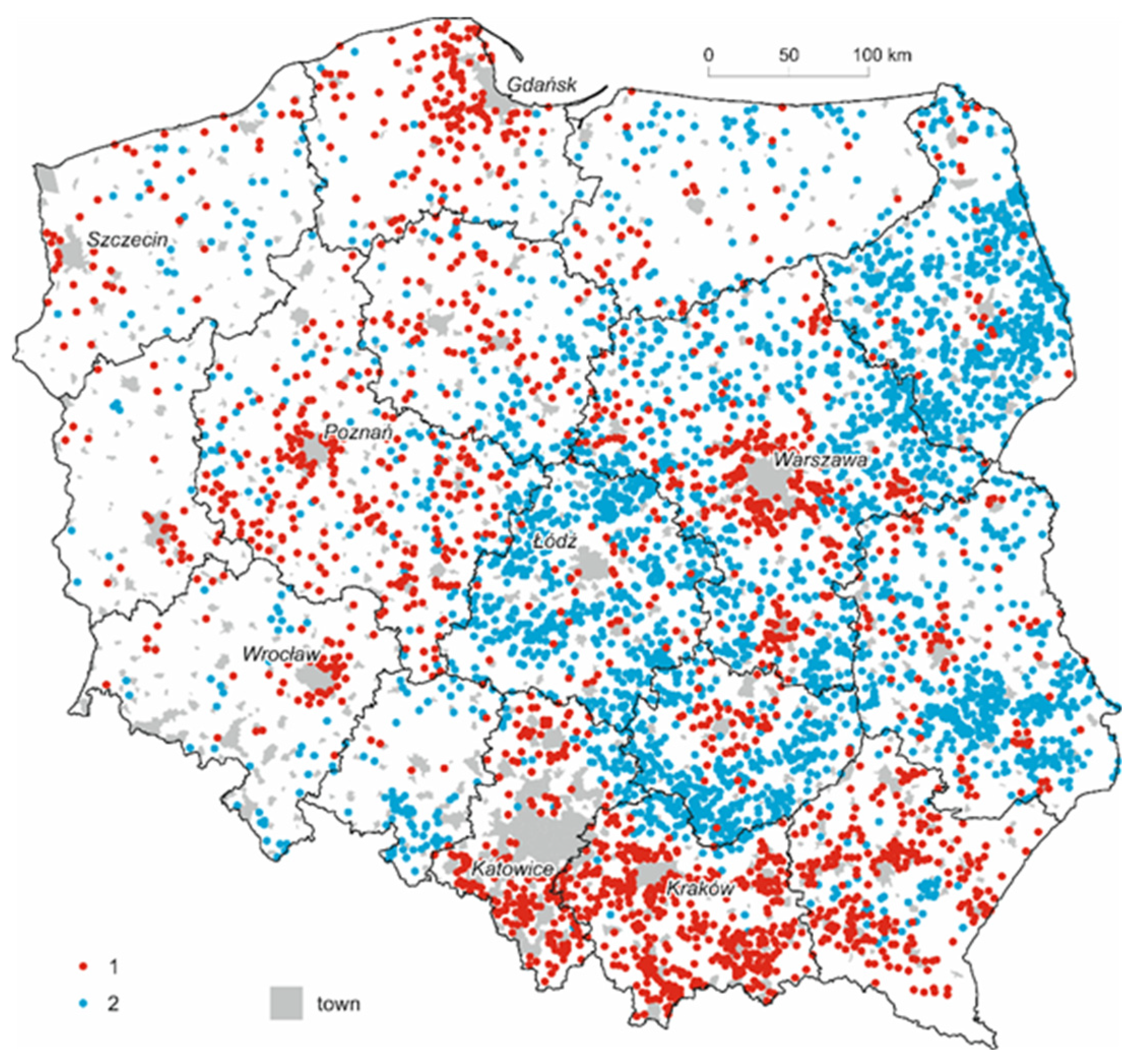
In comparison with the fact that the total population of rural areas practically did not change in the period examined, the above data show that there was a clear evolution of the spatial distribution of population and, consequently, the rural settlement network. However, this evolution is sharply regionally differentiated: regressive villages are concentrated in central and eastern Poland, while progressive villages are concentrated in the south-east and around larger urban centres (Figure 4).
In the following sections, we focus only on two extreme subsets of villages (cf. Table 1): those in which the population fell in all the sub-periods of the census dates—these are disappearing villages—and those with population growth in all sub-periods (progressive villages). We therefore deal with villages with extreme characteristics, which gives us a clearer picture of the mechanisms of change, as well as the socio-economic conditions that cause them.
It is worth noting that the area in south-eastern Poland with numerous villages with a growing population, and at the same time an almost complete absence of villages losing their population, corresponds to the historical boundaries of the Austro-Hungarian partition (cf. Figure 1 and Figure 4). This region is characterised by the presence of large villages and a relatively dense network of local urban centres. Here, a well-established pattern was to combine work (and income) from small farms with work outside of the farm. The non-agricultural income was relatively often related to daily commuting to work in the town or city and to the developing tourist and recreational function using local environmental resources, especially in submontane and mountain areas. At the same time, throughout the post-war period, the population of this region played very little part in migration to towns and cities. In recent years, the region has seen a gradual decline in commercial agriculture, as small farms produce mainly for their own needs or have been completely withdrawing from agriculture. However, the land does not go on the market; the hunger for land, which has continued over a long period, has given it a special emotional value and it is treated as a capital investment, a good that should be protected within the family as security for difficult times, and not a means of production subject to the laws of the market.
Research on migration indicates that the south-eastern region (including the countryside) has recently become the site of an influx of people of retirement age from urban areas across the country, with these kinds of migrants highlighting the environmental values that they desire [5].
Relatively small changes in the settlement network have taken place in the areas of the former Prussian partition (cf. Figure 1 and Figure 4); some villages in this area have shown an increase in population, but this is related to natural population growth. The region also shows low intensity of migration flows to urban areas. The favourable structure of agricultural holdings formed in the course of the enfranchisement process, as well as the relatively early compulsory schooling of the rural population and the tradition of cooperation within local communities have made the region stand out relatively positively in terms of human and social capital. This is conducive to the long-observed social and economic development of rural areas in a multifunctional direction with the use of local resources, including labour.
In the western and northern lands, there are rural areas with an increasing population (especially in suburban areas) as well as those losing inhabitants (cf. Figure 1 and Figure 4). The population is decreasing in the eastern part of the Opolskie Voivodeship, inhabited mainly by the Opole Silesians with dual Polish and German citizenship. They show a pronounced tendency to migrate to Germany for temporary work, which over time turns into permanent emigration. The population is also decreasing in the areas of the high share of former state farms (PGR), which after the war were a way of enabling relatively rapid development of post-German lands, but which in the 1990s underwent restructuring combined with privatisation. It turned out that there were high levels of over-employment in the state farms and slightly more than half the employees of the former state farms found employment in farms that were then established in their place. The resulting unemployment was a difficult social problem due to low qualifications and unfavourable age structure of the unemployed. However, some of them, especially the children of the former state farm workers, tended to migrate, mainly to nearby towns.
The deepest changes in the structures of the settlement network occur in the areas of the former Russian partition. Figure 4 reveals that the largest concentrations of villages with long-term falling populations are in the eastern borderland, especially in its northern part, and in areas in the urban peripheries. The villages with an increasing population are mainly those in the immediate vicinity of urban centres, especially large and medium-sized ones.
In central and eastern Poland, i.e., the former Russian partition area, there was a relatively underdeveloped urban network. This was partly connected with the repression by the Russian authorities, which after the 1863 uprising deprived some of the towns and cities of their status and thus deprived them of a number of developmental privileges. After the war, the region was also characterised by a lagging infrastructure (especially road and related transport), a lower level of education of the rural population, a relative lack of cooperation skills, as well as a very heavy domination of agriculture in the economy of many subregions. Before World War II, the supply both of the means of production for farms and the remaining goods for the population, as well as the purchase of agricultural production, small production for local needs and services for the inhabitants, was to a large extent in the hands of the Jewish population, who traditionally did not work in agriculture [72]. These areas were part of what was known as the Pale of Settlement—a zone the Jewish population of Russia had been forcibly resettled to. After the war, as a result of the Holocaust, the non-agricultural sphere of economy needed to be reconstructed, which in the new conditions of the “planned economy” was slow and did not create a significant local non-agricultural labour market.
Under these conditions, two mechanisms affecting the evolution of the rural settlement network emerged, one of which covered the entire country, but was relatively weaker, while the other occurred mainly in central and eastern Poland, but was relatively intensive and led to significant changes in the spatial distribution of the country’s rural population. The former consisted of a gradual shift of the population living in peripheral villages towards central villages, which are the seat of local authorities, most institutions providing public services, and companies that create the local non-agricultural labour market. Over time, some of these kinds of villages obtained administrative status. For example, in 2016–2020, this status was granted to 25 towns that had previously been villages where the municipality office was located.
The Polish administrative division allows for communes to consist of the villages themselves (rural communes), as well as a town and a few (several) villages (urban-rural communes). Moreover, there are cases where a commune has a rural character but the seat of its authorities is in a nearby town constituting a separate commune. If we take into account only the villages that are the seat of local authorities, from 1950 to 2011, 60.3% of them showed population increase, for 6.4% the change in population was within ±5%, so it can be considered that it did not change, and in 33.3% the population fell. Thus, there were twice as many villages with an increasing population as there were with a falling population. However, if we take into account gminas with increasing and decreasing populations in each census sub-period, there are four times as many of the former than of the latter (18.1% and 4.6%).
The second mechanism of changes in the settlement network, which is especially characteristic of the former Russian partition, is the migration of young people from peripheral regional villages to towns or cities or to rural areas within easy daily access to an urban area. However, this migration stream was accompanied by another—from urban centres to suburban villages. Around large and medium-sized towns and cities, prestigious residential estates are often being built for well-off people, who move to the countryside in search of better living conditions, including environmental conditions. These include people who are freelancers and are professionally successful: lawyers, doctors, journalists, scientists, artists, etc.
Both migration streams, from the village and from the urban area, are characterised by different forms of selectivity. Young, relatively well-educated, and enterprising people leave the village. Most of them are at the age of starting their own families, but sometimes young couples with small children also migrate. Villages from which this type of outflow takes place tend to have an ageing population, a lack of young women (who predominate over men among migrants), a decreasing population, and with time even the disappearance of entire towns [6]. On the other hand, the age structure of the population in places with an inflow of this stream is improving. As a result, the suburban areas and towns are receiving young people, who stand out in terms of education in the outflow environment, but do not stand out positively in terms of education in the inflow environment.
The migration flow from urban centres to suburban villages, or rather to villages that are turning into housing estates or dormitory areas for the urban labour force, is largely composed of people of the age at which they have achieved their position and professional stability. It can be said that this phenomenon means that large towns and cities are overflowing their borders, the social and economic structure of villages directly adjacent to them indicates that they are losing their rural character and functionally becoming part of a neighbouring urban area.
4.3. Economic and Social Factors Influencing the Evolution of the Rural Settlement Network
As already mentioned, agriculture, which in the past was the main economic activity in rural areas, and which provided livelihoods for the majority of the rural population, underwent very significant changes in the period we are dealing with. In fact, this applied not only to agriculture, but also to industry in highly developed countries. Both of these sectors were at a stage of development where a further increase in the value of their production took place without any increase in employment, but in some countries even occurred with a reduction. At present, even in countries that are global giants in the supply of agricultural products, such as Australia, Canada, the US, Germany, or France, agriculture employs about 1% to 4% of the total workforce, and their numbers and proportion in employment are falling. In Poland, about 10% of the national labour resources are employed in agriculture, while the demand for agricultural labour is also decreasing. The key problem for the development of rural areas is related to the lack of development (or in local arrangements) of non-agricultural workplaces there (which results in pressure on the system of non-remunerated income and migrations to urban and suburban zones). This means that the importance of agriculture as a source of livelihood for the rural population is falling, and the need arises either to find other sources of livelihoods, or this process becomes a stimulus for emigration to areas where these can be found.
At the same time, the development of rural infrastructure, technical opportunities to participate in culture, the penetration of urban cultural patterns into the countryside, among other things through television and the increase in spatial mobility, access to education, etc., reduces the traditional gap in living conditions between the countryside and the town. While several decades ago the migration from the countryside to the town was a kind of advance in civilisation, nowadays it is perceived as an increase in opportunities to earn money, develop professionally, satisfy individual aspirations, and take advantage of opportunities provided by developed urban markets, especially the labour market.
The diversification of the social and economic development of rural areas in Poland [2] (Figure 4) reveals that there is a low and very low level of development in the area of the former Russian partition, and also that poorly developed communes can be found in relatively small clusters in the areas annexed by Poland after the Second World War, where a high proportion of the land was used by the state agriculture sector. Several communes of this kind can also be found in the area of the former Austro-Hungarian partition, mainly those whose inhabitants, the Ukrainian population, migrated to the USSR after the war or were subject to resettlement under what was called the Vistula action2.
In the area whole of Poland, but most distinctly in central and eastern parts, the positive influence of the urban neighbourhood on rural development is evident, especially through the vicinity of developed labour markets, especially large and medium ones. Rings of rural areas characterised by a high level of social and economic development have formed around cities such as Warsaw, Łódź, Kielce, Białystok, and Lublin (Figure 5); the areas around suburban areas show a significantly lower level of development in this part of the country. The shape of the suburban areas is influenced by the course of communication routes along which the city’s influence on rural areas extends over greater distances.
The relationship between changes in rural population and the level of development of the local system (gmina) is shown in Table 2, where the level of analysis was limited to rural localities. It turns out that the tendency to expand villages concerns areas that are relatively highly developed in social and economic terms, and to decline where the lag behind. This result is fully consistent with E.G. Ravenstein’s [73] observations on population movements in 19th-century England. According to him, people tend to leave the less developed and therefore less attractive areas, and are drawn to those areas that they believe offer more attractive living and working opportunities. The factor that most strongly influences the decisions on migration from rural areas at the current stage of Poland’s economic development is, it seems, the nature of the labour market. The stream of migrants from underdeveloped rural areas is towards urban areas, whose labour market is larger and highly structurally diverse, or to suburban villages, i.e., areas with lower costs of living and accommodation that urban centres, which, however, allow them to benefit from the proximity of the urban labour market. They leave mainly rural areas which do not offer them non-agricultural jobs, and where staying could mean hidden unemployment on family farms.
This is confirmed by analyses of the non-agricultural labour market in rural areas with the lowest level of socio-economic development. In a number of communes in this category, over 40% of non-agricultural jobs are created by state institutions such as the municipal office, school, health centre, police station, etc. The state is obliged to maintain the local administration and basic institutions providing public services, but if the share of employment in them is not marginal but instead is high, this means that it is almost a monopolist in the labour market. Other non-agricultural jobs in such communes are related to trade, basic services for agriculture and for the rural population, and the creation of new jobs meet resistance from residents, who treat their small homeland as a typically agricultural area and see its values in this. Indirectly, it also means a lack of local demand for products produced by new economic entities and a lack of an opportunity to cooperate with other entities in search of demand outside the immediate surroundings.
At the same time, the majority of villages with a rising population are in communes with a high level of social and economic development. These villages attract migrants from those with lower levels of development.
The socio-economic character of the areas which comprise the majority of villages with a constantly falling population is revealed by the analysis of the typology of communes carried out under the MROW project [2]. It is easy to see that the type defined as the dominance of traditional agriculture is formed by the communes located almost exclusively in the former Russian partition, but they are located on the eastern border and in peripheral areas in relation to the network of large and medium-sized towns. They often occur along the borders of provinces (Figure 6). Moreover, they are characterised by an extremely unfavourable demographic structure and a very high share of agriculture in the local economy. Among the communes of this type, as much as 85% are those in which villages have long been losing their inhabitants. Although communes of this type constitute only 7.3% of the total number, as much as 58% of all the villages in decline are located within their territory. The exceptions are progressive villages, usually located in the vicinity of border crossings or transport junctions, whose impact does not, however, provide a stimulus for the development of the whole commune but ends up only in this village.
The type defined as gminas with a predominantly agricultural function is also notably “indirect” (Figure 6, Table 3). In relation to communes where traditional agriculture predominates, they show many similar but less intense features. Here, too, there is a very high share of family agriculture in the economic structure, formed by migration outflow processes, and an unfavourable demographic structure, although not to the same extent as in the communes where traditional agriculture predominates. The vast majority are also located in the areas of the former Russian partition. They have been described as “indirect” in the sense that they fill the space between peripheral municipalities with predominantly traditional forms of agriculture and areas affected by urban markets. Despite the similar size of both these types of municipality, as much as 58% of the disappearing villages are located within the municipalities of the type defined as those with the domination of traditional agriculture and 25% of the intermediate type. The remaining 17% of such villages are located in the remaining types of gmina, which together constitute 57% of the units examined.
5. Conclusions
The contemporary evolution of the rural settlement network in Poland is a result of two processes. The first is related to the strengthening of the position in the local system of central villages, which are the seat of local governments, institutions providing public services, and most non-agricultural economic entities. These villages are gradually turning into local urban centres, supplementing the relatively poor network of small towns. Through intra-municipal migration, this process is conducive to limiting agrarian overpopulation in the remaining villages, which retain their mainly agricultural character. The effect of this process is also a certain density of the city network.
The second process related to changes in the rural settlement network, overlapping with the first, is regionally limited to the relatively lagging rural area of central and eastern Poland, i.e., the area of the former Russian partition. This consists of highly selective migration from villages to urban or rural suburban areas in terms of age, education, and entrepreneurship. As a result, a number of villages, especially those located peripherally in the commune layout, and often also on the outskirts of voivodeships, sometimes lose their population until whole villages disappear.
In both cases, the main factor causing the evolution of the rural settlement network is the process of decreasing agricultural demand for labour. In the case of intra-municipal migration, its consequence is a polarisation in the local layout of localities into multifunctional and predominantly agricultural functions. As a result of migration from rural areas, the local system reduces the chances of strengthening the multifunctional economy and, together with the reduction of labour demand in agriculture, it reduces local labour resources by preserving the previous economic structure.
The authors’ research showed a picture of the spatial diversity of the rural settlement network as a result of the process of deagrarianisation in the Polish countryside. There is a polarization of local villages into multifunctionally developed rural areas, mainly central villages, local government offices, and those with a predominantly agricultural function. On a supra-local scale, the process of polarization of rural areas to increase suburban population and reduce the peripheral location of large and medium-sized towns is observed. This approach monitors the current social situation in rural areas. A significant share of villages losing population is a feature particularly unfavorable for the functioning of the rural settlement system, while areas with large villages increasing population have high development potential. Therefore, in the opinion of the authors, the presented studies can be used as an instrument of territorial policy, as individual types of rural areas can be assigned, through recommendations, appropriate and optimal actions for a given area concerning various adopted objectives within a specific regional policy. Therefore, commitments and financial resources can be allocated to dedicated areas. In the context of the observed changes, actions should be taken to optimize the development of rural areas, taking into account the reorganization of local settlement network systems.
The presented study on the deagrarianisation of the economic structure and the evolution of the rural settlement network in Poland may help the national government to adopt an appropriate set of policy instruments to counteract the negative effects of this process. Moreover, the presented data concerning a large time frame (1950–2011) can be used for evaluation and comparison in various national studies. As the analysis is limited to rural areas of Poland, it is necessary to continue the proposed studies in other European countries, to compare the changes that are taking place and to determine whether the authors’ observations are universal or specific to a selected group of countries. The issue of Polish specificity is connected with the regional diversity of Poland as a result of the partitions and regional differences in the process.
Author Contributions
Conceptualisation, A.R. and M.W.; methodology, A.R. and M.W.; formal analysis, A.R. and M.W.; investigation, A.R. and M.W.; resources, A.R. and M.W.; writing—original draft preparation, A.R. and M.W.; visualisation, A.R and M.W. All authors have read and agreed to the published version of the manuscript.
Funding
This research received no external funding.
Conflicts of Interest
The authors declare no conflict of interest.
References
- Bański, J. Geografia Polskiej Wsi; Polskie Wydawnictwo Ekonomiczne: Warszawa, Poland, 2006. [Google Scholar]
- Stanny, M.; Rosner, A.; Komorowski, Ł. Monitoring Rozwoju Obszarów Wiejskich. Etap III Struktury Społeczno-Gospodarcze, Ich Przestrzenne Zróżnicowanie i Dynamika; Fundacja Europejski Fundusz Rozwoju Wsi Polskiej, Instytut Rozwoju Wsi i Rolnictwa PAN: Warszawa, Poland, 2018. [Google Scholar]
- Miszczuk, A. Wyludnianie się wsi a Rolnictwo Wschodniej Lubelszczyzny; Dokumentacja Geograficzna IGiPZ PAN: Warszawa, Poland, 1993. [Google Scholar]
- Miszczuk, A. Uwarunkowania Peryferyjności Regionu Przygranicznego; Norbertinum: Lublin, Poland, 2013. [Google Scholar]
- Rosner, A. Zmiany Rozkładu Przestrzennego Zaludnienia Obszarów Wiejskich. Wiejskie Obszary Zmniejszające Zaludnienie i Koncentrujące Ludność Wiejską; IRWiR PAN: Warszawa, Poland, 2012. [Google Scholar]
- Wesołowska, M. Wsie Zanikające w Polsce. Stan, Zmiany, Modele Rozwoju; Wydawnictwo UMCS: Lublin, Poland, 2018. [Google Scholar]
- Stanny, M.; Rosner, A. Rozważania o pojęciu i procesie dezagraryzacji polskiej wsi. Wieś i Rolnictwo 2018, 2, 281–292. [Google Scholar]
- Hebinck, P. De-/re-agrarianisation: Global perspectives. J. Rural Stud. 2018, 61, 227–235. [Google Scholar] [CrossRef]
- Hisano, S.; Akitsu, M.; McGreevy, S.R. Revitalising rurality under the neoliberal transformation of agriculture: Experiences of re-agrarianisation in Japan. J. Rural Stud. 2018, 61, 290–301. [Google Scholar] [CrossRef]
- Hodge, I.; Monk, S. The economic diversity of rural England: Stylised fallacies and uncetain evidence. J. Rural Stud. 2004, 20, 263–272. [Google Scholar] [CrossRef]
- Wilson, G.A. From ‘weak’ to ‘strong’ multifunctionality: Conceptualising farm-level multifunctional transitional pathways. J. Rural Stud. 2008, 24, 367–383. [Google Scholar] [CrossRef]
- Halamska, M.; Śpiewak, R. Rozwój wiejski—Nowa utopia czy konieczność? In Polska Wieś i Rolnictwo w Unii Europejskiej. Dylematy i Kierunki Przemian; Drygas, M., Rosner, A., Eds.; IRWiR PAN: Warszawa, Poland, 2008; pp. 393–416. [Google Scholar]
- Perroux, F. L’Économie du XX Siècle; Presses Universitaires de France: Paris, France, 1964. [Google Scholar]
- Perroux, F. Note sur la nation de pôle de criossance. Ekonomie Appliquée 1955, 7, 93–103. [Google Scholar]
- Hirschman, A.O. The Strategy of Economic Development; Yale University Press: New Haven, CT, USA, 1958. [Google Scholar]
- Myrdal, G. Economic Theory and Underdeveloped Regions; Duckworth: London, UK, 1957. [Google Scholar]
- Findlay, A.; Short, D.; Stockdale, A. The labour market impact of migration to rural areas. Appl. Geogr. 2000, 20, 333–348. [Google Scholar] [CrossRef]
- Stockdale, A. Migration: Pre-requisite for rural economic regeneration? J. Rural Stud. 2006, 22, 354–366. [Google Scholar] [CrossRef]
- Van Der Ploeg, J.D.; Renting, H.; Brunori, G.; Knickel, K.; Mannion, J.; Marsden, T.K.; De Roest, K.; Sevilla-Guzman, E.; Ventura, F. Rural Development: From Practices and Policies towards Theory. Sociol. Rural. 2000, 40, 391–408. [Google Scholar] [CrossRef]
- Francis, T.; Henderson, T. Community Development and Rural Issues; ACRE and CDF: London, UK, 1994. [Google Scholar]
- Kołodziejczak, A. Przestrzenne skutki procesu dezagraryzacji na obszarach wiejskich w Polsce. Biuletyn KPZK PAN 2017, 267, 37–49. [Google Scholar]
- Bański, J. Perspektywy rozwoju polskiej wsi–wybrane zagadnienia. Wieś i Rolnictwo 2014, 4, 1–13. [Google Scholar]
- Stanny, M. Przestrzenne Zróżnicowanie Rozwoju Obszarów Wiejskich w Polsce; IRWiR PAN: Warszawa, Poland, 2013. [Google Scholar]
- Garnet, T. Food sustainability: Problems, perspectives and solutions. Proc. Nutr. Soc. 2013, 72, 29–39. [Google Scholar] [CrossRef] [Green Version]
- Agovino, M.; Cerciello, M.; Gatto, A. Policy efficiency in the field of food sustainability. The adjusted food agriculture and nutrition index. J. Environ. Manag. 2018, 218, 220–233. [Google Scholar] [CrossRef] [PubMed]
- Cattivelli, V.; Rusciano, V. Social Innovation and Food Provisioning during Covid-19: The Case of Urban–Rural Initiatives in the Province of Naples. Sustainability 2020, 12, 4444. [Google Scholar] [CrossRef]
- Phills, J.A.; Deiglmeier, K.; Miller, D.T. Rediscovering social innovation. Stanf. Soc. Innov. Rev. 2008, 6, 34–43. [Google Scholar]
- Rusciano, V.; Civero, G.; Scarpato, D. Social and Ecological High Influential Factors in Community Gardens Innovation: An Empirical Survey in Italy. Sustainability 2020, 12, 4651. [Google Scholar] [CrossRef]
- Coe, A.; Paquet, G.; Roy, J. E-Governance and Smart Communities: A Social Learning Challenge. Soc. Sci. Comput. Rev. 2001, 19, 80–93. [Google Scholar] [CrossRef]
- Lindskog, H. Smart Communities Initiatives; The Information Institute: Washington, DC, USA, 2005; pp. 83–101. Available online: www.heldag.com (accessed on 15 December 2018).
- Harper, R. Inside the Smart Home; Springer: London, UK, 2003; Available online: https://nit.felk.cvut.cz/~dark/ProjektVTymuRizeniProstredi/Clanky/Inside%20the%20Smart%20Home.pdf (accessed on 15 December 2018).
- Kim, M.J.; Cho, M.E.; Chae, H. H: A smart communities for placemaking in housing complexes. J. Asian Archit. Build. Eng. 2014, 13, 539–546. [Google Scholar] [CrossRef] [Green Version]
- Jadhav, A.; Dhavan, G.; Nikole, P.; Ghutukade, M.; Sherkar, V.; Jadhav, A. Case study and planning of smart village. In Proceedings of the International Conference of Recent Trends in Engineering, Science and Management, Pune, India, 9–10 December 2016; pp. 929–938. Available online: http://data.conferenceworld.in/PGMCOE/P929-938.pdf (accessed on 15 December 2018).
- Górka, K.; Łuszczyk, M. Inteligentna specjalizacja czy raczej sektor ”wysokiej szansy” atutem w rozwoju regionów. Studia KPZK PAN 2013, 155, 52–60. [Google Scholar]
- Fleskens, L.; Duarte, F.; Eicher, I. A conceptual framework for the assessment of multiple functions of agro-ecosystems: A case study of Trás-os-Montes olive groves. J. Rural Stud. 2009, 25, 141–155. [Google Scholar] [CrossRef] [Green Version]
- Kłodziński, M. Główne funkcje polskich obszarów wiejskich z uwzględnieniem dezagraryzacji wsi i pozarolniczej działalności gospodarczej. Studia BAS 2010, 4, 9–28. [Google Scholar]
- Kłodziński, M. Bariery wielofunkcyjnego rozwoju obszarów wiejskich. Wieś i Rolnictwo 2012, 2, 40–56. [Google Scholar]
- Wójcik, M.; Dmochowska-Dudek, K.; Jeziorska-Biel, P.; Tobiasz-Lis, P. Understanding strategies for overcoming peripherality: A Polish experience of transition. Biul. Geogr. Socio-Econ. Ser. 2018, 40, 173–192. [Google Scholar] [CrossRef] [Green Version]
- Kutkowska, B. Nowe funkcje obszarów wiejskich na przykładzie terenu sudeckiego. Nierówności Społeczne a Wzrost Gospodarczy 2012, 29, 97–110. [Google Scholar]
- Cocks, M.; Njwambe, A.; Vetter, S. Misread Landscape: The Contribution of Rural Landscapes to People’s Sense of Identity and Belonging. In Proceedings of the Landownership, Governance and Sustainability Colloqium, Hogsback, South Africa, 25–27 October 2017. [Google Scholar]
- Trefry, A.; Parkins, J.R.; Cundill, G. Culture and food security: A case study of homestead food production in South Africa. Food Secur. 2014, 6, 555–565. [Google Scholar] [CrossRef]
- Hebinck, P.; Mtati, N.; Shackleton, C. More than just fields: Reframing deagrarianisation in landscapes and livelihoods. J. Rural Stud. 2018, 61, 323–334. [Google Scholar] [CrossRef]
- Carfi, S.; Bucca, M. The present and future of small farmers in the European Union: Italy’s scenario. Problemy Drobnych Gospodarstw Rolnych 2012, 1, 61–70. [Google Scholar]
- Marsden, T. Economic perspectives. In The Geography of Rural Change; Ilbery, B., Ed.; Longman: Harlow, UK, 1998; pp. 13–30. [Google Scholar]
- Duffy, M. The clock is ticking for rural America. In Sustainable Land Managment, Strategies to Cope with Marginalisation of Agriculture; Brouwer, F., Ed.; Edewrd Elgar: Cheltenham, UK, 2008; pp. 61–79. [Google Scholar]
- Wesołowska, M. Rozwój budownictwa mieszkaniowego a przemiany przestrzenne wsi województwa lubelskiego. Studia Obszarów Wiejskich 2006, 10, 139. [Google Scholar]
- Bijker, R.A.; Haartsen, T.; Strijker, D. Migration to less-popular rural areas in the Netherlands: Exploring the motivations. J. Rural Stud. 2012, 28, 490–498. [Google Scholar] [CrossRef]
- Halfacree, K. Trial by space for a ‘radical rural’: Introducing alternative localities, representations and lives. J. Rural Stud. 2007, 23, 125–141. [Google Scholar] [CrossRef]
- Halfacree, K. To revitalise counterurbanisation research? Recognising an international and fuller picture. Popul. Space Place 2008, 14, 479–495. [Google Scholar] [CrossRef]
- Halfacree, K. Heterolocal Identities? Counter-Urbanisation, Second Homes, and Rural Consumption in the Era of Mobilities. Popul. Space Place 2012, 18, 209–224. [Google Scholar] [CrossRef]
- Smith, D.P.; King, R. Editorial Introduction: Re-Making Migration Theory. Popul. Space Place 2012, 18, 127–133. [Google Scholar] [CrossRef]
- Deller, S.C.; Tsai, T.; Marcouiller, D.W.; English, D.B.K. The Role of Amenities and Quality of Life in Rural Economic Growth. Am. J. Agric. Econ. 2001, 83, 352–365. [Google Scholar] [CrossRef]
- Gkartzios, M.; Scott, M. Residential Mobilities and House Building in Rural Ireland: Evidence from Three Case Studies. Sociol. Rural. 2009, 50, 64–84. [Google Scholar] [CrossRef]
- Halamska, M. Zróżnicowanie społeczne ”wiejskiej Europy”. Wieś i Rolnictwo 2015, 4, 47–66. [Google Scholar]
- Halamska, M. The evolution of family farms in Poland: Present time and the weight of the past. East. Eur. Countrys. 2016, 22, 27–51. [Google Scholar] [CrossRef] [Green Version]
- Czudec, A. Ekonomiczne Uwarunkowania Rolnictwa Wielofunkcyjnego. Prace Naukowe Wydziału Ekonomii Uniwersytetu Rzeszowskiego Monografie i Opracowania 2009, 6, 191. [Google Scholar]
- Wilkin, J. Multifunctionality of agriculture—Theoretical and practical problem. In Selected Considerations of the Agricultural Policy; Ministry of Agriculture and Rural Development: Warsaw, Poland, 2010; pp. 45–48. [Google Scholar]
- Stasiak, A. Przyszłość wsi polskiej—Wieś wielofunkcyjna. In Fundusze Unijne a Rozwój Gospodarki Polskiej (Ze Szczególnym Uwzględnieniem Rolnictwa); Sikorski, J., Ed.; Wydawnictwo Uniwersytetu Białostockiego: Białystok, Poland, 2005; pp. 254–267. [Google Scholar]
- Heffner, K. Directions of Changes in the Development of Polish Rural Areas—Entering into European Rural Space. Studia Regionalia 2014, 39, 10–31. [Google Scholar]
- Heffner, K. Rural Labour Markets and Peripherization Processes in Poland. In Rural Areas between Regional Needs and Global Challenges; Transformation in Rural Space; Leimgruber, W., Chang-yi, D.C., Eds.; Springer Nature: Cham, Switzerland, 2018; pp. 53–71. [Google Scholar]
- Jones, G.; Leimgruber, W.; Nel, E. (Eds.) Issues in Geographical Marginality. General and Theoretical Aspect; Rhodes University: Grahamstown, South Africa, 2007. [Google Scholar]
- Danson, M.; De Souza, P. (Eds.) Regional Development in Northern Europe. Peripherality, Marginality and Border Issues; Routledge: London, UK, 2012; pp. 49–64. [Google Scholar]
- Máliková, L. Theoretical and methodological aspects of identifying marginal rural areas in the Slovak and Czech studies. Zborník Príspevkov Medzinárodnej Konferencie Doktorandov Mendelnet 2013, 2013, 459–464. [Google Scholar]
- Kühn, M. Peripheralization: Theoretical Concepts Explaining Socio-Spatial Inequalities. Eur. Plan. Stud. 2014. [Google Scholar] [CrossRef]
- Collantes, F.; Pinilla, V. Peaceful Surrender: The Depopulation of Rural Spain in the Twentieth Century; Cambridge Scholars Publishing: Newcastle-upon-Tyne, UK, 2011. [Google Scholar]
- Pinilla, V.; Ayuda, M.I.; Sáez, L.A. Rural Depopulation and the Migration Turnaround in Mediterranean Western Europe: A Case Study of Aragon. J. Rural Community Dev. 2008, 3, 1–22. [Google Scholar]
- Rizzo, A. Declining, transition and slow rural territories in southern Italy Characterizing the intra-rural divides. Eur. Plan. Stud. 2016, 24, 231–253. [Google Scholar] [CrossRef]
- Diday, E. Une nouvelle méthode en classification automatique et reconnaissance des formes la méthode des nuées dynamiques. Revue de Statistique Appliquée 1971, 19, 19–33. [Google Scholar]
- Eberhardt, P. Rozmieszczenie i Dynamika Ludności Wiejskiej w Europie Środkowo-Wschodniej w XX Wieku; Zeszyty IGiPZ PAN: Warszawa, Poland, 1991. [Google Scholar]
- Gawryszewski, A. Ludność Polski w XX w.; IGiPZ PAN: Warszawa, Poland, 2005. [Google Scholar]
- Stasiak, A. (Ed.) Migracje ze wsi do miast ze szczególnym uwzględnieniem lat 1979–1985. Studia KPZK PAN 1990, 96, 178. [Google Scholar]
- Bałaban, M. Historia i Literatura Żydowska ze Szczególnym Uwzględnieniem Historii Żydów w Polsce dla klas Wyższych Szkół Średnich, od Najdawniejszych Czasów do Upadku Świata Starożytnego; Wydawnictwa Artystyczne i Filmowe: Warszawa, Poland, 1982; Volumes 1–3. [Google Scholar]
- Ravenstein, E.G. The Laws of Migration. J. Stat. Soc. Lond. 1885, 48, 167–235. [Google Scholar] [CrossRef]
| 1 | Municipal rights in Poland are based on the economic role a given urban center plays in the local community, not on its population. The city rights in Poland are based on the economic role that a given city center plays in the local community, not on the number of inhabitants. The division into rural and urban areas is an administrative decision made by central authorities. It is a criterion specific to Poland. The term “peripheral village” is used in the text, which does not refer to the physical distance from an urban center, but to its accessibility and economic relations with a given village. |
| 2 | A military action against Ukrainian partisans, consisting of the resettlement of the Ukrainian national minority so that they did not form dense clusters anywhere in the country. |
Figure 1.
Course of historical borders in the current area of the country. Source: Own study. 1—an illustrative border of division into three Russian, Prussian, and Austro-Hungarian partitions before World War I against the background of the current Polish territory. 2—an illustrative Polish-German border from the interwar period against the background of the current division of Polish territory.

Figure 2.
Average size of a village in the commune in 2018. Source: Own study based on BDL GUS data.
Figure 2.
Average size of a village in the commune in 2018. Source: Own study based on BDL GUS data.

Figure 3.
Rural population density (population/km2) (2018). Source: Own study based on BDL GUS data.
Figure 3.
Rural population density (population/km2) (2018). Source: Own study based on BDL GUS data.

Figure 4.
Villages with a homogeneous population change direction in all sub-periods, progressive (1) and regressive (2). Source: Own study based on CSO data.
Figure 4.
Villages with a homogeneous population change direction in all sub-periods, progressive (1) and regressive (2). Source: Own study based on CSO data.

Figure 5.
Level of social and economic development of rural areas in Poland. Source: Copyright by MROW 2018 [2]. Classes: 1—very low, 2—low, 3—average, 4—high, 5—very high.
Figure 5.
Level of social and economic development of rural areas in Poland. Source: Copyright by MROW 2018 [2]. Classes: 1—very low, 2—low, 3—average, 4—high, 5—very high.

Figure 6.
Village types according to the structure of socio-economic development components. Source: Copyright by MROW 2018 [2]. 1—domination of traditional agriculture, 2—domination of large-area agriculture, 3—predominance of agricultural function, intermediate, 4—multifunctional, fragmented agriculture, 5—multifunctional, balance of sectors, 6—urbanised, reduction of the agricultural function, 7—strongly urbanised.


Table 1.
Classification of villages by the nature of population changes.
| Type of Changes in the Number of Inhabitants of a Rural Settlement | Size | % of Total Villages |
|---|---|---|
| Deteriorating villages (falling population in all sub-periods) | 2956 | 7.1 |
| Falling-population villages, but not in all sub-periods | 21,054 | 50.8 |
| Villages with a stable population (±5%) | 3322 | 8.0 |
| Rising-population villages, but not in all sub-periods | 12,176 | 29.4 |
| Progressive villages (increasing population in all sub-periods) | 1958 | 4.8 |
Source: Own study based on CSO data.
Table 2.
Gminas with disappearing villages and progressive villages according to the level of socio-economic development.
Table 2.
Gminas with disappearing villages and progressive villages according to the level of socio-economic development.
| Level of Social and Economic Development of the Commune (MROW) | Number of Communes | Of That: Number of Municipalities with Disappearing Villages | Of That: Number of Municipalities with Continuously Progressive Villages | Number of Villages Disappearing in These Communes | Number of Villages Continuously Increasing in These Communes |
|---|---|---|---|---|---|
| 1 | 436 | 362 | 57 | 1518 | 66 |
| 2 | 435 | 273 | 125 | 743 | 174 |
| 3 | 434 | 178 | 188 | 374 | 343 |
| 4 | 434 | 133 | 239 | 245 | 528 |
| 5 | 433 | 51 | 304 | 76 | 841 |
Source: Own study based on CSO data.
Table 3.
Gminas with disappearing and progressive villages by type of socio-economic structure.
| Type of Municipality (MROW) s | Number of Municipalities | Of That: Number of Municipalities with Disappearing Villages | Of That: Number of Municipalities with Continuously Progressive Villages | Number of Villages Disappearing in These Communes | Number of Villages Continuously Increasing in These Communes |
|---|---|---|---|---|---|
| 1 | 474 | 405 | 64 | 1719 | 72 |
| 2 | 380 | 172 | 102 | 244 | 134 |
| 3 | 449 | 280 | 173 | 750 | 259 |
| 4 | 161 | 18 | 132 | 25 | 419 |
| 5 | 433 | 232 | 104 | 165 | 455 |
| 6 | 227 | 30 | 166 | 49 | 453 |
| 7 | 48 | 2 | 44 | 4 | 160 |
Source: Own study. 1—domination of traditional agriculture, 2—domination of large-scale agriculture, 3—predominance of agricultural function, intermediate, 4—multifunctional, fragmented agriculture, 5—multifunctional, balance of sectors, 6—urbanised, reduction of agricultural function, 7—strongly urbanised.
Publisher’s Note: MDPI stays neutral with regard to jurisdictional claims in published maps and institutional affiliations. |
© 2020 by the authors. Licensee MDPI, Basel, Switzerland. This article is an open access article distributed under the terms and conditions of the Creative Commons Attribution (CC BY) license (http://creativecommons.org/licenses/by/4.0/).
Share and Cite
MDPI and ACS Style
Rosner, A.; Wesołowska, M. Deagrarianisation of the Economic Structure and the Evolution of Rural Settlement Patterns in Poland. Land 2020, 9, 523. https://doi.org/10.3390/land9120523
AMA Style
Rosner A, Wesołowska M. Deagrarianisation of the Economic Structure and the Evolution of Rural Settlement Patterns in Poland. Land. 2020; 9(12):523. https://doi.org/10.3390/land9120523
Chicago/Turabian StyleRosner, Andrzej, and Monika Wesołowska. 2020. "Deagrarianisation of the Economic Structure and the Evolution of Rural Settlement Patterns in Poland" Land 9, no. 12: 523. https://doi.org/10.3390/land9120523
Note that from the first issue of 2016, this journal uses article numbers instead of page numbers. See further details here.