Park, Fish, Salt and Marshes: Participatory Mapping and Design in a Watery Uncommons


1
Landscape Architecture, Department of Human Ecology, University of California, Davis (UC Davis), Davis, CA 95616, USA
2
Geography Graduate Group, Department of Human Ecology, University of California, Davis (UC Davis), Davis, CA 95616, USA
3
Horticulture and Landscape Architecture, Purdue University, West Lafayette, IN 47907-2010, USA
*
Author to whom correspondence should be addressed.
Land 2020, 9(11), 454; https://doi.org/10.3390/land9110454
Submission received: 2 October 2020
/
Revised: 14 November 2020
/
Accepted: 15 November 2020
/
Published: 17 November 2020
(This article belongs to the Special Issue Parks and Protected Areas: Mobilizing Knowledge for Effective Decision-Making)
Abstract
:The Franks Tract State Recreation Area (Franks Tract) is an example of a complex contemporary park mired in ecological and socio-political contestation of what it is and should be. Located in the Sacramento-San Joaquin Delta, it is a central hub in California’s immense and contentious water infrastructure; an accidental shallow lake on subsided land due to unrepaired levee breaks; a novel ecosystem full of ‘invasive’ species; a world-class bass fishing area; and a water transportation corridor. Franks Tract is an example of an uncommons: a place where multiple realities (or ontologies) exist, negotiate and co-create one another. As a case study, this article focuses on a planning effort to simultaneously improve water quality, recreation and ecology in Franks Tract through a state-led project. The article examines the iterative application of participatory mapping and web-based public surveys within a broader, mixed method co-design process involving state agencies, local residents, regional stakeholders, consultant experts and publics. We focus on what was learned in this process by all involved, and what might be transferable in the methods. We conclude that reciprocal iterative change among stakeholders and designers was demonstrated across the surveys, based on shifts in stakeholder preferences as achieved through iterative revision of design concepts that better addressed a broad range of stakeholder values and concerns. Within this reconciliation, the uncommons was retained, rather than suppressed.
1. Introduction
1.1. Background
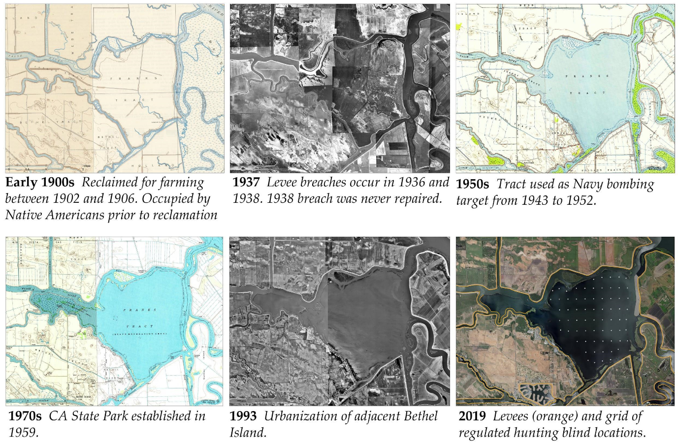
The Franks Tract State Recreation Area occupies two flooded areas of formerly reclaimed land, Franks Tract (3000 acres flooded since 1938) and Little Franks Tract (330 acres flooded since 1982), hereafter collectively referred to as Franks Tract, located in the Western Sacramento-San-Joaquin Delta of California (Delta) (Figure 1). These shallow, tidal lakes-novel to the Delta-were created after multiple levee failures, after which they were abandoned. They have since evolved into a major water recreation and navigation hub for the entire Delta. The tidal lake has also become the home of expanding numbers of aquatic introduced weeds that blanket its surface and fill the water column, making navigation difficult and deeply affecting local ecology. Franks Tract is dominated by predatory introduced species that thrive in these altered conditions, such as black bass, which support economically significant tournaments, but reduce the habitat value for critically endangered species such as Delta smelt and Chinook salmon. As some have claimed, Franks Tract is more akin to a lake in Arkansas and its associated fish species, than a California Deltaic environment [1]. There are fishing tournaments year-round here. During March, April and May, there is a tournament every weekend, the largest of which can generate a half a million dollars in economic activity [2].
Franks Tract is also a problematic source of salinity intrusion into the western Delta from the saltier Bay. In increasingly frequent drought conditions, salinity threatens water supply reliability of regional diverters and contentious Delta exports [3,4]. These exports provide water to the Southern Bay Area, San Joaquin Valley agriculture, and Southern California cities, often at the expense of Delta ecology and local communities [5]. Franks Tract Futures (FTF) is the latest in a string of planning efforts seeking to address water supply reliability issues related to Franks Tract. Tied to water supply reliability are restoration mandates, which are “heavily driven by the detrimental effects of water exports and the reengineering of the Delta as logistical infrastructure for its conveyance” [6]. Restoration mandates across the Delta call for the recreation of tidal marshes, which were 98% eradicated during the diked reclamation of the region in the late 19th to early 20th century [7], along with the eradication of what was left of nomadic to semi-nomadic native American Delta tribes, which had been largely decimated by colonial persecution and European-introduced diseases prior to that time.
Current ecological restoration mandates for Franks Tract are guided by multitudes of scientific and legislative literature. A Delta Renewed [8] is an influential state-funded science-based guide that draws from extensive research on historical ecology [7], landscape change [9] and future scenarios to “discuss where and how to re-establish the dynamic natural processes that can sustain native Delta habitats and wildlife into the future” [8]. The guidelines in A Delta Renewed were specifically applied in initial FTF planning efforts to help set performance goals for conservation, including the size and design of tidal marshes and their dendritic channels.
Unlike previous planning efforts [10,11], the FTF effort has expanded goals of providing enhanced recreational opportunities and community benefits and benefiting native and desirable species by reestablishing lost ecological habitats and processes (The project website: https://franks-tract-futures-ucdavis.hub.arcgis.com/). Thus the FTF effort exists within a dynamic context of interconnected efforts of landscape-scale mitigatory restoration, coordinated adaptation planning on public lands, and a massive and controversial proposed water conveyance project.
Similar conveyance projects, which originated as part of the State Water Project (SWP) and Federal Central Valley Project (CVP) but were never implemented, have been proposed several times. The current project entails a tunnel underneath the Delta that would allow water exports to draw water from the fresher Northern Delta, mitigating issues related to salinity intrusion, water quality and export restrictions related to the endangered species act. Over the course of the FTF project, a new governor took office and downsized the current proposal from two tunnels to one. Yet the project remains contentious, seen by many Delta locals as a water grab, and many FTF stakeholders were skeptical that the Franks Tract project was connected, for example by serving as a repository for tunnel spoils. As noted by Milligan and Kraus-Polk, regarding the Delta’s indeterminate future water infrastructure, “Many plans to alter or sustain these logistical works are uncertain (both in execution, budget, and timeline) and likely to be changed and superseded by new propositions. Given the dominant agency of this planning arena, it renders planning in all others challenging and unpredictable” [6].
We understand Franks Tract as a contested part of the Sacramento-San Joaquin Delta’s far-flung infrastructural landscape, a boating highway, a world-class bass fishery, a novel ecosystem and a chronically underfunded state park. As such, we approach Franks Tract as an uncommons [12,13], meaning there are divergent realities and presuppositions of what the landscape is, all of which exist simultaneously and in relation to one another. Accordingly, our work attempted to engage with the diverse and entangled “ecologies of practice” of this place [14,15].
In practice, we contend that working within an uncommons, of which there are multitudes in the socio-political and ecological crises characterizing the current neo-liberal, late capitalist dominated Anthropocene era, entails accepting that planning and design processes begin and possibly end with a diversity of participant perspectives on what a landscape is and should be [16,17]. This acceptance requires the development and application of methods to “establish a shared understanding of knowledge for action across multiple knowledge domains,” [18] or what is referred to as boundary objects [19,20,21]. Boundary objects are coproduced and adaptable to different viewpoints, but yet are also robust enough to maintain identity across those viewpoints. In co-planning and design contexts the creation of boundary objects can “allow local understanding and interests of participating groups to be reframed in the context of some wider collective activity, which can promote cooperation among stakeholders.” [18] Franks tract, as the spatial milieu of an uncommons, is itself a boundary object. It is a place that is empirically present and aesthetically accessible to all who enter it. Yet it is used, valued and interpreted in radically different ways. To quote from Joan Nassauer, “While we might ‘see’ the landscape through different disciplinary or experiential frameworks, we can point to the same locations or relevant characteristics in a landscape or in a spatial representation of the landscape, and describe what we see there” [10].
In this manuscript, we will present a series of public surveys and co-mapping efforts as landscape boundary objects that facilitated the boundary work of “bridging boundaries between groups of people with differing views of what constitutes reliable or useful knowledge in a co-design process” [18,22] to engender mutual learning and equitable cooperation [23].
Some see Franks Tract as “nature” or “natural.” Some understand Franks Tract, colonized with a fluctuating mix of native and introduced aquatic weeds, as ecologically broken. Those that rely on South Delta exports and diversions perceive Franks Tract as a threat to water supply reliability. For others, Franks Tract is working just fine, and any State-led intervention is unnecessary or malicious meddling: “If it ain’t broke don’t fix it”. These and other ontological differences are part of the ‘politics of nature’ that defines many conservation challenges in the Anthropocene [24] in general and the Anthropocene Delta [25] in particular.
1.2. The Need for Co-Design and Effective Transdisciplinary Practices in Park Planning
Both national and state US park plans have a history of being imposed by outside actors with little to no regard for endemic inhabitants and their co-formative relationships to place, for example, Native Americans [26,27]. While there have been many examples of planners and designers of parks and protected areas considering affected communities, there remain many that have not [28]. There are several motivations driving a recent emphasis on public and stakeholder engagement. However, they can broadly be said to concern issues of social justice and ecological efficacy or some combination thereof, based on the understanding that communities affect and are strongly affected by park management [29]. Research on these social dimensions of parks has focused on collecting, analyzing and utilizing social knowledge. Methodologies include visitor counts, participatory mapping, surveys, interviews and focus groups, text analysis, meta-analyses, scenario planning, structured decision-making [30,31] and co-design.
Co-design broadly refers to designers and people and publics not trained in design, working collaboratively in the design development process [32]. In co-design, the team of participants design with, rather than for those who will use or inhabit the designed landscape, through meaningful and integral stakeholder engagement in the process [33]. We see co-design for parks and protected areas as challenging opportunities to improve upon transdisciplinary processes [34], in that a successful process must integrate and share knowledge from a variety of disciplines (such as engineering, design, social and physical sciences), with the knowledge and values of locals, publics and other stakeholders [35,36].
When properly employed, design research [37,38,39,40,41,42,43,44] can expose differences within the affected communities themselves, and find ways to integrate and design for those differences, especially in complex cultural landscapes with diverse social actors [6,37,38,39]. However, faulty or insufficient research may fail to discern differences [39,40]. False ascription of homogenous non-scientific perspectives, while perhaps convenient, can threaten the trust necessary for transdisciplinary collaboration. Grappling with difference is harder, but necessary for socially just and ecologically efficacious co-design [41].
Planners, designers, and managers have used participation geographic information systems (PPGIS) as one method to give voice to diverse user values in park and conservation planning [42,43]. Brown and Weber describe PPGIS as, “… the practice of GIS and mapping at local levels to produce knowledge of place” [44]. PPGIS was developed to engage and empower user communities, especially marginalized populations [45], and deepen understanding of perceptions, preferences and spatial issues [46]. However, effective public participation can be challenging due to uneven power relations, level of participation, technological access and experience [47,48]. Moreover, as with other participatory methods, PPGIS can be “superficial, obligatory, or token” if no broader, meaningful engagement is encouraged by planning proponents [45]. These challenges persist despite methodological advances, expanded options and greater acceptance by academics, practitioners, and the public [45].
SoftGIS refers to an online PPGIS survey approach developed in response to some of the identified challenges associated with PPGIS, particularly the one-way interaction between communities and planners [49,50,51,52]. The “soft” refers to subjective, qualitative and experiential local knowledge as opposed to the “hard” knowledge of technical professional expertise [49,52]. A rationale for softGIS is that attaching soft knowledge to place by means of a planner-produced map-based survey renders it legible and thus usable in a planning context, where it can be processed alongside other spatial information [49]. For our purposes softGIS had the additional appeal of supporting relatively easy survey set-up and online data visualization. SoftGIS has primarily been deployed in urban planning contexts, however, it is applicable to conservation contexts [53], as well as park planning [49,50], as we will show.
Structured decision making (SDM) is a participatory decision analysis support tool that is considered a conservation social science method [31] and has been used by park planners [54]. SDM relies on clearly articulated objectives, recognition of scientific prediction and uncertainty and the transparent response to societal values to guide decision making [55]. SDM integrates technical information with value-based deliberation and seeks to provide a clearer picture of tradeoffs and uncertainties associated with complex decisions. Most importantly, the SDM approach focuses on reciprocal co-learning and knowledge production for all involved in the project.
The Franks Tract Futures planning effort highlights an innovative application of SoftGIS (in the form of map-based surveys), choreographed into a mixed-methods SDM process to create diverse knowledge for the co-design of a complex and politically fraught park landscape. Our effort proceeded with an awareness of some of the critiques of collaborative and communicative planning related to neglecting power and difference [56]. While we were drawing from established urban SoftGIS approaches, our application was adapted to the parks, public, and infrastructural context of Franks Tract as well as its diverse stakeholders and their varied familiarity with the process. Thus we created survey questions that were widely accessible, and assumed limited project background. While charting a path for collective future action and place remaking, the process and tools also gave representation to ontological differences and ‘uncommon’ understandings of what the park is or could be and applied those differences, rather than suppressing them.
We write as researchers and designers who participated in the Franks Tracts Futures planning effort’s engagement and co-design components. While together we have more than a decade of experience working in the Delta, we began without any significant personal or research-related connection to Franks Tract. When planning and designing with Franks Tract, we recognize that we are engaging a wide array of people, including those who see Franks Tract as central to the way of life and livelihoods. We also sought to engage with, or at least consider potential or prospective users, such as those who might frequent Franks Tract should public access options expand or new recreational features be created. We recognize there is no way of determining this stakeholder population, and thus no way of conducting representative sampling. However, we did assume, based on previous experiences in the Delta, that stakeholders would hold particular sets of interests and many perspectives not held in common about what Franks Tract is, its past and its potential futures.
2. Design Research Methods
In this section, we detail the SoftGIS and other co-design research methods that were applied in the FTF park planning effort. We describe these methods in relation to the process, timing and sequencing of how they were developed and deployed. We feel this is the most effective way to detail the methods, since the FTF case study is useful both in terms of what it did and did not do well (it got off to a difficult start), and to detail how learning and adaptation might occur in transdisciplinary co-design efforts.
2.1. Survey 1: First Feasibility Study
Public engagement for FTF began with an initial Franks Tract feasibility study of a previously developed State plan for Franks Tract. The first survey was conducted from 12 December 2017, through 22 April 2018, after the inadvertent public release of the State plan, and thus captured responses to that design concept. The process was backwards, from a co-design perspective, as the design preceded public and stakeholder output. In developing the survey, we intended for it to provide insights into the demographics and landscape values of a substantial group of people who live, work and play in and around Franks and Little Franks Tracts. (Community perspectives had been gathered as part of a 1985 State Parks planning initiative entitled the Optimum Plan [10]. Prior to that, there were community perspectives gathered as part of the writing of the State Parks general plan for Brannan Island and Franks Tract (which remain co-managed) [57], and as part of a Parks general plan for Brannan Island and Franks Tract (which remain co-managed) [57], and as part of a February 25, 1972, California Senate hearing on Natural Resources and Wildlife [58]. However, little information existed on present-day use). These insights would aid the design refinement of a project that recognized the multiple values of Franks Tract. Thus instead of creative input, we largely received critical feedback on a design concept that only met narrow, state defined criteria, actualized in a manner that was perceived as detrimental to those who live, work and recreate in the area (We attribute the large response numbers, relative to other surveys conducted in the area, to the availability of the early design plan, and the strong response it generated).
The feasibility study recognized its flawed process whereby public engagement came after plan formulation. As part of this recognition, the study highlighted an alternative plan developed by a local resident that was fostered by our outreach and interview efforts. The limited but positive reception of the “locally proposed alternative” indicated the potential for a design that addressed certain local concerns. The study’s recommendations, supported by the Delta Conservation Framework, which was being developed simultaneously, called for early, consistent and transparent public engagement in any future co-design/co-planning process [59].
The feasibility survey was complemented by a series of in person, semi-informal interviews with multiple stakeholders, wherein we were able to ask similar questions, but also had the chance to ask follow-up questions and questions prompted by the online survey. The survey was anonymous and any identifying information that was provided was erased prior to analysis (Data was collected in a Google Sheet that was synced to the live Google Form. The Google Sheet was converted to .csv and .xlsl for analysis in various platforms including Excel, Qualtrics, MaxQDA, Kepler.gl, and R. Each tool allowed for a different view of the data and we found that using one would raise certain questions that would inform our use of the other. After considerable experimentation, we decided to use Qualtrics XM and RStudio 1.1.463 for the majority of the quantitative and qualitative analysis. The geospatial analysis was conducted in Kepler.gl and Excel 2019). Quantitative analysis was conducted using Cross Tabs in Qualtrics and pivot tables in Excel. Self-defined user category was the primary variable used to group responses. Analysis of quantitative variables such as age, length of relation to Franks Tract, and visitation frequency was then conducted within and between groups). See Appendix A. for initial feasibility study survey results.
Our recommendation at the end of the feasibility study stated that the, “community is wary of significant change to the region as well as any top-down decision-making that does not take their interests into account” [60]. And that “local communities are highly interested in being involved in the design and planning process for any potential changes to Franks and Little Franks Tracts” [60]. The study resolved that “more detailed restoration planning will take into account the social, economic, and recreational interests of the affected local communities and user groups” [60]. Reflecting on the conclusion of the feasibility study, we noted that the value of the survey remains contingent on the willingness and ability of facilitators, designers, planners and managers to integrate this information into this next phase of thinking about the coevolution of Franks Tract and the diverse group of people and communities who have a relationship to it.
2.2. Survey 2: User Survey
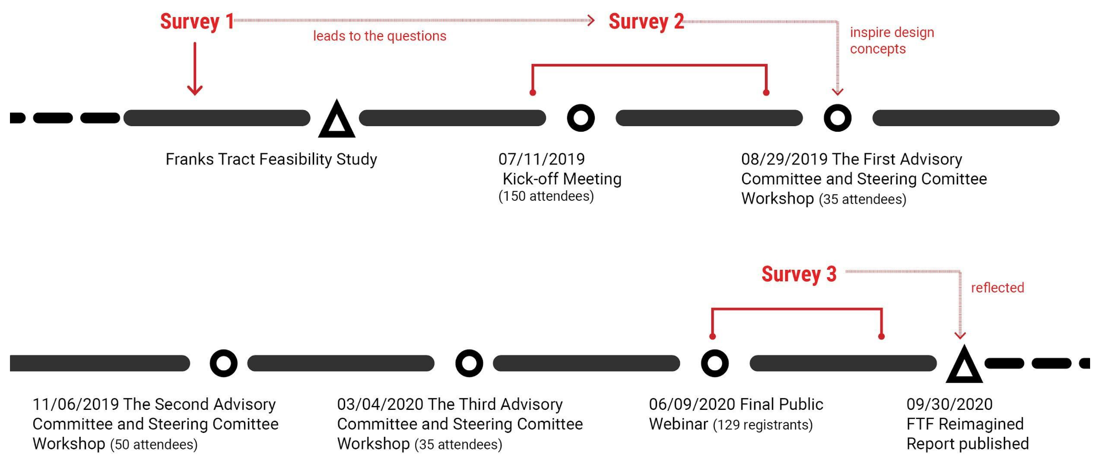
The second survey was part of a follow-up, and highly revised planning effort built upon the lessons learned from the previous efforts (see Figure 2). The survey was conducted from 11 July 2019 through 13 September 2019.
The primary focus of the second FTF planning effort was determining if a multi-value project could be designed to benefit local and regional communities (by addressing concerns raised in the first effort and via the creation of recreational amenities), and to minimize detrimental impacts of the project to these same communities, while still meeting ecological and water quality goals. The FTF engagement process started in June 2019 and ended in September 2020 (For more information see Final Report Appendix A. Public and Stakeholder Engagement: https://ucdavis.box.com/s/hl3qpglcu9ibf919sfby1txeb8qu6unl). The effort began with creating a steering and advisory committee, which participated in regular design charrettes and reviews. At the packed, public kickoff meeting (approximately 150 attendants), the team openly solicited feedback on the objectives of the project, described the structured decision planning process and expressed a commitment to meaningful engagement with the public to co-design the project design concepts.
The project team pursued this design challenge by engaging the public and stakeholders throughout the design process. During the co-design process, a diverse group of experts in different realms were involved in the design development, including engineers, scientists, public agency representatives, boaters, fishers, hunters and local residents and business owners all contributing their own knowledge of the landscape as well as unique, i.e., uncommon, perspectives. The project team used multiple engagement methods, including two map-based surveys and a non-map-based survey, iterative stakeholder-driven research by design, group and individual interviews, and two public meetings, including a webinar necessitated by COVID 19 restrictions on public gatherings.
Structured decision making (SDM) was used as a decision analysis tool to develop and evaluate performance criteria related to these multiple interests and concerns. The SDM approach was also used to guide and integrate technical design and engagement results during planning. Design and engagement results were integrated using a research by design [61] approach in which design concepts were iteratively refined and narrowed down through inclusive rounds of review by participants, including advisory and steering committee members. Refinements occurred primarily during in-person meetings with the steering and advisory committee. Public meetings provided another opportunity for broader public participation. Map-based surveys were the primary platform for public participation in the co-design process. Surveys were conducted at the start and finish of a second planning round, after initial comments from the public kickoff meeting were integrated.
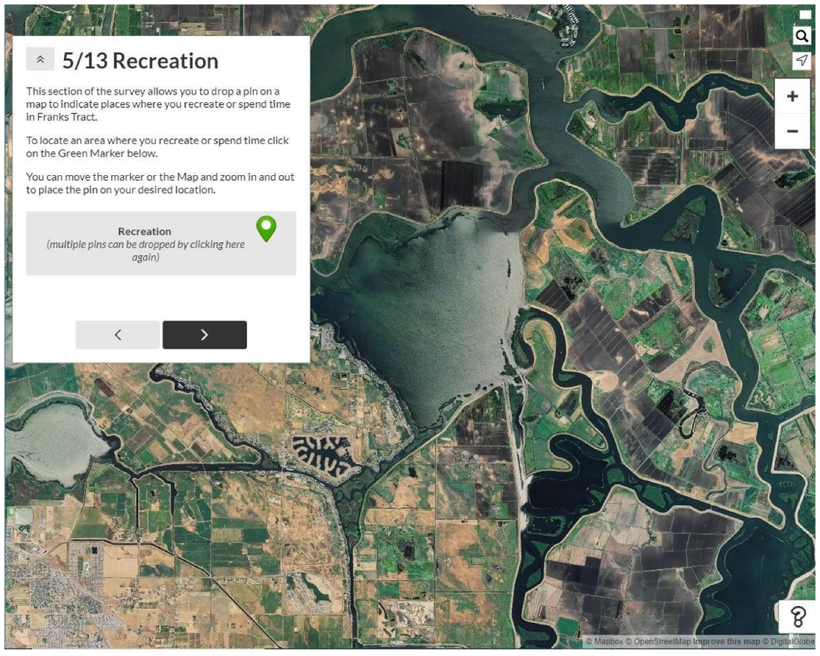
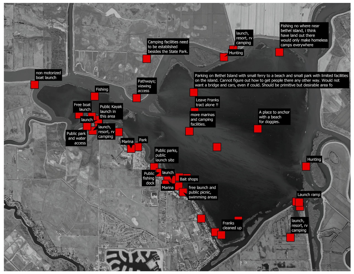
The user survey, launched at the public project kickoff meeting, was intended to collect information on where and how people recreate in Franks Tract and identify areas of Franks Tract that were deemed to need improvement and where tidal marsh might optimally (or least detrimentally) be located within the shallow lake. After extensive research on map-based survey platforms we selected Maptionnaire, “an advanced example of PPGIS methodology enabling the mapping of environmental experiences, daily behaviour practices and localised knowledge and ideas for spatial development” [50]. See Appendix B for a link to the no longer active survey (Quantitative analysis was conducted in google sheets and Excel. Spatial analysis was conducted in ArcGIS Pro 2.6.1). We chose this platform, in part, because it allowed for intensive customization and data transferability across other software platforms, per our specific needs. Asking demographic questions, informed by the previous feasibility survey, enabled an analysis of the relationship between demographic variables, such as age, income, area of residence, user category and perspectives. The maps created from this survey are crowdsourced and user-drawn rather than primarily authored, and composed or decided on by the consultant team (Figure 3). We also asked participants to rank concerns and state their perspective regarding climate change in relation to Franks Tract.
The project team used the information solicited from the second survey to revise design features, which were then presented and discussed in the following design charrettes and later publicly on the project website. During the design charrettes, steering and advisory committee members had another opportunity to modify the designs and ask questions.
2.3. Survey 3: Design Concept Survey
The design concept survey gathered feedback on three design concepts that were developed with input from the previous survey, and the FTF advisory and steering committees. Before taking this survey, we encouraged participants to attend or watch a recording of a live webinar (129 registrants), which presented all the design concepts and how they were developed.
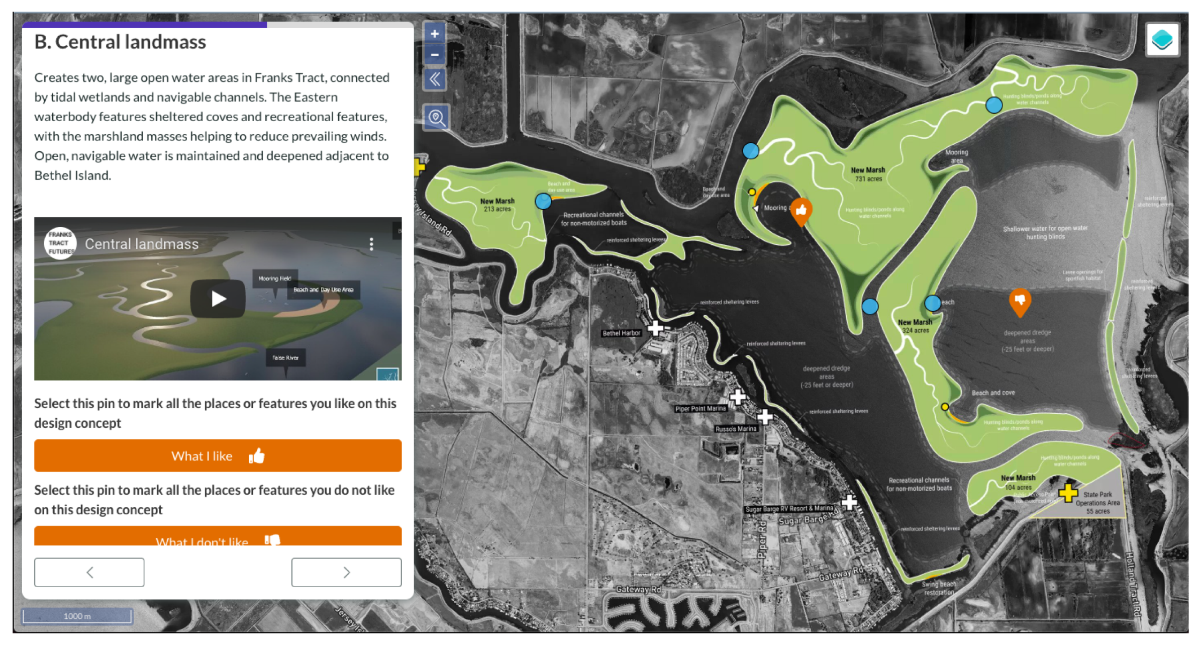
We designed the design concept survey using an updated version of the same Maptionnaire platform for user familiarity. Photographs, rendered images, flyover videos (See Appendix D for links to concept flyover videos), and links to the previous survey results were embedded within the survey to provide project background and give a better sense of the proposed concepts. The survey was designed to allow participants to indicate what they like, didn’t like and ask questions spatially. After placing a like or dislike pin, follow-up questions related to location and access were asked in order to discern the reasons for liking or disliking a feature more clearly. A question pin could also be placed by participants to ask about a specific location or feature (Figure 4). The third survey also contained a final question where participants were asked to rank the design concepts and no action alternative. See Appendix C for a link to the defunct design concept survey. (3D models of the designs were created in Lumion 10 to produce animated flyovers. Detailed still renderings of site features-such as beaches, day use areas and waterfowl hunting ponds, were finessed in Adobe Photoshop CC 2019. Quantitative analysis was conducted in google sheets and Excel. Spatial analysis was conducted in ArcGIS Pro).
3. Results
3.1. Survey 1. Feasibility Survey
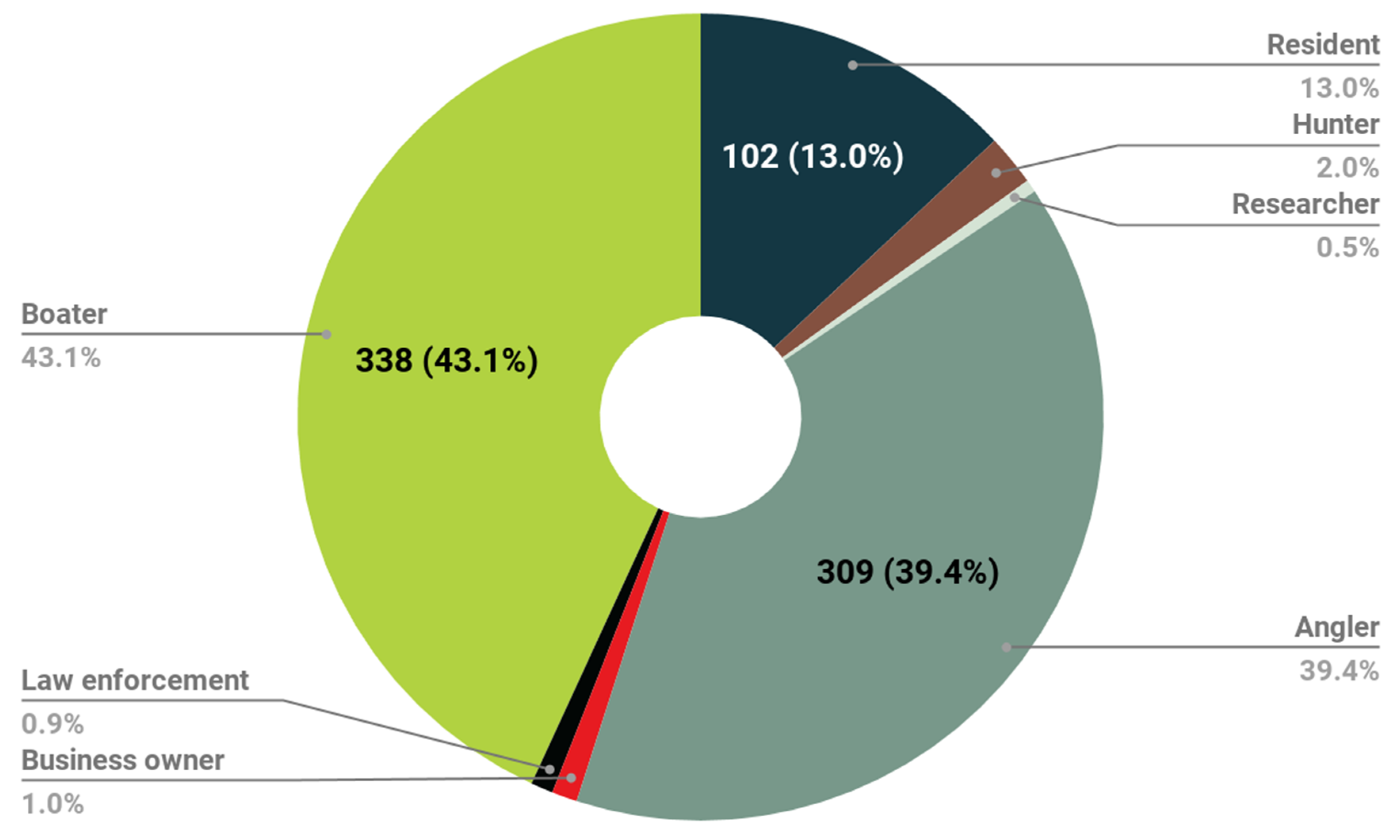
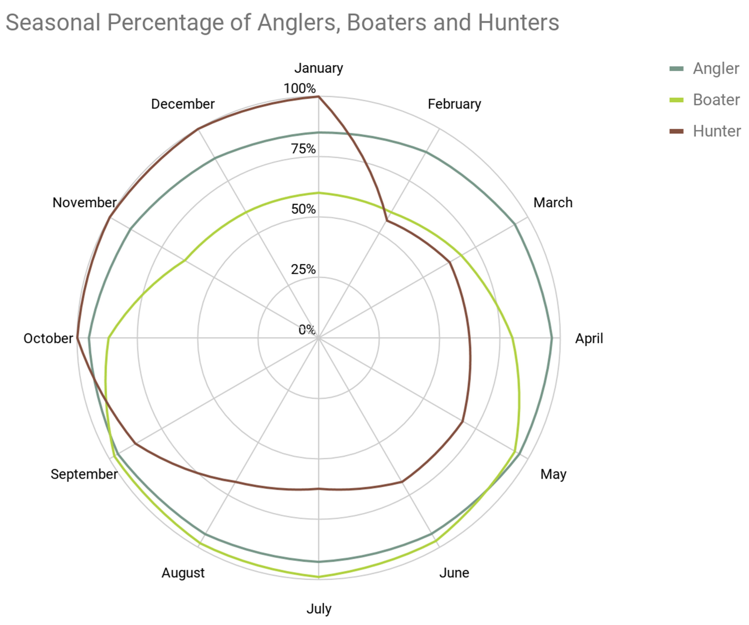
Feasibility survey results provided a picture of participant demographics, the majority of which are older, local and identified as the boater or angler category (Figure 5). The majority of participants provided a local zip code of residence; however, participants were distributed across California as well as adjacent states. The presence of participants on Franks Tract is seasonally influenced and dependent on type of activity and affiliations, but overall is heavily used and recreated in year-round, with activity highest in the summer (Figure 6). Of note, approximately 45% of survey respondents (308 of 728) were firmly against the project, and preferred that Franks Tract be left as it is.
Extensive qualitative survey results captured the strong response to the initial state proposal map (Table 1) and a widespread desire for Franks Tract to be left alone (Table 2). Survey responses were coded inductively for themes and subthemes, although there were similar themes from the previous survey. The subthemes included in Table 1 and Table 2 include major concerns that emerged through other modes of engagement.
3.2. Survey 2. User Survey
User survey results reassessed user demographics and types from the previous survey, and created new knowledge of geospatial use patterns in and around Franks Tract as well as divergent perspectives on Franks Tract’s potential futures. See Table 3 for main geospatial takeaways and associated figures.

Table 3.
Main geospatial takeaways.
| Main Geospatial Takeaways | Figure Number |
|---|---|
| Activities are diverse and occur throughout the Tract. Primary activities are boating and recreational fishing. | Figure 7 |
| The Tract is a major boating hub and includes highly trafficked routes that leave and return from Bethel Island destinations and routes that traverse the Tract to and from locations outside the project bounds | Figure 8 |
| Public access was desired, especially along the shoreline | Figure 9 |
| Respondents indicated that many parts of the Tract need improvement | Figure 10 |
| Tidal marsh preferences appeared to overlap most in the Northeastern portion of the Tract, farthest away from Bethel Island homes and business | Figure 11 |
Figure 11.
If tidal marsh areas are created in Franks Tract, where would they be best located? Where would they have the least detrimental impacts and greatest amenity value (such as new hunting opportunities, wildlife viewing, non-motorized boating, etc.) for how you and others use Franks Tract? How could tidal marsh be designed for recreational uses (I.e., hunting, fishing, kayaking, boating)?

The user survey had roughly the same demographic composition of participants as the feasibility survey. The user survey results related to activities and desires validated those of the feasibility survey and other methods of research and engagement while adding a spatial dimension that could more directly inform concept co-design.
The results from the public access-related questions both indicate (spatially) where public access is desired and allude to a tension between those who support greater public access (51.6%) and those who do not (48.4%). The relationship between distance from Franks Tract of participant’s zip code and their public access perspectives proved statistically insignificant. However, a tension between locals and visitors became evident in later design charrettes, primarily related to the impact of new, free public access on existing businesses on Bethel Island that charge for access.
Results indicate the persistence of concerns related to the site and smell of tidal marsh that were raised in the initial feasibility study. Desired locations tended to be located in the Northeast of Franks Tract furthest away from the waterfront residence and business on Bethel Island, as well as in Little Franks Tract.
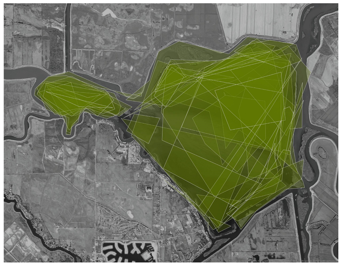
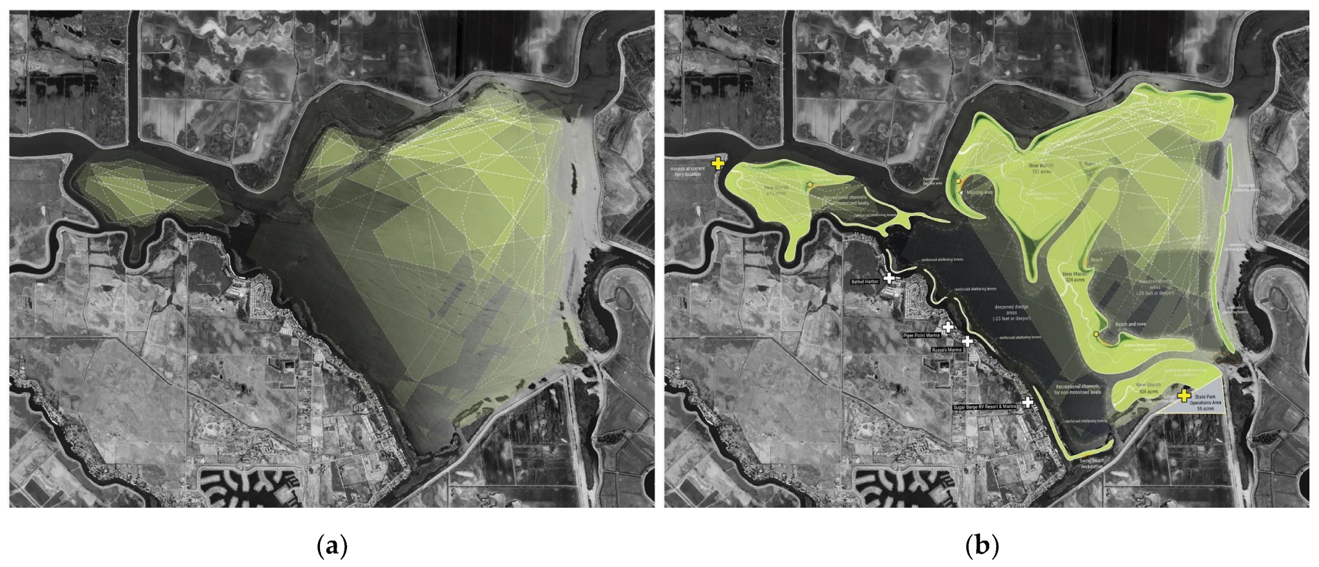
The map-based questions’ results were directly integrated into the iterative concept design process, particularly the siting of public access, the preservation of highly trafficked boating routes, and the general preference for marsh placement in the North and Northeastern portion of Franks Tract. The geospatial data was analyzed in ArcGIS Pro and the preliminary results were presented in the August advisory and steering committee meeting before the design charrette. By overlaying the results on top of each other as semitransparent layers, a strong correlation showed up in terms of improvement areas (Figure 11) and preferred marshland best locations (Figure 12).
The visualizations of the first survey sparked conversation of meeting participants, allowing for more thinking on the pros and cons of proposed marshland configurations. The geospatial result was compared with other sources of spatially explicit knowledge that was co-produced during design charrettes and stakeholder interviews, and was also made available to the public through an online interactive map hosted on the project website. These maps allowed users to explore both the spatial data (points, lines, and polygons) and the associated qualitative data (map-based comments). Sharing the data in this way increased transparency and trust building, which is a critical factor in engendering equitable PPGIS approaches [50].
3.3. Survey 3. Concept Design Survey
Concept design survey results include substantial and detailed consideration (likes and dislikes) of the design concepts. This result alone represents a significant change from the feasibility survey, where nearly all the comments on the plan were negative. Participants still voiced similar concerns as those collected in the feasibility survey. However, there were also new concerns and detailed design questions (such as placement of features, the design of tidal marsh to optimize recreational and ecological benefits) that indicate an investment in a future for Franks Tract other than the continuation of a status quo.
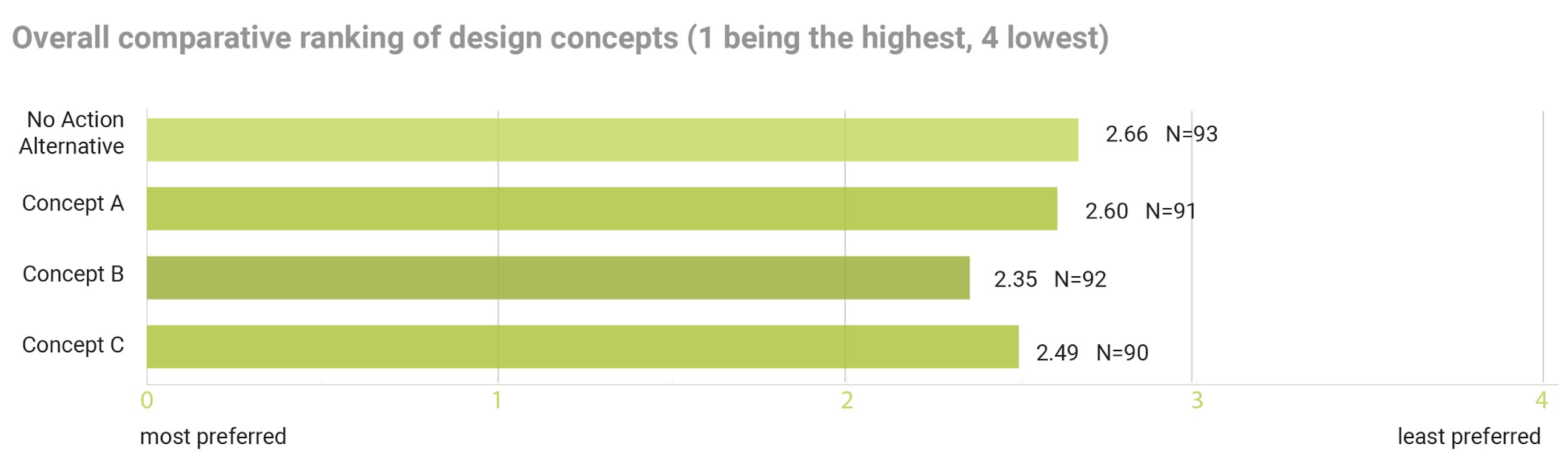
The above figure (Figure 13) represents the average comparative ranking for each concept scenario, with 4 corresponding to the lowest ranking and 1 corresponding to the highest on average the Design Concept B (Central landmass) was the highest ranked (2.35). The NAA (No Action Alternative) was the lowest-ranked (2.66), but only by a small margin with Design Concept A (2.60). (Open water berm and channel) only closely ahead, and Design Concept C (Eastern Landmass) slightly more preferred (2.49).
What is notable in the design concept survey is that there was, on average, similar support across the NAA and the design concepts (Figure 14). Such similarity implies that there was considerably more ‘most preferred’ voting for the design concepts (collectively) than for the NAA. Specifically, although 36 (39%) respondents chose the NAA as their most preferred option over two times as many (75) selected at least one of the three design concepts as their most preferred, suggesting significantly higher preferences overall for the design concepts over a NAA.
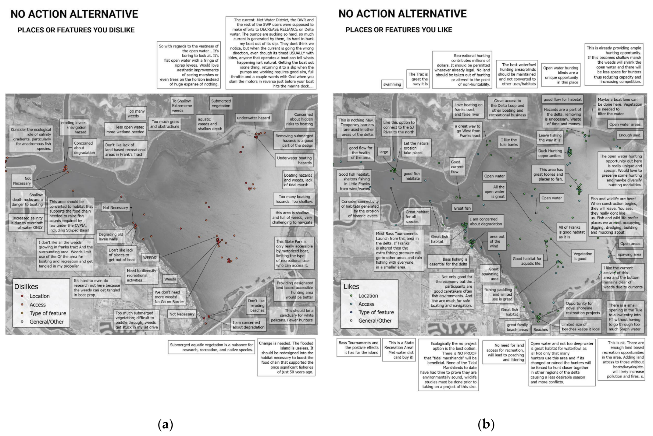
Supportive comments for the NAA focused on unique features such as open water, spawning areas, fishing, hunting, good flows and access. Some respondents were concerned that these features might be lost or diminished if a project were implemented.
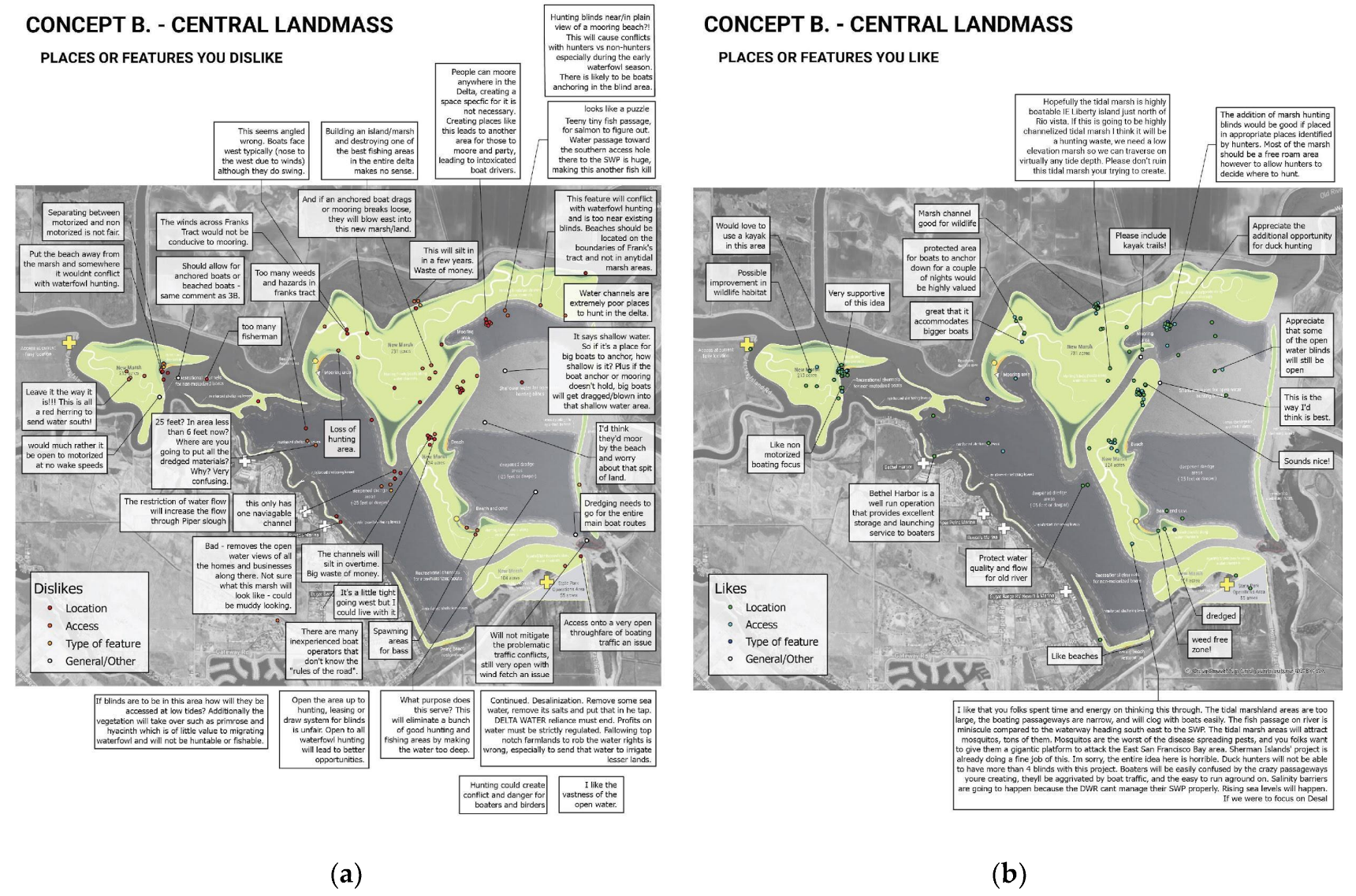
However, there were also supportive comments regarding potential modifications with the design concepts that could enhance these unique existing features, address current concerns and create new opportunities based on improved navigability, additional features and the general diversification of Franks Tract (Figure 15).
Beaches were a common liked feature across the design concepts. However, there were concerns voiced about their proximity to hunting areas and their potential to become too popular and thus an attractive nuisance. There was a recurrent concern voiced regarding the channel widths and navigability in the design concepts. Comments to this effect included potential problems with inexperienced boaters, the narrowness of the channels and the hazard created by adjacent tidal marsh. There were also concerns that channels would silt in.
In general, there was widespread support for the proposed modifications to Little Franks Tract (which were the same across all design concepts). There were concerns raised about the potential exclusion of motorized boats in the area. Some thought this unfair, while others questioned the accessibility of the area for non-motorized boaters. Others were supportive of the idea of a portion of Franks Tract in which motorized boats are excluded.
There were many comments across all concepts related to hunting. Several voiced concerns about the potential eradication of existing hunting opportunities, where others appeared supportive of new marsh-based hunting opportunities, often contingent upon the resolution of access issues, and the inclusion of hunter preferences in the marsh habitat design. There were also concerns about the potential conflict between hunting and other recreational activities, especially where hunting and recreational features might be nearby.
Comments diverged regarding the benefits of creating marshlands and dividing Franks Tract into two separate water bodies (Figure 16). While many supported the idea based on improved navigability, habitat, and recreation, others were concerned about navigation, local businesses, aesthetics and existing recreational opportunities. Participants commented on mosquitoes and the marsh smell, which had come up in previous surveys and elsewhere in the process.
As with the second user survey, geospatial results were shared with the public through an online interactive map hosted on the project website. Ranking results were also included. These results were shared shortly after the release of the final report, and although they were not integrated into the final designs, they are now available to the public and other stakeholders and can be used to inform future design development.
4. Discussion
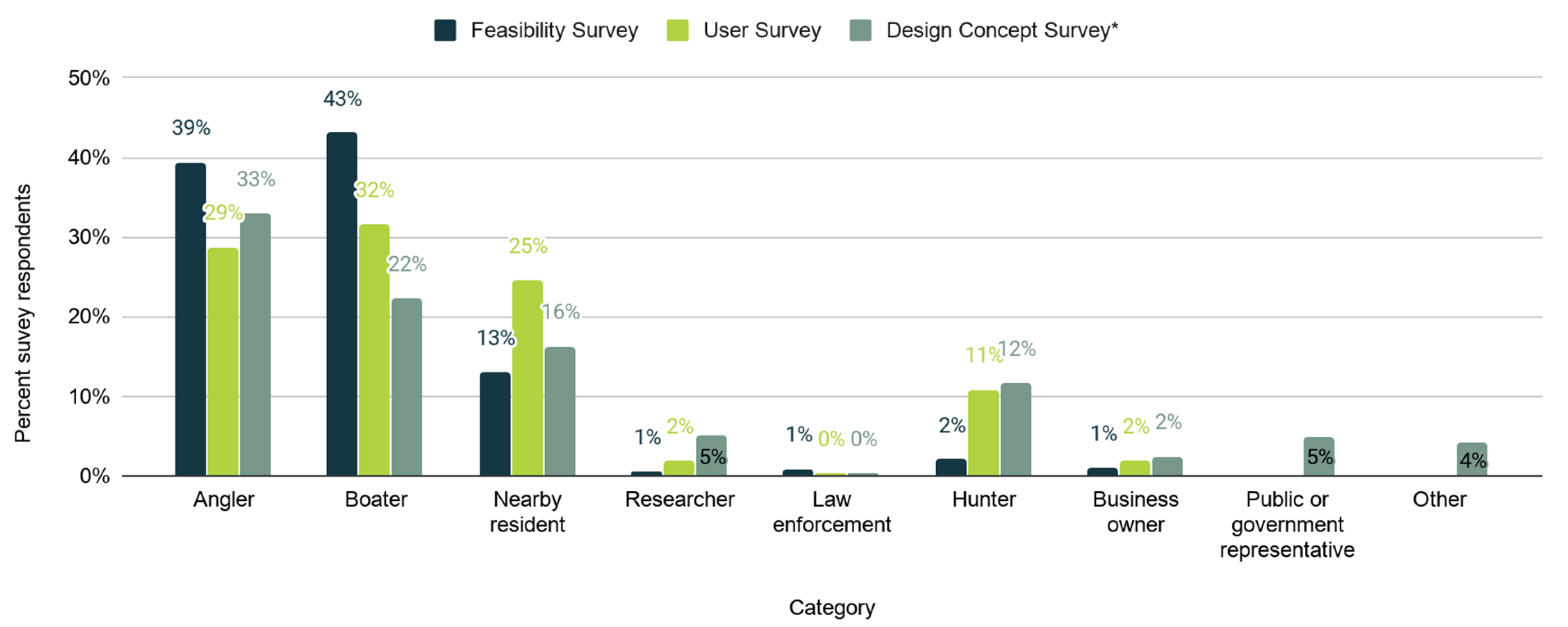
The approximate demographic makeup of survey participants was consistent and similar across all three surveys (Figure 17). The majority of the participants were local, and most participants categorized themselves as boaters or anglers, which we understand to be the most prevalent Tract activities.
These surveys were some of our primary means of co-creating knowledge with a very broad public, and were combined with public and stakeholder meetings, design workshops, social media and other forms of stakeholder engagement. Echoing Kahila-Tani et al., these map-based surveys [50] were an important tool for the deliberative phase of a sensitive and complex planning project. Making the collected data visible allows for and catalyzes collective analysis and debate, during which for all involved, planners and the public alike, assumptions can be questioned, and perceptions can shift.
To our knowledge, no prior survey has been performed targeting those who live, work and play in and around Franks Tract. What little information exists from past surveys indicates that those who responded to our survey are quantitatively distinct from the average Delta recreationalist. Past engagement with Franks Tract users indicates a concern with safety, conservation, and recreation that resonates with the concerns of our survey respondents [10,58]. Our response numbers were substantial compared to other surveys conducted in the region. Whereas past surveys focused on regional boating and recreation [62,63,64], ours were more geographically specific and sought to identify broader use trends as well as perspectives related to landscape change.
We recognize we have no way of knowing whether we surveyed a representative sample of those who live, work or play in Franks Tract currently or may be inclined to do so in the future. We used an aggressive, multi-pronged approach to dissemination that included local and regional canvassing, social and conventional media, duck hunting forums and direct emails to hunting permit holders. Yet based on comments on social media and responses to the draft report, there remained some people who are unaware of the project or its particulars. Additional follow-up approaches to reach these people were not attempted due to time, limited financial resources and COVID-19 restrictions on attempting in-person survey methods.
Given our dissemination approach, we cannot discern a response rate. However, we did see decreasing participation numbers from survey 1 through survey 3. This decrease could be attributed to a variety of factors, including the length of time the surveys were open, which also decreased from survey 1 through survey 3, as well as accessibility associated with the map-based surveys (2,3). We also note the possibility that the decrease in participation could also be attributed to increased acceptance, or at least decreased outrage about the design of the project.
Looking across the sequence of surveys, we can observe a measurable shift in perspective away from a no-action alternative. The first survey unintentionally captured initial reactions to a remarkably unpopular State plan prepared without public input. When asked, “Are there any suggestions you have for the future design and management of Franks Tract/Little Franks Tract?” roughly 45% of participants responded that Franks Tract should be left alone. The second survey was launched at the beginning of a new round of public engagement and co-design. When asked, “What are your other concerns related to Franks Tract?” approximately 40% either expressed concern with a potential project or a desire for Franks Tract to be kept or left as it is. However, this survey also revealed more diversity in user opinions, as revealed when asked how Franks Tract could be improved or modified according to their desires, which resulted in a wide range of suggestions, some common and some not, and dissatisfaction with the status quo. The third survey asked participants to rank three design concepts and the NAA. Results showed nearly equal support across both the design concepts as well as the NAA. Though it is difficult to empirically draw firm conclusions from the surveys regarding increased acceptance of the project’s ecological and water quality goals specifically, comments at project meetings and project presentations with stakeholders, the public and the advisory committee highly support this conclusion as being expressed in the final survey responses. Specific to ecological goals, as these were expanded beyond the state’s initial focus on Delta Smelt to a broader and equal support for additional threatened species (with commercial value) and sport fish, as well as upland species, like waterfowl for hunting, ecological goals gained more acceptance.
While the three surveys empirically showed demonstrable shifts in attitudes and movement towards proactive design interventions for Franks Tract (in contrast to the NAA) what we also consistently read across the surveys was ontological diversity-a plurality of realities and notions of what Franks Tract currently is to various persons and constituencies. Those plural views configured themselves around proposed changes to the landscape. There remains a strongly voiced contingency that rejects any intervention on multiple grounds, ranging from the conspiratorial who see a “water grab”, whereby Delta exporters are seeking to take more water (through the improved water quality the project would provide), to the skeptics who want examples of similar successful projects before they can support a project in the place they love. There remains a contingency that sees Franks Tract as Nature and intervention as hubristic and doomed to fail.
There were certain features that were identified in the user survey and design charrettes that prompted considerable design effort, with input from the advisory committee members and technical support from project team members. One example is a particularly dangerous blind corner located in the Southeast corner of Franks Tract, where multiple navigation routes intersect and wave and wind action are prevalent. The results from the concept design survey indicate recognition of efforts to make this corner safer as well as unresolved issues. We bring this up as an example of the benefits of and need for sustained and iterative co-design as well as the importance of humility. Rather than seeing persistent concern as a failure, we embrace it as an indication of engagement.
There appears to be a growing contingency that sees the FTF project as a way to advance or enhance their interests, or at the least, arrest an undesirable decline. We see in the growth of this contingency evidence of what Seijger et al. refer to as the affective and informal “soft implementation” related to shifting prospects for change that precedes the “hard implementation” of more formal and detailed project plans [65]. If our observation is correct, this in itself would constitute a success based on the objectives and expectations for the planning process.
We feel it is important to emphasize that the learning and knowledge creation involved in this “soft implementation” was in no way exclusive to the public. The placement of the surveys throughout the planning process exemplify different approaches to knowledge mobilization that provide lessons for the project team and the agencies involved. The flaws of the feasibility study were clear in the results of the feasibility survey and provided the impetus for the more participatory approach of the user survey. The design concept survey reaffirmed a commitment to co-design and the results validate its efficacy. Each survey alone would have had limited influence. However, cumulatively the surveys created, mobilized and applied knowledge, in what we hope will continue to be an iterative cycle of reflexive co-design.
In this way, the sequence of surveys informed and contributed to an iterative co-design process. Although the surveys were not the only means of collecting information that informed the design, they were the most inclusive of a broader stakeholder public. Additional information was solicited from an advisory and stakeholder committee and consultation with biologists, recreation consultants, economists, engineers and hydrologic modelers. In line with Brown and others, we recognize these methods of engagement as critical irrespective of the PPGIS [45].
5. Conclusions
In their review of two decades of PPGIS application, Brown et al. argue that “the mapping of place values will need to become more than a spatial technology enhancement to public participation, but a political force that can compete against powerful interests that currently dominate land-use decision processes at multiple levels of government [47].
Our role in the Franks Tract project was to use co-design research methods to inform multi-value project design in a complex and contentious park landscape. We employed softGIS surveys to bridge identified gaps, related primarily to ease of use and accessibility, between many research-oriented PPGIS methodologies and the practices of meaningful participatory planning [51]. SoftGIS supported the iterative creation of relatively inexpensive surveys by members of the planning team as well as the creation of online visualization tools.
The surveys and co-mapping techniques deployed in the FTF project provided tangible, co-generated representations of Franks Tract as a contested boundary object. It did so within a larger, multi-faceted co-design process (that included meetings, design workshops, structured decision making techniques, iterative design development and modeling, etc.) that allowed for the consultant team and all involved to perform the needed work of “bridging boundaries between groups of people with differing views of what constitutes reliable or useful knowledge in a co-design process” [18,22].
Rather than suppress diverse conceptions of what Franks Tract is, ways it is inhabited, and what it may become, we sought to find ways that those realities and virtual desires could co-exist in new design configurations. The map-based surveys were strategically timed within the design process, generating spatially explicit public feedback when it was most influential and usable. These surveys co-created knowledge about what Franks Tract is becoming and could become without design intervention and provided space for more qualitative descriptions of preference and desires, informing and being informed by categorical and spatial responses. This feedback was incorporated with input from advisor and steering committee members and technical experts into a structured decision-making framework. The concept designs that emerged sought to integrate these shared understandings in the form of desired design features.
Yet despite structured decision-making efforts to include these understandings and transparently address conflict and tradeoff, there remains some skepticism of the designs based on different understandings of what the landscape fundamentally is and how it should be used and inhabited. Rather than seeing the persistence of ontological differences or understandings not held in common (i.e., uncommons) as a failure, we recognize their inevitability in such complex and contentious planning processes. Furthermore, we advocate for the inclusion of the uncommons in this and other consensus-building processes, and exploring the degree to which the spatio-physical design of the landscape can embody and facilitate this diversity.
Questions of representation associated with survey sampling remain. Our non-probability sampling methods, which included convenience, purposive and snowball, were required based on our judgment, due to an unknown and sometimes hard to reach population. While our surveys had a diversity of participants, we cannot know whether these participants represent the diversity and distribution of those who live, work and play in Franks Tract currently or may in the future. This issue will likely occur in other applied project-based planning research.
Based on our study results (and above caveats) we conclude that the potential for a co-designed, multi-value design concept for Franks Tract that can preserve and enhance existing desirable features, while also emplacing new values, is “feasible”, and becoming more widely embraced by stakeholders [66]. For this reason, we see the combination of map-based surveys and structured decision making as a viable approach for the co-design of multi-value landscapes, including parks and protected areas.
The FTF futures effort was a conceptual feasibility study, though a very thorough and detailed one at that. To move forward, state agencies will have to build support for the design concept and find ways to fund construction and long-term maintenance for a massive, unique type of eco-social-techno infrastructure. Also, like other feasibility and landscape planning efforts, additional rounds of more detailed planning and design will need to happen if the project does garner widespread support. How this will all be approached and whether or not there will be fidelity to the final FTF report, remains to be seen. Will all the recreational features carry through? Will long term Park maintenance remain a priority? The indeterminacy of what will happen leaves us with many questions about how co-design processes and the trust, knowledge and understanding they build can be sustained beyond conception through construction and long-term stewardship.
Author Contributions
B.M. and A.K.-P. contributed to conceptualization and methodology; A.K.-P., B.M., Y.H. contributed to formal analysis, Investigation, and writing original draft preparation; B.M. contributed to resources, supervision, project administration, funding acquisition; B.M. and A.K.-P. contributed to data curation; B.M., A.K.-P., Y.H. contributed to writing, review & editing; B.M., A.K.-P., Y.H. contributed to visualization. All authors have read and agreed to the published version of the manuscript.
Funding
Funding for the Franks Tract Futures project was provided by the Safe Drinking Water, Water Quality and Supply, Flood Control, River and Coastal Protection Bond Act of 2006 (Proposition 84). Alejo Kraus-Polk and Brett Milligan were funded by the California Department of Water Resources under grant number 4600012167.
Acknowledgments
The authors would like to acknowledge that this project took place on the traditional lands of the plains Miwok in the Delta. We would also like to thank our fellow Franks Tract Futures project team members as well as the members of the steering committee, advisory committee and public for their trust, knowledge sharing and co-making of the FTF conceptual designs.
Conflicts of Interest
The authors declare no conflict of interest.
Appendix A
The survey appendix from the initial feasibility study can be accessed here: https://ucdavis.box.com/s/wexg2o6atl8jd6ikznbbkmq3wzua244s.
Appendix B
The no longer active user survey (survey 2.) can be found here: https://app.maptionnaire.com/en/6547/.
Appendix C
The no longer active design concept survey (survey 3.) can be found here: https://new.maptionnaire.com/q/62k27e2783g6.
Appendix D
Concept A flyover: https://youtu.be/DEEQ9Xh0amU; Concept B flyover: https://youtu.be/T6h9FxsRFVg; Concept C flyover: https://youtu.be/xJQi7AMSQCQ.
References
- Shigley, P. The Devil Is in the Delta. Planning Magazine. January 2012. Available online: https://www.planning.org/planning/2012/jan/waterwarriorsside1.htm (accessed on 10 April 2017).
- Economic Planning Systems (EPS). Franks Tract Futures: Public and User Survey of Design Concepts; Economic Assessment; Economic Planning Systems (EPS): 2020. Available online: https://ucdavis.box.com/s/1q2stlkilwzqg17h00mj69uvskmvepsu (accessed on 10 October 2020).
- Ray, P.; Wi, S.; Schwarz, A.; Correa, M.; He, M.; Brown, C. Vulnerability and risk: Climate change and water supply from California’s Central Valley water system. Clim. Chang. 2020, 161, 177–199. [Google Scholar] [CrossRef]
- Dettinger, M.; Survey, U.G.; Anderson, J.; Anderson, M.; Brown, L.R.; Cayan, D.; Maurer, E. Climate Change and the Delta. San Franc. Estuary Watershed Sci. 2016, 14, 1–26. [Google Scholar] [CrossRef] [Green Version]
- Luoma, S.N.; Dahm, C.N.; Healey, M.; Moore, J.N. Water and the Sacramento-San Joaquin Delta: Complex, Chaotic, or Simply Cantankerous? San Franc. Estuary Watershed Sci. 2015, 13. [Google Scholar] [CrossRef] [Green Version]
- Milligan, B.; Kraus-Polk, A. Evolving the Evolving: Territory, Place and Rewilding in the California Delta. Urban Plan. 2017, 2, 93–114. [Google Scholar] [CrossRef]
- Whipple, A.; Grossinger, R.M.; Askevold, R. Sacramento-San Joaquin Delta Historical Ecology Study; SFEI: Oakland, CA, USA, August 2012. [Google Scholar]
- Robinson, A.; Safran, S.M.; Beagle, J.; Letitia Grenier, J.; Grossinger, R.M.; Spotswood, E.; Dusterhoff, S.D.; Richey, A. A Delta Renewed: A Guide to Science-Based Ecological Restoration in the Sacramento-San Joaquin Delta. Delta Landscapes Project. 2016. Available online: https://www.sfei.org/sites/default/files/biblio_files/DeltaRenewed_v1pt3_111516_lowres.pdf (accessed on 22 October 2020).
- SFEI. A Delta Transformed: Ecological Functions, Spatial Metrics, and Landscape Change in the Sacramento-San Joaquin Delta. SFEI ASC. 2014. Available online: http://www.sfei.org/sites/default/files/DeltaTransformed_SFEI_110414.pdf (accessed on 9 November 2014).
- EBRPD. Optimum Plan, Franks Tract State Recreation Area, Contra Costa County, California. CDPR. 1985. Available online: http://catalog.hathitrust.org/api/volumes/oclc/20348641.html (accessed on 10 October 2020).
- BOR. Initial Alternatives Information Report for the North/Central Delta Improvement Study (Delta Cross Channel, Franks Tract, and through Delta Facility Evaluation); U.S. Department of the Interior Bureau of Reclamation: Washington, DC, USA, 2010.
- Blaser, M.; De La Cadena, M. The Uncommons: An Introduction. Anthropologica 2017, 59, 185–193. [Google Scholar] [CrossRef] [Green Version]
- Jensen, C.B. Mekong Scales: Domains, Test Sites, and the Uncommons. Anthropologica 2017, 59, 204–215. [Google Scholar] [CrossRef] [Green Version]
- Stengers, I. Introductory Notes on an Ecology of Practices. Cult. Stud. Rev. 2013, 11, 183–196. [Google Scholar] [CrossRef] [Green Version]
- Milligan, B.; Kraus-Polk, A. Human Use of Restored and Naturalized Landscapes in the Delta. San Franc. Estuary Watershed Sci. 2017. [Google Scholar] [CrossRef] [Green Version]
- De la Cadena, M.; Blaser, M. A World of Many Worlds; Duke University Press: Durham, CA, USA, 2018. [Google Scholar]
- Norgaard, R.B. The Econocene and the Delta. San Franc. Estuary Watershed Sci. 2013, 11. [Google Scholar] [CrossRef] [Green Version]
- Nel, J.L.; Roux, D.J.; Driver, A.; Hill, L.; Maherry, A.C.; Snaddon, K.; Petersen, C.R.; Smith-Adao, L.B.; Van Deventer, H.; Reyers, B. Knowledge co-production and boundary work to promote implementation of conservation plans: Conservation Planning for Implementation. Conserv. Biol. 2016, 30, 176–188. [Google Scholar] [CrossRef] [PubMed]
- Arts, B.; Buizer, M.; Horlings, L.; Ingram, V.; Van Oosten, C.; Opdam, P. Landscape Approaches: A State-of-the-Art Review. Annu. Rev. Environ. Resour. 2017, 42, 439–463. [Google Scholar] [CrossRef]
- Opdam, P.; Nassauer, J.I.; Wang, Z.; Albert, C.; Bentrup, G.; Castella, J.-C.; McAlpine, C.; Liu, J.; Sheppard, S.; Swaffield, S. Science for action at the local landscape scale. Landsc. Ecol. 2013, 28, 1439–1445. [Google Scholar] [CrossRef]
- Star, S.L. This Is not a Boundary-Object. Rev. D’Anthropol. des Connaiss. (RAC) 2010, 4, 18–35. [Google Scholar]
- Rose, D.C. The case for policy-relevant conservation science. Conserv. Biol. 2014, 29, 748–754. [Google Scholar] [CrossRef] [Green Version]
- Nassauer, J.I. Landscape as medium and method for synthesis in urban ecological design. Landsc. Urban Plan. 2012, 106, 221–229. [Google Scholar] [CrossRef] [Green Version]
- Latour, B. Politics of Nature: How to Bring the Sciences into Democracy; Harvard University Press: Cambridge, MA, USA, 2004. [Google Scholar]
- Kraus-Polk, A.; Fulton, J. California’s Sacramento-San Joaquin Delta as an Exemplary Anthropocene Landscape; Case Studies in the Environment; University of California Press: Oakland, CA, USA, 2020. [Google Scholar]
- Jacoby, K. Crimes against Nature; University of California Press: Oakland, CA, USA, 2014. [Google Scholar]
- Farrell, J. The Battle for Yellowstone; Princeton University Press: Newark, NJ, USA, 2017. [Google Scholar]
- Agrawal, A.; Redford, K. Conservation and displacement: An overview. Conserv. Soc. 2009, 7, 1. [Google Scholar] [CrossRef]
- Sterling, E.J.; Betley, E.; Sigouin, A.; Gomez, A.; Toomey, A.; Cullman, G.; Malone, C.; Pekor, A.; Arengo, F.; Blair, M.; et al. Assessing the evidence for stakeholder engagement in biodiversity conservation. Biol. Conserv. 2017, 209, 159–171. [Google Scholar] [CrossRef]
- Newing, H. Conducting Research in Conservation; Informa UK Limited: Essex, UK, 2010. [Google Scholar]
- Bennett, N.J.; Roth, R.; Klain, S.; Chan, K.; Christie, P.; Clark, D.A.; Cullman, G.; Curran, D.; Durbin, T.J.; Epstein, G.; et al. Conservation social science: Understanding and integrating human dimensions to improve conservation. Biol. Conserv. 2017, 205, 93–108. [Google Scholar] [CrossRef] [Green Version]
- Sanders, E.B.-N.; Stappers, P.J. Co-creation and the new landscapes of design. CoDesign 2008, 4, 5–18. [Google Scholar] [CrossRef] [Green Version]
- Sanders, E.B.-N. From User-Centered to Participatory Design Approaches; Informa UK Limited: Essex, UK, 2002; pp. 1–8. [Google Scholar]
- Reyers, B.; Roux, D.; Cowling, R.M.; Ginsburg, A.E.; Nel, J.L.; O’Farrell, P.J. Conservation Planning as a Transdisciplinary Process. Conserv. Biol. 2010, 24, 957–965. [Google Scholar] [CrossRef]
- Bunders, J.F.; Broerse, J.E.W.; Keil, F.; Pohl, C.; Scholz, R.W.; Zweekhorst, M.B. How can transdisciplinary research contribute to knowledge democracy? In Knowledge Democracy; Springer Science and Business Media LLC: Dordrecht, The Netherlands, 2010; pp. 125–152. [Google Scholar]
- Moreno, L.A.; Villalba, E.R. Transdisciplinary Design: Tamed complexity through new collaboration. Strat. Des. Res. J. 2018, 11, 42–50. [Google Scholar] [CrossRef] [Green Version]
- Kraus-Polk, A.; Milligan, B. Affective ecologies, adaptive management and restoration efforts in the Sacramento-San Joaquin Delta. J. Environ. Plan. Manag. 2019, 62, 1475–1500. [Google Scholar] [CrossRef]
- Manzini, E. Design, When Everybody Designs: An Introduction to Design for Social Innovation; MIT Press: Cambridge, MA, USA, 2015. [Google Scholar]
- Moon, K.; Adams, V.M.; Cooke, B. Shared personal reflections on the need to broaden the scope of conservation social science. People Nat. 2019, 1, 426–434. [Google Scholar] [CrossRef] [Green Version]
- Martin, V.Y. Four Common Problems in Environmental Social Research Undertaken by Natural Scientists. Bioscience 2019, 70, 13–16. [Google Scholar] [CrossRef]
- Akama, Y.; Yee, J. Special Issue: Embracing Plurality in Designing Social Innovation Practices. Des. Cult. 2019, 11, 1–11. [Google Scholar] [CrossRef] [Green Version]
- Buendía, A.V.P.; Albert, M.Y.P.; Giné, D.S.; Buendía, P.; Albert, M.Y.P.; Giné, D.S. PPGIS and Public Use in Protected Areas: A Case Study in the Ebro Delta Natural Park, Spain. ISPRS Int. J. Geo-Inf. 2019, 8, 244. [Google Scholar] [CrossRef] [Green Version]
- Strickland-Munro, J.; Kobryn, H.; Brown, G.; Moore, S.A. Marine spatial planning for the future: Using Public Participation GIS (PPGIS) to inform the human dimension for large marine parks. Mar. Policy 2016, 73, 15–26. [Google Scholar] [CrossRef]
- Brown, G.; Weber, D. Public Participation GIS: A new method for national park planning. Landsc. Urban Plan. 2011, 102, 1–15. [Google Scholar] [CrossRef]
- Brown, G. Public Participation GIS (PPGIS) for regional and environmental planning: Reflections on a decade of empirical research. URISA J. 2012, 24, 7–18. [Google Scholar]
- Talen, E. Bottom-Up GIS: A new tool for individual and group expression in participatory planning. J. Am. Plann. Assoc. 2000, 66, 279–294. [Google Scholar] [CrossRef]
- Brown, G.; Reed, P.; Raymond, C.M. Mapping place values: 10 lessons from two decades of public participation GIS empirical research. Appl. Geogr. 2020, 116, 102156. [Google Scholar] [CrossRef]
- Raymond, C.M.; Fagerholm, N.; Kyttä, M. Honouring the participatory mapping contributions and enduring legacy of Professor Gregory G. Brown. Appl. Geogr. 2020, 116, 102155. [Google Scholar] [CrossRef]
- Rantanen, H.; Kahila, M. The SoftGIS approach to local knowledge. J. Environ. Manag. 2009, 90, 1981–1990. [Google Scholar] [CrossRef] [PubMed]
- Kahila-Tani, M.; Kyttä, M.; Geertman, S. Does mapping improve public participation? Exploring the pros and cons of using public participation GIS in urban planning practices. Landsc. Urban Plan. 2019, 186, 45–55. [Google Scholar] [CrossRef]
- Kahila, M.; Kyttä, M. SoftGIS as a Bridge-Builder in Collaborative Urban Planning. In CyberGIS for Geospatial Discovery and Innovation; Springer Science and Business Media LLC: Dordrecht, The Netherlands, 2009; Volume 95, pp. 389–411. [Google Scholar]
- Brown, G.; Kyttä, M. Key issues and research priorities for public participation GIS (PPGIS): A synthesis based on empirical research. Appl. Geogr. 2014, 46, 122–136. [Google Scholar] [CrossRef]
- Ernoul, L.; Wardell-Johnson, A.; Willm, L.; Béchet, A.; Boutron, O.; Mathevet, R.; Arnassant, S.; Sandoz, A. Participatory mapping: Exploring landscape values associated with an iconic species. Appl. Geogr. 2018, 95, 71–78. [Google Scholar] [CrossRef]
- Tanner-McAllister, S.L.; Rhodes, J.; Hockings, M. Managing for climate change on protected areas: An adaptive management decision making framework. J. Environ. Manag. 2017, 204, 510–518. [Google Scholar] [CrossRef]
- Krausman, P.R.; Cain, J.W., III; Cain, J.W. Wildlife Management and Conservation: Contemporary Principles and Practices; JHU Press: Baltimore, MD, USA, 2013. [Google Scholar]
- McGuirk, P.M. Situating Communicative Planning Theory: Context, Power, and Knowledge. Environ. Plan. A Econ. Space 2001, 33, 195–217. [Google Scholar] [CrossRef]
- CDPR. Brannan Island and Franks Tract State Recreation Areas; Department of Parks and Recreation: Sacramento, CA, USA, 1983.
- California Legislature. Franks Tract Hearing Transcript (25 February 1972); Senate Committee on Natural Resources and Wildlife: Sacramento, CA, USA, 1972.
- Sloop, C.; Jacobs, B.; Logsdon, R.; Wilcox, C. Delta Conservation Framework. CDFW. 2018. Available online: https://nrm.dfg.ca.gov/FileHandler.ashx?DocumentID=164022&inline (accessed on 3 June 2018).
- CDFW. Franks Tract Futures? 2018. Available online: https://nrm.dfg.ca.gov/FileHandler.ashx?DocumentID=159294 (accessed on 1 December 2018).
- Lenzholzer, S.; Duchhart, I.; Koh, J. ‘Research through designing’ in landscape architecture. Landsc. Urban Plan. 2013, 113, 120–127. [Google Scholar] [CrossRef]
- DPC. The Delta: Sacramento-San Joaquin Delta Recreation Survey. Delta Protection Commission. 1997. Available online: http://www.delta.ca.gov/survey_ch2.htm (accessed on 3 June 2018).
- Cajucom, E. Sacramento-San Joaquin Delta Outdoor Recreation Survey; California Department of Water Resources: Sacramento, CA, USA, 1980.
- Mickel, A.; Rollof, D.; Erickson, E.; Shaw, G. Recreational Boating Use of the Sacramento—San Joaquin Delta. Delta Protection Commission. 2017. Available online: http://delta.ca.gov/wp-content/uploads/2016/10/RecBoatingStudy_2017_-Final.pdf (accessed on 6 May 2017).
- Seijger, C.; Hoang, V.T.M.; Van Halsema, G.; Douven, W.; Wyatt, A. Do strategic delta plans get implemented? The case of the Mekong Delta Plan. Reg. Environ. Chang. 2019, 19, 1131–1145. [Google Scholar] [CrossRef]
- Drenthen, M. Ecological Restoration and Place Attachment: Emplacing Non-Places? Environ. Values 2009, 18, 285–312. [Google Scholar] [CrossRef] [Green Version]
Figure 1.
Co-evolution of Franks Tract: 1900-present.
Figure 2.
Survey sequence diagram showing the location of the surveys in the overall project timeline.
Figure 2.
Survey sequence diagram showing the location of the surveys in the overall project timeline.

Figure 3.
Image of the user survey interface.

Figure 4.
Image of the design concept survey interface.

Figure 5.
Which user category do you identify with most?

Figure 6.
Calendar chart derived from categorized responses to the question: In what months are you out in Franks Tract or Little Franks Tract? Note October through November corresponds to the duck hunting season.
Figure 6.
Calendar chart derived from categorized responses to the question: In what months are you out in Franks Tract or Little Franks Tract? Note October through November corresponds to the duck hunting season.

Figure 7.
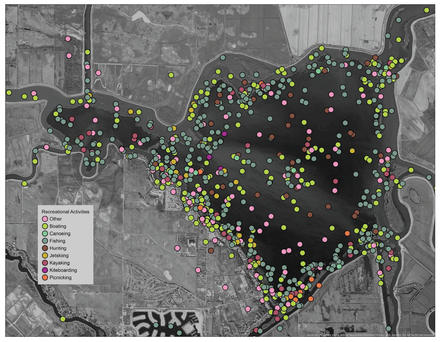
Where do you recreate and what activities do you do at this location? Results indicate the diversity of recreational uses and their use patterns across Franks Tract. Fishing appears to be most common along the vegetated remnant levees, which was validated in conversations with local anglers.
Figure 7.
Where do you recreate and what activities do you do at this location? Results indicate the diversity of recreational uses and their use patterns across Franks Tract. Fishing appears to be most common along the vegetated remnant levees, which was validated in conversations with local anglers.

Figure 8.
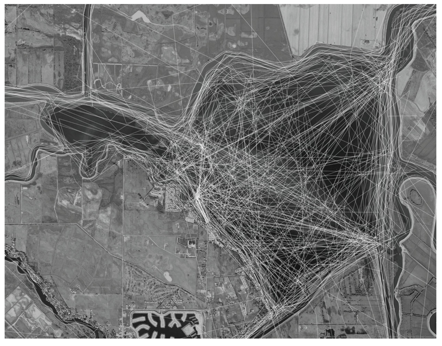
What are your regular boating routes across and within Franks Tract? Results indicate that Franks Tract is a major boating hub for both trips within Franks Tract as well navigation in the greater region. Results also reveal distinct traffic flow patterns across and within Franks Tract itself.
Figure 8.
What are your regular boating routes across and within Franks Tract? Results indicate that Franks Tract is a major boating hub for both trips within Franks Tract as well navigation in the greater region. Results also reveal distinct traffic flow patterns across and within Franks Tract itself.

Figure 9.
Where are desired sites for public access? What would you like to see? Results indicate that public access points are desired throughout Franks Tract, especially on the Bethel Island shoreline on Franks Tract’s West side. Common types of access included non-motorized and motorized launch sites as well as general public access to the water, which is non-existent currently. Contradictory opinions were presented at a later design workshop by Bethel Island residents and business owners.

Figure 10.
Where are the areas in Franks Tract that most need improvement? What improvements can be made? Results identify many types of desired improvement throughout Franks Tract, with some comments in opposition. Common improvements include addressing boating hazards (which includes removal of weeds, snags, submerged levee remnants and deepening of shallow areas).

Figure 12.
(a) Tidal marsh survey responses. (b) Superimposed on preferred alternative.

Figure 13.
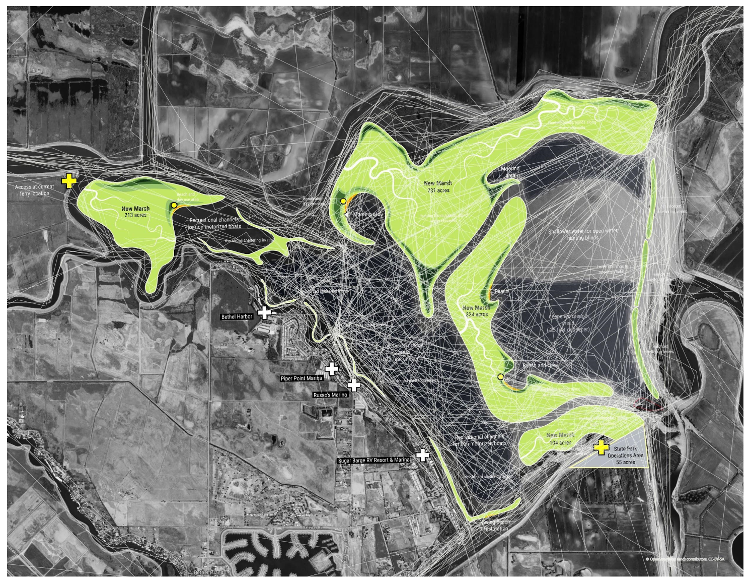
Boating route survey responses (white lines) superimposed on the preferred alternative.

Figure 14.
Overall comparative ranking of design concepts.

Figure 15.
No Action Alternative (NAA) community comments. (a) Places or features you dislike for NAA (b) Places or features you like for NAA.
Figure 15.
No Action Alternative (NAA) community comments. (a) Places or features you dislike for NAA (b) Places or features you like for NAA.

Figure 16.
Concept B (the preferred concept)-Central Landmass community comments. (a) Places or features you dislike for Concept B (b) Places or features you like for Concept B.
Figure 16.
Concept B (the preferred concept)-Central Landmass community comments. (a) Places or features you dislike for Concept B (b) Places or features you like for Concept B.

Figure 17.
Comparing participant categories across surveys.

Table 1.
Select sampling of state distrust/dissatisfaction survey responses.
| Subtheme | Examples (from Multiple Respondents) |
|---|---|
| Water grab | We need protection from Southern California water grab schemes. The tract has been and should continue to be a natural water resource. Any plans to alter or convert the tract so that more water can be exported needs to be strongly resisted. We need to institute long term restrictions on any and all “PLANS” for development and/or conversion of Franks or Little Franks Tract for other uses than are currently in place. |
| Economic impacts | What’s going to happen to the Bethel Island Marinas when you wall them off? Poker runs will no longer be stopping at Bethel Island and the bass fishing tournaments that go out from Russo’s or Sugar Barge will dwindle down to none. The restaurants and marinas that will be walled off from Frank’s Tract won’t get the business anymore. Those businesses support Bethel Island and give people a reason to come out here and buy homes here. Our local businesses will be negatively impacted and our property values will be impacted. |
| Government inflicted harm | If Mother Nature plays a roll it will thrive... if the government keeps spraying an using pellets to kill off the grass it definitely does damage |
| I can’t believe you are considering filling in so much of a designated State Recreation Area, known throughout the U.S. as one of the primo bass fishing sites. | |
| Non-intervention | Franks tract does not require a design or any management, save waterfowl blind placement. It should remain as it is and has been for my life. Little franks tract should be opened to waterfowl hunting, just like Franks tract. It is currently a wildlife sanctuary of some sort, all the signs are gone now. Please do not attempt to add islands or camping or anything else here. Some things are better left alone. These two very special places fit in that description. |
| If the state can keep their hands out. I see mother nature reclaiming the area as a tidal marsh. |
Table 2.
Select sampling of “leave it alone” survey responses.
| Subtheme | Examples (from Multiple Respondents) |
|---|---|
| Nature | leave it alone! It’s natural nature! |
| Leave it alone and let nature take care of itself like it has for the past 20 years. | |
| let nature take its course, leave it alone | |
| Don’t change a running system-preserve a piece of nature as it is! | |
| Do not change the natural landscaping! | |
| I would suggest that these areas and others remain untouched by human hands! | |
| Human intervention | Let nature take care of herself with out mans interference |
| Leave it alone, except in cases of safety. Man tried to impound it before, nature took it back. | |
| Design | Design? Manage?, Just leave it be. |
| Design? Don’t design it. Leave it alone but maintain boater access |
Publisher’s Note: MDPI stays neutral with regard to jurisdictional claims in published maps and institutional affiliations. |
© 2020 by the authors. Licensee MDPI, Basel, Switzerland. This article is an open access article distributed under the terms and conditions of the Creative Commons Attribution (CC BY) license (http://creativecommons.org/licenses/by/4.0/).
Share and Cite
MDPI and ACS Style
Milligan, B.; Kraus-Polk, A.; Huang, Y. Park, Fish, Salt and Marshes: Participatory Mapping and Design in a Watery Uncommons. Land 2020, 9, 454. https://doi.org/10.3390/land9110454
AMA Style
Milligan B, Kraus-Polk A, Huang Y. Park, Fish, Salt and Marshes: Participatory Mapping and Design in a Watery Uncommons. Land. 2020; 9(11):454. https://doi.org/10.3390/land9110454
Chicago/Turabian StyleMilligan, Brett, Alejo Kraus-Polk, and Yiwei Huang. 2020. "Park, Fish, Salt and Marshes: Participatory Mapping and Design in a Watery Uncommons" Land 9, no. 11: 454. https://doi.org/10.3390/land9110454
Note that from the first issue of 2016, this journal uses article numbers instead of page numbers. See further details here.