1. Introduction
The urbanization process is rapidly progressing worldwide, especially in developing countries. According to the United Nations, the world’s urban population quadrupled in the period between 1950 and 2018, at an estimated rate of 2.54% per year, which is much higher than the growth rate of the world’s population (1.62% per year in the same period). Currently, more than four billion people live in urban centers, which correspond to approximately 55% of the world’s population. Moreover, although the urbanization rate is expected to decrease, the percentage of the urban population will exceed to 68% by 2050, mainly as a consequence of the growing rural exodus in the world’s less developed regions [
1].
This rapid continuous process has caused the world’s cities to increase in number and size, thereby concentrating populations, infrastructures, and goods. Today’s cities are increasingly diverse and complex in their processes and dynamics, and their problems are equally diverse and complex, thus requiring new approaches, proposals, and initiatives to address these issues. This is even more evident in the current context of social, economic, and technological changes and considering the current environmental crisis, which poses new challenges to urban management and planning.
As in many other areas, spatial information is crucial for decision-making at the urban level; it is necessary to have records that are as complete and accurate as possible for proper management by the administration [
2,
3,
4]. In this regard, the cadastre and its processes represent a vital source of information in territorial and urban studies to gain knowledge of the territory and more accurately determine its resources, which is the basis for ensuring efficient planning [
5,
6].
Despite the technical difficulties associated with its implementation as (it requires knowledge of the data structure and the information that can be extracted from the data), the use of cadastral information has become widespread, with numerous applications, such as the planning and organization of territories, infrastructures, and public services (e.g., water supplies, sewage, and waste); urban development (the estimation of accurate appraisals based on the characteristics of each property); agricultural, forest, and environmental management; geomarketing; and the study of city growth [
7,
8,
9].
As with geographic information, the cadastre is based on spatial and thematic components (alphanumeric data on surface area, use, and building typology) [
10,
11]. However, the concept of the cadastre broadly refers not only to information on the cadastral object (at the physical, legal, and administrative levels) but also to the technology used for its management and visualization [
12,
13,
14,
15,
16]. Therefore, the so-called vertical registration of cadastral objects has been incorporated into the concept, referring to the limits of the parcel, and, concomitantly, to the use of technologies that enable the collection and registration of cadastral information in three dimensions (3D). Ho et al. [
17] used this method to illustrate the vertical division of a building into individual lots, with not only a physical delimitation of each cadastral object but also an administrative and legal allocation.
The 3D cadastre considers not only the area of the parcel and the built surface as a 2D cadastre but also the volume, which supports a more accurate assessment of taxes, thereby improving and increasing the taxation by different administrations [
3,
11,
18,
19]. However, taxation is not its only fundamental use. For example, the more accurate and detailed information provided by the 3D cadastre benefits urban planning, thus facilitating the redefinition of property boundaries with greater precision. When the integration of infrastructures and urban systems is more closely aligned with the real estate reality, the identification and location of public spaces can also be defined more accurately. Additionally, the 3D cadastre is also beneficial for proposing models for the most effective and efficient allocation of public utilities and services [
12,
20,
21].
Several countries have already started the transition towards the use of the 3D cadastre. Logically, the process must start from a previous analysis and diagnosis of the cadastral situation in each country, to determine the weaknesses and strengths of the different cadastral systems. This diagnosis is essential to assess the potential of these systems to extend cadastral models to support 3D cadastral implementation more closely adjusted to the reality and specific circumstances of each context [
3,
18,
22,
23,
24]. This type of diagnosis has been carried out in most Latin American countries, although, in some cases, it is only a partial diagnosis, such as in Ecuador, where it has been carried out only for the cadastral system of the Metropolitan District of Quito [
25]. Research focused on the analysis of the cadastral system and the legal registration of cadastral objects has also been carried out in Argentina, Brazil, Mexico, and Venezuela, which offers insight into the process of implementing a 3D cadastre [
26].
In this transition towards the 3D cadastre, most countries have chosen to align themselves with the ISO 19152:12 Land Administration Domain Model (LADM) standard, which offers specifications to integrate all the concepts of the cadastral domain to be as open as possible for implementation in different scenarios [
27]. Moreover, according to some results, this standard can contribute to a more viable implementation of the 3D cadastre [
28,
29,
30,
31,
32,
33]. In the different processes of 3D transition, an attempt is made to guarantee the security of property rights, as well as the proper registration and storage of cadastral objects [
34]. On the other hand, solutions are also being sought for the proper registration of both cadastral objects and the elements that are around them, including underground spatial objects, which need to be registered as a legal part of the space to define their responsibilities, rights, and restrictions (RRR) [
35,
36].
Based on the research initiated by the Permanent Committee of Cadastre in Ibero-America (PCCI), this study is aimed at assessing the reality of cadastre in Ecuador, the diverse problems of cadastral information in the selected decentralized autonomous governments (DAGs), how administration organize their cadastral data, and the structure of their databases. A series of criteria is proposed to determine the level of development of the analyzed cadastral systems and the possibility of adapting them to an initial LADM country profile for the transition towards a 3D cadastre.
This research offers a reference contribution for determining the degree of proximity of the cadastral systems to the 3D cadastral model. By defining the cadastral aspects that need to be evaluated, the level of cadastral development in the country can be determined. Based on the previous analysis, being able to develop an initial LADM country profile will provide a vital contribution to the transition towards the 3D cadastre.
The article is organized as follows:
Section 2 explains the current cadastral status of Ecuador.
Section 3 then analyzes the characteristics of the cadastral components of the eight selected cadastral systems and defines the criteria to be applied to determine the different levels of cadastral development. Moreover, we propose an initial LADM country profile based on the previous analysis considering national and international regulations.
Section 4 presents the results of the applied proposal and an initial Ecuadorian LADM country, which are then discussed in
Section 5, which also includes the general conclusions of this study.
2. Current Cadastral Status in Ecuador
According to Article 55, paragraph j, of the Organic Code of Territorial Organization, Autonomy and Decentralization (OCTOAD), the municipal and metropolitan decentralized autonomous governments (DAGs), through the National Directorate of Appraisals and Cadastre (NDAC; the maximum entity of the cadastre at the national level), are responsible for preparing and managing urban and rural real estate cadastres within their administrative areas. This separation partly explains the uneven level of development of municipal cadastral systems and the lack of uniform databases, which is impairing the creation of national spatial data infrastructure (SDI) for cadastral purposes [
37,
38]. Todorovski et al. [
39] reported, for example, that of the 221 municipalities, 140 (63.3%) have already implemented georeferenced urban cadastre projects, while 34 have not. Their study also revealed that Ecuador has diverse procedures for collecting, storing, processing, and visualizing cadastral data, which do not always comply with national standardization guidelines. Moreover, it is also common for cadastral information to be used exclusively by each municipality, without the possibility of integrating it with information from neighboring municipalities [
39].
In compliance with national regulations (Article 36, OCTOAD), DAGs are also responsible for updating their cadastral information every two years, with their own reformulations or procedures. The OCTOAD is one of the national regulatory references for generating, standardizing, and updating georeferenced cadastral information. Articles 139, 494, and 496 establish the obligations to update cadastres and property appraisals every two years, according to the terms stipulated in the OCTOAD, with notifications given to property owners [
40].
However, in 2016, the Ministry of Urban Development and Housing (MUDH) approved Technical Standards for the cadastres of urban–rural real estate and property appraisals and the operation and fee calculations for NDAC technical services to improve cadastral management processes in the country (Ministerial Agreement 029–16, Executive Decree No. 688). This provides another reference standard for all DAG on the use of conventional and standardized methods to manage and update their cadastral databases. For example, Article 7 refers to the components of a multi-purpose cadastre with minimum contents; Article 8 specifies the minimum specifications for base cartography defined by the Geographic Military Institute; Article 17 mentions the minimum cadastral products that a DAG must have; and Chapter VIII stipulates the minimum requirements for a local cadastral geographic information system (LCGIS) to guarantee the support and implementation of the technological components for storing, processing, and visualizing cadastral data [
41].
Apart from these national standards, initiatives such as the National Information System and Management of Rural Lands and Technological Infrastructure program of the Ministry of Agriculture, Livestock, Aquaculture, and Fisheries have contributed to a significant increase in Ecuador’s cadastral coverage and facilitated updating and, to some extent, standardizing municipal cadastral systems. This program generated a wide set of spatial data and cartographic products of unquestionable relevance for improving territorial planning and the coordination of the country as a whole, including aerial photographs at a scale of 1:5000, which provide a valuable source of information for cadastral purposes. While waiting for a desirable renewal of this 2010–2014 program, most DAG are currently contracting external consultants to acquire aerial photographs.
In April 2011, the PCCI published a report on the state of the cadastral information for the different countries in the region. The report compiled information from surveys carried out among representatives of the twelve countries of the PCCI, aimed at highlighting several purposes of the cadastres as the foundation of territorial planning. The report included information related to the owner, the cadastral object, and taxes, in which compliance with the characteristics of each of the previously mentioned aspects was specified. It should be noted that the report was prepared with the information available for each country; for Ecuador, the Metropolitan District of Quito was taken as a reference, and the results of the analysis were extrapolated to the entire country. However, as expected, the cadastral reality of the capital, as with many other aspects, can be remarkably different from that of the rest of the country’s cantons.
The PCCI report, based on the information provided by the Metropolitan Directorate of Cadastre of the Metropolitan Municipality, highlighted the low percentage of cadastral coverage in Ecuador, which was only 40% as well as the predominant provision of data in registries and maps at scales ranging from 1:25,000 to 1:5000. The report also noted that raster data accounted for 22% of urban cadastral coverage and that digital data did not exist for all real estate cadastres. Furthermore, the report emphasized the obligations of the owners to declare the physical changes of a cadastral object, for which the competent entity, following the provisions of the Manual of Procedures No. 22 and the Law of Ordinances [
25], was responsible for incorporating and updating the cadastral data. These aspects suggest an enormous weakness in the Quito cadastral system and, by extension, in the Ecuadorian system, which is deficient when compared to the standards and quality of more developed systems. According to the PCCI, a rigorous diagnosis of the situation of each Ecuadorian cadastral system, or at least of a few systems, is required to subsequently provide solutions to improve efficiency and effectiveness. Among these solutions, the implementation of a national strategy would integrate the management of information and cadastral systems throughout Ecuador, thereby providing concrete and viable solutions for the contribution of cadastral information, not only for greater tax efficiency but also as a tool to support all national policies aimed at promoting the country’s territorial, social, and economic development [
25].
3. Materials and Methods
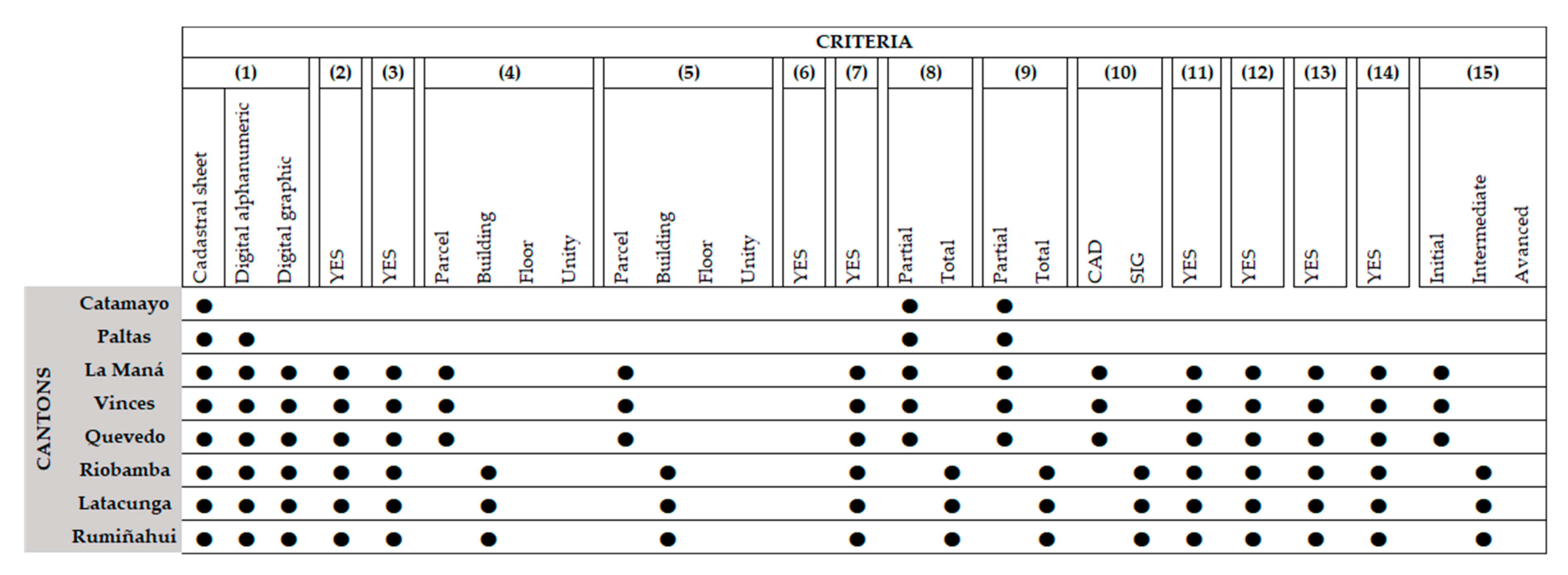
This study has considered several stages. Firstly, it was necessary to identify the cantons with the greatest availability of information related to cadastres to carry out a more exhaustive and realistic analysis of the cadastral situation in Ecuador. Afterwards, semi-structured interviews were conducted with technicians and experts from the land administration of the eight selected cantons; likewise, their cadastral databases were also analyzed considering the fulfillment of the aspects listed in
Table 1 corresponding to national cadastral components. The evaluated aspects were defined from a bibliographic review of previous studies carried out in Ibero-American countries, as well as considering the basic parameters of cadastral components of the national regulations (Ministerial Agreement 017–20). The results of the analysis of the interviews and the cadastral databases made it possible to define the levels of cadastral development based on compliance of the aspects related to the basic components of Ecuadorian cadastres. Finally, based on the results of the country’s cadastral development trends, an initial LADM country profile was proposed that could contribute to begin the path towards 3D cadastre.
The availability of and ease of access to cadastral databases was the preferred criterion for selecting the cantons for this study. The cadastral information in Ecuador is not fully available to the public; in most DAG, physical access to data is limited and prior authorization is usually required from the responsible administrative body, such as the NDAC of the DAG, often on a discretionary basis or depending on the interest of the study.
Choosing cantons of different ‘planning areas’ was also a priority, with areas distributed throughout the nation, and with economic, social, and cultural diversity. In accordance with Ecuador’s current administrative divisions, the country’s areas, districts, and circuits provide “decentralized levels for the administration and planning of public services in some ministries” of Ecuador [
42]. A total of nine planning areas have been defined, which are divided into provinces, districts, and circuits: “From this level, public sector entities are strategically coordinated (...) for the design of policies in the area of their jurisdiction” [
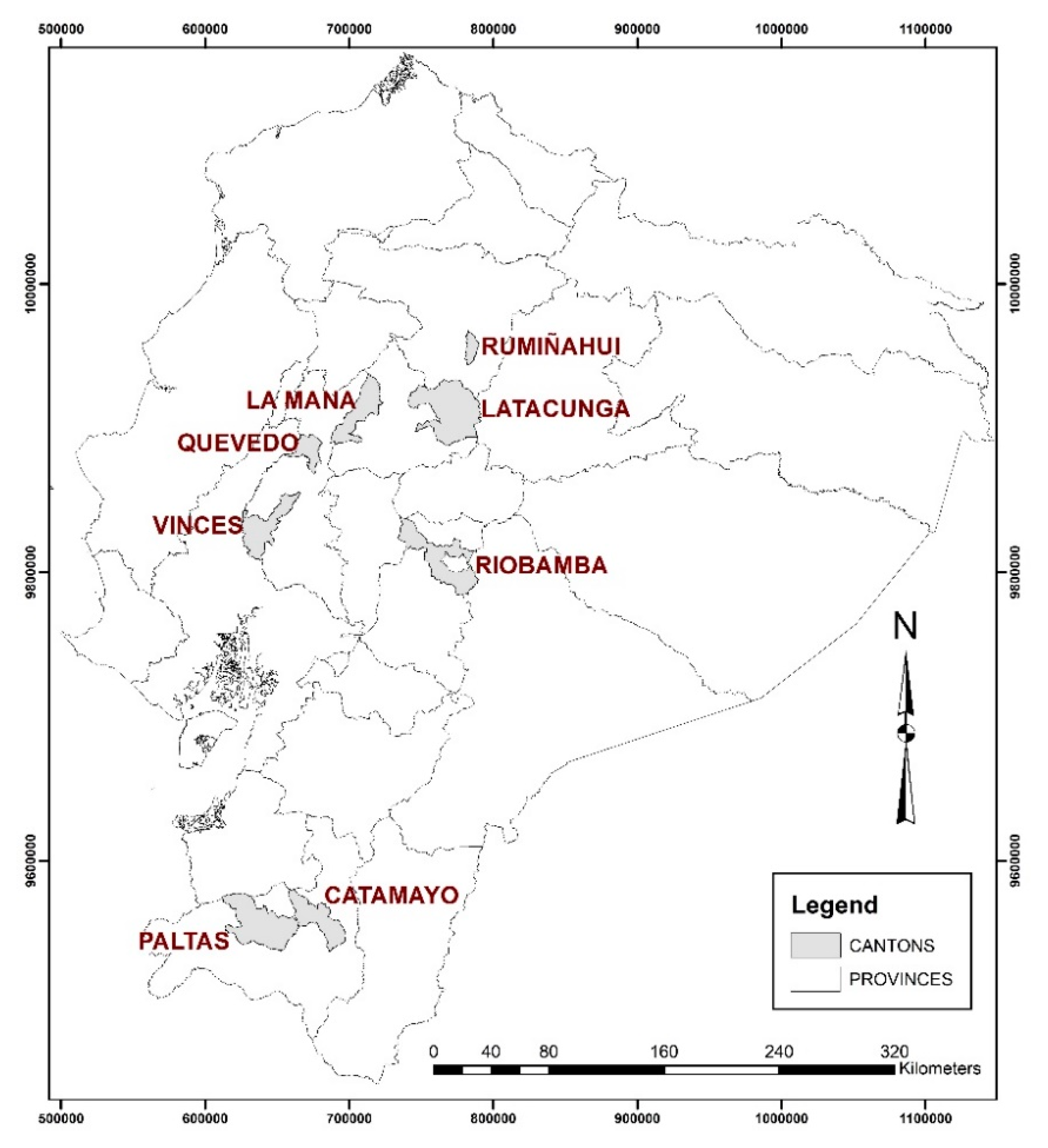
42]. The selected DAGs are shown in
Figure 1, with a total of eight cantons from five different provinces (Chimborazo, Pichincha, Cotopaxi, Loja, and Los Ríos) and in four different planning areas (areas 2, 3, 5, and 7).
Previously, as a fundamental part of the study, 19 in-depth interviews were carried out with municipal personnel (5), cadastral analysts (8), and section heads (6) from departments such as appraisals and cadastre, planning, and technological and systems management of the selected cantons. These interviews were semi-structured interviews for different land administration professionals that, with prior authorization, were recorded. The criteria used to select the interviewees were diverse, and based on the degree of knowledge each participant had of the canton’s cadastral system at the time they participated in the cadastral processes to ensure that, all respondents were similarly representative of the different administrative levels of the municipal DAG. Before conducting the interview, several meetings (from 2 to 4) were scheduled with each of the selected interviewees to determine a first approximation of the cadastral reality of each canton and adapt the interview to it. The objective of these interviews was to gain first-hand knowledge of the processes adopted in each case, as well as details related to the generation, storage, and management of the cadastral systems and information.
Table 1 presents the priorities of the research. Of particular interest are the priorities related to the basic physical characteristics of each cadastral base, specifically those that would support the transition from the currently dominant use of 2D cadastres to the use of 3D cadastres, as proposed by Aien [
43].
The 15 characteristics listed in
Table 1 were determined from those used in the PCCI report [
25] to analyze and evaluate the cadastral status in Ibero-America these also coincide with the characteristics used in the analysis of 3D Cadastre in four Latin American countries [
26]. Likewise, aspects of the four components (physical, legal, economic, and thematic) of the Ecuadorian cadastre were considered, as established in the national regulations (Chapter I, Article 7, of the Ministerial Agreement 029–16 [
41] and in Section II, Article 11, of the Ministerial Agreement 017–20) [
44]. The characteristics of the physical components (items 1–10) represent most of the characteristics considered in this research; the characteristics analyzed are fewer for other components (two for the legal component (items 11 and 12) and one for the thematic component (item 13) and economic component (item 14)).
The physical component was analyzed based on whether the cadastral data are stored in a digital format (alphanumeric, geographic, or both) or collected in analogic cadastral files stored in the archives of each cantonal DAG (item 1). Thus, based on the provisions of the national standards, we determined if there were georeferenced data available on the cadastral object (item 2), using the UTM coordinates and WGS84 datum. Currently, it is not possible to understand the cadastre without a georeferenced graphic representation of its information, expressed by a projection system and its coordinates (x, y). It is also necessary that the information be limited not only to a letter description or geometric representation of the cadastral objects.
However, it was critical to verify whether the cadastral system has a geospatial database and contains descriptive data and documentation on the characteristics of the cadastral object (item 3).
Another important aspect of the analysis was to identify the level of disaggregation of the graphic and alphanumeric cadastral data (property, construction, floor, or unit; items 4 and 5), which are essential to determine whether the graphic representation of the cadastral object is closer to the 2D or 3D cadastre model. This determination indicates whether the data are at the same level, updated jointly, and, above all, linked through the cadastral code (item 6), which provides a unique and unrepeatable identifier, as required by the guidelines of the Ecuadorian standards (Ministerial Agreement 029–16) [
41]. All these aspects will support the future unification of all the cadastres and the establishment of a single national system (item 7).
The information on the physical characteristics of the cadastral object (item 8) was also analyzed, in accordance with Chapter I, Article 7, of the Ministerial Agreement 029–16, which specifies the minimum elements of the physical cadastral component, both at the property and construction levels. We also looked at complementary works and characterizations of dwellings, which are essential information to determine whether the data best adapts to a 2D or 3D cadastral model. Moreover, the availability of information regarding the services and facilities on the premises was included, such as the types of access roads, electricity, urban transport, and water, among others (item 9).
The degree of the implementation, adoption, and application of storage systems and the general management of geographic information (e.g., geographic information system (GIS) and computer-aided design (CAD)) were also evaluated considering the stipulations in Chapter VIII of the Ministerial Agreement 029–16. These aspects may be decisive when facing the technological challenges of moving towards a 3D cadastral model (item 10).
For the juridical component, we analyzed the existence of basic information related to owner/co-owner, possession, and domain based on fulfillment of the basic information required by the Ministerial Agreement 017–20 in Section II, Article 11, point 3, letters ‘a’, ‘b’, and ‘c’.
Similarly, this study aimed to analyze the existence of base cartography (item 13) related to, for example, the political-administrative divisions and elements of the physical environment, infrastructure, and equipment together with the cadastre data so the data could be used for multiple purposes beyond classic tax purposes.
On the other hand, the information on property values was analyzed in the economic component according the information established in Section II, Article 11, point 1, letters ‘a’, ‘b’, and ‘c’ of the Ministerial Agreement 017–20 (item 14).
Finally, in item 15, the interviewees were asked to provide a qualitative assessment of the general situation of the cadastral system of their canton and an initial assessment of the position (from none to advanced) that, in their opinion, the cadastral system should occupy to address the challenges of the future implementation of 3D cadastral models.
Once the cadastral databases and semi-structured interviews were analyzed, the levels of cadastral development were defined. For this, the degree of compliance for each of the aspects detailed in
Table 1 was taken into consideration. This allowed us to identify the trends of cadastral development in the cadastral systems of the country.
Finally, based on an analysis of the cadastral systems of Ecuador, an initial LADM country profile was developed. This consolidated the general aspects of the components (physical, legal, economic, and thematic) of the national cadastral regulations together with the basic classes (LA_Party, LA_RRR, LA_BAUnit, and LA_SpatialUnit) of ISO 19152:12 LADM. This initial proposal considered the predominant level of cadastral development in the country as a whole. In addition, the initial model focused mainly on the aspects of the physical component for which the spatial unit is specified as a parcel.
4. Results
4.1. Analysis of Cadastral Systems Based on Several Aspects
Ecuador has national standards for cadastre, such as the technical standards of cadastre for urban–rural real estate and property appraisals through the Ministerial Agreement 029–16 [
41], which must be considered by municipal and metropolitan DAG. However, this study found that not all cantons follow the guidelines stipulated by national standards, which leads to significant limitations in the updating and maintenance of cadastral information. However, Ecuador’s cadastral information continues to have restricted access and, as a standard procedure, prior authorization from the DAG is required, even for consultation. As previously mentioned, this limitation influenced the selection of the cadastral systems analyzed in this study, which were limited to cantons allowing access to a greater amount of cadastral data and information related to the cadastral process.
A detailed analysis of the cadastral systems and databases allowed certain patterns, differences, and coincidences to be detected in the analyzed characteristics and criteria. Therefore, it was possible to determine the level of development of the systems in relation to the 3D cadastral model, thereby consolidating the general assessment made in the initial analysis. This information was then used to establish whether the cadastral information of these DAG has characteristics and properties that would allow one to extend the cadastral data model to support a 3D cadastre approximation (in its basic contents, the physical characteristics of the objects, basic information regarding owner/co-owners, possession, domains, and property values, among others) and thus determine more precisely how well these DAG are positioned to meet that challenge.
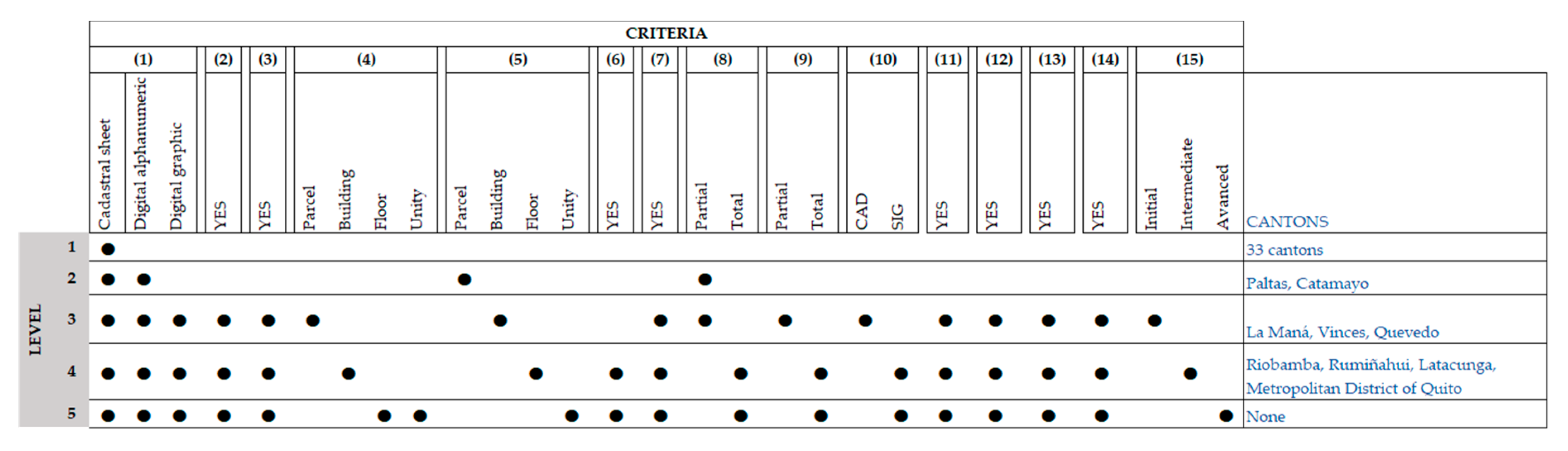
A classification using five levels was proposed according to the criteria and characteristics described in the previous section (see
Figure 2).
Figure 3 shows detailed results of the analysis of the selected cadastral systems, which reflect an evident lack of uniformity in the fulfillment of the criteria.
A Level 1 (primitive cadastre) would only comply with the first criterion. The system contains the relevant information in the cadastral records, but not in a digital or georeferenced format; therefore, there is no link between the graphical and alphanumeric information and no system for managing the database. The updating and recording of changes are thus impaired and entail a greater cost of time and resources. This level includes the cadastral systems for 33 of the country’s cantons, which, according to a study by Todorovski et al. [
39], present their information in an analog format and do not feature georeferenced data. In reference to the legal and economic component, these systems provide very elementary information contained in the cadastral sheet and are also not periodically updated according to Ecuadorian regulations.
A Level 2 (Incipient 2D-cadastre) includes cadastral information collected in analog cadastral sheets, although alphanumeric information at the level of the property is available in a digital format. The system does not include georeferenced data, graphical data, or base cartography, nor does it include a geodatabase; therefore, there is no system for managing it. However, the cadastral object identifier does not comply with the specifications of the Ministerial Agreement 029–16 [
41], making it impossible to link cadastral data in different formats. The system has partial information on the physical characterizations of the cadastral object, which makes it difficult to update; it also does not incorporate information on the canton’s infrastructure or basic services, making it more difficult to estimate the appraisal and use it for purposes other than taxation. On the other hand, like Level 1, there is more very basic information about the owners/co-owners, possessions, domains, and property values, except that the information is found not only in the cadastral sheet but also as alphanumeric data. This level includes the cadastral systems of Paltas and Catamayo, both in the province of Loja (planning area 7).
A Level 3 (Intermediate 2D-cadastre) stores the cadastral records in a digital format, although the digital graphic files at the level of property and the alphanumeric digital files at the level of construction are not linked, which makes it difficult to determine the aspects related to the owner, the cadastral object, and the relevant responsibilities, rights, and restrictions. This system has a cadastral object identifier in both the graphic and alphanumeric data, but, because there is no identifier at the same level, the data cannot be linked. The cadastre includes georeferenced data and base cartography in the same geodatabase, which is managed in CAD software and it does not meet the national requirements highlighted in Chapter VIII of Ministerial Agreement 029–16. The legal and economic components are like those of the L2 level. It provides partial information on the physical characteristics of the cadastral object and also on the basic services that exist in the canton but does not incorporate other characteristics that would support a more advanced cadastre. At this level, it presents an initial state of the cadastre model for implementation of a 3D cadastre since it complies with the basic elements of the four cadastral components stipulated in the Ministerial Agreement 017–20 (mainly the physical component). This includes the cadastres in the cantons of La Maná (province of Cotopaxi) and Vinces and Quevedo (both in the province of Los Ríos; planning area 5).
In a Level 4 (Advanced 2D-cadastre), alphanumeric information is collected in digital cadastral files, both at the construction and at the floor levels, which are linked through the cadastral object identifier, which complies with the specifications of the Ministerial Agreement 029–16 [
41]. All data, information (graphic-spatial, thematic-alphanumeric), and available base cartography, are stored in the same geodatabase, managed by GIS, allowing the canton cadastral systems to be used for multiple purposes. The system contains complete information on the minimum elements of the physical cadastral component, including the characteristics of the cadastral object and the services, according to the specifications of Chapter I, Article 7, of the Ministerial Agreement 029–16. In addition, QGIS is a free software, licensed by GNU General Public License (GPL) (QGIS Development Team,
https://qgis.org/es/site/), which is most commonly used by the majority of DAG. QGIS complies with the characteristics of the national regulations mentioned in Chapter VIII of Ministerial Agreement 029–16. On the other hand, information on the legal and economic components specified by national regulations is included, which is also in a digital format and linked to information on the physical and thematic components; however, the update process is not as periodic unless the owner formally requests it. Additionally, at this level, it mostly complies with elements corresponding to the physical, legal, economic, and thematic components stipulated in the national regulations, which would provide the initial state of the cadastre model for the implementation of a 3D cadastre. Despite not complying with all the proposed characteristics (but including indications of an initial 3D cadastral model), this level includes the cadastral systems of Riobamba (province of Chimborazo), Rumiñahui (province of Pichincha), Latacunga (province of Cotopaxi), and Quito.
None of the analyzed cadastral systems would be included in a Level 5 (3D cadastre), in which all the characteristics necessary to propose a highly developed 3D cadastral model at the level of the physical, juridical, economic, and thematic components are provided. Unlike the previous level, the graphical and alphanumeric information, at this level, are found at the level of the unit and are linked together, which allows a 3D cadastral model to be implemented unambiguously. The digital cadastral information has fine detail and makes it possible to define aspects related to the owner, the cadastral object, and the rights, responsibilities, and restrictions.
The cadastral systems of the studied cantons have intermediate levels of development (Levels 2, 3, and 4). Of these, the cadastres of the Metropolitan District of Quito and the provincial capitals are at the most advanced level (Level 4) for meeting most of the criteria and characteristics.
The six cadastral systems at Levels 3 and 4 include georeferenced data, which indicates that they include a literal and graphical database. However, this information is not linked in any of the systems, and the graphic cadastral data are at the property level, falling to the construction level for the cadastres of Riobamba, Rumiñahui, and Latacunga. The alphanumeric information at the floor level is also available for these three cantons only. They also include georeferenced data and a geodatabase with base and cadastral cartography managed by a local GIS, as indicated by the Ministerial Agreement 029–16 in Chapter VIII. It should be noted that, although they provide base cartography, there is a difference in the quantity of data that each canton has available. Moreover, these systems provide complete information on the services of the property and the characteristics of the cadastral object. However, they all have and use the cadastral code in its national standardized format for the identification of the property.
However, the cantons of La Maná, Vinces, and Quevedo indicate Level 3 cadastral development. In their cadastral systems, the graphical data are at the level of the property and the alphanumeric data are at the level of the construction. These systems include partial information on the services of the property and the characteristics of the cadastral object and use CAD systems to manage their graphical cadastral data.
The cadastral systems of Catamayo and Paltas indicate Level 2 development (an initial 2D cadastre), with alphanumeric information at the property level and, therefore, limited information on the cadastral object. They also present partial information on physical characteristics and basic services.
The cadastre of the Metropolitan District of Quito, which has been used as a reference in other studies for the country’s cadastral assessment, was classified with Level 4 development. As reported in studies by Ojeda [
45], Parra [
8], and the PCCI [
25], this system meets most of the criteria and characteristics considered at this level, although it is still far from a 3D cadastral model. The cadastres of the cantons of the provincial capitals (Latacunga and Riobamba) and Rumiñahui are also included in this level, with the latter mostly due to relevant research agreements with the University of the Armed Forces-ESPE [
46,
47,
48,
49].
Ecuadorian planning and zoning show that cantons belonging to the same area had similar characteristics and levels of cadastral development. The cantons in areas 2 and 3 (Riobamba, Rumiñahui, and Latacunga) in the central and north-central regions of Ecuador and the Metropolitan District of Quito (which represents area 9) had advanced systems (Level 4). Those in the planning area 5 or on the coast (Vinces, Quevedo), together with La Maná (in area 3), had characteristics typical of intermediate 2D cadastres (Level 3). Finally, the cadastral systems of the cantons in area 7 (Paltas, Catamayo), which is located in the southern region and includes small cantons that are not provincial capitals, had Level 2 development, corresponding to an incipient 2D cadastre.
4.2. Developing an Initial Ecuadorian LADM Country Profile
Based on the analysis of the cadastral situation in Ecuador, an initial LADM country profile was proposed as a starting point for the transition to a 3D cadastre. In the profile, the four components of Ecuadorian cadastres were aligned with the basic classes proposed by ISO 19152:12 LADM.
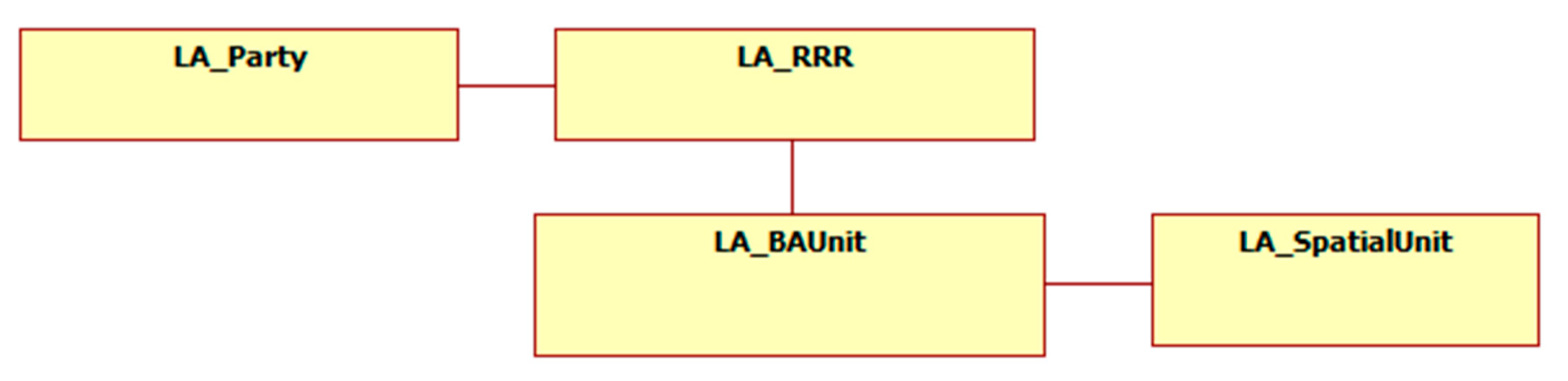
Figure 4 shows the essence of this regulation, which comprises of four basic classes: (1) LA_Party refers to the interested party (owners); (2) LA_RRR states the rights, responsibilities, and restrictions on the real cadastral object; (3) LA_BAUnit represents the basic administrative unit; and (4) LA_SpatialUnit refers to spatial units such as parcels, buildings, and parts of buildings [
27].
Considering that the cadastral development of the Ecuadorian cantons tended toward an intermediate level, it is possible that the components of the national cadastral regulations are represented in the general model proposed by LADM with the respective particularities of the national cadastre.
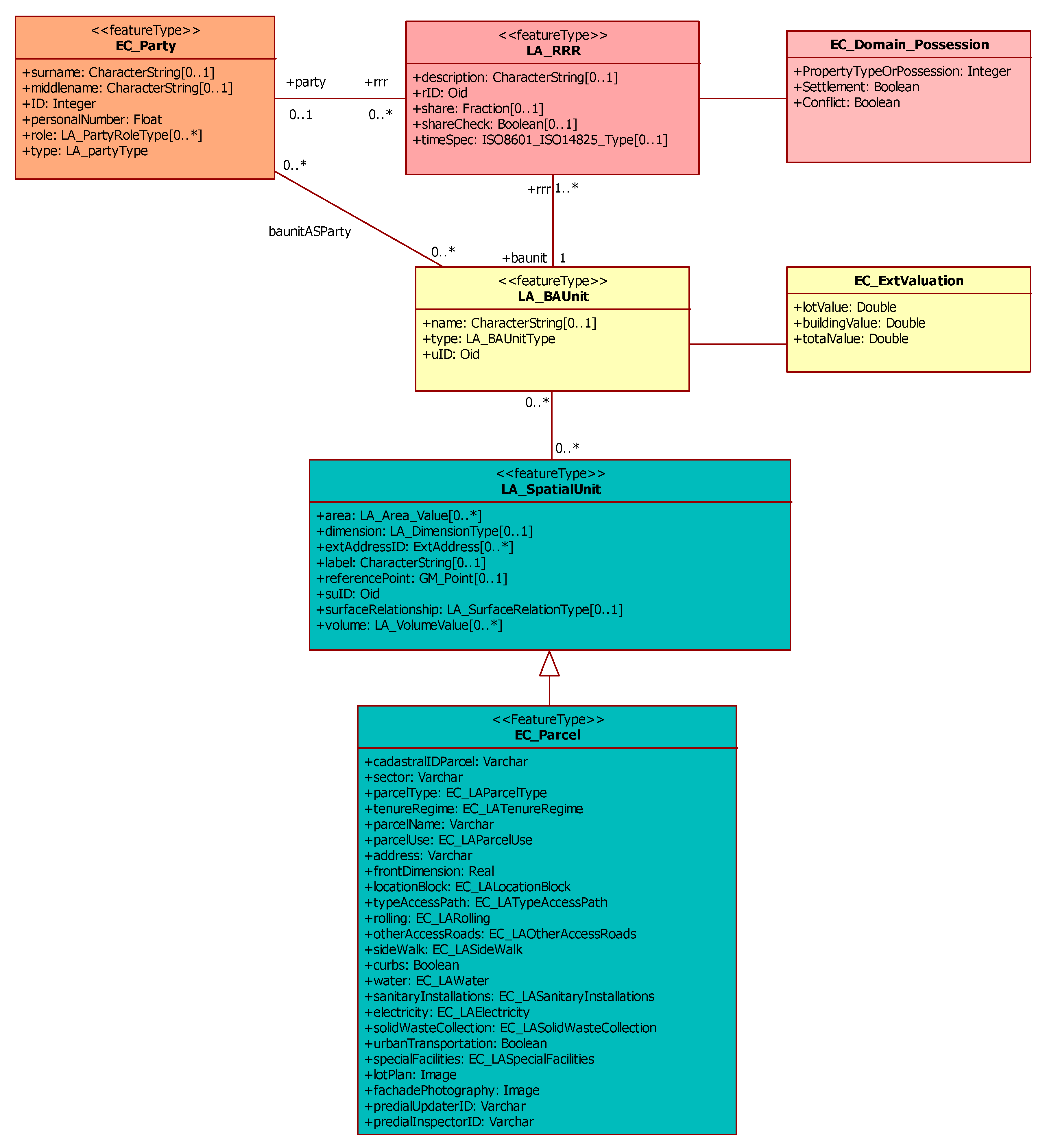
Figure 5 illustrates the initial LADM country profile considering the legal, economic, physical, and thematic components. Each of the basic classes is detailed below in the subsections where the particularities adapted from the national regulations to ISO 19152:12 LADM are specified.
LA_Party corresponds to the owners/co-owners. In the case of Ecuadorian regulations, it corresponds to the legal component (letters ‘a’ and ‘b’), which includes the basic data on the owner and/or co-owner. The ‘type’ attribute must specify whether the owner is a natural person or a legal person; in both cases, it will always have a unique identification known as the ‘ID’. In the case of a natural person, the mandatory data are the person’s full name and surname, as well as his or her spouse, if applicable. On the other hand, for a legal person, it must be specified whether that person is public or private and must also include data such as a business name. In the case of co-owners, the corresponding percentage of the property must be specified.
The LADM considers the rights, responsibilities, and restrictions in the class LA_RRR. On the other hand, in the Ministerial Agreement 017–20, the legal component (letter ‘c’) includes information on the domain or possession. In this section, the form of ownership or possession is considered, for which the code list indicates that attributes 1–8 correspond to ownership and 9–11 to possession. The settlement of fact and conflict is also considered here, which is a Boolean type since true or false indicates the existence or non-existence of the aforementioned attributes. This section on the national regulations is adapted in the RRR section of the international regulations, as illustrated in
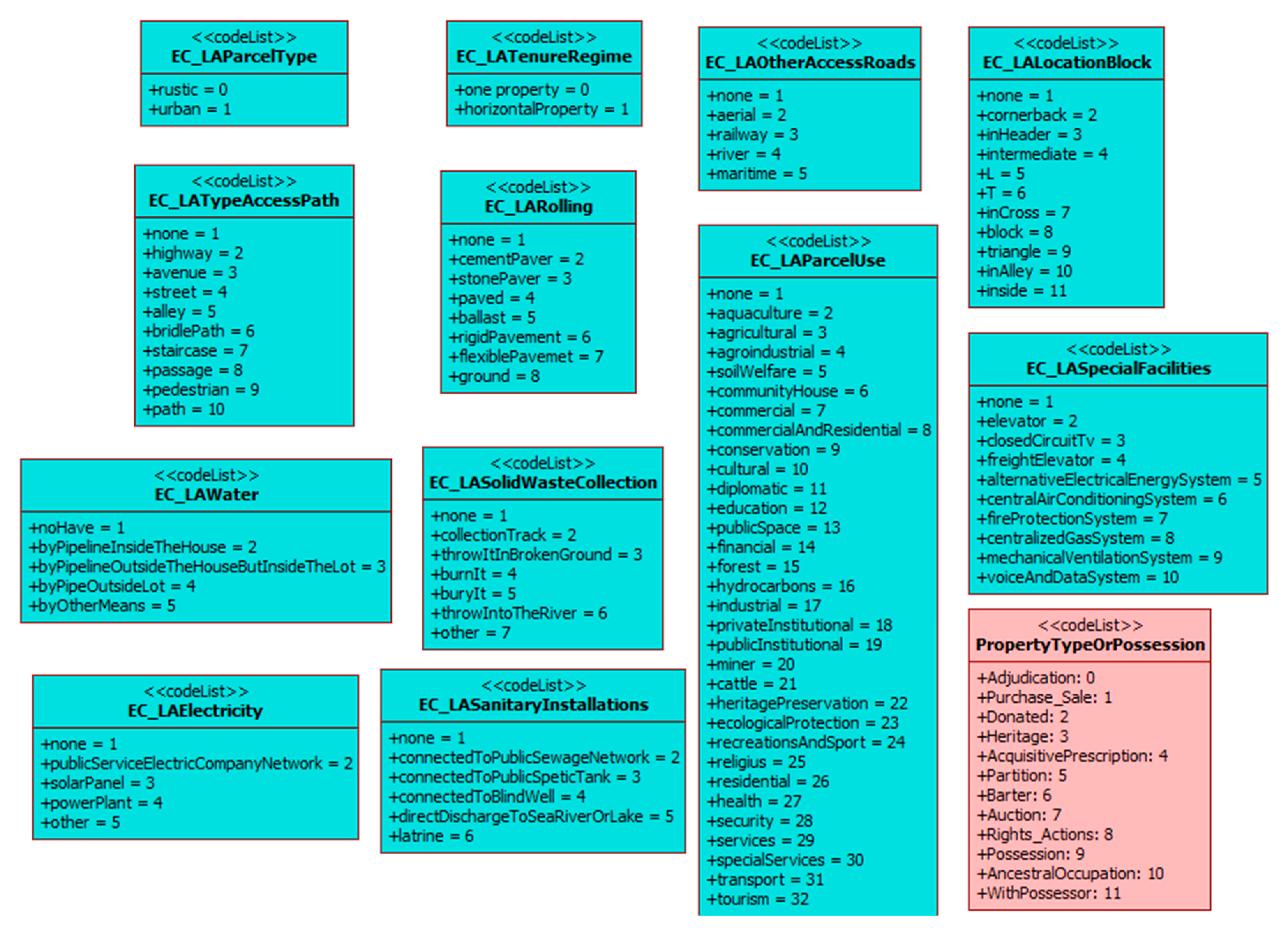
Figure 6. Moreover, the code list referring to the type of property or possession was developed based on the national regulations maintaining the codes and labels.
Section II, Article 11, Item 1 of Ministerial Agreement 017–20, specifies that the minimum elements of the economic component are: land value, the value of buildings, and the total value of the property (land and buildings). This economic component corresponds to the ExtValuation class, which allows one to record the valuation data. Moreover, this class is associated with the basic class LA_BAUnit.
The international standard ISO 19152:12 LADM presents the basic SpatialUnit class, which describes spatial units such as the parcel, buildings, and/or part of the buildings. On the other hand, Section II, article 11, item 2 of Ministerial Agreement 017–20 corresponds to the physical component, which refers to the parcel in letter ‘a’. Therefore, the minimum elements of the physical component correspond to the basic SpatialUnit class of ISO 19152:12 LADM.
Considering both national and international regulations, the class of SpatialUnit is broken down into a parcel. Among the main attribute corresponding to the parcel is the cadastral key (cadastralIDParcel). This key is a unique identifier of the cadastral object that considers its geographical location and has an official codification according to the National Institute of Statistics and Censuses (INEC). The cadastralIDParcel allows one to link the thematic information to the different spatial units. The other attributes of the parcel make reference to the characteristics of the property (use, graphic area, dimensions, facade registration, plan, and location of the block) and also to information related to the infrastructure and services on the property (types of access roads, sanitary facilities, electrical energy, communications, water, sidewalks and curbs, and urban transport, among others). The aforementioned attributes consider the Ministerial Agreement 017–20 [
44], with respect to the characteristics of the data, in which all the information are recorded, including the type, length, precision, tables, and observations for specific cases.
Additionally, the code lists are based on the specifications included in the general scheme of the basic cadastral data of Ecuadorian regulations (Ministerial Agreement 017–20) so that all municipal cadastral systems in the country use the same standard coding (see
Figure 6).
5. Discussion and Conclusions
There are national standards for collecting, processing, updating, and storing cadastral data, but not all cantons have complied with the regulatory guidelines consistently because the municipalities of each canton have autonomy in their processes, including those related to the cadastres. This is a key factor that influences the difference in the development of cadastral systems in each DAG.
The specificities and different levels of development of the analyzed cadastral systems seem to derive from this autonomy of the DAG in the implementation of their cadastres. However, these differences may also be related to territorial imbalances that exist in Ecuador between the cantons, provinces, regions, and planning areas, which entail differences in terms of economic and human development, poverty, and the availability of resources, among other issues.
Cadastral operations and processes involve significant economic efforts for local administrations with vastly different economic and budgetary situations that naturally introduce new elements of distortion and differentiation into the level of the development of the Ecuadorian cadastral systems. For example, compliance with the updating periods and the necessary rigor and efficiency are highly influenced by the economic, material, technical, and human resources available to each canton.
León [
50] previously indicated that, even at the beginning of the 21st century, Amazonian and central Andean provinces had the highest poverty rates, compared to provinces such as Pichincha, where “most of the country’s production, industrial, and commercial activity, with greater human development and less human poverty” was (and still is) concentrated. However, as Cabrera et al. [
51] noted, there is high heterogeneity among the cantons in each region and provinces in Ecuador (i.e., in terms of poverty and consumption inequality). Moreover, although many indicators have evolved positively, rural areas and the Amazonian region continue to show the lowest social and economic development [
52]. In short, there are differences in the availability of resources, especially financial economic resources, to address expensive processes.
Despite the establishment of planning areas (a new political-administrative level of the state), which are intended to improve the efficiency of public investment in the cantons, Benavides [
53], Iza [
54], and Peña [
55] emphasized the shortcomings that are conditioning a lower level of development, such as the lack of an association between graphical and alphanumeric data, the non-standardized cadastral data, and the non-automated cadastral processes, of the cantonal cadastral systems in less advanced areas of the country. These studies also refer to the different cadastral development levels of systems in small cantons and those in provincial capitals, mainly due to their differences in the availability of economic, human, material, and technological resources.
At the administrative level, each municipality assigns cadastre-related competencies to different departments, which means that the information is highly fragmented, and, in many cases, is only partially accessible. This situation is further complicated by the temporality and high employment instability that exists at this level of the Ecuadorian administration. Since cadastral processes are assigned to temporary personnel, the procedures that are periodically modified are not consolidated, which occasionally leads to a loss of information during transition periods.
In such a decentralized and fragmented scenario, access to information, and, therefore, any attempt to analyze and assess the Ecuadorian cadastral system is significantly impaired. Benavides [
53] analyzed the information management computer systems in the cantons of the province of Cotopaxi (Ecuador) and noted that there is no direct link between the systems of the departments responsible for the cadastres, thus depicting a scenario of disseminated information in which common information is not routinely shared between departments, thereby affecting its management. According to the same author, this situation, also identified in our study, frequently occurs in most Ecuadorian cantons of low and intermediate development, and raises the urgent need to promote the creation of databases that, although disaggregated in different departments of the cantonal administration, can be managed and integrated centrally.
In addition, this information is not usually available to the public, instead requiring prior authorization from the municipal DAG for consultation. As previously mentioned, this limitation has influenced the selection of the cadastral systems that were analyzed in this study, which were limited to those that allowed access to as much information as possible (spatial and alphanumeric data, cadastral files, etc.). This bias may have also influenced the results obtained in this study and the proposed classifications. However, several canton systems were analyzed, both at the demographic and urbanistic levels, which belonged to different provinces or planning areas with different levels of development and may thus adequately represent the diversity of Ecuador’s current reality.
The items used in the analysis supported the assessment of the cadastral situation in the different cantons, and, by extension, provided an approximate perspective of the country’s situation. The eleven physical characteristics were selected because they were the most commonly mentioned features in the literature and, in some international studies [
25], were particularly relevant in the characterization and implementation of 3D cadastral models.
It has been demonstrated that cantonal cadastres still have serious limitations, such as the link between graphical and alphanumeric information, cadastral codes that are not updated or not available at all levels, or updates to cadastral information. Zhidón et al. [
56] insist that proper management of the cadastre in Ecuador must necessarily go through the full integration of graphical-spatial and alphanumeric information and the implementation of a local cadastral GIS, thus complying with the requirements of the Ministerial Agreement 029–16 in Chapter VIII. As mentioned above, the OCTOAD stipulates that the cadastres must be updated every two years, but it is not easy for many municipal DAG, who often have poorly structured databases and limited resources, to comply with this requirement. According to Quinn [
57], a solution in many South American countries could come, in part, from free and open source software for GIS (FOSS GIS). In Ecuador, for example, this software would allow many municipal DAG to include these systems without significant financial investments, in addition to complying with national regulations regarding the implementation of a local GIS.
In the analysis of the cadastral information in the cantons in the province of Azuay (Ecuador), Peña [
55] noted that this information was still frequently collected manually, using slow, non-automated methodologies, with a significant cost in terms of time and resources (both economic and human). This situation, as demonstrated in this study, is not unrelated to other Ecuadorian cadastral systems and entails difficulties in updating the information. These challenges can have serious repercussions on the quality of the information, and, consequently, affect the adequate planning of these territories, among other aspects. One possible exception is the Metropolitan District of Quito, which implemented a 3 year project in 2010, funded by the Inter-American Development Bank (IADB), to automate the updating of its cadastral information, which allowed for a significant reduction in the time and cost of the entire process (as reported by Gaspar [
58]). The national capital is one of the country’s most developed areas and offers greater access to economic, technical, technological, and human resources, and as well as to external funding, such as that of the IADB, which may partly explain the privileged position of Quito’s cadastral processes and their exceptional status among Ecuador’s cadastral system (an aspect also identified in this study).
Based on the proposed classifications according to the level of cadastral development and approximation to a 3D cadastral model, it has become evident that most of the analyzed cadastral systems are at an intermediate level (Levels 2–4) and that, currently, none of them is sufficiently advanced or structured for the future implementation of a 3D model. Todorovski et al. [
39] also showed that although approximately 63.3% of Ecuador’s cantons have implemented a georeferenced cadastre in urban areas, the percentage without georeferenced data remains high, and the cadastres could even be considered quasi-analog in some cantons.
In this regard, following the example of the Metropolitan District of Quito, Gáspar [
58] and Ojeda [
45] proposed possible solutions to improve the Ecuadorian cadastral systems, and, especially, ways to implement automation for updating the relevant information. The authors demonstrated the need to focus on the application of more advanced methodologies for cadastral surveys and the use of integrated digital methods, such as photogrammetry, and, above all, GIS as a basic tool for managing all the cadastral information. This suggestion is in line with international proposals that support the application of geospatial technologies and cadastral standardization to obtain optimal cadastral systems, which provide solutions for allowing cadastres like those in Ecuador to evolve and support the future implementation of 3D cadastre [
59,
60].
Furthermore, Iza [
54] and Salazar et al. [
61] recommended some necessary improvements in the Ecuadorian cadastral system and highlighted the importance of standardization in accordance with Ecuador’s legal and regulatory frameworks but also based on their recommendations international standards, such as ISO 19152:12 LADM [
27] so that the cantons would have correctly structured cadastral management systems that allow the constant updating of cadastral information with high reliability, as well as the possibility of implementing a 3D cadastre.
The path to a 3D cadastre has involved considering tools that allow an implementation that fits the reality of each country. Consequently, ISO 19152:12 LADM has been fundamental in this transition. This is the case in countries like Israel [
31], Czech Republic [
33], Croatia [
62], Malaysia [
28,
63], Poland [
29], and others. ISO 19152:12 LADM [
27] can also be incorporated to standardize cadastres regardless of their level of development because this standard presents a standardized vocabulary for cadastres and integrates a cadastre based on three general categories: the owners; the cadastral object; and the rights, responsibilities, and restrictions (RRR) [
64,
65]. Due to its feasible implementation in several countries [
66,
67,
68,
69,
70,
71,
72], this standard represents a valuable option for Ecuador to standardize its cadastres in anticipation of the transition to a 3D cadastre.
As an example, this study presented an Ecuadorian LADM country profile, which, based on a previous diagnosis of the country’s cadastral systems, also considers the specifications contained in the national regulations (Ministerial Agreement 017–20) related to the cadastral components and their respective elements. This is only an initial and general proposal, limited to the level of the ‘parcel’, in which we have sought to illustrate the initial process of the transition to 3D Cadastre.
Furthermore, it is important to consider the study carried out by Kumar et al. [
73] since the LandInfra conceptual model and its geography markup language (GML) encoding InfraGML handle cadastral issues in Part 7, which is focused on land division [
74] and is a vital complement to the stipulations of ISO 19152:12 LADM.
From this evaluation, it can be concluded that most of the analyzed cadastral systems are still at an intermediate level in terms of their implementation of a desirable 3D cadastral model, which will not be easily achieved unless far-reaching measures are adopted in Ecuador’s current cadastral information management configuration. Considering the diversity of the systems and the specificities of each, integration at the national level is currently challenging. However, despite the current limitations of the Ecuadorian cadastral system, it is possible to consider the beginnings of a line of research towards a 3D cadastre for Ecuador based on the LADM. This model would serve as a reference for developing countries that have similar limitations, allowing such countries to identify the possibility of adapting international regulations, such as LADM, that would support the beginnings of implementing a 3D cadastre.


