The Emergence of Landscape Urbanism: A Chronological Criticism Essay

School of Planning, Design, and Construction, Michigan State University, East Lansing, MI 48824, USA
Land 2018, 7(4), 147; https://doi.org/10.3390/land7040147
Submission received: 31 October 2018
/
Revised: 16 November 2018
/
Accepted: 16 November 2018
/
Published: 27 November 2018
(This article belongs to the Special Issue Landscape Urbanism and Green Infrastructure)
Abstract
:Scholars and practitioners have great interest in topics related to spatial patterns and the organization and properties of space. Landscape urbanism is one of these topics of interest. This essay, in the form of chronological criticism, presents a broad historical overview of the rise of landscape urbanism, primarily from a landscape architectural/geographical/ecological perspective, comparing the normative theories derived in the Western traditions embedded in urban design and architecture with the general values of landscape urbanism. In part, the essay employs the metaphors of Euclidean/Cartesian mathematics and fractal geometry to illustrate these differences. At the conclusion of the article, the reader should understand the historical context in which the planning and design community derived the emergence of landscape urbanism.
1. Introduction
This study explores the differences in perception and thinking about urban space from normative theories affiliated with deeply imbedded traditional urban-design values in comparison with the emerging beliefs associated in the landscape urbanism movement. It is the story of two somewhat divergent perspectives, long dominated by one perspective. Neither perspective is correct or right. Rather, both perspectives have much to offer, as both are normative theories, meaning they are ideas guiding the art of decision-making [1,2]. The arena of normative theories is quite different than the realm of scientific theories and creating predictive models. All normative theories are falsifiable, meaning that there are always examples where normative theory can be demonstrated to be untrue [1]. However, normative theories guide the painter, musician, architect, lawyer, and medical doctor on how to conduct their craft. With all its knowledge, science cannot tell a person what to do, such as what color of paint to put on a canvas, what to say to gain a favorable decision for a client, or where exactly to make an incision on the human body or even whether an incision is in the best interest of the patient—it is all based on judgment [1]. It is unfortunate that science and art have been so separate. Over time, normative theory has been excluded from much of science [1]. Research can rarely advise the artist what to do, but normative theory offers an abundance of advice. The exclusion of normative theory was not always true 100 years ago, when the Doctor of Philosophy degree in the sciences often meant writing essays in criticism and addressing normative theories as well as reporting upon science-based experiments and results [1]. But discussions and exploration of criticism and normative theories have been slowly “weeded-out” of the sciences as scholars adopted the ideas of modern philosophers, with criticism and normative theories remaining primarily in the realm of the arts [1]. Thus, this article is unusual for the times because it is a normative-theory criticism essay in a primarily scientific journal. Yet, no matter how foreign normative theory is to the scientist, normative-theory criticism is essential in the understanding of built form, because built form is governed by many normative theories [1].
Interpretations about built form are heavily based in the perceptions of the past, and shared cultural paradigms of the present. It is not surprising that how one observes and understands space influences how one describes space. This is true for urban environments. To understand how this perception influences decisions, one of the great American plant ecologists, J.T. Curtis [3] (p. 70), notes:
… the most important decisions made by an ecologist is that made when he [she] stops his [her] car [4]. In other words, the choice of a place to study is more likely to affect the results than anything the ecologist does subsequently. There is no feasible way whereby this subjective judgment can be completely avoided.
This means that where one looks influences what one will find. In addition, the late anthropologist Lewis Binford (1931–2001) suggests in many words that, in anthropology, more may be learned/gleaned about the transcriber than the thing/culture itself being described, and the act of unraveling the obtainable knowledge is a difficult task [5]. Binford implies that how one looks at the world affects the description. Burley and Machemer note that, when Western culture discusses other cultures, there is propensity to address architecture of the culture being studied, geomancy/astronomy knowledge and application, and unusual mythical beliefs [1]. Such an approach rarely fairly characterizes the culture, but it does represent what is important to Western biases. Such topics make for profitable books, manuscripts, and interesting stories, but these stories may not be an accurate representation of the character of the culture. Yet Western culture may be completely unaware of this bias and desire to selectively look and describe others. Bateson [6] notes that schoolchildren may recognize this bias even though it is not directly taught in schools, only indirectly by what is and is not discussed, but ironically it does not go unnoticed and is part of the educational process. In some ways, this article addresses the difference in the biases of Western culture related to urban design, landscape, and architecture with what the “schoolchildren” noticed.
Historical Background (from Ionian Greeks to Frank Lloyd Wright, an American)
In the Western world, drivers concerning the perception of space can be observed in the values and knowledge found in Euclidean and Cartesian mathematics and geometry [7]. Space is ordinated into three dimensions with points, lines, areas, and volumes. Boyer describes the quests of many scholars from the Middle East and Africa to Western Europe who attempted to unravel this knowledge [7]. This numerical and spatial knowledge was applied to music, biology, architecture, and art in search for broad and sweeping attempts to integrate the observable world with grand insights and explanations, as illustrated by Doczi [8]. The natural vocabulary for urban design would naturally be these points (landmarks and nodes), lines (edges and paths), areas (districts), and volumes (buildings). The late Kevin Lynch (1918–1984) described the world with much of this vocabulary [9]. One could almost predict that this would be the vocabulary for urban design in the Western world. This vocabulary has been widely adopted and applied in urban and site design, at times without question. In part, great historic planned and designed environments can be explained with concepts related to mathematics and geometry combined with an understanding in astronomy, allegory/metaphor/concept, religion, politics, economics, and technology, such as in Malta [10], Stonehenge in England [11], the Egyptian pyramids at Giza [1], Villa Lante in Italy [12], Bom Jesus do Monte in Portugal [1], Vaux le Vicomte and the Versailles in France [1,13], and Stourhead in England [14]. These governing ideas date back in the literature to at least Vitruvius (translated by the late Morris Hicky Morgan in 1914 and reprinted in 1960 [15]) and exemplified by the early Greek/Roman cities Didyma, Miletos, and Priene, Hierapolis, Ephasus, and Aphrodisias in Anatolia (western Turkey) [16,17]. With the exception of Miletos, these Ionian cities are often overlooked in the history of urban form, yet are formative members of the Euclidean/Cartesian development of built form.
For many modern Greeks, the Ionian setting was the origin of Hellenistic science, technology, and philosophy, with close ties to Athens, where Athenians advanced and developed the early teachings and abilities of the Ionians who fled a conflict with the Persians [1]. Priene had an acropolis, high above the city, and even a temple for Egyptians in the city, plus an early temple to Athena within the city (designed by the architect Pytheos, designer of the Mausoleum at Halicarnassus, one of the seven wonders of the world). Didyma (Didim) was the location of the sacred spring where Zeus and Leto conceived Apollo and Artemis. A series of temples were built and rebuilt near the spring, a relationship of the connection between landscape and built form that was prevalent across Greek culture [18]. The great temple to Apollo was built, constructed/revised even in Roman times. The temple was destroyed in a great earthquake. Miletos (Melitus) is famous for its Hippodamos gridiron city plan, influencing the city plans of many cities around the world. This general planning and design approach has continued for millennia, and is illustrated in recent times by the creation of the classic postmodern urban park, Parc de la Villette in Paris, France, designed by Bernard Tschumi and the beautiful civic areas of Washington, DC; Chicago, Illinois; Camberra, Australia; and New Delhi, India [1,19]. The perception of urban planning and the built environment has been greatly influenced by observing the world through this lens. Since the world was almost exclusively described with this lens, points, lines, areas, and volumes seemed to be a complete and exhaustive set of the potential physical objects that could be possible in an urban setting. It is like believing and understanding the world through the set of whole positive numbers ranging from zero (none) to one, then two, three, to infinity, without the realization that there are negative numbers, fractions, rational, irrational, and imaginary numbers, and many more unusual numbering systems and numerical sets.
The story of the evolving development of urban-landscape theory, planning, and design is similar to the evolving perceptions and advancing knowledge in mathematics, anthropology, geography, and ecology [1]. The difference is that advances in urban design are often lagging behind the sciences and some arts because inventing a new numerical system or new style of painting only takes one person with the conviction to explore the new area, but urban design is a collective societal activity that often requires community consensus and agreement [1].
The evolving understanding about the built environment and space is illustrated through advances at understanding Stonehenge [11]. At one time, the focus was upon the stone objects associated with the henge, but the surrounding landscape is filled with artifacts and structures. Paul Burley, an engineer, and geologists mapped and studied the greater landscape, unveiling insights into the greater design of the area, and suggesting that the landscape was a mirror of a portion of the sky, the same portion of the sky that Egyptians mirrored and revered by cultures in East Africa [1]. The use and organization of the environment is more than the most noticeable remaining objects.
The perspective of some landscape architects, geographers, anthropologists, and ecologists have at times been quite different than the perceptions of those in some engineering and architectural normative principles. This is like the difference between the writings of Vitruvius as opposed the writings of Pliny the Elder (Gaius Plinius Secundus reprinted in 1991 [20]) and Strabo (the complete works translated and published in 2016, a work covering 4804 pages [21]). More recently, it is like the differences between the teachings and understanding of space by the Bauhaus architects and the thoughts and beliefs about design from May Theilgaard Watts and Jens Jensen [22,23]. The Bauhaus artists and architects were indirectly influenced by Viollet-le-Duc (the Purple Duke and the father of modern architecture theory), who wrote about having a concept for a design, the importance of organic design (shapes, forms, relationships, sizes, and adjacencies to organize space), new materials in built form, and the importance of the design process [24]. The Violet-le-Duc, whose extensive writings in French influenced Antoni Gaudi, Frank Furness, Bernard Maybeck, Louis Sullivan, and, in turn, greatly influenced Frank Lloyd Wright. Wright stated, “I thought [Viollet-le-Duc’s] Raisonné was the only sensible book on architecture in the world. I later obtained copies for my sons. This book alone enabled us to keep our faith in architecture, in spite of architects.” [24] (p. back cover). For the Bauhaus academics, however, the landscape was too complex for such thoughtful development (compare the bland Mies van der Rohe Federal Plaza in Chicago with the complexities of Millennium Park designed by landscape architects and the ecological community in the greater Grant Park setting, along with the inclusion of great, notable architecture and art) [1]. The drivers for this different type of thinking are broadly ecological, understanding many connections from setting to setting, treating each location as unique (culture, economics, function, ecology, and aesthetics), forming larger collective patterns, and associations into a somewhat global system of seemingly infinite diversity. The dividing lines between humans and nature is complex, messy, and not fully understood.
Frank Lloyd Wright seemed to intuitively understand this emerging perspective, and had much more insight about the integration of structure and landscape, traveling to Japan and experiencing the Chinese-inspired designs of the Japanese; plus, he was in contact with Jens Jensen in Chicago, and he was able to educate himself. Wright was able to blend landscape and architecture in a more holistic manner, an approach more closely tied to Chinese design philosophies, where structures and landscape blended together to form a residence/home [1]. Wright embraced some of this Asian perspective. Even his design for Broad Acre City embellished this fusion of rural, forested, and agricultural landscapes with the urban form of industry, commercial areas, and residential settings, a very different approach than the design of many Western-based cities [25]. Wright had believed the Broad Acre City idea could be implemented for Greater Detroit, Michigan, but the idea was never realized until recently, when the city of Detroit has been experiencing spatial reorganization [26]. Broad Acre City could be considered an example of landscape urbanism at the dawn of when such ideas were being considered as much more advanced in design development that the garden city visions of Ebenezer Howard nearly 60 years earlier [1]. Wright spent time understanding nature and those who studied nature, responding to the natural environment in a manner quite different from many [27]. The landscape was not a mystery to Wright. He could be thoughtful.
For much of the history of urban form in Western culture, urban design was dominated by the Euclidean/Cartesian mindset, concerned with objects such as buildings, monuments, roads, and civil engineering (ports, bridges, water supply, energy supply, fortification, industry, and commerce). In contrast, a different approach emerged, grew, and developed, something that some now call landscape urbanism. This movement emerged at a general time when landscape ecology and ideas about sustainability had also emerged. In many ways, it is a different way of thinking about the environment. This paper addresses the rise of this alternative manner of considering the urban setting and managing both the built and natural environment. The intent is not to identify which is better or best, but to support understanding and explain the development of these ideas. This essay is also not a detailed explanation of landscape urbanism, its nuances, and current debates; instead, the essay explains the origins and rise of landscape urbanism in a broad sense.
2. Methodology
The methodology employed in this essay is a method of scholarship that is common to the design arts including architecture and landscape architecture, but it is a method of inquiry that has slowly disappeared from much scientific inquiry. The method is termed “criticism”. This methodology is meant as a means to address and assess normative theory. French society has embraced the art of criticism as a national pastime, with several widely read competing publications ranging from well-written essays addressing political, performing-arts, and fine-arts topics, advancing the understanding and appreciation of new knowledge to the art of lampooning and satire, illustrated by Critique (ISSN 0011-1600), Les Temps Modernes (ISSN 0040-3075), and Charlie Hebdo (ISSN 1240-0068).
Criticism is a broad term and does not necessarily mean finding fault with an idea or project. Often it consists of bringing clarity, understanding, and comprehension to new, emerging, and avant-garde ideas. In the field of ecology, the Ecological Society of America has a scholarly forum, Frontiers in Ecology and the Environment, where it allows the membership to offer criticism concerning normative theories affiliated with ecological developments. For example, the 2017 issues feature translational ecology (linking ecological science with the normative theory world of decision making) with articles by Wall, McNie, and Garfin and Safford (et al.) [28,29]. In the field of history, criticism is a common activity, as scholars bring insight, explaining the events of humanity, writing books concerning these events, exemplified by Cranz and Gothien [30,31]. These books are considered to be quality academic achievements. In philosophy, manifestos are written explaining normative new theories concerning the meaning of human existence, as illustrated by Foucault and Faubion [32,33]. Therefore, criticism is found in numerous academic fields as a common form in inquiry. At times, criticism has been lacking in planning and design (see Appendix A).
The format for writing criticism is somewhat open and flexible. It is a narrative. The investigator progressively leads the reader through a series of connected comments and perspectives arriving at a concluding statement(s). Often credentials and life-long experiences of the author(s) add credibility to the statements made in the criticism. Typically, the perspective of senior academics and practitioners are valued for their critical thoughts.
This essay addresses the evolution in thought concerning landscape urbanism with connections to sustainability and landscape ecology, employing a somewhat chronological format (see Appendix A). The essay selects key formative moments (in the opinion of the author) in the development of these ideas, arriving at the present. The essay winds, at times, throughout history as the author selects examples to illustrate ideas (see Appendix B).
3. Discussion/Results
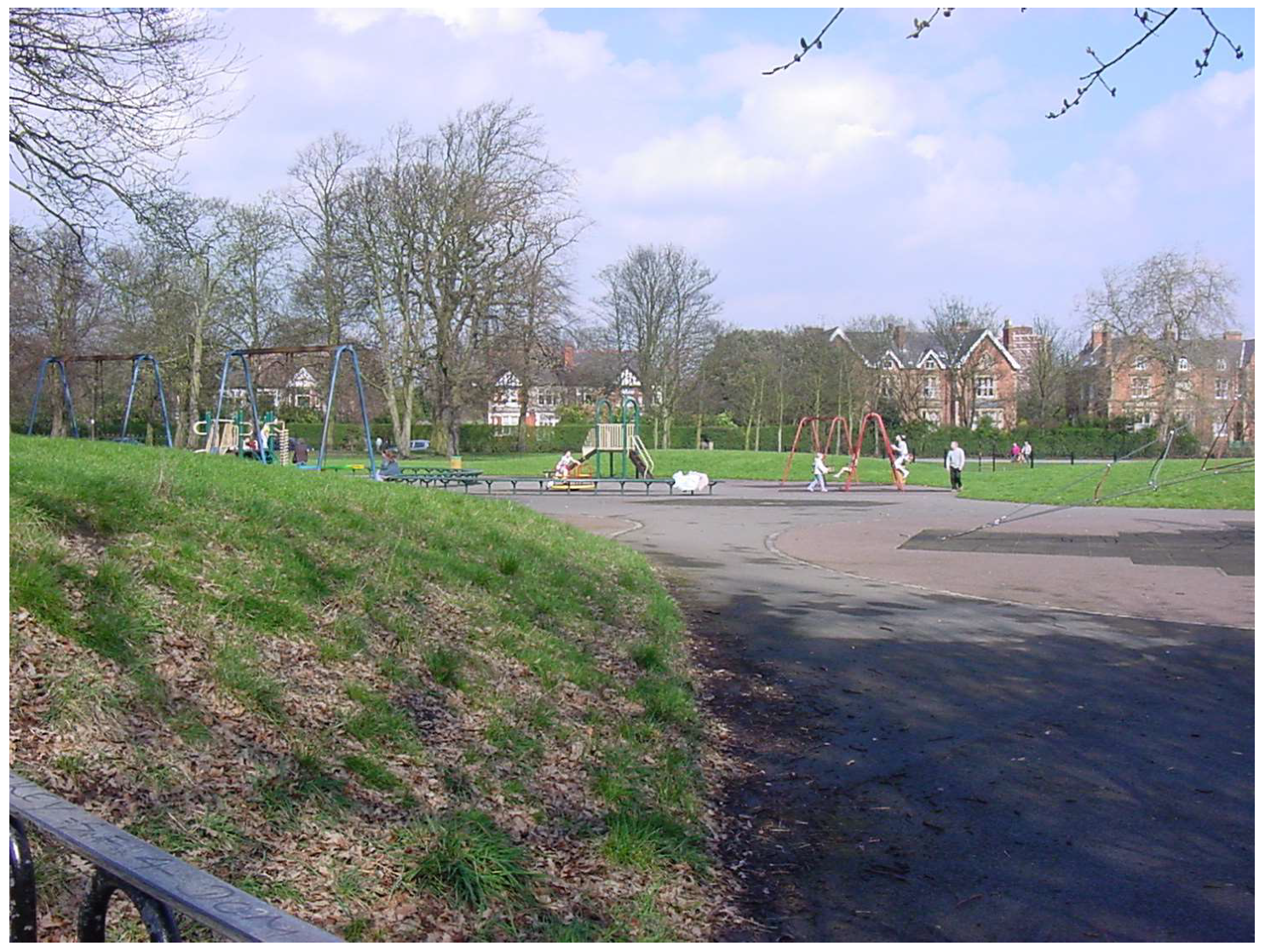
There are moments in the development of landscape and urban-design history where one might begin describing the development and current thinking concerning the evolution of landscape urbanism and related concepts. For this discussion, the choice is Birkenhead Park across the Mersey River from Liverpool, England (Figure 1). The park was designed by Joseph Paxton, a blend of landscape designer and architect [1]. This is the park that inspired Frederick Law Olmsted Sr. in the design of Central Park, New York; however, Central Park is clearly delineated between the softscapes of the park and the hardscape of architecture across the street surrounding the park. At Birkenhead Park, the site is a mixture of central softscapes with a periphery of buildings within the site and a circulation system for pedestrians and for carriages. In other words, the boundaries between hardscape and softscape are integrated. This difference often goes unnoticed as authorities typically explore the similarities in the circulation system and softscape features between the two parks.
For many observers, the classification of space and land creates distinct districts such as at Central Park—urban and parkland—but Birkenhead Park is an attempt to integrate the two. While the term landscape architect can be attributed to an adaptation of the French term “architecte paysagiste”; the English term “landscape” architect was first used by Meason in 1828 to describe the integration of architecture and landscape in a picturesque fashion, suitable for painting. Birkenhead Park is a less picturesque but still beautiful attempt to integrate landscape and multiple structures [34]. This type of integration was not new as illustrated in Burley and Machemer [1]; now, however, urban form was being explored in new ways.
The differences between traditional urban design and the evolving landscape-urbanism movement has a parallel in plant ecology. Real, L.A., and J.H. Brown (1991) present papers by both eminent ecologist Frederic Clements (1874–1945) and the great taxonomist H.A. Gleason (1882–1975) [35]. Clements believed that vegetation communities were discrete clustered units, while Gleason suggested that every stand was unique. At the time, conventional wisdom was with Clements; Gleason withdrew back to taxonomy. However, Curtis, McIntosh, and Whittaker provided evidence that Gleason was indeed correct [3,36,37]. The controversy between Clements and Gleason illustrates how science evolves, sometimes bumpy, uneven, and uncomfortable with passionate advocates. The same can be said concerning ideas in planning and design.
In the past, urban designers and some architects interpreted the urban environment in a manner similar to Clements plant-ecology vision (dividing the environment into discrete groups), and some landscape architects interpreted the environment in a manner similar to Gleason, ecologists, and some geographers (seeing the environment less distinctly and more as a continuum from wilderness to the dominating urban architecture and built forms). This does not mean that either is correct or wrong, but rather that the normative values that each broad general group had then drove their perception and organization of space.
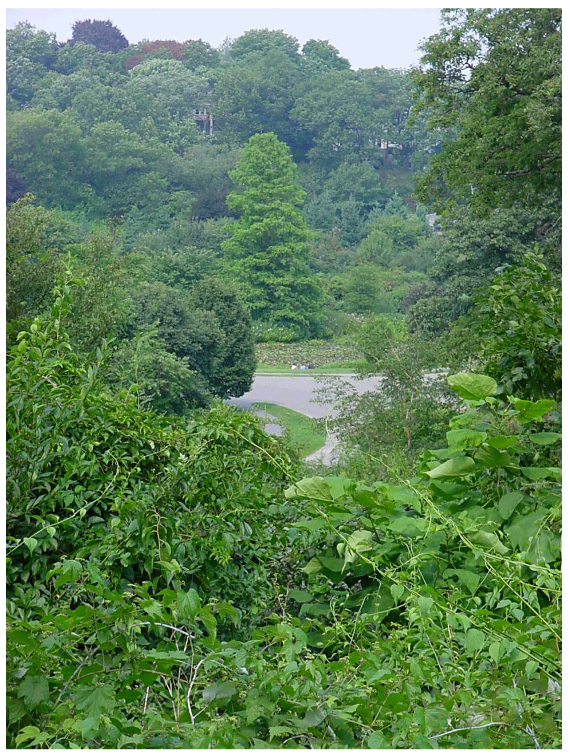
Shortly after the creation of Birkenhead Park, some American urban environments such as in Boston/Brookline, Massachusetts, and Minneapolis, Minnesota saw the development of urban green infrastructure in the form of connected greenways [1,38,39,40]. Individuals such as Frederick Law Olmstead Sr. (1822–1903) and Horace W.S. Cleveland (1914–1900) were concerned with sustainability and the environment long before it became fashionable in current culture. The Emerald Necklace in Boston is a series of connected greenways that began in the late 1870s, designed by Olmsted (Figure 2). The Minneapolis park system contains a complete, citywide, greenway circular park system following lakes, wetlands, creeks, rivers, and boulevards. The system was designed by Cleveland and expanded by others. Every trained landscape architect knows this history and early design precedents because in their training, landscape architects must take a course in the history of their profession, something that is missing in the training of many environmental researchers in many fields at universities, unaware of spatial precedents. Sustainability in the urban environment in the Americas has a tradition that is over 120 years old—surprising to those who believe it is something new.
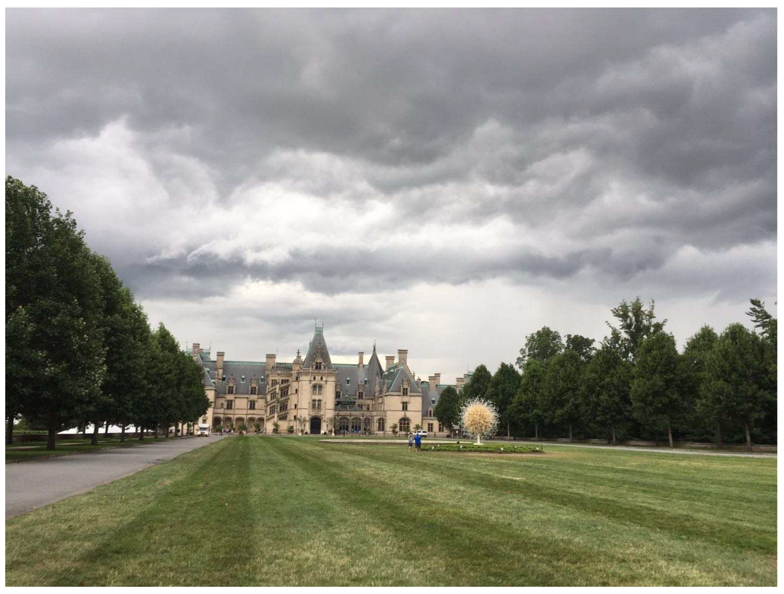
Another important pre-twentieth century project was Biltmore, a massive mansion and estate constructed on the edge of Ashville, Tennessee from 1889 to 1895 [1]. The mansion was built in a French Chateau-esque style with 250 rooms and 35 bedrooms, 43 bathrooms, and 65 fireplaces, and is an example of Beaux Arts architecture. However, it is in the landscape where thoughtful planning and design occurred. Olmsted developed a bass pond as an erosion-control sediment pond to catch the extensive soil erosion occurring during site development. Scientific forestry coalesced as a profession through the estate’s lands. The various land uses on the estate were assigned by examining the suitability of various portions of the landscape to support various agricultural functions. This was at a time when George Perkins Marsh had written Man and Nature (1864), describing the extensive erosion from the deforestation of hills in Turkey and the filling of ports with sediments [1,41]. Responses to develop thoughtful land management and sustainability in the Americas was much earlier than many people in society currently believe. Another feature of Biltmore is the ability of Olmsted to blend the precedents of the French, Italian, and English Landscape Schools, and the American rugged landscape, together [1]. It reflects how some landscape architects think about design across broad areas, where various styles (normative theories) can be integrated (Figure 3). Like Biltmore (an environment larger in area than many cites), a city is a composition of many things: local vernacular, city beautiful/classic, modern, postmodern, functional and industrial engineering, lost space, urban decay, and natural remnants and features. These land uses in the city require organization just as Biltmore was thoughtfully organized.
After this era, advances in the art of planning and design were at a standstill (so much had been accomplished from the 1850s until the 1900s), with many landscape architects designing estates following Beaux Arts norms. Even in 1946, with the exception of a few modernist landscape architects such as James Rose, Roberto Burley Marx, Thomas Church, Dan Kiley and Garrett Eckbo [1], the typical curriculum included standard topics illustrated by Halligan in 1946, focusing upon site design that did not deviate much from the concepts of Andrew Jackson Downing, 100 years earlier [42].
However, in subdivision design, changes were emerging from the early experiments of Olmsted at Riverside, Illinois, and Alermin Hitchkoss (1816–1903) at Lake Forest, Illinois [1]. These subdivisions followed the precedent similar to cemetery design started at Père Lachaise Cemetery in Paris France and continued in the Americas with Mount Auburn Cemetery in Massachusetts, containing characteristics reminiscent of Paxton’s Birkenhead Park with winding carriageways fitting into the landscape [1]. Suburban design advanced with the development of such projects as Radburn, New Jersey by Clarence Stein (1882–1975) and Henry Wright (1878–1936) with cluster housing, redefined public space, and safe walkable pedestrian ways to schools and shopping areas, and Greenbelt, Maryland by Hale Walker and Harold Bursley with its affordable housing and green open space [1]. Yet, after World War II, many communities were planned and designed without regard to these more sustainable and safe design precedents.
While advances in site design were somewhat at a standstill, there was going to be a formative change in the sciences from the 1930s to the 1960s [1]. The works of Aldo Leopold (1887–1948) at the University of Wisconsin developing the science of Wildlife Management and publishing Game Management in 1933 exemplify this change [43]. Investigations in natural history, environmental science, agriculture, social science, building technology, and engineering began to be substantial. By the 1960s, individuals such as Ian McHarg could rely upon the knowledge published in Ecological Monographs to assess the landscape for building suitability of barrier islands along the Atlantic coast [44]. Knowledge about the effects of Dichlorodiphenyltrichloroethane (DDT) upon American robins (Turdus migratorius L. 1766) at Michigan State University aided Rachel Carson in her writing of Silent Spring [45]. Science had evidence to guide/shepherd the normative theories on planning and design. The combination of modernism, where each design is unique, responding to the qualities and needs of site, client, and users, all driven by the design concept to give form to solutions with the environmental/ecological movement, gave rise to new solutions in both architecture and landscape architecture [1,46].
An important event in the classification of urban space was conducted by Brady et al., but seems to have often gone unnoticed [47]. They studied the urban environment in a manner similar to how Curtis and Whittaker studied woodlands. They could classify suburban environments (buildings less than three stories tall) as urban savanna. Areas with tall buildings were classified as cliff detritus. They discovered that the urban savanna was one of the most productive and diverse environments in their local region [48]. The Brady et al. classification system is very useful when studying built environments across the urban landscape [47]. It represents a new way of thinking about the built environment. Instead of classifying the built environment in terms of its buildings, zoning boundaries, and taxable zones, the environment was classified as an ecological entity that included the activities of humans. There now was a way to blend the continuum of naturalistic landscape settings with the urban landscape in an ecological manner and represent this continuum with maps. Thirty years later, Ellis et al., in 2013, produced a map of Earth representing a version of this continuum, naming the map series the Anthropogenic Biomes of the World [49]. The maps blends the environmental character of both nature and humans.
Mapping and classifying space has often been a challenge. Maps often contain lines and divisions, creating regions and subsets. These maps were often created with the impressions and experience of senior academics and scholars who were widely traveled, observing many conditions and settings. Often these maps are accepted without much controversy—after all, they were all created by authorities on the topic. However, methods in statistical geographical data analysis facilitated understanding the composition and clustering of homogeneous spatial units into groupings on maps, and removed some of the subjectivity associated with classification.
An article by Qi et al. in 2012 illustrates this problem in classifying the environment. When humans draw maps of regions, they often have preconceptions in drawing the maps [50]. Regions are often of similar size, and each region is typically continuous. Yet the maps composed with data ordinated by the computer may be considered to contain fewer biases. Qi et al. discovered that, when studying the spatial distribution of trees in Michigan, there were discontinuous homogeneous regions, large patches of regions within regions, and the size of these regions greatly varied [50]. In addition, some of the data suggested that Michigan was actually part of just one region dominated by the distribution Ulmus americana (American elm), a tree of limited economic importance, often considered a weed tree, and of limited botanical interest when compared to other more interesting trees. But the computer has no bias against American elm, and the data suggested the distribution of this tree could classify the whole state into one set. When Qi et al. employed the significant dimensions of the tree-distribution data into sets and groupings, a highly complex map of the regions of Michigan was produced [50]. This map was not similar to any other map produced by experts. Each map varied in many significant ways. So which map over the various attempts to classify the regions is correct? The situation remains unresolved and illustrates the problem when constructing maps and classifications of a landscape. The data from Qi et al. even suggests that each space is somewhat unique, flowing along several dimensional continuums [50]. A concept that is not that different than the findings of Curtis (1959) and Whittaker (1975), where each stand and setting is unique [36,37].
The emergence of landscape ecology in the 1980s, and the maps generated to study the environment, prompted much enthusiasm. This history may be the most well-known literature by the readership of this journal and so it is not presented in this essay. One of the premises of landscape ecology is that the shapes and patterns of homogeneous environmental units influence the use and suitability of space. There was a belief that certain shapes and patterns are more beneficial than other shapes and patterns. However, as these shapes and patterns were examined, it was discovered that one shape and pattern, advantageous to one group of organisms, was equally disadvantageous to another group of organisms. There is no such thing as a universally beneficial pattern. In addition, it is important to note that landscape ecology (studying shapes and patterns) is not the study of the ecology of landscapes, something that is confused and misrepresented by many who study natural history. Indeed, the study of the ecology of landscapes and landscape ecology are inter-related, but geographers and many who study landscape ecology understand this difference and distinction. The field of landscape ecology continues to evolve and grow as investigators explore these shapes, patterns, and relationships.
The problem concerning discovering and devising planned, built, and managed landscape patterns can be explained by examining the habitat-suitability models developed by the United States Fish and Wildlife Service (USFWS). These models were developed by experts to predict species-specific habitat suitability. Upon examination of these models, each wildlife type required a different combination of spatial contents and, at times, different spatial patterns. In other words, each species required a different set of environmental conditions. This implies that a wide variety of patterns and combinations, almost infinite in expression, are necessary to support all organisms on the planet. Early attempts to explore planning and design applying these models, occurred in the late 1980s [51,52]. By 2003, Burley, on-site in Colorado, illustrated that, at best, these models may be able to explain only about one-third of the variance in predicting multispecies preferences for environments [53]. The result means that the universal (best) pattern is a set of nonuniversal patterns, and there is still much that can be learned and discovered in the natural world. This problem concerning optimal design can seem quite contrary to planners and designers who search for solutions to create the best possible spatial conditions. But this mindset to find the best spatial organization originates with designers who are working with sites. Landscape ecologists, geographers, and landscape architects often explore settings and solutions across sites, where the optimal known solution for one site is different from another site.
Ideas about forms, patterns, and designs were going beyond the Euclidean/Cartesian perspective. Fractal geometry was invented several hundred years ago in Italy, but gained momentum in the 1980s, as illustrated by Barnsley and Gleick [54,55]. This approach revealed that spatial values between the whole numbers of 0, 1, 2, and 3, were possible, and the range of values between these whole numbers was infinitely large. Fleurant et al. in 2009 demonstrated how the fractal numbers of individual tree species could be replicated with the box-counting method to generate planting designs for reforestation on large surface mine, plus replicate patterns of lakes and hilltops on the reclaimed landscape [56]. Yue and Burley were able to replicate the general patterns of a traditional Chinese garden in site design by applying fractal studies [57]. Wei, Fleurant, and Burley were able to replicate the patter of buildings on an island in Hong Kong by applying a similar box-counting method [58]. No longer was the framework of Lynch (1960) the only framework possible. Alberti (2009:268) recognized the limitations of Lynch’s framework and has called for new and fresh interpretations [59] (p. 268). Applying fractal technology was one of these new interpretations. Many of these fractal objects do not even have names for the different sets and types of fractals. It is easier to say what they are not, or what they are between, than actually define them. In the future, someone may redefine the image of the city with a fractal vocabulary or a new mathematical paradigm.
The combination of a relatively long history in sustainability and green infrastructures, and the ability and skill to read the environment to create new combinations and patterns in built form poised landscape architectures to develop a landscape-urbanism perspective. There was only one thing missing: the experience and ability to plan extensive urban environments. In the 1920s, architects and landscape architects created the urban-planning profession to address the planning of the urban environment [1]. Landscape architects worked with large landscapes, such as national parks and forests, but not necessarily the complete urban environment to form a city. Instead they would work on the design of pieces (sites) or parts of networks. Warren Manning, a landscape architect, worked on a national plan for the nation, but such work was the exception. After World War II, the profession of urban planning drifted towards social and economic planning [1]. Many urban planners could not draw, or design like landscape architects could. Some firms in the United States started employing landscape architects to conduct landscape-planning studies. For example, Eckbo, Dean, Austin, and Williams (EDAW—the “E” in EDAW is for the late Garrett Eckbo, a landscape architect) were hired to produce a comprehensive land-use plan for the whole state of Hawaii [1]. The landscape architects filled the void that was left by American urban planners. Instead of just being a primarily design profession, landscape architecture became a planning and design profession. It was a natural fit but unforeseen 40 years earlier. This was the final skill and ability necessary that led to the rise of landscape urbanism by primarily the landscape architectural community.
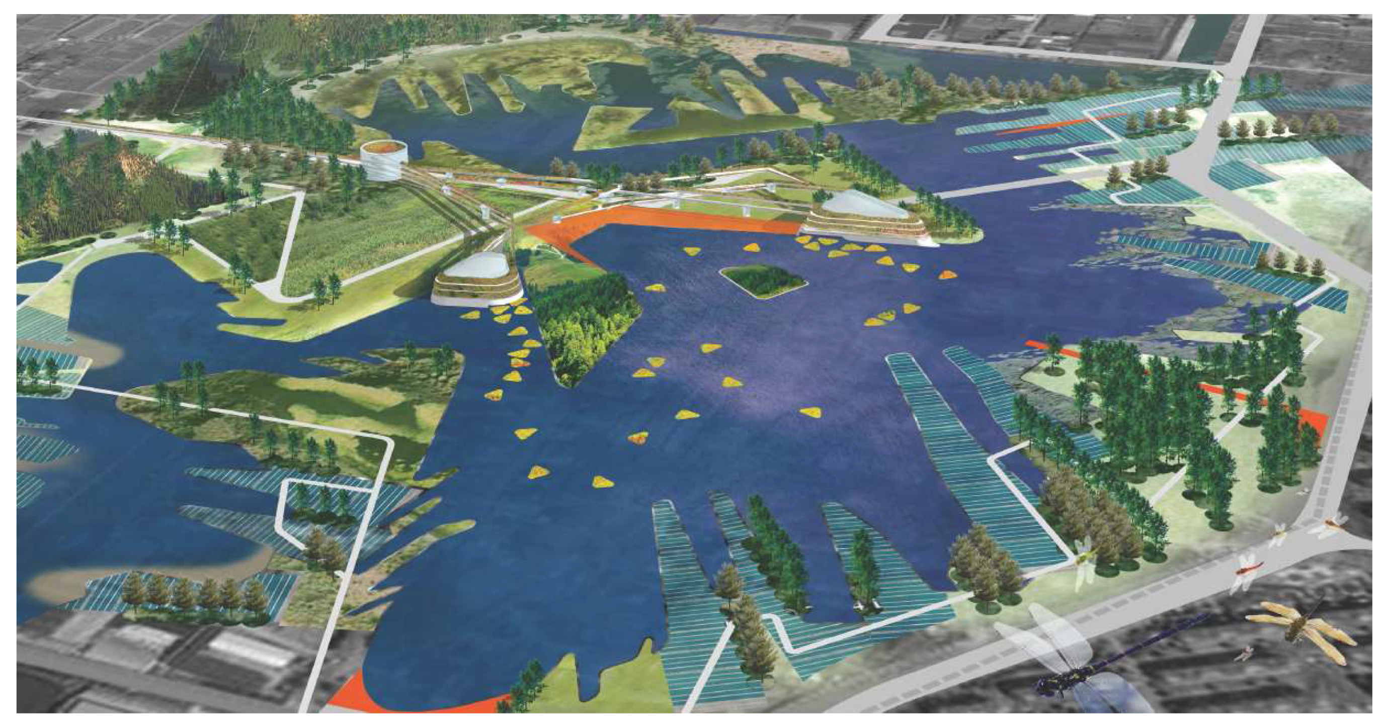
Landscape architects explored a different approach in urban form, an approach known as “Landscape First” (as opposed to architecture/circulation first (Figure 4) [1]. In architecture/circulation first, streets are organized, then buildings are placed in the spaces between the building, and green space is then set around a structure as an ornamental feature. In landscape first, the needs of the environment are initially considered—similar in thinking to McHarg in 1969 and Lewis in 1996, so the idea is not necessarily new [44,60]. Circulation is composed to accommodate the needs of the environment. Finally, structures are placed in this setting. It is a very different way of thinking about design and form. Many landscape architects are trained to think this way, and this kind of thinking is illustrated in the works of James Hawks Jr. [61]. In land development, James Hawks Jr. would be the first to explore its possibilities for a client, organizing the landscape to perform ecological services, develop a circulation pattern, and then placing potential structures. Architects and engineers would be involved in the project, but Jim was involved from the start to the end of the project. Dr. Binyi Liu, a professor at Tongji University in Shanghai, has been influential in designing a truly landscape-first project, Jiyang Eco-Park, and has lectured on the subject [1]. Sometimes, this approach has been affiliated with post-postmodernism and landscape urbanism.
Critics of the landscape-urbanism movement have noted that some projects in places like New York City are only site projects or connective linear systems, but it takes time to completely influence and affect a previously developed urban area. Jiyang Eco-Park is an example of a more complete landscape-urbanism-like project.
To create a landscape-first environment implies that one has an understanding of the natural world in relationship to the built form. This is not an easy task. There are numerous good readings on urban ecology, such as McDonnell, Hahs, and Bruste; Marzluff, Shulenberger, Endlicher, Alberti, Bradley, Ryan, and Simon; and Berry and Kasarda [62,63,64].
However, reading such informative material, one could still be perplexed about what to do. How to apply this information? The problem is that knowing is not the same as being able to do. Contributions such as Ecological Urbanism attempt to bridge this knowledge with essays and project examples [65]. Still, understanding how to apply ecological knowledge is often not easy.
Coinciding with the landscape-first movement, post-postmodernism/context-sensitive design was emerging, as described by Turner (1995) and promoted by transportation landscape architects [1,66]. It is a movement that considers culture, function, ecology, economics, and aesthetics in unison. Good projects consider all five issues together [1]. In contrast, modernism and postmodernism primarily explored the program items’ function and aesthetics with different and varying normative theories. Modernism permeated all of the professions. Postmodernism was most expressive in the fine and performing arts, and architecture. The music and films of the French late Serge Gainsbourg (1928–1991) exemplified the postmodern movement [1]. In many respects, the landscape-first and post-postmodernism/context-sensitive design movements are normative theories with similar overlapping thinking.
It was this intellectual setting that led to the landscape-urbanism perspective being first used as a term in Australia and quickly found members who agreed with this general approach. The landscape architectural community could find much to agree with this perspective. This perspective looked at the urban setting as a series components and compositions similar to how one thinks about the contents of naturalistic settings, composed of history, objects, organisms, functions, relationships, often without firm divisions, lines, and edges. The contents can be mixed and combined in endless configurations, and flow from one unique setting to another, just as in the natural world. Like fractal geometry, landscape urbanism transcends scale. This is not to say that landscape urbanism must be designed with fractal geometry, but rather landscape urbanism contains fractal-geometry components. It is more than just the whole-numbers perspective of Lynch.
Classifying the works of designers, and understanding terms and variations in normative theory can be a messy business and it has arrived to the landscape-urbanism community. What it is and what it is not has generated much debate, as has the vocabulary of terms. Newton, back in 1951, brought some common sense to the debate [67]. He said:
Frankly, I believe it most unfortunate, in a way, that we should ever have found the term ‘modern’ at all necessary in application to design. One day not long ago a well-known architect was asked by a well-meaning dowager, ‘Oh, Mr. So-and-so, you’re a modern architect, aren’t you?’ To which the architect replied, ‘Madam, if I were a surgeon, would you ask me if I am a modern surgeon?
He goes on to further state: “Whoever wishes to reach new conclusions would do well to examine and revise the premises, the assumptions, the foundations upon which he has built his understanding, for the chances are that what he needs, more than anything else, is a whole-hearted reorientation of his basic attitude.” When one reads this book, one almost gets the impression he could be discussing landscape first, post postmodernism, and landscape urbanism. Newton (1951:2–3) states:
I would call it the notion of togetherness. According to it, the events of our world, in whatever form they appear to us, are to be seen as inter-related, interconnected always in some way to some degree. The degree may be great or it may be small, but nonetheless it suggests that we would wisely be ever alert to seeing things not as isolated separates but as different aspects of some joint or common phenomenon.
Such a statement applies to landscape urbanism. Landscape urbanism is still in its formative stages. It takes time to build cities that are expressive of landscape-urbanism ideals. It took time to build cities that have city-beautiful components, and these cities are still under development (such as Chicago and Washington, DC), adding features and civil structures. Finally, there is no guarantee that this movement, emerging primarily from the landscape architectural community, will make any significant contributions to truly improve the broad urban setting beyond a few interesting projects. It is too early to tell.
4. Conclusions
Like any idea, landscape urbanism is expressed in many forms and normative theories. Not everyone agrees. There has been an explosion of literature on the topic, just as there was at one time for modernism and for the short-lived postmodern movement. Even today, there are still many modernists and some postmodernists. But now, there are post-postmodernists, and some of them are embracing the ideas of landscape urbanism, or they may be one and the same. The story of this movement is just beginning. It remains to be seen if landscape planners/designs and the intellectual perspective about the environment emerging from ecologists can create a better urban setting.
This essay explains through the eyes of an ecologist/landscape architect how humankind arrived at this moment. It is unclear what will happen next and how long this movement will last. However, in the forthcoming years and decades, there may be numerous schools of thought on the subject, and numerous built projects expressing the normative theories associated with landscape urbanism, and how it relates to movements in sustainability and the discipline of landscape ecology.
Funding
This research received no external funding.
Conflicts of Interest
The author declares no conflicts of interest.
Appendix A
A strong body of the criticism literature in landscape architectural planning and design is missing within the profession. Bruce Sharky, a professor at the Louisiana State University, produced a series of volumes concerning landscape criticism of built works [68,69,70,71]. The volumes are excellent examples of landscape criticism.
Chronological criticism is a form of historical criticism often employed in antiquity studies, such as interpreting the Bible. In historical criticism, the investigator examines the origins and interpretations of ancient texts for intended meaning and historical context. This approach to criticism has been around for about four centuries. It can be used in interpreting the origins of ideas and their evolving development [1]. The well-known works of Bronowski and Burke are popular forms of chronological criticism [72,73].
Chronological criticism is the general form of criticism employed in this essay. The essay examines a time period from early built form to the ideas of the present concerning landscape urbanism.
It should be noted that the historical context of much of what has been developed and evolved is missing in the education of many professions. New ideas to one branch of study is an old idea to another. The focus of much current education concerns immediate practical information with no wisdom in the understanding of context. Supposedly the literature review is supposed to compensate for this immediacy, yet it often focuses upon recent advances without recognition of historical precedence. Often, there is a rush to claim new knowledge. At times, historical understanding is considered unimportant. Such a condition exists for some with the topic of landscape urbanism. Chronological criticism can provide a venue to explain its development and context.
Appendix B
The essay is from the view of a landscape architect (a member of the American Society of Landscape Architects (ASLA) for 36 years and a fellow in this society (for his research accomplishments)), who is also an ecologist (a member of the Ecological Society of America (ESA) for 36 years, a life member, and has been at times a certified ecologist) and a registered landscape architect for 36 years from the United States of America, earning 15 ASLA (state/national)/American Institute of Architects) (state) awards for writing, designed projects, and research. The author was the 2005 American Society for Mining and Reclamation researcher of the year—not an easy task when competing with agronomists, foresters, engineers, soil scientists, and hydrologists for such a distinction as a planner and designer. The author has had over 400 articles, book chapters, and abstracts published nearing the end of his career. He recently coauthored a 601-paged book describing the history of landscape architecture/environmental design, having traveled to 48 countries around the world [1]. He has been a Fulbright scholar in Portugal in 2003, and a research scholar funded by the French government in 2011–2012, stationed at Agro-campus Ouest, Angers, France, part of the Rennes University system. The author has been teaching in higher education for nearly 42 years, including landscape history, planning, and design theory, and research methods. These are the basic credentials of the author writing this essay, providing a background of experiences and scholarly achievements to create the criticism.
References
- Burley, J.B.; Machemer, T. From Eye to Heart: Exterior Spaces Explored and Explained; Cognella Academic Publishing: San Diego, CA, USA, 2016; ISBN 978-1-63487-685-8. [Google Scholar]
- Lang, J. Creating Architectural Theory: The Role of the Behavioral Sciences in Environmental Design; Van Nostrand Reinhold: New York, NY, USA, 1987; ISBN 10: 0442259816. [Google Scholar]
- Curtis, J.T. Vegetation of Wisconsin: An Ordination of Plant Communities; University of Wisconsin Press: Madison, WI, USA, 1959; ISBN 10: 0299019403. [Google Scholar]
- Ashby, E. Statistical ecology. II—A reassessment. Bot. Rev. 1948, 14, 222–234. [Google Scholar] [CrossRef]
- Binford, L. Constructing Frames of Reference: An Analytical Method for Archaeological Theory Building Using Ethnographic and Environmental Data Sets; University of California Press: Berkeley, CA, USA, 2001; ISBN 10: 9780520223936. [Google Scholar]
- Bateson, G. Mind and Nature: A Necessary Unity; Dutton: Boston, MA, USA, 1979; ISBN 10: 0525155902. [Google Scholar]
- Boyer, C.B. A History of Mathematics; John Wiley and Sons, Inc.: Hoboken, NJ, USA, 1968; ASIN B01JXTI8N4. [Google Scholar]
- Doczi, G. The Power of Limits: Proportional Harmonies in Nature, Art and Architecture; Shambhala: Boulder, CO, USA, 1981; ISBN 10: 1590302591. [Google Scholar]
- Lynch, K. The Image of the City; MIT Press: Cambridge, MA, USA, 1960; ISBN 10: 0262620014. [Google Scholar]
- Trump, D.H. Malta: Prehistory and Temples (Malta’s Living Heritage); Midsea Books: Santa Venera, Malta, 2002; ISBN 10: 9990993947. [Google Scholar]
- Burley, P. Stonehenge as above, So Below: Unveiling the Spirit Path on Salisbury Plain; New Generation Publishing: London, UK, 2014; ISBN 13: 978-1-910162-77-4. [Google Scholar]
- Burley, J.B.; Kopinski, E. Villa Lante: Italy’s greatest renaissance garden. Mich. Landsc. 2014, 57, 27–30. [Google Scholar]
- Casault, J.; Burley, J.B. Restored Versailles: A French Garden with a message. Mich. Landsc. 2010, 53, 37–42. [Google Scholar]
- Monsma, J.; Miller, T.; Burley, J.B. The Hidden Meanings and Metaphors of Stourhead: England’s Premier Informal Garden. Mich. Landsc. 2011, 54, 50–57. [Google Scholar]
- Morgan, M.H., Translator; Vitruvius: The Ten Books of Architecture; Dover Publications, Inc.: Mineola, NY, USA, 1960; ISBN 10: 9780486206455.
- Tulay, A.S.; Akat, H. Didyma Miletos Priene; Touring and Automobile Association of Turkey: Istanbul, Turkey, Unpublished work.
- Mert. Pamukkale Hierapolis-Aphrodisias; Mert Basim Yatin Dağitim Ve Reklamcilik Tic Ltd. ŞTİ: Istanbul, Turkey, 2004. [Google Scholar]
- Scully, V., Jr. The Earth the Temple and the Gods: Greek Sacred Architecture, revised edition; Yale University Press: New Haven, CT, USA, 1979; ISBN 10: 0300023979. [Google Scholar]
- Orlandini, A. Un Architecte/Une Œuvere: Le Parc de la Villette de Barnard Tschumi; Somogy Éditions d’Art: Paris, France, 2001. [Google Scholar]
- Secundus, G.P. Natural History: A Selection, reprint edition; Penguin Classics: London, UK, 1991; ASIN B0092GDQSQ. [Google Scholar]
- Strabo of Amaseia. Delphi Complete Works of Strabo—Geography; Delphi Classics: East Sussex, UK, 2016; ASIN B01JK0KODS. [Google Scholar]
- Watts, M.T. Reading the Landscape of America: An Adventure in Ecology; Macmillan: London, UK, 1957; ASIN B0006AUYYG. [Google Scholar]
- Grese, R.E. Jens Jensen: Maker of Natural Parks and Garden; John Hopkins University Press: Baltimore, MD, USA, 1992; ISBN 10: 0801842875. [Google Scholar]
- Hearn, M.F. (Ed.) The Architectural Theory of Violet-le-Duc: Readings and Commentary; The MIT Press: Cambrdige, MA, USA, 1990; ISBN 10 0262220377. [Google Scholar]
- Jin, Y.; Burley, J.B.; Machemer, P.; Crawford, P.; Xu, H.; Wu, Z.; Loures, L. The Corbusier dream and Frank Lloyd Wright vision: Cliff detritus vs. urban savanna. In Urban Agglomeration; Ergen, M., Ed.; Intech: Rijeka, Croatia, 2018; pp. 211–230. [Google Scholar]
- Burley, J.B.; Deyoung, G.; Partin, S.; Rokos, J. Reinventing Detroit: Grayfields—New metrics in evaluating urban environments. Challenges 2011, 2, 45–54. [Google Scholar] [CrossRef]
- Aguar, C.; Aguar, B. Wrightscapes: Frank Lloyd Wright’s Landscape Designs; McGraw-Hill Professional: New York, NY, USA, 2002; ISBN 10: 0071377689. [Google Scholar]
- Wall, T.U.; McNie, E.; Garfin, G.M. Use-inspired science: Making science usable by and useful to decision makers. Front. Ecol. Environ. 2017, 15, 551–559. [Google Scholar] [CrossRef]
- Safford, H.D.; Sawyer, S.C.; Kocher, S.D.; Hiers, J.K.; Cross, M. Linking knowledge to action: The role of boundary spanners in translating ecology. Front. Ecol. Environ. 2017, 15, 560–568. [Google Scholar] [CrossRef]
- Cranz, G. The Politics of Park Design: A History of Urban Parks in America; The MIT Press: Cambridge, MA, USA, 1982; ISBN 10: 0262530848. [Google Scholar]
- Gothien, M.L. A History of Garden Art; Wright, W.P., Ed.; Archer-Hind, J.M., Translator; Dent and Sons Limited: London, UK; E.P. Dutton and Co, Ltd.: New York, NY, USA, 1928. [Google Scholar]
- Foucault, M. The Archaeology of Knowledge; Sheridan, A.M., Translator; Routledge Classics: Abingdon, UK, 2002; ISBN 10: 0415287537. [Google Scholar]
- Foucault, M. Michel Foucault: Aesthetics: Essential Works of Foucault 1954–1984: Volume 2; Faubion, J.D., Ed.; Penguin Books: Londong, UK, 2000; ISBN 10: 9780140259544. [Google Scholar]
- Meason, G.L. On the Landscape Architecture of the Great Painters of Italy; RareBooksClub.com: Peterborough, UK, 2012; ISBN 10: 1236450248. [Google Scholar]
- Real, L.A.; Brown, J.H. (Eds.) Foundations of Ecology: Classic Papers with Commentaries; University of Chicago Press: Chicago, IL, USA, 1991; ISBN 10: 9780226705941. [Google Scholar]
- Curtis, J.T.; McIntosh, R.P. An upland forest continuum in the prairie forest border region of Wisconsin. Ecology 1951, 32, 476–496. [Google Scholar] [CrossRef]
- Whittaker, R.H. Communities and Ecosystems, 2nd ed.; Macmillan: London, UK, 1975; ISBN 10: 0024273901. [Google Scholar]
- Pregill, P.; Volkman, N. Landscapes in History: Design and Planning in the Eastern and Western Tradition, 2nd ed.; John Wiley and Sons, Inc.: Hoboken, NJ, USA, 1999; ISBN 10: 0471293288. [Google Scholar]
- Newton, N.T. Design on the Land: The Development of Landscape Architecture; The Belknap Press: Cambridge, MA, USA, 1974; ISBN 10: 0674198700. [Google Scholar]
- Tobey, G.B., Jr. A History of Landscape Architecture: The Relationship of People to Environment; American Elsevier Publishing Company, Inc.: New York, NY, USA, 1973; ISBN 10: 044400131X. [Google Scholar]
- Marsh, G.P. Man and Nature: Physical Geography as Modified by Human Action; C. Scribner: New York, NY, USA, 1864. [Google Scholar]
- Halligan, C.P. First Principles of Landscape Architecture; Edwards Brothers, Inc.: Ann Arbor, MI, USA, 1946. [Google Scholar]
- Leopold, A. Game Management; Scribner’s: New York, NY, USA, 1933. [Google Scholar]
- McHarg, I.L. Design with Nature; Doubleday/Natural History Press: Garden City, NY, USA, 1969; ISBN 10: 0385055099. [Google Scholar]
- Carson, R. Silent Spring; Houghton Mifflin: Boston, MA, USA, 1962; ISBN 10: 0395075068. [Google Scholar]
- Thayer, R.L. Grey World Green Heart: Technology, Nature, and the Sustainable Landscape; Wiley Series in Sustainable Development; Wiley: Hoboken, NJ, USA, 1993; ISBN 10: 047157273X. [Google Scholar]
- Brady, R.F.; Terry, T.; Eagles, P.F.; Ohrner, R.; Micak, J.; Veale, B.; Dorney, R.S. A typology for the urban ecosystem and its relationship to large biogeographical landscape units. Urban Ecol. 1979, 4, 11–28. [Google Scholar] [CrossRef]
- Burley, J.; Wang, Y.; Loures, L. New Ecologies: Emergence of the Urban Savanna and Cliff Detritus in a Post-modern Era. In New Models for Innovative Management and Urban Dynamics; Panagopoulos, T., Ed.; University of Algarve: Faro, Portugal, 2009; ISBN 978-972-9342-85-4. [Google Scholar]
- Ellis, E.C.; Goldewijk, K.K.; Siebert, S.; Lightman, D.; Ramankutty, N. Anthropogenic Biomes of the World, Version 2, 2000; NASA Socioeconomic Data and Applications Center (SEDAC): Palisades, NY, USA, 2013.
- Qi, J.; Wang, S.; Burley, J.B.; Machemer, T. Defining ecological regions in Michigan based on native tree distributions. Landsc. Arch. 2012, 6, 138–145. (In Chinese) [Google Scholar]
- Burley, J.B. Multi-model habitat analysis and design for M.B. Johnson Park in the Red River Valley. Landsc. Urban Plan. 1989, 33, 261–280. [Google Scholar] [CrossRef]
- Burley, J.B.; Johnson, S.; Larson, P.; Pecka, B. Big Stone granite quarry habitat design: HSI reclamation application. In Proceedings of the ASSMR Conference, Pittsburgh, PA, USA, 19–21 April 1988; pp. 161–169. [Google Scholar]
- Burley, J.B. Habitat modeling: Spatial landscape assessment at the Rigden Mine, Colorado. In Working Together for Innovative Reclamation, Proceedings of a Joint Conference the 9th Billings Land Reclamation Symposium and American Society for Mining and Reclamation, and Reclamation 20th Annual National Conference, Billings, MT, USA, 3–6 June 2003; Barnhisel, R.I., Ed.; ASMR: Lexington, KY, USA, 2003; pp. 103–118. [Google Scholar]
- Barnsley, M. Fractals Everywhere; Academic Press: Cambridge, MA, USA, 1988; ASIN B00E6T1P00. [Google Scholar]
- Gleick, J. Chaos: Making a New Science; Viking: New York, NY, USA, 1987; ISBN 10: 0747404135. [Google Scholar]
- Fleurant, C.; Burley, J.B.; Loures, L.; Lehmann, W.; McHugh, J. Inverse box-counting method and application: A fractal-based procedure to reclaim a Michigan surface mine. WSEAS Trans. Environ. Dev. 2009, 5, 76–89. [Google Scholar]
- Yue, Z.; Burley, J.B. Non-euclidean methods to characterize the Masters of the Nets Garden, Suzhou, China. In Recent Researches in Energy, Environment and Landscape Architecture, Proceedings of the 7th IASME/WSEAS International Conference on Energy, Environment, Ecosystems, and Sustainable Development (EEESD ’11) and Proceedings of the 4th IASME/WSEAS International Conference on Landscape Architecture (LA ’11), Angers, France, 17–19 November 2011; WSEAS: Madison, WI, USA, 2011; pp. 122–128. [Google Scholar]
- Wei, S.; Fleurant, C.; Burley, J.B. Replicating fractal structures with the reverse box counting method—An urban South-east Asian example. In Peer Reviewed Proceedings of Digital Landscape Architecture 2012 at Anhalt University of Applied Sciences; Buhmann, E., Ervin, S., Pietsch, M., Eds.; Wichman: Toledo, OH, USA, 2012; pp. 364–370. [Google Scholar]
- Alberti, M. Advances in Urban Ecology: Integrating Humans and Ecological Process in Urban Ecosystems; Springer: New York, NY, USA, 2008; ISBN 10: 0387755098. [Google Scholar]
- Lewis, P. Tomorrow by Design: A Regional Design Process for Sustainability; Wiley: Hoboken, NJ, USA, 1996; ISBN 10: 0471109355. [Google Scholar]
- Burley, J.B.; Loures, L.; Feng, M.; Hawks, J.W., Jr. ASLA: Polychrome land development in the Upper Midwest. Int. J. Energy Environ. 2012, 6, 415–423. [Google Scholar]
- McDonnell, M.J.; Hahs, A.K.; Bruste, J.H. (Eds.) Ecology of Cities and Towns: A Comparative Approach; Cambridge University Press: Cambridge, UK, 2009; ISBN 10: 9780521861120. [Google Scholar]
- Marzluff, J.M.; Schulenberger, E.; Endlicher, W.; Alberti, M.; Bradley, G.; Ryan, C.; Simon, U. (Eds.) Urban Ecology: An International Perspective on the Interaction between Humans and Nature; Springer: New York, NY, USA, 2008; ISBN 10 0387734112. [Google Scholar]
- Berry, B.J.; Kasarda, J.D. Contemporary Urban Ecology; Macmillan Publishing Co., Inc.: London, UK, 1977; ISBN 10: 0023090502. [Google Scholar]
- Mostafavi, M.; Doherty, G. (Eds.) Ecological Urbanism; Lars Müller Publishers: Baden, Switzerland, 2010; ISBN 10: 3037784679. [Google Scholar]
- Turner, T. City as Landscape: A Post Post-Modern View of Design and Planning; Taylor and Francis: Abingdon, UK, 1995; ISBN 10: 0419204105. [Google Scholar]
- Newton, N.T. An Approach to Design; Addison-Wesley Press Inc.: Boston, MA, USA, 1951. [Google Scholar]
- Sharky, B.; Turner, S.; Womack, W.M. (Eds.) Critiques of Built Works of Landscape Architecture, Volume 1; LSU School of Landscape Architecture, Louisiana State University: Baton Rouge, LA, USA, 1994. [Google Scholar]
- Sharky, B. (Ed.) Critiques of Built Works of Landscape Architecture, Volume 4; LSU School of Landscape Architecture, Louisiana State University: Baton Rouge, LA, USA, 1997. [Google Scholar]
- Sharky, B. (Ed.) Critiques of Built Works of Landscape Architecture, Volume 7; LSU School of Landscape Architecture, Louisiana State University: Baton Rouge, LA, USA, 2001. [Google Scholar]
- Sharky, B. (Ed.) Critiques of Built Works of Landscape Architecture, Volume 8; LSU School of Landscape Architecture, Louisiana State University: Baton Rouge, LA, USA, 2003. [Google Scholar]
- Bronowski, J. Ascent of Man; Little Brown and Company: Boston, MA, USA, 1973; ISBN 10: 0316109304. [Google Scholar]
- Burke, J. Connections, 1st ed.; Little Brown and Company: Boston, MA, USA, 1978; ISBN 10: 0316115816. [Google Scholar]
Figure 1.
View of Birkenhead Park in 2015, a mixture of open space with a variety of active and passive uses, and periphery housing and structures within the park (copyright © 2005 Jon Bryan Burley, all rights reserved and used with permission).
Figure 1.
View of Birkenhead Park in 2015, a mixture of open space with a variety of active and passive uses, and periphery housing and structures within the park (copyright © 2005 Jon Bryan Burley, all rights reserved and used with permission).

Figure 2.
The Emerald Necklace looking toward Brookline, Massachusetts, an example of a greenway, green infrastructure, and the practice of sustainability (copyright © 2004 Jon Bryan Burley, all rights reserved and used with permission).
Figure 2.
The Emerald Necklace looking toward Brookline, Massachusetts, an example of a greenway, green infrastructure, and the practice of sustainability (copyright © 2004 Jon Bryan Burley, all rights reserved and used with permission).

Figure 3.
A view from the French Allée at Biltmore, with the Italian gardens to the left of the trees, the English landscape school to the left of the Italian gardens, and the naturalistic Bass Ponds even farther left leading to a river (copyright © 2018 Xiaoying Li, all rights reserved and used with permission).

Figure 4.
The Qing Ting (Dragon Flies) team’s design applying landscape-first ideas for Chongming Island, Shanghai, P.R. of China (Copyright © 2014 Jason Simms, Marina Kato, Wu Chengyi, Ya Dan, Luo, Han Liu, Hanxiao Jiang, Yiling Chen, used with permission, all rights reserved).
Figure 4.
The Qing Ting (Dragon Flies) team’s design applying landscape-first ideas for Chongming Island, Shanghai, P.R. of China (Copyright © 2014 Jason Simms, Marina Kato, Wu Chengyi, Ya Dan, Luo, Han Liu, Hanxiao Jiang, Yiling Chen, used with permission, all rights reserved).

© 2018 by the author. Licensee MDPI, Basel, Switzerland. This article is an open access article distributed under the terms and conditions of the Creative Commons Attribution (CC BY) license (http://creativecommons.org/licenses/by/4.0/).
Share and Cite
MDPI and ACS Style
Burley, J.B. The Emergence of Landscape Urbanism: A Chronological Criticism Essay. Land 2018, 7, 147. https://doi.org/10.3390/land7040147
AMA Style
Burley JB. The Emergence of Landscape Urbanism: A Chronological Criticism Essay. Land. 2018; 7(4):147. https://doi.org/10.3390/land7040147
Chicago/Turabian StyleBurley, Jon Bryan. 2018. "The Emergence of Landscape Urbanism: A Chronological Criticism Essay" Land 7, no. 4: 147. https://doi.org/10.3390/land7040147
Note that from the first issue of 2016, this journal uses article numbers instead of page numbers. See further details here.