1. Introduction
The Climate and Energy package passed by the European Union (EU) to meet the goals of the Kyoto Protocol with the intention of preventing climate instability, known as the 20 20 20 Plan (Directive 2009/29/EC) [
1], provides for joint action on CO
2 emission levels (−20%), energy production from renewable sources (+20%) and primary energy saving (−20%) by the end of 2020, with a commitment to reduce emissions by 50% to the end of 2050. The outline of these courses of action also specifically considers local and business policies—carbon footprint measurements of products, RET (Renewable Energy Target) incentives, CO
2 compensation through urban forestation, as well as environmental, energy, and climate education and training. These embrace aspects that are deeper than those generically indicated by the environmental and economic policy tools that rely on “command and control logic” and that refer to the compensatory/commercial approach of the Coasian matrix.
The regional energy policy in Sicily is governed by the Environmental Energy Plan of the Sicily Region (
Piano Energetico Ambientale della Regione Siciliana—PEARS) [
2], which identifies wind energy as the best opportunity for Sicily to produce clean energy and reduce pollutant emissions. As a result, planning its use must be optimised, given the high production potential offered by the conformation of the Sicilian territory and its anemometric characteristics. Since these are joint economic, territorial, and landscape issues, there are two main issues that planners and Decision Makers in this sector must address: on one hand, the amount of installed power that Sicily can/must provide, and, on the other, the location/size of the plants.
These topics involve wide ecological and environmental issues that are profoundly affected by the scientific assessment methods and content, precisely because it is impossible to provide evidence for or against this kind of energy production, especially when comparing the overall supply chain with that of fossil fuels. Consequently, opinion on wind energy varies significantly. This opinion is positive if we take a deep long-term ecological view and worry about the progressive shift of environmental and human cost towards the most disadvantaged areas of the planet. It views territorial containment, by companies and homes, and the outcomes of their needs and relative economic performance on the environment and landscape, so that they are “aware” of the effects their lifestyles have [
3,
4].
More restrictive and fundamentally pessimistic views about the possibility of substantially withdrawing fossil fuels, sees the development of wind farms as yet another excuse for needless infrastructure, plundering the territory and violating the “landscape structure” [
5,
6]. This leads to an imbalance between local decisions/negotiation and “broadcasting” with large scale impact, which is done blindly when compared to strategic planning. The financial compensation is insignificant in comparison to the value of the landscape and those who regret its loss after the fact. Financial incentives and compensation introduce new, sometimes distortional [
3], extraneous, and abstract rules about how we relate to the landscape, with the total, personal and collective experience that identifies individuals and communities. These rules are intended to be long-term and linked to the thin thread of delicate balance. Finally, the susceptibility of the political/administrative system to specific interests and corruption completes this critical picture [
7,
8]. The proposed contribution aims to address assessment and planning at a provincial scale, with reference to two different territorial contexts, integrating the set of tools needed to define the plant location models into a descriptive, semantic and syntactic model. The specific objects are:
- -
the descriptive model provides the factual elements useful for wind farm positioning;
- -
the semantic model associates each wind farm with attributes of economic value and landscape; and,
- -
the syntactic model defines the decision rules for the formation of the best territorial allocation layout of wind farms in the two provinces examined.
2. Materials
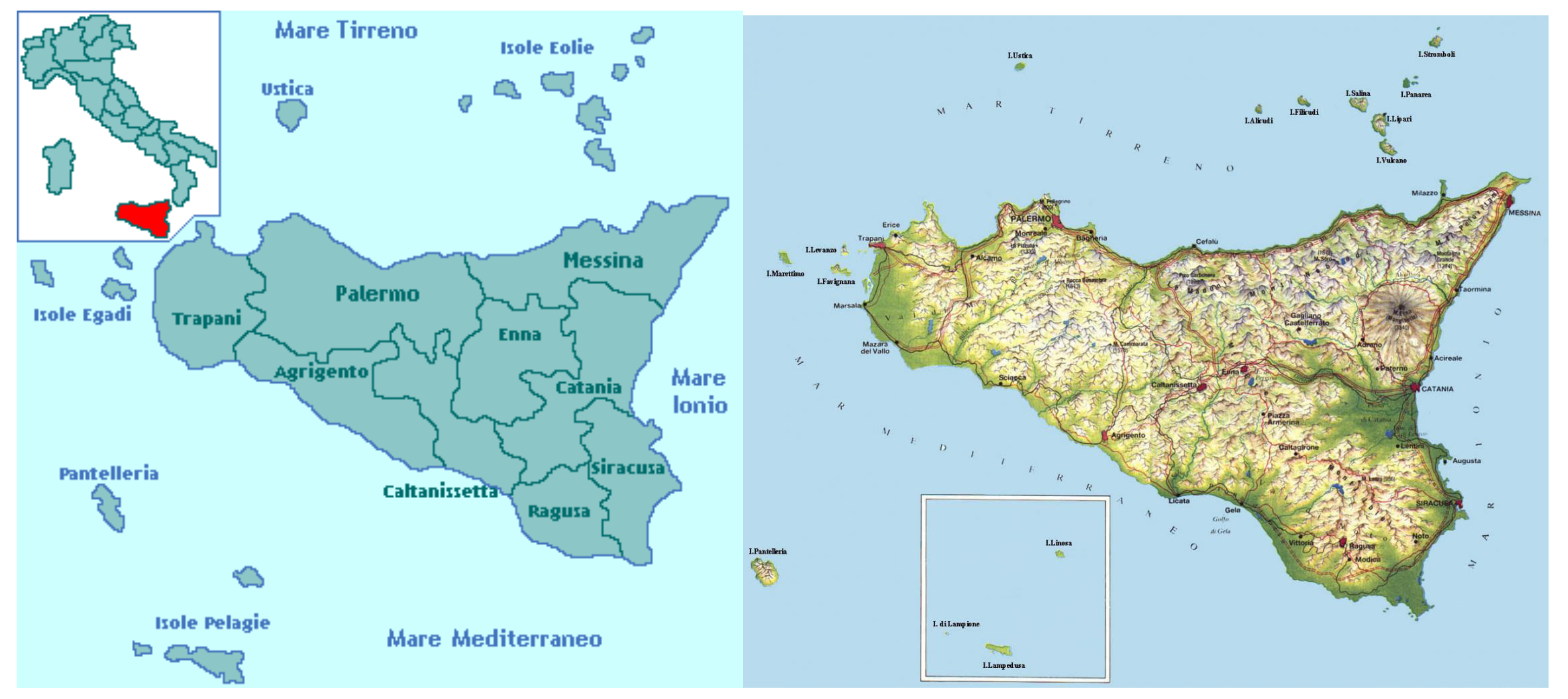
The territories of the two provinces, Enna and Siracusa present wide differences as regards their location in the geographical context, the orography, the degree of anthropization, and the quality of the natural and cultural landscape.
The province of Enna occupies the central part of the island for an area of 2574.7 km
2 and it includes 20 municipalities, with a total population of 168,737 inhabitants [
9].
The province of Siracusa occupies the southeastern part of the island for an area of 2109 km
2 and includes 21 municipalities, with a total population of 400,881 inhabitants [
9].
The result is a considerable difference in population density, 65.5 inhab./km2 Enna versus 190.1 inhab./km2 Siracusa and consequently a different degree of urbanization and infrastructure of the territory.
For these purposes, the structured and rich coastal area in the territory of Siracusa, which attracts investments and tourism, with remarkable impacts on the real estate market prices expectations [
10,
11], differs significantly from the territory of Enna, which is rather introverted and much less rich also from the point of view of wealth capitalized in real estate [
12]; its economy, originally focused mainly on the primary (agricultural, mining etc.) sector, is now growing also in the cultural heritage ones and numerous projects aimed at the territorial restructuring are now in progress [
13].
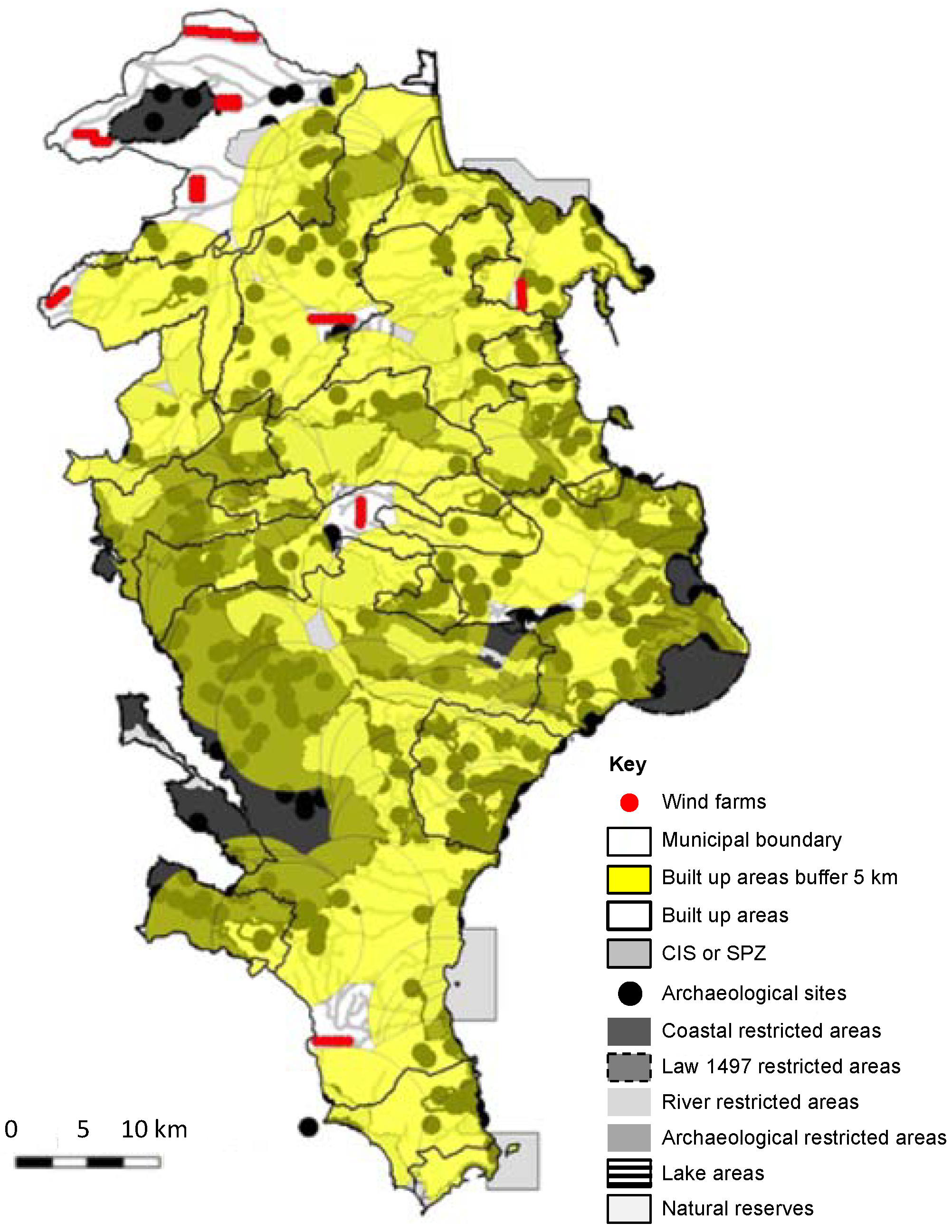
From the orographic point of view the two provinces present significant differences (
Figure 1):
- -
the province of Siracusa is characterized by an extended and jagged waterfront, 447.6 km equal to 89% of the total perimeter of its territory (503.4 km), and a wide flat belt formed in the north by a portion of the alluvial plain of Catania and the Etna lava lands that give life to vast cultivations citrus; to the east a narrower flat belt, densely urbanized, and industrialized; the southern part the coastal landscape is shaped by the action of the sea waters, with the formation of wide marshes, and of the rivers that flow on the wide karst plateau; the central part of the province extends over the Ibleo plateau, a mountain range that was formed by a massive calcareous-marly white conch of the Miocene (Plateau of the Hyblaean); the Ibleo plank has a mainly hilly layout increasing in altitude towards the hinterland to the west, where it is dominated by high reliefs: Lauro Mount (986 m a.s.l), Contessa Mount (914 m a.s.l), Casale Mount (910 m a.s.l), Santa Venera Mount (869 m a.s.l) and Erbesso Mount (821 m a.s.l); some relevant Iblean reliefs are Pancali Mount (485 m a.s.l.) and the Climiti Mounts (416 m a.s.l.) that face the Gulf of Augusta; the Ibleo plateau slopes towards the sea maintaining an average altitude of about 300 m a.s.l.; and,
- -
the province of Enna covers the central part of the island, is the only one in Sicily that has no access to the sea, and is 18 km from the Tyrrhenian Sea to the north, 28 km from the Channel of Sicily to the south, 26 km from the Ionian Sea to East; within its mountainous territory important geographical signs converge, the ridges of the three main mountain ranges of the island, the Nebrodi, the Madonie and the Erei, which were the geographical limits of the three administrative districts during the Islamic and later Norman periods (828–1072), Val Demone, Val di Noto and Val di Mazzara; consequently, on the one hand, the ridges of these three mountain chains are the most suitable locations for the wind farm, on the other, these locations generate the greatest landscape impact both for the extensive intervisibility of the plants and for the interference with the migratory routes of the birdlife; a further aspect that affects the suitability of the location of wind farms is the roughness of the territory that is characterized by the reliefs that dampen the wind speed at low altitude, making it necessary to install higher wind turbines; remarkable mountain reliefs in the province of Enna are: Sambughetti Mount (1558 m a.s.l.) Altesina Mount (1192 m a.s.l.), Rossomanno Mount (885 m a.s.l.), Torre Mount (643 m a.s.l.); the lowest point in the province of Enna is 61 m a.s.l.
3. Methods
The main purpose of this study is the formation of a decision model to support energy policy that is focused on renewable wind power [
14,
15]. In the context of the Sicilian territory, a comparative study is proposed on two provinces of Siracusa (SR) and Enna (EN), highlighting how some significant differences affect the structure of investment planning and the consequent impact on the landscape.
The primary differences between the two provinces concern the natural substratum, i.e., the territory and the windiness, and the cultural contribution, i.e., the complex of the landscape values testifying the equilibrium and the tensions stratified in the millennial adaptation process of the local communities to the natural constraints and opportunities that have influenced the settlements.
The applied approach is divided into three models, a descriptive one, which aimed at selecting the areas suitable for the location of the plants, a semantic one, aimed at evaluating the economic and landscape profile, a syntactic one, aimed at providing the rules for the optimal layout choice of the wind farm policies at the provincial scale.
3.1. Descriptive Model. Selection of the Suitable Plant Areas
The descriptive model combines the characteristics of the territory, contained in the Provincial Territorial Landscape Plans (PPTP), with the rules on the implementation of the wind farms, contained in the PEARS [
16,
17], and it selects the areas suitable for the installments.
The model identifies suitable areas excluding the entire territorial surface:
- -
the 5 km buffer area around each built-up area;
- -
a 500 m bound belt around the archaeological areas;
- -
a 150 m bound zone along or around the water bodies; and,
- -
the Special Protection Zones (SPZ) and the Community Interest Sites (CIS).
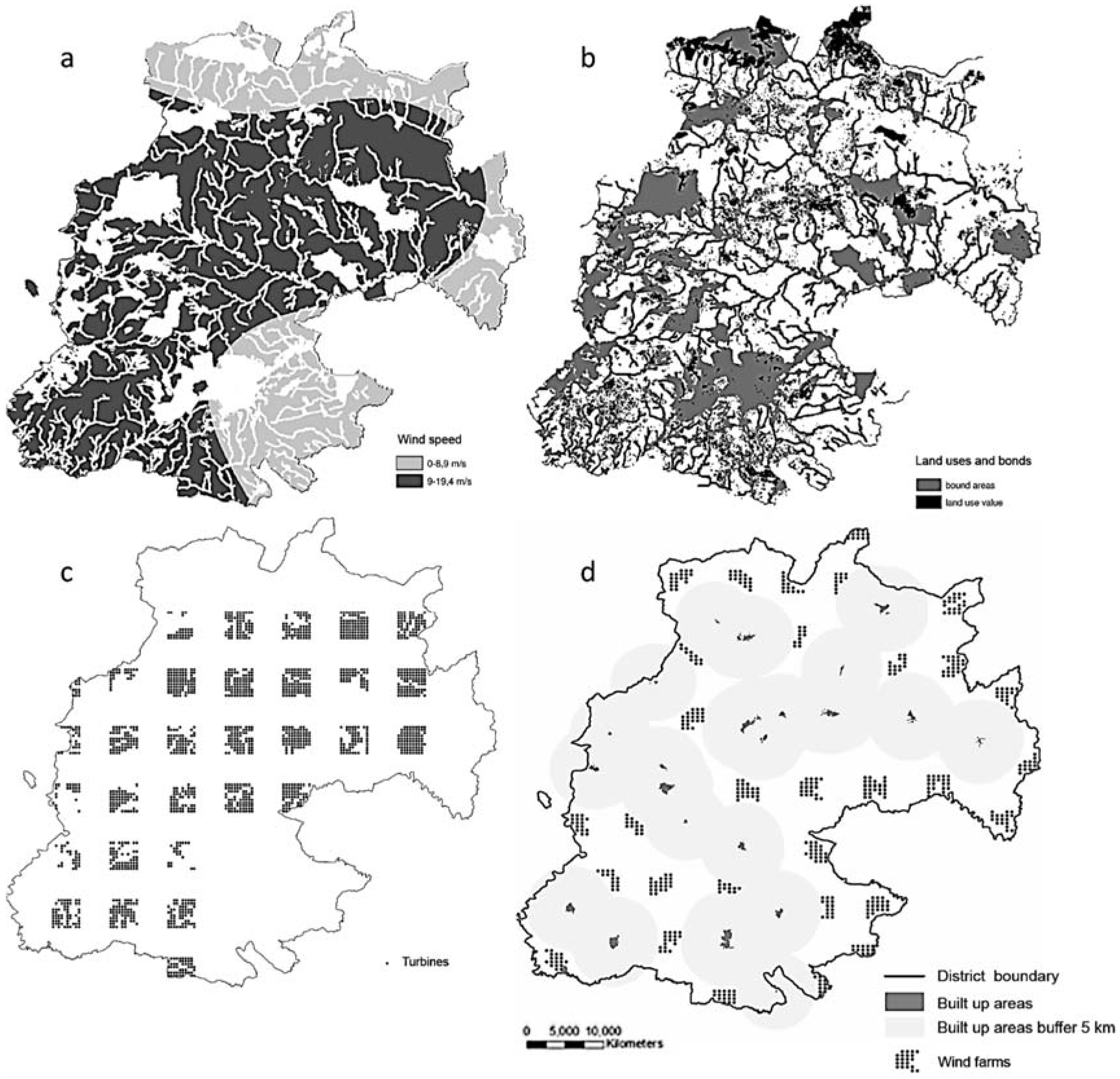
Once the suitable areas were identified, the wind turbines were calculated in these areas, based on the type of wind turbines (80 m hub height 2000 kW), assumed equal for all the sites and for the two provinces; this hypothesis simplifies the study by making comparisons easier; on the basis of the results obtained, the model allows for subsequently optimizing the size of the wind turbines to take into account the best relationship between landscape impact and economic profitability.
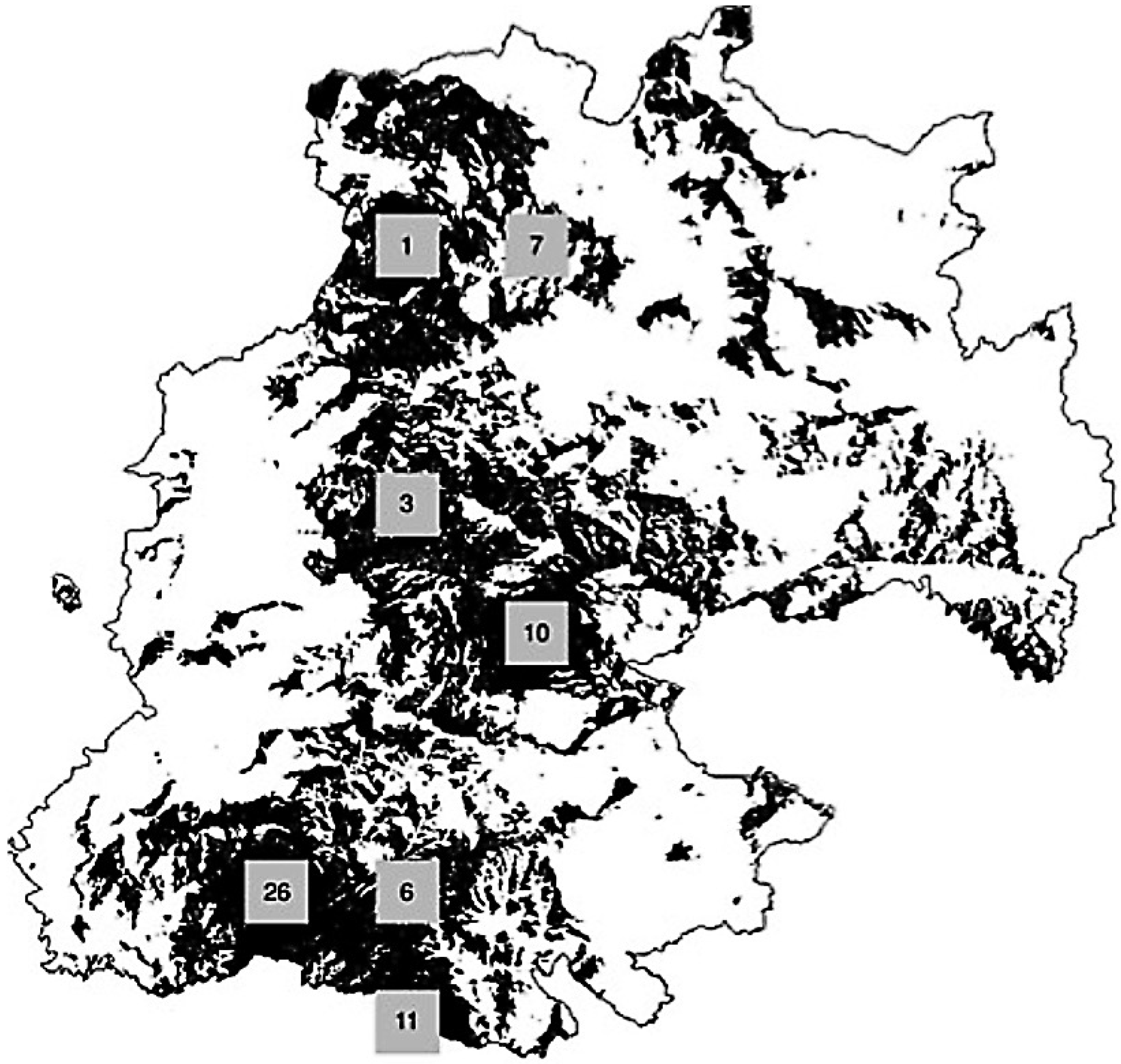
In the province of Enna, where the suitable areas identified are more numerous and more extensive, it has been possible to hypothesize the wind farms layout a 10 × 10 square grid. The PEARS supposes a minimum distance of 4 km between the plant areas, and a minimum distance of 400 m (5 diameters) between the turbines.
In the province of Siracusa, given the small number of areas allowed and their smaller size, the turbines are hypothesized to be located along the roads that cross the plant areas.
3.2. Semantic Model. Economic/Landscape Evaluation
Since these areas, although formally suitable, give rise to plants with a different economic and landscape profile, it has become necessary to evaluate for each of them the economic profitability and the visual impact related to the different windiness and qualitative characteristics of the topographical contexts of reference.
The results of the GIS-based territorial analyses constitute the raw material for the assessment model. In a general sense, this is inspired by the approach of F. Rizzo [
18,
19,
20], which takes the multifold substance that gives value to the creative combination of matter, energy, and information at the level of the three surpluses: 1. Natural (conservational), 2. Bio-Genealogical (evolutional), and 3. Historical/cultural (argumentative). This approach gives rise to judgement criteria that integrate with the design requirements in the “alternative plan design” stage, and specifically: regarding Surplus 1, minimising physical transformation (locating plants near existent road infrastructures) and CO
2 emissions (maximum energy yield per unit of installed power); regarding Surplus 2, maximising the distance from the routes of birdlife; regarding Surplus 3, minimising visual impact with respect to economic convenience, which are respectively qualitative and quantitative measurements of territorial/environmental and social/economic information. Specifically, economic valuation is performed using the main indicators of investment profitability [
21], landscape assessment, based on its visual impact and structure [
22].
3.2.1. Economic Appraisal
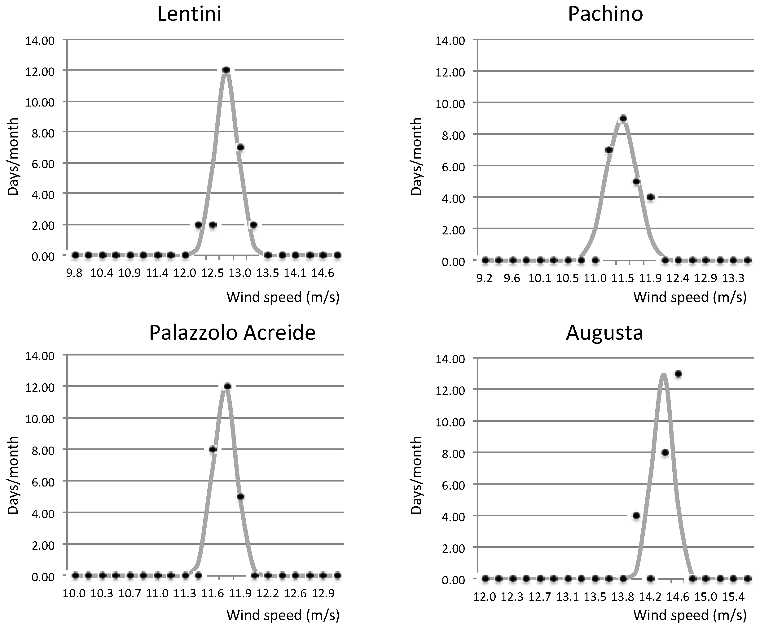
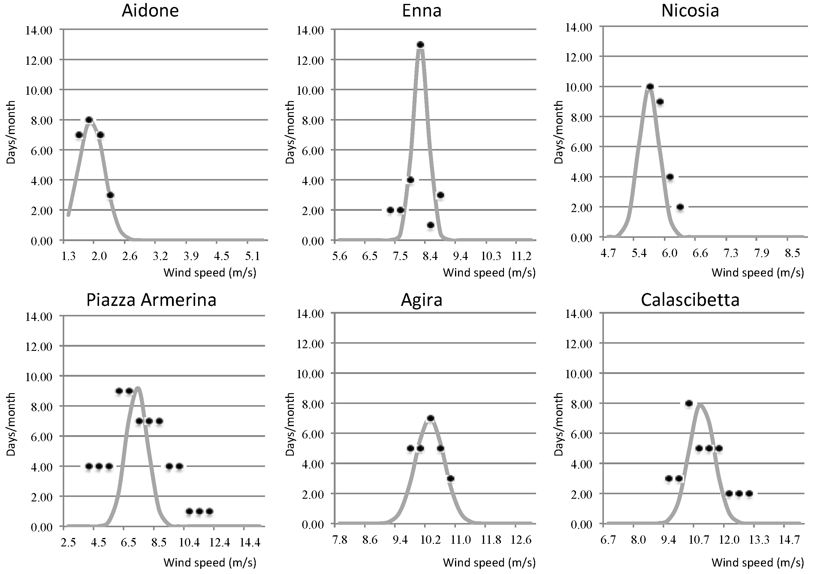
Starting from the anemometric measurements, the windiness was calculated from the wind probability density in each of the areas related to the anemometric stations (
Figure 2 and
Figure 3), and the number of hours of wind was calculated for the various speeds in each of the sites identified for plants in the two Provinces. The relative speeds measured 10 m above the ground (V
2) have been extrapolated to the hub height (80 m, assuming the maximum turbine efficiency): V
80 = V
2 × (80/2)
w, where: V
2 is the speed at the measured height (10 m above ground); and, w is a coefficient that generally depends on the roughness of the terrain [
23].
The productibility of the plants located in the identified areas, measured in MW, is calculated using Betz’s law [
24,
25], which states that the energy extracted from the wind is proportional to the mass flow that passes through the rotor and the difference in kinetic energy between the inlet section and the outlet section:
where
is the power,
is the density of air,
is the rotor area,
is the initial speed of the air, and
is the interference factor, which is generally equal to 1/3. From this, it was possible to calculate the amount of energy that could be produced in a year, and the expected revenue for each turbine, based on the average energy market price.
The costs were calculated considering the sum of the investment and operating cost items.
3.2.2. Landscape Assessment
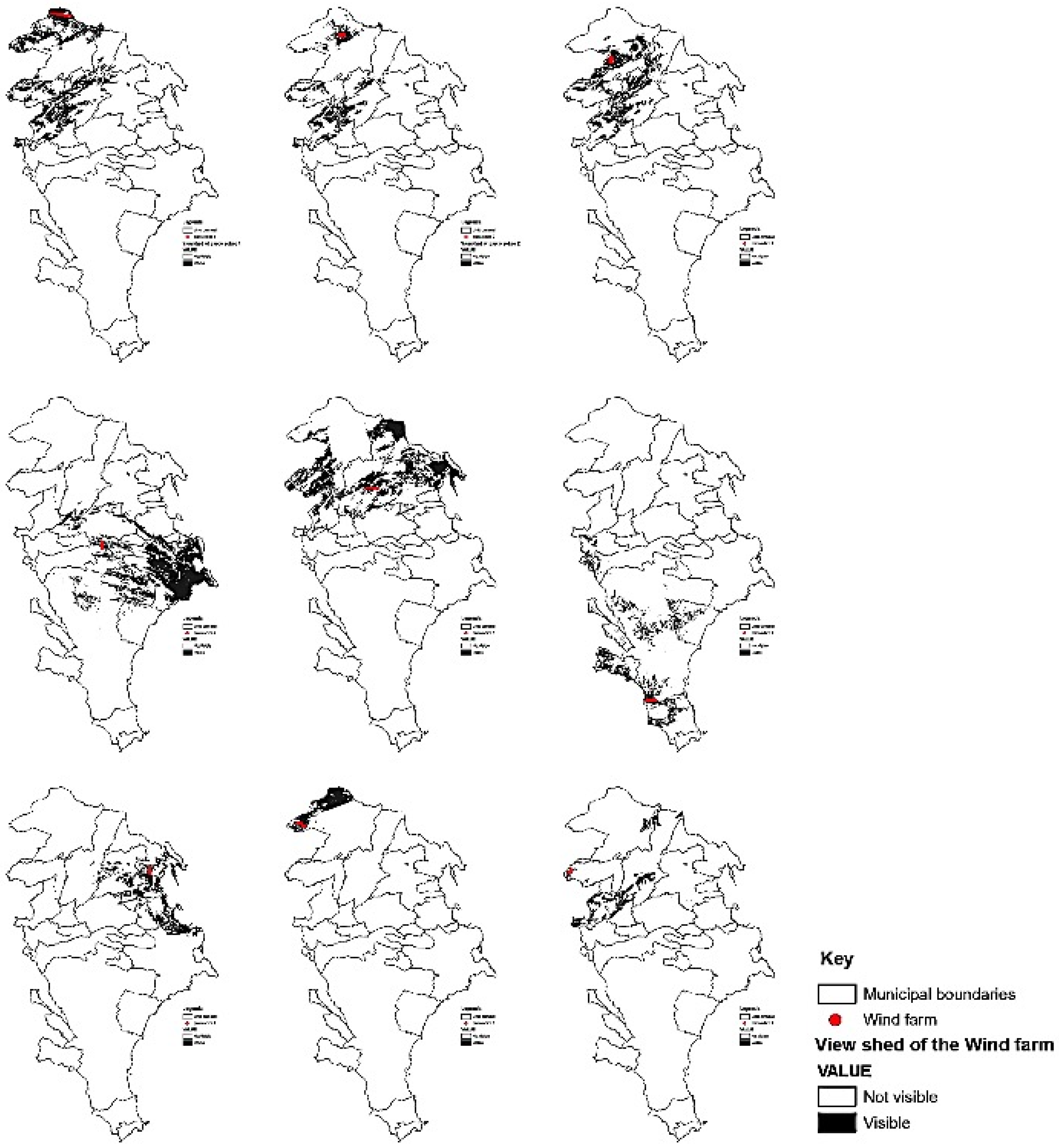
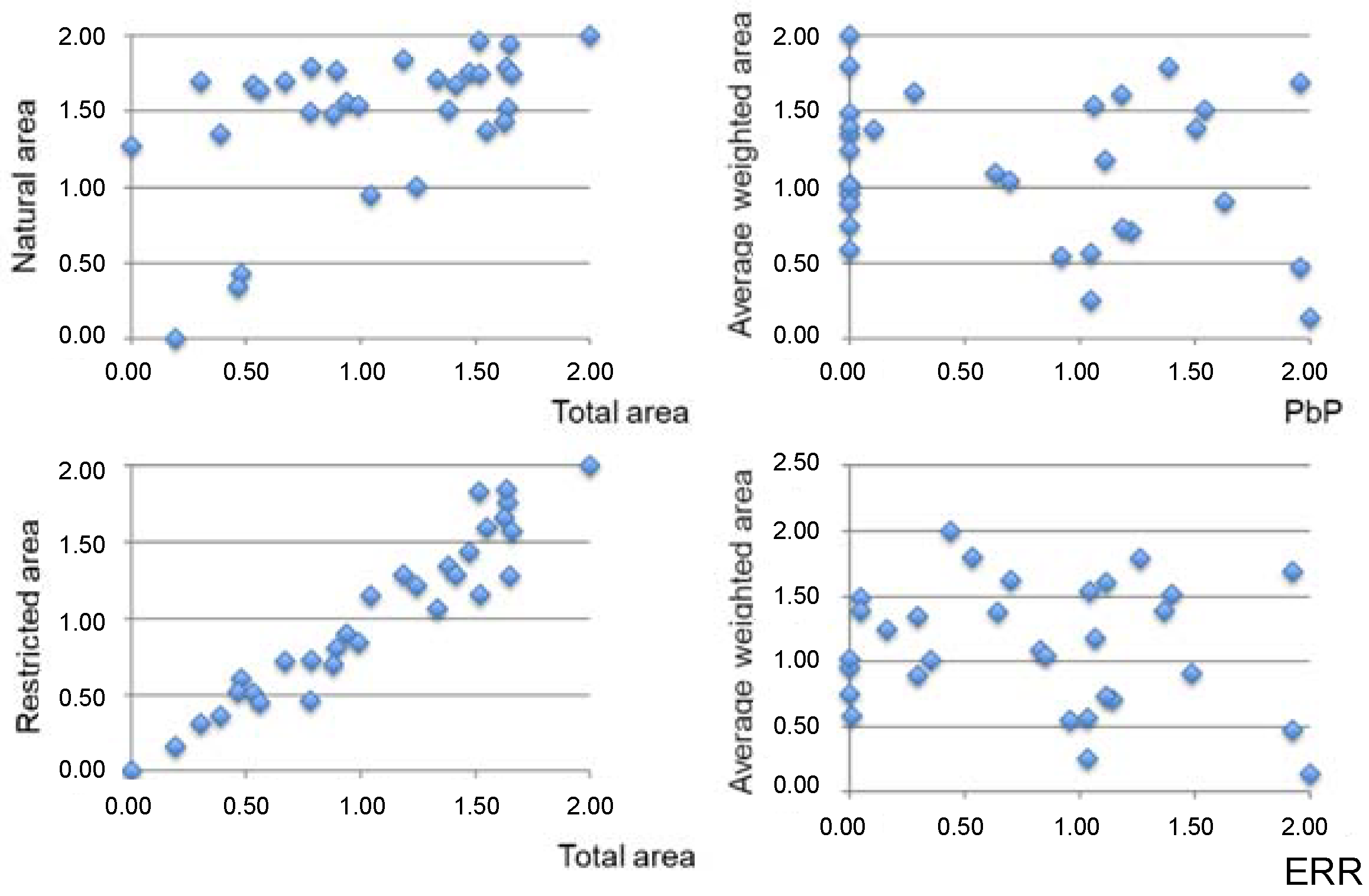
The search for an objective basis for assessing assets with a high information density—which means involving semantics (relationship between signifiers and signified) and syntax (relationship between signs through their internal semantics)—combined with an analysis of a vast area, means greatly simplifying which signifiers to consider in the overall intervisible surface, and weighting them according to their distances and the quality of the intervisible areas from a landscape value point of view.
For this purpose two intervisible area measuring modes and three types of area have been taken into account:
the intervisible area, that is measured:
in absolute terms, to assess the potential impact and the incidental overlapping between areas at different intervisibility;
in relative terms, reducing the entity of the visible area with a coefficient which takes into account the distance and the actually visible size of the turbines;
the considered intervisible area, that is articulated in:
total intervisible area;
intervisible area comprised in the protected areas; and,
intervisible area comprised in natural areas, that means characterized by non productive and non transformative land uses.
Also the intervisibility measurement has been weighted with an index related to the distance and visibility conditions, meaning the portion of the turbine that is visible from each cell (40 × 40 m) of the intervisible surface.
3.2.3. Combination of the Two Valuations
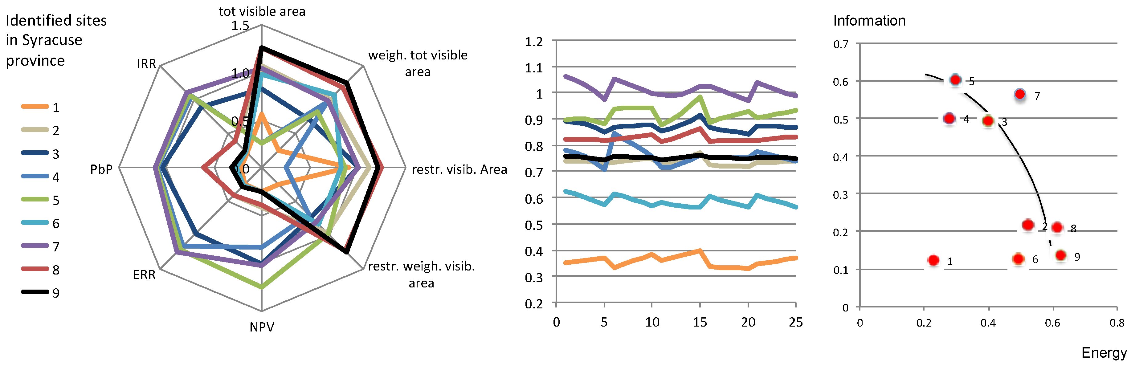
To make the measures of economic convenience comparable to those of the landscape quality, the results of the two analyses, as obtained in the various units of measurement, were normalized on the basis of a standard scale, associating the score with the minimum/maximum value of each performance to the minimum/maximum value of the standard scale, and calculating the intermediate values based on a linear proportionality between minimum and maximum.
Then, each of the obtained score is multiplied by a weighting factor that takes into account the relative importance of each of the mentioned criteria compared to the others.
Now, it is possible:
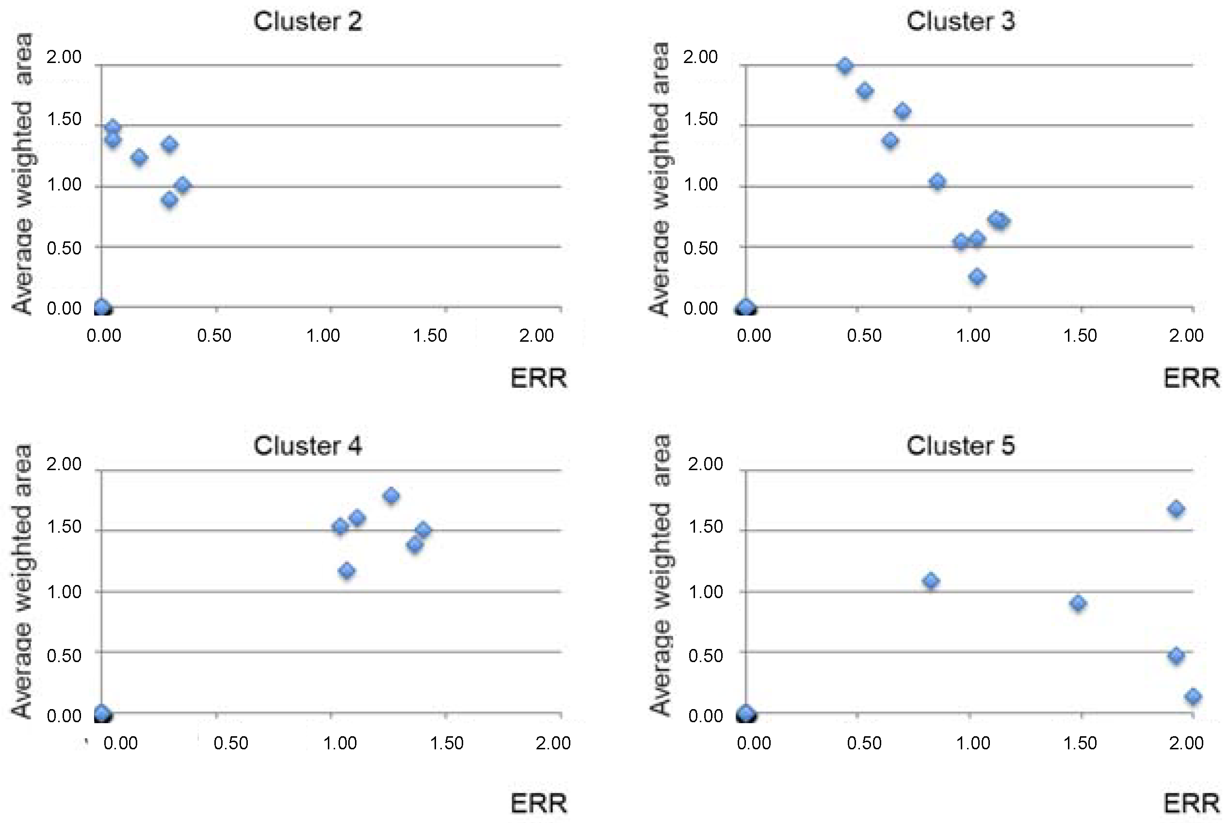
to aggregate the weighted scores in one general score allowing us to get a ranking of all the plant areas from the points of view of all the criteria; and,
to aggregate the weighted scores in two partial scores allowing us to characterize each plant area from the point of view of “energy” (economic criteria) and “information” (landscape criteria); this double characterization can be used to represent the “Pareto frontier”, that is the trade-off between energy and information.
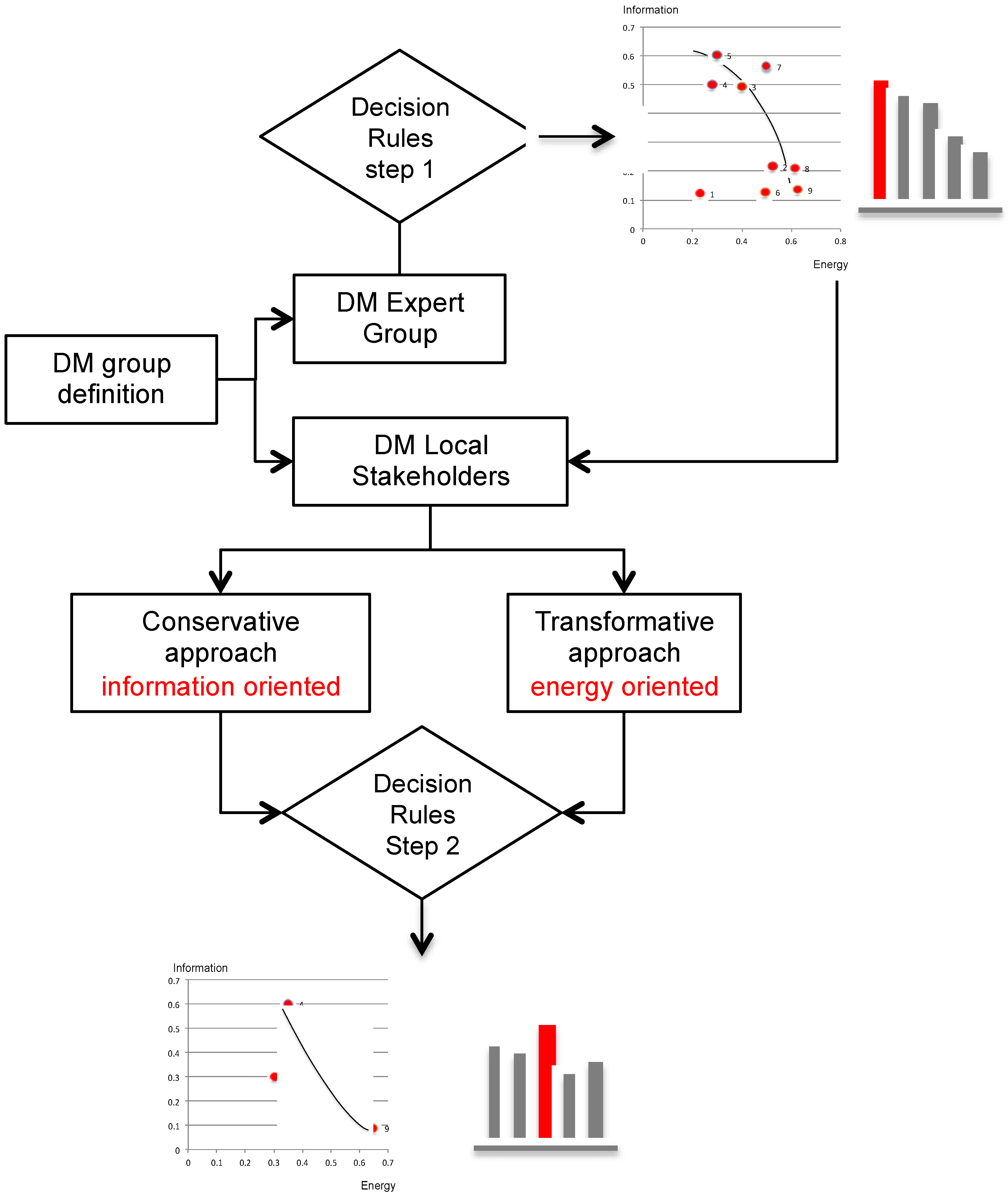
3.3. Syntactic Model. Decision Profiles and Prescriptive Tools
The syntactic model, which was aimed at providing the rules for the optimal layout choice of the wind farm policies at the provincial scale, consists of a decision-making process involving several decision-makers including a group of experts that supports the choices of local stakeholders. The latter are guided according to an iterative relational approach, aimed at identifying diversified preferences structures, capable of eliciting a shared system of preferences aimed at mediating between the reasons of transformation and those of conservation (
Figure 4).
The decision processes help DMs to converge on a choice of actions to implement energy and territorial policies when environmental urgency and the landscape values are in structural conflict.
The process of identifying the preferred structures of the territorial players may be conducted by implementing a suitable decision-making model supported by a specific algorithm.
Among the algorithms developed to aid decisions that lend themselves to identifying decision preference structures, we selected the Interactive Multi-objective Optimization-Dominance-Based Rough Set Approach (IMO-DRSA) [
26,
27].
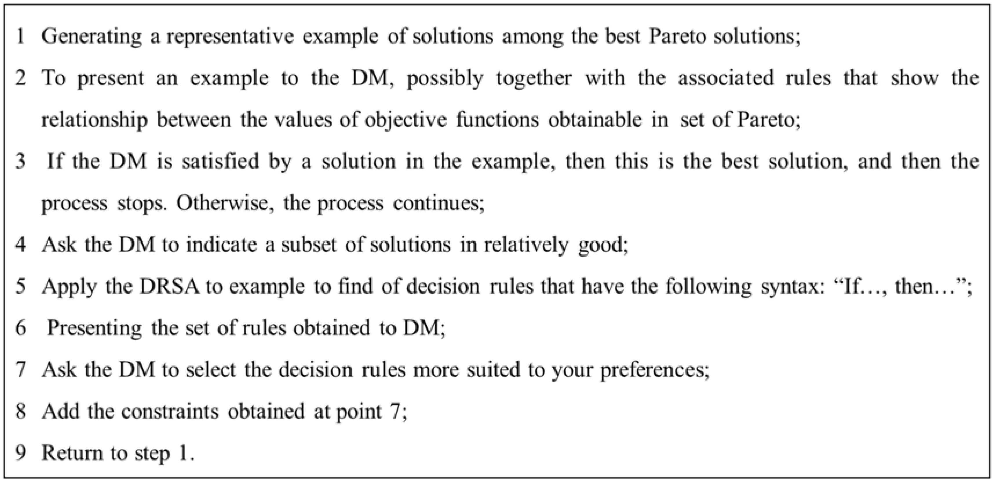
IMO-DRSA is an algorithm that develops through an interactive process, and it can be characterised by several steps, of which two can be considered the main phases (
Figure 5). In the first phase, a sample of solutions is deduced from a Pareto optimal set (or from an approximation thereof) generated in a pre-analysis phase on the basis of the preference structure of an expert group.
In the second, the Decision Maker (DM) is asked to choose acceptable solutions from the example generated. It is possible to extract an initial preference structure from this information, which will be expressed using the typical syntax of the DRSA algorithm family, i.e., in terms of decision rules of the type “if…, then …” [
28,
29,
30]. The rule set generated in this way defines some new constraints that express the preferences of the DMs, which can be added to the original constraints of the problem in order to identify the solutions that are of no interest in the Pareto optimal set generated initially. At this point, having refined the information level, it is possible to generate a new sample of solutions to submit to the DM, who in turn, is asked to express an opinion on the new analysis results. The interaction continues until the decision rule sample generated represents the preference structure of the DM, who has been able to provide feedback during the iteration process.
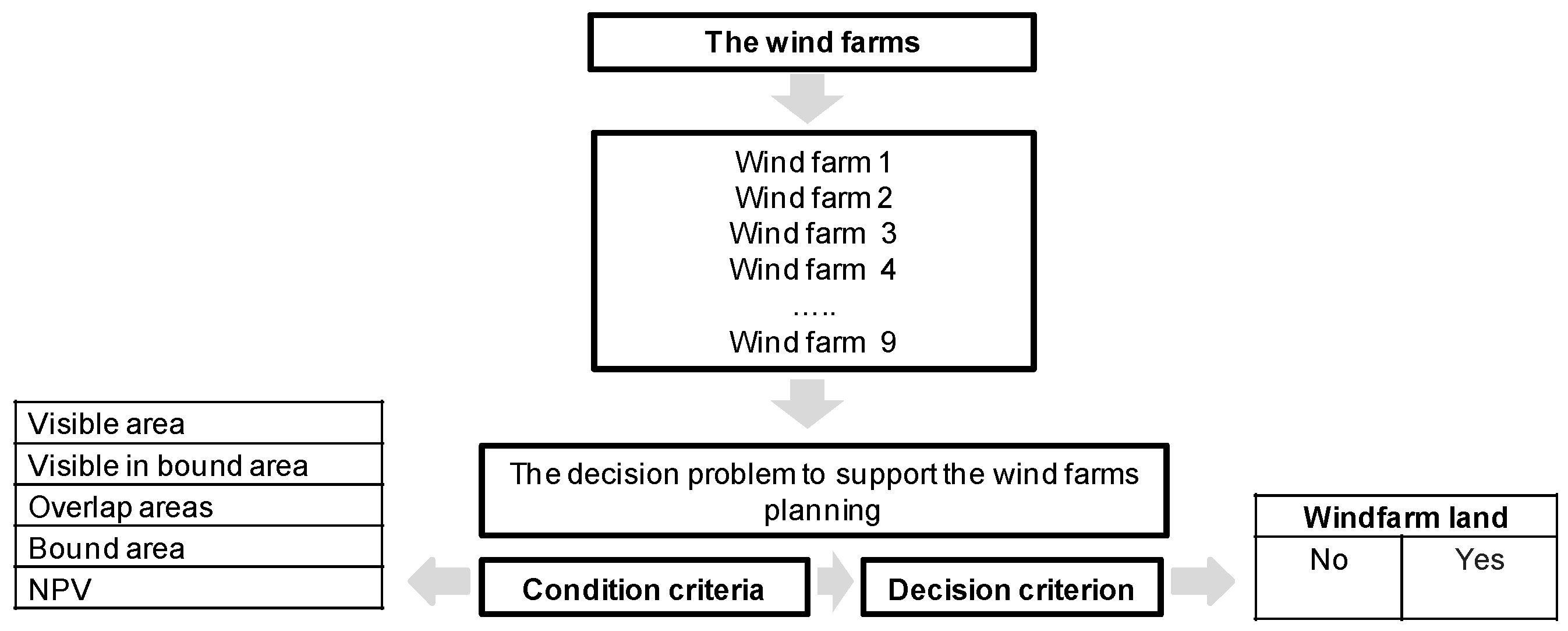
Therefore, the decision model and IMO-DRSA algorithm are able to identify the preference structure of the DM, starting from a successive process of exploration of the Pareto optimal set. The methodology offers a simple language for both inputs and outputs, which is perceived as being natural, being that of decision-making rules (
Figure 6).
Specifically, in the case being studied, the proposed methodology can identity the wind farm that the DM perceives as being the best out of those analysed, in the sense that is explained above. The preference structure identified is defined on the basis of a relationship system that represents the way in which the DM decides, and is therefore characterised by the correlation between a decision and the factors (criteria) that led to it.
In the previous case, the decision model (
Figure 6) is characterised by: a) five condition criteria—total intervisible area, plant visibility in the restricted area, overlapping intervisible area, restricted intervisible area, NPV—and two decision criteria—“no”, meaning the plant must not be implemented, “yes”, meaning the plant may be implemented.
5. Conclusions
The incessant technological progress and the progressive deterioration of natural structures, together with the exponential growth of human needs, are giving rise to a rapid environmental drift to which the economic, social, and political ones inevitably associate. There is no doubt that economic and financial crises and large migratory movements are linked to the environmental question; the convergence of these two circumstances pushes communities to adopt closed attitudes towards the great geopolitical institutions and suspect of supranational aggregations, with a great risk for democracy and the progress of ideas and consciences.
The mission of the Science of evaluations, an operational discipline that is closely linked to the issues of distributive equity of the transformations of local environmental and territorial contexts, is to integrate a multiplicity of evaluation tools within a vision inspired by the combination of “ethics of landscape “and “ aesthetics of economy”.
These two aspects are strongly intertwined with each other due to some circumstances not easy to cope with:
- -
the first, more general, concerns the need to free ourselves from the fossil supply chain, given the extensive and uncontrollable ramification in space and time of its catastrophic effects, not only environmental, but also and above all socio-economic; and,
- -
the second, more directly connected with the shape of the territory, is given by the consumption of soil that every form of “self-sufficient solidarity”—that is the self-production of the energy that is consumed—can provoke, and the consequent impacts.
The exploitation of the wind source is one of the most peculiar cases of this issue, precisely because of the high economic efficiency of the higher wind turbines, and especially the difficulty in ascertaining the visual impact as a negative value, given that the rules of “visual pollution” are not unique, like those of water, atmospheric, acoustic, olfactory pollution, etc.; then, the geography of value is the framework of the fair form of energy.
The case presented in this study is an opportunity to explore the different energy-economic potential of two Sicilian territorial contexts—in many ways opposites—in the light of their formal resilience, with the aim of providing local administrations (regional and provincial) contents, objectives, and tools of the process of selection, evaluation, and planning of energy policies in sensitive landscapes.
The contents are the evaluation terms with which investments in wind farms can be represented and compared in the “space of values”: the two general terms, according to the new approach to value and evaluations proposed by Francesco Rizzo are energy and information, the latter understood as a form of the territory, therefore with reference to the layout of the landscape. The main indicators of these value terms are: for energy the economic measures that make the investments profitable, then the results of the Discounted Cash Flow Analysis; for the information, the visibility of the plants was considered taking into account: the merit of the areas affected by intervisibility; the distance of these areas from the wind farms; the possible overlapping of the intervisible areas. To do this, the spatial analysis functions in the GIS environment were used.
The objectives are the shared decision rules that are based on robust assessments. To this end, once the areas suitable for wind farms have been identified, and the economic value of the related investments and the visual impact have been calculated, a decision model based on the discussion rationality, i.e., the construction of decision rules, has been elicited:
- -
by two groups of decision makers, experts and administrators/stakeholders; and,
- -
by considering two different approaches, one more conservative, the other more transformative.
The tools that we used in this proposal are: the GIS spatial analysis for the selection of the suitable areas according to the restricted areas, the road network and the built-up areas; the Discounted Cash Flow Analysis taking into account the revenues depending on the different producibility of each plant areas due to the foreseen windiness; the IMO-DRSA relational pattern, a Decision Making path aimed at the construction of the rules that allow for the administrators to implement policies based on shared decisions.
The province of Enna, covering the central area of Sicily, due to its position and to the roughness of its mountainous territory that dampens the currents, is less suitable for the implementation of wind farms. As a consequence, of the 31 suitable areas, only seven were actually profitable, those that were placed on the highest mountain ranges, and therefore with greater visual impact, as shown by the GIS calculations and displayed by the intervisibilty map.
The province of Siracusa, due to its position and the large water front, in addition to its orography, takes advantage of better anemomentric conditions that make investments in wind farms much more profitable. On the other hand, a greater density of cultural and landscape values reduces the suitable areas and the possibilities of exploitation of the wind resource.
It follows that the territory of the province of Siracusa is more able to concentrate the potential of wind energy and reveals the context of greater economic-energy efficiency.
Some quantitative results may be useful to outline a geography of values for each of the two territories identified by the proposed axiological filter: the calculated total energy potential, assuming 66 for Siracusa and 140 for Enna 3 MW generators, which corresponds to a productibility, respectively, of 61 and 16 MW, with a notable efficiency gap with regard to the economic result, given that the unit cost is around 1700 per kW. The landscape cost is also very different, being 976 (for Siracusa) and 1682 (for Enna) km
2. Consequently, extending this tool to the whole regional territory would make it possible to define the intervention priorities consistently, and to bring analyses together where effectively necessary, making the whole information and organisation system more efficient, according to a single multi-level method [
32,
33]. The proposed tool supports a “value geography policy”, which connects the horizontal dimension of extensive knowledge with the vertical dimension of detailed analytical assessment to consolidate a summary vision that is based on value judgments.
These results have suggested some in-depth analysis, useful for the economic-territorial planning, aimed at defining the trade-off relations between performances related to energy and information, and subsequently, through the application of a structured decision-making consultation process, a set of decision rules that mediate between a conservative, information-oriented, and a transformative, energy-oriented approach.
The different energy-information profiles of the two provinces constitute the topical example of non-dominant alternatives whose choice first requires a robust model of analysis and evaluation and then a decision-making process whose level of participation is guaranteed by the elicitation of decision-making rules inspired by forms of discussion rationality.


