
Globalland30 Mapping Capacity of Land Surface Water in Thessaly, Greece

 ,
, 
 and
and
Abstract
:
1. Introduction
1.1. Background
1.2. Most Recent Developments
2. Study Area and Materials
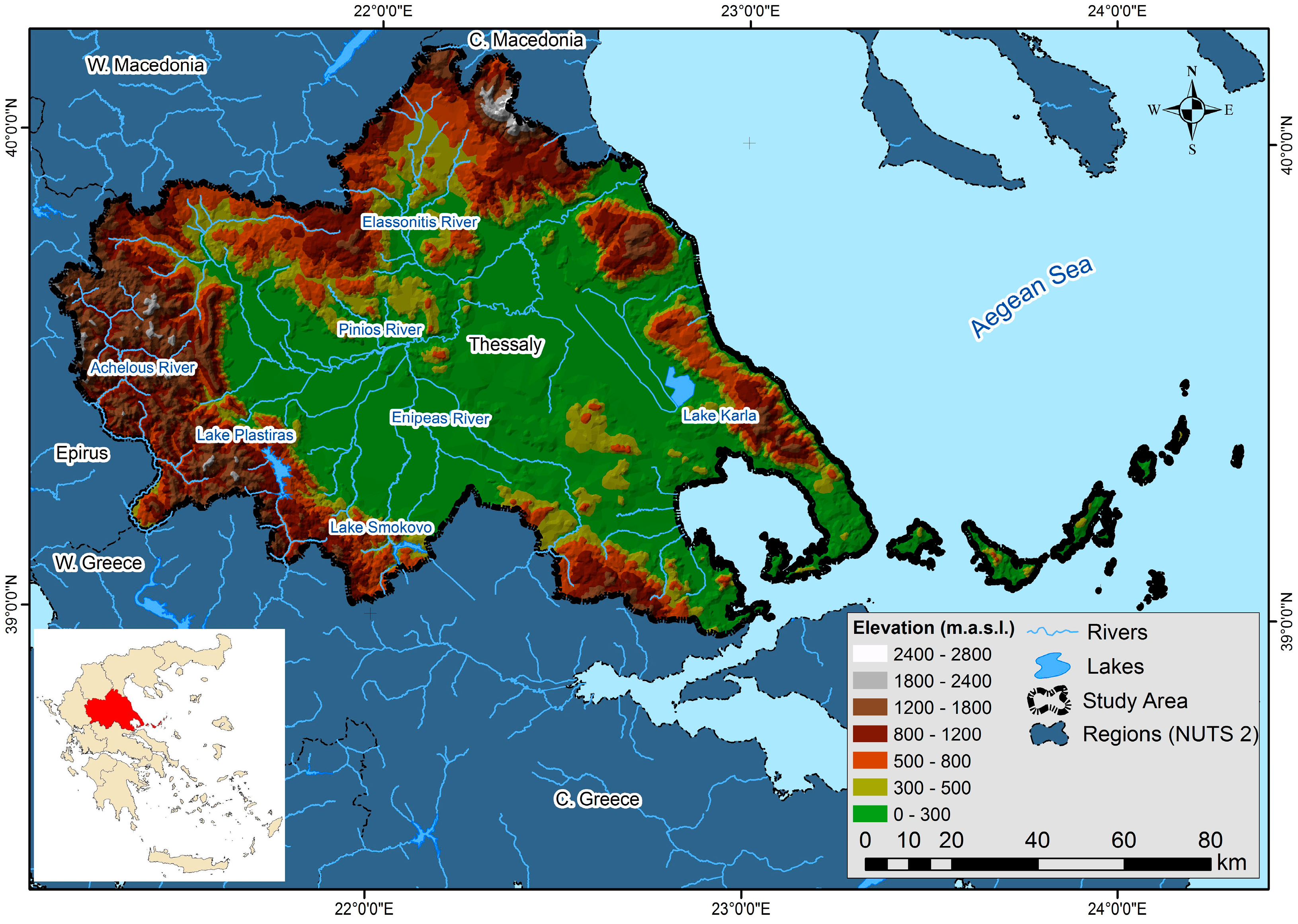
2.1. Study Area

2.2. Materials

| Data Source | Type | Minimum Mapping Unit |
|---|---|---|
| RapidEye [50] | Raster | 6.5 × 6.5 m2 |
3. Experimental Section
3.1. Class Definitions
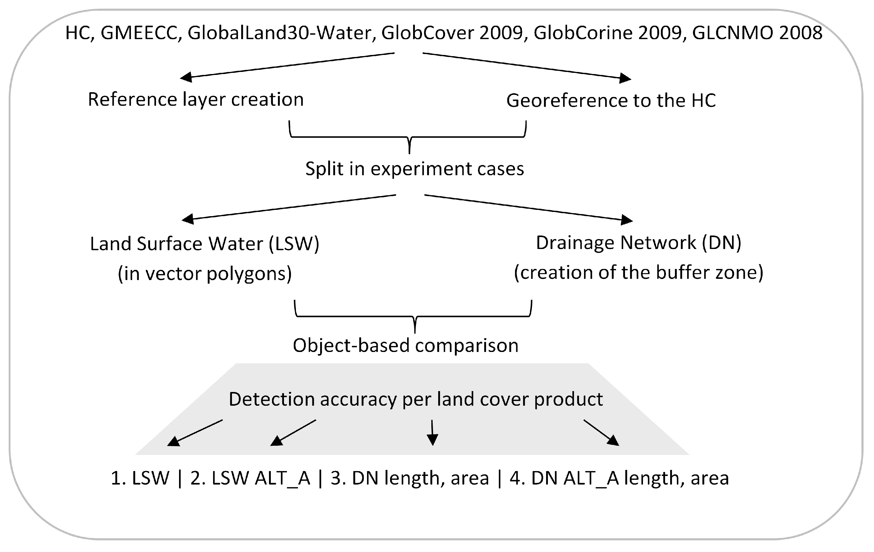
3.2. Reference Data Set Creation
- (a)
- The visual interpretation and water areas’ polygons digitization on screen was supported by an initial recognition of possible water covered areas. In favor of their availability, autumn RapidEye images of 2011 have been classified to create an initial polygon layer to capture the land surface water areas. The summer dry period prior to the acquisition enhanced the detectability of water areas’ boundaries that are maintained throughout the year. Pixel based supervised classification was performed in order to identify water and non-water classes. It aimed solely for rapid pre-identification of possible water covered areas. Confirmation or rejection of these polygons was later undertaken based on the Hellenic Cadastre (HC) base map.
- (b)
- With the additional calculation of the normalized difference vegetation index (NDVI) [58] and the NDWI [59] layers from the RapidEye images, further possible areas indicating increased wetness were derived. Following this procedure, a preliminary list of 816 polygons describing the detectable wetness areas was generated in an effort to capture all water covered areas, to minimize, if not eliminate, the omission error for the extent of the study area.
- (c)
- In this step photointerpretation took place. In order to counterbalance definition discrepancies, LSWs were considered as the areas, where water covering the underlying ground (water table) could be visible while looking from above (air or satellite operating height). Extensive evaluation of each point was performed, supported by the Hellenic Cadastre (HC) base map. Via the use of the HC, the presence of LSW around the 816 centroids of the previously extracted polygons was searched. Through the HC map, 682 water bodies were finally delineated through visual interpretation and digitized as polygons on screen.
- (d)
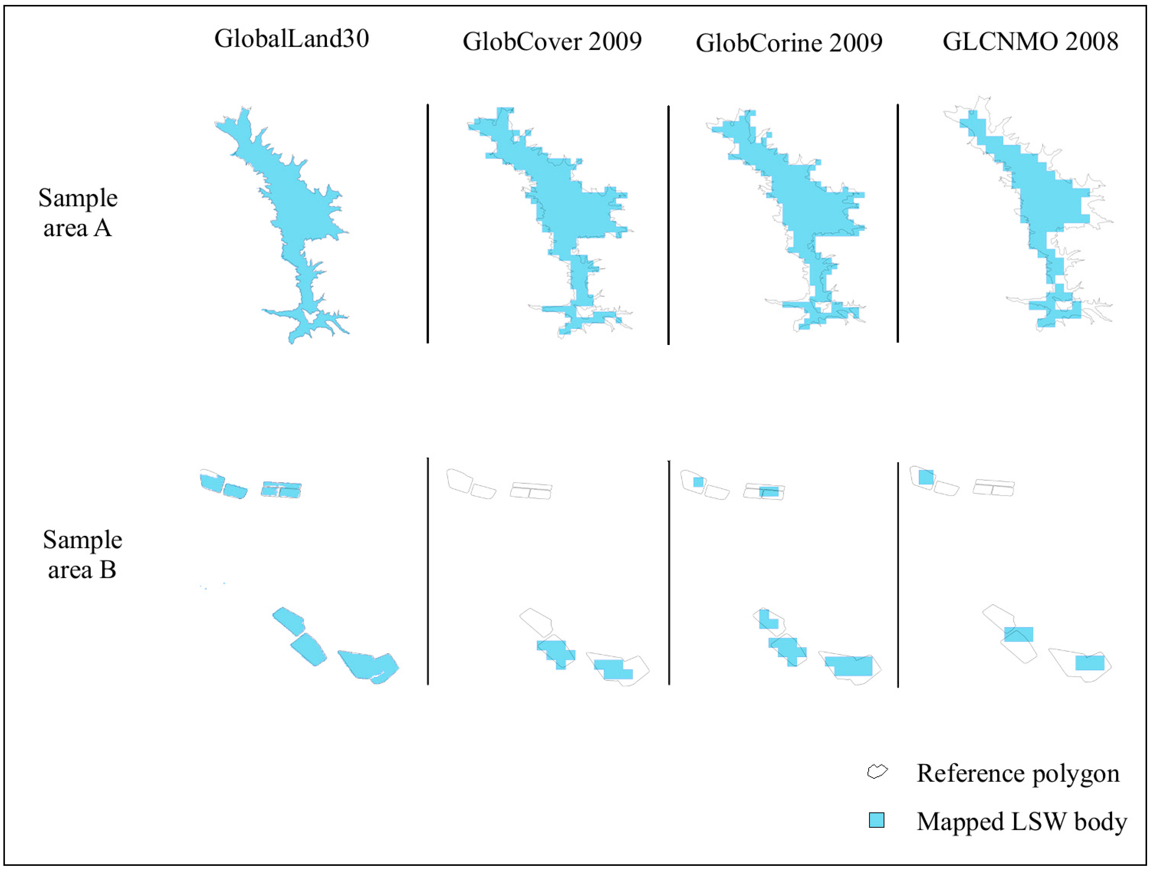
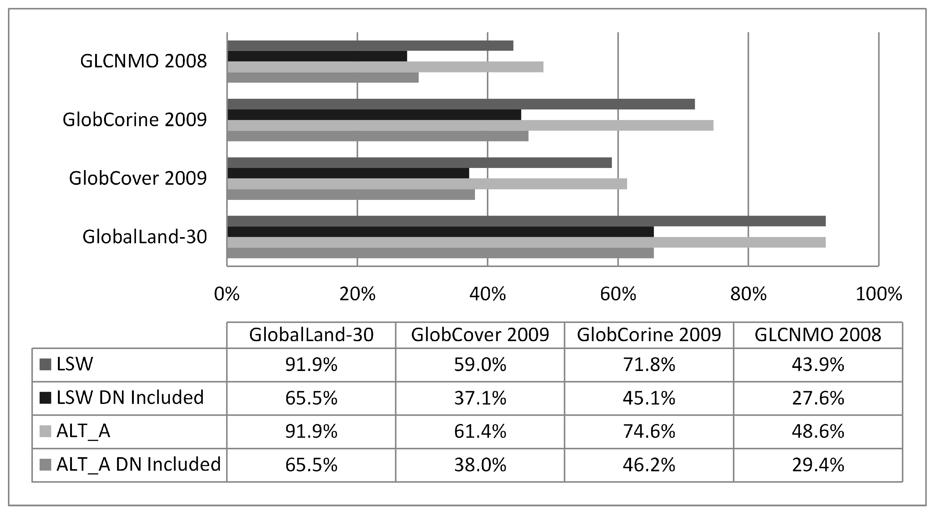
- These polygons were overlapped with the time series of very high resolution satellite images derived from Google Earth (GE) software [60]. Parts of the study area were covered by coarse resolution GE images, when the respective acquisition series around the global layers’ production years and seasons were sought (summer 2009, 2009, 2009, 2008) for the 4 layers (GlobalLand30, GlobCover 2009, GlobCorine 2009, and GLCNMO 2008). These partial areas were masked out during the evaluation process and the respective polygons were removed from the reference layer accordingly.
- (e)
- For the remaining polygons very high resolution (<4 m) GE imagery partial snapshots of the enclosed surface and their imminent surroundings were acquired and co-registered via control points’ coordinates to the HC equivalent sub-areas with RMSExy ≤ 4 m. Selected GE very high resolution imagery parts of the same, previous, and following year are incorporated into the evaluation process to cope with the seasonality fluctuation of the land surface water bodies. Then the initially delineated reference polygons were re-digitized and reshaped according to the open water surface extent of the GE partial imageries using photointerpretation. Knowledge of the local conditions in relation to artificial boundaries of several land surface water areas was incorporated into the procedure. In cases of uncertainty or discrepancy the closest imagery date and/or smaller polygon area was favored to cope for the generally prevailing evapotranspiration conditions of the area.
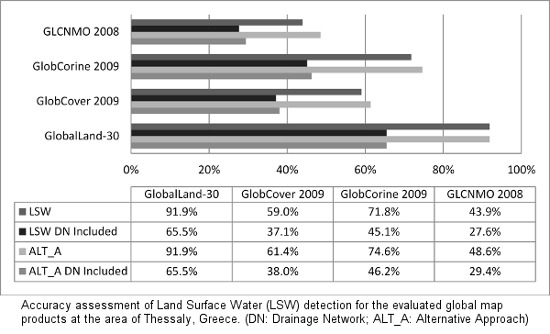
3.3. GlobalLand30-Water Accuracy Assessment Approach


- Their length was calculated by comparing the length of the rivers extracted by the GlobalLand30-Water with the total length of the digitized rivers.
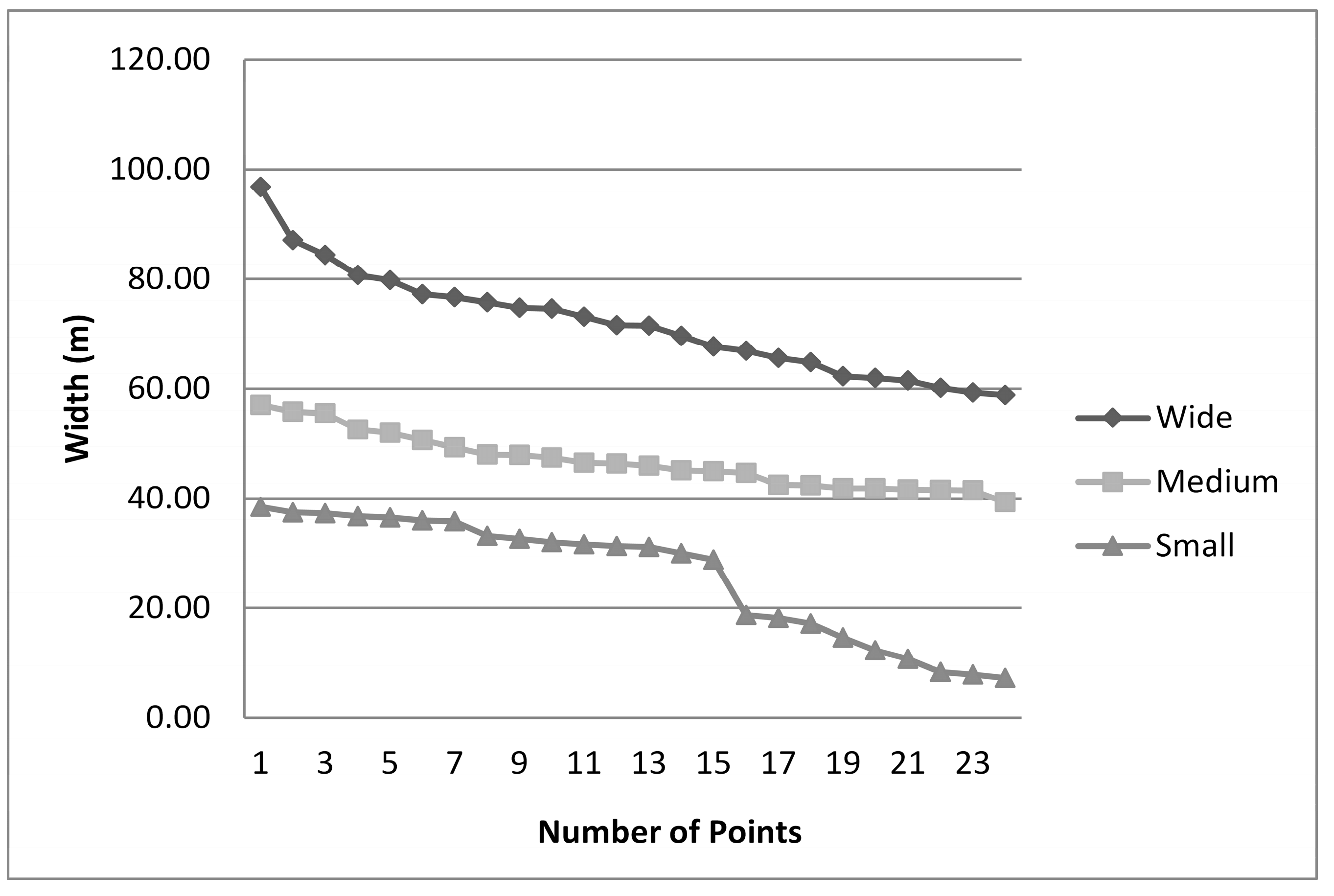
- In regard to the extent of the open water area present in the rivers, a different method was followed to avoid the time-consuming digitization of this large area. At a representative number of points, randomly distributed on the DN, transects across the rivers were digitized, enabling the measurement of each transect’s width. The widths were ranked in a list from higher to lower, then categorized into 3 groups and each group’s average width was calculated. The rivers were then divided into linear subparts according to their width as estimated from the GE imagery (each subpart had a low variance of individually measured widths), buffered automatically with a radius of the respective average width and re-arranged (digitized again) in 3 different linear shapefiles, namely “Wide”, “Medium”, and “Narrow” (Figure 4). It is worth mentioning that in the “Narrow” class there were points that could belong to a 4th group with significantly smaller width. This group was intentionally left out, because of the average class width of 26 m that was already lower than GlobalLand30-Water spatial resolution. These buffered regions were thereafter overlaid with the GlobalLand30-Water equivalent areas.

3.4. GlobCover 2009, GlobCorine 2009 and GLCNMO 2008 Accuracy Assessment Approach
4. Results
5. Discussion
6. Conclusions
Acknowledgments
Author Contributions
Conflicts of Interest
References
- APN. GEOSS/Asian Water Cycle Initiative/Water Cycle Integrator (GEOSS/AWCI/WCI). Available online: http://www.apn-gcr.org/resources/items/show/1755 (accessed on 25 June 2014).
- Fletcher, K. Sentinel-1: ESAs Radar Observatory Mission for GMES Operational Services. Tech. Rep. SP-1322/1, ESA 2012. Available online: http://esamultimedia.esa.int/multimedia/publications/SP-1322_1/ (accessed on 14 June 2014).
- UNECE. Convention on the Protection and Use of Transboundary Water courses and International Lakes. Available online: http://www.unece.org/fileadmin/DAM/env/water/pdf/watercon.pdf (accessed on 25 June 2014).
- IPCC. Climate Change 2013: The Physical Science Basis. Contribution of Working Group I to the Fifth Assessment Report of the Intergovernmental Panel on Climate Change; Cambridge University Press: Cambridge, UK; New York, NY, USA, 2013. [Google Scholar]
- Langanke, T.; Büttner, G.; Dufourmont, H.; Steenmans, C. High resolution land cover mapping on a continental scale for 39 European countries. Context status applications future developments. In Proceedings of the 35th International Symposium Remote Sensing of the Environment (ISRSE), Beijing, China, 22–26 April 2013.
- Arnold, S.; Kosztra, B.; Banko, G.; Smith, G.; Hazeu, G.; Bock, M.; Sanz, N.V. The EAGLE concept—A vision of a future European land monitoring framework. In Proceedings of the 33rd EARSeL Symposium “Towards Horizon 2020: Earth Observation and Social Perspectives”, Matera, Italy, 3–6 June 2013; pp. 551–569.
- Defries, R.S.; Townshend, J.R.G. NDVI derived land cover classifications at a global scale. Int. J. Remote Sens. 1994, 15, 3567–3586. [Google Scholar] [CrossRef]
- Defries, R.S.; Hansen, M.; Townshend, J.R.G.; Sohlberg, R. Global land cover classifications at 8 km spatial resolution: The use of training data derived from Landsat imagery in decision tree classifiers. Int. J. Remote Sens. 1998, 19, 3141–3168. [Google Scholar] [CrossRef]
- Hansen, M.C.; Defries, R.S.; Townshend, J.R.G.; Sohlberg, R. Global land cover classification at 1 km spatial resolution using a classification tree approach. Int. J. Remote Sens. 2000, 21, 1331–1364. [Google Scholar] [CrossRef]
- Loveland, T.R.; Belward, A.S. The IGBP-DIS Global 1 km land cover data set, DISCover: First results. Int. J. Remote Sens. 1997, 18, 3289–3295. [Google Scholar] [CrossRef]
- Loveland, T.R.; Reed, B.C.; Brown, J.F.; Ohlen, D.O.; Zhu, Z.; Yang, L.; Merchant, J.W. Development of a global land cover characteristics database and IGBP DISCover from 1 km AVHRR Data. Int. J. Remote Sens. 2000, 21, 1303–1330. [Google Scholar] [CrossRef]
- Mücher, C.A.; Steinnocher, K.T.; Kressler, F.P.; Heunks, C. Land cover characterization and change detection for environmental monitoring of pan-Europe. Int. J. Remote Sens. 2000, 21, 1159–1181. [Google Scholar] [CrossRef]
- Mücher, C.A.; Steinnocher, K.T.; Champeaux, J.L.; Griguolo, S.; Wester, K.; Heunks, C.; Katwijk, V.V. Establishment of a 1-km pan-European land cover database for environmental monitoring. Int. Arc. Photogramm. Remote Sens. 2000, 33, 702–709. [Google Scholar]
- Friedl, M.; McIver, D.; Hodges, J.; Zhang, X.; Muchoney, D.; Strahler, A.; Woodcock, C.; Gopal, S.; Schneider, A.; Cooper, A.; et al. Global land cover mapping from MODIS: Algorithms and early results. Remote Sens. Environ. 2002, 83, 287–302. [Google Scholar] [CrossRef]
- Friedl, M.A.; Sulla-Menashe, D.; Tan, B.; Schneider, A.; Ramankutty, N.; Sibley, A.; Huang, X. MODIS Collection 5 global land cover: Algorithm refinements and characterization of new datasets. Remote Sens. Environ. 2010, 114, 168–182. [Google Scholar] [CrossRef]
- Tateishi, R.; Uriyangqai, B.; al-Bilbisi, H.; Ghar, M.A.; Tsend-Ayush, J.; Kobayashi, T.; Kasimu, A.; Hoan, N.T.; Shalaby, A.; Alsaaideh, B.; et al. Production of global land cover data GLCNMO. Int. J. Dig. Earth 2011, 4, 22–49. [Google Scholar] [CrossRef]
- ISCGM. Global Map Specifications Version 2.2. 2012. Available online: http://www.iscgm.org/cgibin/fswiki/wiki.cgi?action=ATTACH&page=Documentation&file=Global+Mapping+Specifications+Version+2.2.pdf (accessed on 25 June 2014).
- Bartholomé, E.; Belward, A.S. GLC2000: A new approach to global land cover mapping from earth observation data. Int. J. Remote Sens. 2005, 26, 1959–1977. [Google Scholar] [CrossRef]
- Arino, O.; Gross, D.; Ranera, F.; Leroy, M.; Bicheron, P.; Brockman, C.; Defourny, P.; Vancutsem, C.; Achard, F.; Durieux, L.; et al. GlobCover: ESA service for global land cover from MERIS. In Proceedings of the 2007 IEEE International Geoscience and Remote Sensing Symposium, Barcelona, Spain, 23–28 July 2007; pp. 2412–2415.
- Defourny, P.; Bicheron, P.; Brockmann, C.; Bontemps, S.; van Bogaert, E.; Vancutsem, C.; Huc, M.; Leroy, M.; Ranera, F.; Achard, F.; et al. The first 300 m global land cover map for 2005 using ENVISAT MERIS time series: A product of the GlobCover system. In Proceedings of the 33rd International Symposium of Remote Sensing of the Environment, Stresa, Italy, 4–8 May 2009; pp. 1–4.
- Defourny, P.; Schouten, L.; Bartalev, S.; Bontemps, S.; Caccetta, P.; de Witt, A.; di Bella, C.; Gerard, B.; Giri, C.; Gond, V.; et al. Accuracy assessment of a 300 m global land cover map: The GlobCover experience. In Proceedings of the 33rd International Symposium of Remote Sensing of the Environment, Stresa, Italy, 4–8 May 2009.
- Bontemps, S.B.; Defourny, P.; van Bogaert, E.; Arino, O.; Kalogirou, V.; Perez, J.R. GLOBCOVER 2009 Products Description and Validation Report Tech. Rep. 2.2. Université Catholique de Louvain—European Space Agency, 2011. Available online: http://due.esrin.esa.int/globcover/LandCover2009/GLOBCOVER2009_Validation_Report_2.2.pdf (accessed on 25 June 2014).
- Bontemps, S.B.; Defourny, P.; van Bogaert, E.; Weber, J.L.; Arino, O. GlobCorine—A joint EEA-ESA project for operational land cover and land use mapping at pan-European scale. In Proceedings of the ESA Living Planet Symposium, Bergen, Norway, 27 June–2 July 2010.
- Defourny, P.; Bontemps, S.B.; van Bogaert, E.; Weber, J.L.; Steenmans, C.; Brodsky, L.; Arino, O.; Kalogirou, V. GLOBCORINE 2009: Description and Validation Report Technical Report 2 rev.1. Université Catholique de Louvain—European Space Agency, 2010. Available online: http://due.esrin.esa.int/files/p114/GLOBCORINE2009_DVR_2.1.pdf (accessed on 25 June 2014).
- Foody, G.M.; Muslim, A.M.; Atkinson, P.M. Super-resolution mapping of the waterline from remotely sensed data. Int. J. Remote Sens. 2005, 26, 5381–5392. [Google Scholar] [CrossRef]
- Livingston, B.; Frazier, P.; Louis, J. Remote sensing of riverine water bodies. In Proceedings of the 10th Australasian Remote Sensing and Photogrammetry Conference, Adelaide, SA, Australia, 21–25 August 2000; pp. 1119–1123.
- Frazier, P.S.; Page, K.J. Water body detection and delineation with Landsat TM data. Photogramm. Eng. Remote Sens. 2000, 66, 1461–1467. [Google Scholar]
- Li, W.; Du, Z.; Ling, F.; Zhou, D.; Wang, H.; Gui, Y.; Sun, B.; Zhang, X. A comparison of land surface water mapping using the normalized difference water index from TM, ETM+ and ALI. Remote Sens. 2013, 5, 5530–5549. [Google Scholar] [CrossRef]
- Shrestha, R.; Liping, D. Land/water detection and delineation with Landsat data using Matlab/ENVI. In Proceedings of the Second International Conference on Agro-Geoinformatics (Agro-Geoinformatics), Fairfax, VA, USA, 12–16 August 2013; pp. 211–214.
- Raitala, J.; Jantunen, H.; Lampinen, J. Application of Landsat satellite data for mapping aquatic areas in North-Eastern Finland. Aquat. Bot. 1985, 21, 285–294. [Google Scholar] [CrossRef]
- Radhakrishnan, N.; Elango, L. Lake environments along the coast of Tamilnadu, India, delineated by IRS-IA satellite data. Lakes Reserv. Res. Manag. 1996, 2, 163–167. [Google Scholar] [CrossRef]
- Sivanpillai, R.; Miller, S.N. Benefits of pan-sharpened Landsat imagery for mapping small waterbodies in the Powder River Basin, Wyoming, USA. Lakes Reserv. Res. Manag. 2008, 13, 69–76. [Google Scholar] [CrossRef]
- Sivanpillai, R.; Miller, S.N. Improvements in mapping water bodies using ASTER data. Ecol. Inform. 2010, 5, 73–78. [Google Scholar] [CrossRef]
- Stone, R. Earth-observation summit endorses global data sharing. Science 2010, 330, 902. [Google Scholar] [CrossRef] [PubMed]
- Kuntz, S.; Schmeer, E.; Jochum, M.; Smith, J. Towards an European land cover monitoring service and high-resolution layers. In Land Use and Land Cover Mapping in Europe: Practices and Trends; Manakos, I., Braun, M., Eds.; Springer: Dordtrecht, The Netherlands, 2014; pp. 43–52. [Google Scholar]
- Chen, J.; Chen, J.; Gong, P.; Liao, A.P.; He, C.Y. High resolution global land cover mapping. Geomat. World 2011, 9, 12–14. [Google Scholar]
- Gong, P.; Wang, J.; Yu, L.; Zhao, Y.; Zhao, Y.; Liang, L.; Niu, Z.; Huang, X.; Fu, H.; Liu, S.; et al. Finer resolution observation and monitoring of global land cover: First mapping results with Landsat TM and ETM+ data. Int. J. Remote Sens. 2013, 34, 2607–2654. [Google Scholar] [CrossRef]
- Chen, J. Higher resolution global land cover mapping. In Proceedings of the International Archives of Photogrammetry Remote Sensing and Spatial Information Science XXXVIII, Kyoto, Japan, 9–12 August 2010; pp. 740–741.
- Cao, X.; Chen, J.; Chen, L.J.; Liao, A.P.; Sun, F.D.; Li, Y.; Li, L.; Lin, Z.H.; Pang, Z.G.; Chen, J.; et al. Preliminary analysis of spatiotemporal pattern of global land surface water. Sci. China Earth Sci. 2014, 57, 1–10. [Google Scholar] [CrossRef]
- Liao, A.; Chen, L.; Chen, J.; He, C.; Cao, X.; Chen, J.; Peng, S.; Sun, F.; Gong, P. High-resolution remote sensing mapping of global land water. Sci. China Earth Sci. 2014, 57, 2305–2316. [Google Scholar] [CrossRef]
- Geo. SB-02-C1: Global Land Cover Datasets and Service. 2013. Available online: http://www.earthobservations.org/ts.php (accessed on 25 June 2014).
- NGCC. Higher resolution global land cover mapping project. National Geomatics Center of China. 2014. Available online: http://www.globallandcover.com (accessed on 25 June 2014).
- ISCGM. Global Map v.2 (Global Version) Land Cover (GLCNMO). 2008. Available online: http://www.iscgm.org/gmd/download/glcnmo2.html (accessed on 25 June 2014).
- Directorate of Regional Planning. In Evaluation, Revision and Specialization of the Regional Framework for Spatial Planning and Sustainable Development of Thessaly Region, Phase A—Stage A2; Hellenic Republic, Ministry of the Environment, Energy and Climate Change, General Secretariat of Regional Planning and Urban Environment: Athens, Greece, 2013. (In Greek)
- Koutsoyiannis, D.; Andreadakis, A.; Mavrodimou, R.; Christofides, A.; Mamassis, N.; Efstratiadis, A.; Koukouvinos, A.; Karavokiros, G.; Kozanis, S.; Mamais, D.; et al. National Programme for the Management and Protection of Water Resources, Support on the Compilation of the National Programme for Water Resources Management and Preservation. Tech. Rep.; Department of Water Resources and Environmental Engineering, National Technical University of Athens: Athens, Greece, 2008. (In Greek) [Google Scholar]
- Tsakiris, S.; Daskalakis, K.; Laganidou, E. Evaluation, Review and Specialization of the Regional Framework for Spatial Planning and Sustainable Development of the Region of Thessaly. 2012. Available online: http://www.pthes.gov.gr/data/anakoin/2013/an222a.pdf (accessed on 25 June 2014). (In Greek) [Google Scholar]
- BlackBridge: RapidEye. Available online: http://www.blackbridge.com/rapideye/index.html (accessed on 10 November 2014).
- OpenLandService. Available online: http://www.globallandcover.com (accessed on 10 November 2014).
- GlobCover: Welcome to the European Space Agency GlobCover Portal. Available online: http://due.esrin.esa.int/globcover/ (accessed on 10 November 2014).
- Pangaea: Data Description. Available online: http://doi.pangaea.de/10.1594/PANGAEA.778363 (accessed on 10 November 2014).
- International Steering Committee for Global Mapping: Download Page. Available online: https://www.iscgm.org/gmd/ (accessed on 10 November 2014).
- National Cadaster and Mapping Agency S.A. Available online: http://gis.ktimanet.gr/wms/ktbasemap/default.aspx (accessed on 10 November 2014). (In Greek)
- Public, Open Data. Available online: http://geodata.gov.gr/geodata/ (accessed on 10 November 2014). (In Greek)
- Alrababah, M.A.; Alhamad, M.N. Land use/cover classification of arid and semiarid Mediterranean landscapes using Landsat ETM. Int. J. Remote Sens. 2006, 27, 2703–2718. [Google Scholar] [CrossRef]
- Manandhar, R.; Odeh, I.O.A.; Ancev, T. Improving the accuracy of land use and land cover classification of Landsat data using post-classification enhancement. Remote Sens. 2009, 1, 330–344. [Google Scholar] [CrossRef]
- Rozenstein, O.; Karnieli, A. Comparison of methods for land-use classification incorporating remote sensing and GIS inputs. Appl. Geogr. 2011, 31, 533–544. [Google Scholar] [CrossRef]
- Bicheron, P.; Defourny, P.; Brockmann, C.; Schouten, L.; Vancutsem, C.; Huc, M.; Bontemps, S.; Leroy, M.; Achard, F.; Herold, M.; et al. GLOBCOVER: Products Description and Validation Report; MEDIAS-France: Toulouse, France, 2008. [Google Scholar]
- Kriegler, F.J.; Malila, W.A.; Nalepka, R.F.; Richardson, W. Pre-processing transformations and their effects on multispectral recognition. In Proceedings of the 6th International Symposium of Remote Sensing of the Environment, Ann Arbor, MI, USA, 13–16 October 1969; Volume II, pp. 97–131.
- McFeeters, S.K. The use of Normalized Difference Water Index (NDWI) in the delineation of open water features. Int. J. Remote Sens. 1996, 17, 1425–1432. [Google Scholar] [CrossRef]
- Google Earth. Available online: https://www.google.com/earth/ (accessed on 10 November 2014).
- Strahler, A.N. Quantitative analysis of watershed geomorphology. EOS Trans. Am. Geophys. Union 1957, 38, 913–920. [Google Scholar] [CrossRef]
- Strahler, A.H.; Boschetti, L.; Foody, G.M.; Friedl, M.A.; Hansen, M.C.; Herold, M.; Mayaux, P.; Morisette, J.T.; Stehman, S.V.; Woodcock, C.E. Global Land Cover Validation: Recommendations for Evaluation and Accuracy Assessment of Global Land Cover Maps; Office for Official Publications of the European Communities: Luxemburg, 2006. [Google Scholar]
- Olofsson, P.; Stehman, S.V.; Woodcock, C.E.; Sulla-Menashe, D.; Sibley, A.M.; Newell, J.D.; Friedl, M.A.; Herold, M. A global land-cover validation data set, Part I: Fundamental design principles. Int. J. Remote Sens. 2012, 33, 5768–5788. [Google Scholar] [CrossRef]
- Pflugmacher, D.; Krankina, O.N.; Cohen, W.B.; Friedl, M.A.; Sulla-Menashe, D.; Kennedy, R.E.; Nelson, P.; Loboda, T.V.; Kuemmerle, T.; Dyukarev, E.; et al. Comparison and assessment of coarse resolution land cover maps for Northern Eurasia. Remote Sens. Environ. 2011, 115, 3539–3553. [Google Scholar] [CrossRef]
- Hansen, M.C.; Reed, B.A. Comparison of the IGBP DISCover and University of Maryland 1 km global land cover products. Int. J. Remote Sens. 2000, 21, 1365–1373. [Google Scholar] [CrossRef]
- Mayaux, P.; Eva, H.; Gallego, J.; Strahler, A.; Herold, M.; Agrawal, S.; Naumov, S.; de Miranda, E.; di Bella, C.; Ordoyne, C.; et al. Validation of the global land cover 2000 map. IEEE Trans. Geosci. Remote Sens. 2006, 44, 1728–1739. [Google Scholar] [CrossRef]
- Herold, M.; Mayaux, P.; Woodcock, C.; Baccini, A.; Schmullius, C. Some challenges in global land cover mapping: An assessment of agreement and accuracy in existing 1 km datasets. Remote Sens. Environ. 2008, 112, 2538–2556. [Google Scholar] [CrossRef]
- Potere, D.; Schneider, A.; Angel, S.; Civco, D. Mapping urban areas on a global scale: Which of the eight maps now available is more accurate? Int. J. Remote Sens. 2009, 30, 6531–6558. [Google Scholar] [CrossRef]
- Montesano, P.M.; Nelson, R.; Sun, G.; Margolis, H.; Kerber, A.; Ranson, K.J. MODIS tree cover validation for the circumpolar taiga–tundra transition zone. Remote Sens. Environ. 2009, 113, 2130–2141. [Google Scholar] [CrossRef]
- Giri, C.; Ochieng, E.; Tieszen, L.L.; Zhu, Z.; Singh, A.; Loveland, T.; Masek, J.; Duke, N. Status and distribution of mangrove forests of the world using earth observation satellite data. Glob. Ecol. Biogeogr. 2011, 20, 154–159. [Google Scholar] [CrossRef]
- Thenkabail, P.S.; Biradar, C.M.; Noojipady, P.; Cai, X.; Dheeravath, V.; Li, Y.; Velpuri, M.; Gumma, M.; Pandey, S. Sub-pixel area calculation methods for estimating irrigated areas. Sensors 2007, 7, 2519–2538. [Google Scholar] [CrossRef] [Green Version]
- Constantine, J.A.; Dunne, T. Meander cutoff and the controls on the production of oxbow lakes. Geology 2008, 36, 23–26. [Google Scholar] [CrossRef]
- Luedeling, E.; Buerkert, A. Typology of oases in northern Oman based on Landsat and SRTM imagery and geological survey data. Remote Sens. Environ. 2008, 112, 1181–1195. [Google Scholar] [CrossRef]
- Herold, M.; van Groenestijn, A.; Kooistra, L.; Kalogirou, V.; Arino, O. User Requirements Document; UCL-Geomatics: Louvain-la-Neuve, Belgium, 2011. [Google Scholar]
© 2014 by the authors; licensee MDPI, Basel, Switzerland. This article is an open access article distributed under the terms and conditions of the Creative Commons Attribution license (http://creativecommons.org/licenses/by/4.0/).
Share and Cite
Manakos, I.; Chatzopoulos-Vouzoglanis, K.; Petrou, Z.I.; Filchev, L.; Apostolakis, A. Globalland30 Mapping Capacity of Land Surface Water in Thessaly, Greece. Land 2015, 4, 1-18. https://doi.org/10.3390/land4010001
Manakos I, Chatzopoulos-Vouzoglanis K, Petrou ZI, Filchev L, Apostolakis A. Globalland30 Mapping Capacity of Land Surface Water in Thessaly, Greece. Land. 2015; 4(1):1-18. https://doi.org/10.3390/land4010001
Chicago/Turabian StyleManakos, Ioannis, Konstantinos Chatzopoulos-Vouzoglanis, Zisis I. Petrou, Lachezar Filchev, and Antonis Apostolakis. 2015. "Globalland30 Mapping Capacity of Land Surface Water in Thessaly, Greece" Land 4, no. 1: 1-18. https://doi.org/10.3390/land4010001