1. Introduction
Land use and land cover change (LUCC) is regarded as one of the prime determining factors of global environmental change, with significant impacts on ecosystems, climate and human vulnerability [
1,
2]. Human impacts on ecosystems mainly occur via land-cover conversion, land degradation or land-use intensification [
3]. The impacts of LUCC are probably most serious in mountain regions, which are centers of global biodiversity and provide essential services for at least half of the global population [
4]. Despite the fact that mountain ecosystems are changing rapidly in response to diverse natural and anthropogenic drivers and are characterized by high social-ecological heterogeneity, so far LUCC studies have not been as focused on mountain regions when compared to other areas for LUCC process [
4]. Many LUCC researches for mountain regions focused on the land abandonment in upland areas, though other phenomena are also important LUCC processes in mountainous areas [
5].
In land-use studies, the main goals include finding the biophysical and human drivers of land-use and land-cover change, and understanding how they affect the structure and function of terrestrial systems [
6]. Drivers of land use change are defined as proximate and underlying factors [
7]. Underlying driving factors such as the systemic and structural conditions of human-environmental relations, reflecting accessibility to land, labor, capital, technology and information, lead to proximate causes (human activities and immediate actions) of land-use changes at specific levels [
3]. However, the make-up of driving factors for land-use changes differs across specific regions [
8,
9]. Moreover, the same driving factors may generate different land-use change patterns in different locations. Studies on land-use changes therefore need to account for spatial characteristics at the landscape scale [
10]. Consequently, one pertinent research question is how various driving forces and actors cumulatively affect land-use change in a given spatial context.
Models of land-use change could represent various aspects of complexity of land-use systems. These models analyze the causes and consequences of land use changes to better understand the functioning of the land use system, thereby supporting land use planning and policies [
11,
12,
13]. These models make it possible to understand land-use changes by using selected variables, while trying to predict both the location and magnitude of changes [
14]. In particular, descriptive LUCC models, based on spatially explicit influential statistics using regression analysis, explain relations between land-use changes and driving factors to understand underlying causalities assuming existing theories and hypotheses [
9]. Multinomial logistic regression analysis is a widely used statistical approach to identify significant causal factors of LUCC with various types of independent variables reflecting socio-economic and environmental factors [
15,
16,
17]. Once validated empirical statistical models can predict future land-use change patterns in response to different changing scenarios of selected driving factors, these models are helpful for informing land use planning practice and policy [
14,
18,
19].
Given the high social-ecological heterogeneity and diverse natural-anthropogenic drivers of changes in mountain ecosystems [
4], a comprehensive understanding of the potential drivers of LUCC is currently lacking in existing studies of mountainous areas. While much research focuses on specific land-use transitions such as urbanization, urban sprawl, or (de)forestation, analyses of multi-directional land-use conversions are comparably rare, despite their importance for guiding integrated regional planning. In a heterogeneous mountain environment, spatial interactions, such as the effects of neighborhood land-use patterns on LUCC at particular locations, are important drivers [
20]. To our knowledge no LUCC studies in Asia-Pacific mountainous areas have considered these spatial interactive effects. So far there have been only a few LUCC studies in the European Alps that have considered neighborhood effects (e.g., Rutherford
et al. [
15]). However, these studies are still limited to the assumption of a fixed neighborhood extent (
i.e., 5 × 5 pixels) given that the optimal extent may vary according to land-use types and regional conditions [
20,
21].
So far, research on LUCC in South Korea has focused on spatio-temporal patterns and causal factors of urban expansion, in part due to rapid urbanization since the 1960’s. Mountainous areas, which cover over 60% of the country, were excluded from these studies, with the exception of some forest cover change research. These studies were conducted with the aim of identifying the probable causes of land-use change using logistic regression analysis [
22,
23], or to predict future land-use change based on existing prediction models that were built on the identified causation patterns of urban areas [
24,
25]. Land-use studies in rural areas mainly focused on patterns of spatio-temporal changes to understand urbanization processes at rural scales [
26,
27,
28]. However, land-use changes in rural mountainous areas are significant and relevant issues in South Korea, leading to significant effects on ecosystem functioning through, e.g., soil and water pollution by chemical fertilizers [
29]. Rural mountainous areas have experienced spatially concentrated land-use change and forest transitions due to various driving forces such as regional policies, population migration and changes in rural industrial structures [
30]. Moreover, mountainous areas in East Asia have experienced reforestation phenomenon based on governmental planning and zoning policies since the 1970’s [
30,
31]. Although these policies were helpful in maintaining forest resources, there were some environmental problems from intensive agricultural activities in these regions. Currently, although understanding of land-use change processes in agricultural mountainous areas in East Asia are necessary to solve environmental problems based on human-induced land-use, such issues are often poorly covered or missing in land-use studies.
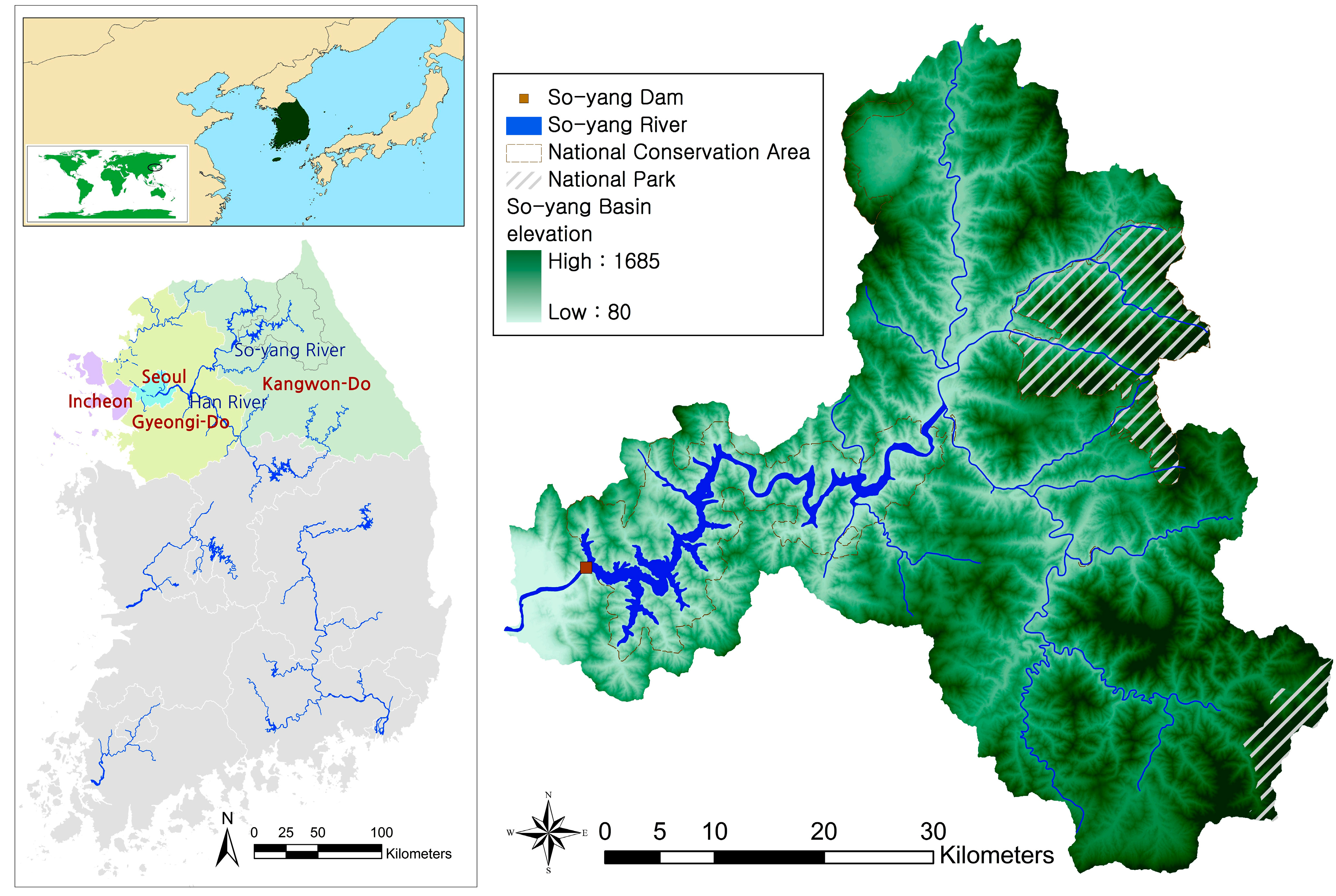
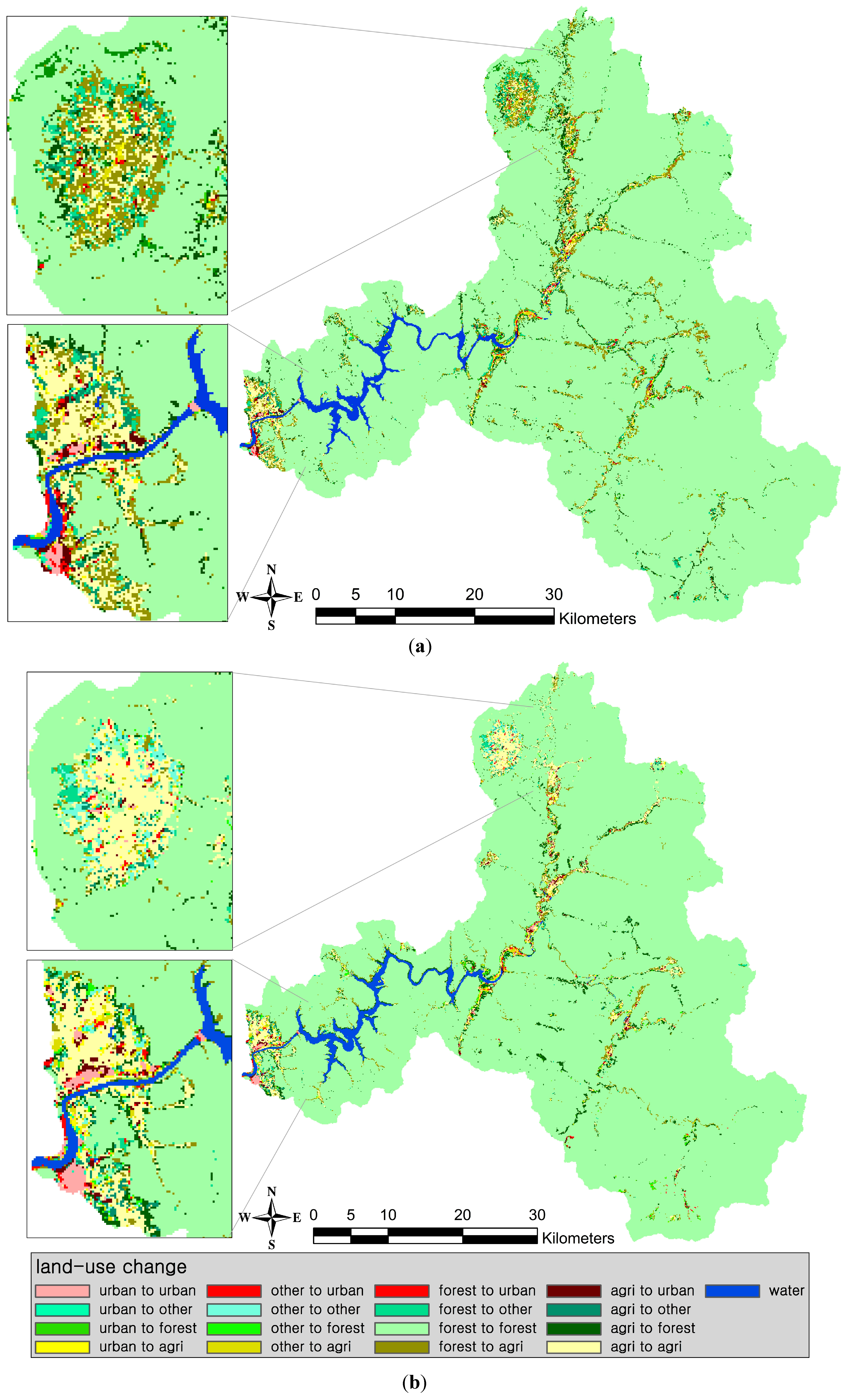
This paper aims to quantify spatio-temporal patterns of land-use and cover changes and their driving factors in a mountainous watershed of South Korea during archetypical periods of land transition (in sensu Foley
et al. [
1]). The period 1980–1990 is characterized by agricultural expansion, deforestation and moderate urbanization. In contrast the period 1990–2000 shows an agricultural contraction, reforestation but severe urbanization. These two periods represent typical land transitions of the region along an economic development path. To fill the gaps in current understanding of such land and cover change in mountainous areas, we examined the effects of neighborhood land-use and environmental factors on land-use changes along with a wide range of other socio-ecological explanatory factors. The general aim is to support regional land-use planning policy and practice, as well as the development of integrated land-use change models in the case study region or other similar areas.
4. Discussion
4.1. Driving Factors of Land-Use Changes
In this study, we identified land-use change patterns in the region, which could be compared with archetypical periods of land transition. After that, we extracted variables, which were used as independent variables in multinomial logistic models to analyze land-use changes in the So-yang River Basin. Our statistical analysis suggests that land-use change factors and enrichment factors show different patterns for the two different time decades, where the degree of some results of the relations of correlation coefficients and directions of effects vary. Although most results correspond with the research hypothesis of factors of land-use changes, some results were unexpected.
4.1.1. Driving Factors of Land-Use Changes in 1980–1990
Biophysical drivers: The first decade was characterized by agricultural expansions, deforestation and urbanization. During the period after a highway to Seoul was constructed in 1975, commercial highland agriculture increased in the Kangwon province, because it was regarded as a new economic income source in rural mountainous areas [
60]. During this period, the impacts of environmental factors like summer rainfall, elevation and slope are in accordance with our hypotheses. We hypothesized that summer rainfall has negative explanatory power in relation to urban and agricultural land-use. This is due to the environmental characteristics of the research site, as people in this region have experienced flood damage frequently due to monsoon periods and typhoons. From the analysis, we could find that agricultural areas are easily changed into other land type areas with lower summer rainfall. Topographic factors, specifically elevation and slope have negative correlations to human induced land-use changes, as expected. Areas with low elevations and gentle slopes are easily converted to agricultural and urban areas, while forest expansions occurred in areas with low accessibility due to topographic limitations. This result is in concurrence with other studies on agricultural abandonment of mountainous areas in Europe [
61] and Asia [
62]. As for upslope contributing areas and wetness index reflecting hydrological and geomorphologic aspects, areas with low upslope contributing area index were converted to agricultural land in the first time period, which does not coincide with our research hypothesis. This result could be explained with rainfall characteristics in the region. Areas with less rainfall intensity during monsoon periods are preferred for new agricultural areas, reflecting the importance of water inflows at upper slopes.
Distance factors and population density: Distance factors and population density have low explanatory powers compared to other variables. This result can be attributed to the fact that land-use changes occur in the narrow basin area of the river, which make it difficult to clarify distance effects. Previous research on forest transition in South Korea concluded that the population factor is one of the major land-use change factors in mountainous areas [
30]. However, population density shows insignificant explanatory power to explain land use changes from our statistical analysis.
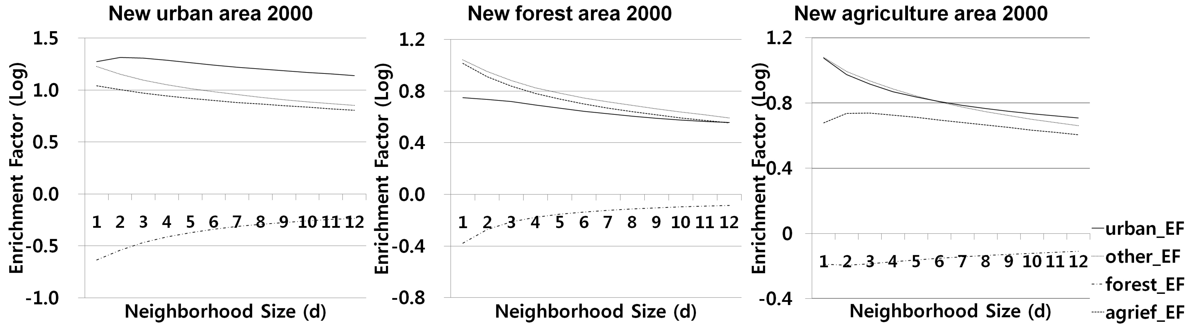
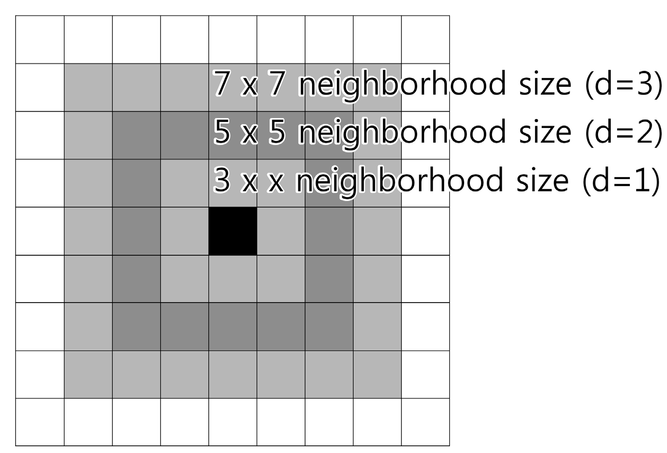
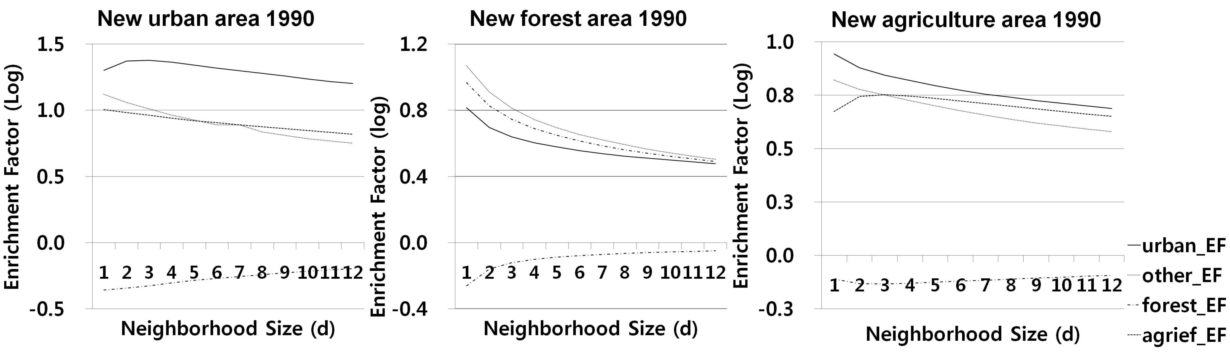
Neighboring land use: Forest areas highly were correlated with neighboring forest factors, especially neighborhood factors of 7 × 7 grid cells. This suggests that land-use changes in the region resulted from spatial policies to restrain urban and agricultural changes near forest areas for security and environmental reasons. Agricultural land in areas dominated by forest is easily converted to forests, which might in addition reflect natural conversions of abandoned fields. However, areas nearest to forest also experienced land-use changes to both urban and agricultural lands. These land-use changes led to highland agriculture occurring in the marginal forest areas. These results show that factors that affect land-use changes differ for each land-use class due to their spatial relations. However, differences between the causal patterns of land use changes in the two periods (1980–1990 and 1990–2000) are relatively low, with the exception of changes of agricultural land-use, meaning that similar driving factors and mechanisms affect land-use changes constantly.
Land regulation policies: Land regulation policies during this phase did not affect urban land-use changes because there already were a few urban areas located in regulation areas. Sol-ak National Park was designated within the Tae-baek mountain range and had been managed strictly since then because it is one of the most famous national parks and sightseeing areas in South Korea. The national park did not affect land-use changes directly after 1980’s. However, forest changes next to urban areas in the 1980’s could be interpreted by the way that tourism facilities in the park areas were increased more than other urban land use types in this period. Comparing national parks and national conservation areas, the latter are more influential with respect to agricultural land-use changes. Since national conservation areas are designated to protect water quality in So-yang Lake, farmlands and farmers were directly affected by this policy and this led to agricultural contraction.
4.1.2. Driving Factors of Land-Use Changes in 1990–2000
Most land-use change factors hypothesized in this research have consistent explanatory powers between the two different time periods. Although similar factors affect to land use changes steadily, there are some differences of land-use change patterns between earlier and later stemming from the decrease of agricultural areas in the second phase. During this period, agriculture decreased all over the catchment except centralized highland agriculture areas such as Hae-an Myeon and Ja-won Ri. This change also generated different results in statistical analysis of land-use change factors.
Biophysical drivers: The explanatory power of rainfall is opposite for forest and agricultural land use changes. Agricultural areas with higher summer rainfall are easily converted to forest areas because of problems derived from an increase of summer rainfall [
63], which could generate planned forestation in the agricultural areas to prevent flood damages in the region. In the earlier period, topographic variables of elevation and slope explain urban and agricultural expansions. However, these tendencies have changed in the subsequent period from 1990 to 2000 indicated by influences of slope factors on agricultural lands. In the later period, areas with gentle slope were more easily converted to agricultural lands. This result reflects expansions of highland farming into smooth mountainous areas. In contrast to urban and agricultural expansions, forest expansion occurs at higher elevations and with increased slope, typically abandoned lands with limited use, especially those within national conservation areas. Due to the land regulations at these sites, forest growth occurred in the processes of natural conversion. This difference stems from geomorphologic characteristics of mountainous areas.
Distance factors, population density, and neighborhood land-use: These factors are similar to their results of MNL analysis when compared with the earlier period of 1980-1990. Distance and population factors are still less affected land-use changes. Neighborhood factors in the later period affect land-use change similarly to those of the earlier period.
Land regulation policies: Land-use in urban areas affected by land regulation in the later period, barely changes for the entire period.
4.2. Underlying Factors of Land-Use Changes in the So-Yang River Basin
We tried to find driving factors of land-use changes. However, land-use changes are affected by various factors because of the complex characteristics of human-environmental systems, which are difficult to derive from statistical results. In this chapter, we described underlying factors from literature reviews and briefly compare them with the statistical results which are suggested as major land-use change factors in the local communities.
With respect to urban areas, deregulation in green belt areas to ease local development and improve accessibility by constructing roads and bridges are important land-use change factors [
64]. In particular, policy changes in 1994 to utilize lands surrounding water sources generated expansions of urban areas in the marginal forest [
65]. However, results of statistical analysis with distance and neighboring factors could not support these findings.
Land abandonment with population migration after zoning policies and dam constructions since 1970’s generated growth of natural forest. So-yang Lake generates local climates changes, such as increased days with fog and frost, which worsen agricultural conditions and productivity as well as residential health status [
33,
60]. Moreover, dam constructions brought about a raise of agricultural and living costs by worsening accessibility, and while zoning policies made it more difficult to utilize lands efficiently and get higher income [
32,
33]. These underlying factors could be linked with the results for topographic variables.
Although overall agricultural areas decreased during the period, agricultural expansions occurred in highland farming areas influenced by socio-economic factors such as income improvement in highland crops and support policies for agriculture, which expand cultivation areas of household and reclamation of forest areas [
65]. Apart from this reason, political factors affected agricultural land-use changes. Korean agricultural households and societies faced economic crisis after the launch of WTO systems in 1995. To solve this problem, the central government tried to introduce various policies to maintain agricultural sectors, such as farm subsidies and deregulations in agricultural land uses. The Korean government introduced a direct payment system for aged farmers’ early retirement and environmentally friendly farming practice since the late 1990’s to preserve the income of rural households and promote environmentally friendly farming as a new income source [
66]. Regulation policies, such as maximum holdings of farmland and lands to the tillers principle regulating landholdings of no-till farmers, were regarded as troublesome factors for agricultural activities in agricultural areas. After the government eased these regulations, land owners could easily increase their land extent with advanced technologies. Aside from these political factors, recent climate changes brought about agro-environmental changes such as temperature rise, intensive rainfall in summer monsoon periods, reduced sunshine hours and fruit cultivation areas advancing north, in the Tae-back mountain range as well as other high elevation areas [
63].
4.3. Limitations and the Way Forward
The challenge of this study is related to acquisition of spatial data for land-use changes, population data for driving factors and land use regulation maps for the research site. Land use maps used in the research were produced by an institution of the Korean government as explained in the earlier chapter. Although they had higher reliability compared to other maps, these also had problems with accuracy of classification because they were produced based on different Landsat satellite images. Maps of 1980 were built on Landsat MSS with 60 m resolution, however other maps of 1990 and 2000 were based on Landsat TM with 30 m resolution. This resolution differences may reduce accuracies of “trace” LUCC (i.e., the LUCC areas with only a few 30 m × 30 m pixels. As these differences could affect data accuracy, we used these data by merging pixel resolution, thereby reducing this problem.
Data acquisition significantly affects the accuracy of the land use model [
11]. In our study, it was especially problematic to get socio-economic data for detailed administrative areas and to convert these data into spatial data. Although some policy factors like zoning area have spatial dimensions for policy implementations, such low spatial differences of this variable within the study area weakened the measurement of its effect on LUCC when using the spatial statistical models. Moreover, many underlying land-use change factors, such as expansions of highland farming, are difficult to find from this quantitative approach due to data limitations. The same limitation might extend to population density as the population data obtained was based on administrative areas, which means all areas or cells in an administration unit have the same numbers. The weak or null effects of these less spatially distributed variables do not necessarily mean lower importance of these variables in reality [
30].
The problems of these socio-economic drivers could be moderated through some actor-based follow-up studies reflecting land use decisions. To do so, we could use household surveys to acquire socio-economic data and develop decision models for land use actors. Otherwise, it is necessary to develop methods for spatial disaggregation of statistical data in mountainous regions.
5. Conclusions
In this study, we aimed to find land-use change patterns and factors using logistic regression methods to develop statistical models of land-use changes. We extracted neighborhood variables as an index of enrichment factors and various environmental data used as independent variables in multinomial logistic models. After calculating these factors, we quantified relationships between land-use changes and their driving factors to urban, forest, and agricultural lands in the So-yang River Basin using three types of multinomial logistic regression. From this statistical analysis, it was concluded that driving factors and enrichment factors showed similar patterns for two different time periods, meaning that similar processes affect land-use changes constantly in Asian mountainous watershed areas. Statistical results indicate that topographic and neighborhood factors are major driving factors in urban, forest and agricultural land-use changes, corresponding with most hypothesized effects on land-use change. Although major land-use change factors consistently affect all land-use changes, these specific models could help to understand spatial determinants of land-use change processes. It turned out that land-use change models should be subdivided into specific land-use types to utilize driving factors of different land-use types. Driving factors reflecting spatial relations could define transition rules in the land-use change models. In particular, simulation models for future land-use changes could be developed based on the results of our research. When we compared two models for different time periods, there were some similarities among LUCC factors. On the other side they represent two archetypical situations. In the earlier period, agricultural expansion, deforestation and moderate urbanization were dominating, while the later was characterized by agricultural contraction, reforestation and severe urbanization. These factors can be used in simulation models (e.g. cellular automata models) for LUCC changes by quantifying transitional rules and land conversion probabilities of land-use changes for specific pixels (e.g. cellular automata models), and by setting neighborhood thresholds for neighborhood interactions. Moreover, we described various underlying factors which are difficult to be found in statistical results, but are relevant for constructing socio-economic and policy scenarios. These land-use simulation models potentially could contribute to enhance policy making with land-use plans and regional environmental management.


